historic bridges - tennessee state government - … historic bridges ... beginning with the...
TRANSCRIPT

6HISTORIC BRIDGES

Cordell Hull Bridge: This historic postcard shows an elevation view of the NationalRegister eligible Cordell Hull Bridge (#139, 80-SR025-11.32). Spanning the Cumberland Riverin Carthage in Smith County, the state built the bridge with New Deal money and named itin honor of Carthage native and Nobel Peace Prize winner Cordell Hull (Author’sCollection).

324 HISTORIC BRIDGESSU
RVEY
REP
ORT
FO
R H
ISTO
RIC
HIG
HW
AY B
RID
GES
HISTORIC BRIDGES IN TENNESSEE
This chapter contains a discussion of each National Register listed or eligible bridge identifiedin this survey. The staff considered several ways to sequentially arrange these bridges such aschronologically, geographically, or construction method. The staff ultimately decided toarrange the bridges chronologically, beginning with the state’s earliest masonry arch bridgesdating from about 1830-1850 and ending with truss bridges built in the 1940s, as enumeratedin Table VI-01. The advantages of such an arrangement included an overview of constructionperiods and trends that provided a comparative engineering context. It also reflected theoverlapping nature of bridge construction in that there are no definitive beginning and endingdates for construction types but rather parallel and concurrent movements that evolvedwithin the bridge building industry.
To facilitate finding bridges geographically, a chart (Table VI-02) enumerates the bridges bycounty locations. Chapters Four and Five contain a discussion of bridges by constructionmethod.
Due to time limitations, TDOT historians have conducted this survey sporadically over aperiod of several years. In the interim, replacement projects have resulted in the demolitionof some of these bridges. In order to provide a contextual overview of the eligibility decisionmaking process, the survey includes demolished bridges with a discussion of their disposition.Although replacement projects may have resulted in the demolition of some historic bridges,municipalities working through the TennesseeDepartment of Transportation and the FederalHighway Administration retained several ofthese bridges through preservation in place orthrough relocation of the truss spans.
The bridges are arranged in three generalbridge building periods in Tennessee: fromabout 1830 through 1901; from 1901 through1920 and the development of the statehighway department; and from 1921 throughthe end of World War II. Before each group ofbridges is a brief historical overview.
Figure VI-01: TDOTPhotographer GeorgeHornal photo-documentingthe Massengill Bridge priorto its demolition.

325HISTORIC BRIDGESSU
RVEY REPORT FO
R HISTO
RIC H
IGH
WAY BRID
GES
TABLE VI-01: CHRONOLOGICAL LIST OF NATIONAL REGISTERLISTED OR ELIGIBLE BRIDGES

326 HISTORIC BRIDGESSU
RVEY
REP
ORT
FO
R H
ISTO
RIC
HIG
HW
AY B
RID
GES
24 Marion 58-A0502-00.36 Battle Creek 1891 1 Pratt Through
25 Sequatchie 77-NonHighway-1 Sequatchie Rv 1893 ca 1 Pratt Through
26 Bradley 06-A0165-00.21 Candies Creek 1895 3 Pratt Half-hip Pony
27 Knox 47-03775-00.26 Tennessee
River
1896-98 1 5-span continuous Pratt
Deck-Arched
28 Grundy 31-NonHighway-3 Scott Creek 1898 2 Masonry Arches
29 Roane 73-A0323-02.19 Paint Rock Cr 1898 1 Pratt Bedstead Pony
30 Sevier 78-00496-07.09 Boyds Creek 1898 1 Masonry Arch
31 Sullivan 82-NonHighway-1 Beaver Creek 1898 1 Pratt Through
32 Cheatham 11-01931-00.45 Harpeth River 1898;
1911
2 Pratt Through,
1 Built-up Plate Girder
33 Davidson 19-NonHighway-9 Richland Creek 1900 ca 1 Double Intersection
Warren Pony
34 Sumner 83-NonHighway-4 Dry Fork Creek 1900 ca 1 Double Intersection
Warren Pony
35 Lincoln 52-NonHighway-3 Elk River 1901 1 Camelback Through,
2 Pratt Pony
36 Washington 90-A0900-00.97 Nolichucky Rv 1901-02 2 Pratt Thru, 1 Pratt Pony
37 Giles 28-A0153-01.95 Elk River 1902 1 Pennsylvania Petit Thru
38 Stewart 81-NonHighway-2 South Cross Cr 1902 1 Pratt Through
39 Sullivan 82-A0872-00.05 S Fk Holston Rv 1902-03 1 Camelback, 1 Pratt Thru
40 Hardin 36-NonHighway-1 Snake Creek 1903 1 Pratt Through
41 Maury 60-NonHighway-1 Duck River 1903 1 Penn Petit Thru,
1 Pratt Half-hip Pony
42 Humphreys 43-NonHighway-1 Duck River 1903-04 2 Camelback Through
43 Maury 60-NonHighway-2 Duck River 1903-04 1 Camelback Through
44 Shelby 79-E0578-00.21 Frisco Railroad 1903-05 1 Closed Spandrel Arch
45 Bedford 02-A0048-00.38 N Fork Creek 1904 1 Pratt Through
46 Davidson 19-D0981-02.00 Harpeth River 1904 3 Warren Pony
47 Dickson 22-01864-02.86 Jones Creek 1904 1 Pratt Through
48 Knox 47-A0135-00.42 Railroads 1905 10 Closed Spandrel Arch
49 Robertson 74-00979-01.58 Sulphur Fk Cr 1905 1 Camelback Through
50 Coffee 16-P0001-00.02 Duck River 1906 1 Pratt Through
51 Davidson 19-B0983-01.61 Richland Creek 1906 1 Closed Spandrel Arch

327HISTORIC BRIDGESSU
RVEY REPORT FO
R HISTO
RIC H
IGH
WAY BRID
GES
52 Grundy 31-NonHighway-2 Firescald
Creek
1906 1 Masonry Arch
53 Marion 58-A0443-00.50 Poplar Spring Br 1906 1 Closed Spandrel Arch
54 Perry 68-NonHighway-2 Buffalo River 1906 1 Camelback Through,
1 Pratt Pony
55 Hickman 41-NonHighway-1 Duck River 1907 1 Penn Petit, 1 Pratt Thru;
1 Warren Pony
56 Smith 80-A0206-00.47 Lick Creek 1907 1 Pratt Pony
57 Smith 80-NonHighway-3 Caney Fork
River
1907-08 1 Camelback Through,
1 Pratt Deck, &
1 Pratt Half-hip Deck
58 Davidson 19-03245-01.47 Cumberland Rv 1907-09 1 Parker,2 Camelback Thru
59 DeKalb 21-A0028-01.21 Smith Fork Cr 1908 2 Warren Pony
60 Greene 30-A0934-00.16 Lick Creek 1908 1 Pratt Half-hip Pony
61 Van Buren 88-NonHighway-1 Cane Creek 1908;
1924
1 Pratt Through, &
1 Warren Pony
62 Davidson 19-NonHighway-1 Richland Creek 1908-10 1 Warren Pony
63 Franklin 26-A0406-00.33 Wagner Creek 1909 1 Pratt Through
64 Grainger 29-A0051-00.06 Flat Creek 1909 1 Pratt Half-hip Pony
65 Meigs 61-NonHighway-1 Big Sewee Cr 1909-10 1 Pratt Bedstead Pony
66 Davidson 19-NonHighway-4 Duck Pond 1910 1 Closed Spandrel Arch
67 Obion 66-NonHighway-1 Obion River
Drainage Canal
1910-12 1 Covered Kingpost
68 Humphreys 43-A0340-00.01 Hurricane Cr 1911 1 Pratt Through
69 McMinn 54-A0214-00.10 L & N Railroad 1911 1 Kingpost Pony
70 Polk 70-01223-02.53 Hiwassee River 1911 1 Parker & 2 Pratt Through
71 Grundy 31-A0022-02.49 Hickory Creek 1912 2 Masonry Arches
72 Polk 70-SR315-00.02 Hiwassee River 1912 5 Pratt Through
73 White 93-A0285-00.95 Lost Creek 1912 1 Pratt Pony
74 Polk 70-A0317-02.09 L & N Railroad 1913 1 Queenpost Pony
75 Sullivan 82-C0539-00.01 S Fk Holston Rv 1913 3 Pratt Through
76 Sumner 83-NonHighway-1 Caney Fork Cr 1913 1 Warren (PTC) Pony
77 Shelby 79-NonHighway-4 Mississippi
River
1913-17 1 4-span Continuous
Through, 1 Warren Deck

328 HISTORIC BRIDGESSU
RVEY
REP
ORT
FO
R H
ISTO
RIC
HIG
HW
AY B
RID
GES
78 Franklin 26-NonHighway-1 Factory Creek 1914 ca 2 Masonry Arches
79 Giles 28-01891-04.77 Big Creek 1914 2 Closed Spandrel Arches
80 Loudon 53-02507-08.23 Pond Creek 1914 1 Closed Spandrel Arch
81 Meigs 61-A0028-00.23 Big Sewee Cr 1914 1 Pratt Through
82 Monroe 62-A0520-02.45 L & N Railroad 1914 1 Queenpost Pony
83 Obion 66-NonHighway-2 S Fk Indian Cr 1914 1 Warren Pony
84 Perry 68-NonHighway-1 Buffalo River 1914 1 Camelback Through,
2 Pratt Pony
85 Hamilton 33-SR008-09.53 Tennessee
River
1914-17 1 Steel Arch/Bascule Lift,
6 Closed Spandrel Arches
86 Roane 73-01226-00.50 Emory River 1915-18 7 Closed Spandrel Arches
87 Anderson 01-A0088-03.53 Clinch River 1916 1 Camelback & 2 Pratt
Through, 1 Pratt Pony
88 Maury 60-A0358-00.42 Big Bigby Cr 1916 5 Closed Spandrel Arches
89 Unicoi 86-A0068-00.89 Nolichucky Rv 1916 5 Closed Spandrel Arches
90 Washington 90-B0586-00.00 Watauga River 1916 2 Pennsylvania Petit Thru
91 Grainger 29-A0025-02.62 Hogskin Creek 1916-17 1 Camelback Through
92 Dyer 23-NonHighway-1 Lake 1917 1 Pratt Pony Swing
93 Hawkins 37-A0131-01.67 Poor Valley Cr 1917 1 Warren Pony
94 Maury 60-NonHighway-4 Beard Branch 1917 1 Closed Spandrel Arch
95 Meigs 61-NonHighway-2 Big Sewee Cr 1917 1 Pratt Bedstead Pony
96 White 93-A0415-00.19 L & N Railroad 1917-18 1 Queenpost Pony
97 Anderson 01-02444-06.74 L & N Railroad 1918 1 Kingpost Pony
98 Blount 05-NonHighway-1 Little River 1918 3 Closed Spandrel Arches
99 Giles 28-A0340-00.83 L & N Railroad 1918 1 Kingpost Pony
100 Smith 80-01068-03.16 Hickman Creek 1920 4 Closed Spandrel Arches
101 Madison 57-01644-00.05 S Fork Forked
Deer River
1920-21 1 Warren Through
102 Greene 30-NonHighway-1 Camp Creek 1921 1 Open Spandrel Arch
103 Wilson 95-02036-01.51 Round Lick Cr 1921 2 Closed Spandrel Arches
104 Giles 28-A0334-00.33 Jenkins Branch 1921-22 1 Closed Spandrel Arch
105 Giles 28-A0002-00.23 Factory Creek 1922 1 Closed Spandrel-Ribbed
329HISTORIC BRIDGESSU
RVEY REPORT FO
R HISTO
RIC H
IGH
WAY BRID
GES
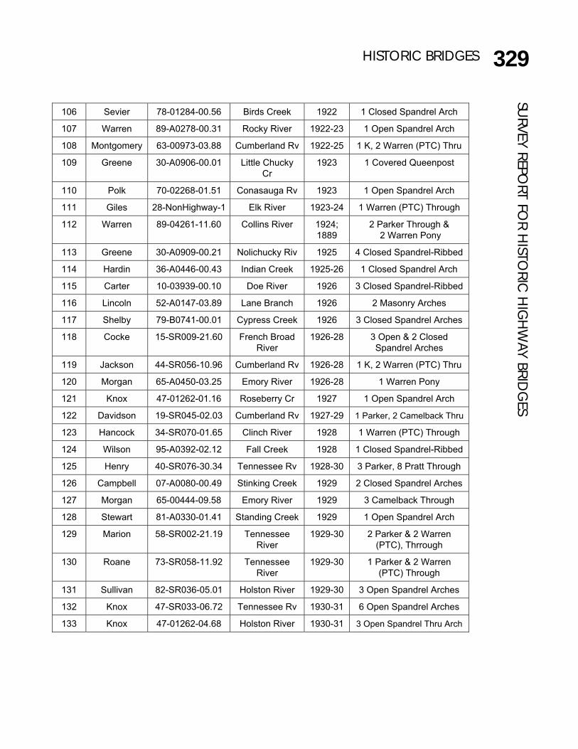
106 Sevier 78-01284-00.56 Birds Creek 1922 1 Closed Spandrel Arch
107 Warren 89-A0278-00.31 Rocky River 1922-23 1 Open Spandrel Arch
108 Montgomery 63-00973-03.88 Cumberland Rv 1922-25 1 K, 2 Warren (PTC) Thru
109 Greene 30-A0906-00.01 Little Chucky
Cr
1923 1 Covered Queenpost
110 Polk 70-02268-01.51 Conasauga Rv 1923 1 Open Spandrel Arch
111 Giles 28-NonHighway-1 Elk River 1923-24 1 Warren (PTC) Through
112 Warren 89-04261-11.60 Collins River 1924;
1889
2 Parker Through &
2 Warren Pony
113 Greene 30-A0909-00.21 Nolichucky Riv 1925 4 Closed Spandrel-Ribbed
114 Hardin 36-A0446-00.43 Indian Creek 1925-26 1 Closed Spandrel Arch
115 Carter 10-03939-00.10 Doe River 1926 3 Closed Spandrel-Ribbed
116 Lincoln 52-A0147-03.89 Lane Branch 1926 2 Masonry Arches
117 Shelby 79-B0741-00.01 Cypress Creek 1926 3 Closed Spandrel Arches
118 Cocke 15-SR009-21.60 French Broad
River
1926-28 3 Open & 2 Closed
Spandrel Arches
119 Jackson 44-SR056-10.96 Cumberland Rv 1926-28 1 K, 2 Warren (PTC) Thru
120 Morgan 65-A0450-03.25 Emory River 1926-28 1 Warren Pony
121 Knox 47-01262-01.16 Roseberry Cr 1927 1 Open Spandrel Arch
122 Davidson 19-SR045-02.03 Cumberland Rv 1927-29 1 Parker, 2 Camelback Thru
123 Hancock 34-SR070-01.65 Clinch River 1928 1 Warren (PTC) Through
124 Wilson 95-A0392-02.12 Fall Creek 1928 1 Closed Spandrel-Ribbed
125 Henry 40-SR076-30.34 Tennessee Rv 1928-30 3 Parker, 8 Pratt Through
126 Campbell 07-A0080-00.49 Stinking Creek 1929 2 Closed Spandrel Arches
127 Morgan 65-00444-09.58 Emory River 1929 3 Camelback Through
128 Stewart 81-A0330-01.41 Standing Creek 1929 1 Open Spandrel Arch
129 Marion 58-SR002-21.19 Tennessee
River
1929-30 2 Parker & 2 Warren
(PTC), Thrrough
130 Roane 73-SR058-11.92 Tennessee
River
1929-30 1 Parker & 2 Warren
(PTC) Through
131 Sullivan 82-SR036-05.01 Holston River 1929-30 3 Open Spandrel Arches
132 Knox 47-SR033-06.72 Tennessee Rv 1930-31 6 Open Spandrel Arches
133 Knox 47-01262-04.68 Holston River 1930-31 3 Open Spandrel Thru Arch

330 HISTORIC BRIDGESSU
RVEY
REP
ORT
FO
R H
ISTO
RIC
HIG
HW
AY B
RID
GES
134 Anderson 01-A0136-01.96 Hinds Creek 1931 1 Closed Spandrel-Ribbed
135 Monroe 62-02340-13.67 Tellico River 1931 1 Pratt Pony
136 Anderson 01-SR071-01.96 Hinds Creek 1934 1 Closed Spandrel Arch
137 Cumberland 18-01168-03.76 Byrds Creek 1934 1 Masonry Arch
138 Greene 30-SR070-08.48 Nolichucky
River
1934-35 1 3-span Continuous
Warren Deck
139 Smith 80-SR025-11.32 Cumberland
River
1934-36 1 Modified Parker Thru & 2
Warren Deck Continuous
3-span Truss, 6 Modified
Warren Deck
140 Union 87-SR033-15.83 Clinch River 1934-36 2 2-span Continuous
Warren (PTC) Through
141 Sevier 78-SR071-05.85 State Route 71 1935 1 Closed Spandrel Arch
142 Sevier 78-SR071-08.54 W Prong Little
Pigeon River
1936 1 Closed Spandrel Arch
143 Sevier 78-SR071-05.65 Cole Branch 1936-37 1 Closed Spandrel Arch
144 Sevier 78-SR071-05.23 Walker Camp
Prong
1936-37 2 Closed Spandrel Arches
145 Sevier 78-SR071-02.83 W Prong Little
Pigeon River
1936-37 1 Closed Spandrel Arch
146 Sevier 78-SR071-01.98 Walker Camp
Prong
1936-37 1 Closed Spandrel Arch
147 Cumberland 18-01166-03.59 Byrds Crk/Lake 1936-38 15 Closed Spandrel Arch
148 Sevier 78-SR071-13.31 W Prong Little
Pigeon River
1937 3 Closed Spandrel Arches
149 Cumberland 18-A0939-01.00 Byrds Creek 1937 ca 1 Masonry Arch
150 Fentress 25-SR028-29.24 Wolf River 1939-40 1 Pratt Through
151 Davidson 19-NonHighway-3 Drakes Branch 1941 1 (Metal) Kingpost Pony
152 Jefferson 45-SR092-09.21 French Broad
River
1942-44 1 3-span Continuous
Warren (PTC) Through
153 Roane 73-00653-04.34 Poplar Creek 1943 ca 3 Bailey Pony
154 Pickett 69-SR042-03.27 Obey River 1943-46 3 Parker & 3 Warren
(PTC) Through
155 Shelby 79-I055-12.00 Mississippi
River
1949-50 1 5-Continuous Warren
(PTC) (Through)
156 Hamilton 33-01151-00.78 Sale Creek 1954 1 Warren (PTC) Pony
331HISTORIC BRIDGESSU
RVEY REPORT FO
R HISTO
RIC H
IGH
WAY BRID
GES
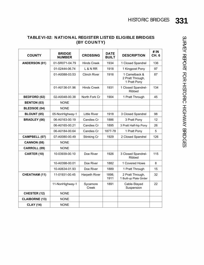
TABLE VI-02: NATIONAL REGISTER LISTED ELIGIBLE BRIDGES (BY COUNTY)
COUNTY
BRIDGE NUMBER
CROSSING
DATE BUILT
DESCRIPTION
# IN CH. 6
01-SR071-04.79 Hinds Creek 1934 1 Closed Spandrel 136
01-02444-06.74 L & N RR 1918 1 Kingpost Pony 97
01-A0088-03.53 Clinch River 1916 1 Camelback &
2 Pratt Through,
1 Pratt Pony
87
ANDERSON (01)
01-A0136-01.96 Hinds Creek 1931 1 Closed Spandrel-
Ribbed
134
BEDFORD (02) 02-A0048-00.38 North Fork Cr 1904 1 Pratt Through 45
BENTON (03) NONE
BLEDSOE (04) NONE
BLOUNT (05) 05-NonHighway-1 Little River 1918 3 Closed Spandrel 98
06-A0163-00.19 Candies Cr 1886 3 Pratt Pony 12
06-A0165-00.21 Candies Cr 1895 3 Pratt Half-hip Pony 26
BRADLEY (06)
06-A0184-00.64 Candies Cr 1877-78 1 Pratt Pony 5
CAMPBELL (07) 07-A0080-00.49 Stinking Cr 1929 2 Closed Spandrel 126
CANNON (08) NONE
CARROLL (09) NONE
10-03939-00.10 Doe River 1926 3 Closed Spandrel-
Ribbed
115
10-A0398-00.01 Doe River 1882 1 Covered Howe 8
CARTER (10)
10-A0634-01.93 Doe River 1889 1 Pratt Through 15
11-01931-00.45 Harpeth River 1898;
1911
2 Pratt Through,
1 Built-up Plate Girder
32 CHEATHAM (11)
11-NonHighway-1 Sycamore
Creek
1891 Cable-Stayed
Suspension
22
CHESTER (12) NONE
CLAIBORNE (13) NONE
CLAY (14) NONE

332 HISTORIC BRIDGES
COCKE (15) 15 SR009-21.60 French Broad
River
1926-28 3 Open & 2 Closed
Spandrel
118
COFFEE (16) 16-P0001-00.02 Duck River 1906 1 Pratt Through 50
CROCKETT (17) NONE
18-01166-03.59 Byrds Cr/Lake 1936-38 15 Closed Spandrel 147
18-01168-03.76 Byrds Creek 1934 1 Masonry Arch 137
CUMBERLAND (18)
18-A0939-01.00 Byrds Creek ca. 1937 1 Masonry Arch 149
19-SR045-02.03 Cumberland
River
1927-29 1 Parker &
2 Camelback Thru
122
19-03245-01.47 Cumberland
River
1907-09 1 Parker &
2 Camelback Thru
58
19-B0983-01.61 Richland Cr 1906 1 Closed Spandrel 51
19-D0981-02.00 Harpeth Rv 1904 3 Warren Pony 46
19-E0224-00.07 Manskers Cr ca. 1841 2 Masonry Arches 1
19-NonHighway-1 Richland Cr 1908-10 1 Warren Pony 62
19-NonHighway-2 S Harpeth Rv 1889 1 Parker Through 16
19-NonHighway-3 Drakes Br 1941 1 Kingpost Pony 151
19-NonHighway-4 Duck Pond 1910 1 Closed Spandrel 66
19-NonHighway-8 Browns Creek 1888 1 Masonry Arch 13
DAVIDSON (19)
19-NonHighway-9 Richland
Creek
1900 ca 1 Double Intersection
Warren Pony
33
DECATUR (20) NONE
DEKALB (21) 21-A0028-01.21 Smith Fk Cr 1908 2 Warren Pony 59
DICKSON (22) 22-01864-02.86 Jones Creek 1904 1 Pratt Through 47
DYER (23) 23-NonHighway-1 Lake 1917 1 Pratt Pony Swing 92
FAYETTE (24) NONE
FENTRESS (25) 25-SR028-29.24 Wolf River 1939-40 1 Pratt Through 150
26-A0406-00.33 Wagner Cr 1909 1 Pratt Through 63 FRANKLIN (26)
26-NonHighway-1 Factory Cr ca. 1914 2 Masonry Arches 78
GIBSON (27) NONE
SURV
EY R
EPO
RT F
OR
HIS
TORI
C H
IGH
WAY
BRI
DG
ES

333HISTORIC BRIDGES
28-00966-03.54 Big Creek 1884 1 Warren Pony 9
28-01891-04.77 Big Creek 1914 2 Closed Spandrel 79
28-A0002-00.23 Factory Creek 1922 1 Closed Spandrel-
Ribbed
105
28-A0153-01.95 Elk River 1902 1 Penn Petit Thru 37
28-A0334-00.03 Jenkins Br 1921-22 1 Closed Spandrel 104
28-A0340-00.83 L & N RR 1918 1 Kingpost Pony 99
GILES (28)
28-NonHighway-1 Elk River 1923-24 1 Warren-PTC Thru 111
29-A0025-02.62 Hogskin Creek 1916-17 1 Camelback Thru 91 GRAINGER (29)
29-A0051-00.06 Flat Creek 1909 1 Pratt Half-hip Pony 64
30-SR070-08.48 Nolichucky
River
1934-35 1 3-span Continuous
Warren Deck
138
30-A0906-00.01 Little Chucky Cr 1923 1 Covered
Queenpost
109
30-A0909-00.21 Nolichucky
River
1925 4 Closed Spandrel-
Ribbed
113
30-A0934-00.16 Lick Creek 1908 1 Pratt Half-hip Pony 60
GREENE (30)
30-NonHighway-1 Camp Creek 1921 1 Open Spandrel 102
31-A0022-02.49 Hickory Cr 1912 2 Masonry Arches 71
31-NonHighway-2 Firescald Cr 1906 1 Masonry Arch 52
GRUNDY (31)
31-NonHighway-3 Scott Creek 1898 2 Masonry Arches 28
HAMBLEN (32) NONE
33-SR008-09.53 Tennessee
River
1914-17 1 Steel Arch
(Bascule Lift) &
6 Closed Spandrel
85
33-01151-00.78 Sale Creek 1954 1 Warren-PTC Pony 155
HAMILTON (33)
33-03544-00.12 Tennessee Rv 1889-91 6 Camelback Thru 20
HANCOCK (34) 34-SR070-01.65 Clinch River 1928 1 Warren-PTC Thru 123
HARDEMAN (35) NONE
36-A0446-00.43 Indian Creek 1925-26 1 Closed Spandrel 114 HARDIN (36)
36-NonHighway-1 Snake Creek 1903 1 Pratt Through 40
HAWKINS (37) 37-A0131-01.67 Poor Valley Cr 1917 1 Warren Pony 93
HAYWOOD (38) NONE
HENDERSON (39) NONE
156
SURVEY REPO
RT FOR H
ISTORIC
HIG
HW
AY BRIDG
ES

334 HISTORIC BRIDGES
HENRY (40) 40-SR076-30.34 Tennessee Rv 1928-30 3 Parker, 8 Pratt Thru 125
HICKMAN (41) 41-NonHighway-1 Duck River 1907 1 Pennsylvania Petit
& 1 Pratt Through,
1 Warren Pony
55
HOUSTON (42) NONE
43-A0340-00.01 Hurricane Cr 1911 1 Pratt Through 68 HUMPHREYS (43)
43-NonHighway-1 Duck River 1903-04 2 Camelback Thru 42
JACKSON (44) 44-SR056-10.96 Cumberland
River
1926-28 1 K & 2 Warren
(PTC) Through
119
JEFFERSON (45) 45-SR092-09.21 French Broad
River
1942-44 1 3-Span
Continuous Warren
(PTC) Through
152
JOHNSON (46) NONE
47-SR033-06.72 Tennessee Rv 1930-31 6 Open Spandrel 132
47-01262-01.16 Roseberry Cr 1927 1 Open Spandrel 121
47-01262-04.68 Holston River 1930-31 3 Open Spandrel
Through
133
47-03775-00.26 Tennessee
River
1896-98 1 5-span Continuous
Pratt Deck-Arched
27
KNOX (47)
47-A0135-00.42 Railroads 1905 10 Closed Spandrel 48
LAKE (48) NONE
LAUDERDALE (49) NONE
LAWRENCE (50) NONE
LEWIS (51) NONE
52-SR274-06.82 Coldwater Cr 1889 2 Warren Pony 18
52-A0147-03.89 Lane Branch 1926 2 Masonry Arches 116
52-A0183-05.54 Elk River 1878 1 Bowstring Through 6
52-A0487-04.85 Elk River 1889 1 Whipple Thru,
1 Pratt Half-hip Pony
17
52-A0494-00.22 Elk River 1891 1 Baltimore Petit
Through &
2 Pratt Half-hip Pony
23
LINCOLN (52)
52-NonHighway-3 Elk River 1901 1 Camelback Thru &
2 Pratt Pony
35
SURV
EY R
EPO
RT F
OR
HIS
TORI
C H
IGH
WAY
BRI
DG
ES

335HISTORIC BRIDGES
LOUDON (53) 53-02507-08.23 Pond Creek 1914 1 Closed Spandrel 80
McMINN (54) 54-A0214-00.10 L & N Railroad 1911 1 Kingpost Pony 69
McNAIRY (55) NONE
MACON (56) NONE
MADISON (57) 57-01644-00.05 S Fork Forked
Deer River
1920-21 1 Warren Through 101
58-SR002-21.19 Tennessee
River
1929-30 2 Parker & 2 Warren
(PTC) Through
129
58-A0443-00.50 Poplar Spring Br 1906 1 Closed Spandrel 53
MARION (58)
58-A0502-00.36 Battle Creek 1891 1 Pratt Through 24
MARSHALL (59) NONE
60-A0358-00.42 Big Bigby Cr 1916 5 Closed Spandrel 88
60-NonHighway-1 Duck River 1903 1 Pennsylvania Petit
Through, 1 Pratt
Half-hip Pony
41
60-NonHighway-2 Duck River 1903-04 1 Camelback Thru 43
MAURY (60)
60-NonHighway-4 Beard Branch 1917 1 Closed Spandrel 94
61-A0022-01.04 Sewee Creek 1884 1 Pratt Through 10
61-A0028-00.23 Big Sewee
Creek
1914 1 Pratt Through 81
61-NonHighway-1 Big Sewee
Creek
1909-10 1 Pratt Bedstead
Pony
65
MEIGS (61)
61-NonHighway-2 Big Sewee
Creek
1917 1 Pratt Bedstead
Pony
95
62-02340-13.67 Tellico River 1931 1 Pratt Pony 135 MONROE (62)
62-A0520-02.45 L & N Railroad 1914 1 Queenpost Pony 82
63-00973-03.88 Cumberland
River
1922-25 1 K & 2 Warren
(PTC) Through
108 MONTGOMERY
(63)
63-A0456-01.88 Sulphur Fk Cr 1890 1 Pratt Through 21
MOORE (64) NONE
65-00444-09.58 Emory River 1929 3 Camelback Thru 127
65-A0450-03.25 Emory River 1926-28 1 Warren Pony 120
MORGAN (65)
65-NonHighway-1 White Oak
Creek
1880 ca;
1920s
1880 substructure;
1 Warren Pony
7
SURVEY REPO
RT FOR H
ISTORIC
HIG
HW
AY BRIDG
ES
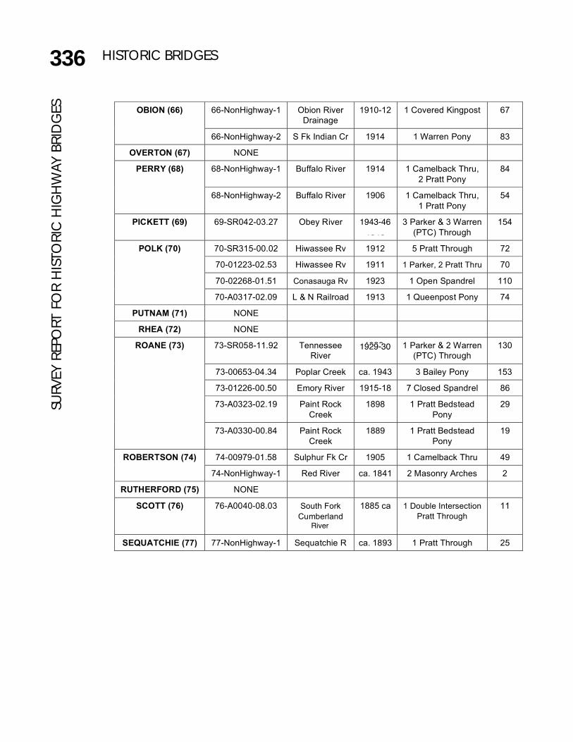
336 HISTORIC BRIDGES
66-NonHighway-1 Obion River
Drainage
1910-12 1 Covered Kingpost 67 OBION (66)
66-NonHighway-2 S Fk Indian Cr 1914 1 Warren Pony 83
OVERTON (67) NONE
68-NonHighway-1 Buffalo River 1914 1 Camelback Thru,
2 Pratt Pony
84 PERRY (68)
68-NonHighway-2 Buffalo River 1906 1 Camelback Thru,
1 Pratt Pony
54
PICKETT (69) 69-SR042-03.27 Obey River 1943-
1946
3 Parker & 3 Warren
(PTC) Through
154
70-SR315-00.02 Hiwassee Rv 1912 5 Pratt Through 72
70-01223-02.53 Hiwassee Rv 1911 1 Parker, 2 Pratt Thru 70
70-02268-01.51 Conasauga Rv 1923 1 Open Spandrel 110
POLK (70)
70-A0317-02.09 L & N Railroad 1913 1 Queenpost Pony 74
PUTNAM (71) NONE
RHEA (72) NONE
73-SR058-11.92 Tennessee
River
1929-
1930
1 Parker & 2 Warren
(PTC) Through
130
73-00653-04.34 Poplar Creek ca. 1943 3 Bailey Pony 153
73-01226-00.50 Emory River 1915-18 7 Closed Spandrel 86
73-A0323-02.19 Paint Rock
Creek
1898 1 Pratt Bedstead
Pony
29
ROANE (73)
73-A0330-00.84 Paint Rock
Creek
1889 1 Pratt Bedstead
Pony
19
74-00979-01.58 Sulphur Fk Cr 1905 1 Camelback Thru 49 ROBERTSON (74)
74-NonHighway-1 Red River ca. 1841 2 Masonry Arches 2
RUTHERFORD (75) NONE
SCOTT (76) 76-A0040-08.03 South Fork
Cumberland
Rv
1885 ca 1 Double Intersection
Pratt Through
11
SEQUATCHIE (77) 77-NonHighway-1 Sequatchie R ca. 1893 1 Pratt Through 25
1943-46
1929-30
River
SURV
EY R
EPO
RT F
OR
HIS
TORI
C H
IGH
WAY
BRI
DG
ES
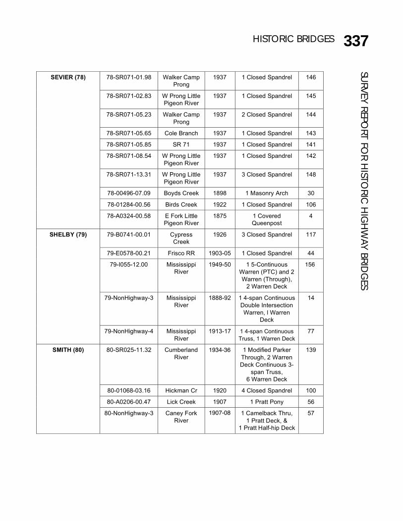
337HISTORIC BRIDGES
78-SR071-01.98 Walker Camp
Prong
1937 1 Closed Spandrel 146
78-SR071-02.83 W Prong Little
Pigeon River
1937 1 Closed Spandrel 145
78-SR071-05.23 Walker Camp
Prong
1937 2 Closed Spandrel 144
78-SR071-05.65 Cole Branch 1937 1 Closed Spandrel 143
78-SR071-05.85 SR 71 1937 1 Closed Spandrel 141
78-SR071-08.54 W Prong Little
Pigeon River
1937 1 Closed Spandrel 142
78-SR071-13.31 W Prong Little
Pigeon River
1937 3 Closed Spandrel 148
78-00496-07.09 Boyds Creek 1898 1 Masonry Arch 30
78-01284-00.56 Birds Creek 1922 1 Closed Spandrel 106
SEVIER (78)
78-A0324-00.58 E Fork Little
Pigeon River
1875 1 Covered
Queenpost
4
79-B0741-00.01 Cypress
Creek
1926 3 Closed Spandrel 117
79-E0578-00.21 Frisco RR 1903-05 1 Closed Spandrel 44
79-I055-12.00 Mississippi
River
1949-50 1 5-Continuous
Warren (PTC) and 2
Warren (Through),
2 Warren Deck
155
79-NonHighway-3 Mississippi
River
1888-92 1 4-span Continuous
Double Intersection
Warren, l Warren
Deck
14
SHELBY (79)
79-NonHighway-4 Mississippi
River
1913-17 1 4-span Continuous
Truss, 1 Warren Deck
77
80-SR025-11.32 Cumberland
River
1934-
1936
1 Modified Parker
Through, 2 Warren
Deck Continuous 3-
span Truss,
6 Warren Deck
139
80-01068-03.16 Hickman Cr 1920 4 Closed Spandrel 100
80-A0206-00.47 Lick Creek 1907 1 Pratt Pony 56
SMITH (80)
80-NonHighway-3 Caney Fork
River
1907-
1908
1 Camelback Thru,
1 Pratt Deck, &
1 Pratt Half-hip Deck
57
1934-36
1907-08
156
SURVEY REPO
RT FOR H
ISTORIC
HIG
HW
AY BRIDG
ES

338 HISTORIC BRIDGES
81-A0330-01.41 Standing Rock
Creek
1929 1 Open Spandrel 128 STEWART (81)
81-NonHighway-2 S Cross Creek 1902 1 Pratt Through 38
82-SR036-05.01 Holston River 1929-30 3 Open Spandrel 131
82-A0872-00.05 South Fork
Holston River
1902-03 1 Camelback &
1 Pratt Through
39
82-C0539-00.01 S F Holston Rv 1913 3 Pratt Through 75
SULLIVAN (82)
82-NonHighway-1 Beaver Creek 1898 1 Pratt Through 31
83-A0884-00.35 Slaters Creek ca. 1841 1 Masonry Arch 3
83-NonHighway-1 Caney Fork Cr 1913 1 Warren-PTC Pony 76
SUMNER (83)
83-NonHighway-4 Dry Fork
Creek
1900 ca 1 Double Intersection
Warren Pony
34
TIPTON (84) NONE
TROUSDALE (85) NONE
UNICOI (86) 86-A0068-00.89 Nolichucky Rv 1916 5 Closed Spandrel 89
UNION (87) 87-SR033-15.83 Clinch River 1934-36 2 2-span Continuous
Warren-PTC Thru
140
VAN BUREN (88) 88-NonHighway-1 Cane Creek 1908;
1924
1 Pratt Through,
1 Warren Pony
61
89-04261-11.60 Collins River 1924;
1889
2 Parker Through,
2 Warren Pony
112 WARREN (89)
89-A0278-00.31 Rocky River 1922-23 1 Open Spandrel 107
90-A0900-00.97 Nolichucky
River
1901-02 2 Pratt Through,
1 Pratt Pony
36 WASHINGTON (90)
90-B0586-00.00 Watauga Rv 1916 2 Penn Petit Thru 90
WAYNE (91) NONE
WEAKLEY (92) NONE
93-A0285-00.95 Lost Creek 1912 1 Pratt Pony 73 WHITE (93)
93-A0415-00.19 L & N Railroad 1917-
1918
1 Queenpost Pony 96
WILLIAMSON (94) NONE
95-02036-01. 51 Round Lick Cr 1921 2 Closed Spandrel 103 WILSON (95)
95-A0392-02.12 Fall Creek 1928 3 Closed Spandrel-
Ribbed
124
1917-18
SURV
EY R
EPO
RT F
OR
HIS
TORI
C H
IGH
WAY
BRI
DG
ES

339HISTORIC BRIDGES
1830-1901 PERIOD
The first of these periods generally covers from about 1830, the approximate constructiondate of the oldest bridge included in this survey, until the turn of the twentieth century. About1900, bridge building patterns in the state changed due to floods that destroyed numerousbridges and due to the demise of several older bridge companies and the formation of newcompanies. Bridges from the nineteenth century reflect both traditional designs in masonryand timber as well as experimental designs in what was then the new field of metal trussdesign.
The oldest bridges in the survey, and the only ones dating from before the Civil War, are themasonry arch spans from the Louisville and Nashville Turnpike (#1, 19-E0224-00.07; #2, 4-NonHighway-1; and #3, 83-A0884-00.35). These bridges reflect traditional bridgebuilding techniques. Counties also built covered wooden truss bridges, such as the HarrisburgCovered Bridge (#4, 78-A0324-00.58), and the Elizabethton Covered Bridge (#8, 10-A0398-00.01), another traditional bridge form.
However, from the 1870s until about 1901, a plethora of bridge companies flourished aroundthe country. In an effort to distinguish themselves from other companies, many firmsexperimented with truss designs and specific components. The Dobbs Ford Bridge (#5, 06-A0184-00.64) represents an early use of the then relatively new Pratt truss. The SycamoreMills Bridge (#22, 11-NonHighway-1, a fixed cable stayed suspension bridge) was a creativeexperiment. The Kelso Bridge (#6, 52-A0183-05.54, a patented Whipple truss) and the StoneBluff Bridge (#17, 52-A0487-04.85, a Double Intersection Pratt) feature truss designs that themore efficient Parker or Camelback designs soon replaced. The Dobbs Ford Bridge (#5, 06-A0184-00.64), the Kelso Bridge (#6, 52-A0183-05.54), and the Sulphur Fork Bridge (#21, 63-A0456-01.88) contain connections or members that are patented or based on patents;features that standard factory produced members soon rendered obsolete.
SURVEY REPO
RT FOR H
ISTORIC
HIG
HW
AY BRIDG
ES

340 HISTORIC BRIDGESSU
RVEY
REP
ORT
FO
R H
ISTO
RIC
HIG
HW
AY B
RID
GES (#1) 19-E0224-00.07: Old Stone Bridge spanning Manskers Creek in Goodlettsville on the
Davidson Sumner County line (#2) 74-NonHighway-1: Cheek Stand Bridge spanning the Red River in northeast RobertsonCounty(#3) 83-A0884-00.35: Turnpike Bridge spanning Slaters Creek in Goodlettsville, SumnerCounty
Significant under Criterion A for their associations with the turnpike era and under CriterionC as rare early masonry arch bridges
These three masonry arch bridges are located on the original route of the old Louisville toNashville Turnpike. Although not incorporated as a turnpike until the 1830s, this routefollowed old, animal and Indian trails that had become a wagon road at least by the 1790s. Thisturnpike was quite prosperous until the 1850s when the completion of the Louisville toNashville Railroad provided an alternative transportation corridor. However, portions of itcontinued as a turnpike until about 1900, and the road has continued to be a major overlandtransportation route. The state designated much of the route as State Route 41/U.S. 31W inthe 1920s. As the state improved these systems in the 1920s and 1930s, the state built a newroute that bypassed many of the older sections. This realignment saved these bridges; oneremains open today on a little used city road, and two are located on farm roads.
The erection dates of these bridges are unknown, but local historians have estimated theywere built between 1825 and 1850. Oral interviews of local residents along the turnpike in1934 indicated that a mason named Johnson built them in 1841 (Dorsey 1935; Henderson1982; Henderson and Durrett 1979, Tretter 1986). Since all three bridges are relatively alike,it is assumed the same mason built them at about the same time. An interesting feature is thatall three are laid without mortar.

341HISTORIC BRIDGESSU
RVEY REPORT FO
R HISTO
RIC H
IGH
WAY BRID
GES
The Old Stone Bridge (19-E0224-00.07) contains two arch spans formed of cut stone laid ina coursed pattern. Each arch is 24.4 feet in length, and the total length is 89.5 feet. The curbto curb width is 19.5 feet, and the out to out width is 24.5 feet. A row of cut stones followsthe line of the elliptical arches to the spring line. The stone walls rest above the arches toform the bridge railing that runs the length of the bridge and flares out at each end. A singlerow of large rectangular stones tops the railing.
(#1) 19-E0224-00.07: Old Stone Bridge spanning Manskers Creek in Goodlettsville on theDavidson Sumner County line (Goodlettsville Quad, 310 SW).

342 HISTORIC BRIDGESSU
RVEY
REP
ORT
FO
R H
ISTO
RIC
HIG
HW
AY B
RID
GES
The Cheek Stand Bridge (74-NonHighway-1) spans the Red River on a farm road within theCheek Stand property. Cheek Stand, a tavern and stage coach stop on the Old Louisville toNashville Turnpike, presently consists of an 1838 log house (called Rock Rest), an 1847 threestory stage coach (banked) stable, a log smokehouse, a stone spring house, and the bridge andstone fences lining the roadway. The bridge consists of two spans, each 23.0 feet in length. Theoverall length is 78.0 feet. The curb to curb width is 18.0 feet, and the out to out width is 21.0feet. A row of cut stones follows the line of the elliptical arches. The cut, coursed stone wallsrise above the arches to form railings that run the length of the bridge. The downstreamrailing has partially collapsed.
(#2) 74-NonHighway-1: Cheek Stand Bridge spanning the Red River innortheast Robertson County (Portland Quad, 309 SE).

343HISTORIC BRIDGESSU
RVEY REPORT FO
R HISTO
RIC H
IGH
WAY BRID
GES
The Slaters Creek Bridge (83-A0884-00.55) spans Slaters Creek on a farm road near the siteof Isaac Walton’s tavern. For many years the county road ended at the bridge, but in 1985 thecounty removed this bridge from the public road system and its ownership reverted to theadjacent property owner. The bridge consists of one 25 foot arch span formed of cut stonelaid in a coursed pattern. The curb to curb width is 21.1 feet, and the out to out width is 24.1feet. A row of cut stones follows the line of the low set elliptical arch. The stone walls riseabove the arches to form a low curb like bridge railing that runs the length of the bridge andflares out at each end. A single row of large rectangular stones tops the railing.
(#3) 83-A0884-00.35: Turnpike Bridge spanning Slaters Creek in Goodlettsville,Sumner County (Goodlettsville Quad, 310 SW).

344 HISTORIC BRIDGESSU
RVEY
REP
ORT
FO
R H
ISTO
RIC
HIG
HW
AY B
RID
GES (#4) 78-A0324-00.58: Harrisburg Covered Bridge spanning the East Fork of the
Little Pigeon River east of Sevierville in north central Sevier County (RichardsonCove Quad, 164 SW).
Significant under Criterion C as a rare covered timber truss bridge.
The community of Harrisburg has contained a bridge at this location since the mid-1800s.Known as the McNutts Bridge, it washed away in 1875. In March of that same year, the SevierCounty Court appointed a committee of J.H. Frame, A.E. Murphy, and D.W. Howard to overseethe rebuilding of the bridge. As was common then, local citizens contributed to the replacementof the bridge. Although only $50 could be privately raised, the Harrisburg community providedthe wood and labor for the replacement structure. The county donated $25.

345HISTORIC BRIDGESSU
RVEY REPORT FO
R HISTO
RIC H
IGH
WAY BRID
GES
The county hired Elbert Stephenson Early to build a covered bridge. Elbert Early (1850-1917),along with several members of his family, moved to the Harrisburg area of Sevier County inthe 1870s. Several members of the Early family were skilled carpenters, millwrights, andengineers. They built Murphy Chapel and several residences in the area. In 1877, Elbert Earlypurchased half interest in the Newport Mill, adjacent to the Harrisburg Covered Bridge, fromAlexander Umbarger, a relative of his wife, Clementine (1843-1922).
In the late 1800s, the Harrisburg community grew, and with its several mills, blacksmith shops,a school, a doctor, and a post office, prospered. However, in 1915 the county built a new roadthat bypassed Harrisburg and the community disappeared.
In 1952, a county road crew stabilized the bridge which included the placement of a concretepier at the center of the truss. As a result, this span functioned as two timber stringers. Bythe 1970s, the bridge was deteriorated and facing possible demolition when the GreatSmokies Chapter and the Spencer Clack Chapter of the Daughters of the AmericanRevolution (DAR) raised funds to repair and maintain the bridge as well as seeking listing forit on the National Register of Historic Places. The Harrisburg Covered Bridge was listed inthe National Register of Historic Places in 1975 for its significance as a rare surviving exampleof a covered timber truss bridge.
In 1983, the bridge had deteriorated and again faced closure, but the county renovated thebridge with new flooring and replaced some of the timber beams, allowing the bridge toremain open but posted it with a 3-ton weight limit.
The bridge, which is 83 feet long, contains a 64-foot timber Queenpost pony truss and an 18-foot steel I-beam span. A covered structure topped with a gable tin roof encases the trusssection. The bridge has a curb-to-curb width of 11.4 feet and an out-to-out width of 14.1 feet.
Through a grant from the National Historic Covered Bridge Preservation Program throughthe Federal Highway Administration and TDOT, Sevier County rehabilitated the HarrisburgCovered Bridge, extensively repairing the bridge in 2004. It was reopened for traffic, with a15-ton weight limit, on 2 December 2004.
346 HISTORIC BRIDGESSU
RVEY
REP
ORT
FO
R H
ISTO
RIC
HIG
HW
AY B
RID
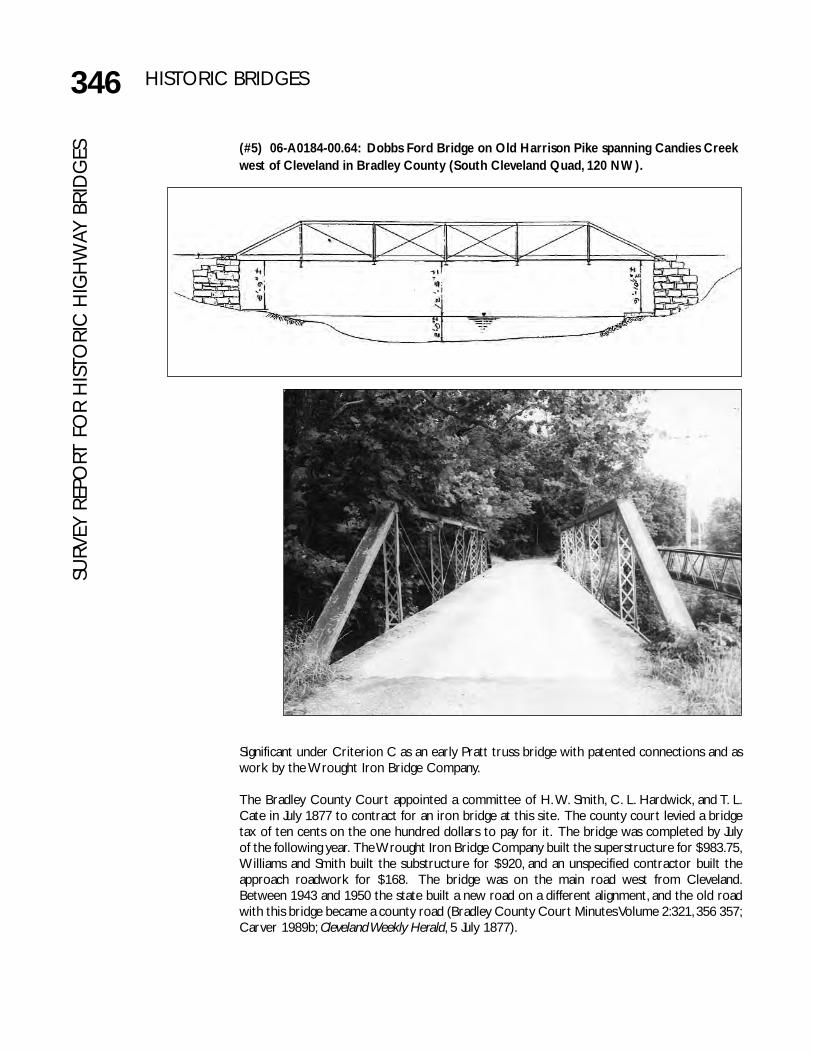
GES (#5) 06-A0184-00.64: Dobbs Ford Bridge on Old Harrison Pike spanning Candies Creek
west of Cleveland in Bradley County (South Cleveland Quad, 120 NW).
Significant under Criterion C as an early Pratt truss bridge with patented connections and aswork by the Wrought Iron Bridge Company.
The Bradley County Court appointed a committee of H. W. Smith, C. L. Hardwick, and T. L.Cate in July 1877 to contract for an iron bridge at this site. The county court levied a bridgetax of ten cents on the one hundred dollars to pay for it. The bridge was completed by Julyof the following year. The Wrought Iron Bridge Company built the superstructure for $983.75,Williams and Smith built the substructure for $920, and an unspecified contractor built theapproach roadwork for $168. The bridge was on the main road west from Cleveland.Between 1943 and 1950 the state built a new road on a different alignment, and the old roadwith this bridge became a county road (Bradley County Court Minutes Volume 2:321, 356 357;Carver 1989b; Cleveland Weekly Herald, 5 July 1877).
347HISTORIC BRIDGESSU
RVEY REPORT FO
R HISTO
RIC H
IGH
WAY BRID
GES
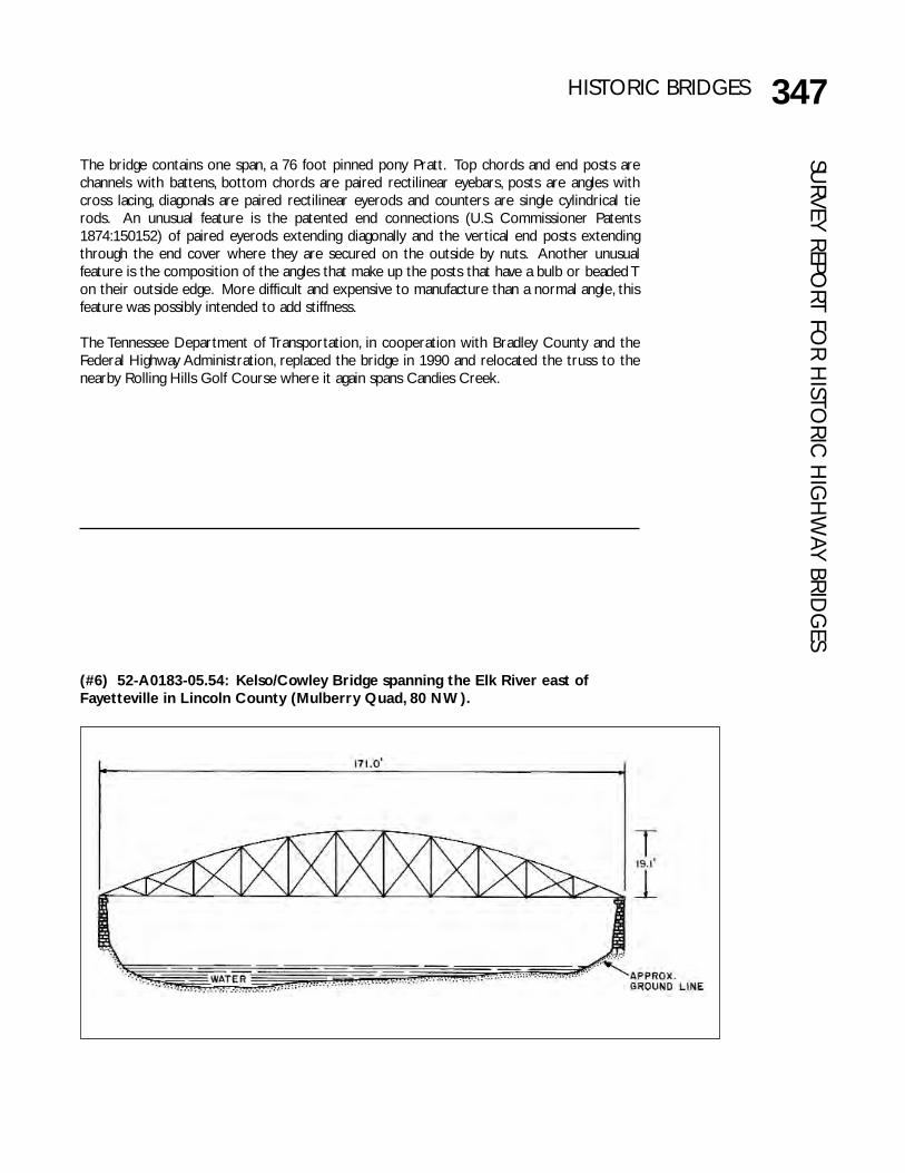
(#6) 52-A0183-05.54: Kelso/Cowley Bridge spanning the Elk River east ofFayetteville in Lincoln County (Mulberry Quad, 80 NW).
The bridge contains one span, a 76 foot pinned pony Pratt. Top chords and end posts arechannels with battens, bottom chords are paired rectilinear eyebars, posts are angles withcross lacing, diagonals are paired rectilinear eyerods and counters are single cylindrical tierods. An unusual feature is the patented end connections (U.S. Commissioner Patents1874:150152) of paired eyerods extending diagonally and the vertical end posts extendingthrough the end cover where they are secured on the outside by nuts. Another unusualfeature is the composition of the angles that make up the posts that have a bulb or beaded Ton their outside edge. More difficult and expensive to manufacture than a normal angle, thisfeature was possibly intended to add stiffness.
The Tennessee Department of Transportation, in cooperation with Bradley County and theFederal Highway Administration, replaced the bridge in 1990 and relocated the truss to thenearby Rolling Hills Golf Course where it again spans Candies Creek.

Significant under Criterion C as the only Bowstring truss in the state, for its patented features,and as rare surviving work of the King Iron Bridge Company.
The nationally famous King Iron Bridge Company built this bridge, the only Bowstring truss inthe state, in 1878 for $8,000 (Fielder 1983; Lincoln County Court Minutes Book A-1:611-614,246-248). The bridge contains one span, a patented Bowstring tubular arch through truss thatis 170.5 feet long sitting on masonry abutments. The superstructure contains portal plaquesidentifying the builder as the King Iron Bridge Company, and a small oval plaque on the topchord lists the patent date as 30 July 1867. The substructure contains a plaque that gives theerection date and names of the masons, an unusual feature.
As a patented design, the connections and composition of the members are quite differentfrom those found on most truss bridges. The top chord is tubular rather than being formedof channels with lacing. Bottom chords are paired eyebars that become circular in shape asthey pass through a plate at the abutment where they are threaded and secured by nuts onthe outside. The verticals are right angles with lacing but are unique in that they flatten andflare near the floor and then become circular rods that are bolted into the floor beams. Thefloor beams themselves are lightweight and have inverted trussed bracing. Top and bottomlateral bracing consist of four short rods attached to a circular member in the center ratherthan the typical paired rods that extend diagonally across the full panel. Unusually long, thetruss is 13.8 feet wide with a minimum vertical clearance of 14.5 feet and an overall height of19.1 feet. The panels in most truss bridges are the same length, but in this bridge the centerpanel is 17.5 feet while the others are only 15.2 feet long.
In the 1980s Lincoln County built a new bridge nearby that rendered this bridge and a shortroad section redundant. The bridge is now closed to traffic but remains intact.
348 HISTORIC BRIDGESSU
RVEY
REP
ORT
FO
R H
ISTO
RIC
HIG
HW
AY B
RID
GES
349HISTORIC BRIDGESSU
RVEY REPORT FO
R HISTO
RIC H
IGH
WAY BRID
GES
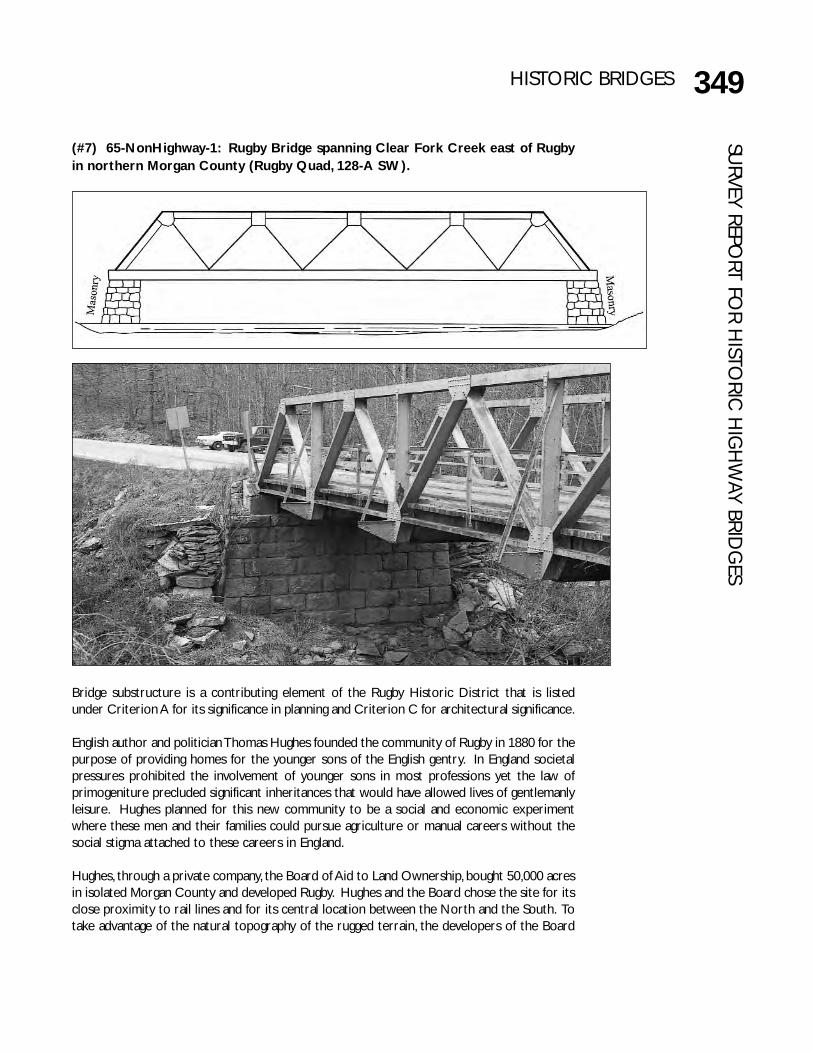
(#7) 65-NonHighway-1: Rugby Bridge spanning Clear Fork Creek east of Rugbyin northern Morgan County (Rugby Quad, 128-A SW).
Bridge substructure is a contributing element of the Rugby Historic District that is listedunder Criterion A for its significance in planning and Criterion C for architectural significance.
English author and politician Thomas Hughes founded the community of Rugby in 1880 for thepurpose of providing homes for the younger sons of the English gentry. In England societalpressures prohibited the involvement of younger sons in most professions yet the law ofprimogeniture precluded significant inheritances that would have allowed lives of gentlemanlyleisure. Hughes planned for this new community to be a social and economic experimentwhere these men and their families could pursue agriculture or manual careers without thesocial stigma attached to these careers in England.
Hughes, through a private company, the Board of Aid to Land Ownership, bought 50,000 acresin isolated Morgan County and developed Rugby. Hughes and the Board chose the site for itsclose proximity to rail lines and for its central location between the North and the South. Totake advantage of the natural topography of the rugged terrain, the developers of the Board

350 HISTORIC BRIDGESSU
RVEY
REP
ORT
FO
R H
ISTO
RIC
HIG
HW
AY B
RID
GES
(#8) 10-A0398-00.01: Elizabethton Covered Bridge spanning the Doe River inElizabethton, Carter County (Elizabethton Quad, 207 SW).
of Aid incorporated creative ideas in English and American town planning into Rugby’s designthat resulted in European asymmetrical street patterns and open vistas combined with thetraditional American grid pattern.
The residents settled only about 1,500 acres to any extent, and creeks bounded this area onall sides. Within this area, they built 77 major buildings of which 20 remain. These buildingsrepresent a superb collection of picturesque Victorian architecture. A circa 1880 toll bridgecomposed of a wood and iron Howe through truss marked the entrance to Rugby on theRugby-Sedgemoor Road over White Oak Creek. The substructure for the bridge consisted ofone sandstone boulder and a coursed sandstone block abutment. At an undetermined date,estimated to be about 1920, the Howe truss was removed and a steel Warren truss waserected on top of the 1880 substructure. The Rugby Colony with 525 acres was listed in theNational Register in 1972, and a determination of eligibility in 1981 expanded the boundariesto 1,546 acres. Although the Warren truss itself does not contribute to the Rugby ColonyHistoric District, the substructure is a contributing element (Nolen 1981; Stagg 1972).
In 1981 the state built a new bridge nearby and closed the existing bridge to traffic. The oldbridge is now part of a scenic pull off.

351HISTORIC BRIDGESSU
RVEY REPORT FO
R HISTO
RIC H
IGH
WAY BRID
GES
Significant under Criterion C as a rare covered timber truss bridge.
The Elizabethton Covered Bridge is located in downtown Elizabethton, the county seat of CarterCounty. Much of the downtown is listed in the National Register under Criteria A and C. TheElizabethton Historic District contains a variety of properties ranging in age from the late 1700sthrough the 1930s (Beasley 1972). The bridge is a well-known landmark in the state and thecenterpiece of an annual festival in Elizabethton. In addition to this bridge, the district alsocontains a significant 1926 concrete arch bridge over the Doe River (#115, 10-03939-00.10).
Carter County erected this bridge in 1882 for $3,300. After the county was unable to find abridge builder to erect the bridge, a local doctor named E. E. Hunter accepted the contract andhired experienced individuals to work on the bridge such as Hunter selected Thomas Matson,who had been an engineer for the Narrow Gauge (Tweetsie) Railroad. Hunter referred to thebridge as his “$5 Bridge” since he made a profit of $5 as contractor. This was the only majorbridge in the area to survive the disastrous 1901 flood, although it was battered by floodwaters,logs from a nearby lumber operation, and even a barn that smashed into it (Crowe 1977).
The bridge contains one span, a covered wooden Howe truss 137 feet long. The total length is154.3 feet. The bridge contains one traffic lane and one sidewalk. The curb-to-curb width is 16.4feet, and the out to out width is 20.4 feet. The substructure is masonry stone and concrete. Eachend of the bridge features a projecting truncated gabled roofline described in this manner by onebridge historian:
It is singular in appearance for an American covered bridge, resembling greatlythose of Switzerland, Bavaria and New Brunswick, Canada. At each end greatdiagonal shelter panels protrude, and a sloping triangular roof comes down fromthe ridgepole to top them (Allen 1970:28).
The Elizabethton Covered Bridge received a Transportation Enhancement grant for rehabilitationin 2002 and was rehabilitated in 2003-04 and is now open for traffic.
352 HISTORIC BRIDGESSU
RVEY
REP
ORT
FO
R H
ISTO
RIC
HIG
HW
AY B
RID
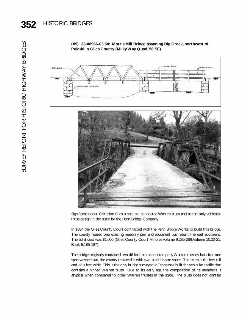
GES (#9) 28-00966-03.54: Morris Mill Bridge spanning Big Creek, northwest of
Pulaski in Giles County (Milky Way Quad, 58 SE).
Significant under Criterion C as a rare pin connected Warren truss and as the only vehiculartruss design in the state by the Penn Bridge Company.
In 1884 the Giles County Court contracted with the Penn Bridge Works to build this bridge.The county reused one existing masonry pier and abutment but rebuilt the east abutment.The total cost was $1,000 (Giles County Court Minutes Volume 9:285-286; Volume 10:20-21;Book 5:185-187).
The bridge originally contained two 46 foot pin connected pony Warren trusses, but after onespan washed out, the county replaced it with two steel I beam spans. The truss is 6.1 feet talland 12.0 feet wide. This is the only bridge surveyed in Tennessee built for vehicular traffic thatcontains a pinned Warren truss. Due to its early age, the composition of its members isatypical when compared to other Warren trusses in the state. The truss does not contain

353HISTORIC BRIDGESSU
RVEY REPORT FO
R HISTO
RIC H
IGH
WAY BRID
GES
(#10) 61-A0022-01.04: King’s Mill Bridge spanning Sewee Creek north ofDecatur in Northeast Meigs County (Decatur Quad, 118 SE).
verticals. The top chords and end posts are channels connected with lacing on the top andbottom, except the mid panel that has a channel on top. The diagonals are paired angles withlacing, except the hip diagonals which are paired rectilinear eyerods. Rectilinear eyebars formthe bottom chords.
In the early 1980s Giles County built a new bridge nearby that rendered this bridge and ashort road segment redundant. In 1984 the county, through local courts, transferredownership of the road and bridge to adjacent property owners. The road is now closed totraffic but the bridge remains intact.

354 HISTORIC BRIDGESSU
RVEY
REP
ORT
FO
R H
ISTO
RIC
HIG
HW
AY B
RID
GES
Significant under Criterion C as an early, atypical Pratt truss bridge by the Champion BridgeCompany.
In April 1884 the Meigs County Court ordered that a contract be entered into with theChampion Bridge Company for $1,395 to erect the superstructure of this bridge. It is unclearif the substructure predates the truss or if the county contracted for it separately. Apparently,Champion completed the bridge by October since the court at that time ordered all warrantsregarding the bridge to be paid (Meigs County Court Minutes Volume 9:63, 114, 318; Toplovichand Rogers 1981).
The King’s Mill Bridge contains one span, an iron 98.5-foot pin connected Pratt through trusssitting on masonry abutments. The bridge has a curb-to-curb width of 11.1 feet and an out-to-out width of 13.0 feet. Decorative features include lattice portal bracing, arched kneebracing with a single circle, and four finials. The composition of most members is relativelytypical. Top chords and end posts are channels with battens. Bottom chords and diagonalsare paired rectilinear eyebars. Verticals are small channels with lacing, except the hip verticals,which are paired rectilinear eyerods. Counters are single cylindrical tie rods. One unusualfeature is the lateral bracing that connects at an angle on the side of the end post thatconnects near but not within the intersection of the strut and vertical. Another unusualfeature is a horizontal tension member that spans the two center panels and then extendsdiagonally upward and joins the upper chord at its intersection with the hip length; at thosepoints a circular metal piece is located in the vertical, and the tension member is bolted intoeach side. Apparently the additional tension member was not a cost efficient design and fewexamples remain.

355HISTORIC BRIDGESSU
RVEY REPORT FO
R HISTO
RIC H
IGH
WAY BRID
GES
(#11) 76-A0040-08.03: Old O & W Bridge spanning Big South Fork Riversouthwest of Oneida in western Scott County; within Big South Fork NationalRiver and Recreation Area (Honey Creek Quad, 128-A NW).
Significant under Criterion C as a rare surviving example of the Whipple truss.
The original date and place of the erection of the main span of this bridge are unknown butit is estimated to have been fabricated in the 1880s. In 1914 the Nashville Bridge Companyrelocated it to this site on the Oneida and Western Railroad that was then underconstruction. This line primarily served local lumber and coal industries. After the rail lineabandoned the roadbed with its bridges intact in 1954, the county acquired it in 1956 andconverted it to a county road. This bridge is considered a local landmark, in part, due to itsspectacular location high above the Big South Fork River gorge. It is located on a trail withinthe Big South Fork National Recreation Area (Hutchinson et al. 1982:5-26; Nashville BridgeCompany #3611; Sulzer 1975:187-197).

Significant under Criterion C as representative Pratt pony trusses, for their patentedconnections, and as work by the Wrought Iron Bridge Company.
356 HISTORIC BRIDGESSU
RVEY
REP
ORT
FO
R H
ISTO
RIC
HIG
HW
AY B
RID
GES The 344 foot bridge contains one truss span, three plate girders, and one steel stringer. The
approaches are steel frames on concrete pads. The eastern abutment is concrete and thewestern abutment is a massive boulder. The bridge has a curb-to-curb width of 8.4 feet andan out-to-out width of 15.5 feet. The main span is a 201.5 foot pin-connected DoubleIntersection Pratt/Whipple through truss that is 31 feet tall. Composition of members istypical. Top chords and end posts are channels with lacing, bottom chords are paired orquadrupled rectilinear eyebars, verticals are small channels with lacing, diagonals are pairedrectilinear eyebars, and counters are single rectilinear tie rods. The only decorative feature isa single circle within the knee bracing.
(#12) 06-A0163-00.19: Lea Bridge on Old Georgetown Road spanning CandiesCreek northwest of Cleveland in Bradley County (South Cleveland Quad, 120 NW).

357HISTORIC BRIDGESSU
RVEY REPORT FO
R HISTO
RIC H
IGH
WAY BRID
GES
In October 1885 the Bradley County Court appointed a three-man committee to investigatebuilding a bridge across Candy’s (Candies) Creek. In January 1886 the court agreed to buildthe bridge and in April the committee reported it had been completed at a cost of $2,000.This bridge was on the main road between Cleveland and Dayton that became State Route83 in the 1920s. The state renumbered the road as State Route 60 in 1940 and rebuilt it inthe late 1940s. At that time, the new alignment bypassed this bridge with a short road segmentand it became a local road (Bradley County Court Minutes Volume 3:212, 250, 252, 266; Carver1986a).
The Wrought Iron Bridge Company, whose agent was W. H. Converse, built the three-spanbridge. Each span is an iron Pratt pony truss. The main span is 63 feet long and the secondaryspans are 44 feet long. Sitting on a masonry substructure, the middle span is 7.0 feet tall andeach flanking span is 5.0 feet tall. The curb to curb width is 11.3 feet, and the out to out widthis 13.0 feet. Composition of the members is similar to that on the 1877 78 Dobbs Ford Bridge(#5, 06-A0184-00.64) as are the patented connections and “beaded T” angles. Top chords andend posts are channels with battens, bottom chords are paired rectilinear eyebars, posts areangles with cross lacing, diagonals are paired rectilinear eyerods and counters are singlecylindrical tie rods. An unusual feature is the patented end connections (U.S. CommissionerPatents 1874:150152) of paired eyerods extending diagonally and the vertical end postsextending through the end cover where they are secured on the outside by nuts. Anotherunusual feature is the composition of the angles that make up the posts that have a bulb orbeaded T on their outside edge. More difficult and expensive to manufacture than a normalangle, this feature was possibly intended to add stiffness.
The Tennessee Department of Transportation, in cooperation with Bradley County and theFederal Highway Administration, replaced this bridge in 1988 and relocated the truss spans toa Cleveland city park. The city later gave the main span to the city of Collegedale for use onits greenway.

358 HISTORIC BRIDGESSU
RVEY
REP
ORT
FO
R H
ISTO
RIC
HIG
HW
AY B
RID
GES (#13) 19-NonHighway-8: Lebanon Road Bridge spanning Browns Creek
southeast of Nashville in Davidson County (Nashville East Quad 311 NW).
Significant under Criterion A for its associations with Nashville’s public water system andunder Criterion C as rare masonry arch with unusual brick lining.
In 1888 the City of Nashville assigned Nashville City Engineer J. A. Jowett the task of designingthis bridge and hired the Foster Creighton Company to erect it. The bridge was onecomponent of an effort to improve the city’s municipal water-works system. Although theprimary purpose of this bridge was to carry a 36 inch water main across Browns Creek, thusconnecting the Omohundro Water Filtration Complex with the Eighth Avenue SouthReservoir, it also carried Lebanon Road traffic. The state built a new structure nearby in 1925and removed traffic from this bridge. However, the old bridge continues to carry the 36 inchwater main across Browns Creek to the Reservoir (Sturtevant 1986a).
The bridge contains one span, a masonry arch 48 feet long. The curb-to-curb width is 20.1feet, and the out-to-out width is 25.0 feet. The structure is primarily composed of largerectangular rough coursed limestone blocks of varying sizes. An unusual feature is that thearch is lined with eight courses of common bond brick. The stone sides of the bridge continueabove the level of the roadbed to form railings running the length of the bridge.
359HISTORIC BRIDGESSU
RVEY REPORT FO
R HISTO
RIC H
IGH
WAY BRID
GES
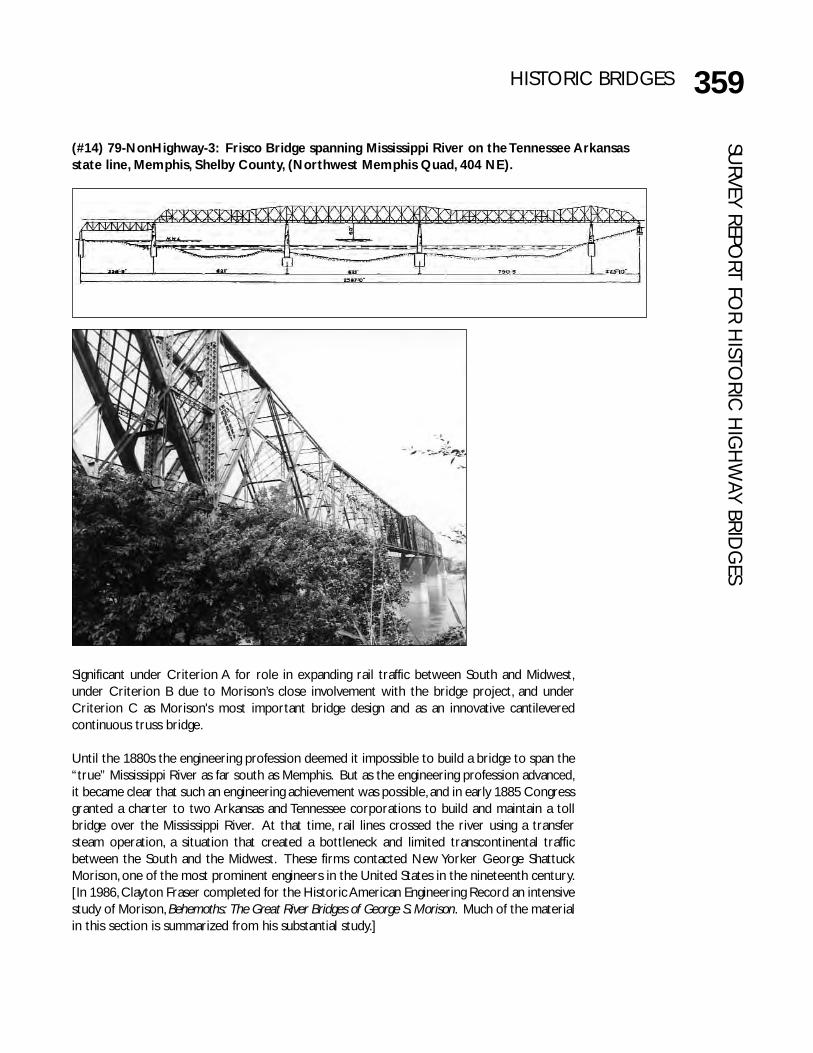
(#14) 79-NonHighway-3: Frisco Bridge spanning Mississippi River on the Tennessee Arkansasstate line, Memphis, Shelby County, (Northwest Memphis Quad, 404 NE).
Significant under Criterion A for role in expanding rail traffic between South and Midwest,under Criterion B due to Morison’s close involvement with the bridge project, and underCriterion C as Morison's most important bridge design and as an innovative cantileveredcontinuous truss bridge.
Until the 1880s the engineering profession deemed it impossible to build a bridge to span the“true” Mississippi River as far south as Memphis. But as the engineering profession advanced,it became clear that such an engineering achievement was possible, and in early 1885 Congressgranted a charter to two Arkansas and Tennessee corporations to build and maintain a tollbridge over the Mississippi River. At that time, rail lines crossed the river using a transfersteam operation, a situation that created a bottleneck and limited transcontinental trafficbetween the South and the Midwest. These firms contacted New Yorker George ShattuckMorison, one of the most prominent engineers in the United States in the nineteenth century.[In 1986, Clayton Fraser completed for the Historic American Engineering Record an intensivestudy of Morison, Behemoths: The Great River Bridges of George S. Morison. Much of the materialin this section is summarized from his substantial study.]

360 HISTORIC BRIDGESSU
RVEY
REP
ORT
FO
R H
ISTO
RIC
HIG
HW
AY B
RID
GES George Shattuck Morison, was born in 1843 in Massachusetts, the son of an eminent Unitarian
minister. Morison attended the prestigious preparatory school Phillips Exeter Academy andHarvard College and Harvard Law School. After receiving a Bachelor of Law degree in 1866and being admitted to the New York Bar, Morison began working with a New York law firm.Almost immediately Morison regretted his career choice but worked for nearly a year untilmaking a final decision to change professions. Morison had long been interested in civilengineering, and through the influence of family friends, railroad entrepreneur James F. Joyhired Morison to work under engineer Octave Chanute on the Kansas City Bridge spanningthe Missouri River. With no formal training in engineering, Chanute first assigned Morisonmenial tasks. However, Morison developed a study regimen, and as his natural abilities becameevident, Chanute gave him more challenging tasks and eventually appointed Morison assistantengineer for the project.
Through the mid-1870s Morison worked on different rail lines owned by Joy. In 1875 heformed his own consulting firm, Morison, Field and Company, and gradually built a nationalreputation. The reputation was based as much, if not more, on his managerial skills rather thanon his skills as an engineer. However, in 1880 Morison resigned from his firm to develop apractice based more on engineering design and decreased his participation in railroadoperations while focusing on bridge design.
Before his death in 1903, Morison had achieved national recognition for his truss designs,primarily for rail lines. He was extremely prolific and designed a variety of bridges of whichthe Frisco Bridge was considered his most outstanding design. Historian Carl Condit says ofthis bridge:
The cantilever truss reached its greatest size in the United States before the end ofthe century with the construction of the first Mississippi River bridge at Memphis,Tennessee…Its designing engineers, George S. Morison and Alfred Noble, were in thefront rank of their profession at the time, and they planned the structure on a heroicscale.
…After the Memphis bridge the cantilever spans erected during the remainder of thecentury seem anti-climatic” (Condit 1960:159-160).
One of the first major bridges to be built by Morison spanned the Genesee River at Portagee,New York, for the New York and Erie Railroad in 1875. In the 1880s Morison designed sevenWhipple-Murphy bridges spanning the Missouri River at Plattsmouth, Blair Crossing, Bismarck,Omaha, Nebraska City, Sioux City, and Rulo. In 1887-1889 he designed a Whipple-Murphytruss to span the Ohio River at Cairo for the Illinois Central. He also designed theBellefontaine Bridge, which contained a Baltimore Petit truss, and the 1890-1891 Swing Bridgeat Winona spanning the Mississippi River. Morison’s last design was also his only majorconcrete arch bridge, the Connecticut Avenue Bridge spanning Rock Creek in Washington,D.C. (Condit 1960, 1968; Fraser 1986; Plowden 1974).
When approached, Morison was at the peak of his career and quite interested in being thechief engineer for the first bridge to span the lower Mississippi River. Morison carefullyevaluated the Memphis area and selected a river crossing that he believed was the least likelyto be affected by shifting channels. However, he had reservations about the ability of theArkansas and Tennessee corporations to complete such an expensive and complicated project.

361HISTORIC BRIDGESSU
RVEY REPORT FO
R HISTO
RIC H
IGH
WAY BRID
GES
In January 1886, he approached George Nettleton, president of the Kansas City, Fort Scott toMemphis system of railroads to encourage him to finance and sponsor the bridge. Meanwhileopposition from the steamboat lobby blocked construction, and for various reasons, theprivate corporations dropped the project. In April 1888, Congress granted the railroad acharter but with a new stipulation—that the bridge also carry highway traffic. This newcharter also specified a 700 foot clear channel span (150 feet longer than in the 1884 charter)and a height of 75 feet (10 feet more than in 1884). This latter stipulation troubled Morisonthe most, and he argued vigorously to have it reduced but to no avail. Morison incorporatedthese new restrictions into his plans, and the Secretary of War approved them 25 August 1888.Construction began in October.
For this massive job, Morison chose a group of experienced assistants and contractors, manyof whom had worked with him previously. His three main assistants were Alfred Noble asresident engineer, M. A. Waldo as assistant engineer, and Ralph Modjeski who was chiefdraftsman and later chief inspector of the superstructure. (This was Modjeski's last job withhis mentor Morison and afterwards he too became a leading bridge engineer and was the chiefengineer of the 1913-1917 Harahan Bridge, #77, 79-NonHighway-4. Although Modjeskihimself died in 1940, his firm, Modjeski and Masters, would also design the 1949 Memphis andArkansas Bridge (#156, Memphis and Arkansas Bridge, 79-1055-12.00).
Between October 1888 and February 1889, workers completed the foundation. The piersrested on heavy timber caissons (92’ long x 47’ wide) which were founded on hard clay. Thedeepest foundations extended nearly 131 feet below the high water level and a maximumimmersion depth of 108 feet during construction, which was the second greatest depth at thattime in which the pneumatic process had been used. Men worked only three 45 minute shiftswithin a 24-hour period to guard against “caisson fever.” Even so, four died and the bends leftseveral others crippled.
Morison let the contract for the granite piers in April 1889 to Lewis Loss of New York. Lossfinished the piers in April 1891. During this period the only major disaster occurred when atowboat became lost in fog-like smoke from nearby factories and struck a partially completedbut still submerged pier. The impact destroyed the towboat, scattered the seven barges it wastowing, and killed six of the thirty-four people aboard.
On 24 January 1890, Morison awarded the contract for the fabrication of the superstructureto the Union Bridge Company. In May 1890 he awarded the contract to erect thesuperstructure to the Baird Brothers who had served as the erectors on most of Morison’smajor bridges. A notable feature of the trusses was that Morison chose to exclusively usesteel made in the open-hearth process that Carnegie, Phipps and Company (later CarnegieSteel) produced. Carnegie Steel shipped the uncut steel sections to the fabricator UnionBridge. Unfortunately, the scale of the project was more than Union (or probably any singlecompany) could handle, a problem compounded by Morison’s careful inspection and repeatedrejections of some of the steel, and Union fell behind schedule. As a result, eight othercompanies did about 36% of the fabrication work. However, due to the success of this bridge,Morison's specifications for the fabrication and erection of steel soon came to be therecognized standard for railroad bridges in this country. In March 1891 the last structuralcontract was awarded to the Pennsylvania Steel Company to manufacture the iron viaduct onthe west end.

362 HISTORIC BRIDGESSU
RVEY
REP
ORT
FO
R H
ISTO
RIC
HIG
HW
AY B
RID
GES Truss erection occurred between March 1891 and April 1892. Finishing touches included
laying the deck and final riveting. Tens of thousands took part in elaborate dedicationceremonies on 12 May 1892. Completion of the highway deck and viaduct delayed Morison’sofficially turning over the bridge to the railroad until 1 May 1893. The total cost was $3million. Morison was closely involved with the construction of this bridge, and many historiansconsider it Morison's greatest bridge design in his thirty-year career (Fraser 1986).
Known as the Frisco Bridge because the original rail companies later merged with the St. Louisand San Francisco Railroad (“Frisco Lines”), the bridge contains one 790-foot DoubleIntersection Warren (Lattice) continuous through truss with pinned connections. When built,it was the longest span in the United States and the third longest in the world. It wasMorison's desire to build three equal spans of 675 feet or to center the longest span, but theSecretary of War’s stipulations required that the main span be on the Tennessee side of theriver, which resulted in an asymmetrical truss arrangement. Thus (beginning on the east side),the bridge contains an anchorage span above land 225.9 feet long. The next span is the 790foot channel span. The next two truss spans are each 621 feet long. The last truss span is asimple deck Warren with verticals, a “mere” 339 feet long. West of the deck truss is a 2,290foot iron viaduct of plate girders supported by iron towers on concrete foundations. Thebridge contains a single rail track.
This is one of only a few bi-modal bridges in Tennessee, in this case for railroad and vehiculartraffic. The Congressional Charter for the bridge stipulated that the railroad would providean independent roadway for wagons and animals on each approach of said bridge, and, for theentire length of the bridge proper, a roadway of sufficient width for wagons to pass each otherwithout inconvenience, to be used by wagons and animals in common with the railroad. Thatsaid bridge shall be open for the passage of wagons and animals at all times except when trainsare actually passing.
However, it appears that wagon traffic did not widely use the bridge, in part due to the hightolls but also possibly due to its heavy usage by rail traffic. The steep design of the westernviaduct, which reputedly required multiple teams to pull a wagon up it, may have also been asignificant factor. By the early 1910s, when discussions began in earnest about the HarahanBridge (#77, 79-NonHighway-4), the Frisco Bridge had essentially ceased operating as a wagonroad bridge (Tennessee 1940:48). The bridge no longer carries vehicular traffic but is an activerailroad bridge and was pivotal in expanding rail traffic in this region. When completed, it wasthe only bridge to span the lower Mississippi River and had the longest span in the countryuntil 1917.
The American Society of Civil Engineers has designated three resources in Tennessee asNational Historic Civil Engineering Landmarks: the Montgomery Bell Tunnel, the Norris Dam,and the Frisco Bridge.
363HISTORIC BRIDGESSU
RVEY REPORT FO
R HISTO
RIC H
IGH
WAY BRID
GES
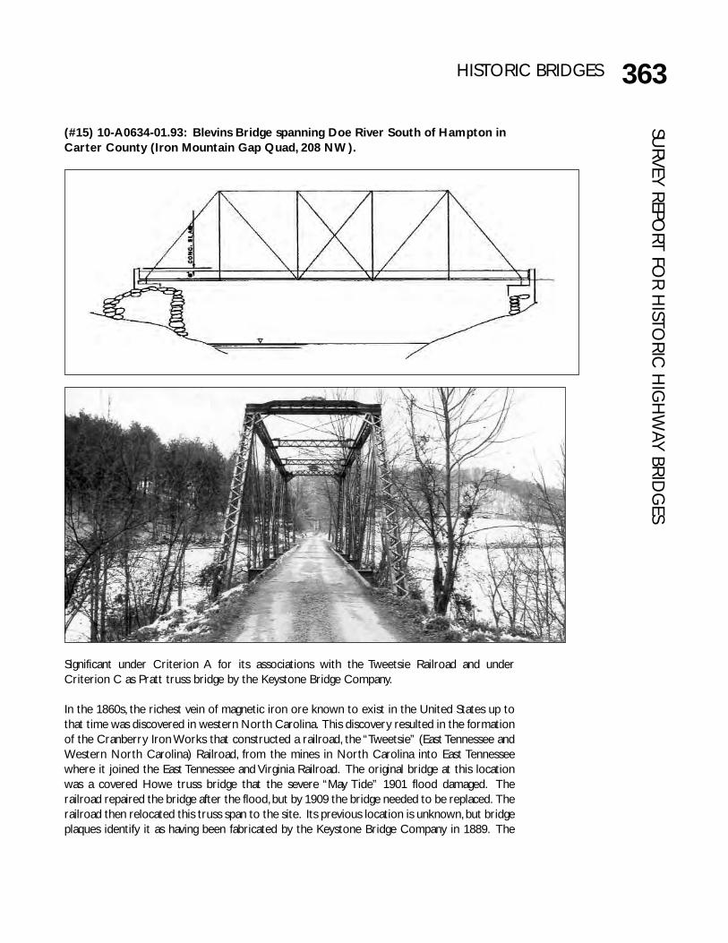
(#15) 10-A0634-01.93: Blevins Bridge spanning Doe River South of Hampton inCarter County (Iron Mountain Gap Quad, 208 NW).
Significant under Criterion A for its associations with the Tweetsie Railroad and underCriterion C as Pratt truss bridge by the Keystone Bridge Company.
In the 1860s, the richest vein of magnetic iron ore known to exist in the United States up tothat time was discovered in western North Carolina. This discovery resulted in the formationof the Cranberry Iron Works that constructed a railroad, the “Tweetsie” (East Tennessee andWestern North Carolina) Railroad, from the mines in North Carolina into East Tennesseewhere it joined the East Tennessee and Virginia Railroad. The original bridge at this locationwas a covered Howe truss bridge that the severe “May Tide” 1901 flood damaged. Therailroad repaired the bridge after the flood, but by 1909 the bridge needed to be replaced. Therailroad then relocated this truss span to the site. Its previous location is unknown, but bridgeplaques identify it as having been fabricated by the Keystone Bridge Company in 1889. The
364 HISTORIC BRIDGESSU
RVEY
REP
ORT
FO
R H
ISTO
RIC
HIG
HW
AY B
RID
GES Tweetsie Railroad abandoned a large segment of the line in Carter County in 1950. In 1967
the county opened a short segment, which included this bridge, for vehicular traffic (Bradshaw1942:37-39; ET&WNCRR April May 1993:8-11,16; Ferrell 1976; Sulzer 1975:85- 122).
The bridge contains one span, a pinned Pratt through truss 111 feet long and 24.9 feet tall.Top chords and end posts are channels with lacing on the top and bottom. Bottom chords,which lie below the floor beam, are paired rectilinear eyebars. Verticals are channels withlacing, except the hip verticals, which are paired rectilinear eyebars as are the diagonals. Thecounters are paired rectilinear tie rods. The truss rests on masonry abutments, probablyerected in 1882, which have concrete caps, possibly added in 1909.
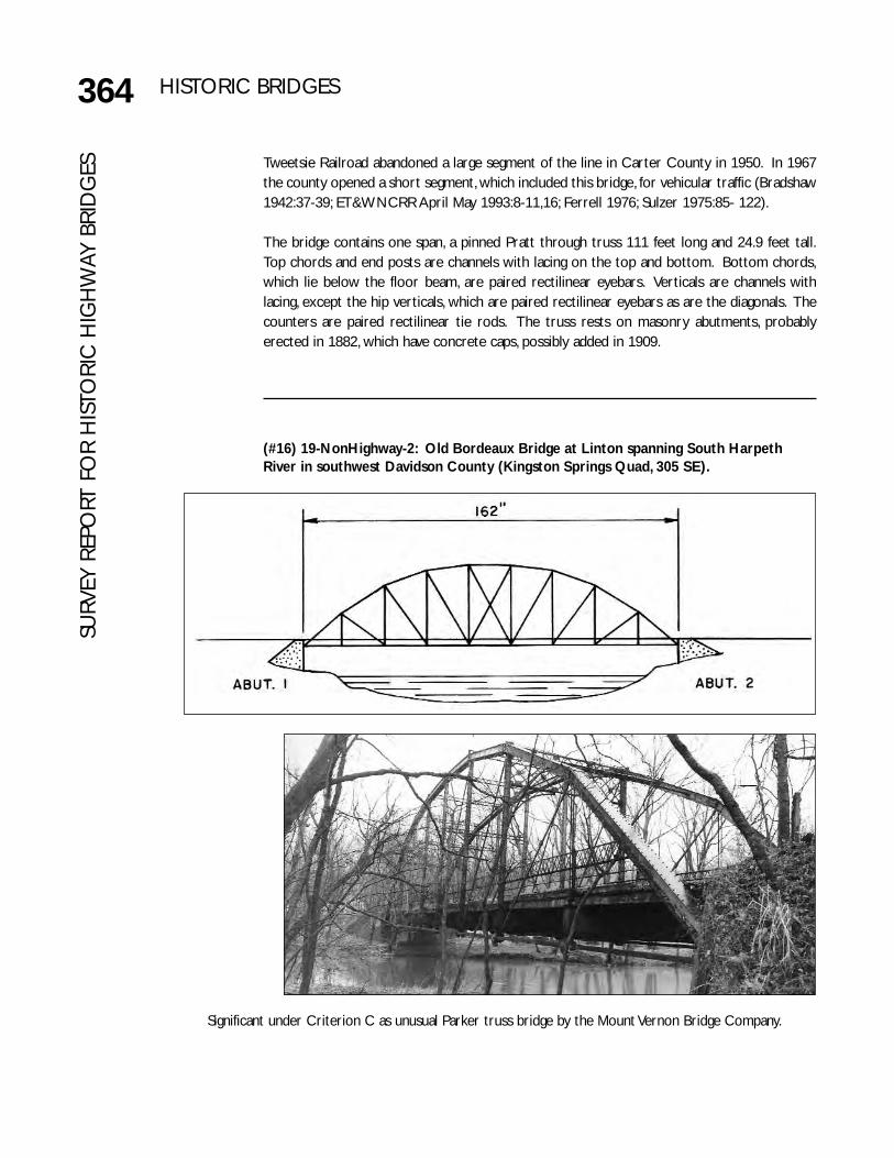
(#16) 19-NonHighway-2: Old Bordeaux Bridge at Linton spanning South HarpethRiver in southwest Davidson County (Kingston Springs Quad, 305 SE).
Significant under Criterion C as unusual Parker truss bridge by the Mount Vernon Bridge Company.

365HISTORIC BRIDGESSU
RVEY REPORT FO
R HISTO
RIC H
IGH
WAY BRID
GES
This span was one of four trusses on the Old Hyde’s Ferry or Bordeaux Bridge that DavidsonCounty built in 1889 over the Cumberland River northwest of Nashville. Designed by Nashvilleengineer E. F. Falconnet, the county awarded the contract for the iron superstructure to theMount Vernon Bridge Company. The bridge was apparently under-built as the need for a largerbridge soon arose. By 1910 engineer Howard Jones, whom the county had hired to examine thebridge, recommended a new bridge, but it was not until 1915 that the county began in earnestto replace the bridge. In 1917 the county hired the Nashville Bridge Company to relocate twoof the trusses from the Hyde’s Ferry Bridge to different sites at Linton for $8,000 and forownership of the two remaining spans (Davidson County Quarterly Court Minutes VolumeA:220-222, 299-301, 323-330, 337-338, 343, 352, 354, 371-372, 444-447, 499, 537-540; VolumeB:11-12, 70, 71, 78-92, 432, 468, 491; Volume H:211-213, 283-291; Volume K:358-359, 402-404, 461,596-597; Volume L:355-357; Graves 1975:105-112; Nashville Bridge Company #3825). Of the twospans erected at Linton, only this one remains. One of the other spans is now part of #112, 89-04261-11.60; it is unknown what happened to the fourth span.
When Nashville Bridge relocated the span to Linton, it removed one panel and reduced theoriginal length of 180 feet to 162 feet. It also reduced the original width of 20 feet to 16 feet.The top chords and end posts are channels with lacing as are the verticals. The diagonals and thebottom chords are paired rectilinear eyebars. The hip verticals are paired rectilinear eyerods.The counters are single rectilinear tie rods. The substructure is concrete. The bottom chordsare below the floor beams, which is somewhat unusual. The elaborate two tier lattice railingremains. The lattice portal bracing and arched knee bracing contains a boss diamond decorativedetail. This gracefully curved variation of the Parker is sometimes called an “elliptical truss” or“curved chord truss.”
This bridge is located on a bypassed segment of a bypassed road, and although closed to traffic,it remains intact.

366 HISTORIC BRIDGESSU
RVEY
REP
ORT
FO
R H
ISTO
RIC
HIG
HW
AY B
RID
GES (#17) 52-A0487-04.85: Stone Bluff Bridge spanning Elk River southwest of
Fayetteville in Lincoln County (Dellrose Quad 66 SE).
Significant under Criterion C as rare Double Intersection Pratt by the King Iron BridgeCompany.
In January 1889 the Lincoln County Court approved up to $8,000 to build a bridge at this siteand appointed a committee of S. A. Hill, D. H. Patterson, and D. C. Sherrill. However, the exactlocation of the bridge proved to be controversial as local citizens lobbied to get a new bridgeinstead at the mouth of Coldwater Creek (where the county would build #23, 52-A0494-

367HISTORIC BRIDGESSU
RVEY REPORT FO
R HISTO
RIC H
IGH
WAY BRID
GES
00.22 in 1891). In February the county let a contract to the King Iron Bridge Company tobuild this bridge, but in April the court rescinded its order. However, the next day the courtreversed itself and again approved the bridge. By October, King Iron had finished its work, andthe county paid it $7,726.14. In January 1890, the committee reported that all work had beendone and all settlements with contractors had been made (Fayetteville Observer 10, 17 January,28 February, 4 April, 2, 23 May, 6 June, 10 October 1889, 9 January 1890; Lincoln County CourtMinutes Book 1888-1890:160-161, 219, 226-228, 340, 420-423).
The Stone Bluff Bridge contains an iron 192 foot pin connected Double Intersection Pratttruss and a 53-foot pin connected Pratt half-hip pony truss. Sitting on a masonry substructure,the bridge’s minimum vertical clearance is 15.0 feet. It has a curb-to-curb width of 13.0 feetand an out-to-out width of 16.0 feet. The composition of the main span is typical. Top chordsand end posts are channels with battens. Bottom chords are paired rectilinear eyebars.Verticals are small channels with lacing, except the hip verticals, which are paired rectilineareyerods. Diagonals are paired rectilinear eyebars, and the counters are single or paired tierods. One unusual feature of the bridge is the “V” shaped floor beams. The portal treatmentcontains a three-circle decorative motif that is common for many of King Iron’s bridges. Thepony truss is possibly a replacement for an earlier span and its composition is also typical. Topchords and end posts are channels with lacing on the top and bottom. Diagonals and countersare paired cylindrical tie rods. Verticals are paired angles with lacing. Bottom chords arepaired rectilinear eyebars.
Due to its condition, the county closed this bridge to traffic in May 1981. During constructionfor a new bridge in October 1982, the bridge was accidentally destroyed.

368 HISTORIC BRIDGESSU
RVEY
REP
ORT
FO
R H
ISTO
RIC
HIG
HW
AY B
RID
GES (#18) 52-SR274-06.82: Coldwater Bridge spanning Coldwater Creek southwest
of Fayetteville in Lincoln County (Taft Quad, 73 SW).
Significant under Criterion A for its role in development of transportation in the county andunder Criterion C as an unusual Warren pony truss bridge.
In 1887 the Decatur, Chesapeake, and New Orleans Railway Company was incorporated toconstruct a 135 mile line between Decatur, Alabama, and Gallatin, Tennessee. Believing that arailroad would aid the county’s growth, Lincoln County promised the railroad a subsidy of$150,000 if the railroad built the line through the county. However, after Lincoln County

369HISTORIC BRIDGESSU
RVEY REPORT FO
R HISTO
RIC H
IGH
WAY BRID
GES
refused to pay the subsidy, the railroad went bankrupt and the only portion of the linecompleted was a thirty-six mile section built in 1889, of which twenty miles was in LincolnCounty. Rockwell, Anderson and Company of Chattanooga built the superstructure of thebridges on the railroad. Alliger and Golightly of Florence, Alabama, built the masonrysubstructures. Over the following years, the line served local needs, and many smallcommunities flourished around the railroad stops including Coldwater. By the 1920spassenger service declined, due in part to the growth of highway travel, and in 1929 therailroad ceased operation. During that summer Lincoln County purchased the old roadbed(with bridges) and converted it into a county road. Since then, Coldwater, as well as manyother small communities, have disappeared and most of the railroad related buildings andstructures have been replaced (Bailey 1969:252-268; Carver 1985b; Fayetteville ObserverFebruary 1889 through November 1889; Lincoln County News Supplement 1904; Sulzer1975:53-66).
Erected in 1889, this bridge contains two spans, each a pin-connected Warren pony truss 50feet long and 8.0 feet in height. The bridge has a curb-to-curb width of 13.3 feet and an out-to-out width of 21.0 feet. The composition of this bridge is much different from that of bridgesoriginally built for highway use. However, since this survey did not generally inventory railroadbridges, it is difficult to conclude if the composition of members is significant even if it isunusual for highway bridges. Top chords and end posts are two large side-by-side channelswith a smaller channel riveted and welded inside. Bottom chords extend across two panels.These members are paired rectilinear eyebars that connect on the exterior side of the endposts. Between these eyebars is an I-beam whose end encircles the pinned connection. Belowthese members is one cylindrical rod; this threaded tension rod passes completely through theweb of the end post where a hex nut secures it. The verticals are large paired rectilineareyebars. At each vertical a lateral bracing member of paired angles riveted together extendsdiagonally outward. The diagonals appear to be two large eyebars with a channel riveted andwelded between them.
The Tennessee Department of Transportation, in cooperation with and the Federal HighwayAdministration demolished this bridge and erected a new bridge at this site in 1986.

370 HISTORIC BRIDGESSU
RVEY
REP
ORT
FO
R H
ISTO
RIC
HIG
HW
AY B
RID
GES (#19) 73-A0330-00.84: Bridge spanning Paint Rock Creek south of Paint Rock in
southeast Roane County (Pattie Gap Quad, 124 NE).
Significant under Criterion C as early iron Bedstead truss bridge by the Champion Bridge Company.
At the April 1889 meeting of the Roane County Court, the members of the court agreed to replacea wooden bridge at this site with an iron bridge. Subsequently the county awarded a contract for$1,200 to the Champion Bridge Company. The Champion Bridge Company completed the bridgeand the county accepted it sometime prior to October (Roane County Court Minutes VolumeB:229-230, 237, 343).
This bridge contains a 39-foot pin-connected Pratt Bedstead pony truss and three 15 foot steel I-beam approaches. Five feet in height, the truss has a curb-to-curb width of 11.7 feet and an out-to-out width of 13.8 feet. The abutments are concrete and the truss legs sit on concrete pads.Composition of members is typical. Top chords are channels with battens. End posts, formed ofchannels with battens, are 12.5 feet tall, and crossed cable bracing connects each set. Verticals arepaired angles with lacing. Diagonals in the center panels are single rectilinear tie rods with pairedrectilinear eyebars in the flanking panels. Paired rectilinear eyebars form the bottom chords in thecenter panel, but in each flanking panel, single I beams extending at an angle from the hip verticalsto a point on the end posts about two feet below the road level form the bottom chords.
The county replaced this bridge with a new structure in 1987.

371HISTORIC BRIDGESSU
RVEY REPORT FO
R HISTO
RIC H
IGH
WAY BRID
GES
(#20) 33-03544-00.12: Walnut Street Bridge spanning the Tennessee River indowntown Chattanooga in Hamilton County (Chattanooga Quad, 105 SE).
Significant under Criterion A for role in community development and under Criterion C asoutstanding truss bridge and as work by Thacher.
Prior to this bridge, there had been a river bridge at Chattanooga only briefly from 1864 to1867, and afterwards ferries provided the only crossings. By the early 1880s local citizensbegan requesting a bridge and a series of committees worked on the project. Although theypersuaded the state legislature to authorize legislation in 1885 for a bond issue, the countycourt refused to appropriate the money. In disgust, a group of local citizens on 13 August 1887

372 HISTORIC BRIDGESSU
RVEY
REP
ORT
FO
R H
ISTO
RIC
HIG
HW
AY B
RID
GES incorporated as the Chattanooga Bridge Company to form a stock company to build a toll
bridge. They immediately contracted with Edwin Thacher’s Decatur Bridge Company to designand build a bridge. However, Decatur failed to build the bridge. Finally, the stock companygave its assets to the county in return for its agreement to build a free bridge. The county’sbridge committee included A. J. Gahagan, R. M. Barton, F. B. Thompson, B. R. Thomas, W. H.Converse [later of the Converse Bridge Company], and F. de Travernier. Barton, credited withobtaining the county’s commitment to build a bridge, soon resigned and John Messick replacedhim.
By the late 1880s, Decatur Bridge had gone into receivership and Thacher had established aconsulting engineer’s office in Louisville. The county hired nationally recognized Thacher(1839-1920) as chief engineer. He had worked briefly as an engineer with the Cedar Rapidsand Missouri River Railroad in 1863, for the U.S. Military in 1864-1865, and for the Louisville,Cincinnati, and Lexington Railroad in 1866-1868. From 1868-1879 he worked for theLouisville Bridge and Iron Company. From 1879 to 1887, he worked for the Keystone BridgeCompany that appointed him as chief engineer in 1883. Thacher was chief engineer and vice-president of the Decatur Bridge Company from 1887-1889 until it went into receivership.Afterwards, Thacher opened an office in Louisville as a consulting engineer. During the 1880sand 1890s, he became more interested in concrete bridges and became a national leader inconcrete arches during the infancy of that bridge type. Thacher built the world’s largestconcrete arch of its kind in Topeka between 1894 and 1899. From 1901, until his retirementin 1912, Thacher and William Mueser were partners in the firm Concrete Steel EngineeringCompany of New York City. In the 1880s Thacher patented the Thacher Truss and in the1890s, patented improvements for concrete arch bridges such as the “Thacher Bar.” He wasalso well known as a mathematician patenting the Thacher Cylindrical Slide Rule in 1881 anda flat slide rule in 1900. In addition to this bridge, the survey identified one other bridge thatThacher designed in Tennessee, the Clinch Avenue Viaduct in Knoxville; (#48, 47-A0135-00.42).
The resident engineer was J. A. Fairleigh and the assistant engineer was E. E. Betts. The countychose the Smith Bridge Company to build the superstructure from about twenty applications.The county let the contract to the Neely Smith Company of Chattanooga to build thesubstructure. Smith Bridge subcontracted the superstructure to McCauley and Morse ofPittsburgh and that firm's foreman, L. L. Gross, directed construction.
For a bridge of this size, work proceeded relatively smoothly. Even so, accidents killed threelaborers; a beam hit one and two drowned.
One point of continued discussion was the streetcar line. Several companies vied for the rightto cross the bridge, and after that decision was made, the companies continued to wrangleabout their fees. The county at first insisted on the streetcars being powered by mules orhorses because it did not want the bridge used for the then experimental electrical poweredlines. The telephone company wanted to extend lines across the bridge, but the countyinsisted on a fee that the company did not want to pay. County residents in Hill Citysupported the telephone company’s feeling that their taxes were paying for a bridge thatwould benefit the city more than it would them. Actually, the bridge resulted in a real estateboom in the Hill City area that greatly expanded Chattanooga’s size.
Although the contractor largely completed the bridge by November 1890, a lost shipment oflumber delayed completion of the bridge. About 5,000 people attended elaborate dedication

373HISTORIC BRIDGESSU
RVEY REPORT FO
R HISTO
RIC H
IGH
WAY BRID
GES
ceremonies held on 18 February 1891. The bridge cost about $247,000 that included $96,198for the substructure; $130,189 for the superstructure; $7,828 for streetcar lines; $3,981 forinspection; and $8,194 for engineering and incidentals. Ironically, after years of unwillingnessby the county to build the bridge, a May 1891 Engineering News article stated that a privatefirm that wanted to operate it as a toll bridge had offered the county a sum in excess of thebridge’s cost.
By 1897 electricity powered the streetcars, and a fire that destroyed two of the approachspans was attributed to a spark from the lines. Over the following years numerous firesoccurred, usually caused by lighted cigarettes tossed on the sidewalks. Several suicidesoccurred from the bridge, and it was the site of at least two lynchings. Substantial repairs weremade to the bridge in 1914, 1938, 1948, 1955, 1957, 1960, 1974 and 1977. The city barricadedthe bridge to traffic on 11 May 1978 and it remained closed until the City of Chattanoogarenovated it for pedestrian use and reopened it in 1993 (Gaston 1979; 1987; Hulan 1989;Jackson 1988:185-186).
The Walnut Street Bridge is 2,370 feet long and contains six pin connected through modifiedCamelback trusses and thirty nine steel stringer spans. Beginning on the south (or downtownChattanooga) end, the bridge contains two 210-foot trusses that are 38.0 feet tall at theirhighest points, three 320-foot channel spans that are 48 feet tall at their highest points, andone 210 foot span. The curb-to-curb width is 18.6 feet and sidewalks expand the out-to-outwidth to 30.0 feet. The minimum vertical clearance is 19.3 feet at the portal and 20.6 feet atthe sway bracing. Each panel is 20 feet in length. The composition of truss members is typicalalthough due to various repairs there are variations. Top chords and end posts are channelswith lacing underneath. Bottom chords are rectilinear eyebars. Verticals are I-beams or angleswith lacing. The diagonals and counters are paired rectilinear eyebars. Generally, compressionmembers are iron, and tension members are steel.
The bridge has an elaborate railing of overlapping arches above latticing. The portal bracingconsists of a single cross with a flower motif in the center. The arched knee bracing containsa wagon-wheel motif. An elaborate iron plaque that contained the overlapping arch motiffound in the rail and the wagon wheel motif was removed in 1960 but restored as part of the1990s renovation.
The substructure for the truss portion of the bridge consists of one small abutment and sixpiers all of grouted limestone masonry resting on bedrock and with concrete caps. All of thesepiers, except for pier six (which is on land), have nosings or shoulders on both the upstreamand downstream sides. The piers are generally 50 feet wide and 20 feet deep at their base andrange in height from 60 to 108 feet. A 780-foot viaduct, lying on a 3.6 percent grade andcomposed of thirty-nine steel stringers on bents made of channels connected with lacing,forms the north end of the bridge.

374 HISTORIC BRIDGESSU
RVEY
REP
ORT
FO
R H
ISTO
RIC
HIG
HW
AY B
RID
GES (#21) 63-A0456-01.88: Sulphur Fork Bridge at Port Royal spanning Sulphur Fork
Creek in northeast Montgomery County on the Robertson County line (SangoQuad, 303 SW).
Significant under Criterion C as an early Pratt truss by the Converse Bridge Company.

375HISTORIC BRIDGESSU
RVEY REPORT FO
R HISTO
RIC H
IGH
WAY BRID
GES
Earlier bridges were erected at this site in 1842 and 1859, and it was a relatively major crossingin the nineteenth century. Between 1885 and 1890, Robertson and Montgomery Countiesrepeatedly tried to reach an agreement on building a bridge here. The source of contention,as might be expected, was money: Montgomery County wanted each to pay half, andRobertson County wanted each to pay based on the number of voters in each county (whichwould be cheaper for it). The counties finally agreed to Robertson’s plan with MontgomeryCounty paying $1,340 and Robertson County paying $960. In January 1890, the counties leta contract to Converse Bridge for the new structure, but in April all the falsework washedaway and work began anew. Converse completed the bridge by July 1890 (Brehm 1982;Carver 1988; Montgomery County Court Minutes Volume 31:349, 394; Volume 32:145, 356,402, 483, 535, 583; Volume 33:17; Winters 1968).
The Sulphur Fork Bridge contains one main span, a pin connected Pratt through truss 114 feetlong resting on masonry piers. Two reinforced concrete deck girder spans on cast-in-placeconcrete piers and abutments, which the county built about 1955 to replace the originalapproaches, flank the truss. The overall length is 231 feet and the vertical clearance is 13.1feet. The curb-to-curb width is 11.8 feet, and the out-to-out width is 14.5 feet. The truss is18.9 feet tall. The portal bracing contains a latticed design.
The overall composition of the bridge is typical of truss bridges of this period, but somespecific details are unusual. The top chords and end posts are channels with lacing underneath.The bottom chords are paired rectilinear eyebars. The verticals are channels with lacingexcept the hip verticals, which are single eyerods that split at the bottom into four one-inch“fingers” looping the pin. The diagonals are double rectilinear eyebars except those in thecenter panel which are paired cylindrical tie rods as are the counters. The bottomconnections of the hip verticals are not typical for most 1890s bridges in Tennessee but similarconnections were used on the Riggins Mill Bridge (63-A0448-00.82; collapsed c. 1984) whichappears to have been built by the Wrought Iron Bridge Company in the late 1880s. SinceConverse was an agent for Wrought Iron for a few years, he may have decided to use thisatypical feature in the 1890s even though by then major companies had ceased using it.
The Tennessee Department of Transportation, in cooperation with Montgomery andRobertson Counties and the Federal Highway Administration, built a new bridge nearby in1990 and closed this bridge to vehicular traffic. It is now a pedestrian bridge within the PortRoyal State Park.

376 HISTORIC BRIDGESSU
RVEY
REP
ORT
FO
R H
ISTO
RIC
HIG
HW
AY B
RID
GES (#22) 11-NonHighway-1: Sycamore Mills Bridge spanning Sycamore Creek
northeast of Ashland City in Cheatham County (Ashland City Quad, 304 SE).
Significant under Criterion C as rare fixed, cable stayed suspension bridge and as work of E. C. Lewis.
E. C. Lewis designed and built the Sycamore Mills Bridge, erected in 1891 (Cheatham CountyCourt Minutes Volume F:240, 319). It was located on a north-south county road that laterbecame State Route 49. The state bypassed this bridge with a truss bridge downstream about1930, but this bridge remained in local use until about 1940 and was then used on a farm road.It is located within the National Register Sycamore Mills Site, a mill village complex inoperation from 1790 to 1904 (Binkley 1980; Fielder and Rogers 1979).

377HISTORIC BRIDGESSU
RVEY REPORT FO
R HISTO
RIC H
IGH
WAY BRID
GES
Trained as a civil engineer, Eugene Lewis (nicknamed “Major” in school) surveyed new railroadlines in the South after his graduation in 1865 from the Pennsylvania Military Academy. In theearly 1870s as part of his job, Lewis bought explosives from the DuPont Powder Company.The association resulted in the DuPonts appointing Lewis as an agent to sell powder at theirSycamore Mills Powder Plant in Tennessee. When the chief stockholder at Sycamore died in1876, the DuPonts bought his shares and appointed Lewis general manager. In a few years,Lewis became president of the mills. During his association with the mills, Cheatham Countyhired Lewis in 1891 to design and build the Sycamore Mills Bridge across Sycamore Creek thatran through the mill complex.
Throughout his life Lewis actively participated in the railroad industry. He was on the Boardof Directors for both the Louisville & Nashville Railroad and the Nashville, Chattanooga, & St.Louis Railroad; he later served as board chairman of the latter. This led to his involvementwith the 1897 Tennessee Centennial Exposition over which he was appointed director-general.Lewis viewed the Exposition as a means to increase railroad travel to Nashville. Thus, duringthe late 1890s, Lewis moved to Nashville where he designed his own home that included suchunusual features as rounded corners and a bed suspended from the ceiling. In 1896 he boughtand became publisher of a local newspaper that he used in large part to promote theExposition.
Lewis is probably best remembered for his work with the Exposition. As director-general, hewas responsible for the construction of all the fair's buildings. Lewis pushed for a “class” eventand persuaded those involved to provide landscaping with reflecting pools and flowers. Hewanted to recreate a replica of the Greek Parthenon, now one of Nashville's best knownlandmarks. He designed the Shell Spring, the bandstand, and a monument to James Robertson.As the Exposition neared its end, Lewis successfully pushed to retain the Parthenon and theExposition grounds as a permanent park to be known as Centennial Park.
Lewis participated in several Nashville construction projects as a builder. These included thedowntown Castner-Knott building and the transfer station for the Nashville railway system.He also superintended the construction in 1906 of the railroads’ Union Station. Sometimeprior to 1904, the DuPonts asked Lewis to recommend a site for a powder mill near Nashville.Because of anti-trust laws that resulted in the break-up of Dupont in 1904, the plant was notbuilt until World War I increased the demand for explosives. The world’s largest powder, dye,and acid plant was built at the site on Hadley’s Bend that Lewis had originally recommended.
When Lewis died in 1917, during his funeral all traffic stopped for five minutes on the railroadswith which he had been associated. He is buried at Mount Olivet Cemetery in Nashville in afamily vault that he had designed in the shape of a pyramid guarded by a pair of exteriorsphinx.
The survey identified only one bridge designed by Lewis, the Sycamore Mills Bridge, a cablestayed suspension bridge. It is approximately 140 feet long and 12 feet wide. It contains threespans supported by two identical towers. The towers are about 30 feet in height and arecomposed of four channels that join at the top but form an A shape as they extend to thewater. Lateral bracing connects them at four points. Each of the two towers has a “twintower” or double plane configuration, that is, a tower extends vertically on each side of theroadway. While such towers may stand independently of each other, in this case, lateral bracingconnects them at the top and below the deck. This bracing is graceful and gives the bridge a

378 HISTORIC BRIDGESSU
RVEY
REP
ORT
FO
R H
ISTO
RIC
HIG
HW
AY B
RID
GES unique aesthetic appearance. On the top a single I bar connects the towers and below it is a
single arched member. The spandrel area formed by these two members contains circularplates. Each plate contains the date 1891 and the names of the bridge committee and thephrase “E. C. Lewis Engineer and Contractor.” Two arched members are located below thedeck. The cables do not loop over the towers as is common with traditional suspensionbridges but instead connect at the top. From the top of the tower, a single eyerod extendsdiagonally toward the deck. At about midpoint it joins (with a pinned connection) two eyebarsthat extend to the deck where they have pinned connections. With its floor beams and lateralbracing system, the deck is very similar to truss bridges.
In 1978 the Historic American Engineering Record identified this bridge as possibly the onlynineteenth century, fixed cable stayed bridge in the United States (Griffin 1978).
The old roadbed with this bridge is located within a farm, and although deteriorated, remainsintact.
(#23) 52-A0494-00.22: Hobbs Bridge spanning the Elk River southwest ofFayetteville near Coldwater in Lincoln County (Taft Quad, 73 SW).
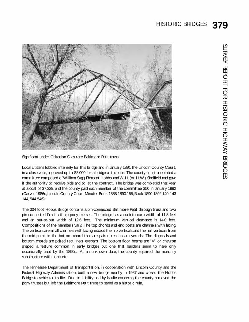
379HISTORIC BRIDGESSU
RVEY REPORT FO
R HISTO
RIC H
IGH
WAY BRID
GES
Significant under Criterion C as rare Baltimore Petit truss.
Local citizens lobbied intensely for this bridge and in January 1891 the Lincoln County Court,in a close vote, approved up to $8,000 for a bridge at this site. The county court appointed acommittee composed of William Sugg, Pleasant Hobbs, and W. H. (or H. W.) Sheffield and gaveit the authority to receive bids and to let the contract. The bridge was completed that yearat a cost of $7,329, and the county paid each member of the committee $50 in January 1892(Carver 1986c; Lincoln County Court Minutes Book 1888 1890:155; Book 1890 1892:140, 143144, 544 546).
The 304 foot Hobbs Bridge contains a pin-connected Baltimore Petit through truss and twopin-connected Pratt half-hip pony trusses. The bridge has a curb-to-curb width of 11.8 feetand an out-to-out width of 12.6 feet. The minimum vertical clearance is 14.0 feet.Compositions of the members vary. The top chords and end posts are channels with lacing.The verticals are small channels with lacing, except the hip verticals and the half verticals fromthe mid-point to the bottom chord that are paired rectilinear eyerods. The diagonals andbottom chords are paired rectilinear eyebars. The bottom floor beams are “V” or chevronshaped, a feature common in early bridges but one that builders seem to have onlyoccasionally used by the 1890s. At an unknown date, the county repaired the masonrysubstructure with concrete.
The Tennessee Department of Transportation, in cooperation with Lincoln County and theFederal Highway Administration, built a new bridge nearby in 1987 and closed the HobbsBridge to vehicular traffic. Due to liability and hydraulic concerns, the county removed thepony trusses but left the Baltimore Petit truss to stand as a historic ruin.

380 HISTORIC BRIDGESSU
RVEY
REP
ORT
FO
R H
ISTO
RIC
HIG
HW
AY B
RID
GES (#24) 58-A0502-00.36: Tate Cove Road spanning Battle Creek in southwest
Marion County (South Pittsburg Quad, 100 SW).
Significant under Criterion C as representative Pratt truss by the King Iron Bridge Company.
In January 1891, the Marion County Court appointed a bridge committee of J. S. Raulston, M.V. Wynick, H. R. Deakins, and J. G. Lancaster to locate a potential site for a bridge across BattleCreek at Ketch-All and to ascertain the cost. In April, this committee reported that it hadreceived bids for the bridge from the following companies: Columbus Bridge, $4,049; CantonBridge, $3,963; Pittsburg Bridge $4,050; Smith Bridge of Toledo $4,129; and King Iron $3,789.The county awarded the contract to the lowest bidder, King Iron. The contract specified thatthe bridge, an iron truss 110 by 12 feet with 30-foot wooden approaches on each end, was tobe completed by 10 August 1891. The truss span was relocated to this site about 1930,probably in conjunction with local road improvements by the state (Marion County CourtMinutes Volume A:125-126).

381HISTORIC BRIDGESSU
RVEY REPORT FO
R HISTO
RIC H
IGH
WAY BRID
GES
(#25) 77-NonHighway-1: Hatfield Bridge spanning the Sequatchie River south ofDunlap in Sequatchie County (Daus Quad, 104 SW).
The bridge contains one 110-foot pin-connected Pratt through truss and two steel I-beamspans. The bridge originally contained an elaborate portal treatment of laced horizontalbracing and arched knee bracing with a three-circle motif, but the county replaced thesemembers with angles in the 1990s. The bridge has a curb-to-curb width of 12 feet and an out-to-out width of 13 feet. Steel encased concrete tubular piers and masonry abutments formthe substructure. Composition of the members is typical. Top chords and end posts arechannels with battens. Bottom chords and diagonals are paired rectilinear eyebars. Verticalsare laced beams, except the hip verticals, which are paired rectilinear eyebars. The countersare single cylindrical tie rods. One unusual feature is the “V” shaped floor beams.
In the 1990s, the county built a new bridge nearby and left the old bridge as a ruin, removingmuch of the decorative features but leaving the core bridge.
Significant under Criterion C as representative Pratt truss by the King Iron Bridge Company.

382 HISTORIC BRIDGESSU
RVEY
REP
ORT
FO
R H
ISTO
RIC
HIG
HW
AY B
RID
GES In May 1892, the Sequatchie County Court appointed a committee to accept bids and contract
for an iron bridge at this site. In July 1892, the court appointed another committee to repairthe bridge and in July the court paid $33 for those repairs. The court appointed anothercommittee in July to investigate the cost of a timber bridge at this site and report its findingsto the court at its October session. At the October session, the court ordered the bridge tobe declared unsafe, for the sheriff to barricade it, and to notify the public of these actionsthrough the local newspaper (Sequatchie County Court Minutes Volume D:162, 202, 203, 239).It is assumed that the county built this bridge soon afterwards, circa 1893. A plaque identifiesthe builder as the King Iron Bridge Company. The bridge was located on the main north southroute in the area, and in the 1920s the state designated the highway as State Route 28 andU.S. 127. It was also the route of the Taft Memorial Highway, also designated the Alvin C. YorkHighway in Tennessee. The state built a new bridge nearby in 1950 and abandoned this bridge.Although the deck no longer remains, the truss remains intact.
The bridge contains a seven panel pin-connected Pratt through truss about 140 feet long withthree steel I-beam approach spans. The portal contains horizontal bracing formed of twoseparate latticed sections connected by cross bracing. It is one lane wide. Steel encasedconcrete tubular piers and concrete abutments form the substructure. Composition of themembers is typical. Top chords and end posts are channels with battens. Bottom chords arepaired rectilinear eyebars. The verticals are channels with lacing, except the hip verticals,which are paired rectilinear eyebars. A lattice railing runs the length of the bridge.
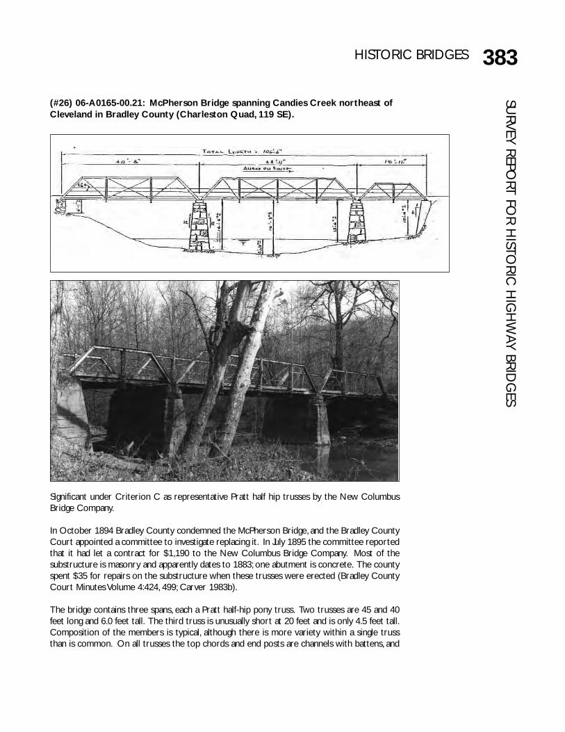
383HISTORIC BRIDGESSU
RVEY REPORT FO
R HISTO
RIC H
IGH
WAY BRID
GES
Significant under Criterion C as representative Pratt half hip trusses by the New ColumbusBridge Company.
In October 1894 Bradley County condemned the McPherson Bridge, and the Bradley CountyCourt appointed a committee to investigate replacing it. In July 1895 the committee reportedthat it had let a contract for $1,190 to the New Columbus Bridge Company. Most of thesubstructure is masonry and apparently dates to 1883; one abutment is concrete. The countyspent $35 for repairs on the substructure when these trusses were erected (Bradley CountyCourt Minutes Volume 4:424, 499; Carver 1983b).
The bridge contains three spans, each a Pratt half-hip pony truss. Two trusses are 45 and 40feet long and 6.0 feet tall. The third truss is unusually short at 20 feet and is only 4.5 feet tall.Composition of the members is typical, although there is more variety within a single trussthan is common. On all trusses the top chords and end posts are channels with battens, and
(#26) 06-A0165-00.21: McPherson Bridge spanning Candies Creek northeast ofCleveland in Bradley County (Charleston Quad, 119 SE).
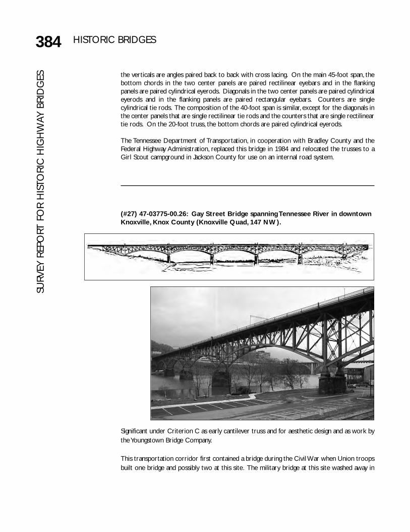
384 HISTORIC BRIDGESSU
RVEY
REP
ORT
FO
R H
ISTO
RIC
HIG
HW
AY B
RID
GES
(#27) 47-03775-00.26: Gay Street Bridge spanning Tennessee River in downtownKnoxville, Knox County (Knoxville Quad, 147 NW).
the verticals are angles paired back to back with cross lacing. On the main 45-foot span, thebottom chords in the two center panels are paired rectilinear eyebars and in the flankingpanels are paired cylindrical eyerods. Diagonals in the two center panels are paired cylindricaleyerods and in the flanking panels are paired rectangular eyebars. Counters are singlecylindrical tie rods. The composition of the 40-foot span is similar, except for the diagonals inthe center panels that are single rectilinear tie rods and the counters that are single rectilineartie rods. On the 20-foot truss, the bottom chords are paired cylindrical eyerods.
The Tennessee Department of Transportation, in cooperation with Bradley County and theFederal Highway Administration, replaced this bridge in 1984 and relocated the trusses to aGirl Scout campground in Jackson County for use on an internal road system.
Significant under Criterion C as early cantilever truss and for aesthetic design and as work bythe Youngstown Bridge Company.
This transportation corridor first contained a bridge during the Civil War when Union troopsbuilt one bridge and possibly two at this site. The military bridge at this site washed away in

385HISTORIC BRIDGESSU
RVEY REPORT FO
R HISTO
RIC H
IGH
WAY BRID
GES
March 1867. Knox County built a covered bridge here in 1874 that blew down 1 May 1875.In 1879, Knox County leased the piers and right-of-way to G. W. Saulpaw who built a woodenHowe truss bridge that opened 2 March 1880. This bridge remained in use until the countycompleted the current bridge in 1898. The Gay Street Bridge was the only vehicular riverbridge in downtown Knoxville until the 1930 Henley Street Bridge (#132, 47 SR033 06.72).
By the early 1890s, Knox County had begun trying to replace Saulpaw's bridge. In October1894 the county appointed a committee of G. L. Maloney (Chairman), W. H. Crawford, and G.W. Hines (Secretary). Over the next two years, the committee investigated masonry archbridges but the county considered the initial bids of $1.5 million too high and began toconsider metal truss bridges.
In April 1896, the county hired nationally recognized Edwin Thacher of Detroit as consultingengineer for the new Tennessee River Bridge, as the county called it. The extent of Thacher’sinvolvement is unknown, but the county paid him $750 for his work. In May 1896, the countyaccepted and reviewed bids for a new bridge from the Schultz, Youngstown, Toledo, and GrotonBridge Companies. The county chose Youngstown’s plan and signed a contract in June. Therepresentative for the Youngstown Bridge Company was Charles Fowler. Fowler claimed hedrew the sketch for the Gay Street Bridge on the back of an envelope during his train ride toKnoxville prior to his first meeting with the county. In addition to designing the bridge, Fowlersupervised construction. Other engineers associated with the project were resident engineerW. C. Crozer whom the county paid $1,255.22 and inspector L. C. Carter whom the countypaid $2,062.13.
Completed in July 1898, the bridge cost $233,000. The bridge opened Monday 4 July and thecounty formally accepted it 6 July proclaiming (in the midst of the Spanish-American War) itbe opened as a “highway bridge for the use of all the world except Spain.” After the grandopening, the county closed the bridge the following Friday night while the Girl's Relief Societyheld a festival on the bridge to raise funds for the war hospital. The county closed the oldbridge Saturday and began advertising for bids to remove it.
The original plans called for a fixed span, but to get approval from the War Department, thechannel span had to be erected without falsework, which required a cantilevered span. Thiseventually led to the main controversy involving the bridge, Youngstown’s payment. The countyclaimed that using a cantilevered span required less metal than the original fixed span, andYoungstown claimed that costs involved in changing the plans as well as unforeseen foundationproblems offset those savings. Further, Youngstown’s shops burned during the project, and thecompany had to reproduce some materials. Youngstown claimed that it lost $8,000 on theproject. However, Youngstown and the county reached a compromise and settled out of courtby the time the bridge formally opened (East Tennessee, Clipping File; Knox County CourtMinutes Volume M:591, Volume N:619-623; Knoxville Journal and Tribune 1898; Knoxville News-Sentinel 1940, 1977; Rule 1900:302-303).
The Gay Street Bridge contains five pin-connected steel arched cantilever trusses that are 252feet long and two 126 foot truss approach spans on a granite foundation, for an overall lengthof 1,512 feet. Fowler proposed a four-lane design but the county chose a two-lane design withstreetcar tracks that were removed in 1949-1950. The bridge now carries three traffic laneswithin a curb-to-curb width of 30.1 feet. There are also two 6.0 foot sidewalks. The bridgeoriginally contained elaborate streetlights but these no longer remain. There is an elaborate
386 HISTORIC BRIDGESSU
RVEY
REP
ORT
FO
R H
ISTO
RIC
HIG
HW
AY B
RID
GES rail with lattice design and circular cut-outs. Composition of members is typical. Top and
bottom chords are channels with lacing. Verticals are small channels with lacing. Diagonals aresmall channels with lacing or paired rectilinear eyebars, and counters are paired rectilineareyebars. The anchored abutments are an unusual feature of the bridge. This system anchoreddown the ends of the bridge instead of the typical arrangement in which the ends rest on theabutment of their own weight. Fowler’s design allowed contractors to work toward themiddle of the bridge while relying on the anchored abutments to offset the weight of theequipment.
An 1896 article in Engineering News featured this bridge as an example of a trend toward moreaesthetic bridge designs (Engineering News 7 May 1896:300). Also, the 1911 publication BridgeEngineering, by noted engineer Henry Tyrrell, discussed this movement and cites this bridge asa good example of the trend toward more aesthetic bridge designs (Tyrrell 1911:385-386).Fowler himself considered the aesthetic appearance of great importance. In one of Fowler’sthirty books, the 1929 Ideals of Engineering Architecture, he used a photograph of this bridge onthe frontispiece and cited it as an ideal aesthetical design saying that it “was of extremesimplicity; of five spans perfectly symmetrical and balanced; in entire harmony in all parts andwith the natural beauties of the location; and the theoretical proportions as correct aspossible for five arched openings” (Fowler 1929:fp, 50, 109-111).
With funds through the Highway Bridge Replacement and Rehabilitation Program, TDOT incooperation with the City of Knoxville and the Federal Highway Administration rehabilitatedthe Gay Street Bridge for continued vehicular use between 2001 and 2004.
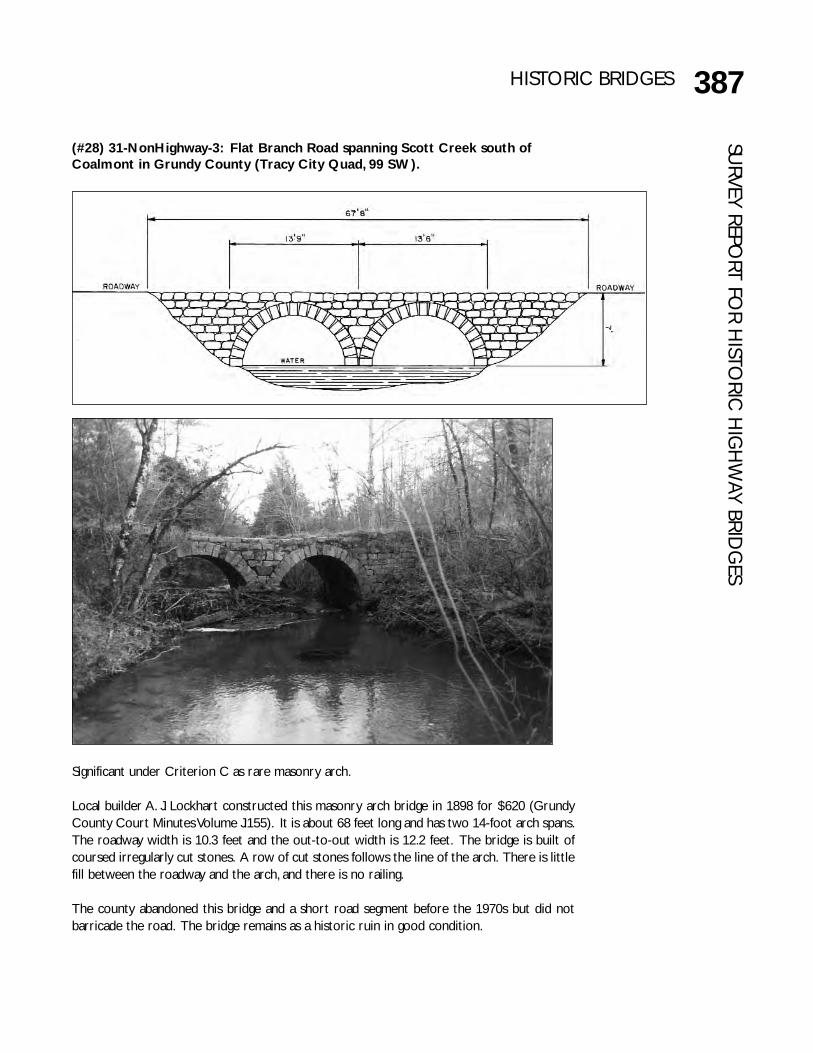
387HISTORIC BRIDGESSU
RVEY REPORT FO
R HISTO
RIC H
IGH
WAY BRID
GES
(#28) 31-NonHighway-3: Flat Branch Road spanning Scott Creek south ofCoalmont in Grundy County (Tracy City Quad, 99 SW).
Significant under Criterion C as rare masonry arch.
Local builder A. J. Lockhart constructed this masonry arch bridge in 1898 for $620 (GrundyCounty Court Minutes Volume J:155). It is about 68 feet long and has two 14-foot arch spans.The roadway width is 10.3 feet and the out-to-out width is 12.2 feet. The bridge is built ofcoursed irregularly cut stones. A row of cut stones follows the line of the arch. There is littlefill between the roadway and the arch, and there is no railing.
The county abandoned this bridge and a short road segment before the 1970s but did notbarricade the road. The bridge remains as a historic ruin in good condition.
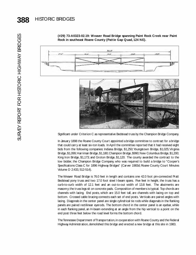
388 HISTORIC BRIDGESSU
RVEY
REP
ORT
FO
R H
ISTO
RIC
HIG
HW
AY B
RID
GES (#29) 73-A0323-02.19: Weaver Road Bridge spanning Paint Rock Creek near Paint
Rock in southeast Roane County (Pattie Gap Quad, 124 NE).
Significant under Criterion C as representative Bedstead truss by the Champion Bridge Company.
In January 1898 the Roane County Court appointed a bridge committee to contract for a bridgethat could carry at least six-ton loads. In April the committee reported that it had received eightbids from the following companies: Indiana Bridge, $1,250; Youngstown Bridge, $1,025; VirginiaBridge, $1,099; Harriman Bridge, $1,180; Champion Bridge, $990; New Columbus Bridge, $1,200;King Iron Bridge, $1,173; and Groton Bridge, $1,120. The county awarded the contract to thelow bidder, the Champion Bridge Company, who was required to build a bridge to “Cooper’sSpecifications Class C for 1896 Highway Bridges” (Carver 1983d; Roane County Court MinutesVolume D 2:433, 512-514).
The Weaver Road Bridge is 76.0 feet in length and contains one 42.0 foot pin-connected PrattBedstead pony truss and two 17.0 foot steel I-beam spans. Five feet in height, the truss has acurb-to-curb width of 12.1 feet and an out-to-out width of 13.8 feet. The abutments aremasonry; the truss legs sit on concrete pads. Composition of members is typical. Top chords arechannels with lacing. End posts, which are 15.0 feet tall, are channels with lacing on top andbottom. Crossed cable bracing connects each set of end posts. Verticals are paired angles withlacing. Diagonals in the center panel are single cylindrical tie rods while diagonals in the flankingpanels are paired rectilinear eyerods. The bottom chord in the center panel is an eyebar, whilein each flanking panel, an H-beam extending at an angle from the hip vertical to a point on theend post three feet below the road level forms the bottom chord.
The Tennessee Department of Transportation, in cooperation with Roane County and the FederalHighway Administration, demolished this bridge and erected a new bridge at this site in 1983.

389HISTORIC BRIDGESSU
RVEY REPORT FO
R HISTO
RIC H
IGH
WAY BRID
GES
(#30) 78-00496-07.09 : Boyd’s Creek Bridge spanning Boyd Creek in northwestSevier County (Boyd’s Creek Quad, 156 NW).
Significant under Criterion C as rare masonry arch.
Greene County Pike Commissioners C. W. Fox, J. W. Sharp, and T. D. McMahan supervised theerection of this bridge in 1898. The engineer was J. C. Thomas. The bridge is located within theNational Register Brabson’s Ferry Plantation Historic District, which was listed in the NationalRegister in 1973 under Criteria A and C for its significance in late eighteenth-century settlementpatterns and nineteenth-century architecture and history (Carberry 1973; Slater 1986).
The 138-foot bridge contains one span, an arch of cut stone laid in a coursed pattern. A row ofcut stones follows the line of the arch. Originally, the bridge probably contained a masonryparapet railing and carried one lane of traffic. At an unknown date, the county widened the deckand added a concrete parapet rail. In the 1970s, the county removed the concrete parapetrailing, widened the bridge deck, and added the existing metal ribbon railing. The bridge nowhas a curb-to-curb width of 28.0 feet and an out-to-out width of 29.4 feet. The bridge retainsits original builder’s plaque that is embedded in a concrete post at the end of the bridge.
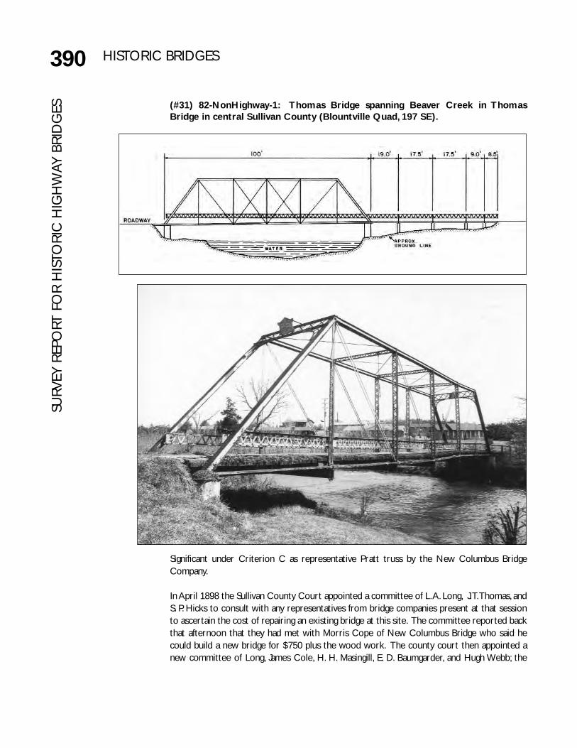
390 HISTORIC BRIDGESSU
RVEY
REP
ORT
FO
R H
ISTO
RIC
HIG
HW
AY B
RID
GES (#31) 82-NonHighway-1: Thomas Bridge spanning Beaver Creek in Thomas
Bridge in central Sullivan County (Blountville Quad, 197 SE).
Significant under Criterion C as representative Pratt truss by the New Columbus BridgeCompany.
In April 1898 the Sullivan County Court appointed a committee of L. A. Long, J. T. Thomas, andS. P. Hicks to consult with any representatives from bridge companies present at that sessionto ascertain the cost of repairing an existing bridge at this site. The committee reported backthat afternoon that they had met with Morris Cope of New Columbus Bridge who said hecould build a new bridge for $750 plus the wood work. The county court then appointed anew committee of Long, James Cole, H. H. Masingill, E. D. Baumgarder, and Hugh Webb; the
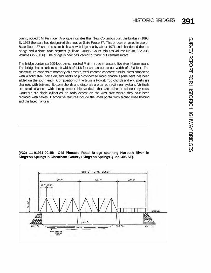
391HISTORIC BRIDGESSU
RVEY REPORT FO
R HISTO
RIC H
IGH
WAY BRID
GES
(#32) 11-01931-00.45: Old Pinnacle Road Bridge spanning Harpeth River inKingston Springs in Cheatham County (Kingston Springs Quad, 305 SE).
county added J. M. Fain later. A plaque indicates that New Columbus built the bridge in 1898.By 1923 the state had designated this road as State Route 37. This bridge remained in use onState Route 37 until the state built a new bridge nearby about 1971 and abandoned the oldbridge and a short road segment (Sullivan County Court Minutes Volume N:318, 322 333;Volume O:72, 136). The bridge is now barricaded to traffic but remains intact.
The bridge contains a 100-foot pin-connected Pratt through truss and five steel I-beam spans.The bridge has a curb-to-curb width of 11.8 feet and an out-to-out width of 13.8 feet. Thesubstructure consists of masonry abutments, steel encased concrete tubular piers connectedwith a solid steel partition, and bents of pin-connected laced channels (one bent has beenadded on the south end). Composition of the truss is typical. Top chords and end posts arechannels with battens. Bottom chords and diagonals are paired rectilinear eyebars. Verticalsare small channels with lacing, except hip verticals that are paired rectilinear eyerods.Counters are single cylindrical tie rods, except on the west side where they have beenreplaced with cables. Decorative features include the laced portal with arched knee bracingand the laced handrail.
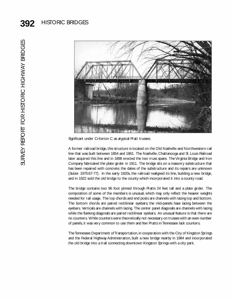
392 HISTORIC BRIDGESSU
RVEY
REP
ORT
FO
R H
ISTO
RIC
HIG
HW
AY B
RID
GES
Significant under Criterion C as atypical Pratt trusses.
A former railroad bridge, this structure is located on the Old Nashville and Northwestern railline that was built between 1854 and 1861. The Nashville, Chattanooga and St. Louis Railroadlater acquired this line and in 1898 erected the two truss spans. The Virginia Bridge and IronCompany fabricated the plate girder in 1911. The bridge sits on a masonry substructure thathas been repaired with concrete; the dates of the substructure and its repairs are unknown(Sulzer 1975:67-77). In the early 1920s, the railroad realigned its line, building a new bridge,and in 1922 sold the old bridge to the county which incorporated it into a county road.
The bridge contains two 96 foot pinned through Pratts 24 feet tall and a plate girder. Thecomposition of some of the members is unusual, which may only reflect the heavier weightsneeded for rail usage. The top chords and end posts are channels with lacing top and bottom.The bottom chords are paired rectilinear eyebars; the mid-panels have lacing between theeyebars. Verticals are channels with lacing. The center panel diagonals are channels with lacingwhile the flanking diagonals are paired rectilinear eyebars. An unusual feature is that there areno counters. While counters were theoretically not necessary on trusses with an even numberof panels, it was very common to use them and few Pratts in Tennessee lack counters.
The Tennessee Department of Transportation, in cooperation with the City of Kingston Springsand the Federal Highway Administration, built a new bridge nearby in 1984 and incorporatedthe old bridge into a trail connecting downtown Kingston Springs with a city park.
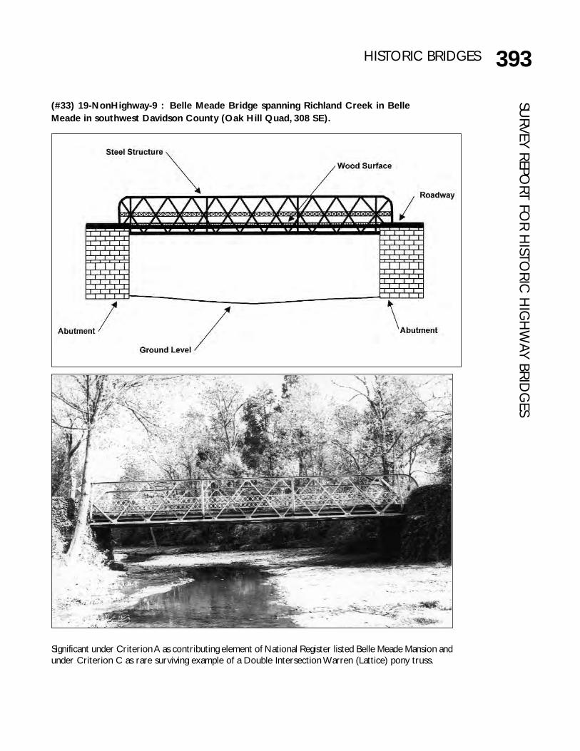
393HISTORIC BRIDGESSU
RVEY REPORT FO
R HISTO
RIC H
IGH
WAY BRID
GES
(#33) 19-NonHighway-9 : Belle Meade Bridge spanning Richland Creek in BelleMeade in southwest Davidson County (Oak Hill Quad, 308 SE).
Significant under Criterion A as contributing element of National Register listed Belle Meade Mansion andunder Criterion C as rare surviving example of a Double Intersection Warren (Lattice) pony truss.

394 HISTORIC BRIDGESSU
RVEY
REP
ORT
FO
R H
ISTO
RIC
HIG
HW
AY B
RID
GES This bridge is located on the main entrance drive to Belle Meade Mansion, a National Register
listed property. John Harding, in 1807, established a plantation at this site that grew to includeseveral thousand acres and that became recognized as one of the finest thoroughbred farmsin the country. The family also sold breeding stock of ponies, cattle, sheep, and goats. Theproperty passed to General William Giles Harding in 1839 who built the present mansion, andthen to his daughter Selene and her husband General William Hicks Jackson and then, to theirson William Harding Jackson. The family entertained lavishly, and numerous notables visitedthe property including Presidents Polk, Harrison, Theodore Roosevelt, Taft, and Cleveland.
At the turn of the century, Belle Meade was believed to be the oldest and largestthoroughbred farm in the United States, but it was also in financial trouble. Between 1902 and1904, the owners sold the property and livestock. Real estate developers purchased much ofthe property and converted it into an exclusive residential subdivision, Belle Meade Park (see#51, 19 B0983-01.61). Other families owned and used the property as a private residenceuntil 1953 when the State of Tennessee purchased it for use as a house museum. It also servesas state headquarters for the Association for the Preservation of Tennessee Antiquities. Extantbuildings include the family’s original log cabin (which may date to 1792 as Dunham’s Station),the brick ante-bellum mansion, carriage house, stable, and dairy (Coop 1969; Ellis 1983; Tidwell1983).
The bridge is located on the main driveway leading to the mansion. The original fabricator anddate of erection are unknown. However, an 1894 photograph (Parish 1894) shows a timberstringer bridge at this location, and pre-1903 photographs of Belle Meade (Belle MeadeMansion:P-68, 70) show this bridge and an identical bridge at the old Natchez Trace crossingon the property (which is now probably bridge #34, 83-NonHighway-4). The constructiondate is estimated to be about 1900. The bridge contains one span, a 53-foot DoubleIntersection Warren (Lattice) pony truss resting on massive masonry abutments that riseabove ground level to form walls flaring outward from the drive. The curb-to-curb width is12 feet and the out-to-out width is 13.5 feet. The truss is 6.5 feet tall. The composition ofthe truss is somewhat different from that of highway bridges. Bottom chords, top chords, andend posts are angles paired back to back. The top chords curve downward, without aconnection, into vertical end posts, forming a single member. Diagonals are single angles. Fouroutriggers, formed of angles paired back to back that curve into the bottom chord, providelateral bracing on the outside of the truss. The railing is composed of angles in a lattice patternwith a diamond shaped boss detail.

395HISTORIC BRIDGESSU
RVEY REPORT FO
R HISTO
RIC H
IGH
WAY BRID
GES
(#34) 83-NonHighway-4: Dry Fork Creek Bridge spanning Dry Creek on CarrDriveway off Dry Fork Creek Road northeast of Gallatin in Sumner County(Gallatin Quad, 313 NW).
Significant under Criterion C as rare surviving example of a Double Intersection Warren (Lattice) ponytruss.

396 HISTORIC BRIDGESSU
RVEY
REP
ORT
FO
R H
ISTO
RIC
HIG
HW
AY B
RID
GES The original location, builder, and owner of this bridge are unknown except that it was built
for use on a private driveway in Belle Meade, an exclusive residential area of Nashville (Carr1994). The original construction date is estimated to be about 1900.
During the early twentieth century, people traveling to the Dry Fork Creek School eitherforded Dry Fork Creek or crossed on a “swinging” (crude suspension) bridge. In the mid-1940s, the teacher dismissed school early due to a storm and the fear that the creek wouldrise and thus strand the children at school. While the teacher was escorting the childrenacross the swinging bridge, a child slipped and fell into the creek and drowned. An unidentifiedBelle Meade resident, who was then replacing his driveway truss bridge with a new concretestructure, read about the incident in a Nashville newspaper and donated the truss bridge tothe school (Carr 1994). Pre-1903 photographs of Belle Meade Mansion (Belle MeadeMansion:P-68, 70) show a bridge at the old Natchez Trace Crossing identical to this bridge,and it is believed probable that the original location of this bridge was at the Belle Meadeproperty (see #33, 19-NonHighway-9). The county and local residents moved and erected thetruss bridge at its present location.
The Dry Fork Creek Bridge contains one span, a 52.5-foot Double Intersection Warren(Lattice) pony truss resting on concrete abutments. The curb-to-curb width is 11.5 feet, andthe out-to-out width is 12.5 feet. The truss is 6.0 feet in height. The composition of the trussis identical to that of the Belle Meade Bridge. Bottom chords, top chords, and end posts areangles paired back to back. The top chords curve downward, without a connection, intovertical end posts, forming a single member. Diagonals are single angles. Four outriggers,formed of angles paired back to back that curve into the bottom chord, provide lateral bracingon the outside of the truss. The railing is composed of angles in a lattice pattern with adiamond shaped boss detail.
The bridge is now located on a farm road off Dry Fork Creek Road.