hiroshi sasakawa ph. d. japan forest technology association remote sensing expert jica project in...
TRANSCRIPT

JICA National Land Cover Datasets in African Countries
Hiroshi Sasakawa Ph. D.
Japan Forest Technology AssociationRemote sensing expert
JICA Project in Gabon
International Symposium on Land Cover Mapping for the African Continent
26th Jun,2013 Nairobi

Contents of Presentation
1. JICA Projects in Africa2. General Scope of Projects3. Objectives for development of LC maps4. Comparison of Projects5. Case study in Gabon6. Conclusion
JICA/JAFTA 2
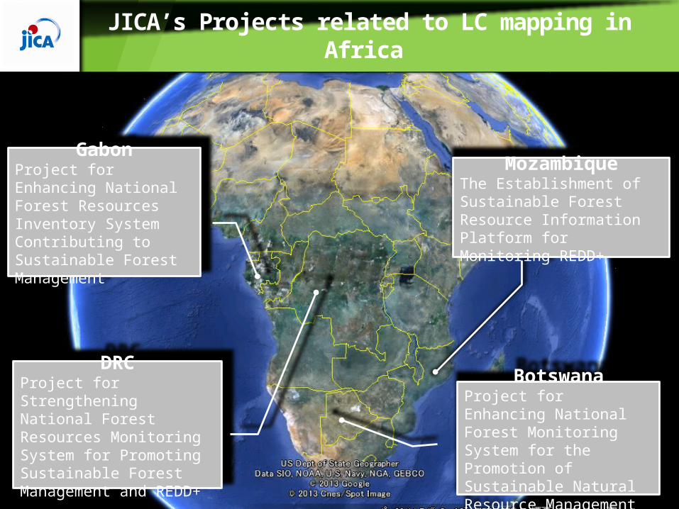
JICA’s Projects related to LC mapping in Africa
©Japan Forest Technology Association 3
GabonProject for Enhancing National Forest Resources Inventory System Contributing to Sustainable Forest Management
DRCProject for Strengthening National Forest Resources Monitoring System for Promoting Sustainable Forest Management and REDD+
MozambiqueThe Establishment of Sustainable Forest Resource Information Platform for Monitoring REDD+
BotswanaProject for Enhancing National Forest Monitoring System for the Promotion of Sustainable Natural Resource Management

JICA/JAFTA 4
Development of Land Cover Map using remote sensing
Designing Field inventory
Development of GIS/ Database
Forest Types Area
Forest Distribution• Design of NFI• Statistical Approach GIS Layer
• GIS Layer• Attribute Information
General Scope of JICA Project
• Development of Forest Resource Inventory System• Basic Information for REDD+ • Contribution for Sustainable Forest Management

Estimation of national biomass amount
©Japan Forest Technology Association 5
• The map is used to estimate national biomass
amount with inventory data
National biomass amount = ∑ Area (i) * Average biomass per unit area (i) • Area of each forest type (i) is derived from the map• Average biomass of each forest type calculated from
inventory data

Policy
Comparison of Project | Aspect of classification
©Japan Forest Technology Association 6
• Forest• Non-forest
• Primary forest• Secondary forest
Successional stage andBiomass stock
Biomass stockand vegetation
• Unlogged forest• Logged forest• Others…
Policy • Forest• Non-forest
• Primary forest• Secondary forest
Successional stage andBiomass stock
Environmentalconditions andBiomass stock
Gabon
DRC
1st division 2nd division 3rd division
Gabon
• Non-Swamped forest• Swamped forest• Others…

JICA/JAFTA
Case study in Gabon | Forest type
7
Forest type
Vegetation
Forest
Primary forest
Unlogged
Logged
Mangrove
Swamp forest
Secondary forest
Non-forest
Plantation
Savanna
Agriculture
Non-vegetation
Water body
Bare land
Artifact
Cloud
Shade

JICA/JAFTA
Comparison of Project | Data sources
8
Sensor Types of Data Gabon DRC Mozam-bique
Botswana
Optical sensor
LANDSAT ○ ○ ○
SPOT 5 (10m) ○ ○ ○
ALOS(AVNIR2) ○ ○ ○
RapidEye ○ ○
ALOS(AVNIR2+PRISM 2.5m)
○ ○ ○
SPOT 5 (2.5m) ○ ○ ○
Formosat2 ○
SAR PALSAR ○ ○ ○ ○

Case study in Gabon | Materials
JICA/JAFTA 9
2003 Map
Acquired year Sensors Tiles2000 ~ 2003 LANDSAT-ETM+ 20
2013 Map Now processingAcquired year Sensors Tiles2008 ~ 2011 ALOS-AVNIR2 462007 ~ 2011 ALOS-PRISM 1062008 ~ 2011 ALOS-PALSAR 392010 ~ 2013 RapidEye 2332008 ~ 2013 Formosat2 101

JICA/JAFTA
Case study in Gabon |
10
The difficulty of using optical sensors in Gabon
• Even though we would combine archived data with program observation, we could not cover entire country (around 80%).
• Applying SAR information is indispensable for these area.

Case study in Gabon | Methods
©Japan Forest Technology Association 11
PansharpenedData
ALOS AV2 Data
ALOS PRISM Data
Determining layers used to
classify
LandsatImage
NDVI, PCA
Segmentation
Classifying to each forest
type
Forest type map
TrainingData
Reference

JICA/JAFTA
Case study in Gabon |
12
Primary Forest (Unlogged)Primary Forest (Logged)Primary Forest (Swamp)Secondary ForestMangrovePlantationSavannaOthers (Agriculture, etc.)Water bodyBare LandArtifactCloudShadowUnclassified
LANDSAT Mosaic 2003 Forest type map
Forest type map of Gabon

JICA/JAFTA
Case study in Gabon |
13
Primary forest
Swamp forestMangrove forest
Secondary forest
Easy to classify!!
Sample imageries of each forest type

JICA/JAFTA
Case study in Gabon |
14
Unlogged forest Selectively logged forest
How can logged forest be detected?
Distinguishing between unlogged and selectively logged forest
• Unlogged and selectively logged forest are needed to distinguish because they might be different regarding biomass per unit area.
• But They look quite similar on Landsat imagery.

JICA/JAFTA
Case study in Gabon |
15
LANDSAT High resolution image
Indirect approach
• Simple image interpretation or classification using high resolution images.
• Areas included in a constant distance are regarded as logged forest.
Some approaches to detect logged forest
• Auxiliary information such as forest operation records of concessions is important for analysis.

JICA/JAFTA
Conclusion | JICA projects in Africa
16
JICA is advancing various projects in Africa to develop National Forest Resource Information System including forest type mapping
• It is unique that projects are progressing integrating remote sensing, GIS/data base and forest inventory.
• Forest type maps are used to stratify forest for field inventory design at present and estimate the national biomass amount in future.
• Forest types and sensors are difference every country because vegetation and cloud condition are different. National policy is also one of the factors.

JICA/JAFTA
Conclusion | Case study in Gabon
17
• Distinguishing between unlogged and selectively logged forest is difficult on the middle-resolution imagery.
• Several approaches are available to do it. The first one is a direct method to classify them using high resolution images. The second is an indirect method to define logged forest as areas included in a constant distance.
• Tree crowns in selectively logged forest become close in 40 years in Gabon. That is to say logged forest is not only areas including gaps of trees but also areas look like un-logged forest. Therefore using auxiliary information such as forest operation records of concessions or inventory data are important to delineate logged forest in Gabon in addition to using satellite imagery.
