hilbre management plan 2003- appendices 10175
TRANSCRIPT

Hilbre Islands Local Nature Reserve – Draft Management Plan – Appendices (2003) - page 1
Hilbre IslandsLocal Nature Reserve
Draft Management Plan
Appendices
1st September 2003

Hilbre Islands Local Nature Reserve – Draft Management Plan – Appendices (2003) - page 2
Contents
Appendix 1.........Review of the 1983 Draft Management Plan ......... ........ .........page 3
Appendix 2.........Detailed Site Description..... ........ ......... ........ ......... ........ .........page 41. General2. Detailed Scientific and Cultural Description3. Bibliography4. Research Directory5. Archaeology6. Status of Buildings on Hilbre7. Nature Conservation Designations of the Dee Estuary8. Summary Data of Important Fauna9. Constraints of Tenure
Appendix 3.........Evaluation of the Features and Potential of the Site ....... .........page 19
Appendix 4.........Hilbre Permit Scheme.......... ........ ......... ........ ......... ........ .........page 22
Appendix 5.........Watersports Code of Conduct .... ......... ........ ......... ........ .........page 23
Appendix 6.........Bird Hide Photography ........ ........ ......... ........ ......... ........ .........page 26
Appendix 7.........Guidance for Schools .......... ........ ......... ........ ......... ........ .........page 28
Appendix 8.........Bylaws................ .................. ........ ......... ........ ......... ........ .........page 29
Appendix 9.........Engineers Report on Coastal Protection ....... ......... ........ .........page 32
Appendix 10.......Contacts and Partners......... ........ ......... ........ ......... ........ .........page 37
Appendix 11.......Projects - Details and Timetable.. ......... ........ ......... ........ .........page 39
Appendix 12 ......Maps .................. .................. ........ ......... ........ ......... ........ .........page 86

Hilbre Islands Local Nature Reserve – Draft Management Plan – Appendices (2003) - page 3
Appendix 1
Review of 1983 Draft Management Plan
The management plan compiled in 1983 was a comprehensive 60-page document.It was written in 3 parts, § part 1 - a very detailed description of the reserve,§ part 2 - a detailed evaluation of the reserve,§ part 3 - a much less detailed prescription for the management of the reserve.
The management prescriptions in Part 3 were structured around 8 objectives, and contained ideas ofhow to manage the reserve in order to meet these objectives; they were:
1. To protect the nature reserve from any development or activity inside or outside the reserve which may adverselyaffect its ability to support wildlife or spoil its natural character
2. To minimise the effects of erosion by the sea without spoiling the natural character of the nature reserve throughdrawing up and implementing a programme of coastal protection work.
3. To manage the recreational, educational and scientific use of the reserve so as to minimise human interference withflora and fauna in general and with roosting and migrating birds and sensitive plant communities in particular.
4. To draw up and implement an ecological management programme so as to conserve and encourage the furtherdevelopment of desirable plant and animal communities and discourage the encroachment of undesirable plant andanimal communities.
5. To draw up and implement a policy for estate management governing the design, use and maintenance of allbuildings, walls, fences, tracks, footpaths, boundaries, notice-boards, litter-bins and other structures.
6. To co-ordinate research into the natural history of the nature reserve and to monitor changes on a systematic basis.7. To promote greater understanding of the ecological value and significance of the reserve.8. To minimise the risk of injury to the public and to ensure that adequate rescue facilities are provided.
Part 1 and most of part 2 needed very little work to update them as this aspect of the reservechanges little. They are included as an appendix, with an extract of the more important informationincluded within the main body of the management plan.
It has been thought for a while that part 3 lacks a lot of detail on what needs to be done. This hasarisen from the objectives being written as broad areas of concern rather than measurable targets. Inorder to address this problem, the new plan will have a two tiered system, i.e. general Aims, andmore detailed, and measurable Objectives.
The matrix below shows where the old objectives fit in with these new aims.
Aim in the new 2003 plan Objective from the old 1983 planTo protect and enhance the wildlife of the reserve, both itsbiodiversity and its contribution to regional, national andinternational biodiversity.To protect the geological importance of the reserve
1 (Protection),4 (Ecological),6 (Research),
To conserve the landscape character and historic value ofthe reserve
1 (Protection),5 (Estate work),2 (Coastal protection)
To reduce the consumption of natural resources andadverse impacts on the Local and Global Environment inthe management and use of the reserve
Previously uncovered
To provide opportunities for people to develop theirenjoyment, understanding and appreciation of the reservethat draw on and are consistent with its natural character
3 (Visitor management),7 (Understanding/interpretation),8 (Safety)
It has also been obvious that much of the wording of part 3 has been negative, and with a lot of useof the word 'should'. It is rewritten with positive statements of what is to be done, (i.e. projects) with arationale of how they will deliver benefits; and is more likely to result in the objectives being met.

Hilbre Islands Local Nature Reserve – Draft Management Plan – Appendices (2003) - page 4
Appendix 2
Detailed Site Description
1 General
1.1 Location
The Hilbre Islands are in the Metropolitan Borough of Wirral in the County of Merseyside. They aresituated at the mouth of the Dee Estuary approximately one mile from the Hoylake-West Kirbyshoreline, as shown in Map 1 in appendix 12. The grid reference of the centre of Hilbre Island, whichis the largest of the three islands, is SJ 185 879.
1.2 Description
Hilbre Island is also occasionally known simply as Hilbre. It has an area of 13.5 acres (5.4 hectares) atMean High Water and a plateau area of about 8 acres (3.2 hectares). Middle Eye, also known asMiddle Island or Little Hilbre has an area of 5.5 acres (2.2 hectares) at Mean High Water and a plateauarea of 2.5 acres (1 hectare). Little Eye has an area of 6 acres (2.4 hectares) at Mean High Water anda plateau area of only 0.05 acres (0.02 hectares). The Local Nature Reserve also includes some 95acres (38 hectares) of tidal rocks below Mean High Water. The total area of the Local Nature Reserveis about 120 acres (49 hectares).
The high tide surrounds and separates the three islands from the mainland and from each other forapproximately five hours out of every twelve. At low tide the islands form part of the Hoylake-WestKirby foreshore and are accessible on foot and by authorised vehicles from the mainland. Little Eye isnearest the mainland and is still accessible for a time when the other islands are surrounded by water.During the smallest neap tides it is accessible at all times.
The formal declaration of the Islands as a Local Nature Reserve took place on 26th July 1983.
The whole of the Local Nature Reserve is contained within the Dee Estuary Site of Special ScientificInterest (SSSI) This is because of the large numbers of wading birds and wildfowl it supports inwinter, the islands providing an important high tide roost for these birds.The Islands are also within the Dee Estuary Special Protection Area (SPA) and Ramsar Site, notified inJuly 1985. The reason for these two designations is the large numbers of wading birds and wildfowlthat the estuary supports.The latest designation is the Dee Estuary candidate Special Area of Conservation (cSAC), which wasdeclared on February 2001. Hilbre's significant contribution to the cSAC are the vegetated Sea Cliffs.
1.3 Tenure
The three Hilbre Islands and the surrounding foreshores are the freehold property of the MetropolitanBorough of Wirral. A number of areas and properties on Hilbre Island are leased by the Council toprivate individuals, the Hilbre Bird Observatory and the Mersey Canoe Club.
1.4 Map Coverage
OS Map 1:50,000 scale sheet 108OS Map 1:25,000 scale sheet SJ 08/18OS Maps 1:2,500 scale Metropolitan Borough of Wirral Sheet Nos. 61a and 75a

Hilbre Islands Local Nature Reserve – Draft Management Plan – Appendices (2003) - page 5
2 Detailed Description
2.1 Physical
2.1a Geology
The Hilbre Islands consist of a ridge of Bunter sandstone of the Triassic period (180 million - 225 millionyears old). The ridge continues to the south and is visible at low tide at the Tanskeys, Seldom SeenRocks and Caldy Blacks on the West Kirby and Caldy foreshore. Around the cliffs of the islands anumber of small "faults" can be observed and there are numerous interesting features such as "crossbedding" and "pebble beds". The pebble beds contain fossils from a much earlier date (up to 259million years old) which give geologists an indication of how rocks of the Triassic period were formed.Hilbre Island is the most northerly exposure of pebble beds with these types of fossils.
When the Ice Age ended about 25,000 years ago, the islands were probably attached to the mainlandof Wirral. As the climate became warmer and the ice caps continued to melt the sea level rose. Theislands were probably separated from the mainland around 5500 BC at about the same time as theBritish Isles were separated from the continent.
2.1b Geomorphology
The topography of the Hilbre Islands can be attributed to a combination of the underlying geology of thearea and the effects over several thousand years of continuous erosion by the sea. The islandsthemselves consist of low plateaux with a maximum height on the West side of Hilbre Island of 56 feet(17 metres) above mean sea level. The plateaux reflect the underlying layers of Bunter sandstonerock, which dip in an easterly direction at an angle of about 10o.
The islands are known from historical and archaeological records to have reduced considerably in sizein the last 2,000 years due to erosion by the sea. Bearing in mind that the islands were only separatedfrom the mainland some 7,500 years ago, it seems fair to speculate that the next thousand years couldwitness the virtual disappearance of the islands. The revetment works of the past 150 years and theconstruction of the former Lifeboat Station have done much to prevent erosion at the north end ofHilbre Island. However, Little Eye has now been almost completely eroded away.
The process of erosion by the sea creates many features of geomorphologic interest such as cliffs,caves, stacks, wave-cut platforms and small sandy beaches. Much of the erosion is caused by thewaves undercutting soft seams in the rock on the west sides of the islands, eventually causing the cliffsto fall. Fresh water draining through the rock to the east sides also gives rise to erosion and cliff fallsaided by frost action in severe winters.
2.1c Meteorology
There are no reliable weather records for the Hilbre Islands, but Meteorological Office records areavailable from 1945 to 1970 for Ashton Park, West Kirby. Ashton Park has an average annualtemperature of 9.9oC ranging from a monthly average of 3.8oC in January to 16.1oC in July and August.It has an average of 4.03 hours sunshine per day ranging from 1.41 hours per day in December to 6.94hours in June. The average annual rainfall is 29.1 inches (740mm). In relation to the North West ofEngland in general, West Kirby is warmer, sunnier and drier than average. It is also relatively snowand frost free.
As the islands are only two miles or so from Ashton Park, the weather there should be similar. Theremay be slight differences, however, due to the influence of the sea, which for five hours in twelvesurrounds the islands. The temperature of the sea at this part of the coast ranges from 8oC (46oF) inFebruary to 14oC (57oF) in August. In Winter, therefore, temperatures on the islands may be slightlyhigher than at West Kirby and extremely low temperatures may be less frequent due to the warminginfluence of the sea. The islands may have a relatively long growing season for plants compared withinland areas but they are exposed to strong winds, sea spray and air-borne salt. These conditionsseriously limit the range of plants that can grow on the islands.
An alternative source of weather information is from the Proudman Oceanographic Laboratory, BidstonObservatory, Birkenhead, Wirral CH43 7RA. Tel 0151 653 8633 www.pol.ac.uk/appl/met.htmThis weather data from Bidston will be similar to that at Hilbre and West Kirby.
Hilbre Islands Local Nature Reserve – Draft Management Plan – Appendices (2003) - page 6
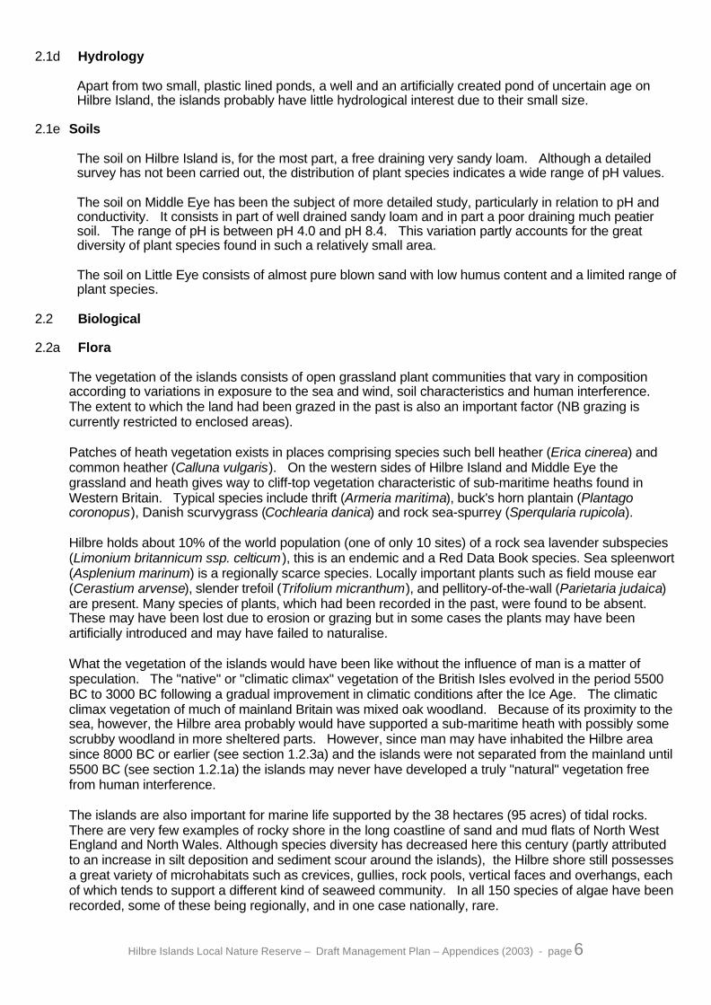
2.1d Hydrology
Apart from two small, plastic lined ponds, a well and an artificially created pond of uncertain age onHilbre Island, the islands probably have little hydrological interest due to their small size.
2.1e Soils
The soil on Hilbre Island is, for the most part, a free draining very sandy loam. Although a detailedsurvey has not been carried out, the distribution of plant species indicates a wide range of pH values.
The soil on Middle Eye has been the subject of more detailed study, particularly in relation to pH andconductivity. It consists in part of well drained sandy loam and in part a poor draining much peatiersoil. The range of pH is between pH 4.0 and pH 8.4. This variation partly accounts for the greatdiversity of plant species found in such a relatively small area.
The soil on Little Eye consists of almost pure blown sand with low humus content and a limited range ofplant species.
2.2 Biological
2.2a Flora
The vegetation of the islands consists of open grassland plant communities that vary in compositionaccording to variations in exposure to the sea and wind, soil characteristics and human interference.The extent to which the land had been grazed in the past is also an important factor (NB grazing iscurrently restricted to enclosed areas).
Patches of heath vegetation exists in places comprising species such bell heather (Erica cinerea) andcommon heather (Calluna vulgaris). On the western sides of Hilbre Island and Middle Eye thegrassland and heath gives way to cliff-top vegetation characteristic of sub-maritime heaths found inWestern Britain. Typical species include thrift (Armeria maritima), buck's horn plantain (Plantagocoronopus), Danish scurvygrass (Cochlearia danica) and rock sea-spurrey (Sperqularia rupicola).
Hilbre holds about 10% of the world population (one of only 10 sites) of a rock sea lavender subspecies(Limonium britannicum ssp. celticum ), this is an endemic and a Red Data Book species. Sea spleenwort(Asplenium marinum) is a regionally scarce species. Locally important plants such as field mouse ear(Cerastium arvense), slender trefoil (Trifolium micranthum), and pellitory-of-the-wall (Parietaria judaica)are present. Many species of plants, which had been recorded in the past, were found to be absent.These may have been lost due to erosion or grazing but in some cases the plants may have beenartificially introduced and may have failed to naturalise.
What the vegetation of the islands would have been like without the influence of man is a matter ofspeculation. The "native" or "climatic climax" vegetation of the British Isles evolved in the period 5500BC to 3000 BC following a gradual improvement in climatic conditions after the Ice Age. The climaticclimax vegetation of much of mainland Britain was mixed oak woodland. Because of its proximity to thesea, however, the Hilbre area probably would have supported a sub-maritime heath with possibly somescrubby woodland in more sheltered parts. However, since man may have inhabited the Hilbre areasince 8000 BC or earlier (see section 1.2.3a) and the islands were not separated from the mainland until5500 BC (see section 1.2.1a) the islands may never have developed a truly "natural" vegetation freefrom human interference.
The islands are also important for marine life supported by the 38 hectares (95 acres) of tidal rocks.There are very few examples of rocky shore in the long coastline of sand and mud flats of North WestEngland and North Wales. Although species diversity has decreased here this century (partly attributedto an increase in silt deposition and sediment scour around the islands), the Hilbre shore still possessesa great variety of microhabitats such as crevices, gullies, rock pools, vertical faces and overhangs, eachof which tends to support a different kind of seaweed community. In all 150 species of algae have beenrecorded, some of these being regionally, and in one case nationally, rare.

Hilbre Islands Local Nature Reserve – Draft Management Plan – Appendices (2003) - page 7
2.2b Fauna
The Hilbre Islands, particularly Little Eye and Middle Eye, are a roost site for internationally importantwading birds wintering in the Dee Estuary. The most common species are knot, dunlin, redshank,turnstone, sanderling and oystercatcher. Most of the wading birds feed on the plentiful supply ofinvertebrates concentrated in the alluvial sediments of the estuary. A few waders, however, notably thepurple sandpiper, feed on invertebrates from the seaweed covered rocks surrounding the Hilbre Islands.These islands become particularly important roost sites on high spring tides and in storm conditionswhen other roost sites in the estuary (beach and saltmarsh) are completely covered. The islands can becarpeted with waders at these times.
The islands are also an important staging post for migrating passerine (i.e. perching) birds during bothspring and autumn. These feed on the invertebrate population of the island plateaux before setting offon the next leg of their journeys. As with the waders, the main attraction of the islands is probably theirstrategic position and the fact that the birds are relatively undisturbed.
The Hilbre Bird Observatory was formed in 1957. Detailed observations of birds have been made sincethat time and about 1,000 birds are ringed annually. In all, 223 species have been recorded on theislands.Full details of observations including frequencies of sightings are given in the annual Hilbre BirdObservatory Reports and Chapter 12 of Hilbre, The Cheshire Island edited by J.D. Craggs (1982).
Despite the large numbers of birds observed on the Hilbre Islands there have only been five specieswhich have nested regularly on the islands in recent years. These are skylark, meadow pipit, starling,linnet and shelduck. Whilst these species are all fairly common the islands do present an interestingopportunity for the study of isolated breeding colonies. Skylark and Linnet are National BiodiversityPriority species. A detailed study has been made of the house sparrows on the island. pied wagtail, wrenand robin
The islands contain one of the most studied populations of invertebrate fauna in the North West ofEngland. There are over 700 species (mainly insects). The distribution of species is related to thevegetation type, tolerance of sea spray and the incidence of occasional inundation by waves. Some ofthe species found in the heath and open grassland plant communities are regionally rare but most ofthose in the paddock and garden areas are locally common. The spider and harvestmen populationsare similar to those found on mainland heaths, such as Thurstaston Common, whilst the land molluscsare common or garden varieties.
The only mammals that regularly breed on the islands are field voles. Many other mammals have beenobserved, having crossed from the mainland, these include rabbits, hedgehogs, foxes, stoats, rats, mice,otters, a grey squirrel and even a fallow deer which was thought to have crossed the River Dee fromNorth Wales.
The Hilbre Islands are of particular interest as a platform from which to observe grey seals, eitherswimming around the islands or on the West Hoyle Bank to the west of Hilbre Island which the sealshave used as a haul-out site for the last 70 years. The colony which numbers over 500 at their annualmaximum, spends most of the year around the mouth of the Dee and is considered to be of regionalinterest. Most return to their breeding grounds in Autumn. One of the possible breeding grounds isthought to be Ramsey Island off the coast of Pembrokeshire. Additionally rare sitings are made onoccasions of common seals and species of porpoises, dolphins and whales. The Dee Estuary is alsoestimated to support 93 species of fish including the uncommon anadromous fish, smelt, Osmeruseperlanus.
The status of the marine fauna is consistent with that of the marine flora, see above.

Hilbre Islands Local Nature Reserve – Draft Management Plan – Appendices (2003) - page 8
2.2c Ecological Relationships
These islands represent the only natural hard rocky coast within the estuary and are the only examplesof this habitat between the limestone cliffs of the Creuddyn Peninsula in North Wales and the sandstonecliffs of St Bees Head in Cumbria. The supporting vegetation i.e. maritime heathland/grassland and hardcliff/ledge vegetation are thus of significant interest.
The ecological communities on the islands include two major and largely separate habitats. One is aform of dry maritime heath and grassland on the plateau areas and the other is the tidal rocky shore.They can in turn be sub-divided into numerous micro-habitats where different species of flora and faunapredominate in response to variations in the degree of exposure to sea, salt, wind, trampling and (on theplateaux) grazing and cultivation. In both habitats the invertebrate fauna and mollusc populationsappear to be closely related to the types of plant communities present.
The islands' only resident land mammal, the field vole, is commonly found in rough ungrazed grasslands.Its numbers were found to fall during one recent period of intensive stock grazing. Another controllingfactor has been the arrival of kestrels on two occasions when the vole population has become abundant.The kestrels disappear again when the vole population falls. The resident bird population of shelduck,skylarks, blackbirds, meadow pipits, pied wagtails, starlings and linnets are also suited to the islandhabitat, but they are limited by their resilience to human interference and availability of food.
The wading birds that use the islands as a high tide roost feed mainly on invertebrate fauna in the tidalsands of the estuary. Their relationship with the ecology of the islands is not fully understood.
Similarly, it is not clear what effect, if any, the large numbers of migrating passerine birds have on theflora and other fauna of the islands. To the waders and the migrating passerines the islands areprimarily a resting place for which purpose the islands are strategically located and relatively free fromhuman disturbance.
The seals that use the West Hoyle Bank as a haul-out site feed on the fish of the Irish Sea and the DeeEstuary. The West Hoyle Bank has probably been selected for the accessibility it affords to theirfeeding grounds, shelter from the prevailing westerly winds and its relative safety from humaninterference.
It is difficult to determine precisely the influence of man in the ecology of the islands. He has had someinfluence on the islands for as long as 10,000 years. He has farmed and grazed the islands with stockfor over 1000 years and has visited the islands in large numbers for 100 years. Even those areas thatappear at first glance to be "natural" are in fact the result to a certain extent of earlier farming or grazingpractices.
Through the building of the Lifeboat Station and extensive revetment work, man has prevented someparts of Hilbre Island from erosion by the sea. Conversely, by the quarrying of other areas the erosionprocess has been accelerated.
By growing various crops, grazing various animals and gardening, man has influenced the range ofplants that grow on the islands. Some species of flora and fauna have been deliberately introduced,whilst others have arrived accidentally.
Overgrazing and excessive trampling by visitors in sensitive areas can cause the destruction ofvegetation and accelerate erosion, while the disturbance of roosting birds, by recreational users candeplete the birds' energy reserves and reduce their ability to survive the Winter.

Hilbre Islands Local Nature Reserve – Draft Management Plan – Appendices (2003) - page 9
2.3 Cultural
2.3a Archaeology
Archaeological finds from the Hilbre Islands and from the mainland at Hoylake and Meols suggest thatman was already present in this area during the period 8000 BC to 5000 BC. Numerous "finds" havebeen made on the islands, mainly by chance excavations or through the action of erosion by the sea,although no systematic survey has been conducted. The most thorough excavation was conducted byProfessor Newstead of Liverpool University in 1926 and consisted of ten small trenches dug on HilbreIsland.
A full list of archaeological finds on the islands is given below in section 5. The most notable findsinclude a bronze axe-head found on Middle Eye and thought to be of Irish origin and a Saxon orNorman burial ground covering a quarter of an acre on Hilbre Island.
2.3b Land Use History
Hilbre Island is known to have had religious associations from an early date. A stone cross-head andgrave cover found in the mid nineteenth century are considered to date from the late tenth or earlyeleventh century. A pilgrim shrine may have existed at an even earlier date, dedicated to StHildeburgh or St Edburge, a seventh century Mercian Saint.
In 1066, Hilbre Island was part of the manor of Caldy, held by the Englishman Leofnoth. William theConqueror gave Leofnoth's lands to Hugh of Avranches who passed them on to his follower Robert ofRhuddlan. Some time prior to 1081 he, in turn, gave them to the Abbey of St Evroul in Normandy.
In 1140 St Everoul transferred Kirby and Hilbre to their Benedictine Brethren at St Werburgh's, Chesterand a Benedictine cell of monks was maintained on the island until its dissolution in 1538.
During the later years of the Benedictine cell it is known that two monks lived on Hilbre Island with theirservant. They had one or two small boats and fished for herrings and they had a miniature farm on theisland with horses, cattle and sheep and they may have grown herbs for medicinal use.
In 1538 the islands passed to the Dean and Chapter of Chester Cathedral and remained under thisownership until 1856. It was no longer a place of worship but simply a piece of property which wasleased to various people over the years.
In the sixteenth and early seventeenth century Hilbre Island was an important anchorage for shipping inthe Dee Estuary. Most of the trade was with Ireland (usually Dublin). Outward cargoes includedvarious types of cloth, manufactured articles such as nails, knives, cups, wooden plates, smallquantities of sugar, raisins, pepper and occasionally coal from the Deeside seams. The returncargoes consisted predominantly of hides for Chester's flourishing leather industry.
Hilbre Island was also used as an embarkation point for shipping troops, horses and equipment toIreland during Elizabeth 1's Irish wars and again during Cromwell's Irish campaign. During this periodthe island probably contained an inn and one or two houses. The residents probably kept a pony, acow and some sheep.
From the early seventeenth century onwards the importance of Hilbre island as an anchorage declined.This was partly due to the increasing size of boats used for trade and partly due to the gradual siltingup of the channel between Hilbre Island and Hoylake.
In 1692 there was a scheme to produce salt on Hilbre Island. This probably involved boiling inseawater quantities of Cheshire rock salt brought to the island via. the River Dee. The scheme wasshort-lived but may well have left some traces in the form of depressions in the ground outside thepresent bird observatory. In 1755 there was a proposal to establish an oyster fishery around the islandbut this was opposed by a combination of Liverpool Corporation, traders, shipowners, fishermen andpilots and the proposal was dropped.
The island's inn "The Seagull Inn" was first recorded in 1793. Its patrons were "the crews of somesmall vessels which find a harbour under one side of the Island".
Hilbre Islands Local Nature Reserve – Draft Management Plan – Appendices (2003) - page 10
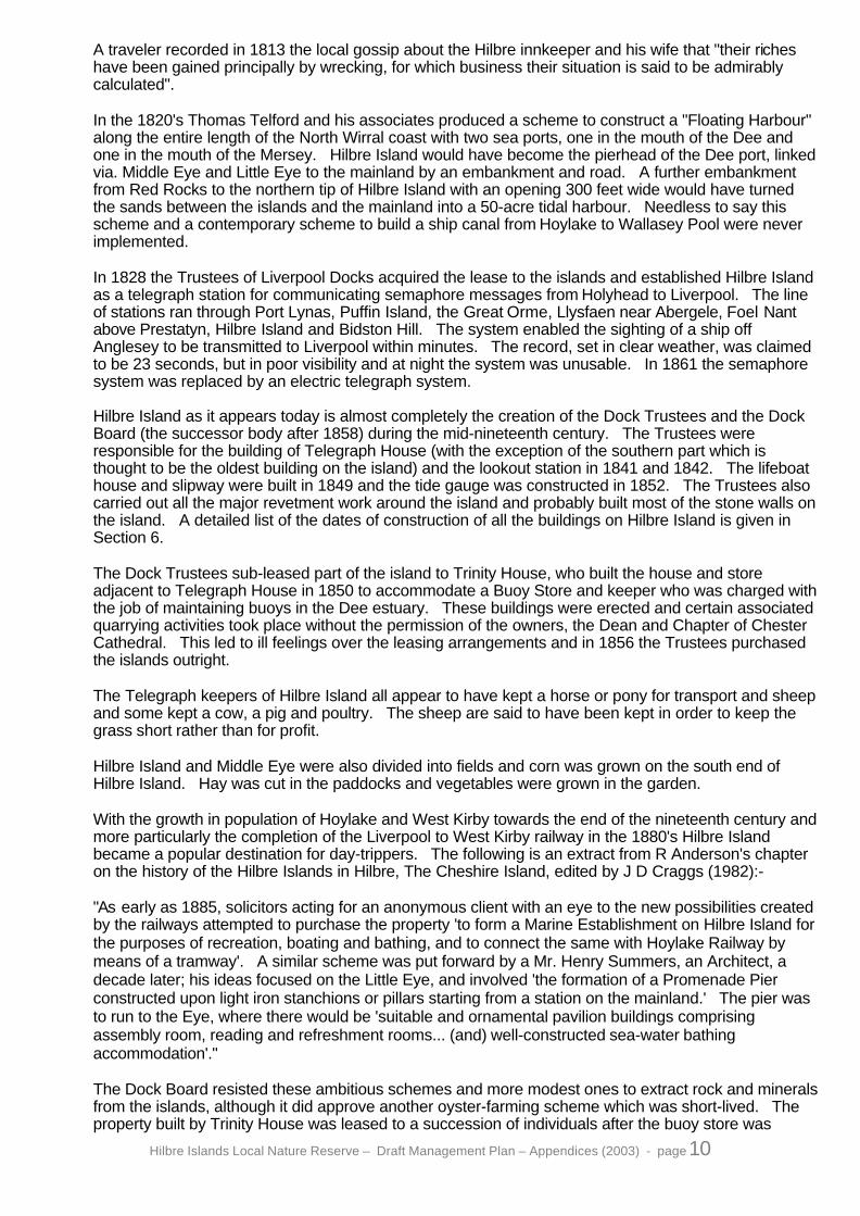
A traveler recorded in 1813 the local gossip about the Hilbre innkeeper and his wife that "their richeshave been gained principally by wrecking, for which business their situation is said to be admirablycalculated".
In the 1820's Thomas Telford and his associates produced a scheme to construct a "Floating Harbour"along the entire length of the North Wirral coast with two sea ports, one in the mouth of the Dee andone in the mouth of the Mersey. Hilbre Island would have become the pierhead of the Dee port, linkedvia. Middle Eye and Little Eye to the mainland by an embankment and road. A further embankmentfrom Red Rocks to the northern tip of Hilbre Island with an opening 300 feet wide would have turnedthe sands between the islands and the mainland into a 50-acre tidal harbour. Needless to say thisscheme and a contemporary scheme to build a ship canal from Hoylake to Wallasey Pool were neverimplemented.
In 1828 the Trustees of Liverpool Docks acquired the lease to the islands and established Hilbre Islandas a telegraph station for communicating semaphore messages from Holyhead to Liverpool. The lineof stations ran through Port Lynas, Puffin Island, the Great Orme, Llysfaen near Abergele, Foel Nantabove Prestatyn, Hilbre Island and Bidston Hill. The system enabled the sighting of a ship offAnglesey to be transmitted to Liverpool within minutes. The record, set in clear weather, was claimedto be 23 seconds, but in poor visibility and at night the system was unusable. In 1861 the semaphoresystem was replaced by an electric telegraph system.
Hilbre Island as it appears today is almost completely the creation of the Dock Trustees and the DockBoard (the successor body after 1858) during the mid-nineteenth century. The Trustees wereresponsible for the building of Telegraph House (with the exception of the southern part which isthought to be the oldest building on the island) and the lookout station in 1841 and 1842. The lifeboathouse and slipway were built in 1849 and the tide gauge was constructed in 1852. The Trustees alsocarried out all the major revetment work around the island and probably built most of the stone walls onthe island. A detailed list of the dates of construction of all the buildings on Hilbre Island is given inSection 6.
The Dock Trustees sub-leased part of the island to Trinity House, who built the house and storeadjacent to Telegraph House in 1850 to accommodate a Buoy Store and keeper who was charged withthe job of maintaining buoys in the Dee estuary. These buildings were erected and certain associatedquarrying activities took place without the permission of the owners, the Dean and Chapter of ChesterCathedral. This led to ill feelings over the leasing arrangements and in 1856 the Trustees purchasedthe islands outright.
The Telegraph keepers of Hilbre Island all appear to have kept a horse or pony for transport and sheepand some kept a cow, a pig and poultry. The sheep are said to have been kept in order to keep thegrass short rather than for profit.
Hilbre Island and Middle Eye were also divided into fields and corn was grown on the south end ofHilbre Island. Hay was cut in the paddocks and vegetables were grown in the garden.
With the growth in population of Hoylake and West Kirby towards the end of the nineteenth century andmore particularly the completion of the Liverpool to West Kirby railway in the 1880's Hilbre Islandbecame a popular destination for day-trippers. The following is an extract from R Anderson's chapteron the history of the Hilbre Islands in Hilbre, The Cheshire Island, edited by J D Craggs (1982):-
"As early as 1885, solicitors acting for an anonymous client with an eye to the new possibilities createdby the railways attempted to purchase the property 'to form a Marine Establishment on Hilbre Island forthe purposes of recreation, boating and bathing, and to connect the same with Hoylake Railway bymeans of a tramway'. A similar scheme was put forward by a Mr. Henry Summers, an Architect, adecade later; his ideas focused on the Little Eye, and involved 'the formation of a Promenade Pierconstructed upon light iron stanchions or pillars starting from a station on the mainland.' The pier wasto run to the Eye, where there would be 'suitable and ornamental pavilion buildings comprisingassembly room, reading and refreshment rooms... (and) well-constructed sea-water bathingaccommodation'."
The Dock Board resisted these ambitious schemes and more modest ones to extract rock and mineralsfrom the islands, although it did approve another oyster-farming scheme which was short-lived. Theproperty built by Trinity House was leased to a succession of individuals after the buoy store was

Hilbre Islands Local Nature Reserve – Draft Management Plan – Appendices (2003) - page 11
discontinued in 1876. A lease was granted for the construction of a clubhouse for the Mersey CanoeClub in 1896 and leases were also granted for the construction of holiday bungalows in 1897, 1905,1908 and 1923.
The Dock Board and their various tenants became increasingly concerned at the number of day-trippers. August Bank Holiday of 1911 brought 2,000 visitors. There were a number of attempts toprevent public access but the public outcry was such that the Dock Board eventually settled on amethod of controlling the number of visitors by issuing tickets that had to be obtained in advance.Even this system was not introduced without local opposition. As an aid to control, iron railings andgates were erected around Hilbre Island and Middle Eye in 1911 and a Dock Board Policeman wasemployed on Sundays to enforce regulations.
During the First World War Hilbre Island was occupied by the Army. During the Second World War itwas occupied by the RAF who used the islands as part of a decoy system to try and confuse enemybombers attacking Liverpool. The use of the lifeboat station and Telegraph Station was continued in1939, the railings gradually disintegrated from neglect and disappeared and an air-raid shelter was builtin the middle of the Island.
In 1945 the islands were sold to Hoylake Urban District Council with a number of covenants designedto safeguard them from undesirable development.
In 1974 when local government was reorganised, Hoylake UDC considered handing over the islands tothe National Trust. The newly elected Wirral Borough Council, however, placed on record itsdetermination to pursue a policy safeguarding the islands from undesirable development and topreserve and maintain their character for the enjoyment of the public (Leisure Services CommitteeMinute 13 - 29.5.1974).
Since 1945 the only developments have been the construction of the former bird observatory hut in1962 and the adaptation of the lifeboat station in 1975 to make a "sea-watching" hide for ornithologists.The Local Authorities have appointed a succession of Custodians to live in Telegraph House and tolook after the interests of the islands. They have kept a variety of animals including a horse, ponies,goats, chickens, geese and turkeys, although there has been no grazing of the unenclosed areas of theislands since 1976.
In 1985 the post of Custodian was changed to Countryside Ranger with wider responsibility for the DeeEstuary.
2.3c Public Interest
For over a hundred years the Hilbre Islands have attracted large numbers of visitors each year. Mostpeople visit the islands during the Summer for an afternoon's or even a day's outing. They visit theislands for a walk, to see the sea and the rock pools, to sunbathe or to picnic. Some walk there andback at low tide, whilst others stay on the islands for the high tide and return as the tide recedes.
Many people are attracted to the islands through an interest in natural history and much scientificresearch has been carried out over the past century on both the marine and terrestrial life of theislands, particularly under the auspices of Liverpool University. Large numbers of primary andsecondary school parties also visit the islands in connection with specific projects or for a generaleducational outing.
The value of the islands for bird watching has long been appreciated but the Hilbre Island BirdObservatory was not established until 1957 and did not acquire permanent premises until 1962. TheObservatory is run by a group of keen amateur ornithologists for the purposes of recording and ringingthe birds found on and around the islands. There has been a marked increase in the number of birdwatchers visiting the islands in recent years. In particular, there has been an increase in the numberof large organised parties visiting the islands in Winter. This increase is mostly due to the generalgrowth in popularity of bird watching nationally, but it is also partly due to the existence of the birdobservatory and the interest taken in the islands by top professional bird photographers, such as EricHoskings.

Hilbre Islands Local Nature Reserve – Draft Management Plan – Appendices (2003) - page 12
The energy sources on Hilbre Island have inspired a number of projects in the field of mechanicalengineering. The Institute of Oceanographic Sciences and Liverpool University have investigatedvarious aspects of tidal flow, wind energy and solar energy.
During high tides the waters around the islands are popular for sailing, canoeing and windsurfing. TheMersey Canoe Club is the only water sport club with a permanent base on the islands. It has had itspresent clubhouse on Hilbre Island since 1896.
Some of the local sailing clubs do, however, use the island from time to time in connection with sailingevents. There are six sailing clubs based on the Dee and the North Wirral coasts active in this areawith a total of about 2,700 members and 816 boats (in 1983).
A regular but fairly small number of people use the surrounding shores for fishing, bait digging andcollecting shellfish (mainly cockles, mussels and whelks). An enquiry was made about the possibilityof establishing an oyster farm at the north end of Hilbre Island as recently as 1981.
2.3d Past Management
No attempt was made to control public access to the islands until the 1870's when a Mr. Brandrethleased the southern part of Hilbre Island from the Dock Board. His attempts were largely ignored bythe local residents of West Kirby. In 1888 the following tenant, Mr. Rundell, closed off Hilbre Island byerecting a locked gate across the path. This produced a local outcry. The local residents claimedthere was a public right of way across the island that dated back to the existence of the public houseand even to the days of mediaeval pilgrimages to the island. The Dock Board refused to recognise theexistence of a public right of way but, in response to pressure from the local residents, the LocalAuthority and the local newspapers agreed to permit the public to visit the island as before.
Over the next few years the numbers of visitors grew to such an extent that the Dock Board itself feltobliged to introduce some measure of control. Litter, broken glass and rowdyism became increasingproblems not only for the Dock Board and the inhabitants of Hilbre Island but also for the majority ofrespectable visitors. Litter bins were provided in 1900 but a request by Hoylake UDC for the DockBoard to provide public toilets in 1910 was turned down. The Board considered closing the islandsaltogether on Sundays and Bank Holidays but settled instead on the use of tickets which had to beobtained in advance. This system was introduced in 1911 and Hilbre Island and Middle Eye werefenced with iron railings to facilitate enforcement. The Telegraph Keeper was made responsible forchecking tickets but had assistance from Dock Board Police on busy Sundays and Bank Holidays.
Despite initial complaints from local residents, the ticket system of control was generally accepted asbeing in the public interest. The system has continued, with slight modifications, up to the present day.The twin system of annual permits for individuals and groups of up to 5, and day permits for groups ofover 5 but no more than 50 was modified in the early 1990's, when the individual or annual permit wasabandoned, but the group day permit was retained. At the present time, a group permit which is validfor one day only and covers a maximum of 50 people is required. More than one group may visit theisland on any one day provided the total number of people visiting in groups does not exceed 50.Permits are available from Wirral Country Park Visitor Centre, Thurstaston. Permits are no longeravailable from West Kirby Concourse, although an outlet in West Kirby is still considered to be the ideallocation for the permits to be issued in the future. (See Appendix 4)
It is almost impossible to estimate how many visits were made without permits. In 1975 153 grouppermits and 452 individual permits were issued.
In 1981 104 group permits were issued. The total number of visitors in these groups was 2,750. Theaverage party size was therefore 26. The number of individual permits issued was 470. As thesepermits are valid for a calendar year and for groups of up to give people, it is impossible to estimateaccurately how many authorised visits were made without further research. There has likely been afall in the number of visits over this period.
Vehicles are only authorised on the islands or the foreshore under special circumstances. Theunauthorised use of motor vehicles, including motorbikes on the foreshore has increased in recentyears.
Hilbre Islands Local Nature Reserve – Draft Management Plan – Appendices (2003) - page 13
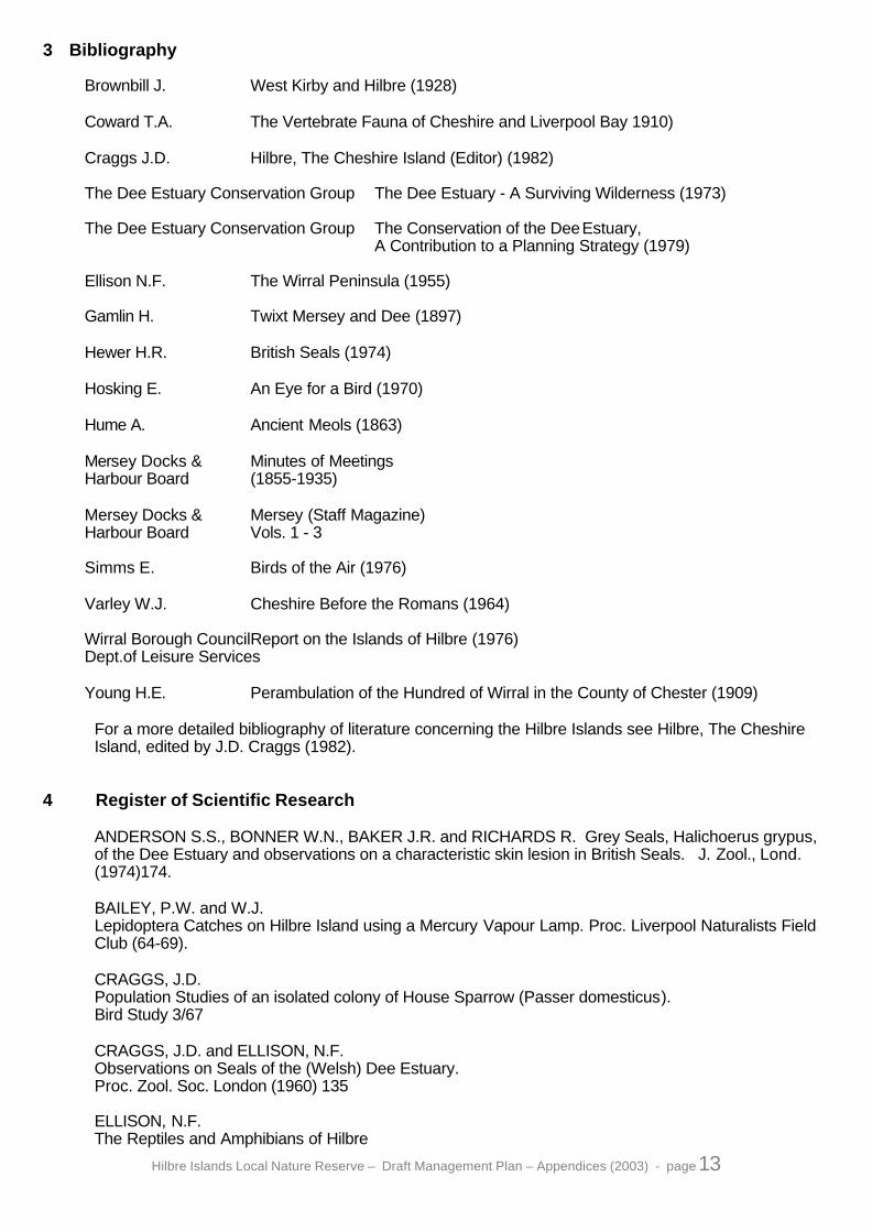
3 Bibliography
Brownbill J. West Kirby and Hilbre (1928)
Coward T.A. The Vertebrate Fauna of Cheshire and Liverpool Bay 1910)
Craggs J.D. Hilbre, The Cheshire Island (Editor) (1982)
The Dee Estuary Conservation Group The Dee Estuary - A Surviving Wilderness (1973)
The Dee Estuary Conservation Group The Conservation of the DeeEstuary,A Contribution to a Planning Strategy (1979)
Ellison N.F. The Wirral Peninsula (1955)
Gamlin H. Twixt Mersey and Dee (1897)
Hewer H.R. British Seals (1974)
Hosking E. An Eye for a Bird (1970)
Hume A. Ancient Meols (1863)
Mersey Docks & Minutes of MeetingsHarbour Board (1855-1935)
Mersey Docks & Mersey (Staff Magazine)Harbour Board Vols. 1 - 3
Simms E. Birds of the Air (1976)
Varley W.J. Cheshire Before the Romans (1964)
Wirral Borough CouncilReport on the Islands of Hilbre (1976)Dept.of Leisure Services
Young H.E. Perambulation of the Hundred of Wirral in the County of Chester (1909)
For a more detailed bibliography of literature concerning the Hilbre Islands see Hilbre, The CheshireIsland, edited by J.D. Craggs (1982).
4 Register of Scientific Research
ANDERSON S.S., BONNER W.N., BAKER J.R. and RICHARDS R. Grey Seals, Halichoerus grypus,of the Dee Estuary and observations on a characteristic skin lesion in British Seals. J. Zool., Lond.(1974)174.
BAILEY, P.W. and W.J.Lepidoptera Catches on Hilbre Island using a Mercury Vapour Lamp. Proc. Liverpool Naturalists FieldClub (64-69).
CRAGGS, J.D.Population Studies of an isolated colony of House Sparrow (Passer domesticus).Bird Study 3/67
CRAGGS, J.D. and ELLISON, N.F.Observations on Seals of the (Welsh) Dee Estuary.Proc. Zool. Soc. London (1960) 135
ELLISON, N.F.The Reptiles and Amphibians of Hilbre

Hilbre Islands Local Nature Reserve – Draft Management Plan – Appendices (2003) - page 14
Proc. Liverpool Naturalists Field Club (64-69)
ELLISON, N.F.The Land and Marine Animals of HilbreProc. Lancs. & Chesh. Fauna Soc. 1970
FENTON, C.Spiders and Harvestmen of HilbreLancs. & Chesh. Fauna Soc. 1972 No. 61
HARDING, P.T.A collection of Woodlice and Beetles on HilbreHilbre Island Bird Report 1968
HARRIS, J.H. & YOUNG J.O.The invertebrate Fauna of the Pond on HilbreHilbre Island Bird Report 1972
HILBRE BIRD OBSERVATORY Reports 1957 - 2000
McMILLAN, N.F.A Kitchen Midden on HilbreProc. Liverpool Nat. Field Club 1942McMILLAN, N.F.Marine Mollusca of HilbreProc. Liverpool Nat. Field Club 1941
McMILLAN, N.F.An Island Fauna (Hilbre, Chesh)Journal of Conchology (1964) 25
MEREDITH, S.S.A Study of Cragnon Vulgaris in the Liverpool Bay AreaProc. Liverpool Biol. Soc. (1950-52) LV 111
RUSSEL, G.Algal Vegetation of HilbreHilbre Island Bird Report 1968 and 1970
RUSSEL, G.Phytosociological Studies on a two zone shore.J. Ecol (1972) 60
TAYLOR, G.H.Flowering Plants and Ferns of HilbreHilbre Island Bird Report 1971-1972
A more comprehensive and up to date register of research work on the flora and fauna of the HilbreIslands can be found in Hilbre, The Cheshire Island, edited by J.D. Craggs (1982).
5 Archaeology
The reported archaeological finds from the Is lands are arranged below by period based on informationsupplied by the Liverpool Museum. The 19th century writers were rarely precise about where objectswere found and some more recent writers have attributed earlier discoveries to the wrong island.
As far as possible all the references have been checked. The majority of the objects found went to theCheshire Archaeological Society's collections (The Grosvenor Museum, Chester).
See end for bibliography. 'No location' means present whereabouts are not known.

Hilbre Islands Local Nature Reserve – Draft Management Plan – Appendices (2003) - page 15
Prehistoric Period
Hilbre Island:
a) Neolithic stone axehead reported found in 1950's. No details and no location.
b) Neolithic flint arrowhead (TrHS 25).
c) Flint arroweheads and flakes found by C Potter mid-19th century, now in the Grosvenor Museum.
Middle Eye:
a) Bronze socketed axe found in 1926, probably Irish and one of very few from the north west. Nolocation. (Varley fig. 20, N & TrHS 78).
b) Fragments of a bucket-shaped urn found in 1965 where part of the cliff had collapsed, now in theGrosvenor Museum.
Little Eye:
a) A possible Mesolithic working platform, the flints 'are washed out from theremains of a rapidly diminishing bank ... & in the face of which examples may at
times be found protruding'. No location. (TrHS 23p. 127)
b) Three Neolithic arrowheads and nine scrapers. (TrHS 25p. 127)
c) Ten Neolithic arrowheads and scrapers, possibly Irish, with waste material (TrHS 24p. 142).
Roman Period
(All finds from the Roman Period onwards are said to be from Hilbre Island).
a) Sherds of 3rd and 4th century pottery found in 1926 by Newstead, at Grosvenor Museum (TrHS78p. 136)
b) Two bronze brooches, bronze buckles and glass beads, probably to Liverpool Museum but unlocated. (TrHS vol 23p. 20).
c) H E Smith records himself as first to recognise Roman objects on Hilbre. He does not detail thembut says many were picked up by the telegraph keeper. (TrHS 20p. 101).
Saxon Period
a) Anglo-Norse crosshead found in 1853, early 11th century, now in Grosvenor Museum (TrHS 23p. 29; TrHS 15p. 233; TrHS 78p. i).
b) Some of the items described as Roman in TrHS sound more likely to be Saxon in date, no location.(TrHS 18p. 210, 20p. 106 and 115, 23p. 127).
Medieval Period
a) In 1864 a late 11th or early 12th century grave slab discovered. Now in Charles Dawson Museumattached to St Bridget's West Kirby. (TrHS 23p. 30). There were also said to be a number of burialsnearby.
b) Kitchen midden of 14-15th century (North Western Naturalist 1953-54 p. 388).
c) Elizabethan coin, Irish 1602, Grosvenor Museum.
d) Medieval lead object inscribed AVE MARIA, to Liverpool, but unlocated. (TrHS 20p. 121).

Hilbre Islands Local Nature Reserve – Draft Management Plan – Appendices (2003) - page 16
e) Medieval pottery (TrHS 21p. 215).
f) Two 16th century reckoning counters (TrHS 26p. 102-3).
Post-Medieval Period
a) Midden site of late 18-19th century (N.W. Nat. 1953-54)
b) Clay pipes of 17th and 18th centuries, now in Liverpool Museum.
c) The Lifeboat House, Lighthouse and self-registering tide gauge etc.
Other Items
a) Three flints from Hilbre beach (TrHS 18); Two arrowheads (TRHS 20) and 23 worked flints with 10 flakes (TrHS 25p. 128) all said to be from the beach.
b) 13th century lead pilgrim's badge from France, to Liverpool Museum but unlocated (TrHS 23p. 31).
c) There was a light on the Islands somewhere from at least Henry III's reign (1216 - 1272) becausethe Earl of Chester had to contribute ten shillings a year for its upkeep.
Objects or Structures of Uncertain Date
Hilbre Island
a) Burial ground of about .25 acre, presumably associated with the Saxon or Norman chapel.
b) Kitchen Midden (NW Nat. 1953-54 p.388)
c) Salt workings (TRHS 20p. 126)
d) Well 40 feet deep
e) Circular buildings possibly associated with the salt workings (TrHS 21p. 216).
f) Unglazed pottery, probably Roman or Medieval. (TrHS 25p. 134).
g) Rock-cut feature. (TrHS 23p. 219 and TrHS 78p. 141)
Middle Eye
Field boundaries of unknown date can be made out although the banks are being rapidly eroded.These may be associated with Bronze Age settlement, or with the religious foundation.
Little Eye
A kitchen midden reported by Newstead (TrHS 78).
Bibliography
References to Hilbre Island occur in the following volumes of the Transactions of the Historical Societyof Lancashire and Cheshire (TrHS); 15; 16; 18p. 205 and p. 210; 20pp. 101, 104, 106, 115, 121,126; 21p. 215 and 216; 23pp. 13-46 and 127; 24p. 142 and 143; 25p. 127; 26p. 102-103; 27p. 95;78p. 136 - 143; and also Trans. Lanc's and Cheshire Archaeological Soc. vol. 68 (1958), 1-9.

Hilbre Islands Local Nature Reserve – Draft Management Plan – Appendices (2003) - page 17
6 Status of Buildings on Hilbre
The buildings which may be seen now on Hilbre Island are as follows, with their known or suggesteddates of construction based mainly on Dock Board records. The list is adapted from Hilbre, TheCheshire Island, edited by J D Craggs (1982) and begins at the south end of the island:
Bungalows 1 1924, (now Hilbre Bird Observatory)2 1908, (now demolished)3 1905,4 1897
Air-raid shelter of RAF 1939-45Shed in paddock, once incorporatingthe Saxon Cross 1880'sGreenhouse ruin Possibly late 19th centuryBuoy Store (now a dwelling) 1850Buoy Keeper's house 1850Southern Rooms of Telegraph Probably late 18th centuryKeeper's cottage, possibly part of Perhaps rebuilt from a formerthe former inn dwelling on the siteTelegraph Keeper's cottage 1841-2Telegraph Lookout 1841-2Pigsty 1846Bunkhouse )Barn and store ) probably 1840's and 1850'sCart shed, originally wooden)Boat Store by slipway ) possibly 1840's and 1850'sMersey Canoe Club 1897Hilbre Bird Observatory (former) 1962 (now demolished)Lifeboat House and slipway 1849Tide Gauge 1852-3Sea-watching Hide 1975
In addition, the masonry reinforcement of the cliffs around Hilbre was built between 1850 and 1896, theretaining wall of the south trackway in 1897 and the concrete bridge over the siphon cut for the tidegauge in 1908. There are no listed buildings on the island, although the Telegraph Lookout and theBuoy Keeper's House Buoy Store have been provisionally listed and the Department of theEnvironment has asked the Council to inform them of any proposals which may affect those buildingsprior to them being placed on the statutory list. The Department of the Environment describes thebuildings as follows:-
SJ 1888 HOYLAKE HILBRE ISLAND (east side)Buoy Master's House and Buoy Store
G.V. II
House and store, c.1836. Roughcast with slate roof. L-plan; house of 2 storeys and 3 bays withadjoining one-storey wing to left. Windows are sashed with glazing bars. Central entrance to househas overlight with glazing bars and 4-panel door. Wing for buoy storage etc. now mostly converted todomestic use has gable to end bay with small bell attached. Casement windows to south facade,sashes with glazing bars to north. Entrance with C20 porch and side entrance with paired doors tostore in end bay. 2 gable-end stacks to house, small stack to wing.
******************************SJ 1888 HOYLAKE HILBRE ISLAND (north west)
Telegraph StationG.V. II
Telegraph Station. 1841. For Liverpool Dock Trustees. Painted stone with slate roof. One storeywith bowed north end. Bowed end has small-paned glazing with 4 brass gimbals for telescopes. Eastfacade has timber platform and elliptical-headed entrance. Hipped south end. Built as part of a relayof 7 stations from Point Lynas to Liverpool transmitting information on merchant ships sailing toLiverpool.

Hilbre Islands Local Nature Reserve – Draft Management Plan – Appendices (2003) - page 18
7 Nature Conservation Designations of the Dee Estuary
Hilbre Islands LNR is part of the Dee Estuary, and as such is covered under a number of Nature ConservationDesignations. The descriptions/citations of the following designations are available from English Nature,or the Ranger on request
Dee Estuary Site of Special Scientific Interest (SSSI)Dee Estuary Special Protection Area (SPA),Dee Estuary candidate Special Area of Conservation (cSAC),Dee Estuary Ramsar Site
English Natures has a number of objectives for the SSSI.The following summarises those relevant to the Hilbre Islands LNR.
‘To maintain the habitats and the associated plants and animals that make the Dee Estuary of special interest.’• Maintain the internationally important populations of wintering and migratory birds by:
q Preventing the reduction due to human activities in the size of the populations for which the SPA hasbeen classified, as measured by rolling 5 year peak mean and average counts for the site carried outfor the site under the Wetland Bird Survey scheme (WeBS)
q Ensuring no significant loss in area, distribution or capacity of habitats which are part of the area whichsupports internationally important bird species, due to human activities.
• Maintain the range of plant communities and rare plant and invertebrate species.• Maintain and safeguard the geological interest of the Hilbre Islands.
8 Summary Data of Important Fauna
Figures are peak counts
1998 1999 2000 2001 2002 Meanlinnetskylark 0shelduckwrenmallardpied wagtailmeadow pipitrobin
Breedingbirds
swallowknotdunlinredshankbar-tailed godwitoystercatcherringed ploverpurple sandpipergrey ploverturnstonesanderlingcurlewbrent goose
NonBreedingbirds
cormorantfield voleMammalsatlantic grey seal 394 476 579 547
Non breeding birds (eg. passage and wintering birds) will have annual counts from August/September in theyear indicated up to and including March/April in the following year. These counts are a combination of HighWater counts from Hilbre and Middle Eye only; and Low Water counts, which will include birds from the entireWeBS (Wetland Bird Survey) Cell, which includes Little Eye and Tanskey Rocks.

Hilbre Islands Local Nature Reserve – Draft Management Plan – Appendices (2003) - page 19
9 Constraints of Tenure
The Metropolitan Borough of Wirral owns the Freehold title to the three Hilbre Islands and the tidal foreshorewithin the Local Nature Reserve as shown in appendix XXX. The three Hilbre Islands were purchased byHoylake Urban District Council from the Mersey Docks and Harbour Company on 18th December 1945 subjectto the following covenants.
“The purchaser hereby covenants with the Vendor that the Purchaser and its successors in title will henceforthobserve and perform the conditions following:
a) not use nor permit the use of the property for any industrial purposes or for the provision ofentertainment by means of swings, roundabouts, sideshows or similar or other amusements of afairground character;
b) use, hold and administer the property for recreational purposes to the end that the property may bepreserved for the enjoyment of the public under proper control and regulation and for no otherpurposes whatsoever;
c) make and enforce or cause to be made and enforced byelaws for the regulation of the propertyand for the preservation of order and the prevention of nuisance thereon;
d) not erect nor permit to be erected on the property any buildings or structures except such as maybe reasonably necessary to provide facilities for the public for shelter, bathing, boating,refreshment and sanitation, all such buildings or structures to be of suitable permanentconstruction and of a character unlikely adversely to affect the amenities of the district;
e) maintain and keep the property including all buildings and structures erected thereon at all times ingood order and condition.
Provided always that the Purchaser or its successors in title shall not be precluded from temporarilyclosing the property to the public for such period as it shall think fit for purposes connected with the betterpreservation of birdlife.”
The Mersey Docks and Harbour Board retained the right to keep on the islands a survey mark (now takenover by the Proudman Oceanographic Laboratory), navigation light (now the responsibility of trinity HouseLighthouse Authority), a Tide Gauge and any necessary buildings in connection with them. The Boardalso retained the right to visit the islands at any time in order to maintain or repair these facilities.
The foreshore surrounding the northerly part of Hilbre Island approximately north of a straight linebetween Hilbre Point and the Lighthouse at Point of Ayr (see maps in appendix 12) is subject to certainCrown reservations. Among other things these reservations effectively give the public “full and free right….. to walk or otherwise, pass to and fro over and to fish and bathe upon and to gather seaweed or ware…… and to land thereon goods and passengers from vessels and boats and to embark therefrom goodsand passengers in vessels and boats …..”
The public originally also had the “full and free right to ride (or) drive over this area of foreshore, but thisright was withdrawn in 1980 with the consent of the Crown Estate Commissioners. This was to preventpeople claiming the right to drive motor vehicles over the foreshore.
The foreshore to the south of a straight line between Hibre point and the lighthouse at Point of Ayre, (ie.Bounding the southern end of Hibre Island and surrounding Middle Eye and Little Eye) is not subject toany Crown reservations or covenants.
A number of areas and properties on Hibre Island are leased by the Council to private persons andassociations. These areas are shown on Maps in appendix 12.

Hilbre Islands Local Nature Reserve – Draft Management Plan – Appendices (2003) - page 20
Appendix 3
Evaluation of the features and potential of the site
Habitats
STATUSFEATURES International National Regional Local
PHYSICAL:
Geology; fossils, faults, pebble beds,crossbeddingGeomorphology; cliffs, stacks, caves,wave-cut platform
HABITATS:
Estuary (including mud/sand/shingle/cobbles/boulders/rocks, both intertidal and above the HW mark)
Maritime cliff & slope (including maritimeheathland/grassland and hard cliff/ledge vegetation)
Brackish pondPaddocks and gardensRock pools
High tide roost for wading birdsStopping-off point for migrating passerine birdsObservation point for grey seals
CULTURAL:
Archaeological findsHistoric buildings
EN
EN
EN
MBW
EN
EN
EN
LM
MBW
TCI
TCI
EN
GM
TCI
CDM
MBW
AUTHORITY:
EN: English Nature
TCI: Based on the relevant chapter of Hilbre, The Cheshire Island edited by J D Craggs
MBW: Metropolitan Borough of Wirral
LM: Liverpool Museum
CWT: Cheshire Wildlife Trust
GM: Grosvenor Museum, Chester
CDM: Charles Dawson Museum, St. Bridgets’s Church, West Kirby

Hilbre Islands Local Nature Reserve – Draft Management Plan – Appendices (2003) - page 21
Species
STATUSFEATURES International National Regional Local
MARINE ALGAE:
Chlorococcum submarinum (a species ofmicroscopic green algae found in a cave)
N.B. Many of the remaining 80 or so speciesof algae known to be present are of regionalimportance.
LAND MOSSES:
In general the few species of moss found onthe islands are common varieties. Most arefound in man-made habitats such as gardensand walls
LAND FLORA:
Cerastium arvense (fieldmouse ear)Trifolium micranthum (slender trefoil)Limonium britannicum ssp. celticum(rock sea lavender) RDBAsplenium marinum (sea spleenwort)Parietaria judaica (pellitory -of-the-wall)
N.B. Many other species of flora are of localsignificance.
LAND INVERTEBRATES:
Bledius unicornis (small horned staphylinidbeetle)Hadena rivularis (campion moth)Hadena confusa (marbled coronet moth)Eupithecia venosata (netted pug moth)Caenopsis waltoni (weevil)Polyxenus lagurus (small bristly millipede)Dytiscus circumflexus (brackish water divingbeetle)Telmatoscopus amiguus and labeculosus(moth midges)Montane BeeAll remaining species are common or of localimportance only.
CWT
TCI
*
CWT
TCI
TCI
TCI
TCI
*
TCI
TCITCI
TCI
*
CWTCWT
CWT
*
*
Hilbre Islands Local Nature Reserve – Draft Management Plan – Appendices (2003) - page 22
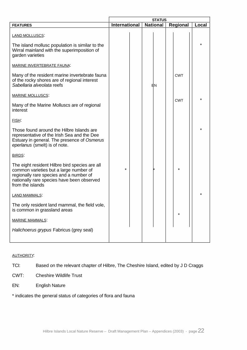
STATUSFEATURES International National Regional Local
LAND MOLLUSCS:
The island mollusc population is similar to theWirral mainland with the superimposition ofgarden varieties
MARINE INVERTEBRATE FAUNA:
Many of the resident marine invertebrate faunaof the rocky shores are of regional interestSabellaria alveolata reefs
MARINE MOLLUSCS:
Many of the Marine Molluscs are of regionalinterest
FISH:
Those found around the Hilbre Islands arerepresentative of the Irish Sea and the DeeEstuary in general. The presence of Osmeruseperlanus (smelt) is of note.
BIRDS:
The eight resident Hilbre bird species are allcommon varieties but a large number ofregionally rare species and a number ofnationally rare species have been observedfrom the islands
LAND MAMMALS:
The only resident land mammal, the field vole,is common in grassland areas
MARINE MAMMALS:
Halichoerus grypus Fabricus (grey seal)
*
EN
*
CWT
CWT
*
*
*
*
*
*
AUTHORITY:
TCI: Based on the relevant chapter of Hilbre, The Cheshire Island, edited by J D Craggs
CWT: Cheshire Wildlife Trust
EN: English Nature
* indicates the general status of categories of flora and fauna

Hilbre Islands Local Nature Reserve – Draft Management Plan – Appendices (2003) - page 23
Appendix 4
Hilbre Permit Scheme
The Hilbre Permit scheme was codfied in the 1986 Bylaws for Hilbre, see Appendix 8 for details.Initially all visitors to the Hilbre Islands Local Nature Reserve were required to have a permit; this wasamended in the early 1990's, because of problems for casual visitors obtaining a permit.In the long term, the solution proposed was to be to issue permits at an Information Centre at Dee LaneSlipway, West Kirby, however in the short term it was decided that individuals and groups of up to 5persons would not be required to have a permit. Groups of between 6 and 50 persons would require apermit for their particular day, available from Wirral Country Park Visitor Centre at Thurstaston. Groups ofover 50 persons not allowed to visit the reserve.
All individuals and groups of up to 5 persons, although no longer requiring a permit since 1992, are stillbound under the bylaws to adhere to the Conditions
A Code of Conduct is displayed on the Noticeboard at Dee Lane Slipway. This code summarises the mainconditions of the permit and the byelaws for visitors.
Hilbre Islands LNR – Guidelines for issuing Permits
Any group of over 5 persons needs a permit to visit any part of the reserve.
Area covered by the permit.The reserve is defined as all THREE islands and the rocks and rockpools surrounding them and the sandin between (see maps in appendix 13); it therefore includes the Little Eye and Middle Eye.
50/30 person limit.At any one time, only 50 persons are to be given a permit. This allows two or even three groups of 50 tovisit the reserve provided their visits do not overlap in time.
For groups comprised mostly of children, e.g. school, youth or church groups, we STRONGLY advise amaximum of 30 per group, as these require closer supervision. Ask them to contact the Hilbre Rangerabout their visit even if they say they don’t require a Ranger.
Ranger days off.Do not book groups consisting predominantly of children on the Hilbre Rangers day off unless anotherRanger is available to cover.
Visits over high water.Dissuade groups of mostly children visiting over high water; most get bored which can create problems.Don’t book groups in over high water on tides over 9.5 metres before clearing it with the Hilbre Ranger.
Photography/Hide bookingsRefer these straight to the Hilbre Ranger.
Overnight stays.These are not allowed.
Exceptions.It may be possible in some circumstances to issue a permit in addition to those allowed above. Thisdepends on the planned activity, and others visiting that day. Take their details and contact the HilbreRanger, or suggest they speak to the Hilbre Ranger before making their booking.Explain the value of thepermit, that it allows us to manage the groups visiting the reserve so that we can better protect thereserve against excessive disturbance, erosion, damage etc. and it is required by the Bylaws.

Hilbre Islands Local Nature Reserve – Draft Management Plan – Appendices (2003) - page 24
Appendix 5
Watersports Code of Conduct
A Watersports Code of Conduct would help deliver Objective 4.1 and Objective 1.3.Project 4.1.2 specifically targets the development of such a code. At the moment the followingsummarises the present state of development of a Watersports Code of Conduct.
In order to minimise the potential disturbance between the watersports use of the area around Hilbre andthe Wildlife value of the reserve, the following information was drawn up in consultation withrepresentatives from all sides of the issue.This information is made available in the form of posters and flyers at those times of year mostappropriate. The advice to sailors to avoid disturbing the seals is normally circulated around sailing clubsin late April. The advice on avoiding disturbance to birds is distributed mostly from September to the endof March. It must be noted that no specific code of conduct relating to landing on Hilbre outside the birdroosting season exists at the moment, this is something that may need clarifying when the codes ofconduct are re-assessed.It is envisaged that the former Dee Estuary Recreation Users Group if re-established, would play a keyrole in the future when these codes need re-assessing and publicising.
THANK YOUFOR AVOIDING WEST KIRBY BEACH,LITTLE EYE & THE HILBRE ISLANDS
FROM SEPTEMBER TO MARCH- it helps to save birdlife
The Dee Estuary is one of the North-VVest’s last surviving wildernesses. Its 10,000 acres of wetsands and mudflats support large populations of wading birds and wildfowl, particularly fromSeptember to March, making it a site of international importance.
The pursuit of watersports on tidal waters is exciting. However, enthusiasts are unintentionallyharming wading birds by disturbing them at their rest areas over high water.
Wading birds are vulnerable to disturbance. In winter the impact of flying unnecessarily can besevere, such is their need to build up and conserve energy. (They can even die, if a day ofunnecessary flying, instead of feeding and resting, is followed by a cold and windy night.) Inspring and autumn, constant disturbance can result in birds being too weak to migratesuccessfully.
If you are interested in finding out more about the Dee Estuary and its wildlife or have anycomments you wish to discuss, please contact Lynne Greenstreet, Coastal Ranger,Tel: (0151) 678 5488.
MetropolitanBorough of Wirral
Dee EstuaryVoluntaryWardens

Hilbre Islands Local Nature Reserve – Draft Management Plan – Appendices (2003) - page 25
BirdProtection Zones
Please keep clear of the Hilbre Islands, Little Eye and West Kirbybeach when sailing, windsurfing, kite-boarding, canoeing or jet-skiingon the tide.
Yellow buoys mark the closest points of approach (200 metres).
It is vital that wading birds are not disturbed in Autumn and Winter.
RedRocks
West Kirby Beach
MarineLake
NB.As this Management Plan was being finalised for public consultation, the bird protection zones werebeing extended due to an increase in disturbance, in particular by kite-surfers. Initial proposals are toextend the zones out to 500 metres, with a review following one winter season to determine if thishas been effective.

Hilbre Islands Local Nature Reserve – Draft Management Plan – Appendices (2003) - page 26
Seals and Boatingin the
Dee Estuary
The Dee Estuary by the Hilbre Islands ishome for a colony of Atlantic Grey Seals. Up to 500 individuals canregularly be seen in the area, especially as most haul out over lowwater on the south east corner of the West Hoyle Bank near to thegreen buoy (HE4).
Visitors to the area, sailors included, look forward to seeing them, andone can get quite close because they are tolerant of boats providedthey are slow moving and not too close.
The seals are not tolerant of people walking up to them on the sandbank, (you may have seen pictures of this on TV but they have beenfilmed on the breeding grounds when the adults stay to defend theiryoung.)
Once disturbed the seals will usually not haul out for the remainder ofthe tide, and so others are denied the chance to see them, also theybecome wary and so cannot be approached as closely by boat infuture.
We are asking for your co-operation when you visit the area to preventunnecessary disturbance to the seals. If you wish to view the sealsthe best view can be had by standing well off in your boat, not toland; and if you wish to land on the West Hoyle Bank, then pleasedo so at a reasonable distance out of sight of the seals.
Thank you for your co-operation.MetropolitanBorough of Wirral
If you have any enquiries regarding thismatter, please telephone Wirral CountryPark on 0151 648 4371/3884; or the NorthWirral Coastal Park on 0151 678 5488.
Hilbre Islands Local Nature Reserve – Draft Management Plan – Appendices (2003) - page 27
Appendix 6
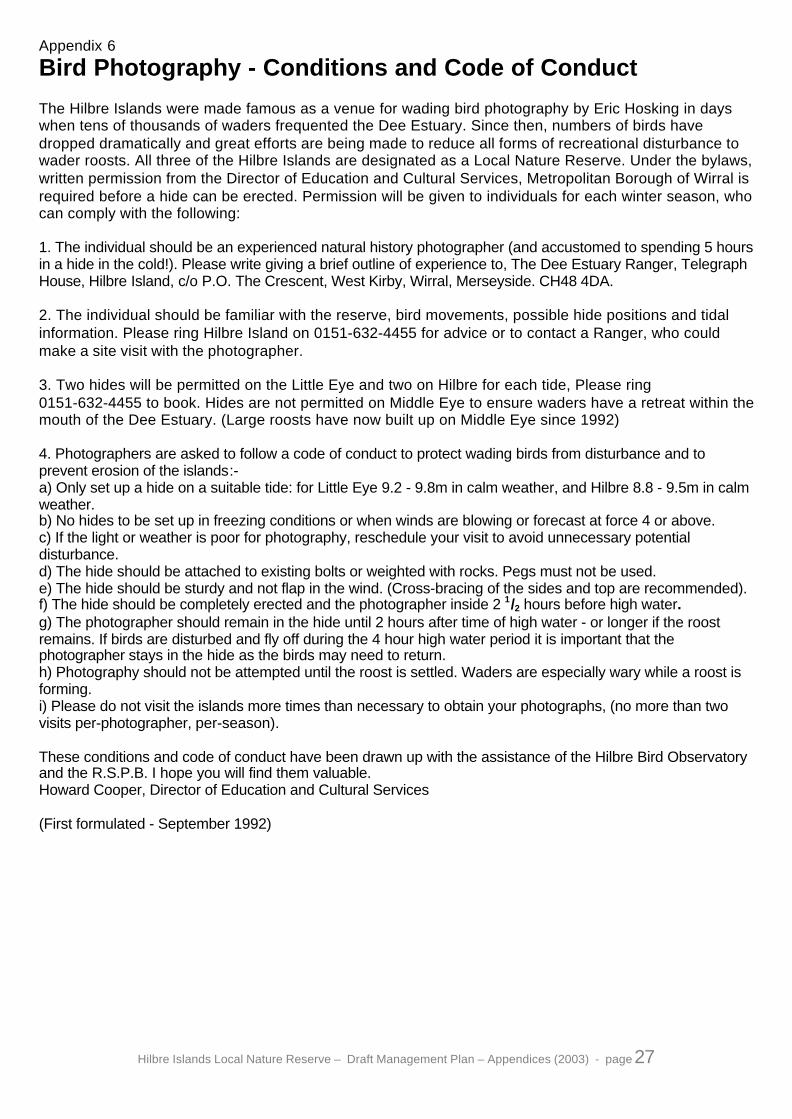
Bird Photography - Conditions and Code of Conduct
The Hilbre Islands were made famous as a venue for wading bird photography by Eric Hosking in dayswhen tens of thousands of waders frequented the Dee Estuary. Since then, numbers of birds havedropped dramatically and great efforts are being made to reduce all forms of recreational disturbance towader roosts. All three of the Hilbre Islands are designated as a Local Nature Reserve. Under the bylaws,written permission from the Director of Education and Cultural Services, Metropolitan Borough of Wirral isrequired before a hide can be erected. Permission will be given to individuals for each winter season, whocan comply with the following:
1. The individual should be an experienced natural history photographer (and accustomed to spending 5 hoursin a hide in the cold!). Please write giving a brief outline of experience to, The Dee Estuary Ranger, TelegraphHouse, Hilbre Island, c/o P.O. The Crescent, West Kirby, Wirral, Merseyside. CH48 4DA.
2. The individual should be familiar with the reserve, bird movements, possible hide positions and tidalinformation. Please ring Hilbre Island on 0151-632-4455 for advice or to contact a Ranger, who couldmake a site visit with the photographer.
3. Two hides will be permitted on the Little Eye and two on Hilbre for each tide, Please ring0151-632-4455 to book. Hides are not permitted on Middle Eye to ensure waders have a retreat within themouth of the Dee Estuary. (Large roosts have now built up on Middle Eye since 1992)
4. Photographers are asked to follow a code of conduct to protect wading birds from disturbance and toprevent erosion of the islands:-a) Only set up a hide on a suitable tide: for Little Eye 9.2 - 9.8m in calm weather, and Hilbre 8.8 - 9.5m in calmweather.b) No hides to be set up in freezing conditions or when winds are blowing or forecast at force 4 or above.c) If the light or weather is poor for photography, reschedule your visit to avoid unnecessary potentialdisturbance.d) The hide should be attached to existing bolts or weighted with rocks. Pegs must not be used.e) The hide should be sturdy and not flap in the wind. (Cross-bracing of the sides and top are recommended).f) The hide should be completely erected and the photographer inside 2 1/2 hours before high water.g) The photographer should remain in the hide until 2 hours after time of high water - or longer if the roostremains. If birds are disturbed and fly off during the 4 hour high water period it is important that thephotographer stays in the hide as the birds may need to return.h) Photography should not be attempted until the roost is settled. Waders are especially wary while a roost isforming.i) Please do not visit the islands more times than necessary to obtain your photographs, (no more than twovisits per-photographer, per-season).
These conditions and code of conduct have been drawn up with the assistance of the Hilbre Bird Observatoryand the R.S.P.B. I hope you will find them valuable.Howard Cooper, Director of Education and Cultural Services
(First formulated - September 1992)

Hilbre Islands Local Nature Reserve – Draft Management Plan – Appendices (2003) - page 28
Appendix 7
Guidance for School Visits
Visits by schools deliver the needs of Objective 4.2, promoting greater understanding of the value andimportance of the reserve. There are however many considerations to make in order to ensure a visit'spotential is realised. Project 4.2.13 calls for the production and circulation of a schools visit procedure;until this is drawn up, the following information will form the basis of the guidance given to schoolsplanning a visit.
• Educational group visits will be limited to a maximum of 30 pupils (rather than the normal limit of 50 forall Hilbre groups.)
• Visits by Infants (Years 1, 2 & 3) are inappropriate because of the Health and Safety Risksoutweighing the potential benefits.
• Schools will be met by the ranger on the main island, following their walk out from West Kirby.
• Visits will be targeted over low water, when there is more space to undergo activities, eg. pool dipping,cave exploration, beach games. Visits over high water are only appropriate for less active groups, egbirdwatching, and involve a stay away from the mainland of about 6 or 7 hours
• Activities involving the capture of live animals will be managed carefully to reduce the harm done tothe wildlife, to teach respect for the wildlife, and to promote observation and understanding of thehabitat and ecosystem. This will normally be achieved by keeping the group size to 15 or limiting thenumber of nets to 10, and limiting the time to 45 minutes. This allows more individual attention andhelps deliver the above targets.

Hilbre Islands Local Nature Reserve – Draft Management Plan – Appendices (2003) - page 29
Appendix 8
Bylaws
The Metropolitan Borough of Wirral in exercise of the powers conferred upon them by Sections 20, 21 (4)and 106 of the National Parks and Access to the Countryside Act, 1949, and in accordance with Section236 of the Local Government Act, 1972, hereby make the following Byelaws for the protection of theHilbre Islands Local Nature Reserve in Wirral in the County of Merseyside.
1. In these Byelaws "the Reserve" means the pieces or parcels of land containing in the whole 49 hectaresor thereabouts and situated in the Metropolitan Borough of Wirral declared to be managed as a NatureReserve by the Metropolitan Borough of Wirral on the 26th day of July 1983, in pursuance of Section 21 of theNational Parks and Access to the Countryside Act, 1949, and the Reserve is for the purpose of identificationshown as nearly as may be in the map annexed to these Byelaws and therein coloured pink.
2. Throughout these Byelaws the expression "the Council" means the Metropolitan Borough of Wirral.
3. "Firearm" shall have the same meaning as in Section 57 of the Firearms Act, 1968.
4. An act necessary to the proper execution of his duty in the Reserve by an officer of the Council or by anyperson or servant of any person employed or authorised by the Council shall not be deemed an offenceagainst these Byelaws.
5. No person shall be allowed access to the Reserve without a permit issued by the Director of LeisureServices and Tourism for the time being of the Council.
6. No person under the age of 16 shall be allowed access to the Reserve unless accompanied by a personaged 16 or over who has been issued with an appropriate permit.
7. Within the Reserve the following acts are hereby prohibited, except insofar as they may be authorised bythe written permission of the Director of Leisure Services and Tourism for the time being of the Council, orinsofar as they may be in accordance with Byelaw 4 above;
i) Taking, molesting or intentionally disturbing, injuring or killing any living creature;
ii) Taking or intentionally disturbing or destroying the eggs, larvae, pupae or other immature stages, or theplace used for the shelter or protection of any living creature;
iii) Spreading or using any net, or setting or using any lamp or other instrument, or any snare or lure, for thetaking, injury or destruction of any living creature;
iv) Intentionally removing any material from any area of the Reserve;
v) Intentionally removing, displacing, damaging or defacing any tree, shrub, plant, fungus or part thereof, orany unfashioned mineral including water;
vi) Intentionally bringing or permitting to be brought into the Reserve any living creature, or the egg of anyliving creature, or any plant, or any seed or any other part of any plant, in such circumstances that it is likelythat such creature or plant will reproduce or propagate itself, or such egg will hatch, or such seed willgerminate;
vii) Driving, riding, propelling or leaving any mechanically propelled vehicle (including hovercraft);
viii) Bringing into or permitting to remain any animal. Provided that this Byelaw shall not apply to any dogkept on a lead and under proper control and effectively restrained from injuring or disturbing any person,animal or bird or damaging or defacing any tree, shrub, plant, fungus or part thereof;
ix) Erecting, occupying or using any tent, shed, hide, van or other structure;

Hilbre Islands Local Nature Reserve – Draft Management Plan – Appendices (2003) - page 30
x) Lighting any fire, stove, heater, firework or other appliance capable of causing fire or discarding orthrowing any lighted match or lighted substance in a manner likely to cause a fire;
xi) Boating, bathing or wading in any water body other than the sea;
xii) Any act which pollutes or is likely to pollute any water;
xiii) Intentionally or recklessly removing or displacing any notice board, notice, fence, barrier, post,boardwalk, bridge, hide or other structure;
xiv) Being in possession of a firearm, catapult, bow and arrow or a crossbow;
xv) Discharging a firearm, catapult, bow and arrow or a cross bow;
xvi) Flying any model aircraft or sailing any model boat in any water body other than the sea;
xvii) The use of any apparatus for the transmission, reception, reproduction or amplification of sound, orimages by electrical or mechanical means, except apparatus designed and used to aid defective hearing, insuch a manner as to cause annoyance to or interfere with the quiet enjoyment of the Reserve by any othermembers of the public or to cause harm to any living creature or plant in the Reserve;
xiii) Intentionally obstructing any officer of the Council or any person or the servant of any person employedor authorised by the Council in the execution of any works, including research or scientific work connected withthe laying out, maintenance or management of the Reserve;
xix) Intentionally leaving items in a place other than a receptacle provided by the Council for deposit of litteror refuse;
xx) Entering at any time any part of the Reserve where notice to keep out has been posted by order of theCouncil;
xxi) Turning out any animal or poultry to feed or graze;
xxii) Landing any aircraft except in emergency;
xxiv) Using any device designed or adapted for detecting or locating any metal or mineral in the Reserve;
xxv) Riding any bicycle, tricycle or similar machine elsewhere than in a place indicated by a notice as beingavailable for the purpose.
8. i) The Director of Leisure Services and Tourism for the time being of the Council may give writtenpermission authorising any person or persons to do any act or class of acts (subject to general legislation inforce at the time of issue), within the Reserve or any part thereof which would otherwise be unlawful underthese Byelaws.
ii) Any such written permission shall be given subject to such conditions as may from time to time be laiddown by the Director of Leisure Services and Tourism for the time being of the Council and shall include thefollowing conditions:
a) that such written permission be carried whenever a visit is made to the Reserve by the person orpersons specified therein and produced for inspection when required by any officer of the Council, or by anyother duly authorised person, and
b) that it may be revoked by the Director of Leisure Services and Tourism for the time being of the Councilat any time.
9. Any person who offends against any of these Byelaws shall be liable upon summary conviction to a finenot exceeding level 2 on the standard scale, and in the case of a continuing offence to a further fine notexceeding £5. for each day during which the offence continues after conviction therefore.
Hilbre Islands Local Nature Reserve – Draft Management Plan – Appendices (2003) - page 31
10. Every person who shall infringe any Byelaw for the regulation of the Reserve may be removed therefromby any officer of the Council, or by any constable, in any one of the several cases hereinafter specified, that isto say:-
i) Where the infraction of the Byelaw is committed within the view of such officer or constable, and thename and residence of the person infringing the Byelaw are unknown to and cannot be readily ascertained bysuch officer or constable;
ii) Where the infraction of the Byelaw is committed within the view of such officer or constable and, from thenature of such infraction, or from any other fact of which such officer or constable may have knowledge, or ofwhich he may be credibly informed, there may be reasonable ground for belief that the continuance in theReserve of the person infringing the Byelaw may result in another infraction of a Byelaw, or that the removal ofsuch person from the Reserve is otherwise necessary as a security for the proper use and regulation thereof.
THE COMMON SEAL OF METROPOLITAN BOROUGH OF WIRRAL was hereunto affixed this 15th day ofDecember 1986 Seal No. 15937 in the presence of:
J T GoodacreAuthorised Officer
Please note that the Post of Director of Leisure Services and Tourism no longer exsists. The Head ofDepartment is now the Director of Education and Cultural Services.

Hilbre Islands Local Nature Reserve – Draft Management Plan – Appendices (2003) - page 32
Appendix 9
Engineers Report
ENGINEER’S REPORT ON HILBRE ISLAND EXISTING COASTAL WORKSAND EROSION OF THE N.W. SANDSTONE CLIFFS
1.0 Introduction
1.1 Officers of Leisure Services & Tourism requested an updated report on the coast protection issuesaffecting the islands.
1.2 This request follows concerns for the natural and man-made structures on the north west side of HilbreIsland.
2.0 Report Parameters
2.1 The survey area is limited to the area between the old lifeboat station and the steps below the navigationtower on the west side, a distance of approximately 270m.
2.2 The report is limited to the impact of erosion on natural and man-made structures. erosion mechanisms,wave impacts, condition of coastal structures and details related to these processes.
2.3 The general issues of the islands is not included.
3.0 Previous Reports
3.1 Various reports have been on the subject of coast protection and other issues relating to the islands.
3.2 Report on the island of Hilbre, dated Oct 1976 (42 page) by Brian Barnes (Director Leisure Services) toCouncil. Gives a very good general background and includes under item 5.3 engineering works to repair orreplace damaged blockwork.
3.3 Report on the Coast Protection structures by the Borough Engineer dated 14th December 1983.
3.4 Invitations to tender for works to repair masonry on the north west side of the island, several contractorssubmitted tenders in the range £7,000 - £9,490 -contract not issued.
3.5 Various letters and Hilbre Island management committee reports relate to the ongoing erosion problems.
4.0 General Outline
4.1 The islands lie approximately 1700m west of Red Rocks, Stanley Road on the north western tip ofWirral.
4.2 The area of the islands taken from a 2nd Sept 1999 aerial survey show the plateau area of each islandas:-Hilbre Island 40,975 m2 (10.125 acres)Middle Island 9,397 m2 ( 2.322 acres)Little Eye 180 m2 ( 0.0445 acres)
The total length of the chain, including the connecting ridges, submerged at high tide, is 2220m.
4.3 The visible footprint of Hilbre Island and Middle Island including the rocky littoral zone around andbetween these two islands equate to 281,000 m2 (69.44 acres) at 2nd Sept 1999.
4.4 The islands represent the most northerly tip of a ridge running south east and includes the offshoreoutcrops of Tansky rocks, Seldom Seen and Caldy Blacks The sandstone ridge continues into South Wirral,Burton Point being the next coastal exposure of sandstone

Hilbre Islands Local Nature Reserve – Draft Management Plan – Appendices (2003) - page 33
5.0 Geology
5.1 The geology has been included within this report, as the general geological make-up of the islands lendsitself to the erosion problems besetting the islands.
5.2 The geological drift map (No. 96. reprinted 1975) shows the islands to be formed from False bedded redand yellow bunter sandstones, with a 300mm thick bed of breccia (gravels, pebbles or angular stonescemented by lime etc).
5.3 The report of 1976 also states that “the sandstones dip eastwards at an average 100 , resulting in highercliffs on the western side and a larger rocky littoral zone to the east”.
5.4 This tilt exposes the breccia beds on the west side to erosion from hydraulic forces explained in section7. Furthermore, rainfall is induced to drain through the rock to the east giving rise to some erosion and clifffalls.
5.5 The sandstone is very soft and easily weathered, as witnessed on the day of the survey (section 8.0).The cliff to the right of the access ramp to Hilbre was showing recent signs of rock falls and the Rangerreported recent falls on Middle Hilbre.
6.0 History
6 1 There are numerous references to the size of Hilbre Islands in documents, charts and sailing directions.Most suggest that Hilbre was substantially larger. Some suggest that there was only one large island, othersstate that the islands were originally attached to Cheshire. It is certain, the islands have been eroding forpossibly 10,000 years.
6.2 Mersey Docks & Harbour Co took possession of the islands in 1856 as part of the telegraph link betweenHolyhead and Liverpool.
6.3 The large sandstone masonry to the north west side was constructed by MDHCo to protect the telegraphstation and navigational aids from the serious undercuts on this side of the island. There are also severalsmaller masonry supports to undercuts on the east side of Hilbre
6.4 There are several undated masonry pillar supports to the undercuts around the centre of Shell beach,although these are in poor condition due to further undermining.
6.5 Maintenance works are carried out by the Ranger Service, sometimes with volunteer assistance. This islimited to making good joints in the masonry or replacing small amounts of displaced blockwork.
6.6 During an earlier survey by the Engineers, a local potholer volunteered to enter breather hole No. 2 inthe masonry blockwork to survey the interior. He confirmed a small chamber with sound roof and walls with asmall amount of shells and sand on the floor. The others were all blind ports.
6.7 The islands passed to local authority control in 1945 (HUDC).
7.0 Erosion Mechanism
7.1 The maximum fetch available to the islands is from the north west, where there are117 nautical miles ofopen, uninterrupted water to Dundalk Bay in Southern Ireland. Therefore, the maximum wave height possiblein deep water will be “fetch limited”.
7.2 It is theoretically possible to have 10m high waves approaching the coast from the north west, but due toshallowing water and the reef seawards of the cliffs, a more realistic wave height of 3m impacting the cliffcould be expected in winter months.
7.3 The nature of Shell Beach conspires to worsen this scenario. Stones, shells and sand act as an abrasivewithin the waves.
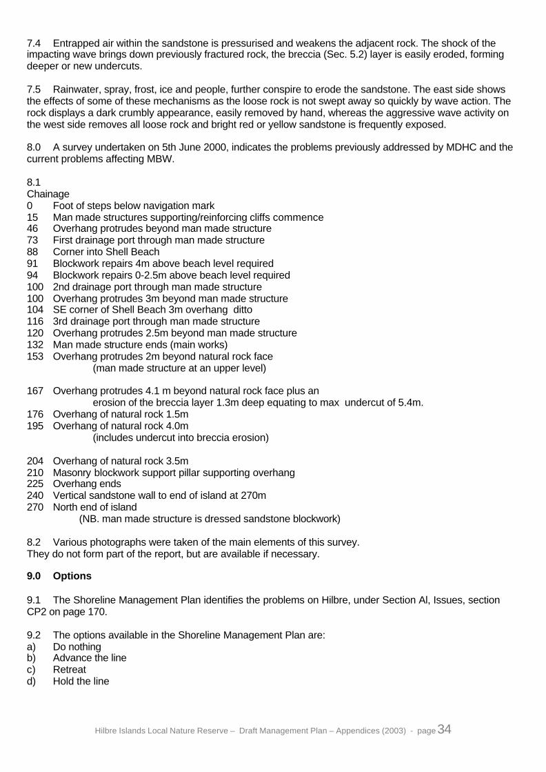
Hilbre Islands Local Nature Reserve – Draft Management Plan – Appendices (2003) - page 34
7.4 Entrapped air within the sandstone is pressurised and weakens the adjacent rock. The shock of theimpacting wave brings down previously fractured rock, the breccia (Sec. 5.2) layer is easily eroded, formingdeeper or new undercuts.
7.5 Rainwater, spray, frost, ice and people, further conspire to erode the sandstone. The east side showsthe effects of some of these mechanisms as the loose rock is not swept away so quickly by wave action. Therock displays a dark crumbly appearance, easily removed by hand, whereas the aggressive wave activity onthe west side removes all loose rock and bright red or yellow sandstone is frequently exposed.
8.0 A survey undertaken on 5th June 2000, indicates the problems previously addressed by MDHC and thecurrent problems affecting MBW.
8.1Chainage0 Foot of steps below navigation mark15 Man made structures supporting/reinforcing cliffs commence46 Overhang protrudes beyond man made structure73 First drainage port through man made structure88 Corner into Shell Beach91 Blockwork repairs 4m above beach level required94 Blockwork repairs 0-2.5m above beach level required100 2nd drainage port through man made structure100 Overhang protrudes 3m beyond man made structure104 SE corner of Shell Beach 3m overhang ditto116 3rd drainage port through man made structure120 Overhang protrudes 2.5m beyond man made structure132 Man made structure ends (main works)153 Overhang protrudes 2m beyond natural rock face
(man made structure at an upper level)
167 Overhang protrudes 4.1 m beyond natural rock face plus anerosion of the breccia layer 1.3m deep equating to max undercut of 5.4m.
176 Overhang of natural rock 1.5m195 Overhang of natural rock 4.0m
(includes undercut into breccia erosion)
204 Overhang of natural rock 3.5m210 Masonry blockwork support pillar supporting overhang225 Overhang ends240 Vertical sandstone wall to end of island at 270m270 North end of island (NB. man made structure is dressed sandstone blockwork)
8.2 Various photographs were taken of the main elements of this survey.They do not form part of the report, but are available if necessary.
9.0 Options
9.1 The Shoreline Management Plan identifies the problems on Hilbre, under Section Al, Issues, sectionCP2 on page 170.
9.2 The options available in the Shoreline Management Plan are:a) Do nothingb) Advance the linec) Retreatd) Hold the line

Hilbre Islands Local Nature Reserve – Draft Management Plan – Appendices (2003) - page 35
9.3 The accepted option for the area under consideration is Hold the line. However theother options are considered for economic and aesthetic reasons.
9.4 Do nothing
Accept that the cliff erosion will continue at an approximate rate of 100mm per annum. Further erosion androck falls will cut off the old lifeboat station, viewing hide and tide recording station. The timescale isdependent on wave activity and tide height. The island is approximately 20m wide at the north end and givensay 100mm P/A erosion on the west side coupled with say 50mm P/A on the east side, it will take theoretically133 years to completely fail. However as the sandstone dips 10 degrees to the east. The erosion will exposethe breccia at lower levels, which will then be exposed to a greater number of tides and hence exponentialfailure.
Increased tide depth will have a further impact, current MAFF guidelines are 4mm per annum increase ingeneral sea levels for NW England.
9.5 Hold the line/Advance the line -Rock Armour
Reinforce the section CH 132 to CH 270 with imported rock armour. This could be sourced from Arklow inSouthern Ireland and shipped to the north end of Shell Beach and side tipped for recovery at low water andplaced up-against the present undercuts to break up wave energy.
The main advantages are that:a) the basalt is less conspicuous than the limestone of North Walesb) delivery is easier than truck movements across the foreshore of West Kirbyc) Relatively cheap
9.6 Hold the line - Insitu concrete infill and support
Clear out all the undercuts by machine and high pressure water to remove marine growth, sands and silts.
Shutter faces and fill with concrete dyed with iron oxides to replicate a sandstone coloured finish.All materials and equipment would need to be imported via West Kirby with the resultant impact on safety,finances and the public.
9.7 Hold the line - Gunite (sprayed concrete)
Similar to 9.3 above, but there would be less local impact on access as vehicle movements would besubstantially less.
9.8 Hold the line - Existing blockwork and joint repairs
It is imperative that on-going repairs to blockwork joints is continued. The present ranger/volunteerarrangement is adequate if well funded. If the blockwork is allowed to deteriorate, the results will be beyondpresent measures.
9.9 None of these options address the issue of aesthetics. It is assumed that marine growth will recolonisethe concrete or rock armour protection and mask the protection. Access to Shell Beach would be necessary,unless plant and equipment could be craned down to the working area.
10.0 Funding
10.1 No estimates have been prepared for this report
10.2 A recent Ministry of Agriculture, Fisheries and Food letter, received 10th April 2000, ref - Flood Defenceand Coast Protection 2000-01 to 2003-04, Capital Expenditure profiles and summary documents, item 6states:-

Hilbre Islands Local Nature Reserve – Draft Management Plan – Appendices (2003) - page 36
‘The indicative threshold priority scores will apply to all authorities, with exceptional treatment afforded to: 6Bwhere necessary, to accommodate funding measures to protect internationally important wildlife sites. Theonly such local authority scheme identified so far is that at Walney Island, Cumbria and consideration ofexceptional treatment will be given when a relevant study has been undertaken.”
This may have possibilities, due to the islands being within the Dee Estuary and designated as a RAMSARsite, under the conversion for wetlands of international importance; also a special protection area (SPA) underEEC Directive on conservation of wild birds and the islands themselves, being a Local Nature Reserve (LNR).
11.0 Conclusion
11.1 A do nothing option will leave the islands to be remodelled until the assets of the tide recording station,north slipway (already damaged) and the bird observatory will be isolated and finally become untenable.
11.2 An issue directly related to a do nothing option, is the safety of the public using Shell Beach and otherareas with overhung arches. It would be a wise precaution to erect signage and warn the public of the risk ofrockfalls.
11.3 From a structural engineering viewpoint, option 9.5 would be the most effective and probably thecheapest, with on-going repairs as noted in section 9.8.
E A WILLIAMSJUNE 2000

Hilbre Islands Local Nature Reserve – Draft Management Plan – Appendices (2003) - page 37
Appendix 10
List of Contacts and Partners
Metropolitan Borough of Wirral:
Mr Jim Lester, Senior Inspector - Cultural Services, Metropolitan Borough of Wirral, Education andCultural Services, Hamilton Building, Conway Street, Birkenhead, Wirrral CH41 4FD
Mr Dave Cowling, Head of Parks and Open Spaces, Metropolitan Borough of Wirral, Education andCultural Services, Solar Campus, 235 Leasowe Road, Wallasey, Wirral CH45 8RE
Mr Martyn Jamieson, Head Ranger, Wirral Country Park Visitor Centre, Station Road, Thurstaston, WirralCH61 0HN
Mr Adam King, Senior Coastal Ranger, North Wirral Coastal Park, Leasowe Lighthouse, Pasture Road,Moreton, Wirral CH46 4TA
Mr Dave Cavanagh, Ranger, Telegraph House, Hilbre Island, c/o Post Office, The Crescent, West Kirby,Wirral CH48 4DA
Mr Tony Jones, Beach Lifeguard Service, Albion Street, New Brighton, Wirral
Mr Malcolm Alexander, Assistant Director, Drainage and Coastal Protection, Engineering and HighwayServices Department, Town Hall, Bebington, Wirral CH63 7PT
Caroline Reid, Local Agenda 21 Officer, Town Hall, Wallasey
Other Public Organisations:Dr Martin Bailey, Maritime Conservation Officer, English Nature, North West Region, Pier House, WiganPier, Wigan, Lancashire
Mr Bob Lloyd, Hydrographic Surveyor, Marine Operations, Mersey Docks and Harbour Company,Maritime Centre, Port of Liverpool, CH21 1LA
Dr Ian Wallace, Liverpool Museum, William Brown Street, Liverpool L3 8EN
Private Individuals and OrganisationsThe addresses of the following are not included here on the grounds of privacy
Mrs Barbara Greenwood, Cheshire Wildlife Trust (Wirral Members Group),
Mr Chris Mahon, Conservator - Cheshire Wildlife Trust
Ms Juliet Whiteley, Hilbre Tenants
Mr Colin Wells, Royal Society for the Protection of Birds
Mr Peter Williams, Hilbre Bird Observatory
Dr Karen Leeming, Dee Estuary Voluntary Wardens
Ms Susan Craggs, The Friends of Hilbre
Hilbre Islands Local Nature Reserve – Draft Management Plan – Appendices (2003) - page 38
Other Consultee Organisations
Environment Agency Wales,Northern Wales Area Office, Ffordd Penian, Bangor, Gwynedd LL57 4DE
Dee Estuary Strategy (currently dormant)
Dee Estuary Recreation Users Group (currently dormant)
Dee Estuary Conservation Group
North Western and North Wales Sea Fisheries Committee,University of Lancaster, Lancaster, Lancs LA1 4YY
Maritime and Coastguard Agency, Hall Road West, Crosby, Liverpool L23 8SY

Hilbre Islands Local Nature Reserve – Draft Management Plan – Appendices (2003) - page 39
Appendix 11
Projects
Project Code 1.2.1Project Title Encourage the spread of the maritime flora
(e.g. heather, scurvy grass, thrift, and sea plantain).Description Initially in a trial plot, then extend if successful.(Hilbre and Middle)Action by… HiRMethod Mow areas of long grass adjacent to existing maritime flora on Hilbre and Middle Eye.
TimetableJan Feb Mar Apr May Jun Jul Aug Sep Oct Nov Dec
20032004 Y2005 Y2006 Y2007 Y
Project Code 1.2.2Project Title Increase floristic diversity in the paddocks.Description Maintain sheep grazing or use mowing in the paddocks to reduce sward height.
Ensure level of grazing does not significantly reduce nesting bird populationsAction by… HiR & TOFMethod No Grazing or Mowing between 15th March and15th July.
Fence off small area to monitor effects of no grazing/mowing.Removal of cuttings due to mowing may be advisable.
TimetableJan Feb Mar Apr May Jun Jul Aug Sep Oct Nov Dec
2003 Y Y Y Y Y Y2004 Y Y Y Y Y Y Y Y Y2005 Y Y Y Y Y Y Y Y Y2006 Y Y Y Y Y Y Y Y Y2007 Y Y Y Y Y Y Y Y Y
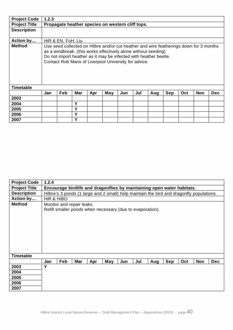
Hilbre Islands Local Nature Reserve – Draft Management Plan – Appendices (2003) - page 40
Project Code 1.2.3Project Title Propagate heather species on western cliff tops.Description
Action by… HiR & EN, FoH, LiuMethod Use seed collected on Hilbre and/or cut heather and wire featherings down for 3 months
as a windbreak. (this works effectively alone without seeding)Do not import heather as it may be infected with heather beetle.Contact Rob Maris of Liverpool University for advice.
TimetableJan Feb Mar Apr May Jun Jul Aug Sep Oct Nov Dec
20032004 Y2005 Y2006 Y2007 Y
Project Code 1.2.4Project Title Encourage birdlife and dragonflies by maintaining open water habitats.Description Hilbre’s 3 ponds (1 large and 2 small) help maintain the bird and dragonfly populations.Action by… HiR & HiBOMethod Monitor and repair leaks.
Refill smaller ponds when necessary (due to evaporation).
TimetableJan Feb Mar Apr May Jun Jul Aug Sep Oct Nov Dec
20032004200520062007
Y

Hilbre Islands Local Nature Reserve – Draft Management Plan – Appendices (2003) - page 41
Project Code 1.2.5Project Title Retain soil and vegetation along cliff-tops.Description The low cliff-top walls along the west side and north end of Hilbre need maintaining and
extending to help prevent loss of soil and vegetation through wave erosion.Of particular importance are the Rock Sea Lavender populations.
Action by… HiR & FoH, volsMethod Use small blocks of sandstone and mortar.
Trial an area using breeze block faced with sandstone
If the area looses bio-diversity, e.g. becomes dominated by coarse grasses, the areashould be allowed to flood with seawater in storm conditions, by removing a small sectionof wall, this will reduce the vigour of the coarse grass, and allow the specialised maritimeflora to flourish.
Study different methods/causes of erosion and use different methods of protectionaccordingly. i.e. to divert sea spray away from vegetation rather than directly support thesoil.
When constructing the low retaining walls, in order to reduce the amount of walling (foraesthetic reasons as well as to reduce the amount of material needed) corners should becut, even if small amounts of vegetation are left unprotected. In some cases the wall willbe built lower and in front of the vegetation, the space behind can then be infilled withground-up rock allowing the vegetation to re-establish.
TimetableJan Feb Mar Apr May Jun Jul Aug Sep Oct Nov Dec
20032004200520062007
Y

Hilbre Islands Local Nature Reserve – Draft Management Plan – Appendices (2003) - page 42
Project Code 1.3.1Project Title Maintain present shelter for the benefit of perching birds (passerines).Description Garden fences and the trees and shrubs they protect are important shelter for the
resident and visiting perching birds.Action by… HiR & HiBOMethod Repair and replace wood when necessary
The fence alongside the main track is subject to the most wind damage and needs theposts renewing, and buttresses added to existing posts.
TimetableJan Feb Mar Apr May Jun Jul Aug Sep Oct Nov Dec
2003 Y2004 Y2005 Y2006 Y2007 Y
Project Code 1.3.2Project Title Introduce artificial bird nesting sites.Description Nesting shelduck currently use the eastern cliff edge. Creating artificial nest sites could
increase breeding numbers.Action by… HiR & HiBO, ProudmanMethod Wooden nesting boxes with a viewing trapdoor to be placed on ground after removing
any turf, then covered in sand bags and soil and returfed.
TimetableJan Feb Mar Apr May Jun Jul Aug Sep Oct Nov Dec
2003 Y2004 Y2005 Y2006 Y2007 Y

Hilbre Islands Local Nature Reserve – Draft Management Plan – Appendices (2003) - page 43
Project Code 1.3.3Project Title Maintain field vole population.Description Maintain field vole populations in areas of long grass.Action by… HiR & MSMethod Manage grassland to include large areas of long grass in addition to the short grass
favoured by the maritime flora.
Identify areas where grass/vegetation is to be left to grow long as habitat for voles.
Shelters of sheet metal or preferably wood to be used to monitor the population.
Contact Mammal Society for further advice.
TimetableJan Feb Mar Apr May Jun Jul Aug Sep Oct Nov Dec
20032004200520062007
Y
Project Code 1.3.4Project Title Maintain atlantic grey seal population.Description Seals from the Dee Estuary Colony of Atlantic Grey Seals regularly visit Hilbre.Action by… SAR & HiR, EN, CCWMethod Agree a code of conduct with English Nature/CCW
Distribute annually the code of Conduct in Appendix 5 relating to the Seals
TimetableJan Feb Mar Apr May Jun Jul Aug Sep Oct Nov Dec
2003 Y2004 Y2005 Y2006 Y2007 Y
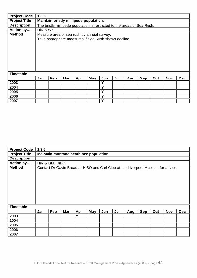
Hilbre Islands Local Nature Reserve – Draft Management Plan – Appendices (2003) - page 44
Project Code 1.3.5Project Title Maintain bristly millipede population.Description The bristly millipede population is restricted to the areas of Sea Rush.Action by… HiR & WpMethod Measure area of sea rush by annual survey.
Take appropriate measures if Sea Rush shows decline.
TimetableJan Feb Mar Apr May Jun Jul Aug Sep Oct Nov Dec
2003 Y2004 Y2005 Y2006 Y2007 Y
Project Code 1.3.6Project Title Maintain montane heath bee population.DescriptionAction by… HiR & LiM, HiBOMethod Contact Dr Gavin Broad at HiBO and Carl Clee at the Liverpool Museum for advice.
TimetableJan Feb Mar Apr May Jun Jul Aug Sep Oct Nov Dec
2003 Y2004200520062007

Hilbre Islands Local Nature Reserve – Draft Management Plan – Appendices (2003) - page 45
Project Code 1.4.1Project Title Maintain maritime heath and grassland communities by control of bracken.Description Remove the bracken on Hilbre, except for the south-east corner of the main island and
most of the east side of Middle Eye, where it acts as a nurse species for the bluebellsand a linnet nesting area.Priority to be given to the west side of Middle Eye and the old Gazebo garden.
Action by… HiR & FoH, volsMethod Bracken to be pulled where possible.
Dense rhizomes to be raked and removed.Where not possible to pull, break tops of young bracken with log dragged by two ropes.As a very last resort, weed-wiping with herbicide to be done by licensed ranger only.Special care taken to avoid ground water transportation to the sea spleenwort population,No spraying by herbicide to be done.Leave most of the bracken east of the path on Middle Eye as a nurse species for thebluebells but reduce the area by 25-50%.
TimetableJan Feb Mar Apr May Jun Jul Aug Sep Oct Nov Dec
2003 Y Y Y Y2004 Y Y Y Y2005 Y Y Y Y2006 Y Y Y Y2007 Y Y Y Y
Project Code 1.4.2Project Title Control of invasive plant species.Description Removal of the following invasive species from all areas except the fenced off gardens &
along the Eastern clifftop adjacent to gardens:-Duke of Argyle’s tea plantAlexanders
Removal of Ragwort from grazed areas
Action by… HiR & volsMethod Duke of Argyle’s tea plant by pulling and or weed-wiping with herbicide.
Alexanders by digging up in March and or weed-wiping with herbicide.Removal of ragwort spp. by pulling in June (advice needed because of possibledetrimental effect on Cinnabar Moth Population). Precautions against poisoning from theRagwort are needed, waterproof gloves essential
TimetableJan Feb Mar Apr May Jun Jul Aug Sep Oct Nov Dec
2003 Y Y2004 Y Y2005 Y Y2006 Y Y2007 Y Y

Hilbre Islands Local Nature Reserve – Draft Management Plan – Appendices (2003) - page 46
Project Code 1.4.3Project Title Control of Invasive shrubs.Description Removal of blackthorn except in the vicinity of the lower funnel traps where it provides
shelter for perching birds.Action by… HiR & volsMethod Stumps to be dug out
The possibility of stumps being treated with Garlon-4 is ruled out because of thepossibility of the herbicide being translocated to the blackthorn thicket in the Lower BirdTrap.
TimetableJan Feb Mar Apr May Jun Jul Aug Sep Oct Nov Dec
2003 Y Y2004 Y Y2005 Y Y2006 Y Y2007 Y Y
Project Code 1.4.4Project Title Removal of Pest Mammal Species.Description Rats are a significant Pest Mammal. It can have a devastating effect on nesting bird
populations. Other species are only occasionally a nuisance.Action by… HiR & WBC-PCMethod Baited traps or concealed poison boxes. Concealed poison boxes to be used only for rats
and mice. Baited traps to be used for foxes, rabbits and squirrels.
TimetableJan Feb Mar Apr May Jun Jul Aug Sep Oct Nov Dec
2003 Y Y Y Y Y2004 Y Y Y Y Y2005 Y Y Y Y Y2006 Y Y Y Y Y2007 Y Y Y Y Y

Hilbre Islands Local Nature Reserve – Draft Management Plan – Appendices (2003) - page 47
Project Code 1.5.1Project Title Compile a list of Research Needs.Description A list of research needs can be given to potential researchers, by circulating to
universities and colleges.Action by… HiR & SAR, HiMAG, ENMethod Projects should only be authorised on condition that a copy of the results will be sent to
Wirral Council on completion of the project.Projects that are likely to be damaging to the reserve should not be authorised;contact English Nature if in any doubt.Funding to be applied for, in order to attract a greater number of potential researchers,including those with higher qualifications and experience.
TimetableJan Feb Mar Apr May Jun Jul Aug Sep Oct Nov Dec
2003 Y2004 Y2005 Y2006 Y2007 Y
Project Code 1.5.2Project Title Carry out a National Vegetation Classification survey.Description A National Vegetation Survey (NVC) is the recognised standard for mapping of plant
communities.Action by… HiR & ENMethod This must be carried out by a trained NVC surveyor, therefor funding is required.
TimetableJan Feb Mar Apr May Jun Jul Aug Sep Oct Nov Dec
20032004 Y200520062007
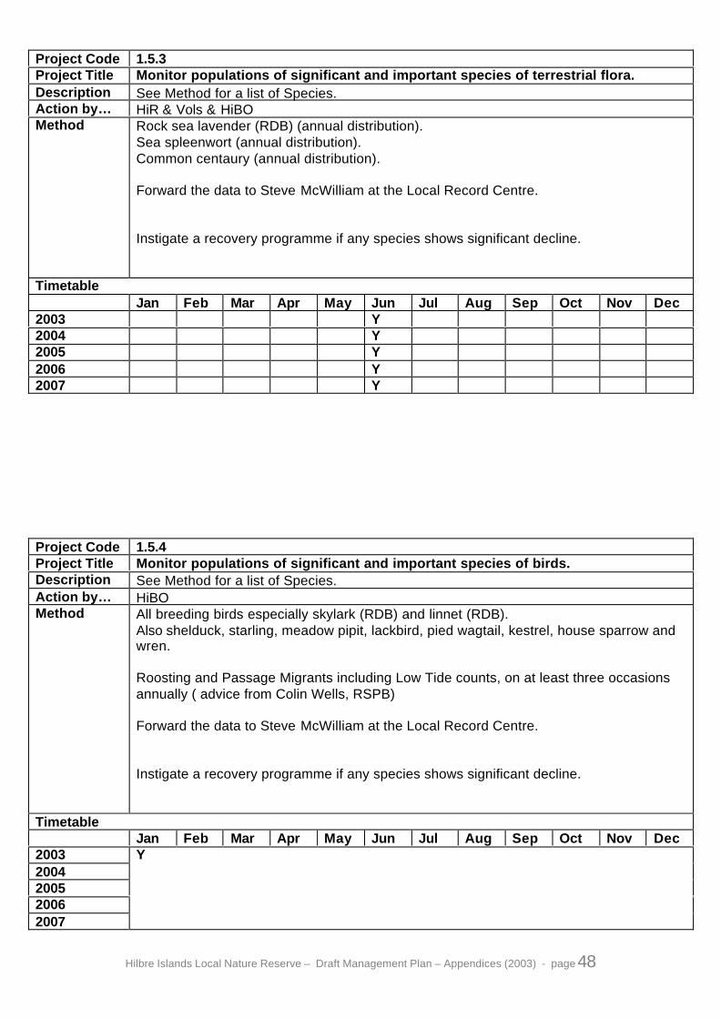
Hilbre Islands Local Nature Reserve – Draft Management Plan – Appendices (2003) - page 48
Project Code 1.5.3Project Title Monitor populations of significant and important species of terrestrial flora.Description See Method for a list of Species.Action by… HiR & Vols & HiBOMethod Rock sea lavender (RDB) (annual distribution).
Sea spleenwort (annual distribution).Common centaury (annual distribution).
Forward the data to Steve McWilliam at the Local Record Centre.
Instigate a recovery programme if any species shows significant decline.
TimetableJan Feb Mar Apr May Jun Jul Aug Sep Oct Nov Dec
2003 Y2004 Y2005 Y2006 Y2007 Y
Project Code 1.5.4Project Title Monitor populations of significant and important species of birds.Description See Method for a list of Species.Action by… HiBOMethod All breeding birds especially skylark (RDB) and linnet (RDB).
Also shelduck, starling, meadow pipit, lackbird, pied wagtail, kestrel, house sparrow andwren.
Roosting and Passage Migrants including Low Tide counts, on at least three occasionsannually ( advice from Colin Wells, RSPB)
Forward the data to Steve McWilliam at the Local Record Centre.
Instigate a recovery programme if any species shows significant decline.
TimetableJan Feb Mar Apr May Jun Jul Aug Sep Oct Nov Dec
20032004200520062007
Y

Hilbre Islands Local Nature Reserve – Draft Management Plan – Appendices (2003) - page 49
Project Code 1.5.5Project Title Monitor populations of significant and important species of Mammals.Description See Method for a list of Species.Action by… HiBO & HiRMethod Atlantic Grey Seals (weekly counts).
Field Vole.
Forward the data to Steve McWilliam at the Local Record Centre.
Instigate a recovery programme if any species shows significant decline.
TimetableJan Feb Mar Apr May Jun Jul Aug Sep Oct Nov Dec
20032004200520062007
Y
Project Code 1.5.6Project Title Monitor populations of significant and important species of terrestrial
invertebrates.Description See Method for a list of Species.Action by… HiBO & HiR, FoH, vols, WpMethod Butterflies by weekly transect and casual observation. In consultation with Butterfly
Conservation, and Dr Roger Dennis of Manchester Museum.
Forward the data to Steve McWilliam at the Local Record Centre.
Instigate a recovery programme if any species shows significant decline
TimetableJan Feb Mar Apr May Jun Jul Aug Sep Oct Nov Dec
2003 Y Y Y Y Y Y2004 Y Y Y Y Y Y2005 Y Y Y Y Y Y2006 Y Y Y Y Y Y2007 Y Y Y Y Y Y

Hilbre Islands Local Nature Reserve – Draft Management Plan – Appendices (2003) - page 50
Project Code 1.5.7Project Title Monitor populations of other significant and important species of the Marine and
Littoral community.DescriptionAction by… HiR & HiBO, FoH, volsMethod The priority species is the honeycomb reef forming worm, Sabellaria alveolata.
It will be useful to monitor sediment levels around the islands in conjunction with anystudy of the littoral community.
Forward the data to Steve McWilliam at the Local Record Centre.
Instigate a recovery programme if any species shows significant decline.
TimetableJan Feb Mar Apr May Jun Jul Aug Sep Oct Nov Dec
20032004200520062007
Y
Project Code 1.5.8Project Title Monitor populations of other significant and important species identified within the
Wirral Biodiversity Action Plan.DescriptionAction by… HiR & HiBO, FoH, volsMethod Instigate a recovery programme if any species shows significant decline.
See Wirral Biodiversity Plan for list of additional Projects.
TimetableJan Feb Mar Apr May Jun Jul Aug Sep Oct Nov Dec
20032004200520062007
Y

Hilbre Islands Local Nature Reserve – Draft Management Plan – Appendices (2003) - page 51
Project Code 2.1.1Project Title To keep the use of Hilbre as a Nature Reserve.Description To prevent any development that would damage its value as a nature reserve.Action by… WBC-PDMethod Through the planning process
TimetableJan Feb Mar Apr May Jun Jul Aug Sep Oct Nov Dec
20032004200520062007
Y
Project Code 2.2.1Project Title Draw up a programme of planned preventative maintenance for all buildings under
Council management.Description This project compliments a number of other projects, which also seek to keep the
buildings maintained.
Action by… HiR & WBC-BMMethod Whenever possible the repairs should be sympathetic to the character of the buildings,
and use contractors that have a proven track record in historic buildings, and anunderstanding of the scale of work appropriate on Hilbre.
TimetableJan Feb Mar Apr May Jun Jul Aug Sep Oct Nov Dec
20032004200520062007
Y

Hilbre Islands Local Nature Reserve – Draft Management Plan – Appendices (2003) - page 52
Project Code 2.2.2Project Title Record and designate, all the structures of historic and archaeological interest.Description The structures of historic and archaeological interest on Hilbre are: the Lifeboat station,
Telegraph House, Buoy-masters buildings, well, salt-works, pool and sluice gate.Action by… HiR & WBC-CO, FoHMethod Map and Photograph.
Apply for designation.
TimetableJan Feb Mar Apr May Jun Jul Aug Sep Oct Nov Dec
2003 Y2004 Y2005 Y2006 Y2007 Y
Project Code 2.2.3Project Title Maintain exterior masonry of the Telegraph House group of buildings.DescriptionAction by… HiR & vols, contractorMethod Use Scutch hammers to remove loose surface of paint and spalling masonry.
Repaint white.If funding available use contractors.
TimetableJan Feb Mar Apr May Jun Jul Aug Sep Oct Nov Dec
2003 Y Y Y Y2004 Y Y Y Y2005 Y Y Y Y2006 Y Y Y Y2007 Y Y Y Y

Hilbre Islands Local Nature Reserve – Draft Management Plan – Appendices (2003) - page 53
Project Code 2.2.4Project Title Restore Telegraph Station Lookout.Description This will include the repair of the wind-vane, windowsill and external steps.Action by… HiR & FoH, HiBOMethod Wind-vane is being repaired by HiBO.
External steps are being repaired by HiR &/or contractor.Building being repaired & repainted internally & externally by FoH.
TimetableJan Feb Mar Apr May Jun Jul Aug Sep Oct Nov Dec
2003 Y Y Y Y Y Y2004 Y2005 Y2006 Y2007 Y
Project Code 2.2.5Project Title Replace Buoymasters Workshop door lintel.DescriptionAction by… HiR & contractorMethod Funding required
TimetableJan Feb Mar Apr May Jun Jul Aug Sep Oct Nov Dec
20032004200520062007

Hilbre Islands Local Nature Reserve – Draft Management Plan – Appendices (2003) - page 54
Project Code 2.3.1Project Title Review bungalow leases.DescriptionAction by… HsCMethod Review bungalow leases every 10 years, and renew where they can be shown to have a
positive benefit to the reserve.
TimetableJan Feb Mar Apr May Jun Jul Aug Sep Oct Nov Dec
2003 Y2004 Y2005 Y2006 Y2007 Y
Project Code 2.3.2Project Title To maintain use of the Telegraph House group of buildings as the Rangers
domestic residence, office and workshop.DescriptionAction by… WBCMethod The occupation of Telegraph House is a condition of the post of Hilbre Ranger.
TimetableJan Feb Mar Apr May Jun Jul Aug Sep Oct Nov Dec
20032004200520062007
Y
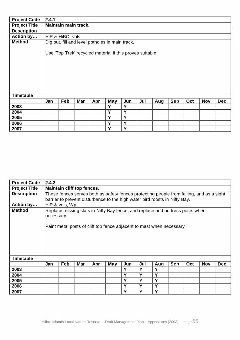
Hilbre Islands Local Nature Reserve – Draft Management Plan – Appendices (2003) - page 55
Project Code 2.4.1Project Title Maintain main track.DescriptionAction by… HiR & HiBO, volsMethod Dig out, fill and level potholes in main track.
Use 'Top Trek' recycled material if this proves suitable
TimetableJan Feb Mar Apr May Jun Jul Aug Sep Oct Nov Dec
2003 Y Y2004 Y Y2005 Y Y2006 Y Y2007 Y Y
Project Code 2.4.2Project Title Maintain cliff top fences.Description These fences serves both as safety fences protecting people from falling, and as a sight
barrier to prevent disturbance to the high water bird roosts in Niffy Bay.Action by… HiR & vols, WpMethod Replace missing slats in Niffy Bay fence; and replace and buttress posts when
necessary.
Paint metal posts of cliff top fence adjacent to mast when necessary
TimetableJan Feb Mar Apr May Jun Jul Aug Sep Oct Nov Dec
2003 Y Y Y2004 Y Y Y2005 Y Y Y2006 Y Y Y2007 Y Y Y

Hilbre Islands Local Nature Reserve – Draft Management Plan – Appendices (2003) - page 56
Project Code 2.4.3Project Title Replace bench seats in picnic area.DescriptionAction by… HiR & SDMethod Replacement seats must be substantial and anchored to prevent vandalism.
TimetableJan Feb Mar Apr May Jun Jul Aug Sep Oct Nov Dec
20032004 Y200520062007
Project Code 2.4.4Project Title Maintain gates and field boundary fences.DescriptionAction by… HiR & volsMethod Repair or replace if beyond repair.
TimetableJan Feb Mar Apr May Jun Jul Aug Sep Oct Nov Dec
20032004200520062007
Y

Hilbre Islands Local Nature Reserve – Draft Management Plan – Appendices (2003) - page 57
Project Code 2.4.5Project Title Repair, re-point and where appropriate repaint field boundary walls.DescriptionAction by… HiR & FoH, volsMethod Contact Vicky Morgan (nee Seager) for information on wall dwelling spiders.
Use wire brushes to remove loose paint.
TimetableJan Feb Mar Apr May Jun Jul Aug Sep Oct Nov Dec
20032004200520062007
Y
Project Code 2.5.1Project Title Renovate the 'Gazebo' site.DescriptionAction by… HiR & SAR, CT, HiBOMethod Remove left over building debris.
TimetableJan Feb Mar Apr May Jun Jul Aug Sep Oct Nov Dec
2003 Y Y Y2004 Y Y Y200520062007

Hilbre Islands Local Nature Reserve – Draft Management Plan – Appendices (2003) - page 58
Project Code 2.6.1Project Title Maintain existing sea walls.Description Major repairs e.g. underpinning are covered in project 2.6.2.Action by… Contractors & VolsMethod Repair and re-point existing sea walls in keeping with their historic character.
Small scale repairs can be done by volunteers.Major re-pointing and replacement of lost stonework to be done by contractors.
Funding needed.
TimetableJan Feb Mar Apr May Jun Jul Aug Sep Oct Nov Dec
20032004200520062007
Y
Project Code 2.6.2Project Title Investigate options regarding underpinning of sea walls.DescriptionAction by… Borough Engineers, EN, contractorsMethod It has been agreed that materials other than sandstone can be used below the MHWM
because it will soon be disguised with algal and barnacle growth.Funding needed.The loss of Marine Habitat especially Sabellaria reefs is an issue that needs to beresolved before plans can be finalised.
TimetableJan Feb Mar Apr May Jun Jul Aug Sep Oct Nov Dec
20032004200520062007
Y

Hilbre Islands Local Nature Reserve – Draft Management Plan – Appendices (2003) - page 59
Project Code 2.6.3Project Title Monitor all 3 islands by annual fixed-point photography.DescriptionAction by… HiR & WpMethod See file in Hilbre Office for locations.
TimetableJan Feb Mar Apr May Jun Jul Aug Sep Oct Nov Dec
2003 Y2004 Y2005 Y2006 Y2007 Y
Project Code 3.1.1Project Title Compile a list of suppliers who can provide an environmental audit of their goods
that demonstrates they have a low environmental impact.Description In order to purchase goods with the least environmental impact.Action by… HiR & LA21, Po-C&DMethod Use local and re-cycled resources wherever practicable.
Update list on an annual basis.
TimetableJan Feb Mar Apr May Jun Jul Aug Sep Oct Nov Dec
20032004 Y2005 Y2006 Y2007 Y

Hilbre Islands Local Nature Reserve – Draft Management Plan – Appendices (2003) - page 60
Project Code 3.2.1Project Title Minimise tipping, sewage, air & noise pollution.DescriptionAction by… HiR & Po-C&DMethod Recycle as much of the materials brought onto Hilbre as practicable.
Ensure present septic tank is dipped regularly and emptied in good time.Investigate feasibility of a composting toilet or septic tank for public use. (seeproject 4.1.4.)Minimising use of the diesel generator. (see project 3.2.3)
TimetableJan Feb Mar Apr May Jun Jul Aug Sep Oct Nov Dec
20032004200520062007
Y
Project Code 3.2.2Project Title Reduce impact of riverbourne & marine pollution.Description Expand information network & skills training that deal with these external pollution
sources.Action by… HiR & EA,MCA,CCW,EN,MCS,NWNWFFCMethod Keep close working relationship with above partners.
Inform through this network, of any actual or potential pollution threats.Maintain database on how to deal with various forms of pollution.
TimetableJan Feb Mar Apr May Jun Jul Aug Sep Oct Nov Dec
20032004200520062007
Y

Hilbre Islands Local Nature Reserve – Draft Management Plan – Appendices (2003) - page 61
Project Code 3.2.3Project Title Provide power from renewable resources for Council owned buildings.Description Investigate feasibility of installing a wind turbine and solar panels to power Telegraph
House, proposed Study Centre and Information Centre. Install if feasible.Action by… HiR & SAR, HdR, LA21, P, RSPB, HiBO, Proven, BWEAMethod Research feasibility of placing a turbine and solar power on Hilbre.
Options include: - large (<3Kw) turbine.- small (<1Kw) turbine.- solar panels to link into system.
Gain quotes for both material & fitting taking into account after sales care.Acquire planning permission.Source funding.
TimetableJan Feb Mar Apr May Jun Jul Aug Sep Oct Nov Dec
2003 Y2004200520062007
Project Code 3.3.1Project Title Minimise use of motor vehicles.Description Keep to a minimum the number of journeys to & from Hilbre.Action by… HiR & WBCMethod Authorise only those journeys necessary on the grounds of safety or management of the
reserve.The barrier at Dee Lane slipway can be locked shut to prevent vehicular access to thebeach. Authorised vehicles will be issued with keys.
TimetableJan Feb Mar Apr May Jun Jul Aug Sep Oct Nov Dec
20032004200520062007
Y

Hilbre Islands Local Nature Reserve – Draft Management Plan – Appendices (2003) - page 62
Project Code 3.4.1Project Title Encourage people to take litter home.DescriptionAction by… HiRMethod Include in written information, both in handouts and on noticeboards, that there is no
litterbin and people should to take their litter home.
TimetableJan Feb Mar Apr May Jun Jul Aug Sep Oct Nov Dec
20032004200520062007
Y
Project Code 3.4.2Project Title Remove litter regularly.Description Monitor the reserve for litter and remove.Action by… HiRMethod Litter sweep all three islands (at least weekly in summer in high use areas).
Bag all litter and remove it to the mainland.Volunteer groups are useful as they can cover a large area.
TimetableJan Feb Mar Apr May Jun Jul Aug Sep Oct Nov Dec
20032004200520062007
Y

Hilbre Islands Local Nature Reserve – Draft Management Plan – Appendices (2003) - page 63
Project Code 3.4.3Project Title Complete & implement an environmental audit.Description Audit waste, recycling, and energy use and identify practical measures to reduce
environmental impact.Action by… HiR & LA21, Po-C&DMethod Monitor annually.
TimetableJan Feb Mar Apr May Jun Jul Aug Sep Oct Nov Dec
2003 Y2004 Y2005 Y2006 Y2007 Y
Project Code 4.1.1Project Title Operate a visitor permit scheme.DescriptionAction by… HiR & WCPMethod See appendix 4.
TimetableJan Feb Mar Apr May Jun Jul Aug Sep Oct Nov Dec
20032004200520062007
Y
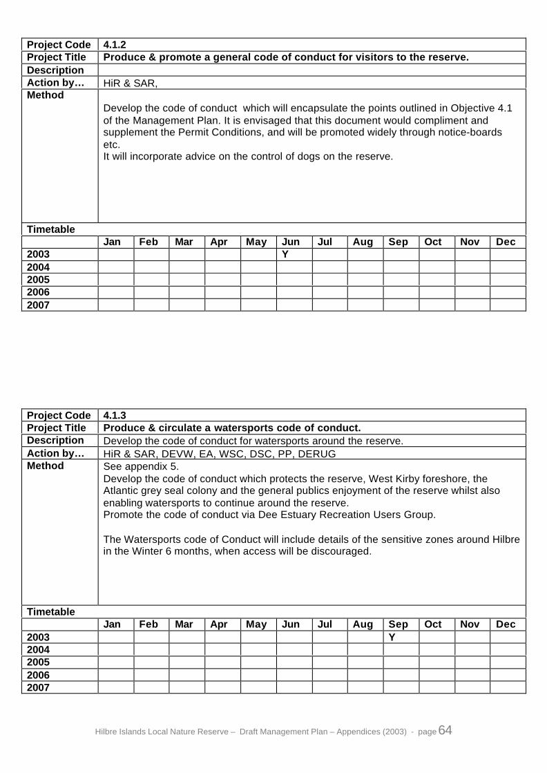
Hilbre Islands Local Nature Reserve – Draft Management Plan – Appendices (2003) - page 64
Project Code 4.1.2Project Title Produce & promote a general code of conduct for visitors to the reserve.DescriptionAction by… HiR & SAR,Method
Develop the code of conduct which will encapsulate the points outlined in Objective 4.1of the Management Plan. It is envisaged that this document would compliment andsupplement the Permit Conditions, and will be promoted widely through notice-boardsetc.It will incorporate advice on the control of dogs on the reserve.
TimetableJan Feb Mar Apr May Jun Jul Aug Sep Oct Nov Dec
2003 Y2004200520062007
Project Code 4.1.3Project Title Produce & circulate a watersports code of conduct.Description Develop the code of conduct for watersports around the reserve.Action by… HiR & SAR, DEVW, EA, WSC, DSC, PP, DERUGMethod See appendix 5.
Develop the code of conduct which protects the reserve, West Kirby foreshore, theAtlantic grey seal colony and the general publics enjoyment of the reserve whilst alsoenabling watersports to continue around the reserve.Promote the code of conduct via Dee Estuary Recreation Users Group.
The Watersports code of Conduct will include details of the sensitive zones around Hilbrein the Winter 6 months, when access will be discouraged.
TimetableJan Feb Mar Apr May Jun Jul Aug Sep Oct Nov Dec
2003 Y2004200520062007

Hilbre Islands Local Nature Reserve – Draft Management Plan – Appendices (2003) - page 65
Project Code 4.1.4Project Title Improve toilet facilities.Description Improve general toilet facilities and improve toilet access for those with special mobility
needs where practicable.Action by… SAR & HiR, Po-C&DMethod Two options are currently being evaluated:
- Build a composting toilet and improve access to the presentchemical toilet.
- Partition off part of the Goat shed and install chemical toilet forbunkhouse use only.
TimetableJan Feb Mar Apr May Jun Jul Aug Sep Oct Nov Dec
2003 Y Y Y Y2004200520062007
Project Code 4.1.5Project Title Disperse Erosion and Trampling Pressure.Description Maintain main paths and picnic area by mowing and re-seeding.Action by… HiRMethod Mow main paths on Hilbre and Middle Eye to a maximum width of 3 metres, (tapering
down to 1 metre where necessary) and re-seed with grass on eroded areas (PerennialRye Grass from native provenance can be used as it can withstand greater trampling).Where the path is by necessity narrow, and trampling pressure is too high to retain ryegrass, surface with shells.Mow also, the main picnic area.Diversions to be signposted with wooded hurdles and roped off where needed.
TimetableJan Feb Mar Apr May Jun Jul Aug Sep Oct Nov Dec
2003 Y Y Y Y Y Y Y2004 Y Y Y Y Y Y Y2005 Y Y Y Y Y Y Y2006 Y Y Y Y Y Y Y2007 Y Y Y Y Y Y Y

Hilbre Islands Local Nature Reserve – Draft Management Plan – Appendices (2003) - page 66
Project Code 4.2.1Project Title Maintain a Ranger resident on Hilbre Island.Description The primary duty of the Ranger will be contact with visitors in order to deliver the aims of
the Management PlanAction by… WBCMethod Funding currently from Wirral Council.
TimetableJan Feb Mar Apr May Jun Jul Aug Sep Oct Nov Dec
20032004200520062007
Y
Project Code 4.2.2Project Title Update & circulate the low-cost information & interpretative leaflet.Description This leaflet has information on how to get there, safety and history.Action by… HiR & SAR, WCP, WSC, TiCMethod Review & revise leaflet to ensure information is correct and up to date.
Maintain supply of leaflets at Visitor Centres, Wirral Sailing Centre and TiC's.Ensure the leaflet is displayed in the noticeboard at Dee Lane.Fit a self-service leaflet dispenser near the notice board at Dee Lane.This leaflet currently sells for 20 pence.A version printed on thicker paper will be needed for the leaflet dispenser at West Kirby inorder to prevent jamming in the damp conditions.
TimetableJan Feb Mar Apr May Jun Jul Aug Sep Oct Nov Dec
20032004200520062007
Y

Hilbre Islands Local Nature Reserve – Draft Management Plan – Appendices (2003) - page 67
Project Code 4.2.3Project Title Produce a low cost wildlife leaflet.Description This leaflet has information on how to get there, safety and wildlife.Action by… HiR & SAR, WCP, WSC, TiCMethod Research and design leaflet.
Source funding.Produce leaflet.Review & revise leaflet to ensure information is correct and up to date.Maintain supply of leaflets at Visitor Centres, Wirral Sailing Centre and TiC's.Ensure the leaflet is displayed in the noticeboard at Dee Lane.
TimetableJan Feb Mar Apr May Jun Jul Aug Sep Oct Nov Dec
20032004 Y200520062007
Project Code 4.2.4Project Title Produce an interpretative booklet.Description The booklet will be more detailed than the low cost leaflet.Action by… HdR & HiR, LHGMethod Work with various 'expert' groups.
The booklet will include sections on History, Natural History, Geography & Geology.
TimetableJan Feb Mar Apr May Jun Jul Aug Sep Oct Nov Dec
20032004 Y200520062007

Hilbre Islands Local Nature Reserve – Draft Management Plan – Appendices (2003) - page 68
Project Code 4.2.5Project Title Maintain a file of more in depth information enabling prompt response to
specialised enquiries.DescriptionAction by… HiR & SAR, FoH, HiBOMethod Transcribe important documents to electronic format.
Update web-site with downloadable files of specialised information where appropriate.Transcribe HiBO annual report statistics, with their permission.Collate press cuttings and news reports.Students carrying out academic work on the reserve will be asked for a copy of their finalreport.A species list for the reserve should be kept available and updated reularly.
TimetableJan Feb Mar Apr May Jun Jul Aug Sep Oct Nov Dec
20032004200520062007
Y
Project Code 4.2.6Project Title Produce a geology information sheet.Description A low cost Geology information sheet to compliment the low cost history and wildlife
leaflet.Action by… HiR & SARMethod Produce a double-sided A4 document.
The leaflet will Highlight Hilbre's status as a R.I.G.S. (Regionally Important Geologicaland Geomorphologic Site.)
TimetableJan Feb Mar Apr May Jun Jul Aug Sep Oct Nov Dec
20032004 Y200520062007

Hilbre Islands Local Nature Reserve – Draft Management Plan – Appendices (2003) - page 69
Project Code 4.2.7Project Title Increase awareness of Hilbre as an educational resource for schools.Description Produce schools packs.Action by… HiR & SAR, WCPMethod Produce 2 school packs for:
- primary schools,- secondary schools and further education establishments.
Draft to be completed by April 2004, to be finalised for circulation by September 2004.Primary Schools pack will include advice that visits by infants are inappropriate becausethe health and safety risks outweigh the potential benefits.Pack will contain information relevant for a visit to the island as well as resources for pre-visit & follow up work.Supply to all schools and colleges throughout Wirral.
TimetableJan Feb Mar Apr May Jun Jul Aug Sep Oct Nov Dec
20032004 Y Y200520062007
Project Code 4.2.8Project Title Provide information accessable via the web.Description Hilbre is the subject of many web sites, a high quality council managed website on Hilbre
will enable the official message to be widely seen.Action by… SAR & HiRMethod The site should include :
-safety and how to get there information-webcam pictures-history and natural history information-links to other sites such as Proudman Oceanographic Laboritories
TimetableJan Feb Mar Apr May Jun Jul Aug Sep Oct Nov Dec
20032004200520062007
Y

Hilbre Islands Local Nature Reserve – Draft Management Plan – Appendices (2003) - page 70
Project Code 4.2.9Project Title Promote the creation of the visitor Information Centre at West Kirby Beach.Description Visitors need to get information on safety, wildlife etc. before visiting the island. This is
best achieved by providing an information point at West Kirby Beach.
Until this centre is operational, Wirral Country Park Visitor Centre at Thurstaston willcontinue to act as the main source of information on Hilbre.
Action by… WBCMethod This would be equipped with information posters and interpretative displays and act as a
distribution point for leaflets, information packs etc. and would have staff on duty toanswer the many enquiries from the public.
TimetableJan Feb Mar Apr May Jun Jul Aug Sep Oct Nov Dec
20032004200520062007
Y
Project Code 4.2.10Project Title Provide the main access on Hilbre with a small noticeboardDescription This will convey to visitors that they are in a Nature ReserveAction by… HdR & HiR, ABSMethod The noticeboard will be approximately 1.2m by 0.8m
It will contain information on safety including tides, codes of conduct and seasonalinterpretation of wildlife including a message about Hilbre's fragility and the need to keepto the paths and away from the cliff tops.
TimetableJan Feb Mar Apr May Jun Jul Aug Sep Oct Nov Dec
2003 Y Y2004200520062007

Hilbre Islands Local Nature Reserve – Draft Management Plan – Appendices (2003) - page 71
Project Code 4.2.11Project Title Develop a Study Centre on Hilbre.Description The Buoymasters complex has been identified as the ideal venue for the Study Centre.
Courses will be based on the island wildlife and scenery, and will include birdwatching,photography and painting.It could also be used as accommodation by students on placement or fixed termcontracts carrying out research, practical or educational work as identified in themanagement plan.
Action by… HdR & HiR, ABSMethod The building has been surveyed and the following work needs to be carried out before
the Study Centre can be used:- Investigate links with proposed Telegraph House wind turbine- Have gas lighting tested and extended- Gain costing for a Calor gas cooker & 3 multifuel stoves- Get quotation for roof repairs- Identify internal and external repair and decorating needs- Repair and paint windows and doors- Acquire decorating material & decorate internally including room across bridge- Acquire furniture, kitchen units, carpets, crockery etc.- Improve toilet facilities- Repair water collecting system, supply and drainage- Source funding
TimetableJan Feb Mar Apr May Jun Jul Aug Sep Oct Nov Dec
20032004200520062007
Y
Project Code 4.2.12Project Title Provide a small island based Centre for interpreting Hilbre.Description Develop the Telegraph Station Lookout into an Interpretation Centre.Action by… HiR & FoH, SARMethod Improve security of the building.
Design and manufacture display units.
The Telegraph Station Lookout Interpretation Centre will only be opened when a Rangeror a trained member of the Friends of Hilbre is in attendance. Alternatively a group, whichhas previously asked to see inside the Interpretation Centre when they booked theirpermit, will be able to pick up a key from the Wirral Sailing Centre. They can then unlockthe Interpretation Centre to see inside, then lock it again when they leave. The group willbe made aware at the time of booking that they are responsible for reporting any damageto the Interpretation Centre when they return the key to the Wirral Sailing Centre.
TimetableJan Feb Mar Apr May Jun Jul Aug Sep Oct Nov Dec
2003 Y Y Y Y Y Y Y Y2004 Y Y2005 Y Y2006 Y Y2007 Y Y

Hilbre Islands Local Nature Reserve – Draft Management Plan – Appendices (2003) - page 72
Project Code 4.2.13Project Title Produce and circulate a schools visit procedure document.DescriptionAction by… HiR & SAR, WCPMethod Include in the document details of :
- group size limitations (30)- suitable activities- equipment needed
Activities involving the capture of live animals will also be regulated, as it is against thebylaws unless carried out with authorisation.A maximum group size of 15, or a maximum of 10 nets at any one time.Activities involving the capture of live animals will usually be led by a Ranger, althoughexemptions can be made where a teacher can demonstrate experience using theprocedures, in order to promote care for the animals caught.Send document with the schools pack (Project 4.2.6) to all schools.
TimetableJan Feb Mar Apr May Jun Jul Aug Sep Oct Nov Dec
2003 Y2004200520062007
Project Code 4.2.14Project Title Manage School & College visits to the reserve.DescriptionAction by… HiR & SAR, WCPMethod Ensure each school on the Wirral has a schools pack (once produced), to encourage the
full scope of opportunities within the reserve. (Project 4.2.6)Ensure the group leader is fully aware of the procedures and hazards within the reserve.(Project 4.2.17)Aid/guide the group leader wherever possible.
TimetableJan Feb Mar Apr May Jun Jul Aug Sep Oct Nov Dec
20032004200520062007
Y

Hilbre Islands Local Nature Reserve – Draft Management Plan – Appendices (2003) - page 73
Project Code 4.2.15Project Title Organise programme of events for the general public.Description Programme should include general walks & more specialised events.Action by… HiR & SAR, local 'experts'Method Check through tide table for suitable tides for sunset walks and weekend guided walks.
Source names of willing 'experts' to lead specialised events, e.g. on History,Archaeology, Geology and Marine Biology.Liaise with these experts taking into account:
- their availability- tides- public holidays- other local and Authority-wide events- staffing needs
Develop/confirm programme with SAR.Send to Events & Activities Leaflet Editor for compiling and publishing biannually.
TimetableJan Feb Mar Apr May Jun Jul Aug Sep Oct Nov Dec
2003 Y Y2004 Y Y2005 Y Y2006 Y Y2007 Y Y
Project Code 4.2.16Project Title Provide pre-booked guided walks to visiting groups.Description Groups booking a visit to Hilbre often request a guided tour. This will be given when
possible.Action by… HiRMethod When a guided walk is requested, check diary and tidetable for suitability.
If a permit has been acquired, confirm time and place of meeting.
If a permit has not been applied for, explain the permit process.If possible, provisionally book time and place of meeting.Confirm time and place of meeting on receipt of permit.Always note name and number of the person requesting the guided walk, as it may notbe the same as on the permit.
Where appropriate, arrange to meet the group on Hilbre rather than leading the 2 hourreturn walks from West Kirby.
TimetableJan Feb Mar Apr May Jun Jul Aug Sep Oct Nov Dec
20032004200520062007
Y
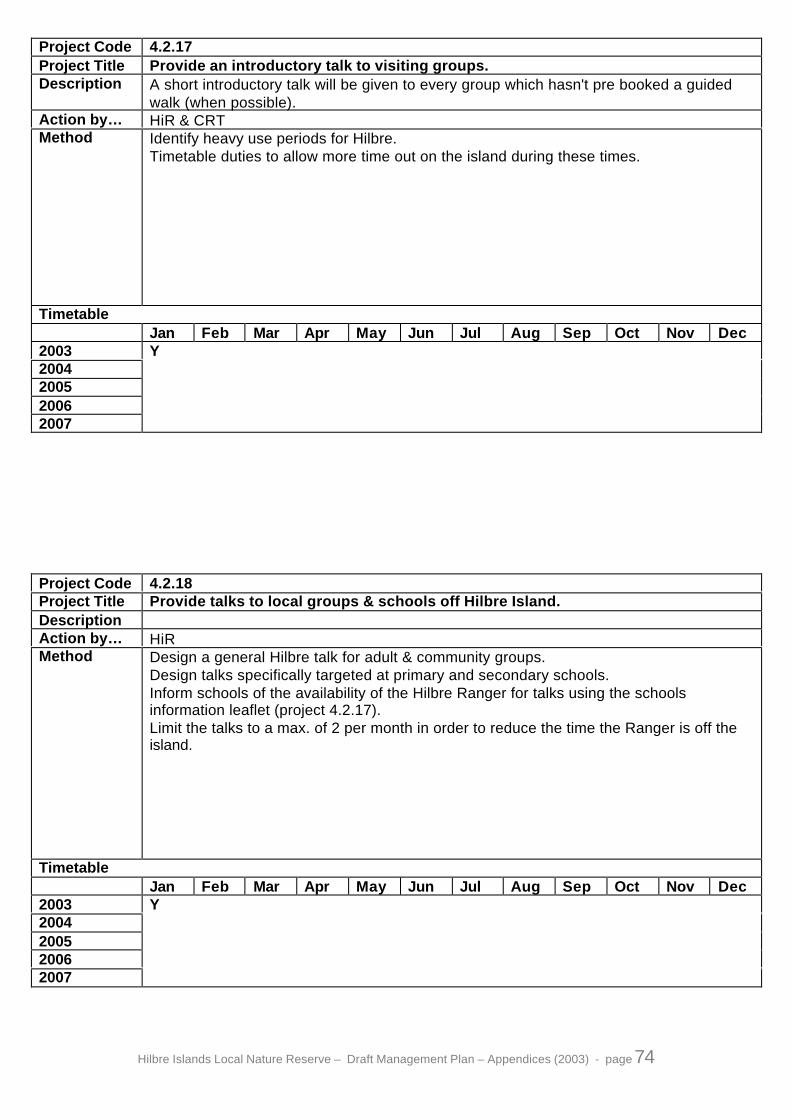
Hilbre Islands Local Nature Reserve – Draft Management Plan – Appendices (2003) - page 74
Project Code 4.2.17Project Title Provide an introductory talk to visiting groups.Description A short introductory talk will be given to every group which hasn't pre booked a guided
walk (when possible).Action by… HiR & CRTMethod Identify heavy use periods for Hilbre.
Timetable duties to allow more time out on the island during these times.
TimetableJan Feb Mar Apr May Jun Jul Aug Sep Oct Nov Dec
20032004200520062007
Y
Project Code 4.2.18Project Title Provide talks to local groups & schools off Hilbre Island.DescriptionAction by… HiRMethod Design a general Hilbre talk for adult & community groups.
Design talks specifically targeted at primary and secondary schools.Inform schools of the availability of the Hilbre Ranger for talks using the schoolsinformation leaflet (project 4.2.17).Limit the talks to a max. of 2 per month in order to reduce the time the Ranger is off theisland.
TimetableJan Feb Mar Apr May Jun Jul Aug Sep Oct Nov Dec
20032004200520062007
Y
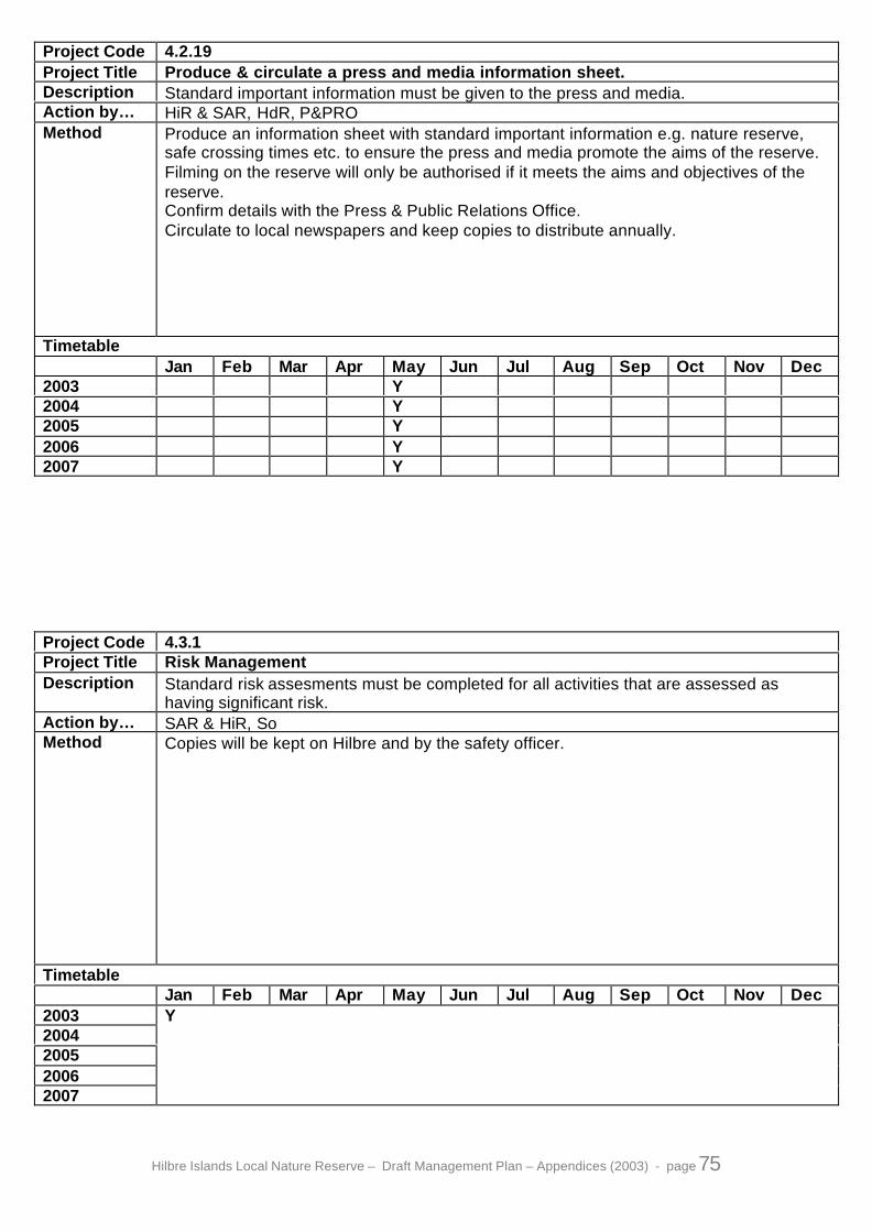
Hilbre Islands Local Nature Reserve – Draft Management Plan – Appendices (2003) - page 75
Project Code 4.2.19Project Title Produce & circulate a press and media information sheet.Description Standard important information must be given to the press and media.Action by… HiR & SAR, HdR, P&PROMethod Produce an information sheet with standard important information e.g. nature reserve,
safe crossing times etc. to ensure the press and media promote the aims of the reserve.Filming on the reserve will only be authorised if it meets the aims and objectives of thereserve.Confirm details with the Press & Public Relations Office.Circulate to local newspapers and keep copies to distribute annually.
TimetableJan Feb Mar Apr May Jun Jul Aug Sep Oct Nov Dec
2003 Y2004 Y2005 Y2006 Y2007 Y
Project Code 4.3.1Project Title Risk ManagementDescription Standard risk assesments must be completed for all activities that are assessed as
having significant risk.Action by… SAR & HiR, SoMethod Copies will be kept on Hilbre and by the safety officer.
TimetableJan Feb Mar Apr May Jun Jul Aug Sep Oct Nov Dec
20032004200520062007
Y

Hilbre Islands Local Nature Reserve – Draft Management Plan – Appendices (2003) - page 76
Project Code 4.3.2Project Title Display tide information in the Dee Lane Noticeboard.Description Safe crossing times to be changed daily.Action by… HiR & CRTMethod Tide table to be changed at the start of every month.
Mark for special attention any tide above 9 ½m.Hilbre Ranger or covering Ranger to change the recommended crossing times as earlyas possible each day.Due to operational necessity it may occasionally be appropriate to put two days tide timesup at once.
TimetableJan Feb Mar Apr May Jun Jul Aug Sep Oct Nov Dec
20032004200520062007
Y
Project Code 4.3.3Project Title Display information on safety & the importance of the reserve at beach access
points.Description Although primarily fulfilling a safety role, these will also provide information on the nature
conservation importance of the reserveAction by… SAR & CRTMethod Notice boards to be sited at the following beach access points:
- Sandy Lane- Dee Lane- Riversdale Road- Stanley Road- Kings Gap
Devise warning notices specific for each site.
TimetableJan Feb Mar Apr May Jun Jul Aug Sep Oct Nov Dec
20032004200520062007
Y

Hilbre Islands Local Nature Reserve – Draft Management Plan – Appendices (2003) - page 77
Project Code 4.3.4Project Title Update & circulate general pre-visit FREE information sheet.Description This leaflet will have important safety & ‘how to get there’ information.Action by… HiR & SAR, WCPMethod Review & revise leaflet to ensure information is correct and up to date.
Take special note of any safety or 'how to get there' information.Maintain supply at Visitor Centres, Wirral Sailing Centre and TiC's.
TimetableJan Feb Mar Apr May Jun Jul Aug Sep Oct Nov Dec
2003 Y2004 Y2005 Y2006 Y2007 Y
Project Code 4.3.5Project Title Maintain lifesaving equipment.DescriptionAction by… HiR & SAR, BLSMethod Lifebelts with lanyards to be provided at the following locations:
- Hilbre North End (2)- Hilbre South Beach (1) (bracket to be secured to concrete block)- Hilbre East Slipway (1)- Hilbre Telegraph Lookout (1)- Middle Eye (1)
Lifebelts and lanyards to be inspected weekly by Rangers and Beach Patrol.Any defect to be immediately reported to Beach Patrol, and Head Ranger via incidentreport forms.
TimetableJan Feb Mar Apr May Jun Jul Aug Sep Oct Nov Dec
20032004200520062007
Y

Hilbre Islands Local Nature Reserve – Draft Management Plan – Appendices (2003) - page 78
Project Code 4.3.6Project Title Provide First Aid cover.Description The Hilbre Ranger must hold a first aid certificate.Action by… HiR & SARMethod An internal, four-day first aid course must be applied for on acceptance of the Hilbre
Ranger post.On completion, the course must be renewed every 3 years.
TimetableJan Feb Mar Apr May Jun Jul Aug Sep Oct Nov Dec
20032004 Y200520062007 Y
Project Code 4.3.7Project Title Provide 24 hour emergency contact for the Hilbre Ranger.DescriptionAction by… HdR & WBC, SAR, HiRMethod A mobile phone and a mains and in-car charger will be provided.
This will allow 24-hour emergency contact with the Ranger as well as 24-hour contactbetween the Ranger and the emergency services.This connection with the Ranger must be used for emergencies only, and the numbermust not be given out to the public.
TimetableJan Feb Mar Apr May Jun Jul Aug Sep Oct Nov Dec
20032004200520062007
Y

Hilbre Islands Local Nature Reserve – Draft Management Plan – Appendices (2003) - page 79
Project Code 4.3.8Project Title Encourage and support the Rangers work as an auxiliary coastguard.DescriptionAction by… HiR & MCAMethod Ranger to be equipped and trained by Maritime & Coastguard Agency (MCA).
Ranger to attend coastguard training when applicable.
Coastguard incidents must take precedence over normal Ranger duties.
TimetableJan Feb Mar Apr May Jun Jul Aug Sep Oct Nov Dec
20032004200520062007
Y
Project Code 4.3.9Project Title Provide Lifeguard cover for the reserve.DescriptionAction by… WBC & BLSMethod To be implemented by the Beach Lifeguard Service.
This service should be targeted to cover the particular dangers due to the flooding tide inthe channels to the east of the islands and around Little Eye.
TimetableJan Feb Mar Apr May Jun Jul Aug Sep Oct Nov Dec
2003 Y Y Y Y Y Y Y2004 Y Y Y Y Y Y Y2005 Y Y Y Y Y Y Y2006 Y Y Y Y Y Y Y2007 Y Y Y Y Y Y Y

Hilbre Islands Local Nature Reserve – Draft Management Plan – Appendices (2003) - page 80
Project Code 4.3.10Project Title Provide firefighting equipment to all buildings with overnight accommodation.DescriptionAction by… HdR & SAR, Po-C&D, MFB, WBC-SO/BIMethod Water misting system to be fitted in :
- Telegraph House- Bunkhouse- Study Centre
(Misting systems in Telegraph House and the Bunkhouse were fitted in 2001)Fire extinguishers or blankets to be maintained under direction of the DepartmentalSafety Officer/Building inspector.
TimetableJan Feb Mar Apr May Jun Jul Aug Sep Oct Nov Dec
20032004200520062007
Y
Project Code 4.3.11Project Title Provide Firefighting training for the Hilbre Ranger.DescriptionAction by… HiR & SAR, WBC, MFBMethod An external, one day Basic Firefighting Skills course must be applied for on acceptance
of the Hilbre Ranger post.On completion, the course must be renewed every 2 years.
TimetableJan Feb Mar Apr May Jun Jul Aug Sep Oct Nov Dec
2003 Y20042005 Y20062007 Y

Hilbre Islands Local Nature Reserve – Draft Management Plan – Appendices (2003) - page 81
Project Code 4.3.12Project Title Provide a Land-Rover (or equivalent vehicle).Description A Land-Rover (or equivalent) to be available for the Hilbre Ranger to assist in rescues or
casualty evacuations were appropriate. A life jacket, throw line & megaphone will beavailable in the Ranger’s Land-Rover.
Action by… HiR & WBC, MCAMethod Ensure a Land Rover is available for use on Hilbre.
There are 2 Land Rovers dedicated to Hilbre, one in use and one at Cleveland St. depotbeing serviced and stored; when necessary, swap Land Rovers.The Local Authority supplies the throw line; the Maritime & Coastguard Agency providesthe lifejacket & megaphone.
TimetableJan Feb Mar Apr May Jun Jul Aug Sep Oct Nov Dec
20032004200520062007
Y
Project Code 4.3.13Project Title Maintain safe routes to places of interest on Hilbre and Middle Eye.Description Clear routes to Shell Beach, the ladder by the Tide Gauge, and maintain steps on Hilbe
and Middle Eye.Action by… HiRMethod Monitor state of each route at least once every 2 weeks.
Clear algae when necessary taking into account slippiness and high use times.Care must be taken and a wide path cleared after the concrete bridge on the route to theladder. This area becomes very slippy, and slopes steeply towards the tide gauge cutting.Cut steps where the rock slopes between the bridge & the ladder.Materials needed : - gloves & wire brushes - plastic dust-pan type brushes & yard brushesSteps on Middle Eye to be widened by spade edging and infilled with broken shells.Steep steps on West side of Hilbre to be replaced as necessary.An ideal task for volunteer groups, as the project will take too long for one person tocomplete.
TimetableJan Feb Mar Apr May Jun Jul Aug Sep Oct Nov Dec
2003 Y Y Y Y Y Y Y Y2004 Y Y Y Y Y Y Y Y2005 Y Y Y Y Y Y Y Y2006 Y Y Y Y Y Y Y Y2007 Y Y Y Y Y Y Y Y

Hilbre Islands Local Nature Reserve – Draft Management Plan – Appendices (2003) - page 82
Project Code 4.4.1Project Title Encourage public involvement in the care & management of Hilbre.DescriptionAction by… HiR & FoH, DEVWMethod Involvement of small groups, or individuals in the care & management of Hilbre can be
organised directly through the Ranger, or via the Friends of Hilbre.Organised groups who wish to help the island in a practical way can be accommodated inthe Bunkhouse, and can carry out practical work under supervision of the Ranger.
There are a limited number of weekends available, and groups that have demonstratedappropriate skills should be given priority, although some weekends should be left forgroups new to Hilbre.Some groups may not wish to stay overnight, and can therefore be booked during the 6weekends in the summer when a placement is in residence in the Bunkhouse.
TimetableJan Feb Mar Apr May Jun Jul Aug Sep Oct Nov Dec
20032004200520062007
Y
Project Code 4.4.2Project Title Support the Friends of Hilbre group.DescriptionAction by… HiR & SARMethod The Friends of Hilbre were set up during 2001. The Metropolitan Borough of Wirral,
through the Ranger service has been working in partnership with the group.
TimetableJan Feb Mar Apr May Jun Jul Aug Sep Oct Nov Dec
20032004200520062007
Y
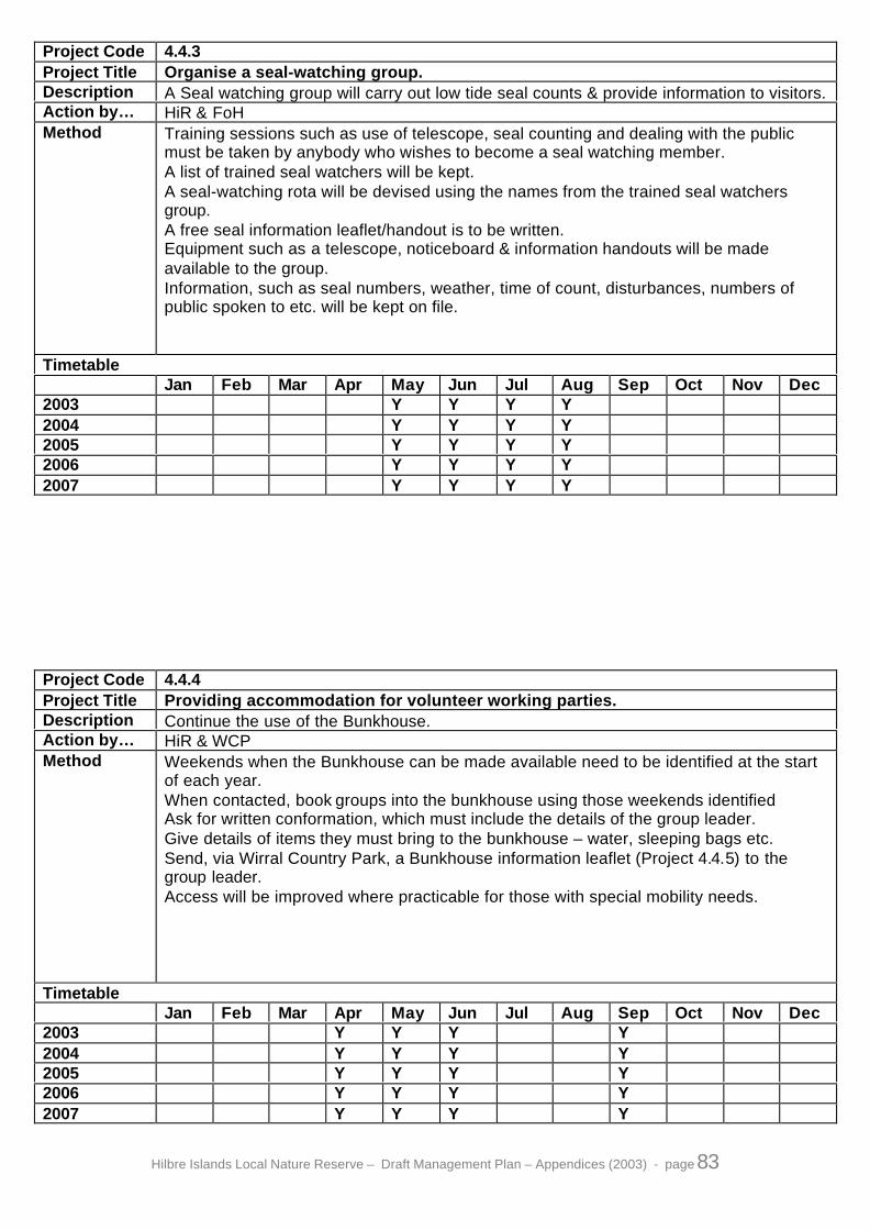
Hilbre Islands Local Nature Reserve – Draft Management Plan – Appendices (2003) - page 83
Project Code 4.4.3Project Title Organise a seal-watching group.Description A Seal watching group will carry out low tide seal counts & provide information to visitors.Action by… HiR & FoHMethod Training sessions such as use of telescope, seal counting and dealing with the public
must be taken by anybody who wishes to become a seal watching member.A list of trained seal watchers will be kept.A seal-watching rota will be devised using the names from the trained seal watchersgroup.A free seal information leaflet/handout is to be written.Equipment such as a telescope, noticeboard & information handouts will be madeavailable to the group.Information, such as seal numbers, weather, time of count, disturbances, numbers ofpublic spoken to etc. will be kept on file.
TimetableJan Feb Mar Apr May Jun Jul Aug Sep Oct Nov Dec
2003 Y Y Y Y2004 Y Y Y Y2005 Y Y Y Y2006 Y Y Y Y2007 Y Y Y Y
Project Code 4.4.4Project Title Providing accommodation for volunteer working parties.Description Continue the use of the Bunkhouse.Action by… HiR & WCPMethod Weekends when the Bunkhouse can be made available need to be identified at the start
of each year.When contacted, book groups into the bunkhouse using those weekends identifiedAsk for written conformation, which must include the details of the group leader.Give details of items they must bring to the bunkhouse – water, sleeping bags etc.Send, via Wirral Country Park, a Bunkhouse information leaflet (Project 4.4.5) to thegroup leader.Access will be improved where practicable for those with special mobility needs.
TimetableJan Feb Mar Apr May Jun Jul Aug Sep Oct Nov Dec
2003 Y Y Y Y2004 Y Y Y Y2005 Y Y Y Y2006 Y Y Y Y2007 Y Y Y Y

Hilbre Islands Local Nature Reserve – Draft Management Plan – Appendices (2003) - page 84
Project Code 4.4.5Project Title Produce a Bunkhouse Information Leaflet.Description A leaflet will be sent out to all groups who book the bunkhouse.Action by… HiR, SAR, WCPMethod Include in the document :
- information on the importance of the reserve- safety information- the group leaders responsibility whilst on the reserve- The Fire certificate permits a maximum of 10 people to stay overnight.- information about the amenities on Hilbre- a list of items which are provided by the Local Authority- a list of items the group must provide for themselves- contact numbers
TimetableJan Feb Mar Apr May Jun Jul Aug Sep Oct Nov Dec
20032004 Y200520062007

Hilbre Islands Local Nature Reserve – Draft Management Plan – Appendices (2003) - page 85
Abbreviations used in Project List
BLS Beach Lifeguard ServiceBWEA British Wind Energy AssociationCCW Countryside Commission for Walescontractor Contractor used for projectCRT Coastal Ranger TeamDERUG Dee Estuary Recreation Users GroupDEVW Dee Estuary Volunteer WardensEA Environment AgencyEN English NatureFoH Friends of HilbreHdR Head RangerHiBO Hilbre Bird ObservatoryHiMAG Hilbre Islands LNR Management Advisory GroupHiR Hilbre RangerHsC Hilbre sub-committeeLA-21 Local Agenda-21 OfficerLHG Local History GroupLiM Liverpool MuseumLiU Liverpool UniversityMCA Maritime & Coastguard AgencyMCS Marine Conservation SocietyMFB Merseyside Fire BrigadeMS Mammal SocietyNWNWFFC North Western & North Wales Sea Fisheries CommitteePo-C&D Principal officer-Client & DevelopmentPP Peninsular PaddlersP&PRO Press & Public Relations OfficeRSPB Royal Society for the Protection of BirdsSAR Senior Area RangerSD Star DesignTiC Tourist information CentresTOF Tam O'Shanter Urban Farmvols Volunteer groupsWBC Wirral Borough CouncilWBC-BI Wirral Borough Council-Building InspectorWBC-BM Wirral Borough Council-Building MaintenanceWBC-CO Wirral Borough Council-Conservation OfficerWBC-PC Wirral Borough Council-Pest ControlWBC-PD Wirral Borough Council-Planning DepartmentWBC-SO Wirral Borough Council-Safety OfficerWCP Wirral Country ParkWp Work placementWSC Wirral Sailing Centre
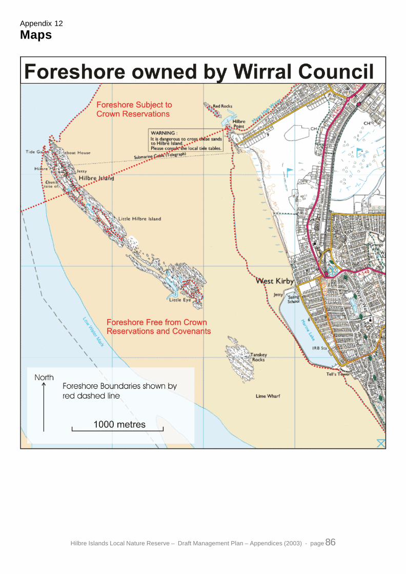
Hilbre Islands Local Nature Reserve – Draft Management Plan – Appendices (2003) - page 86
Appendix 12
Maps

Hilbre Islands Local Nature Reserve – Draft Management Plan – Appendices (2003) - page 87