highlands to coast park guide south coast region 3rd edition
TRANSCRIPT

Roxy, the brush-tailed rock-wallaby gave
birth to a joey, 4/9/08
www.environment.nsw.gov.au
HigHlands to coast Park guide20 HigHlands to coast Park guide
TRUTH THROUGH TESTINGThe brush-tailed rock-wallaby, a threatened species in NSW, now survives in only a few colonies. In the Shoalhaven area, their numbers appear to be declining.
In fact, DNA testing of scats (droppings) revealed that one “colony” was actually only one animal - a female aged 6 - 8. These are usually social animals but “Roxy” was destined to live out a lonely life without companions or breeding partner.
In a bold attempt to re-establish the colony, three wild brush-tailed rock-wallabies from the Hunter Valley area were introduced in November, 2007. It was hoped that “Adam”, “Rosie” and “Hunter” would join forces with Roxy and breed. But first Roxy had to accept these new kids on the rocks. National Parks staff have been watching the wallabies’ social interactions as carefully as parents at playgroup. All have survived and are interacting well.
The colony is being monitored by on-site
cameras and radio tracking. New tracking collar technology allows swift response to trouble. If the collar has not moved for 24 hours it sends a signal to observers.
Staff are also continuing an extensive fox baiting program in the wallabies’ territory.
WATCHING AND BAITINGManaged fox baiting is one method of reducing the numbers of these feral predators.
But how much does this help population numbers of any one native species?
A study of potoroos at Barren Grounds Nature Reserve is looking at the question.
Long-nosed potoroos are small macropods (kangaroo family).They live in thick, protective ground cover in heath and forests. Loss and fragmentation of habitat and predation by foxes have put them on the endangered list.
Project Officer Melinda Norton, with assistance from Project Officer Phil Craven
and fauna ecologist Dr. Andrew Claridge, is making a comparison study at two sites to try to establish whether fox control affects the abundance of long-nosed potoroos.
“We have been live-trapping potoroos in Barren Grounds Nature Reserve following fox baiting. We then repeat the trapping at Carrington Falls in nearby Budderoo National Park where there has been no baiting” said Melinda Norton. “After a time we will compare results from the two sites to see what sort of impact on the population the fox baiting has had.”
Live trapping and microchipping of the animals not only helps identification and understanding of distribution - it’s up close and personal. Handlers see individual temperamants (especially the aggressive ones that bite).
The project requires constant monitoring.
Fox baiting efforts will increase if it is found that fox predation is a major factor in the long-nosed potoroos’ survival.
New scientific techniques sometimes provide tools that can be useful in field research. The new information gathered is valuable for planning or adjusting management programes.
Clockwise from bottom right: Out of the trap into the bag –
a Barren Grounds potoroo.A brush-tailed rock-wallaby.
Pretty Beach, located at the northern entrance to Murramarang National Park, is renowned as an ideal place for water activities such as swimming, fishing, surfing and snorkelling. It has cabins and a great camping area right near the beach, in a natural setting where wildlife abounds in the safe environment of a national park.
The area’s largely undisturbed coastline with its sandy beaches, rugged headlands and rock platforms provides an ideal haven for those who enjoy peace and tranquillity.
Extensive forest and sheltered rainforest gullies around Durras Mountain are home to many animals. Eastern grey kangaroos, swamp wallabies and the occasional sugar glider can be seen at dawn and dusk when they feed. There are 90 species of birds in and around the area including sooty oyster catchers on the rock platforms, sea eagles diving for fish and a variety of honeyeaters in the surrounding woodland.
Tall spotted gums forest is a feature of the park. The area around Pretty Beach also has extensive heathland in the thin sandstone soils on top of the cliffs where there are wildflowers in spring and summer.
LOCATIONPretty Beach is located in Murramarang National Park approximately 3 hrs drive south of Sydney and 2.5 hrs from Canberra. It is situated between Ulladulla and Batemans Bay, 2 km from the village of Kioloa. Turn off the Princes Highway at Termeil, travel east to Bawley Point then head south past Kioloa and follow the signs to Pretty Beach. The access road is all weather two-wheel drive.
BUSHWALKINGThere are a variety of walks around Pretty Beach and the surrounding hinterland. Some of the most popular ones are:
Pretty Beach to Snapper Point — returning the same way. 1–2 hrs with panoramic views of the coastline and interesting rock platforms to explore.
Pretty Beach to Pebbly Beach via Durras Mountain and Snake Bay. Return the same way or follow a negotiable route along the coastline. Take something to eat and drink, sunscreen and a hat.
WALKS CLOSE TO PRETTy BEACHMurramarang Aboriginal Area — located a short drive north of Pretty Beach (refer map). This midden site is important because of its size, age and diversity of cultural remains.
Red Head Road
WestLake Conjola
Conjola Lake
Lake Conjola
Cunjurong Point
ManyanaBerringer Lake
Lake Conjola Entrance Road
Inyadd
a Beac
h
Cunjurong Beach
Washerwomans CreekWasherwomans Beach
Boat Harbour Beach
Nerrindillah Lake
Dee Beach
Flat Rock Beach
Conjola National Park
FishermansParadise
Berrin-ger
Pattimores Lagoon
Conjola National Park
Monument Beach
Berrara Beach
North Bendalong
Bendalong
Boundar
y R
d
Davies Rd
Twelve Mile Road
MortonNational Park
Swan Lake
Powerline Easement
Booderee National Park
Conjo
la B
each
Stringybark R
d
Cudmirra
h Beach
Yatteyattah NR
Mondayong Road
Wen
ts
Roa
d
Narrawallee Creek Nature Reserve
to Milton and Ulladulla
Man
yana
Beach
(4WD)
to Gorge Boyd Lookout and Granite
ford
to Nowra
Conjola NaTioNal Park
Situated between Lake Conjola and Sussex Inlet, Conjola National Park (map ref. G8 see page 10) includes much of the foreshores of Swan and Conjola lakes. The park protects a diverse landscape consisting of three distinct environments: the coast, the estuaries and inland sandstone country. It has a particularly large variety of vegetation communities and is home to over a dozen threatened species. Large areas of woodland and heath produce a mass of wildflowers in spring.
Aboriginal people have utilised the resources of the area for thousands of years, especially the lakes and along the coast where there is an abundance of archaeological sites such as middens and artefact scatters.
The main picnic area is located at the south end of Monument Beach. Nearby is a monument to those who perished when the clipper, the ‘Walter Hood’ was wrecked on a reef just off the coast in 1870.
Walkers will enjoy the half-day walking track from Berrara to the picnic area at Monument Beach. Return along the beach. A number of swimming spots can be accessed through the national park including Swan Lake at Medlyn Avenue, Swanhaven.
Camping is not permitted in the national park however there is camping and accommodation in the surrounding villages and towns.
Phot
o: M
Van
Ew
ijk.
Signs along the track explain its special significance.
Pigeon House Mountain/Didthul is to the west in Morton National Park. The walk takes about three hours return and provides spectacular views of the coastline and wilderness. It is very steep in parts with ladders at the top.
Ask the manager for information regarding other walks in Murramarang National Park and nearby.
Ranger-guided activities are organised during school holidays with programs available on request.
FOR INFORMATION: on camping fees and cabin bookings ph: (02) 4457 2019
FOR MORE INFORMATION: contact visitor information centres in Nowra and Ulladulla. (see page 1)
Science Helps Hoppers:
FOR INFORMATION about parks in the South Coast Region :
Nowra (02) 4423 2170Fitzroy Falls (02) 4887 7270Minnamurra (02) 4236 0469 Ulladulla (02) 4454 9500
www.evironment.nsw.gov.au
HigHlands to coastPark guide
SEE INSIDE FOR:
Parks to Visit, Walks, Maps
Pages 2 - 5
40th ANNIVERSARy NAtIONAl
PARkS AND WIlDlIFE SERVIcE
1968 - 2008
Pages 6 - 13
hIghlANDS NAtIONAl PARkS
Kangaroo Valley .................6
Bundanoon ........................8
Highlands Highlights: .....12 escarpments & waterfalls
Bungonia ..........................13
Pages 10 & 11
MAP OF REgION
Page 14EDucAtION PROgRAMS
Minnamurra Rainforest Centre
Pages 15 - 20
cOAStAl NAtIONAl PARkS
Seven Mile Beach ............15
Lake Wollumboola ..........15
Jervis Bay .........................16
Marine Parks ....................17
Murramarang ..................18
Depot Beach .................... 19
Conjola ..............................20
Pretty Beach ....................20
DaTa DriVES MaNagEMENT
Careful exploration.
South CoaSt region3rd edition
Phot
os: M
. Nor
ton.
Out of the trap into the bag – a Barren Grounds potoroo
Capturing The view to the south. Pretty
Beach
Phot
os: M
. Van
Ew
ijk.

HigHlands to coast Park guide 32 HigHlands to coast Park guide
The National Parks and Wildlife Service has turned forty and we can look back on forty years of change and improvement. This change and variety are reflected in the history and diversity of the parks and reserves in the South Coast region.
on this and the following page staff members talk of their time in the Service and of one of our great NSW's national parks and the man who helped create it.
The Making of Morton
Top left, Mark Morton Senior. Top right, Mark Morton as a young
boy sitting on the edge of the Shoalhaven bridge. Opposite right,
Fitzroy Falls and Lady Hordern Falls. Bottom left, Mark Morton Junior.
As someone lucky enough to work for the National Parks and Wildlife Service I often have the opportunity to venture into the 190,000 ha Morton National Park. It is a place one could never grow tired of.
Morton National Park has everything, from the massive to the minute – roaring waterfalls plunging 90 metres into rainforest gullies and microbats barely bigger than a large moth. There are escarpment edges ablaze with wildflowers, massive eucalypts towering above tree fern thickets and tiny orchids amongst the forest litter. Above all it has a profound sense of the Australian bush.
The park is part of the ancestral home of the Gundungara people of the Southern Tablelands and the South Coast people of the Dharawal/Dhurga language group. Research has shown that these people lived in these areas at least 20,000 years ago when the coast was many kilometres east
also argued for enlargement of this area.
With his usual enthusiasm Mark Morton set about enlisting support from the existing reserve trusts, prominent local citizens and the local and Sydney press. His stated aim was to: “…do something to preserve for generations to come the wonderful specimens of our native animals, birds and flora which, as everybody knows, are in danger of total disappearance”. Morton’s persuasiveness and commitment to the reserve were shown at a meeting in Moss Vale in 1937. It attracted 200 people representing all elements of the community. A motion to proceed with the reserve was carried unanimously.
Morton only just survived to see the gazettal of the Primitive Reserve on 13th September 1938. He died 14 days after it was created. He had had time, however, to pass his passion and enthusiasm on to a group of men and women, including his son, who became staunch defenders of the Reserve. They would need every bit of that passion and enthusiasm in the years to come.
For the next 15 years, the trustees battled repeated attempts to revoke large parts of the reserve to allow logging. Despite the
intense pressure applied for harvesting of timber during the Second World War and the post war building boom, they never gave an inch and in 1954 all attempts to allow logging were abandoned.
The story of the Reserve since then has been one of expansion – one of the key figures involved being the Hon. Tom Lewis. It was through his efforts that the National Parks and Wildlife Service was created in 1967 and Morton Primitive Reserve became Morton National Park. The Park now stretches from Fitzroy Falls in the north to Pigeon House Mountain/Didthul and The Castle in the south. It is one of the State’s conservation icons.
When Mark Morton and those who assisted him first proposed the reserve, they promoted the idea that the bush could be valued for its intrinsic beauty.
I experienced that intrinsic beauty this morning at the Fitzroy Falls lookout. It was the first clear day after continued rain. The eucalypts shone in the early light, water roared over the falls and mist hung around Mount Carrialoo. I thought about the incredible foresight of Mark Morton and the other men and women who established and protected this place. And I thought
how lucky present and future generations are to have had people so far ahead of their time in their appreciation and love of the Australian landscape.
Tony Moody Senior Field Supervisor Highland Area
The historical information for this article is extensively based on chapters written by Mark Morton II, Colin Watson and Wilf Hilder in “Fitzroy Falls and Beyond” published by The Budawang Committee in 1988.
Information on traditional owners was provided by Rod Wellington, Aboriginal Sites Officer with the NSW Department of Environment and Climate Change.
and the reserve extended in 1877. Fitzroy Falls was declared a Reserve for Public Recreation in 1889.
But how did these small reserves come to form the nucleus of the national park we have today and how are we so fortunate to have such an irreplaceable part of the State protected?
The outstanding figure in this story is Mark Morton, a man of vision and energy. Born on the Berry Estate at the mouth of the Shoalhaven in 1865, Morton became familiar with the country which would become the National Park when he and his brother rode from Nowra to school in Goulburn via Meryla Pass. It seems that, as a child, Morton was taken along on a koala hunt, an experience that appalled him and instilled a life-long passion for protecting wildlife.
Mark Morton was elected to the NSW Legislative Assembly in 1901 and served as a member, with only two breaks, until 1938. In 1937 he proposed the amalgamation of crown land, reserves and some small holdings into a National Reserve of 60,000 acres (about 24,000ha) His proposal was supported by Myles Dunphy of the National Parks and Primitive Areas Council who
of its present location. The melting of the polar ice caps and inundation of coastal lands by the rising sea level would have been felt over many generations until the sea level stabilised about 5,000 years ago.
Evidence of the long occupation can be seen in sites recorded across the park such as grinding grooves and ceremonial sites. Aboriginal knowledge of this country is preserved in archival records and within the local Aboriginal community who retain a connection to special places within this landscape.
Europeans started investigating the gorges and ravines from around 1818, with Dr Charles Throsby being shown Meryla Pass, a route from the Highlands to the coast, by Timelong, a coastal Aborigine. The Europeans were quick to appreciate some of the more spectacular features of the escarpment country – the Bundanoon Gullies were reserved in 1824
reflectionson 40 Years
In response to continued and increasing popularity of the area, NPWS has prepared a bushwalking and camping strategy for the Budawangs in Morton National Park.
A copy of the strategy can be viewed at www.environment.nsw.gov.au
Phot
os p
rovi
ded
by th
e M
orto
n fa
mily
.
Phot
o: M
Van
Ew
ijk.

1824 Bundanoon Gullies reserved
1879 Australia's first National Park declared. Renamed Royal National Park, 1955
1886 Jenolan Caves Reserve declared
1889 Fitzroy Falls declared a Reserve for Public Recreation
1896 Minamurra Falls reserved for public use
1903 Native Animals Protection Act
1927 Wildflowers and Native Plants Protection Act
1932 National Parks and Primitive Areas Council formed
1938 Morton Primitive Reserve gazetted
1944 Kosciusko State Park reserved
1948 Fauna Protection Act passed First Fauna Reserves
1956 Barren Grounds Nature Reserve gazetted
1957 National Parks Association formed
1967 NPWS established
1971 Seven Mile Beach National Park reserved
1971 Aboriginal Sites Register set up
1973 Murramurrang National Park reserved
1979 Protests against rainforest logging culminate in State inquiry
1986 Budderoo National Park gazetted
1995 Threatened Species Conservation Act
1995 Jervis Bay National Park gazetted
1996 Act to provide for Aboriginal Ownership of land of indigenous cultural significance
1998 Jervis Bay and Solitary Islands declared Marine Parks
2001 Introduction of Threat Abatement Plan to control foxes and protect biodiversity
2007 NPWS becomes part of DECC
HigHlands to coast Park guide 54 HigHlands to coast Park guide
PhIl hAhN
When and why did you join the National Parks and Wildlife Service?
I began on 9th April 1973, so I have been with the Service for 35 years. Joining was accidental, really. After the HSC I had chosen
the public service as one career option and NPWS was the first to contact me. My ideals, with regard to the environment, have developed with the job.
What are the main aspects of your role?
The title is Leasing Concessions and Revenue Manager. I look after leasing and licensing issues for the Region, for example, applications to install telecommunication towers, pipelines and other public infrastructure in a park or to create access easements through a park to private land. The role includes legal work and managing issues associated with important public infrastructure to comply with our legislative framework. In an ideal world a
lot of this infrastructure would not be in parks and reserves. The revenue side involves the provision of advice on business planning matters.
could you describe any special interests?
I’ve been lucky I ended up in NPWS, with opportunities to grow and develop new skills. I have had a number of jobs, for example District Administration Manager. Now, my role is more specialised. I enjoy using my legal, written communication and diplomacy skills to negotiate and to convey complex information to another party so that they understand the more stringent rules that often apply to their activities in national parks.
could you mention any achievements or improvements over your time in NPWS?
NPWS generally has come a long way since I started. It is now a highly professional organisation, run very well in the region. There is more public and political awareness and appreciation of the importance of environmental matters. Managing property and leasing matters to achieve outcomes that are in the best interests of the NPWS is very satisfying.
DAVE cOllINS
When and why did you join the National Parks and Wildlife Service?
Since joining the Service in 1973, I have worked in a range of positions and communities across NSW.
What are the main aspects of your role?
As a Senior Ranger, fire management, I co-ordinate the development of fire management strategies for each reserve in the South Coast Region. The aim is to balance fire protection and conservation, to focus on the need to protect life and property whilst applying fire regimes that sustain our Region’s considerable diversity of flora and fauna.
I look forward to continuing this work.
could you describe any special interests?
In terms of fire management, the challenges of living in a fire prone landscape, managing the risk to life and property and dealing with severe bush fire events are all multiplied by the now customary
drought and the uncertain future of climate change.
Improving fire management will require cooperation and better understanding of fire and its effects. The NPWS is part of an effort to better understand fire behaviour and natural area resources and to understand and improve community perceptions about bush fire, risk and responsibilities. All this helps prepare for and combat bushfires more safely and effectively.
could you mention any achievements or improvements over your time in NPWS?
When I started as a ranger there were about 50 reserves across the State. Now there are over 50 in the South Coast Region alone. To manage them the NPWS must make best use of available resources. Also during my career, the NPWS has become a significant contributor to local employment and local economy – especially in rural areas.
The most significant change over this time has been in the community’s understanding of the need for the natural area reserve system. Extending this understanding, of the importance of the reserves to a sustainable future, is the key to continuing community support for NPWS management of these reserves, for present and future generations.
MElINDA NORtON
When and why did you join the National Parks and Wildlife Service?I joined at the beginning of 1996 at Broken Hill, as a Technical Officer working on the yellow-footed rock-wallabies
at Mutawintji. This was a few months after I did a week of volunteer work on the project and I just went on from there. I can’t say I was especially targeting working for National Parks, it just kind of jumped out at me, but I couldn’t ask for better - it’s wonderful. I love working for National Parks and I am amazed how well it has turned out.
What are the main aspects of your role?
My title is Project Officer. I am in charge of special projects, primarily dealing with animal or plant pests and threatened species. These are research but also practical projects: identifying the problem, working out how to approach fixing it, implementing the control, setting up monitoring to see how your actions are working and then adjusting
management. To help a threatened species, for example brush-tailed rock-wallabies, we conduct fox control in a number of areas then monitor whether foxes are being reduced and whether brush-tailed rock-wallabies are becoming more abundant.
could you describe any special interests?
A general highlight was working on yellow-footed rock-wallabies at Mootawingee. My interest in brush-tailed rock-wallabies followed. Releasing the brush-tailed rock-wallabies from the Hunter Valley was a highlight - but also a great stress.
It’s good to see a general wildlife effect during fox control, say more bandicoot diggings, even though there is still a way to go for the targeted threatened species.
could you mention any achievements or improvements?
The fact that we still have brush-tailed rock-wallabies is an achievement for the whole region, as was feeding our experiences in rock-wallaby management into the Fox Threat Abatement Plan.
I hope that threatened species will continue to get the attention they deserve.
kRIS cARRIAgE
When and why did you join the National Parks and Wildlife Service?
I joined in August 2002 when I became an Aboriginal Cadet Ranger at Ulladulla. I graduated and am now a fully fledged Ranger.
I joined because of 1) my love for the natural environment 2) my Koori background, growing up with respect for the land and sea and connection to them 3) my desire to work on country. So, it was natural to fall into the role of custodian – the ranger role seems perfect.
What are the main aspects of your role?
My title is Ranger, which is a multi-tasking job. you need problem solving and communication skills. I’m a people person, from an extended family, so it comes naturally to me to deal with diverse groups of people, from park neighbours to special interest groups like ANU archaeologists who visit Murramurrang Aboriginal Area, for its education and research value.
Part of the office work is following up actions in Plans of Management; for example, to upgrade the Cullendulla Creek boardwalk means applying for a Marine Parks permit to work by barge below the mean high water mark.
could you describe any special interests?
Although I am a mainstream Ranger, I have a special interest in cultural heritage and community involvement.
Another highlight is conservation work, pest and weed management: for example Bitou Bush spraying in Cullendulla Creek Nature Reserve - reducing densities from 40% to 1% - being able to tick that box in the Plan of Management. That is very satisfying.
could you mention any achievements or improvements?
One would be the setting up of the Aboriginal Involvement Working Group as a positive way of maintaining relationships with the Aboriginal community and ongoing cultural heritage management.
I’d like to see more co-management between the local Aboriginal communities and DECC in our region…everywhere.
Work is diverse. Clockwise from top right: management planning; revegetation at Greenfield Beach, Jervis Bay National Park; fire hazard control; whale rescue exercise; fire management training.
Reflections on 40 years (cont.)
Change, Challenge and growth:STaff Talk of THEir TiME iN THE SErViCE.
Phot
os: D
ECC.

The remains of stone farm walls and stone flooring can be seen along this final part of the walk. Down from these ruins is a grassy flat studded with casuarinas (C. cunninghamii).
With water from yarrunga Creek nearby (boil before drinking), the flat makes a good picnic or overnight camping spot. But the area is popular in the evening - it has to be shared with eastern grey kangaroos, wombats, swamp wallabies and possums. Return the same way. Please be sure to take out all rubbish.
There are no toilet facilities on this track – bury waste at least 100metres from water, trail and campsite. Avoid lighting fires. For minimal impact camping regulations and information see camping section, page 8.
THREE VIEWS WALK12km return. 5 hours. Easy walk.
Kangaroo Valley has many views looking up to the north and east at the magnificent sandstone escarpment cliffs. The Three Views trail is the perfect complement: looking down from the cliffs over the valleys to the south and west. The trail leads to three different, expansive views over
the Shoalhaven Gorge towards the Ettrema Wilderness.
Plan to spend the whole day if you wish to see all three views. If you only have time for one, try the 2 hour return walk to the Shoalhaven River View, one of the most spectacular in the Kangaroo Valley area.
WARNINg: unfenced cliffs. keep away from cliff edges. Supervise and restrain children at all times. Sandstone rock is weak and can fracture and crumble without warning.
HOW TO GET THEREThe Three Views trail entrance is about 20km from Kangaroo Valley Post Office. From the northern end of the village, turn into Tallowa Dam road. After the 60 kph sign watch for the low gate in a cutting on the left hand side of the road. Walk past the gate, up to where the Trail begins. The sign, visible from the gate, has a map of the tracks. Take the left turn for the Shoalhaven View; the right turn for the other two views.
THE WALKAlong the Three Views Trail there is plenty to see on the journey as well as the destination.
Birds of prey such as wedge-tailed eagles may be seen riding the updrafts between the cliffs and the river. Their acute eyes can detect prey hundreds of metres below. Sometimes sea eagles come inland to hunt for freshwater perch. The tall trees of the valley are home to thenocturnal yellow-bellied gliders, that travel their arboreal highways to feed on their preferred sap and leaf varieties. The gliders are the preferred prey of the large powerful owl.
The sandstone of the escarpments has produced a thin, dry soil with rocks close to the surface. The trails lead through a diverse community of plants especially adapted to these difficult, nutrient poor conditions. An example is the yellow bloodwood tree (Corymbia eximia), with its large thick leaves and creamy flowers, which grows here in a dwarf form. Always interesting in their variety, these plant communities are especially impressive when massed with flower, usually from mid winter to early spring.
The flowers are not only a feast for human eyes: many birds, insects and small marsupials depend on this rich food source of nectar and pollen. Honeyeaters of all sizes migrate to the feast: the tiny eastern spinebill, through to new holland, yellow-faced and slightly larger lewin’s to the noisy, bossy wattlebirds, all swoop about the heath gathering their day’s energy sip by sip. Then there is the myriad of insects, feeding and fed upon, including the fascinating flower wasps and nectar feeding beetles such as the spotted flower chafer.
HigHlands to coast Park guide 76 HigHlands to coast Park guide
Kangaroo Valley is sheltered by national parks and nature reserves that preserve the superb escarpment scenery and the special feel of the valley.
Though Kangaroo Valley village is in a hollow, it is far from sleepy; it has history but it is very up to date. Long a popular tourist destination, the Valley is now actively encouraging sustainable tourism, a very appropriate concept for a place whose history, inspiration, landscape and life is so linked to the surrounding bushland. Kangaroo Valley was the first mainland town to be plastic bag free; now climate change amelioration, a carbon neutral campaign and nature-based tourism ventures are on the agenda. An example is the plan to celebrate the wooden suspension bridge’s 110th birthday with a long term memorial - the planting of 110 trees native to the area.
Visitors to the Valley have many options:
There is plenty of physical action - walking, canoeing, bike riding, horse riding, swimming and fishing. There is also a great range of bushwalking in the surrounding national parks (Morton, Budderoo, Bugong) and nature reserves (Kangaroo River,
Cambewarra Range and Barren Grounds).
There are two big music and arts events in the Valley each year: the Kangaroo Valley Arts Festival and the Folk Music Festival.
And of course, there is wining, dining and simply relaxing amid magnificent scenery.
KANGAROO RIVER FIRE TRAIL8km return. 6 hours. Easy walk,some steep parts. this is not a loop trail. Return the same way.
HOW TO GET THEREThe start of the trail is 15 km from the Kangaroo Valley Post Office. At the northern end of the village, turn into Tallowa Dam road. Look for the Fire Trail sign on the right hand side, where there is a wide verge for parking.
THE WALKThe trail is level at the start, passing through sandstone country bearing a typical vegetation of scribbly gums (Eucalyptus haemostoma)- showing on their trunks the wandering tracks of the scribbly gum moth larvae - and bloodwoods (Corymbia gummifera) with their scaly bark. There is a mixed understorey including Banksia spinulosa, pink star flowers (Crowea exalata) and the yellow conesticks (Petrophile spp) and drumsticks (Isopogon spp).
At the ridge, the trail descends steeply through wonderful, water-carved sandstone rocks. These rocks trap water, debris and soil and so provide conditions for the many ferns, king orchids and other dendrobiums that grow here - a marked change from the dry vegetation above. The vegetation then opens out again, but the trail remains steep. Allocasuarina littoralis, food trees of the threatened glossy black cockatoos, grow here.
By the river, opposite Beehive Point there is a level area. The rocks at the water’s edge make good basking places for water dragons. Patient observers may see a sacred kingfisher perched by the water, yellow-tailed black cockatoos in their family groups and a variety of small birds.
Be aware that the river here is part of a dam system; water levels may vary significantly.Return the same way.Please be certain to take out all rubbish.
GRIFFINS FARM FROM JACKS CORNER 12km return. 6 hours.this is not a loop trail. Return the same way.this is an easier walk than the kangaroo River Fire trail, although it has some steep spots.
HOW TO GET THEREFrom the Kangaroo Valley Post Office drive 14km along Bendeela Road and Jacks Corner Road. Leave the car at the gate with the Morton National Park sign. After the gate, bear right onto Griffins Fire Trail. About 100 metres along, the Beehive Point trail opens to the left, go past this, continuing ahead on the Griffins Fire Trail all the way.
THE WALKThe walk is level for about 1.5km through open woodland of scribbly gum (Eucalyptus haemostoma), stringybark (Eucalyptus spp.) and bloodwood (Corymbia gummifera) with occasional waratahs (Telopea speciossisima) in the understorey. The trail then descends through boulders, some with clinging rock orchids, and winds down the ridge to yarrunga Creek. Here are water gums (Tristaniopsis laurina) and the bottlebrush of damp places (Callistemon salignus).
In order to continue to the ruins it is necessary to cross yarrunga Creek. this crossing is rocky underfoot, slippery and may be deep. It should not be attempted when the creek is in flood.
On the other side of the creek grow cool rainforest species such as ferns, brown beech (Pennantia cunninghamii), blackwattle (Callicoma serratifolia) and coachwood (Ceratopetalum apetalum).
One of the interests of this walk is to see the extent of revegetation of areas that were once cleared.
Discovering kaNgaroo VallEY
Maps for the walks on this page are in the Walks Guide “Kangaroo Valley and Adjacent National Parks”
Brochures, walks guides and other information are available at:
National Parks and Wildlife Service Fitzroy Falls Visitor Centre Nowra Road Fitzroy Falls NSW 2577 Ph. (02) 4887 7270www.evironment.nsw.gov.au
Kangaroo Valley Information Kangaroo Valley Fudge House 158 Moss Vale Road Kangaroo Valley www.visitkangaroovalley.com.au
Phot
o: M
. Van
Ew
ijk.
3 Walks inkaNgaroo VallEY
Above Lake yarrunga, Three Views Walk.
Phot
o: D
ECC.
Phot
os: D
ECC.
Walkers on the Three Views Walk.
Needle bush (Hakea sericea).
Sydney boronia (B. ledifolia).
yellow bloodwood (Eucalyptus eximia).
Native iris (Patersonia spp.).

HigHlands to coast Park guide 98 HigHlands to coast Park guide
ERITH COAL MINE TRACK (1 hr return) Start: Gambells Rest • steep
This short, steep walk through woodland, heath and rainforest leads to a mine that was open from the 1860s to 1915. The metre thick coal seam was of poor quality and only used for goods engines. For safety reasons, fencing prevents entry to the mine. This walk can also be undertaken from the Erith Coal Mine car park off Echo Point Road.
ECHO POINT AND LOVERS WALK (1 hr loop) Start: Echo Point picnic area • Grade: easy
The Lovers Walk begins at the Echo Point picnic shelter. Follow the track to Bonnie View for a spectacular panorama. Return along the road, passing the Wishing Well on your left. Where the road divides, keep left and then left again back to the picnic area.
MOUNT CARNARVON TRACK (30 mins return) Start: Echo Point picnic area • Grade: easy, some steps
A short, pretty walk through bushland to the escarpment returning the same way.
FAIRy BOWER FALLS WALK(1.5 hrs return) Start: Gambells Rest picnic area or Fairy Bower Falls car park • Steep in parts
Commence your walk at the Gambells Rest picnic area. Walk through the picnic area until you reach the road. Head right along the road until you come to the Fairy Bower Falls sign on your left. Follow the track down to the creek where you will delight in the lush, green rainforest. To walk to the bottom of the falls, cross the creek, follow the ridge line where the track winds its way across a metal walkway down to the junction of the Amphitheatre Walk at Nicholas Pass. Turn right and this will take you to the bottom of Fairy Bower Falls. You can return the same way or continue on to the T-junction with Bundanoon Creek track. Turn right here and climb this steep track to Tooths Lookout, turn right and follow the sign back to Gambells Rest.
You can also commence your walk at the Fairy Bower Falls car park by following the signs down to the creek and Fairy Bower Falls (as above). You can return the same way or at the bottom of the Falls, take the track to the T-Junction of the Bundanoon Creek walk, turn right here. Climb this steep track to Tooths Lookout, turn right and follow the sign back to Fairy Bower Falls car park.
DIMMOCKS CREEK WALK (30 mins return) Start: Dimmocks Creek car park • Grade: easy
Short walk to Dimmocks Creek (return same way).
GLOW WORM GLEN WALK(1 hr return) Start: William Street; alternative access exists via Riverview Road • Grade: easy/steep
Glow worms are only visible after dark. A torch is essential to negotiate the track safely. To help protect the glow worms, turn off torches once you reach the glen, keep quiet and stay on the platform. Guided walks are conducted during school holidays and group tours on request.
William Street cul-de-sac is No Parking.
CampingThe camping area is located at Gambells Rest. you must book and pay in advance through the Fitzroy Falls Visitor Centre on (02) 4887 7270 9.00am–5.30pm 7 days. A public phone is located at the Bundanoon Post Office.
Please note that in addition to camping fees, a day park use fee also applies to campers.
Driving around the national park is a great way to reach some beautiful viewing points within a few minutes. If you follow the road down to Echo Point, you can see a panoramic view into Ettrema Wilderness.On your return, detour via Grand Canyon to see more of the dramatic scenery of the Bundanoon Gullies.
Please drive slowly (30 km/hr) as cyclists and walkers use the roadways.
You can also reach many of the lookouts by bicycle. Access roads are suitable for bikes but please stay off walking tracks!
Alternatively you can return to Gambells Rest via Fairy Bower Falls walk or continue on to the T-junction with the Bundanoon Creek track and turn right. Climb this steep track to Tooths Lookout, then follow the signs back to Gambells Rest.
RIVERVIEW WALK (40 mins return Riverview Lookout) (1.5 hrs return to Glow Worm Glen) Start: Amphitheatre car park • Grade: medium
A pretty walk across Fern Tree Gully through eucalypt forest to Riverview Lookout. Continue to Glow Worm Glen by following Riverview Rd north until it meets the Glow Worm Glen track. Follow this track and turn right at track junction to Glow Worm Glen (day time only).
BUNDANOON CREEK TRACK(2 hrs return) Start: Tooths Lookout car park • Grade: very steep Follow the track down a very steep incline (past the Fairy Bower Falls turn-off) to Bundanoon Creek. Cool off in the creek before the steep climb back. Make sure you allow plenty of time to complete this walk in daylight.
AMPHITHEATRE WALK(3 hrs loop) Start: Gambells Rest car park • Grade: medium, steps
Take the road outside the park (Gullies Road) to Riverview Road and turn right. Follow the road to the junction, turn right and follow the sign to the Amphitheatre. Follow this track (Nicholas Pass) under the cliff and stop off at Fairy Bower Falls. Return the same way.
Bundanoon’s SPECTaCular SCENErY
there are several car-based and bush camping sites in our region. these areas are not necessarily identified on our park brochures.
Listed below are some of these locations with suggestions on ‘Minimal Impact Bushwalking/camping’ when visiting these areas.
CAR-BASED CAMPINGWog Wog (map ref. C9, see page 10) in Morton National Park. Facilities include: pit toilets and fire places
long gully (map ref. D9, see page 10) in Budawang National Park. Facilities include: pit toilets and fire places
Blue gum Flat (map ref. E10, see page 10) in Morton National Park (30m walk from car). Facilities include: pit toilets
North head (map ref. E13, see page 10) in Murramarang National Park. Facilities include: pit toilet
Other camp grounds are covered in articles in this newspaper.
WALK-IN CAMPINGWalk-in camping can be undertaken throughout most of our parks as long as you camp 100m from any fire trail, access road, lookout or parking area and 500m from any picnic area, camping area or village. Check with your nearest NPWS office for more detailed information.
Camping is not permitted on any beach or where there are signs indicating “NO CAMPING”.
Camping is not permitted in Nature Reserves.
MINIMAL IMPACT CAMPING• Camp on hard surfaces rather than boggy
or grassed areas and keep at least 30 m away from watercourses and tracks.
• Camping in caves should be avoided due to environmental and cultural heritage impact and the risk of disease from animals that may have used the caves.
• Use a fuel stove when camping. They are faster, easier to use in wet weather and don’t leave scars on the landscape. Gathering wood causes damage to the environment.
• Do not cut, clear or destroy any vegetation.
• Pay attention to total fire bans.
• If you are in a situation where you have to light a fire: — don’t break branches and stems off trees as this can cause significant damage;
— be sure the fire is out. Before you leave, feel the ground underneath the coals. If it is still warm, the fire is not out; put fires out with water. If you are in doubt about the safety of lighting a fire, don’t light it.
• Wood fires are not permitted in Morton National Park at Bundanoon, or in Bungonia SCA camping area.
• Camping and wood fires are prohibited in Monolith Valley, Castle Saddle, Hidden Valley and the Vines Rainforest in the Budawangs.
• Camping is not permitted in Bungonia Gorge more than 200m from the confluence with the Shoalhaven River
For your safety, do not camp under large trees or trees with overhanging branches.
Please note that in addition to camping fees, a day park use fee also applies to campers in some parks.
In response to continued and increasing popularity of the area, NPWS has prepared a bushwalking and camping strategy for the Budawangs.
WALK-IN AND CAR-BASED CAMPING
Bundanoon (map ref. E3, see page 10) is located on the north-western side of Morton National Park.
Park and town, like heart and arteries, are intimately linked. Many of the walking tracks in the park were originally made and maintained by community members and the Trust caring for and preserving the “Bundanoon Gullies”; the names of tracks and lookouts are those of Bundanoon families; the sandstone gateway was built by community members.
The town has experienced a few changes during the century and a half plus of its settlement, but not a change of heart; the tradition of community public works and activities in both the town and the park continues. For Bundanoon truly is a small town (pop.2300) with a big heart - and it pulses with activities throughout the year.
BRIGADOONIn April the heart beats faster to the sound of massed bagpipe bands as Scots and non-Scots alike gather to enjoy the one day of the year when Bundanoon becomes Brigadoon, the magical village of Scottish lore. Scottish music, muscular games and marketing mingle throughout the day in as friendly and good humoured a gathering as one could wish.
WINTERFESTAnd the beat goes on, when in July Bundanoon warms the cockles of its heart with the Winter Fest (and the mulled wine which accompanies the opening).
Each weekend has a different emphasis.
Opening: the lights go on, the music plays and the braziers fire up at dusk.
Bastille: French foods (a link to the Auld Alliance between Scotland and France).
Musicfest: Music for all tastes at three venues.
Artfest: Highlands Art and Design Fair. Opening night cocktail event.
GARDENSThe pulse quickens in Spring when the Village Garden Ramble is organised for the final weekend of October.
Open gardens vary from town blocks to small acreage; new to established; exotic to native. But they are all, as gardens are, works in progress, with enthusiastic creators who are happy to share their experiences with visitors.
During Garden Ramble Week the Scarecrow Competition produces a wild crop of scarecrows that may startle visitors, if not birds.
MUSICOften the sound of music sets hearts fluttering in Bundanoon where throughout the year, in the Memorial Hall, there are regular, varied and always stimulating concerts by prestigious visiting artists and ensembles. The music is wide-ranging; from, for example, the Australian Brandenburg Orchestra to the gospellers Jonah and the Wailers.
As well, once a month, mundane Saturday morning shopping tasks are enlivened and elevated by Piano at Ten, an hour of
Some changes in Morton National Park at Gambells Rest, Bundanoon have put new heart into the park. There is a new camping ground, with a covered cooking area; day parking is now further off the road, in the old camping area.
Echo Point has been re-landscaped and now has new lookout structures, parking area and toilet facilities, all with access for the disabled. Lovers Walk has been redirected to begin at Echo Point.
grand piano recitals given by local and visiting pianists.
A more specialised musical note is struck by recorder enthusiasts who meet at Bundanoon twice a year for workshops.
GETTING PHySICALBundanoon is a grand place to bicycle pump the heart, both in and out of the park. A variety of organised bike rides are scheduled throughout the year, all with various levels of difficulty (or easiness), from social rides for locals and visitors to arduous competitions.
Exercise of a very different kind is croquet. Bundanoon holds the annual croquet carnival, in which local and visiting competitors test their skills.
And of course in all seasons and all weathers there are the many walks in Morton National Park (see opposite page for walk details).
Between the national park and community events, there is just too much to do in Bundanoon for only one day.
There is a range of accommodation available for all tastes and pockets - camping, hostel, hotel, motel, guest houses, B&Bs, cottages; even small conference facilities.
As the old sign at the station says “Lovely Bundanoon - Stay!”
Set your heart on it.
BundanoonDuET for Park aND PEoPlE
BuNDANOON cONtActSwww.southern_highlands.com.au www.bundanoon.net
Since settlement Bundanoon has had various sources for its economic lifeblood: coal, gold, timber, farms, orchards, the railway, and always and importantly, visitors to the national park.
Echo Point Lookout, Bundanoon, Morton National Park.
Phot
o: B
en W
rigle
y.
Fuschia heath (Epacris longiflora).
Phot
o: N
PWS.
Phot
o: f
kris
to.
Below Erith Coal Mine.
Garden Ramble.

Dis
cove
ring
par
ks in
the
Hig
hlan
ds a
nd th
e So
uth
Coas
t
1 2 3 4 5 6 7
AB
CD
EF
Gi
HJ
8 9 10 11 12 13 14
FOR
MO
RE IN
FORM
ATIO
N o
n w
alki
ng
trac
ks, t
opog
raph
ic m
aps
and
loca
l map
s on
oth
er a
reas
with
in o
ur re
gion
go
to
ww
w.e
nviro
nmen
t.nsw
.gov
.au
or c
onta
ct
the
Fitz
roy
Falls
Vis
itor I
nfor
mat
ion
Cent
re,
Sout
h Co
ast R
egio
nal O
ffic
e, M
inna
mur
ra
Rain
fore
st C
entr
e or
loca
l tou
rist
in
form
atio
n ce
ntre
s. F
ree
visi
tor g
uide
s ar
e av
aila
ble
from
all
NPW
S of
fices
.
PARK
USE
FEE
S In
som
e ar
eas
a pa
rk u
se fe
e ap
plie
s. T
his
is
indi
cate
d w
ith a
$ s
ign.
Inco
me
from
par
k us
e fe
es re
mai
ns a
t the
site
to a
ssis
t with
on
-goi
ng m
aint
enan
ce a
nd im
prov
ing
visi
tor f
acili
ties.
Why
not
con
side
r pu
rcha
sing
an
annu
al p
ass?
Enq
uire
at
your
nea
rest
Nat
iona
l Par
ks O
ffic
e or
on
line
at
ww
w.e
nviro
nmen
t.nsw
.gov
.au

12 HigHlands to coast Park guide
GreenTrack
HigHlands to coast Park guide 13
Bungonia’s caves (amongst the deepest on the Australian mainland) attract adventure caving enthusiasts from all over the state. They are not established ‘tourist’ caves and should only be entered by well equipped, experienced cavers.
WALKS A range of short walks (up to 1hr) are available from the David Reid car park, Adams Lookout and the camping area (see map below). The most popular walk is the Green Track which covers over 5 km of undulating ground on the plateau.
Longer walks include the Red Walk which provides a spectacular 4-5 hr walk through the Bungonia Canyon. When setting out on the longer walks be sure to leave early in the day in order to ensure a safe return before evening.
Discovering BuNgoNia
Bungonia State Conservation area lies on the edge of the Southern Tablelands and runs from the spectacular limestone of Bungonia Creek southwards along the Shoalhaven river gorge.
FURTHER INFORMATION: Bungonia State Conservation Area Lookdown Rd Bungonia NSW 2580 ph: (02) 4844 4277 fax: (02) 4844 4331 recorded information: (02) 4844 4341 [email protected]
LOCATIONBungonia State Conservation Area covers an area of 3, 977 ha and is located 190 km south west of Sydney, 140 km north east of Canberra and 35 km east of Goulburn. Access is via the town of Bungonia (25 km east of Goulburn or 15 km south of Marulan). If entering the town from either Goulburn or Marulan, turn left at the signpost and follow Lookdown Road 8 km to Bungonia SCA.
A park use fee applies. Holders of a NSW National Parks Annual Pass are exempt from this fee. FACILITIES
The camping area has hot showers, community kitchen facilities and wheelchair access. Groups are required to book in advance (fees apply).
Picnic tables and gas barbecues are provided at David Reid and Adams car parks. Wood fires are not permitted at Bungonia SCA.
The dramatic landscape of Bungonia State Conservation Area (map ref. C5, see page 10) reveals much about the geological history of eastern Australia. On the surface, erosion has carved gorges and canyons through rock laid down by different processes over hundreds of millions of years. Underground, Bungonia’s caves descend into the remnants of an ancient sea.
Please make sure that you register your intended walks or adventure activities at the park office (on the verandah).
Three lookouts are easily accessible via a short walk from a car park. Adams and The Lookdown offer level access, whilst Jerrara Lookout is reached via a short, steep path.
CARRINGTON FALLSThe turn-off to Carrington Falls (map ref. H3, see page 10) is 8 km south east of Robertson along Jamberoo Mountain Road. The road forks after two kilometres. Head left to Thomas Place picnic area and the falls lookouts on the eastern rim of the escarpment, where disabled access and facilities are provided. The right-hand road leads to Nellies Glen and walks to Missingham Lookout and Warris Chair Lookout.
Three lookouts are accessible along the eastern rim from Thomas Place car park. They have excellent views of the falls (2 km return).
FITZROy FALLSThe Fitzroy Falls Visitor Centre (map ref. G3, see page 10) is open seven days a week and provides a range of information on Morton National Park and other national parks in the region. There are extensive facilities for people with disabilities including a boardwalk to the main lookout. The Falls Cafe, picnic shelters and coin-operated barbecues give visitors a great choice of dining styles.
The Wildflower Walk along the eastern rim of the escarpment starts at the visitor centre and winds through bushland and fern gullies, taking in extensive views down
IzardsLookout
Moss Vale 15 km
Kangaroo Valley 15 km
Belmore Fallsturn-off 2km
Now
ra R
d
Myr
a V
ale
Rd
to Bowral
Nowra Rd
ValleyView
She
epw
ash
Rd
the Yarrunga Valley. It is an excellent walk on a well defined track (2 hrs return).
The walk along the western edge of the escarpment also starts at the visitor centre and has great views of the valley from lookouts located along the track. Twin
BELMORE FALLSBelmore Falls (map ref. G3, see page 10) is reached via Myra Vale Road (see map below). Approximately 4 km from the turn-off you cross Barrengarry Creek at the top of the falls. Follow the one way road to Hindmarsh Lookout car park.
A track leads off to four lookouts located along the eastern edge of the escarpment. There are excellent views of the valley and across to the falls. For your safety, do not try to view the falls at Barrengarry Creek crossing.
MANNING LOOKOUTManning Lookout (map ref. G3, see page 10) is located a short drive from the Fitzroy Falls Visitor Centre along the Nowra Road. Take the turn-off one kilometre east past Myra Vale Road. From the car park a walking track leads to a lookout offering excellent views of Kangaroo Valley.
The national parks of the Southern High-lands are located approximately 130 km south of Sydney, 150 km north east of Can-berra and 50 km west of Wollongong. They make ideal day trips from all of these major centres. Visitors can take advantage of the wide variety of accommodation offered in the picturesque local towns and villages, if they wish to explore the area more fully.
National park areas in the NSW Southern Highlands contain some of this region’s most popular visitor destinations. Three of these areas are located within Morton National Park while Carrington falls is found in the adjacent Budderoo National Park.
Perched on the edge of the Southern Highlands escarpment, they offer striking views over the adjacent river valleys leading down to the Shoalhaven river and along the spectacular sandstone escarpment.
FURTHER INFORMATION: Fitzroy Falls Visitor Centre, Fitzroy Falls NSW 2577 ph (02) 4887 7270
Falls, Fitzroy Falls and Lady Hordern Falls are a feature of this walk. From the final lookout retrace your steps to the visitor centre (80 mins return). A modest park use fee assists NPWS to maintain the extensive visitor facilities at Fitzroy Falls.
Southern Highlands HigHligHTS
On the rim; yarrunga Creek becomes Fitzroy Falls.
Fitzroy Falls Visitor Centre
All visitors undertaking adventure activities must register at the park office.
Admiring the view, Mt Ayre.
A cave is conceived; erosion starts a pothole.
Phot
o: f
kris
to.
Phot
o: J.
Win
ter.
OPENING HOURS: 9:00 am to 5:00 pm 7 days (closed Christmas day)
Address: Minnamurra Falls Road Jamberoo NSW 2533 Phone: (02)4236 0469 www.environment.nsw.gov.au (search for Budderoo National Park)
Minnamurra rainforest uses a non-timber alternative.
Top: Inside Wanda; environmental education.Below: Sharing Aboriginal culture.
New decking at Minnamurra rainforest.
Photo: P. kennedy.
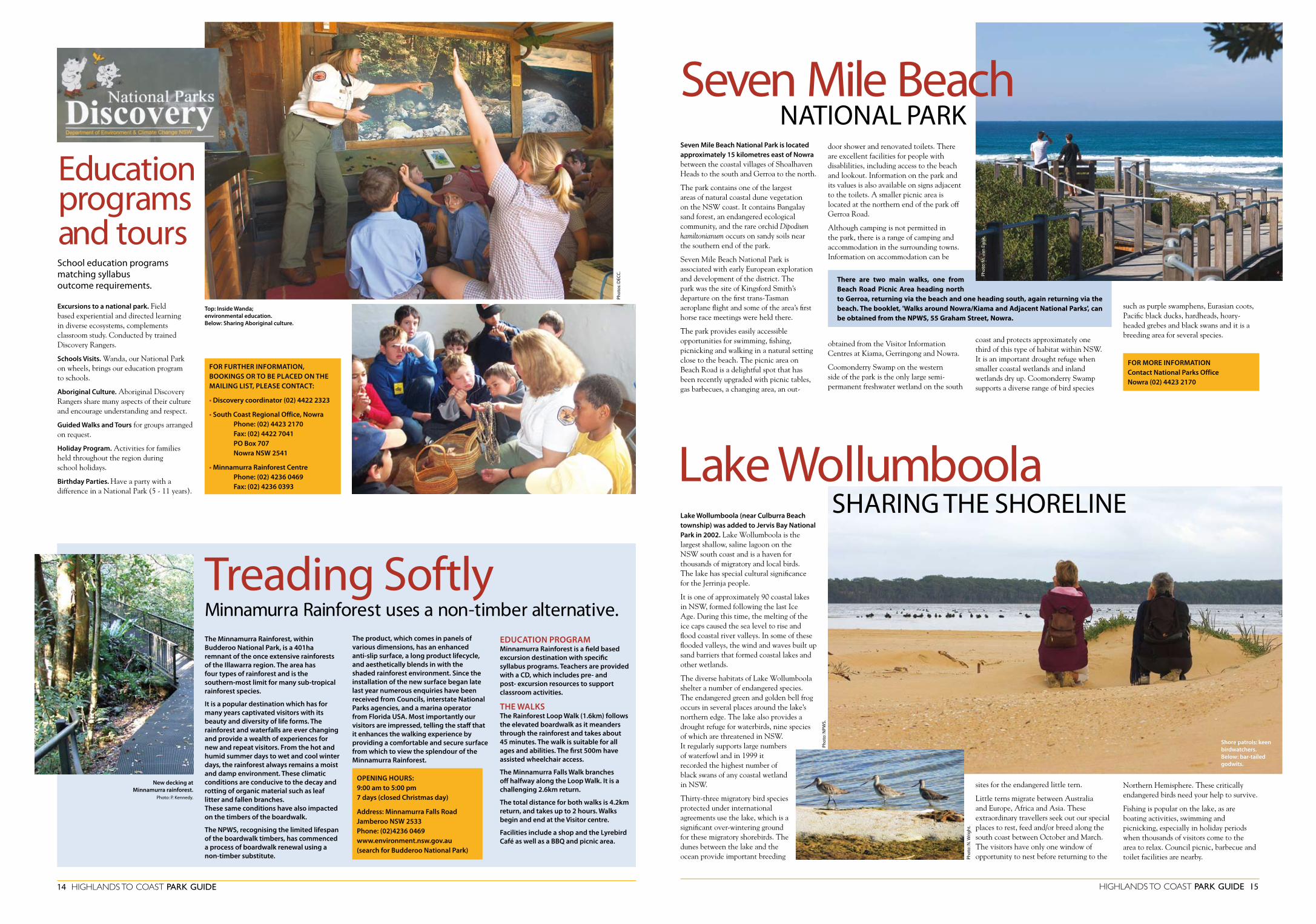
Seven Mile Beach National Park is located approximately 15 kilometres east of Nowra between the coastal villages of Shoalhaven Heads to the south and Gerroa to the north.
The park contains one of the largest areas of natural coastal dune vegetation on the NSW coast. It contains Bangalay sand forest, an endangered ecological community, and the rare orchid Dipodium hamiltonianum occurs on sandy soils near the southern end of the park.
Seven Mile Beach National Park is associated with early European exploration and development of the district. The park was the site of Kingsford Smith’s departure on the first trans-Tasman aeroplane flight and some of the area’s first horse race meetings were held there.
The park provides easily accessible opportunities for swimming, fishing, picnicking and walking in a natural setting close to the beach. The picnic area on Beach Road is a delightful spot that has been recently upgraded with picnic tables, gas barbecues, a changing area, an out-
FOR MORE INFORMATION Contact National Parks Office Nowra (02) 4423 2170
such as purple swamphens, Eurasian coots, Pacific black ducks, hardheads, hoary-headed grebes and black swans and it is a breeding area for several species.
door shower and renovated toilets. There are excellent facilities for people with disablilities, including access to the beach and lookout. Information on the park and its values is also available on signs adjacent to the toilets. A smaller picnic area is located at the northern end of the park off Gerroa Road.
Although camping is not permitted in the park, there is a range of camping and accommodation in the surrounding towns. Information on accommodation can be
obtained from the Visitor Information Centres at Kiama, Gerringong and Nowra.
Coomonderry Swamp on the western side of the park is the only large semi-permanent freshwater wetland on the south
coast and protects approximately one third of this type of habitat within NSW. It is an important drought refuge when smaller coastal wetlands and inland wetlands dry up. Coomonderry Swamp supports a diverse range of bird species
there are two main walks, one from Beach Road Picnic Area heading north to gerroa, returning via the beach and one heading south, again returning via the beach. the booklet, 'Walks around Nowra/kiama and Adjacent National Parks', can be obtained from the NPWS, 55 graham Street, Nowra.
Seven Mile Beach NaTioNal Park
Phot
o: M
. √an
Ew
ijk.
14 HigHlands to coast Park guide HigHlands to coast Park guide 15
Lake Wollumboola (near Culburra Beach township) was added to Jervis Bay National Park in 2002. Lake Wollumboola is the largest shallow, saline lagoon on the NSW south coast and is a haven for thousands of migratory and local birds. The lake has special cultural significance for the Jerrinja people.
It is one of approximately 90 coastal lakes in NSW, formed following the last Ice Age. During this time, the melting of the ice caps caused the sea level to rise and flood coastal river valleys. In some of these flooded valleys, the wind and waves built up sand barriers that formed coastal lakes and other wetlands.
The diverse habitats of Lake Wollumboola shelter a number of endangered species. The endangered green and golden bell frog occurs in several places around the lake’s northern edge. The lake also provides a drought refuge for waterbirds, nine species of which are threatened in NSW. It regularly supports large numbers of waterfowl and in 1999 it recorded the highest number of black swans of any coastal wetland in NSW.
Thirty-three migratory bird species protected under international agreements use the lake, which is a significant over-wintering ground for these migratory shorebirds. The dunes between the lake and the ocean provide important breeding
sites for the endangered little tern.
Little terns migrate between Australia and Europe, Africa and Asia. These extraordinary travellers seek out our special places to rest, feed and/or breed along the south coast between October and March. The visitors have only one window of opportunity to nest before returning to the
SHariNg THE SHorEliNE
Phot
o: N
. Wrig
ht.
lake Wollumboola
The Minnamurra Rainforest, within Budderoo National Park, is a 401ha remnant of the once extensive rainforests of the Illawarra region. The area has four types of rainforest and is the southern-most limit for many sub-tropical rainforest species.
It is a popular destination which has for many years captivated visitors with its beauty and diversity of life forms. The rainforest and waterfalls are ever changing and provide a wealth of experiences for new and repeat visitors. From the hot and humid summer days to wet and cool winter days, the rainforest always remains a moist and damp environment. These climatic conditions are conducive to the decay and rotting of organic material such as leaf litter and fallen branches. These same conditions have also impacted on the timbers of the boardwalk.
The NPWS, recognising the limited lifespan of the boardwalk timbers, has commenced a process of boardwalk renewal using a non-timber substitute.
The product, which comes in panels of various dimensions, has an enhanced anti-slip surface, a long product lifecycle, and aesthetically blends in with the shaded rainforest environment. Since the installation of the new surface began late last year numerous enquiries have been received from Councils, interstate National Parks agencies, and a marina operator from Florida USA. Most importantly our visitors are impressed, telling the staff that it enhances the walking experience by providing a comfortable and secure surface from which to view the splendour of the Minnamurra Rainforest.
Excursions to a national park. Field based experiential and directed learning in diverse ecosystems, complements classroom study. Conducted by trained Discovery Rangers.
Schools Visits. Wanda, our National Park on wheels, brings our education program to schools.
Aboriginal Culture. Aboriginal Discovery Rangers share many aspects of their culture and encourage understanding and respect.
Guided Walks and Tours for groups arranged on request.
Holiday Program. Activities for families held throughout the region during school holidays.
Birthday Parties. Have a party with a difference in a National Park (5 - 11 years).
School education programs matching syllabus outcome requirements.
Education programs and tours
EDUCATION PROGRAMMinnamurra Rainforest is a field based excursion destination with specific syllabus programs. Teachers are provided with a CD, which includes pre- and post- excursion resources to support classroom activities.
THE WALKSThe Rainforest Loop Walk (1.6km) follows the elevated boardwalk as it meanders through the rainforest and takes about 45 minutes. The walk is suitable for all ages and abilities. The first 500m have assisted wheelchair access.
The Minnamurra Falls Walk branches off halfway along the Loop Walk. It is a challenging 2.6km return.
The total distance for both walks is 4.2km return, and takes up to 2 hours. Walks begin and end at the Visitor centre.
Facilities include a shop and the Lyrebird Café as well as a BBQ and picnic area.
FOR FURTHER INFORMATION, BOOKINGS OR TO BE PLACED ON THE MAILING LIST, PLEASE CONTACT:
• Discovery coordinator (02) 4422 2323
• South Coast Regional Office, Nowra Phone: (02) 4423 2170 Fax: (02) 4422 7041 PO Box 707 Nowra NSW 2541
• Minnamurra Rainforest Centre Phone: (02) 4236 0469 Fax: (02) 4236 0393
Northern Hemisphere. These critically endangered birds need your help to survive.
Fishing is popular on the lake, as are boating activities, swimming and picnicking, especially in holiday periods when thousands of visitors come to the area to relax. Council picnic, barbecue and toilet facilities are nearby.
Treading SoftlyPh
otos
: DEC
C.
Shore patrols: keen birdwatchers. Below: bar-tailed godwits.
Phot
o: N
PWS.

FOR MORE INFORMATION on marine parks, zones and access points visit the NSW marine parks website at www.mpa.nsw.gov.au.Phone: 02 44 417752For information on Commonwealth waters, South Jervis Bay contact Booderee National Park 02 44 421006
Jervis Bay National Park (map ref. H7 page 10 and map page 17) protects part of the surrounding bushland and catchment areas of the bay as well as the bed of Lake Wollumboola. It preserves a flourishing diversity of plants and animals including some rare and threatened species such as the eastern bristlebird and powerful owl.
WHERE AND HOW?Jervis Bay National Park lies 200 km south of Sydney, just 20 km southeast of Nowra. The main visitor facilities are located at Greenfield Beach, Vincentia. There are also small picnic areas at Hammerhead Point and Red Point.
BUSHWALKING
Two linked tracks from Greenfield Beach provide 1–2 hour walks. The main track, White Sands Walk, also extends north (outside the national park) to Blenheim Beach and Plantation Point.
White Sands Walk (2 km return) begins at the boardwalk in the picnic area, crosses the creek and follows the coast southward. Interpretive signs highlight the importance of the bay.
If you wish to continue to Hyams Beach, go down the steps to Chinamans Beach,
16 HigHlands to coast Park guide
Jervis Bay a SPECial PlaCEClear blue water, white sandy beaches, eucalypt forests almost touching the sea, heathlands, dramatic sandstone cliffs, abundant marine life, brilliant birdlife . . . Jervis Bay is certainly a special place.
Listed as a threatened species this spectacular cockatoo is seen in pairs or flocks and is often mistaken for the yellow-tailed black cockatoo. It feeds on the seeds of casuarinas, which constitutes its principal food.
When feeding it is easy to approach, and when alarmed it moves, with a distinctive buoyant flight, to an adjacent tree. They nest in tree hollows and therefore depend on old growth trees closely linked to their feed tree, the casuarina, for their survival.
GLOSSy BLACK-COCKATOO (Calyptorhynchus lathami)
FOR MORE INFORMATION a brochure is available or log onto the NPWS web site: www.evironment.nsw.gov.au
HigHlands to coast Park guide 17
cross Duck Creek and walk through the forest behind the beach to Aster Street. From here you may choose to return along the beach — linking up with the track at Duck Creek. On your return to Greenfield Beach you can take the Scribbly Gum Track 50 m on your left past Duck Creek. The track is sloping with some steps.
The Scribbly gum Track starts at Greenfield Beach just behind the shelter shed. The track takes you through tall moist forest and scribbly gum woodland. It is a haven for small birds with wildflowers blooming all year. The Scribbly Gum Track joins White Sands Walk. Here you can either return to Greenfield Beach or extend your walk to Hyams Beach.
In recent decades there has been worldwide concern over the effects of human impact on marine ecosystems and their biodiversity. Many species have declined in size and abundance. Marine protected areas are one response to these concerns. Jervis Bay and Bateman Marine Parks are part of an integrated system of marine parks in NSW.
Habitats in marine park sanctuary zones must be complex, connected and large enough to preserve biodiversity. In the South Coast Region the zoning boundaries for marine parks have been developed using habitat and depth studies. Advances in geophysical imaging technology have allowed increased resolution and spatial coverage of the seabed. Recent mapping using these techniques in NSW marine parks has provided new information on the extent, distribution and structure of seabed habitats.
Habitat mapping undertaken in the last 5 years in the Jervis Bay Marine Park show that there are extensive sub-tidal rocky reefs throughout the marine park, with some complex reefs characterised by steep drop-offs, large boulders, caves and overhangs.
Recent research shows that as distance from the shore increases, the assemblage of reef species also changes. Intermediate (20-60m) and deep (+60m) reefs have much greater abundance and diversity than shallow reefs (0-20m). Less common species such as hogfish, butterfly perch and mosaic leatherjacket as well as several varieties of wrasse contribute to the diversity of deeper reefs in Jervis Bay. Trends from research monitoring the diversity of assemblages
on sub-tidal reefs in Jervis Bay also show a greater than 30% increase in abundance of larger reef fish, such as red morwong and wrasse, inside sanctuary zones since the establishment of the marine park.
Combining habitat maps with updated information on species distribution and other factors such as ocean currents will help improved assessment of the effectiveness of current zoning arrangements for protecting biodiversity.
The zoning of the new Bateman Marine Park was also established using habitat studies.
Marine parksSCiENCE SETS THE BouNDariES
Underwater exploration of Jervis Bay Marine Park. Photo: Paul Rebuck.
Following the introduction of legislation protecting marine mammals in NSW, the number of colonies of Australian (Arctocephalus pusillus doriferus) and New Zealand ( A.forsteri) Fur Seals has begun to increase along the east coast of Australia. One such colony exists at Steamers Head, south of Jervis Bay. Although Australian and New Zealand fur seals have their own habitat preferences it is believed that the terrain at Steamers Head is suited to both, and they happily coexist there.
During research conducted in Jervis Bay Marine Park over 100 seals were observed at that site during the peak haul-out period of September. These seals may travel
hundreds of kilometres to feed and can often be seen in the calmer waters of Jervis Bay during the warmer months where they will haul up onto various structures to rest. They usually prefer rock platforms or beaches, but have been known to sun themselves on the decks of moored yachts!
Anyone sighting a seal on the shore is advised to observe from a safe distance but avoid approaching as these animals can move very quickly, have powerful jaws and are capable of causing serious injury.
If an animal appears injured or dead then contact the National Parks and Wildlife Service on 4428 6300, or Jervis Bay Marine Park on 4441 7752.
SuN, SaND aND SEalSBatemans Marine Park (see map page 10) is a recent addition to the system of marine protected areas in NSW.
An outstanding feature of this marine park is the large expanses of rocky reef that support a variety of fish, invertebrates and seaweed. Islands such as the Tollgates and Montague and the surrounding waters provide breeding areas for many seabird species and for grey nurse sharks (an endangered species), pelagic fish, seals and penguins. The marine park also contains highly significant coastal lakes, lagoons and estuarine habitats, including mangrove and salt marsh.
The area is the traditional country of the Yuin people and contains many sites of historical and cultural significance. There is a long tradition of association with the south coast and continuing resource use.
The marine park is also particularly popular for holidays, beach activities, whale watching, diving, surfing, fishing and boating.
Batemans MariNE Park
19% of the park is set aside as Sanctuary Zones for long term conservation of biodiversity. Protected from harm, the many fascinating creatures will survive to be observed and enjoyed, now and by future generations.
43% of the park is Habitat Protection Zone in which commercial fishing is extremely limited. This makes ideal conditions for responsible recreational fishing and spearing.
Monitoring and research will continue to provide information for management decisions. The main objective of the research program is to assess the long term effectiveness of management strategies. It also aims to increase understanding of the marine environment, to detect unforeseen changes to the health of the marine ecosystem and to monitor activities.
Phot
o: M
Van
Ew
ijk.
Canoeing on Carama Creek, Currarong.
Phot
o: M
. Van
Ew
ijk.
Phot
o: M
. Van
Ew
ijk.

18 HigHlands to coast Park guide
MURRAMARANG ABORIGINAL AREAgrade: medium length: 1.5km return time: 2 hrs
Park at the Sandmine car park just north of the Racecourse Beach Caravan Park. Follow the sand track east to the beginning of the track. The area is a headland with a complex of Aboriginal middens that contain much evidence of cultural and scientifc value. Signs along the track provide information on this significant site.
HEADLAND WALK AT DEPOT BEACHgrade: steep length: 2km return time: 1.5hrs or 2hrs via rock platform
Walk through the camping ground to the fire station and turn right. Walk to the top of the hill. The track begins from the right, and crosses the headland (some steep spots here) to North Durras Beach. Return the same way or via the rock platform. Check tides.
HigHlands to coast Park guide 19
Murramarang National Park protects over 12,345 ha of coastal land between kioloa and Batemans Bay on the State’s south coast.
four offshore islands — Wasp, grasshopper, Dawsons and o’Hara — are also included in the park.
Depot Beach (map ref. F12 page 10), located in the heart of Murramarang National Park, is a great place for a camping holiday or a day’s relaxation, with its beautiful beach, great fishing, towering spotted gum forest, fascinating walks and abundant wildlife. Numerous eastern grey kangaroos are permanent residents — enjoy them from a distance and please don’t feed them.
BUSHWALKINGSeveral walking tracks provide a great way to explore the area. Behind the beach, majestic spotted gum forests with their understorey of spiky burrawangs are enchanting to explore. During the day you may see wallabies in the distance, blue tongue lizards basking in the sun and a variety of birds including parrots and honeyeaters. At night yellow-bellied gliders and greater gliders feed in the forest canopy. From Depot Beach you can walk along the beach to Pebbly Beach (approx. 1.5 hrs return) or Shelly Beach (10 mins) exploring the rock platforms and beaches. Banksias, coastal rosemary and lomandra grow on the exposed headlands, buffeted by salty sea winds. There may
Depot Beach. Below NPWS cabin accommo-dation at Depot Beach.
FOR INFORMATION on camping and cabin fees and bookings phone (02) 4478 6582.
be sea eagles soaring above, sooty oystercatchers along the shore or dolphins riding the waves out to sea. Depot Beach Rainforest Walk (30 min. loop) winds through cool forest which is dominated by lilly pillies, cabbage tree palms and coachwood. Lyrebirds and wonga pigeons forage in the undergrowth while eastern whipbirds and satin bowerbirds hide in the dense foliage. Signs explain many of the rainforest features along the way.
A very popular walk near Depot Beach is the Discovery Trail (see above), (refer map page 18).
FACILITIESDepot Beach Camping Area, set in an idyllic location, has a choice of 50 camp sites, some with power and several cabins in a bushland setting with views of the ocean. Some of these cabins are specifically designed to assist people with disabilities.
Facilities include: hot showers, flush toilets, a laundry, a toilet for the disabled and a baby change area. Barbecues, fireplaces and picnic tables are also provided.
In addition to camp fees, a day-use fee of $7.00 per vehicle applies in Murramarang National Park. Holders of a NSW National Parks Annual Pass are exempt from this fee.
NaTioNal ParkDEPOT BEACH TO SNAKE BAygrade: medium length: 12km return time: 4.5 hrs
Head north along Depot Beach to Pebbly Beach (but not at high tide), then follow the track from Pebbly Beach car park through the forest to Clear Point. From Clear Point head to Snake Bay. This remote part of the coast has isolated inlets, pebbly beaches and fascinating rock platforms.
Return the same way, or you can continue on to Pretty Beach via the coast or the Durras Mountain track.
DEPOT BEACH TO DURRAS MOUNTAINGrade: steep Length: 12km return Time: 5 hrs
Begin as for Snake Bay walk as far as Clear Point. Here, take the track west to Durras Mountain. Return the same way.
DURRAS DISCOVERy TRAIL grade: easy to medium length: 1.5km loop time: 45 mins (see lake walk below)
AND THE LAKE WALKgrade: easy length: 8kms return time: 3hrs
Take the Lake Road, off North Durras Road, to the car park. At the beginning of the walk is a rare rainforest remnant, of a type that is a classified endangered ecological community in NSW. The track divides after the bridge; go left for the Lake Walk or continue along the Durras Discovery Trail loop walk which has informative signs about the forest and the history of logging in the area. The Lake Walk ends at Mount Agony Road. Return the same way.
Murramarang National Park (map ref. F12, see page 10) offers visitors a wide range of activities including fishing, picnicking, bushwalking and nature study. The popular hinterland walk to Durras Mountain (283m), leads to views of the adjacent coastline and inland ranges.
People wanting to stay in and around Murramarang National Park can choose from a wide variety of camping and cabin accommodation. Information can be obtained from visitor information centres at Ulladulla and Nowra. Camping grounds operated by the National Parks and Wildlife Service within Murramarang National Park are listed below.
NPWS Pebbly Beach Camping Area has a great surfing beach and bushwalks within the national park. Facilities include a laundry, hot shower, flush toilets, barbecues and picnic tables. Campervans catered for, but not suitable for caravans.
Bookings for summer school holidays start on the October long weekend — phone (02) 4478 6023. Outside this time,
camping is on a first-come basis.
NPWS Depot Beach Camping Area and Cabins. See page 19 for details.
NPWS Pretty Beach Camping Area. See page 20 for details.
A park use fee applies in Murramarang National Park.
Murramarang Walks in Murramarang NaTioNal Park
Destination Depot
Phot
os: r
oger
Dun
n.
Phot
o: M
. Van
Ew
ijk.
Shell midden, Murramarang
Aboriginal Area. Photo: M. Van Ewijk.
Sun, sand and sea – relaxing at Pebbly Beach.
Phot
o: M
. van
Ew
ijk.
Phot
o: M
. Van
Ew
ijk.