high resolution sea surface roughness and wind speed with
TRANSCRIPT

1
Yongxiang Hu NASA Langley Research Center
Carl Weimer Ball Aerospace Corp.
High Resolution Sea Surface Roughness and Wind Speed with Space Lidar (CALIPSO)

CALIPSO Mission Overview
CALIPSO seeks to improve our understanding of the effects of aerosol and clouds on Earth’s climate
Launched: April 28, 2006
Operational Achievements: • Collected > 1.9 billion laser shots • Observations during day/night and for all seasons • Data publicly available
2

CALIPSO Lidar
3
• Surface Laser Spot Size: 70 m
• Vertical profiles of atmosphere
• 2 wavelength polarization sensitive lidar: 1064 nm, 532 nm (parallel and perpendicular)
Cloud-Aerosol Lidar with Orthogonal Polarization
(CALIOP)

CALIPSO Adds the Vertical Dimension

Ver(calProfilingofatmosphere,oceansurfaceandoceansub‐surface
0.3 degree

LidarBacksca@erMeasurementsofOceanSurface:Whatcanitdo
3/29/10
1. Direct measurements of mean surface roughness (transfer velocity estimates not sensitive to surfactants, fetch, …)
2. High spatial resolution (70 m) wind speed
3. Unambiguous separation of liquid / solid surface
4. Estimate of Bubbles
5. Excellent long term calibration stability

3/29/10 Low Wind Speed High Wind Speed
• Thesignal:oceansurfacelidarbacksca@ersignalfromspecularreflec(on
• Thephysics:higherwindroughersurfacelowerbacksca@er
(nadirpoin(nglaser;2%seasurfacereflec(onat1064nmwavelength;higherprobabilityoflaserbeamnormaltoseasurfaceatlowerwindspeed,thusmorechanceofspecularreturnbacktothelidarsystem)
SeasurfacewindspeedfromCALIPSO:Introduc(on

3/29/10
CALIPSO laser incident angle: 0.3 degree
near surface wind speed from CALIPSO lidar backscatter
Sea surface lidar backscatter (after a few corrections) = c / [<s2>]
Linear relation between wind speed and wave slope variance [<s2>] (Cox-Munk):
Lidar backscatter = c/(a+b*wind)

Es(ma(ngwindspeedfromCALIPSO:procedures
3/29/10
• Calibrating backscatter intensity
• Correcting for atmospheric two-way transmittance
• Correcting for backscatter from bubbles, water and particulates in water
• Estimating mean square wave slope =
0.02 / [4π corrected sea surface lidar backscatter]
Then we can estimate wind speed from mean square slope

Es(ma(ngwaveslopevariancefromCALIPSO:Correc(onforatmospherica@enua(on(molecularsca@er,
absorp(onandaerosol/cloudsca@ering)
3/29/10 89th AMS, Jan 10-16, 2009 Phoenix, AZ.
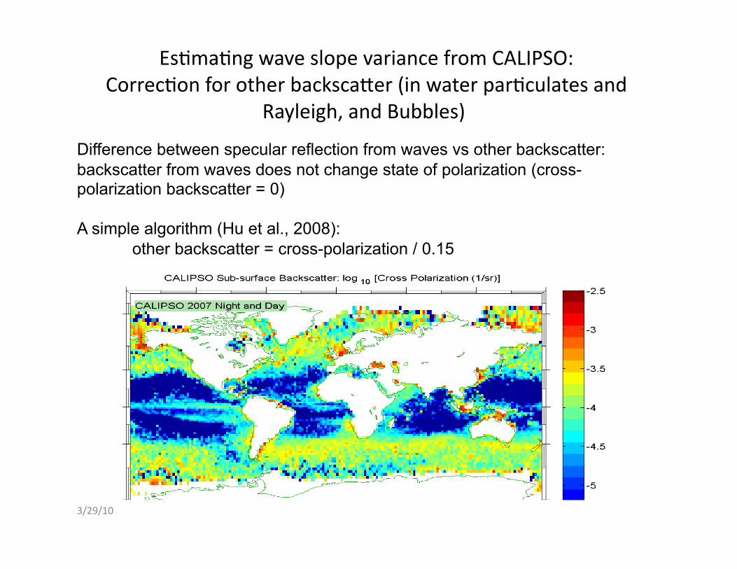
Es(ma(ngwaveslopevariancefromCALIPSO:Correc(onforotherbacksca@er(inwaterpar(culatesand
Rayleigh,andBubbles)
3/29/10
Difference between specular reflection from waves vs other backscatter: backscatter from waves does not change state of polarization (cross-polarization backscatter = 0)
A simple algorithm (Hu et al., 2008): other backscatter = cross-polarization / 0.15

3/29/10
Wave Slope Variance from CALIPSO
Wave slope variance = 0.02 / [4π * sea surface lidar backscatter]

Studyingwaveslopevariance–windspeedrela(onUsingcollocatedCALIPSOwaveslopeandAMSR‐Ewindmeasurements
3/29/10 89th AMS, Jan 10-16, 2009 Phoenix, AZ.
Advanced Microwave Scanning Radiometer - Earth Observing System (AMSR-E) is on Aqua satellite: 75 seconds ahead of CALIPSO
AMSR-E wind speed: derived from AMSR-E instrument (12 microwave channels, 6.92 to 89 GHz), 0.25 X 0.25 degree resolution

3/29/10
CALIPSOwaveslopevariancevsAMSR‐Ewindspeed
‘Wave Slope Variance’ = { a V0.5 (V < 7 m/s) c V + b (V > 7m/s)

3/29/10
ComparisonwithCALIPSOwindspeedfromAMSR‐E:Monthlymean
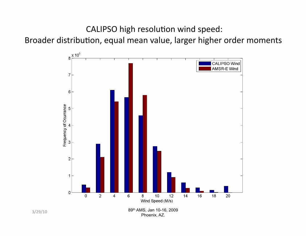
CALIPSOhighresolu(onwindspeed:Broaderdistribu(on,equalmeanvalue,largerhigherordermoments
3/29/10 89th AMS, Jan 10-16, 2009 Phoenix, AZ.

3/29/10
<V3>vswindspeedspa(alaveraging

Derivingturbulencetransfervelocityfromwindspeed:issuesthatleadtouncertainty
1. Nonlinearityofthegastransfervelocity–windspeedrela=on:makesithardtousespa(al/temporalaveragedwindspeeds:
(W12+W2
2)/2>[(W1+W2)/2]2
2.Seastatedependence:e.g.,forthesamewindspeed,gastransfervelocityreduceswhensurfactant(suchasdegradedplanktons)presents.
Tsai&Liu,2003:JGR,108,C4,DOI:10.1029/2000JC000740.

Air‐seagasexchangeimproveswithdirectmeansquarewaveslopemeasurements
(Jahneetal1984;Haraetal1995;Bocketal1999;Frewetal2004,…)Vertical gas transfer velocity correlates with wave slope variance better than wind speed
Frewetal,2004,JGR

Air-sea Gas Exchange
CO2 Uptake
= turbulence transport
* solubility * Δ(PCO2)
= f( Vn ) * solubility * Δ(Pco2)

3/29/10
Therela=onbetweenaandbofWeibulldistribu=onsfromAMSR‐E(blue)andCALIPSO(red).Rayleighdistribu=on(b=2)isagoodapproxima=onforwindspeedaround7m/swhenCALIPSOhighspa=alresolu=onwindspeedisused.
Shape Factor of Weibull Wind Distribution: CALIPSO (red) vs AMSR-E (blue)

1.Iden(fyingOpenOceanfromSnow/Iceusinglidar
depolariza(onra(o(δ)
Rel
ativ
e Fr
eque
ncy
Improving observations at high latitudes: spotting open water at 70 m footprint size

CALIPSOdepolariza=onmeasurements:Es=mateofBubbles
3/29/10

StableCalibra(on:GoodforLongTermTrendAnalysis
3/29/10

LidarBacksca@erMeasurementsofOceanSurface:Whatcanitdo
3/29/10
1. Direct measurements of mean surface roughness (transfer velocity estimates not sensitive to surfactants, fetch, …)
2. High spatial resolution (70 m) wind speed
3. Unambiguous separation of liquid / solid surface
4. Estimate of Bubbles
5. Excellent long term calibration stability

Summary
3/29/10
• Introduction of retrieving sea surface slope variance and wind speed from space-based lidar
• Lidar on CALIPSO provides the first global wind speed statistics at high spatial resolution (70m along-track), which can be useful for improvement of vertical turbulence exchange
• Three and half years of (June 2006 To Now) experimental CALIPSO wave slope variance and wind speed data will be available ([email protected], 757-864-9824)
• Looking for collaboration with anyone interested (validation, algorithm improvement, applications, concept studies for future lidar missions…)