heterogeneity in crustal structure across the southern ... · heterogeneity in crustal structure...
TRANSCRIPT
(2006) 18–28www.elsevier.com/locate/gr
Gondwana Research 10
Heterogeneity in crustal structure across the Southern Granulite Terrain(SGT): Inferences from an analysis of gravity and magnetic fields
in the Periyar plateau and adjoining areas
P. Ajayakumar a,1, P. John Kurian b, S. Rajendran a, M. Radhakrishna a,C.G. Nambiar a, T.M. Mahadevan c,⁎
a Department of Marine Geology and Geophysics, Cochin University of Science and Technology, Cochin-682016, Indiab National Centre for Antarctic and Ocean Research, Vasco-da-Gama, Goa- 403 804, India
c Sree Bagh, Ammankovil Road, Cochin-682035, India
Received 9 May 2005; accepted 24 November 2005Available online 9 May 2006
Abstract
The study region forms the western part of the Madurai block (southern block) and shares several lithological characteristics of the Proterozoicexhumed South Indian Granulite Terrain (SGT). The crustal structure of the area has been derived from gravity data, constrained partly byaeromagnetic data. The Bouguer anomaly map of the region prepared based on detailed gravity observations shows a number of features (i) thePeriyar lineament separates two distinctly different gravity fields, one, a high gravity gradient tending to be positive towards the coast in southwest and significant gravity lows ranging from −85 to as low as −150 mGal in the NE covering a large part of the Periyar plateau (ii) within thebroad gravity low, three localised circular anomalies of considerable amplitude occur in the region of Munnar granite. A magnetic low region inthe central part coincides with the area of retrogressed charnockites and the major lineaments suggestive of a genetic link and considerabledownward extent. The crustal models indicate that the upper layer containing exhumed lower crustal rocks (2.76 gm/cc) is almost homogeneous,most part of the gravity field resulting from variations in intracrustal layers of decharnockitised hornblendic gneisses and granite bodies. Below it,a denser layer (2.85 gm/cc) of unknown composition exists with Moho depth ranging from 36 to 41 km. The structure below the region iscompared with that of two other segments of the SGT from which it differs markedly. The Wynad plateau forming the western part of the NorthernBlock of the SGT is characterised by a heterogeneity due to the presence of contrasting crustal blocks on either side of the Bavali shear zone,possibly a westward extension of the Moyar shear zone and presence of high density material in the mid-to-lower crustal portions. The crust belowthe Kuppam–Palani transect has a distinctive four-layer structure with a mid-crustal low density layer. The differences in crustal structure areconsistent with the different tectonic settings of the three regions discussed in the paper. It is suggested that the crustal structure below theKuppam–Palani transect corridor is not representative of the SGT as a whole, an aspect of great relevance to intra-continental comparisons andtrans-continental reconstructions of continent configurations of the Gondwanaland.© 2006 International Association for Gondwana Research. Published by Elsevier B.V. All rights reserved.
Keywords: Gravity anomalies; Crustal structure; Periyar plateau; Southern Granulite Terrain; Proterozoic
1. Introduction
The southern Indian Shield comprises the Archaean granite–greenstone terrains of Dharwar Craton in the north and thehigh-grade Southern Granulite Terrain (SGT) in the south. The
⁎ Corresponding author. Tel.: +91 4842352379.E-mail address: [email protected] (T.M. Mahadevan).
1 Present address: EER Division, Central Water and Power Research Station,Pune-411024, India.
1342-937X/$ - see front matter © 2006 International Association for Gondwana Rdoi:10.1016/j.gr.2005.11.011
SGT is separated from the Dharwar Craton by the orthopyr-oxene isograd identified by Fermor (1936), which essentiallyseparates the charnockitic and non-charnockitic terrains in theshield. Fermor initially suspected a fault along what has cometo be known as the Fermor line. There, however, exists anarrow transition zone (rather than a linear boundary) alongwhich the low-grade greenstone–granite domain transforms tohigh-grade granulite facies rocks (Swaminath et al., 1976). Thesouthern Indian Shield, therefore, provides an oblique cross-section across the continental crust (Fountain and Salisbury,
esearch. Published by Elsevier B.V. All rights reserved.

19P. Ajayakumar et al. / Gondwana Research 10 (2006) 18–28
1981). The SGT south of the transition zone is traversed by aset of major faults or shear zones, the most prominent amongthem are the shear systems of Moyar–Bhavani, Palghat–Cauvery and the Achankovil–Thenmalai (Fig. 1). Notably, theMoyar shear zone takes a NW–SE trend further west into theWynad plateau and is named as the Bavali shear zone (Nair etal., 1976).
Landsat imagery study in this region by Drury and Holt(1980) revealed the regional nature of the major shear zones.The high-grade domain north of the Palghat–Cauvery shearzone (PCSZ) is referred to as the “northern block” and thedomain to the south of the PCSZ, the “southern block”. TheAchankovil–Thenmalai shear zone divides the “southernblock” into the northern Madurai block and the southern Kerala
Fig. 1. Simplified geological map of South India (modified after Raith et al., 1983, inPRL: Periyar lineament; IML: Idamalayar lineament; KRL: Kerala lineament; JHE: Jlineament; DRZ: Dharmapuri rift zone. Marked as rectangles represent 1. Central Kearea. Also shown are the profiles selected for modelling as AA′ and BB′.
block (also called the Trivandrum block). Both the high-gradedomains in the north and south have witnessed several phases ofultrabasic, basic, granitic and alkaline magmatism throughmainly the Proterozoic (2500–550 Ma).
It is generally held that the southern Indian Shield is acomposite continental segment, formed by the accretion ofvarious crustal blocks during the mid-Archaean to Neoproter-ozoic (Radhakrishna, 1989; Harris et al., 1994; Jayananda andPeucat, 1996). However a unitary model of one continentdissected by steep faults has also been recently proposed(Mahadevan, 1998), consistent with earlier concepts of Fermor(1936). Based on geochronology and isotope data different ageprovinces with distinct precrustal histories are proposed withinthe composite unit of southern Indian Shield (Harris et al., 1994;
corporating recent data). Also shown is the Kuppam–Palani (K–P) geotransect.avadi Hills East fault; MPL: Mettur–Palakkodu shear lineament; KBL: Kambamrala (present study area), 2. Wynadu plateau and 3. Kuppam–Palani geotransect

20 P. Ajayakumar et al. / Gondwana Research 10 (2006) 18–28
Bartlett et al., 1995; Jayananda et al., 1995; Bhaskar Rao et al.,2003; Santosh et al., 2003; Cenki et al., 2004). Thus, for theDharwar Craton the crust formation is considered to beArchaean (3.58–2.50 Ga), while the exhumed high-graderegion to the south continued to evolve during late Archaeanto Neoproterozoic. The Madurai and Trivandrum blockswitnessed a dominant impact of the Pan-African tectono-thermal events, manifested in the emplacement of many alkalineand calc-alkaline granitic intrusives (Santosh, 1989; Santosh etal., 2003).
An important question that needs to be addressed is whetherthe deep continental structure across several segments of theSouth Indian Shield reflects the diverse geological settingsbrought out by the earlier studies. Such an attempt is made inthis paper based on interpretation of geophysical data. In thepresent study, we undertake a detailed gravity investigationconstrained with aeromagnetic anomalies in the Periyar plateauand the surrounding regions of the SGT covering parts of Keralaand Tamilnadu so as to delineate the crustal structure in the
Fig. 2. Geological map of the study area (after GSI, 1995). Lines AA′ and BB′
region. The area falls within the Madurai block of the SGT andis bounded by the Palghat–Cauvery shear zone in the north andthe Achankovil–Thenmalai shear zone in the south. The resultswill be compared with the deep continental structure belowadjacent regions of the SGT. The regions selected are (i) theWynad plateau forming the western part of the Northern Blockand (ii) the Kuppam–Palani geotransect corridor that runs alongthe central part of the Northern Block, along the a ProterozoicDharmapuri intra-continental rift zone and the Palghat–Cauveryshear zone.
2. Regional geology
The geological map of the Periyar plateau and the surr-ounding areas is presented in Fig. 2. It is based on the revisedmaps of Kerala and Tamilnadu prepared by the GeologicalSurvey of India (GSI, 1995). The main geological format-ions in the area comprise members of charnockite suite withbands of leptynites, garnet-free mafic granulites, migmatitic
show the location of the regional gravity profiles considered for modelling.

Fig. 3. Bouguer anomaly map of the Periyar plateau and the adjoining regions. Contour interval 5 mGal (PPGL: Periyar plateau gravity low). The location of profilesselected for modelling are shown as lines AA′ and BB′. The gravity data distribution is shown in the inset.
21P. Ajayakumar et al. / Gondwana Research 10 (2006) 18–28
gneisses, garnet cordierite gneisses, garnet cordierite sillima-nite gneisses and granitoids. The charnockitic rocks are pos-sibly of Archaean and Proterozoic age. The charnockiticbasement rocks have been transformed along major line-aments into hornblende–biotite gneisses (Mahadevan, 1964)possibly during the Pan-African tectono-thermal event, cul-minating in the emplacement of granite rocks, dated 740±30and 550 Ma (Santosh et al., 1989, 2003). Major dykes run-ning for a few tens of kilometres closely related to the Keralalineament and in a NW–SE to NNW–SSE direction, somewhatparallel to the coast are prevalent in the area (Fig. 2). They aremostly late Mesozoic in age and include fresh dolerites andsubalkalic Fe-rich quartz tholeiites (Radhakrishna et al., 1986,1994).
The lineaments of the study region could be classified basedon their orientation as 1) NW–SE to WNW–ESE, 2) NNW–SSE to N–S and 3) ENE–WSW trending lineaments. One of themost prominent lineaments in study area is the NW–SEtrending Periyar lineament, extending over a distance of about90 km from NE of Angamali to SE of Udumbanshola (Fig. 2).The lineament is joined by the Idamalayar lineament, strikingNNW–SSE, east of Kothamangalam. The Periyar lineament isoften been considered as an active tectonic feature and theseismicity in the area is suspected to be due to strike-slipmovements along this lineament. However, their associationwith major dykes led to the inference that the lineaments may bedue to tensional fractures related to the major distensionalfaulting of the West Coast (Karunakaran and Mahadevan,1971). The third major lineament, the Kerala lineament too hassuch associated dyke emplacement.
Perhaps the most significant feature of the Precambrianevolution is the exhumation of the high-grade rocks (charnock-ites and khondalites) from depths of 20–30 kb (30–45 km)culminating in the emplacement of the granitic rocks of Pan-African age (∼550 Ma). The exhumation may have beendifferential resulting in major shear zones (Mahadevan, 2003a).
3. Gravity data and anomaly map
3.1. Data
In order to understand the nature of crust and the attendanttectonics, we carried out detailed gravity surveys in the Periyarplateau and the adjoining areas. A Lacoste–Romberg (Model G)gravimeter with an accuracy of 0.01 mGal was used for the dataacquisition and nearly 1200 gravity measurements were madecovering all possible motorable roads at an average stationspacing of 1–2 km in the region. The measurements were madeutilising already available base stations and by establishingadditional secondary base stations. The elevation data has beenconsidered from spot heights, benchmarks and toposheets. The1930 international gravity formula and the surface rock densityof 2.67 gm/cc were used for the purpose of gravity data re-duction. The error in the elevation could be of the order of 3–5 m and considering other factors such as instrumental limita-tions, the maximum error in the gravity data may be about1.5 mGal. Apart from the gravity map prepared from this data,the available aeromagnetic and analytic signal maps pertainingto the study region have also been considered as an additionalconstraint. The density and magnetic susceptibility of various

22 P. Ajayakumar et al. / Gondwana Research 10 (2006) 18–28
rock types of the region were determined by collecting a goodnumber of rock samples.
3.2. Gravity anomaly map
The Bouguer anomaly map prepared for the study region at acontour interval of 5 mGal is shown in Fig. 3. The Bouguercontour map shows good correlation with the surface geologyand the minor geological structures of the area. The anomalymap suggests that the gravity field in the NE of Periyar lineamentis distinctly different from that of SW part. It separates a stronggravity gradient tending to be positive towards the coast from thesignificant gravity lows ranging from −85 to as low as−150 mGal covering a larger part in the Periyar plateau. Thepresence of granitic plutons is brought out by domical low in theBouguer anomaly map over Periyar plateau, the Munnar granitemass being characterised by three gravity lows (PPGL-1, PPGL-2 and PPGL-3). However, two strong gradient zones have beenobserved on the Bouguer anomaly map (LM1and LM2). Whilethe LM1 coincides with the earlier identified Kerala lineament,LM2 is not so far been recognised and is named here asKottayam–Kodungallur lineament. The Bouguer gravity fielddoes not appear to be sensitive to lineaments due to lack ofdistinctive density contrast on either side of the lineaments. Theisostatic anomalies in the region under study vary from −20 to−80 mGal (NGRI, 1978). Such variations in the isostaticanomalies suggest lateral inhomogeneities in the crustal massesor changes in crust–mantle interface.
Fig. 4. A generalized map depicting gravity and magnetic (both total field and analytictext. PPGL-1, -2 and -3 are small gravity low closures in the Periyar plateau.
4. Geological inferences from gravity and magneticanomalies
Recently Harikumar et al., (2000) and Rajaram and Anand(2003) generated an aeromagnetic anomaly and the analyticsignal maps of the peninsular shield region. The colour-codedimages of the aeromagnetic and analytic signal maps preparedby them were provided to us for the purpose of correlation.These maps along with the gravity map have been used forqualitative analysis. The significant trends and patternsobserved from these maps have been depicted in Fig. 4 so asto understand the surface and subsurface geologicalcharacteristics.
In this region, two distinct sub-provinces of magnetic highsmay be distinguished (i) Trichur–Udumbanshola province inthe NE and (ii) the Trichur–Ernakulam–Kottayam province inthe SW (Fig. 4). A prominent NW–SE trending belt ofmagnetic low separates the two provinces of magnetic high.Interestingly these low magnetic belts encompass a large areaof hornblende gneisses (retrograded charnockites), mapped inthe geological map of the region. The boundary of thesemagnetic high and low provinces on either side correlate withthe Periyar and the Kottayam–Angamali lineaments. Theanalytic signal map reveals that the block of outcroppinghornblende gneisses in the NE is underlain by strong magneticsources, which suggests the presence of pristine charnockites atdepth. The Periyar and the Kottayam–Angamali lineamentsfind expression in the analytic signal map also. It may therefore
signal) anomaly trends and patterns in the study area. Details are discussed in the

23P. Ajayakumar et al. / Gondwana Research 10 (2006) 18–28
be inferred that these lineaments are boundaries (edges) ofcrustal segments with distinct magnetic characteristics. Further,the gravity anomaly map reveals that the Kottayam–Angamalilineament coincides with a gravity gradient and the Periyarlineament separates two distinctly different gravity fields oneither side. The presence of large retrograded charnockitesin the area between these two lineaments indicates the pos-sibility of genetic linkage between the retrogression and thelineament. This further indicates that both Periyar andKottayam–Angamali lineaments could be deep seated features,where the latter may have special status as it separates a
Fig. 5. Interpreted crustal models along profiles
distinctive magnetic field along the coastal tract from that of theinterior.
5. Gravity modelling and deep structure
In order to obtain the crustal structure in the region, two-dimensional gravity modelling was carried out along a number ofprofiles using the SAKI program of USGS (Webring, 1985). Tworepresentative selected profiles AA′ and BB′ are presented here.Considering the average densities for the surface rocks and themid-to-lower crustal exhumation in the SGT, a two-layer crustal
AA' and BB' in the Periyar plateau region.
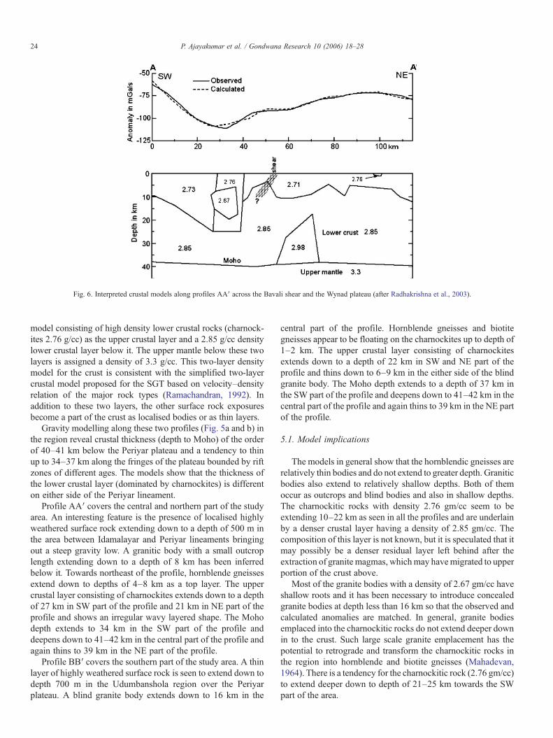
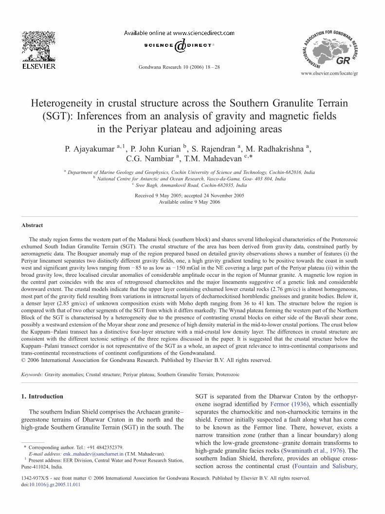
Fig. 6. Interpreted crustal models along profiles AA′ across the Bavali shear and the Wynad plateau (after Radhakrishna et al., 2003).
24 P. Ajayakumar et al. / Gondwana Research 10 (2006) 18–28
model consisting of high density lower crustal rocks (charnock-ites 2.76 g/cc) as the upper crustal layer and a 2.85 g/cc densitylower crustal layer below it. The upper mantle below these twolayers is assigned a density of 3.3 g/cc. This two-layer densitymodel for the crust is consistent with the simplified two-layercrustal model proposed for the SGT based on velocity–densityrelation of the major rock types (Ramachandran, 1992). Inaddition to these two layers, the other surface rock exposuresbecome a part of the crust as localised bodies or as thin layers.
Gravity modelling along these two profiles (Fig. 5a and b) inthe region reveal crustal thickness (depth to Moho) of the orderof 40–41 km below the Periyar plateau and a tendency to thinup to 34–37 km along the fringes of the plateau bounded by riftzones of different ages. The models show that the thickness ofthe lower crustal layer (dominated by charnockites) is differenton either side of the Periyar lineament.
Profile AA′ covers the central and northern part of the studyarea. An interesting feature is the presence of localised highlyweathered surface rock extending down to a depth of 500 m inthe area between Idamalayar and Periyar lineaments bringingout a steep gravity low. A granitic body with a small outcroplength extending down to a depth of 8 km has been inferredbelow it. Towards northeast of the profile, hornblende gneissesextend down to depths of 4–8 km as a top layer. The uppercrustal layer consisting of charnockites extends down to a depthof 27 km in SW part of the profile and 21 km in NE part of theprofile and shows an irregular wavy layered shape. The Mohodepth extends to 34 km in the SW part of the profile anddeepens down to 41–42 km in the central part of the profile andagain thins to 39 km in the NE part of the profile.
Profile BB′ covers the southern part of the study area. A thinlayer of highly weathered surface rock is seen to extend down todepth 700 m in the Udumbanshola region over the Periyarplateau. A blind granite body extends down to 16 km in the
central part of the profile. Hornblende gneisses and biotitegneisses appear to be floating on the charnockites up to depth of1–2 km. The upper crustal layer consisting of charnockitesextends down to a depth of 22 km in SW and NE part of theprofile and thins down to 6–9 km in the either side of the blindgranite body. The Moho depth extends to a depth of 37 km inthe SW part of the profile and deepens down to 41–42 km in thecentral part of the profile and again thins to 39 km in the NE partof the profile.
5.1. Model implications
The models in general show that the hornblendic gneisses arerelatively thin bodies and do not extend to greater depth. Graniticbodies also extend to relatively shallow depths. Both of themoccur as outcrops and blind bodies and also in shallow depths.The charnockitic rocks with density 2.76 gm/cc seem to beextending 10–22 km as seen in all the profiles and are underlainby a denser crustal layer having a density of 2.85 gm/cc. Thecomposition of this layer is not known, but it is speculated that itmay possibly be a denser residual layer left behind after theextraction of granite magmas, whichmay havemigrated to upperportion of the crust above.
Most of the granite bodies with a density of 2.67 gm/cc haveshallow roots and it has been necessary to introduce concealedgranite bodies at depth less than 16 km so that the observed andcalculated anomalies are matched. In general, granite bodiesemplaced into the charnockitic rocks do not extend deeper downin to the crust. Such large scale granite emplacement has thepotential to retrograde and transform the charnockitic rocks inthe region into hornblende and biotite gneisses (Mahadevan,1964). There is a tendency for the charnockitic rock (2.76 gm/cc)to extend deeper down to depth of 21–25 km towards the SWpart of the area.

25P. Ajayakumar et al. / Gondwana Research 10 (2006) 18–28
6. Comparison with other areas of SGT
Detailed gravity derived crustal models are available forother areas of SGT that include the Bavali shear and the WynadSchist belt of the Wynad plateau region (Radhakrishna et al.,2003) and the Kuppam–Palani geotransect region (Singh et al.,2003). It is, therefore, relevant to compare the crustalconfiguration in the present study region with these areas inorder to understand the nature of crust in different parts of theSGT.
6.1. Wynad Schist belt and adjoining areas
Gravity modelling was carried out along several profilesacross the Bavali shear zone (Radhakrishna et al., 2003), whichhas thrown light on the nature of crust below the Wynad Schistbelt and the adjoining area. A representative gravity model hasbeen selected for comparison. The crustal model (Fig. 6) pointsthe presence of a crust around 38 km with a high density mass of2.98 g/cc at its base.
The schist–gneiss complex of the Kannur/Manathavadyextends for about 150 km in an WNW–ESE direction with anapproximate width of 10–20 km. The NW–SE trending Bavalishear with a length of 100 km passes through the centre of thearea (Nair et al., 1976). The Bavali shear possibly may be awestward extension of the Moyar shear zone. The adjoiningregions constitute charnockites and their retrograded productsas the predominant rock type. The area is also characterised bythe occurrence of several igneous plutons of felsic and maficcomposition emplaced within or close to the gneisses andschists.
The models presented in Radhakrishna et al., (2003) exhibita plane separating two contrasting crustal densities close to theBavali shear zone. However, crustal model from the Wynadplateau region (Fig. 6), the shear zone appears to be lessprominent.
6.2. Kuppam–Palani geotransect profile
The Kuppam–Palani geotransect encompasses a largesection of continental crust that displays a transition fromgranite–greestone terrain in the north through high-grade gneissand granulites in the south. The Kuppam–Jalakandapuramsegment of the Kuppam–Palani transect runs along the NEtrending Proterozoic Dharmapuri intra-continental rift zone(DRZ) and the Jalakandapuram (Kolattur)–Palani segmenttransects across the E–W running Palghat–Cauvery shear zone(PCSZ) (Gopalakrishnan, 1996; Mahadevan, 2003b). Four eastwest trending shear zones dissect the corridor, from north tosouth and these are Moyar–Bhavani shear zone, the Chenni-malai–Moyar shear zone, Dharmapuri shear zone andDevathur–Kallimandyam shear zone (Chetty et al., 2003).The transect is also characterised by the occurrence of severalalkaline complexes like Savattur, Yelagiri, Samalpatti, Pakka-nadu and Sivamalai and granite plutons such as Trihankode,Karamadai, etc. One of the significant aspects of this transect isthat it cut across the major structure in the SGT, namely the
Palghat–Cauvery shear zone, which is considered as a majorductile shear (Drury and Holt, 1980), collision zone (Gopa-lakrishnan, 1996), crustal suture (Radhakrishna, 1989), andreactivated rift (Mahadevan, 2003b).
Detailed gravity modelling along the transect, where, wellcontrolled seismic refraction–reflection profile from Kuppam toPalani is available (Reddy et al., 2003) has been undertaken bySingh et al.(2003). Their models along Kuppam–Kumarapa-layam and Kolattur–Palani segments are presented here forcomparison (Fig. 7). The crustal models reveal a four-layeredcrustal configuration with Moho varying from 41 km beneathKuppam to 43–44 km further south. The maximum thickness ofthe crust is 46 km below Kambainallur. The models also in-dicate the presence of a low density mid-crustal layer all alongthe transect. According to them the intense crust–mantleinteraction and flushing out of fluids has led to the presenceof mid-crustal low density layer.
7. Tectonic setting and deep crustal structure
The three regions referred to above, namely the Periyarplateau, the Wynad plateau and the Kuppam–Palani transectcorridors, are an integral part of the southern Indian exhumedhigh-grade domain (the SGT) but are characterised by dis-tinctive tectonic settings. The Kuppam–Palani geotransect islocated along the central part of the SGT cutting across themajor E–W structural trends and shears like the Dharmapuri riftzone and the Palghat–Cauvery shear zone and the rocksexposed are essentially unclassified gneisses. On the other hand,the Periyar plateau is dominated by massive charnockites and isdevoid of major shear zones within it, though major shears markits the northern and southern boundaries. The Wynad plateaulies close to the gneiss–granulite transition zone and is cutacross by the Bavali shear passing through the middle of thearea.
A comparison of the crustal structure in these three differentparts of the SGT is worth attempting, as these regions aredistinctly different from each other in terms of their tectonicsetting and nature of the crust. The crustal structure is char-acterised by an almost homogeneous thickened crust below thePeriyar plateau with most part of the gravity field resulting fromvariations in the intracrustal layers/bodies of hornblendicgneisses and granites. On the other hand, in the Wynad region,the crust is rendered highly heterogeneous by the presence ofcontrasting crustal blocks on either side of the Bavali shear inshallow part and the presence of high density material in themid-to-lower crustal portions (Radhakrishna et al., 2003). Thecrust below the central part of the SGT, along Kuppam–Palanitransect corridor running along the Dharmapuri palaeo-rift hasthe distinction of the presence of a 7–15 km thick mid-crustallow density layer evolved during the emplacement of largevolumes of granitic rocks and alkaline plutons and a very highlythickened crust (41–45 km) (Singh et al., 2003). The inherentambiguity in the gravity models obtained for the Periyar andWynad plateau areas may partly be due to the absence ofseismic data control. However, the presence of a high densitymaterial in the lower part of the crust in the Wynad region and
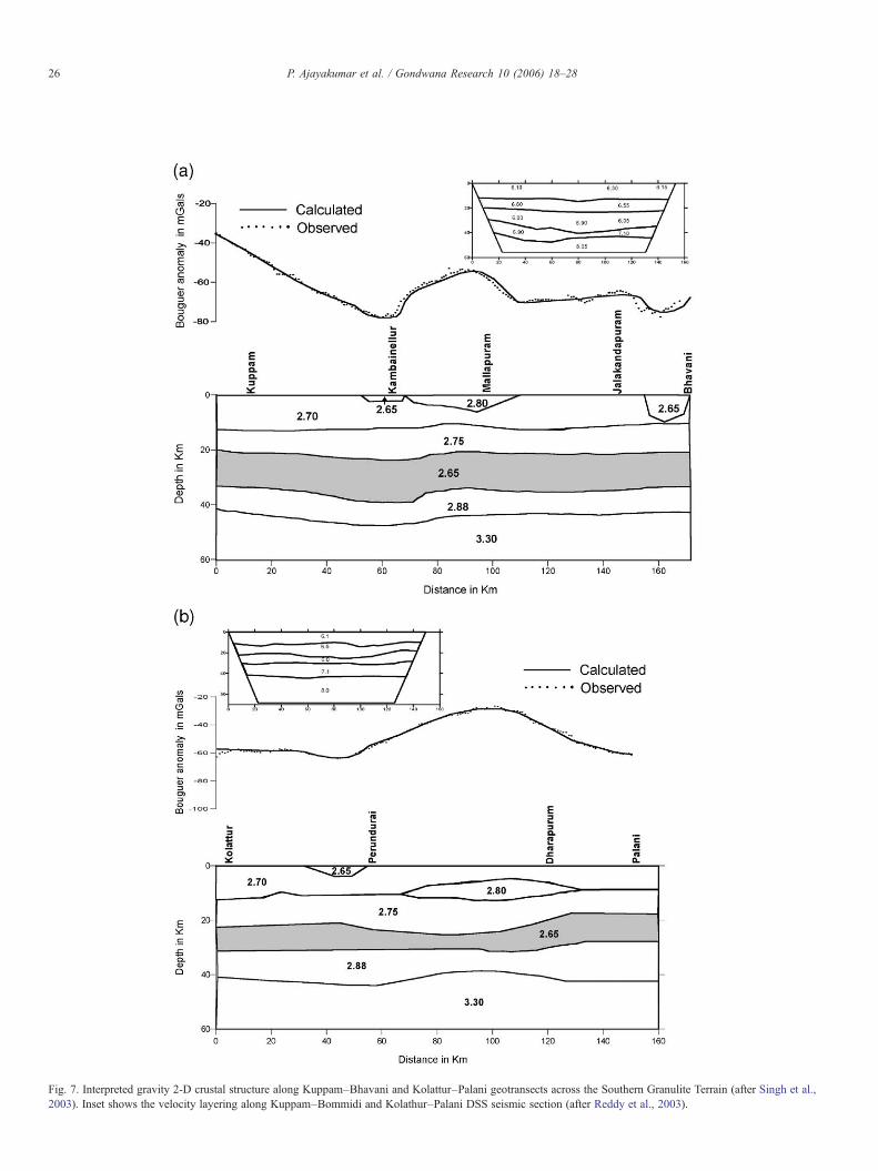
Fig. 7. Interpreted gravity 2-D crustal structure along Kuppam–Bhavani and Kolattur–Palani geotransects across the Southern Granulite Terrain (after Singh et al.,2003). Inset shows the velocity layering along Kuppam–Bommidi and Kolathur–Palani DSS seismic section (after Reddy et al., 2003).
26 P. Ajayakumar et al. / Gondwana Research 10 (2006) 18–28
27P. Ajayakumar et al. / Gondwana Research 10 (2006) 18–28
highly variable mid-crustal interface and the granite emplace-ments in the Periyar plateau region have been necessitatedconsidering the amplitude and wavelength of anomalies.
8. Conclusions
The results presented in this paper underline the fact that theSGT, though comprising largely of exhumed lower crust of theIndian Shield in the Proterozoic, comprises segments, whichhave been affected differentially by tectonic and magmaticevents of both the Proterozoic and Phanerozoic that havebrought about distinctive continental structure below them. Thecontinental crustal structure below the centrally placedKuppam–Palani transect, though well constrained by seismicprofiling, may not still be extended to the whole of the SGT. Thegravity models presented in this paper need to be further refinedby incorporating seismic data, but may not, even then, portraythe same picture as is obtained in the Kuppan–Palani transect.Thus it is suggested that the crustal structure below Kuppam–Palani transect corridor is not representative of the SGT as awhole. This aspect is particularly relevant when comparisonsare made of the deep continental structure in the inter-cratonicblocks and across the continental boundaries, as for example,when modelling the continental reconstructions across theconstituents of the Gondwanaland.
Acknowledgements
The authors thank Dr. Mita Rajaram, Indian Institute ofGeomagnetism, Mumbai for providing the colour-codedaeromagnetic and analytic signal maps of the study region.Part of the gravity data in the study region was acquired from aDST sponsored project (ESS/5(12)/WB/proj./96). The authorsPJK and PA thank the Director, NCAOR, Goa for his supportduring this work. Critical comments and suggestions from Dr.C.Subrahmanyam and an anonymous reviewer have helpedgreatly to improve the quality of the manuscript.
References
Bartlett, J.M., Harris, N.B.W., Hawkesworth, C.J., Santosh, M., 1995. Newisotope constraints on the crustal evolution of South India and Pan-Africangranulite metamorphism. Mem. Geol. Soc. India 34, 391–397.
Bhaskar Rao, Y.J., Janardhan, A.S., Kumar, T., Narayana, B.L., Dayal, A.M.,Taylor, P.N., Chetty, T.R.K., 2003. Sm–Nd model ages and Rb–Sr isotropicsystematics of charnockites and gneisses across the Cauvery shear zone ofsouthern India: implications for the Archean–Neoproterozoic terrainboundary in the Southern Granulite Terrain. In: Ramakrishnan, M. (Ed.),In Tectonics of Southern Granulite Terrain: Kuppam–Palani GeotransectGeol. Soc. of India, Mem., vol. 50.
Cenki, B., Braun, I., Broker, M., 2004. Evolution of the continental crust in thePan-African mobile belt of southern most India: evidence from Nd isotopemapping combined with U–Pb and Rb–Sr geochronology. Precambrian Res.134, 1–20.
Chetty, T.R.K., Bhaskar Rao, Y.J., Narayana, B.L., 2003. A structural cross-section along Krishnagiri–Palani corridor, Southern Granulite Terrain ofIndia. Mem. Geol. Soc. India 50, 255–277.
Drury, S.A., Holt, R.W., 1980. The tectonic framework of the South Indiancraton: a reconnaissance involving LANDSAT imagery. Tectonophysics 65,T1–T15.
Fermor, L.L., 1936. An attempt at the correlation of the ancient schistoseformations of Peninsular India. Mem. Geol. Surv. India 70, 1–52.
Fountain, D.M., Salisbury, M.H., 1981. Exposed cross-sections through thecontinental crust; implications for crustal structure, petrology and evolution.Earth Planet. Sci. Lett. 56, 263–277.
Gopalakrishnan, K., 1996. An overview of Southern Granulite Terrain, India—constraints in reconstruction of Precambrian assembly of Gondwanaland.Gondwana Nine, vol. 2. Oxford and IBH, New Delhi, pp. 1003–1026.
GSI (Geological Survey of India), 1995. Geological and Mineral Map of Keralaand Tamilnadu.
Harikumar, P., Rajaram, M., Balakrishnan, T.S., 2000. Aeromagnetic study of Pe-ninsular India. Proc. Indian Acad. Sci., A Earth Planet. Sci. 109 (3), 381–391.
Harris, N.B.W., Santosh, M., Taylor, P.N., 1994. Crustal evolution in SouthIndia: constraints from Nd isotopes. J. Geol. 102, 139–150.
Jayananda, M., Peucat, J.J., 1996. Geochronological framework of southernIndia. Gondwana Res., Mem. 3, 53–75.
Jayananda, M., Janardhan, A.S., Sivasubramanian, P., Peucat, J.J., 1995. Geo-chronologic and isotopic constraints on granulite formation in theKodaikanal area, southern India. Mem. Geol. Soc. India 34, 373–390.
Karunakaran, C., Mahadevan, T.M., 1971. Some aspects of the seismicity ofpeninsular shield. Indian J. Power River Val. Dev. 15–24 (Sp.number ProcSymp. Koyna earthquake and related).
Mahadevan, T.M., 1964. The charnockites and related gneiss in parts of thewestern ghats in Trichur district, Kerala. XXII International GeologicalCongress India, Proceedings of section X, Archaean and Pre-CambrainGeology, 482–491.
Mahadevan, T.M., 1998. A unitary model of evolution of the PrecambrianIndian shield. Inter. Sympo. on charnockite and granulite facies rocks. Geol.Asson. Tamil Nadu, 153–174.
Mahadevan, T.M., 2003a. Geological Evolution of South Indian shield—constraints on modelling. Mem. Geol. Soc. India 50, 25–46.
Mahadevan, T.M., 2003b. Kuppam–Palani transect programme and newinsights into continental evolution. Mem. Geol. Soc. India 53, 99–114.
Nair, M.M., Vidhyadharan, K.T., Pawar, S.D., Sukumaran, P.V., Murthy Y.G.K.,1976. The structural and stratigraphic relationship of the schistose rocks andassociated igneous rocks of the Tellicherry–Manantoddy area, Cannanoredistrict, Kerala India Mineral, 16, 89–100.
NGRI, 1978. Isostatic Gravity Anomaly Map of India. National GeophysicalResearch Institute, Hyderabad.
Radhakrishna, B.P., 1989. Suspect tectono-stratigraphic terrane elements in theIndian subcontinent. J. Geol. Soc. India 34, 1–24.
Radhakrishna, T., Dallmeyer, R.D., Mathew, J., 1994. Paleomagnetism and38Ar/40Ar vs. 39Ar/40Ar isotope correlation ages of dyke swarms in centralKerala, India: tectonic implications. Earth Planet. Sci. Lett. 121, 213–226.
Radhakrishna, T., Poomachandra Rao, G.V.S., Mitchell, J.G., Venkatesh, A.V.,1986. Proterozoic basic dyke activity in Kerala along the western continentalmargin of India. J. Geol. Soc. India 27, 245–253.
Radhakrishna, M., Kurian, P.J., Nambiar, C.G., Murty, B.V.S., 2003. Nature ofthe crust below the Southern Granulite Terrain (SGT) of Peninsular Indiaacross the Bavali shear zone based on analysis of gravity data. PrecambrianRes. 124, 21–40.
Raith, M., Rasse, P., Ackermand, D., Lal, R.K., 1983. Regional geothermo-barometry in the granulite facies terrain of South India. Trans. R. Soc. Edinb.Earth Sci. 73, 221–224.
Rajaram, M., Anand, S.P., 2003. Crustal structure of South India fromaeromagnetic data. Journal of the Virtual Explorer 12, 72–82.
Ramachandran, C., 1992. P-wave velocity in granulites from South India:implications for the continental crust. Geophysics 201, 187–198.
Reddy, P.R., Rajendra Prasad, B., Vijaya Rao, V., Sain, Kalachand, Prasada Rao,P., Khare, Prakash, Reddy, M.S., 2003. Deep seismic reflection andrefraction/wide-angle reflection studies along Kuppam–Palani transect inthe Southern Granulite Terrain of India. Mem. Geol. Soc. India 50, 79–106.
Santosh, M., 1989. Alkaline plutons, decompression granulites and lateProterozoic CO2 influx in Kerala, South India. Mem. Geol. Soc. India 15,177–188.
Santosh, M., Iyer, Vasconcellos, M.B.A., Enzweiler, J., 1989. Late Precambrianalkaline plutons in southwest India: geochronologic and rare earth elementconstraints on Pan-African magmatism. Lithos 24, 6S–79S.

28 P. Ajayakumar et al. / Gondwana Research 10 (2006) 18–28
Santosh, M., Yokoyama, K., Biju Sekhar, S., Rogers, J.J.W., 2003. Multipletectonothermal events in the granulite blocks of southern India revealed fromEPMA dating: implications on the history of super continents. GondwanaRes. 6 (1), 29–63.
Singh, A.P., Mishra, D.C., Vijaya Kumar, V., Vyaghreswara Rao, M.B.S., 2003.Gravity-magnetic signatures and crustal architecture along Kuppam–Palanigeotransect, South India. In: Ramakrishnan, M. (Ed.), Tectonics of SouthernGranulite Terrain: Kuppam–Palani Geotransect. Geol. Soc. of India, Mem.,vol. 50.
Swaminath, J., Ramakrishnan, M., Viswanatha, M.N., 1976. Dharwar strati-graphic model and Karnataka craton evolution. Rec. Geol. Surv. India 107,149–175.
Webring, M., 1985. Semi-automatic Marquardt inversion of gravity andmagnetic profiles. U.S. Geological Survey Open-file Report OF-122.