hest bank rep - welcome to the oa library · survey report oxford archaeology ... council...
TRANSCRIPT

HEST BANKJETTY,LANCASHIRE
ArchaeologicalSurvey Report
Oxford Archaeology North
July 2010
Lancashire County Council
Issue No: 2010-11/1077OAN Job No: L10128NGR: NY 4664 6691


Hest Bank Jetty, Lancashire: Archaeological Survey Report 1
For the use of Lancashire County Council © OA North: July 2010
CONTENTS
ACKNOWLEDGEMENTS ..............................................................................................2
SUMMARY ..................................................................................................................3
1. INTRODUCTION ......................................................................................................41.1 Circumstances of the Project .............................................................................4
2. METHODOLOGY.....................................................................................................62.1 Introduction.......................................................................................................62.2 Topographic Survey ..........................................................................................62.3 Archive .............................................................................................................7
3. RESULTS ................................................................................................................83.1 Introduction.......................................................................................................83.2 Descriptive Record of the Jetty..........................................................................83.3 Phasing............................................................................................................ 10
4. DISCUSSION.......................................................................................................... 114.1 Development and Use of the Jetty.................................................................... 114.2 Recommendations for Further Work................................................................ 12
5. BIBLIOGRAPHY .................................................................................................... 135.1 Primary Sources .............................................................................................. 135.2 Secondary Sources .......................................................................................... 13
APPENDIX 1 - PROJECT DESIGN............................................................................... 15
ILLUSTRATIONS ....................................................................................................... 20

Hest Bank Jetty, Lancashire: Archaeological Survey Report 2
For the use of Lancashire County Council © OA North: July 2010
ACKNOWLEDGEMENTS
Oxford Archaeology North would like to thank Peter Iles, of Lancashire County CouncilArchaeology Service, for commissioning the project and providing assistance during itscourse.
The topographic survey was undertaken by Chris Wild with the assistance of PeterSchofield, whilst the semi-rectified photography was undertaken by both JamieQuartermaine and Chris Wild. The report was written by Peter Schofield and theillustrations were produced by Ann Stewardson. The report was edited by JamieQuartermaine, who also managed the project.
Hest Bank Jetty, Lancashire: Archaeological Survey Report 3
For the use of Lancashire County Council © OA North: July 2010
SUMMARY
Oxford Archaeology North (OA North) was invited by Peter Iles of Lancashire CountyCouncil Archaeology Service to undertake a topographic survey of Hest Bank Jetty,Lancashire (NY 4664 6691). The jetty was exposed during 2004 when changes in directionof the river channels in Morecambe Bay eroded the sands covering the structure. Aprogramme of survey was undertaken during March 2009, which consisted of a detailedtopographic plan of the jetty and the semi-rectified photographic recording of the principalelevations of the jetty.
The jetty was an integral part of the Hest Bank Canal Company’s scheme to providepassenger traffic and cargo reshipment using Hest Bank as a nodal point at the junction ofthe canal, the sea and road network in the north-west. The jetty was constructed as abreakwater in 1820 to enable small coasting vessels from Liverpool and Glasgow todischarge their cargoes at Hest Bank, from where they could be transported north andsouth by canal. The short-lived enterprise exploited the trade with Liverpool mainlybetween c1819 and 1831. By 1848 the jetty was being encroached upon by the sands, butthere was a secondary use of the structure in the late 1860s-1870s when a target was set upon the northern end of the jetty for militia weapons practice. It is unknown when thestructure was finally enveloped by the sands but there is no further evidence that any partof the jetty was exposed above the sands prior to 2004.The survey revealed that the main structure of the jetty was retained by a sandstone wall onthe northern end, equating to the ‘breakwater’ shown on Hennet’s map of Lancashire(1830), and was linked to the shore by a cobble-surfaced causeway. The construction of thejetty is a mixture of layers of large packed cobbles and smaller packed cobbles. There isalso evidence that the sloping seaward side of the jetty originally had a well-packed cobblesurface to dissipate wave action. Erosion by storms, tides, and stone scavenging havedamaged the upper surfaces of the jetty, displaced some of the sandstone wall and parapet,and removed much of the cobbled surfaces.Various architectural elements have been identified, which include a flagpole, or crane,iron plates for an access ramp, anchoring points, a series of iron bracketed wooden fendersor rubbing posts, and possibly the location of railings on the northern end of the jetty.
It is recommended that further documentary research be undertaken into the Hest BackCanal Company, which would also provide information for potential interpretation boardson the shore. Long term monitoring is required to identify any changes to the condition ofthe jetty in the future.

Hest Bank Jetty, Lancashire: Archaeological Survey Report 4
For the use of Lancashire County Council © OA North: July 2010
1. INTRODUCTION
1.1 CIRCUMSTANCES OF THE PROJECT
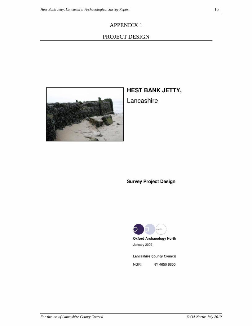
1.1.1 Oxford Archaeology North (OA North) was invited by Peter Iles of LancashireCounty Council Archaeology Service to undertake a topographic survey of HestBank Jetty, Lancashire, a structure accessible only around low tide. The jetty islocated within Morecambe Bay (NY 4664 6691) (Fig 1), and was exposed during2004 when changes in direction of the river channels in Morecambe Bay,particularly the Keer Channel, gradually eroded the sands covering the structure(Iles 2006, 60). A programme of detailed topographic survey was undertaken inaccordance with a project design (Appendix 1) submitted by OA North in January2009 in response to a verbal brief. The aim of the project was to record thesurviving structure of the jetty at a time of rapid/dynamic erosion and coastalchange in order to assist in the future management of the monument. The surveywas undertaken during March 2009.
1.1.2 Historical Background: the jetty was constructed as a breakwater in 1820 ‘toenable small coasting vessels from Liverpool and Glasgow to discharge theircargoes at Hest Bank, from where they could be transported north and south bycanal; this traffic ceased after the opening of the railway in 1846. The remains ofthe jetty are now some distance from the sea’ (Farrer and Brownbill 1914, 137; Iles2006, 63). In the Lancaster Gazette of 16th September 1820 it was noted that 'Onthe 4th inst. The foundation was laid for a pier or breakwater, at Hest Bank. Aftergiving the last stroke to the stone, Mrs R G Bradley, of Slyne, presented theworkmen with a handsome donation and expressed her best wishes for the successof the undertaking' (ibid).
1.1.3 The location of the jetty would seem ideal at a nodal point for the redistribution andreshipment of both goods and passengers, where the distance between the Lancastercanal (constructed by 1797) and the coastline is at its narrowest, although thenorthern section of the canal, from Tewitfield to Kendal was not completed unit1819. The Jetty is also at the junction of the main road running between Kendal andLancaster and the start of the cross-bay over sands route into the Lake District(Plates 1 and 2). It is probable that this jetty was associated with a warehouse andattached yard, belonging to the Hest Back Canal Company, that was constructed in1819 (dated 1820) adjacent to the canal. The warehouse was sold off in 1831 and itis probable that the jetty had only a very short profitable life. The vessel Duke ofLancaster was launched on 9th March 1822 intended to be used between Liverpooland Lancaster, Hest Bank and Ulverston, and was the first steamer with passengersto be sailed up the bay (Slyne with Hest Local History Group - Canal Warehouse).
1.1.4 The expected shipping trade did not appear, in part due to the shallowness of thebay and channels making traffic difficult, and in addition, the construction ofGlasson Dock and its link to the Lancaster Canal in 1826 must have made the HestBank route uneconomic even before the construction of the railway (Iles 2006, 63).The jetty continued to be used sporadically, primarily for passenger traffic until itwas overtaken by the railway after 1847. By this time the arrival of a vessel at thejetty was sufficiently rare as to arouse local excitement. Such an event occurredwhen the steamer Windermere (Lancaster Gazette – February 1847) arrived at Hest

Hest Bank Jetty, Lancashire: Archaeological Survey Report 5
For the use of Lancashire County Council © OA North: July 2010
Bank to load a cargo of hoops and small wood which had been brought to the jetty(ibid).
1.1.5 Map Evidence: prior to the construction of the jetty (and the canal) the mostdetailed depiction of the area around Hest Bank, along with its over sands routeinto the Lake District, is shown on Yates' map of Lancashire, dated 1786 (Plate 1).The first depiction of the jetty (marked as a breakwater) was shown a little distanceoffshore of Hest Bank on Hennet's map of Lancashire in 1830 (Plate 2). It isinteresting to note that the cross sands coach route ran landward of the breakwaterand the small distance between the canal and the coastline is clearly evident. Thejetty may have rapidly silted up, and may have been encroached upon by the sands,as evident on the 1st Edition Ordnance Survey mapping of 1848 (Plate 3). The jetty(breakwater) is shown only partially exposed on the northern end, and thesubsequent Ordnance Survey mapping editions of 1891, 1913 and 1932 do notmark any evidence of the structure (Plates 4-6). The encroachment of sands ontothe jetty may have altered the course of Hatlex Beck on the eastern side of the jetty,as it is shown as going around the jetty in 1848 but has moved over it and to thesouth by the 1932 mapping. The rapid nature of the re-exposure of the jetty in 2004after the Keer Channel moved in the bay can be seen in aerial photography. In the1960s, and probably through to 2004, the jetty was completely covered by sands,although the salt marsh seems to have receded significantly by 2000 (Plates 7 and8) and presently the jetty is visible near, and at, low tide (Plates 9 and 10).

Hest Bank Jetty, Lancashire: Archaeological Survey Report 6
For the use of Lancashire County Council © OA North: July 2010
2. METHODOLOGY
2.1 INTRODUCTION
2.1.1 A programme of detailed topographic survey was undertaken in accordance withthe project design (Appendix 1). The survey consisted of two elements of recording:firstly, a detailed topographic survey of the jetty structure and associatedearthworks; and secondly, the semi-rectified photographic recording of theprincipal masonry retaining walls (Fig 2).
2.2 TOPOGRAPHIC SURVEY
2.2.1 A detailed topographic survey of the jetty was undertaken by a combination of GPSand total station techniques. The GPS, having slightly reduced accuracy, was usedfor the wider topography and the total station was used for recording the primarystructure. The total station survey was based upon a control network located bydifferential GPS. The survey recorded an area of topography on either side of thejetty and the stone ramp leading to the shore, generating a comprehensive plan ofthe structure and environs, including all historic features, the dressed blocks aroundthe edge of the jetty, and in-situ timbers. It highlighted areas of damage, and alsorecorded spot heights along the length of the terrace. The elevations were recordedby semi-rectified photography.
2.2.2 Survey Control: the survey control was established over the site by closed traverse,accurate to +-0.015m, which was located onto the Ordnance Survey National Gridby means of Differential Global Positioning Survey (GPS), accurate to +- 0.05m.
2.2.3 Detail Survey: a detailed survey of the wider topography and part of the boulderramp extending between the shore and the jetty was undertaken using thedifferential GPS, accurate to +- 0.05m, but the structure of the jetty, including thedressed masonry structure, was surveyed by EDM tacheometry using a total station(Figs 3-8). The digital data was transferred onto a pen computer for manipulationand transfer to other digital or hard mediums. The data from both techniques wascombined in AutoCAD and paper plots were produced for completion by handsurvey, and the final drawings were subsequently generated within AutoCAD.
2.2.4 Terrace Wall Elevations: a record of the elevations of the jetty walls wasundertaken, using semi-rectified photography with respect to control established byreflectorless instrument survey (Figs 9-15). A series of photographs of each wallwas taken, with each frame containing at least four survey control targets. Thephotography was undertaken using a high-resolution digital SLR camera (8megapixel). The photography was digitally corrected using PhotoPlan software,which converted the semi-oblique images into fully rectified images. The correctedimages were then combined within AutoCad to create a single, survey corrected,photograph of the full length of each wall.
2.2.5 A general photographic record of the structure and its topographic context wascreated using a digital camera. This was intended to provided detail shots ofindividual components, as well as the wider context.

Hest Bank Jetty, Lancashire: Archaeological Survey Report 7
For the use of Lancashire County Council © OA North: July 2010
2.3 ARCHIVE
2.3.1 The results of the archaeological project form the basis of a full archive toprofessional standards, in accordance with current English Heritage guidelines (TheManagement of Archaeological Projects, 2nd edition, 1991). The project archiverepresents the collation and indexing of all the data and material gathered duringthe course of the project. This archive is provided to the Lancashire Record Officein the English Heritage Central Archaeological Services format. A synopsis(normally the index to the archive and the report) will be placed in the LancashireHistoric Environment Record. The archive will include the raw survey digital datain AutoCAD 2004 format.

Hest Bank Jetty, Lancashire: Archaeological Survey Report 8
For the use of Lancashire County Council © OA North: July 2010
3. RESULTS
3.1 INTRODUCTION
3.1.1 The aim of the survey was to provide a full visual record of the present state ofpreservation of the recently exposed jetty, including both topographic survey andsemi-rectified photographic recording of the surviving jetty walls. The results formthe basis of a descriptive record and interpretation of the various recorded elementsof the jetty, along with their possible functions and present survival. A key to thelocations of figures and elevations in the topographic survey are presented inFigures 2 and 9.
3.2 DESCRIPTIVE RECORD OF THE JETTY
3.2.1 The jetty consists primarily of a linear cobble-constructed, relatively flat, platformrunning on a diagonal angle (orientated north-west/south-east) at a little distancefrom the present coastline forming what would have originally been an isolatedbreakwater (Plate 9) (Fig 3). The southern end of the structure is less well definedand consists of a curvilinear bank of cobbles that run to the shoreline and wouldhave originally formed an access causeway at low tide (Plate 10). The main part ofthe structure has a shallow-sided, curved profile on its seaward side in order todissipate the effects of storm waves, and there is evidence of partially survivingelements of a layer of densely-packed set cobbles (Feature 1) forming the northernend of the outer seaward face of the jetty (Plate 11). The inner construction of thejetty is of large beach cobbles with a packing of smaller cobbles on the outersurfaces, much of the latter has been eroded away over years of storms and tidesleaving a slightly uneven upper surface with much of the finer material having beenstripped away (Plate 12).
3.2.2 The northern and north-eastern edges of the jetty have been revetted using largesandstone dressed masonry blocks, forming a near vertical, but slightly stepped-inor swept-back wall (Feature 2) (Figs 4, 5, 12-15; Plates 13 and 14), surviving up tonine courses high on the curving northern end. The wall originally providedanchorage on the landward side at what is now a narrow stream gully. A localresident mentioned that sand-filled keel marks could occasionally be seen in the silton this side of the jetty. The original parapet stones (Feature 3) of the wall arepartially evident at the northern end, notably where the jetty wall top is sloped onthe western side; here it stands proud of the rest of the structure by up to 1m wideand 0.5m high (Fig 14; Plates 15 and 16). The parapet at the northern end hassocket holes extending from its upper surface, some with lead inserts, and maysuggest that a section of railings once stood on it.
3.2.3 The north-east face of the jetty wall has surviving, fragmentary, elements of at leastnine squared, vertical wooden posts (Feature 3) (Figs 4-6, 10-12), with an iron-bracketed framework, and there were originally two horizontal rows of woodentimbers dovetailed between them (Feature 4) (Figs 10 and 11; Plates 13 and 14).The structure would have run the entire length of the wall, judging by the extent ofthe surviving iron brackets and/or socket holes and would have acted as fenders orrubbing strip to stop vessels damaging the structure. The posts on the southern halfof the jetty wall extend above the current upper surface of the wall, suggesting thatthe wall has been eroded or scavenged of stones in this location (Plate 17). The
Hest Bank Jetty, Lancashire: Archaeological Survey Report 9
For the use of Lancashire County Council © OA North: July 2010
southern end of the main jetty structure has a return of a linear wall (Feature 5) ofdressed sandstone blocks visible running from the landward side of the structure,making the original breakwater approximately 58m long by up to 37m wide (Fig 5).
3.2.4 There are several further fragmentary elements of jetty furniture surviving on thesurface of the main structure, albeit in a damaged and possibly slightly displacedform. Firstly, there is a rounded wooden pole set between two iron-bracedsandstone blocks amongst other disturbed blocks near the northern landward cornerof the structure (Feature 6), this may have formed the base for a small crane or anavigation warning flagpole (Fig 4). There are three large sandstone blocks (andpossibly a fourth adjacent to the wooden pole) (Feature 7), placed parallel with thelandward edge of the jetty wall, each containing the rusted remains of an iron chainset into the upper surface. The blocks are probably part of a mechanism foranchoring vessels to the jetty. In addition, there is a displaced sandstone block witha pair of upright posts on one side surviving on the western end of the northernedge of the jetty (Feature 8). This has been suggested as being the base for apractice target on the basis of the finding of a significant number of bullets,identified as small-arms ammunition of the 1850s-1880s, and included rounds fromthe Martini-Henry 0.577/0.450 calibre rifle. This alternative use would have onlyoccurred once the structure had gone out of use as a jetty, possibly in the late 1860s-1870s (SHLHG – the Hest Bank Wharf). Finally, there is a collection of threeriveted iron plates (Feature 9) surviving on, and extending away from, the south-east corner of the jetty structure (Fig 5). These may have formed some sort ofaccess ramp onto the structure or possibly a base or housing for machinery.
3.2.5 Southern Jetty Structure: extending south from the obvious cross wall (Feature 5)is a discontinuous continuation of the jetty wall, which is generally less well-defined (Figs 5 and 6). A short section of the landward retaining wall (Feature 10)survives adjacent to the iron plates, and extends south from the jetty corner. Furtherto the south are two sections of retaining wall (Feature 11) and a possible outercorner section of wall (Feature 12). The north-eastern side of this section of thestructure is associated with a series of five surviving vertical posts, and one has asurviving diagonal bracing post running behind it. The posts would have originallyformed a line of braced posts running the entire length of this section of the jetty,similar to the line in the northern part of the jetty. There is also a chain anchor point(Feature 7c) set a similar distance out from the jetty wall as those to the north(Features 7a and 7b). The walls of the landward end of the jetty (Features 11 and12) are only foundations and have either been reduced or have degraded over time.
3.2.6 Causeway: extending in a curved line out from the end of the jetty is a raisedcauseway, with cobbled surfaces on top (Figs 7 and 8). The embankment has ashallow, sloped profile on both northern and southern sides; however, it seems thatthe erosion of waves and tides has spread the southern edge of the structure in asouth-westerly direction (Plate 10). The eastern end of the causeway is obscured,where it is overlain by blocks of detached clay that reflect the collapse of, andretreat, of a shore edge that post-dates the jetty. The line of the causeway curvesaway from the southern section of the jetty structure and the cobbled surface inplaces overlies these sections of walls (Features 11 and 12). The implication is thatthe causeway overlies and post-dates the walls.
3.2.7 Despite 175 years of sea erosion it still has a relatively smooth upper surface andwas evidently intended to accommodate wheeled vehicles. In the course of its life,

Hest Bank Jetty, Lancashire: Archaeological Survey Report 10
For the use of Lancashire County Council © OA North: July 2010
however, it may have been resurfaced at various stages, as the cobbles are ofdifferent sizes in different sections. The northern most section (Feature 13) haslarger cobbles than the surface of the southern section (Feature 14).
3.3 PHASING
3.3.1 There are two sections of the jetty wall (Features 2 and 11), which are seemingly ofthe same basic design. They have similar sized foundation blocks, they are edgedby similar timber uprights, have similar chain anchor stones, and they are in line.However, the southern section (Feature 11) is very degraded, survives only as afoundation and is overlain by a section of the causeway, which diverts away fromthe line of the jetty leaving elements of the wall in the middle of the causeway. Theimplication is that the original jetty was a much longer structure (c103m long),which was shortened at some stage in its life with the insertion of cross wall –Feature 5. From then on the southern section (Feature 11) was redundant, and as thelength of the jetty was reduced, so the line of the causeway was able to change itsline to seek a more direct route to the coast. The causeway was diverted away fromthe early line, and was built over the southern jetty wall, which was reduced so thatit did not pose an obstacle to the wheeled vehicles using the causeway. The reasonthat the jetty was reduced in length is not certain, but could even have beenspecifically to accommodate the changing line of the causeway.

Hest Bank Jetty, Lancashire: Archaeological Survey Report 11
For the use of Lancashire County Council © OA North: July 2010
4. DISCUSSION
4.1 DEVELOPMENT AND USE OF THE JETTY
4.1.1 It is clear from documentary research that the jetty was an integral part of the HestBank Canal Company’s scheme to provide passenger traffic and cargo reshipmentusing Hest Bank as a nodal point at the junction of the canal, the sea and the roadnetwork in the north-west. The short-lived enterprise entailed, for the most part,trade with Liverpool from c1820 until 1831 when the associated canal warehousewas sold off; the jetty foundation stone being lain on the 4th September 1820.
4.1.2 The present survey has revealed that the main structure of the jetty was retained bya sandstone wall on the northern end, and it is to be presumed that the walledstructure equates to the ‘breakwater’ that is shown on Hennet’s map of Lancashire(Plate 2). Analysis of the extant remains suggests that the original structure (Phase1) was an extremely long (c103m in length) platformed structure from which acauseway (Feature 13) extended eastwards to the shore. At some subsequent datethe structure was shortened, with a clear delineation where the sandstone wallreturns at the southern end (Feature 5; Fig 4), and the line of the causeway waschanged, overlaying part of the earlier structure (Feature 11). This later causeway,which connects the jetty to the coastline, consists of a narrow shallow-sidedembankment, presumably only navigable at low tide and distinct in form from the‘breakwater’/ jetty.
4.1.3 The inner construction of the jetty is essentially similar across all areas, being amixture of layers of large packed cobbles and smaller packed cobbles. There is alsoevidence that the sloping seaward side of the jetty (at least on the main structure)originally had a well-packed cobble surface (Feature 1) to dissipate the waves (Fig3; Plate 11). Erosion in the form of storm damage, tidal action and also probablystone scavenging have affected the upper surfaces of the jetty, displaced some ofthe sandstone wall and parapet and removed significant areas of the cobbledsurfaces.
4.1.4 Various architectural elements have been identified that are pertinent to the use ofthe jetty, namely a flagpole (Feature 6), or more likely a base for a crane, acollection of iron plates for a base or access ramp (Feature 9), three or four,anchoring points consisting of iron chains secured in sandstone blocks (Feature 7).There are also the fragmentary remains of a series of iron-bracketed, and braced,wooden fenders (Features 3 and 4), and slight evidence for the original location ofrailings on the northern end of the jetty.
4.1.5 The jetty evidently had a short economically viable life, it was not an idealanchorage, being shallow with only limited accessibility. The construction ofGlasson Dock, and its link to the canal, in 1826, may have made the Hest Bankjetty redundant even before the construction of the railway in 1847. After the mainphase of use in c1820-1831, the jetty was only used sporadically and mainly forpassenger traffic with evidence that it was used at least once as late as 1847 (Iles2006, 63). The next year the Ordnance Survey mapping depicted the ‘breakwater’as being partially blocked up and presumably was being encroached upon by thesands, it is unknown if the anchorage was ever dredged out but presumably achange in the course of the Keer channel facilitated sand deposition. At least thetop of the jetty was still exposed in the late 1860s-1870s when a target was set up

Hest Bank Jetty, Lancashire: Archaeological Survey Report 12
For the use of Lancashire County Council © OA North: July 2010
on the northern end of the jetty for military weapons practice (Iles 2006; SHLHG –the Hest Bank Wharf). It is unknown when the structure was finally envelopedentirely by the sands but there is no further evidence that any part of the jetty wasexposed above the sands again until 2004 when a change in the course of the Keerchannel started to rapidly expose the structure.
4.2 RECOMMENDATIONS FOR FURTHER WORK
4.2.1 Documentary Research: it is recommended that a volunteer project be establishedto further collect, and assess, primary documentary information regarding the HestBack Canal Company, its jetty and associated canal warehouse, c1819-1831. Abrief search of online archive repositories have identified at least two potentialsources of information in Cumbria Record Office, Kendal, which would warrantfurther study.
4.2.2 Interpretation: drawing upon the present survey, and further documentaryresearch, it is suggested that two interpretation panels be designed, one for erectionat the car park adjacent to the jetty and also possibly one near to the formerwarehouse on the canal.
4.2.3 Monitoring: there is little scope for further mitigative archaeological works to beundertaken on the jetty. There is, however, a case for undertaking periodicmonitoring visits to identify further erosion, changes in condition, and the exposureof additional archaeological deposits. Subject to significant changes in conditionthere may be a requirement for further recording.

Hest Bank Jetty, Lancashire: Archaeological Survey Report 13
For the use of Lancashire County Council © OA North: July 2010
5. BIBLIOGRAPHY
5.1 PRIMARY SOURCES
5.1.1 Consulted Sources
Yates’ Map of Lancashire, 1786Hennet’s Map of Lancashire, 1830
OS 1st Edition, 6 inch to 1 mile, 1848, Sheet XXIV.SWOS Edition (1891), 25 inch to 1 mile, Sheet XXIV.15
OS Advanced Edition (1913), 25 inch to 1 mile, Sheet XXIV.15OS Edition (1932), 25 inch to 1 mile, Sheet XXIV.15
Lancashire County Council, Aerial photography, dated c1960 and 11th May 2006,mario.lancashire.gov.uk accessed 21st June 2010
Lancaster Gazette – February 1847 Article on the arrival of the steamer Windermereat Hest Bank
Google Earth, Aerial/Satellite photography, dated c2000, earth.google.co.uk accessed21st June 2010
5.1.2 Potential Sources at, Cumbria Record Office, Kendal - not investigated:
WDB 12/7 1824-1831: Account of insurance paid upon goods from Liverpool toHest Bank, 1824-1831, recording the nature of goods, insurance paid, and on whatvessel they were carriedWDB 12/8 1823-1858: Shipping registers Entitled ‘account of Goods by Sea to thedifferent Ports of Great Britain when forwarded, reshipped etc’ – This records goodsshipped, the ship, to which port, how they were reshipped, through which port, etc.The ships include Kent, Eliza and Rigby; the Canal was used extensively forreshipping to and from such ports as Glasson, Liverpool and Milnthorpe
5.2 SECONDARY SOURCES
Association of County Archaeological Officers (ACAO) 1993. Model briefs andspecifications for Archaeological Assessments and Field Evaluations, Bedford
English Heritage, 1991 Management of Archaeological Projects, 2nd edn, London
Farrer, W, and Brownbill, J, (eds) 1914 the Victoria Histories of the Counties ofEngland: History of Lancashire, 8, London, 136-139
Iles, P, 2006 The Hest Bank Jetty, Contrebis, 30, 60-65Institute of Field Archaeologists (IFA), 1992 Guidelines for data collection andcompilation.
Lancaster University Archaeological Unit (LUAU) 1996a Lyme Park NurseryGardens, archaeological evaluation, unpubl rep

Hest Bank Jetty, Lancashire: Archaeological Survey Report 14
For the use of Lancashire County Council © OA North: July 2010
Lancaster University Archaeological Unit (LUAU) 1996b Bostock Hall WalledGarden, Structural Survey and Evaluation report, unpubl repLancaster University Archaeological Unit (LUAU) 1997a Lyme Park: Detailedaspects of the historical and landscape development, unpubl repLancaster University Archaeological Unit (LUAU) 1999 Rectory Woods GardensSurvey, unpubl repSlyne with Hest Local History Group (SHLHG) – The Hest Bank Wharf,http://www.slyne-with-hest.org.uk/local%20history/wharf.htm accessed 14th February2009
Slyne with Hest Local History Group (SHLHG) – Canal Warehouse,http://www.slyne-with-hest.org.uk/local%20history/CanalWarehouse.pdf accessed14th February 2009
Hest Bank Jetty, Lancashire: Archaeological Survey Report 15
For the use of Lancashire County Council © OA North: July 2010
APPENDIX 1
PROJECT DESIGN
Hest Bank Jetty, Lancashire: Archaeological Survey Report 16
For the use of Lancashire County Council © OA North: July 2010
1. INTRODUCTION
1.1 CONTRACT BACKGROUND
1.1.1 Peter Iles of Lancashire County Council has invited Oxford Archaeology North to submit aproposal for a topographic survey of the Hest Bank Jetty, Lancashire, which will inform themanagement of the monument. The jetty is located within Morecambe Bay, and is primarilyaccessible around low tide.
1.1.2 Archaeological Background: the jetty was constructed as a breakwater in 1820 ‘to enable smallcoasting vehicles from Liverpool and Glasgow to discharge their cargoes at Hest Bank, fromwhere they could be transported north by canal. This traffic ceased after the opening of therailway in 1846’ (Farrer and Brownbill 1914, 137; Iles 2006, 63). It is probable that this trade wasassociated with a warehouse, belonging to the Hest Back Canal Company, which was sold in 1831and it is therefore possible that the jetty had a very short profitable life.
1.2 OXFORD ARCHAEOLOGY NORTH
1.2.1 Oxford Archaeology North (OA North), formerly Lancaster University Archaeological Unit, hasconsiderable experience of the archaeological survey of sites and monuments of all periods, havingundertaken a great number of small and large projects during the past 20 years. OA North employsa qualified archaeological and landscape surveyor (Jamie Quartermaine BA DipSurv MIFA) whohas over 19 years experience of surveying buildings and landscapes, having worked closely withthe Royal Commission on the Historical Monuments of England and the Lake District NationalPark Authority on numerous projects. OA North has particular experience in the recording andanalysis of park landscapes and formal gardens. OA North has also undertaken a detailed survey ofa complex garden at Rectory Wood Gardens Heysham Head again for the National Trust (LUAU1999). Lathom Park, was the seat of the Stanley family, and was at one time the most powerfulseat in the North-West. OA North is involved in an on-going programme of excavation, survey,documentary study, and fabric survey intended to identify the evidence for the fourteenth centurypalace and investigate the development of the park.
1.3.3 Projects have been undertaken to fulfil the different requirements of various clients and planningauthorities, and to very rigorous timetables. OA North is accustomed to undertaking projects tostrict timetables, and to fulfil a wide variety of requirements. OA North is one of the bodiesendorsed by the IFA (Institute of Field Archaeologists) (No. 17) and has both the expertise andresources to undertake this project to the highest standards
2. AIMS
2.1 OA North will undertake an archaeological survey of the Jetty, which will provide a plan of thestructure as well as a rectified photographic record of the principle retaining walls.
3. METHOD STATEMENT
3.1 The following work programme is submitted in line with the objectives of the archaeological worksummarised above.
3.2 TOPOGRAPHIC SURVEY
3.2.1 It is proposed that a detailed topographic survey of the jetty be undertaken, which will beundertaken by a combination of GPS and total station techniques. The GPS, having slightlyreduced accuracy, will be used for the wider topography and the total station will be used forrecording the structure. The total station survey will be based upon a control network located bydifferential GPS. It is proposed to survey an area of topography on either side of the jetty and thestone ramp leading to the shore, health and safety permitting. The survey will generate acomprehensive plan of the structure, and the elevations will be recorded by semi-rectifiedphotography. The ground plan will show all historic features of the structure, and the surroundingtopography, and will include the individual dressed blocks around the edge of the jetty, as well asall in-situ timbers. It will highlight areas of damage, and will also record spot heights along thelength of the terrace.
Hest Bank Jetty, Lancashire: Archaeological Survey Report 17
For the use of Lancashire County Council © OA North: July 2010
3.2.2 Survey Control: survey control will be established over the site by closed traverse and internallywill be accurate to +- 15mm. It is proposed that the control network be located onto the OrdnanceSurvey National Grid by the use of Differential Global Positioning Survey (GPS), which willlocate to an accuracy of +- 0.05m.
3.2.3 Detail Survey: the wider topography and part of the boulder ramp extending between the shoreand the jetty will be undertaken using the differential GPS, which can achieve accuracies of +-0.05m, but the structure of the jetty, including the dressed masonry structure, will be surveyed bytotal station. The total station survey will be generated by EDM tacheometry using a total stationlinked to a pen computer running TheoLT software. The digital data is transferred onto the pencomputer for manipulation and transfer to other digital or hard mediums. The survey data will beaccurate to +- 0.01m. The topographic survey will record all structural components, such as thejetty walls. The data from both techniques will be combined in CAD and paper plots will beproduced for completion by hand survey. The final drawings will be generated within a CADsystem and can be output at any scale, and can also be provided in digital format for incorporationwithin a GIS system.
3.2.4 The topographic survey will record all principal archaeological features and all timbers, and willentail an examination of the full extent of the ramp extending from the jetty. A descriptive recordof all features will be produced, which will incorporate a provisional interpretation of the functionof each feature, where possible, and similarly will provide a provisional interpretation of theoverall monuments construction.
3.2.5 Profile Survey: a profile will be produced from the western end of the jetty along the length of theramp towards the shore and will serve to demonstrate the extent to which a level surface wasmaintained along its length. A similar profile will be established across the jetty.
3.3 TOPOGRAPHIC PHOTOGRAPHIC RECORDING OF THE TERRACE WALLS
3.3.1 Preparation: it is proposed to undertake a rectified photographic survey of the jetty walls;however, presently much of the walls are covered in kelp. It will be necessary to remove as muchof the kelp as possible in advance of the survey.
3.3.2 Semi-Rectified Photographic Record: a record will be created of the elevations of the jetty walls,using semi-rectified photography with respect to control established by reflectorless instrumentsurvey. In order to maximise quality and best value, face on photography will be undertaken, toprovide a basic record of the walls. A series of photographs of each wall will be taken, each framecontaining several survey control targets, which will be surveyed using a reflectorless total station.The photography will be undertaken by in-house survey specialists and will be undertaken incolour, using a high-resolution digital SLR camera (8 megapixel). Where physical access in frontof the wall is impeded by the adjacent channel, an extendable mast will be used to extend thecamera beyond the wall so as to photograph it. The photography will be imported into AutoCAD,where each image will be digitally corrected using PhotoPlan software to convert them into fullyrectified images. The corrected images will then be combined within AutoCad to create a single,survey corrected, photograph of the full length of each wall. In Autocad the wall image will bedivided into individual sections for convenience.
3.3.2 In addition a general oblique photographic record will be made of the structure showing detailadditional to that provided by the rectified photography.
3.4 REPORT AND ARCHIVE
3.4.1 Archive: the results of the archaeological project will form the basis of a full archive toprofessional standards, in accordance with current English Heritage guidelines (The Managementof Archaeological Projects, 2nd edition, 1991). The project archive represents the collation andindexing of all the data and material gathered during the course of the project. This archive will beprovided to the Lancashire Record Office in the English Heritage Central Archaeological Servicesformat. A synopsis (normally the index to the archive and the report) should be placed in theLancashire Historic Environment Record. It is normal OA North practice to make a copy of thearchive available for deposition with the National Archaeological Record in Swindon. The archivewill include the raw survey digital data in AutoCAD 2004 format.
3.4.2 Report: a brief report will present, summarise, and interpret the results of the programme detailedin Stages 3.1-3.3 above, and will include a full index of archaeological features identified in thecourse of the project. The reports will consist of an acknowledgements statement, lists of contents,

Hest Bank Jetty, Lancashire: Archaeological Survey Report 18
For the use of Lancashire County Council © OA North: July 2010
summary, introduction summarising the brief and project design and any agreed departures fromthem. A brief summary of the history of the site will be included, but the emphasis will be onpresenting the physical remains and defining and integrating them within a historical context.
3.4.3 The report will identify the significance of the archaeological and architectural evidence and willinclude the following:
• Results of the archaeological survey, presented in conjunction with the historic mapping.
• An interpretative account of the development of the monument from its inception to thepresent. The report will highlight those elements of the original design that have eitherbeen lost or severely degraded.
• An integrated discussion of the works within a historical context.
• Recommendations for further archaeological works that would mitigate further damageby sea action.
3.4.4 The report will also include a complete bibliography of sources from which the data has beenderived, and a list of further sources identified during the programme of work.
3.4.5 The report will incorporate appropriate illustrations, including copies of the site plans, surveymapping, all reduced to an appropriate scale. The site mapping will be based upon the CAD base.The report will be accompanied by photographs and historic illustrations illustrating the principalelements of the monument. Four bound and one unbound copies of the report will be submitted. Inaddition to the paper copies of the report digital copies of the report and drawings will besubmitted. The final drawings will be in AutoCAD Map 2004 formats.
4. OTHER MATTERS
4.1 ACCESS
4.1.1 It is assumed that the client will ensure access to the full extent of the study area. The kelpobscuring the structure will need to be removed in advance of the survey.
4.2 HEALTH AND SAFETY
4.2.1 Full regard will, of course, be given to all constraints (services) during the survey, as well as to allHealth and Safety considerations. The OA North Health and Safety Statement conforms to all theprovisions of the SCAUM (Standing Conference of Unit Managers) Health and Safety manual.Risk assessments are undertaken as a matter of course for all projects, and will anticipate thepotential hazards arising from the project.
4.2.2 As the work will entail working on the edge of Morecambe Bay, considerable care will be taken tominimise risk from tidal action, soft silts and sands. Work will only be undertaken during a periodof two hours on either side of low tide. Staff will work in pairs at all times. There is safe accessalong the line of the ridge separating the jetty from the shore, but not on either side, where thesands have the potential to be very soft and could entrap a pedestrian. Care will be taken to onlywalk on solid sands and surface boards will be used to provide a safe surface for any work onsofter sands.
4.3 INSURANCE
4.3.1 The insurance in respect of claims for personal injury to or the death of any person under acontract of service with the Unit and arising in the course of such person's employment shallcomply with the employers' liability (Compulsory Insurance) Act 1969 and any statutory ordersmade there under. For all other claims to cover the liability of OA North in respect of personalinjury or damage to property by negligence of OA North or any of its employees there applies theinsurance cover of £10m for any one occurrence or series of occurrences arising out of one event.
4.4 CONFIDENTIALITY
4.4.1 The report is designed as a document for the specific use of the Client, for the particular purpose asdefined in this project design, and should be treated as such. Any requirement to revise or reorderthe material for submission or presentation to third parties or for any other explicit purpose can befulfilled, but will require separate discussion and funding.

Hest Bank Jetty, Lancashire: Archaeological Survey Report 19
For the use of Lancashire County Council © OA North: July 2010
5. WORK TIMETABLE 5.1 The phases of work will comprise the following elements. The days quoted are the duration for
each individual task
i) Clearance of Kelp 1 half day
ii) Field Survey 4 half days - field work
iii) Rectified Photographic Survey 1 half day - field work
2 days - Office
iv) Report Production 15 days
5.2 TIMETABLE
5.2.2 The survey can be initiated as soon as the project is commissioned, but the field work will firaround the tide timetable and at certain times, the configuration of tides will not allow for anadequate working window, and in this case the fieldwork will be delayed.
6. RESOURCES
6.1 PROJECT TEAM
6.1.1 The survey will be undertaken by Chris Wild (Project Officer), under the guidance of the projectmanager, Jamie Quartermaine. Although present scheduling precludes the identification of thespecific archaeologists to direct and undertake the watching brief and trenching, OA North canguarantee that the tasks will be detailed to a suitably experienced archaeologist of supervisorialgrade. The report writing and analysis will be by Chris, who will also prepare the survey mapping,and descriptive results.
6.1.2 Project Management: the project will be under the project management of Jamie Quartermaine,BA Surv Dip MIFA (OA North Project Manager) to whom all correspondence should beaddressed. Jamie is a very experienced landscape surveyor, who has undertaken or managedliterally hundreds of surveys throughout Northern England since 1984, and has considerableexperience of working on similar projects to that proposed. He has managed a major recordingprogramme of Lyme Park, Cheshire, for the National Trust. He has also undertaken surveys ofLowther Park, Cumbria, Rufford Park, Lancashire and also a structural survey of Rufford OldHall, he has also managed the recording programme of Lathom Hall and Park, Lancashire. He hasbeen a project manager since 1995 and has managed over 450 very diverse projects since then,which are predominantly survey orientated, but of all periods from Palaeolithic to twentiethcentury.
6.1.3 The survey would be directed by Chris Wild, BSc. Chris has been with OA since 1993, and hasundertaken varied and wide-ranging projects. Since 1998 he has been the senior fieldworkbuildings archaeologist and surveyor within LUAU/OA North. This role has including a variety oflevels of recording and instrument survey work, with extensive experience of Total Station survey,Reflectorless Total Station survey using the TheoLT AutoCAD interface, and GPS survey, and themanipulation of this data to produce report quality drawings via three-dimensional CAD packages.He is competent with many types of photographic recording and regularly implements in-housetraining on rectified photography and the use of medium format cameras, as well as training ininstrument survey and building recording techniques.
6.1.4 Chris has directed projects on a wide range of building types and periods, including medievalcastles and farm complexes, early-post medieval housing, and vernacular, industrial, domestic andmilitary structures from the eighteenth century to the present date. Major projects that Chris hasundertaken include major building and/or earthwork surveys at Lancaster Castle; Kendal Castle;Bew Castle, Cumbria; Wigmore Castle, Herefordshire; Auchindrain Historic Township, Argyll;Lyme Park, Cheshire; Nenthead Lead Mines, Cumbria; Pilkington's Glass Works, St Helens; FlintGlass Works, Manchester.

Hest Bank Jetty, Lancashire: Archaeological Survey Report 20
For the use of Lancashire County Council © OA North: July 2010
ILLUSTRATIONS
FIGURES
Figure 1: Site Location
Figure 2: The location of Hest Bank Jetty, showing figure locationsFigure 3: The extent of the Hest Bank Jetty remains - survey results
Figure 4: Topographical survey – northern end of the jettyFigure 5: Topographical survey – central part of the jetty
Figure 6: Topographical survey – central part of the jettyFigure 7: Topographical survey – southern end of the jetty
Figure 8: Topographical survey – eastern end of the jettyFigure 9: Location of elevations
Figure 10: North-east facing elevation (east end)Figure 11: North-east facing elevation (west end)
Figure 12: North-north-east facing elevationFigure 13: North-north-west facing elevation
Figure 14: North-west facing elevation (east end)Figure 15: North-west facing elevation (west end)
PLATES
Plate 1: Yates’ map of Lancashire, 1786
Plate 2: Hennet’s Map of Lancashire, 1830Plate 3: OS 1st Edition, 6 inch to 1 mile, 1848, Sheet XXIV.SW
Plate 4: OS Edition (1891), 25 inch to 1 mile, Sheet XXIV.15Plate 5: OS Advanced Edition (1913), 25 inch to 1 mile, Sheet XXIV.15
Plate 6: OS Edition (1932), 25 inch to 1 mile, Sheet XXIV.15Plate 7: Aerial photograph of the area of the jetty, c1960 (©
mario.lancashire.gov.uk)
Plate 8: Aerial photograph of the area of the jetty, c2000 (© earth.google.co.uk)
Plate 9: Aerial photograph of the area of the jetty, 11 May 2006 (©mario.lancashire.gov.uk)
Plate 10: General view of Hest Bank Jetty looking north-westPlate 11: Area of cobbled floor on the northern end of the south-west facing side
of the jettyPlate 12: Disturbed cobbled construction in the centre of the jetty
Plate 13: North-eastern end of the north-east-facing dressed jetty wall

Hest Bank Jetty, Lancashire: Archaeological Survey Report 21
For the use of Lancashire County Council © OA North: July 2010
Plate 14: Mid-section of the north-east-facing dressed jetty wall
Plate 15: Surviving outer edge of facing stones on the northern end of the jettyPlate 16: Profile of the northern end of the jetty walls
Plate 17: Disturbed edge of facing stones and wooden fenders on the north-eastside of the jetty
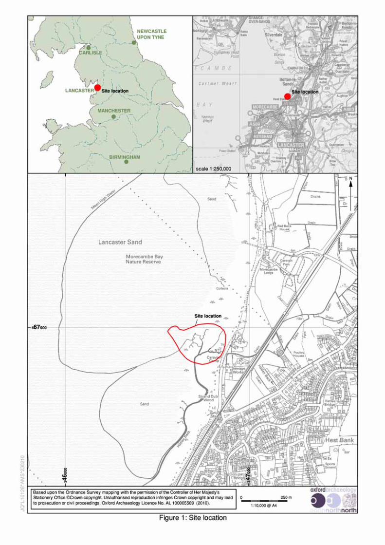
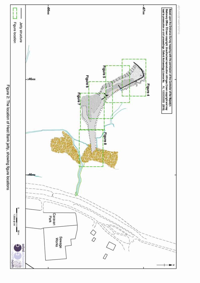

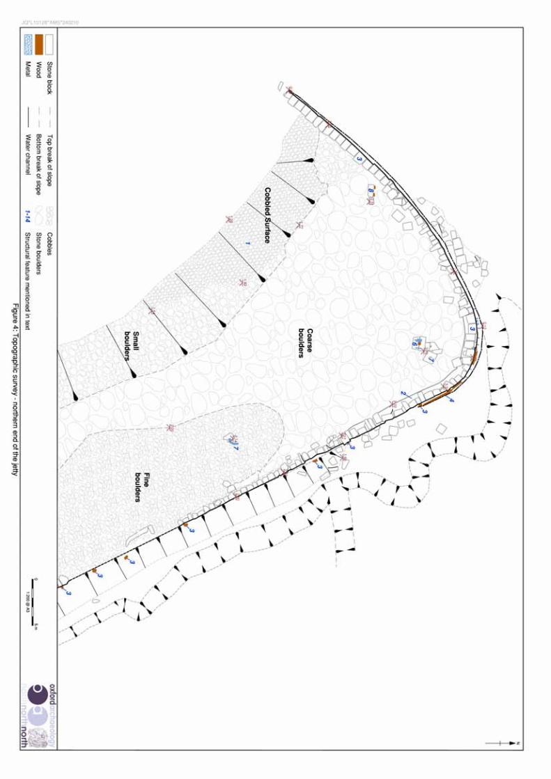


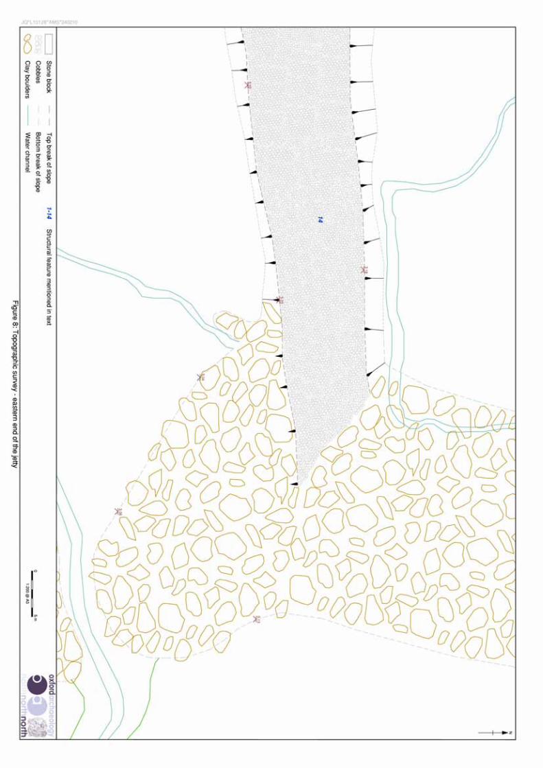
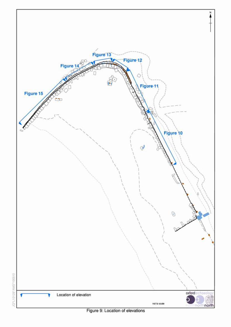


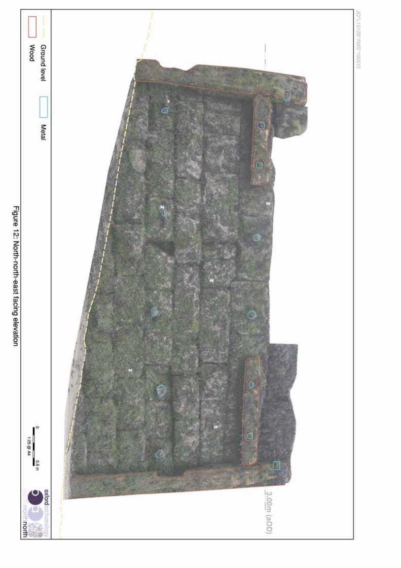


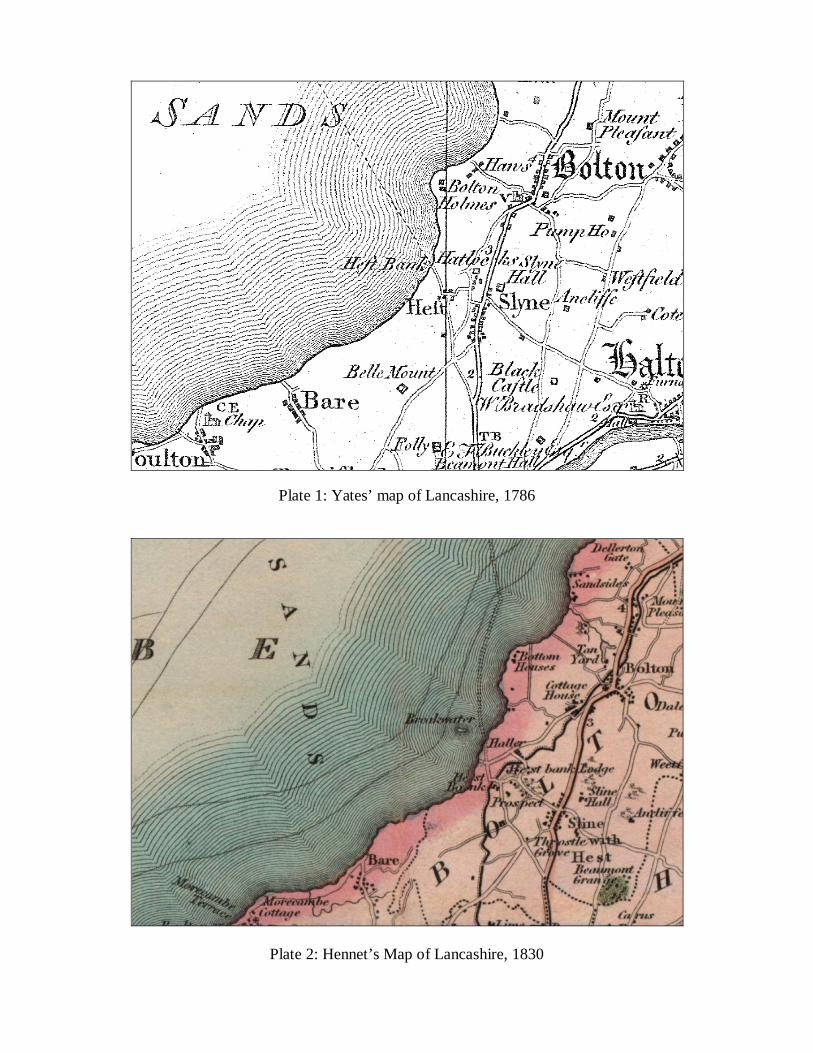
Plate 1: Yates’ map of Lancashire, 1786
Plate 2: Hennet’s Map of Lancashire, 1830

Plate 3: OS 1st Edition, 6 inch to 1 mile, 1848, Sheet XXIV.SW
Plate 4: OS Edition (1891), 25 inch to 1 mile, Sheet XXIV.15

Plate 5: OS Advanced Edition (1913), 25 inch to 1 mile, Sheet XXIV.15
Plate 6: OS Edition (1932), 25 inch to 1 mile, Sheet XXIV.15
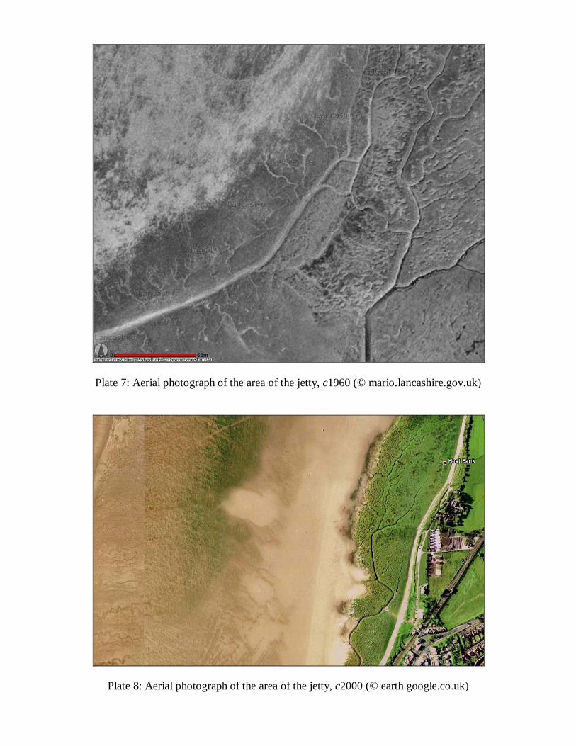
Plate 7: Aerial photograph of the area of the jetty, c1960 (© mario.lancashire.gov.uk)
Plate 8: Aerial photograph of the area of the jetty, c2000 (© earth.google.co.uk)

Plate 9: Aerial photograph of the area of the jetty, 11 May 2006 (©mario.lancashire.gov.uk)
Plate 10: General view of Hest Bank Jetty looking north-west

Plate 11: Area of cobbled floor on the northern end of the south-west facing side ofthe jetty
Plate 12: Disturbed cobbled construction in the centre of the jetty

Plate 13: North-eastern end of the north-east-facing dressed jetty wall.
Plate 14: Mid-section of the north-east-facing dressed jetty wall
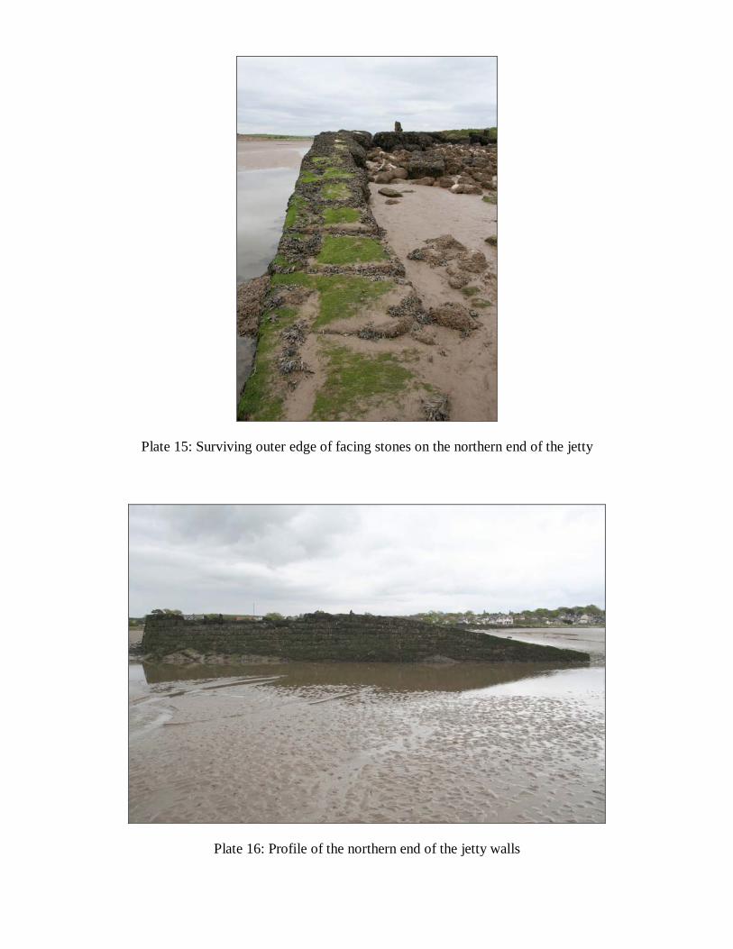
Plate 15: Surviving outer edge of facing stones on the northern end of the jetty
Plate 16: Profile of the northern end of the jetty walls
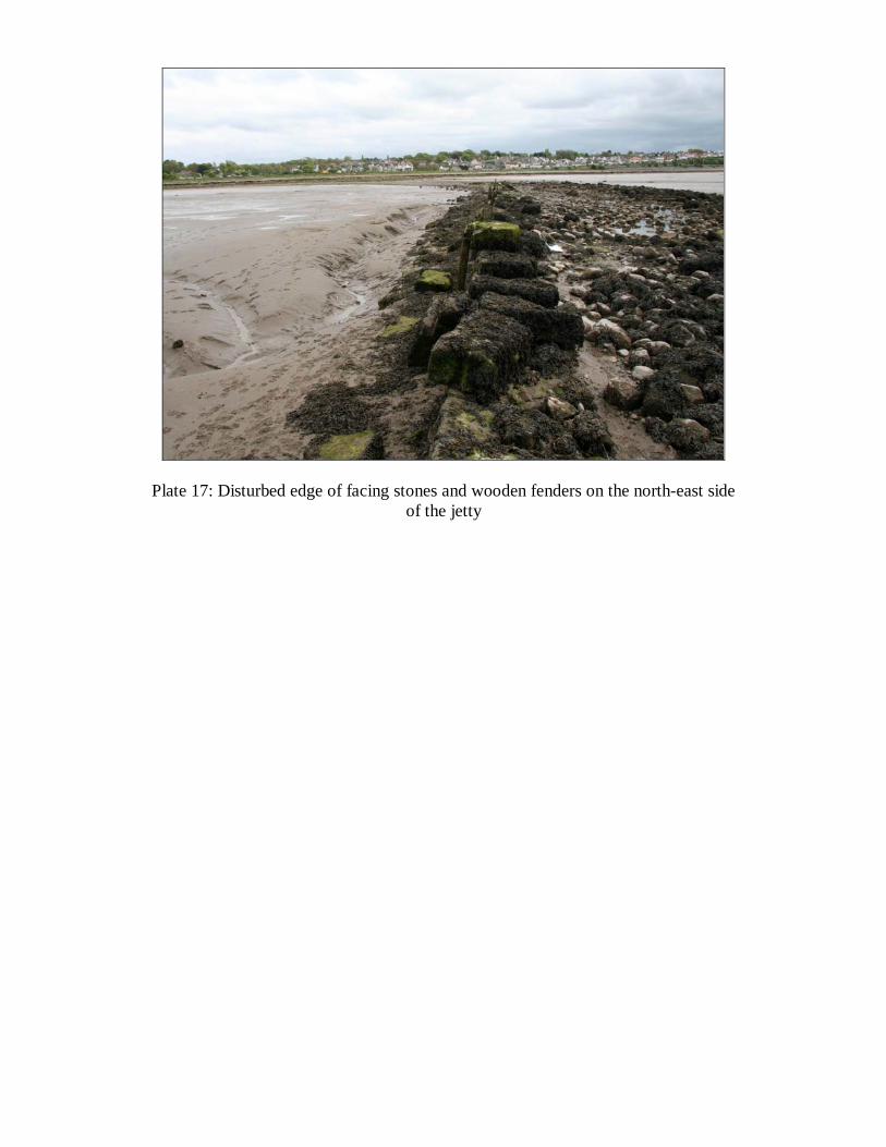
Plate 17: Disturbed edge of facing stones and wooden fenders on the north-east sideof the jetty