heber allotment environmental assessmenta123.g.akamai.net/7/123/11558/abc123/forestservic...heber...
TRANSCRIPT

United States Department of Agriculture
Heber Allotment Draft Environmental Assessment
Forest Service Apache-Sitgreaves National Forests
Black Mesa Ranger District May 2015

For More Information Contact: Kendell Hughes, Rangeland Management Specialist
Black Mesa Ranger District 2748 Hwy 260
Overgaard, AZ 85933 Phone: 928-535-7300
The U.S. Department of Agriculture (USDA) prohibits discrimination in all its programs and activities on the basis of race, color, national origin, age, disability, and where applicable, sex, marital status, familial status, parental status, religion, sexual orientation, genetic information, political beliefs, reprisal, or because all or part of an individual's income is derived from any public assistance program. (Not all prohibited bases apply to all programs.) Persons with disabilities who require alternative means for communication of program information (Braille, large print, audiotape, etc.) should contact USDA's TARGET Center at (202) 720-2600 (voice and TDD). To file a complaint of discrimination, write to USDA, Director, Office of Civil Rights, 1400 Independence Avenue SW, Washington, DC 20250-9410, or call (800) 795-3272 (voice) or (202) 720-6382 (TDD). USDA is an equal opportunity provider and employer.

Environmental Assessment
i
Contents
Chapter 1 - Project Overview & Need for the Project .............................................................................3 Introduction ...............................................................................................................................................3 Allotment Area Description & Background..............................................................................................3 Purpose and Need for Action ....................................................................................................................6 Proposed Action ........................................................................................................................................6 Apache-Sitgreaves Forest Plan Consistency .............................................................................................6 Decision Framework .................................................................................................................................6 Public Involvement ...................................................................................................................................7
Issues…………………………………………………………………………………………………….7
Chapter 2 - Alternatives .............................................................................................................................9 Alternatives Considered But Eliminated from Detailed Study .................................................................9 Alternatives Considered In Detail .............................................................................................................9
Alternative 1: No Action/No Grazing ....................................................................................................9 Alternative 2: Proposed Action .............................................................................................................9
Summary .................................................................................................................................................17 Chapter 3 - Affected Environment & Environmental Impacts of the Alternatives ............................18
Range & Vegetation ................................................................................................................................18 Watershed & Soils ...................................................................................................................................28
Wildlife ...................................................................................................................................................44
Fire & Fuels………………………………………………………………………………………...…104
Cultural Resources……………………………………………………………………………………106
Economic & Social…………………………………………………………………………………...108
Noxious Weeds……………………………………………………………………………………….111
Chapter 4 - Consultation and Coordination .........................................................................................111 All Documents Cited in the EA .................................................................................................................115 Appendix A- Project Design and Best Management Practices .................................................................123 Appendix B – Cumulative Effects Table ...................................................................................................128

Heber Allotment
ii
Document Structure The Forest Service has prepared this Environmental Assessment in compliance with the National
Environmental Policy Act (NEPA) and other relevant federal and state laws and regulations. This
Environmental Assessment discloses the direct, indirect, and cumulative environmental impacts that
would result from the proposed action and alternatives. The document is organized into four parts:
Introduction: This section includes information on the history of the project proposal, the purpose
and need for the project, and the agency’s proposal for achieving that purpose and need. This
section also details how the Forest Service informed the public of the proposal and how the public
responded.
Comparison of Alternatives, including the Proposed Action: This section provides a more detailed
description of the agency’s proposed action as well as alternative methods for achieving the stated
purpose.
Environmental Consequences: This section describes the environmental effects of implementing
the proposed action and other alternatives. This analysis is organized by resource area (i.e.
wildlife, soils, etc.). Within each section, the affected environment is described first, followed by
the effects of the No Action Alternative that provides a baseline for evaluation and comparison of
alternative 2.
Agencies and Persons Consulted: This section provides a list of preparers and agencies consulted
during the development of the environmental assessment.
Additional documentation, including more detailed analyses of project-area resources, may be found in
the project planning record located at the Black Mesa Ranger District Office in Overgaard, AZ.
Environmental Assessment
3
Chapter 1 Project Overview & Need for the Project
Introduction Analysis of the effects of livestock grazing under the National Environmental Policy Act (NEPA) of
1969 is mandated by the Range Rescission Act of 1995 (P.L. 104-19) for all allotments where grazing
occurs. Other laws governing grazing and use of public lands indicate Congressional intent to allow
grazing on suitable lands where consistent with other multiple use goals and objectives for
management of those lands (Multiple Use and Sustained Yield act of 1960, Forest and Rangeland
Renewable Resources Planning Act of 1974, Federal Land Policy and Management Act of 1976,
National Forest Management Act of 1976). Forest Service policy also indicates intent of the agency to
make forage producing suitable land available for grazing to qualified livestock operators consistent
with land management plans (FSM 2203.1, 36 CFR 22.2 (c)). Following these laws and regulations
and the Apache-Sitgreaves National Forests Land Management Plan (USDA 1987), an
interdisciplinary team of resource specialists developed this site-specific environmental assessment
analyzing the effects of a proposed action of authorizing livestock grazing, maintaining and installing
improvements, and restoring grassland and savanna as well as a no grazing alternative, as required by
Forest Service Handbook 2209.92.31, that would not authorize livestock grazing on the Heber
Allotment.
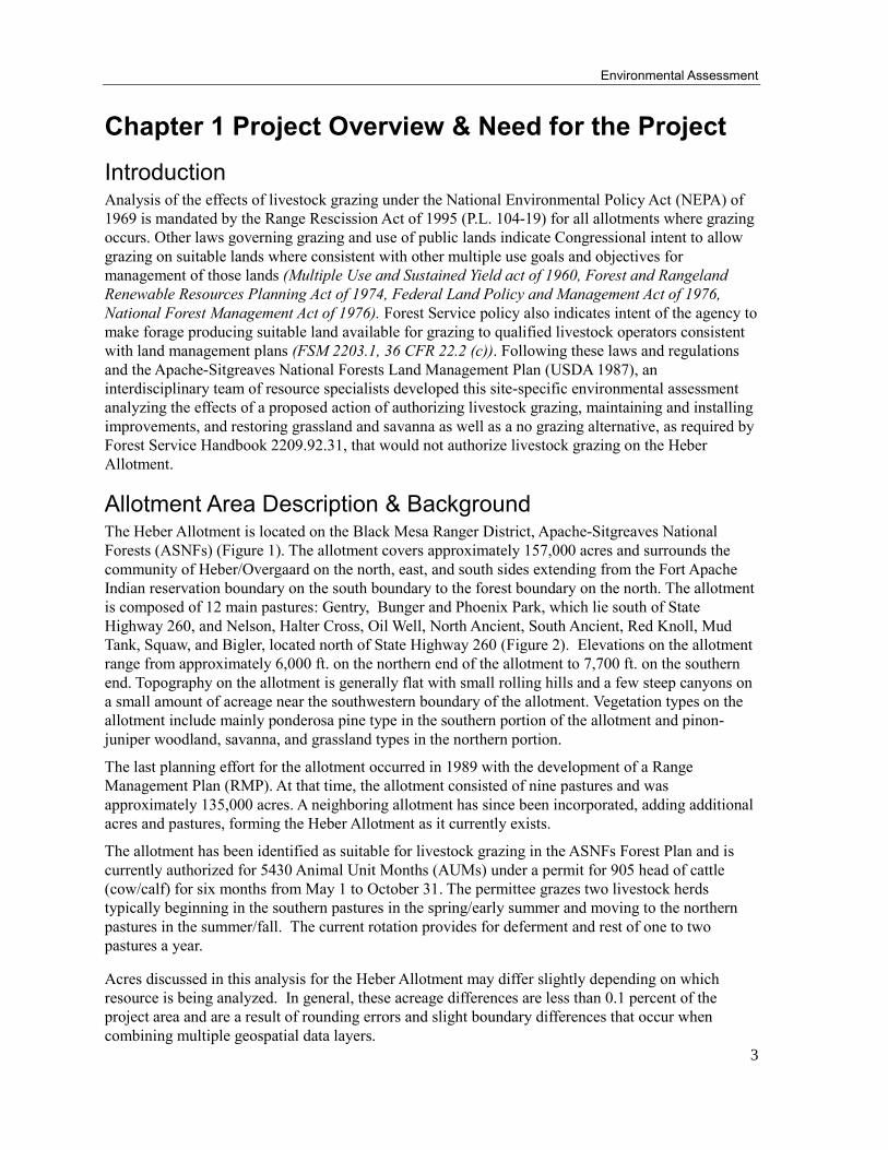
Allotment Area Description & Background The Heber Allotment is located on the Black Mesa Ranger District, Apache-Sitgreaves National
Forests (ASNFs) (Figure 1). The allotment covers approximately 157,000 acres and surrounds the
community of Heber/Overgaard on the north, east, and south sides extending from the Fort Apache
Indian reservation boundary on the south boundary to the forest boundary on the north. The allotment
is composed of 12 main pastures: Gentry, Bunger and Phoenix Park, which lie south of State
Highway 260, and Nelson, Halter Cross, Oil Well, North Ancient, South Ancient, Red Knoll, Mud
Tank, Squaw, and Bigler, located north of State Highway 260 (Figure 2). Elevations on the allotment
range from approximately 6,000 ft. on the northern end of the allotment to 7,700 ft. on the southern
end. Topography on the allotment is generally flat with small rolling hills and a few steep canyons on
a small amount of acreage near the southwestern boundary of the allotment. Vegetation types on the
allotment include mainly ponderosa pine type in the southern portion of the allotment and pinon-
juniper woodland, savanna, and grassland types in the northern portion.
The last planning effort for the allotment occurred in 1989 with the development of a Range
Management Plan (RMP). At that time, the allotment consisted of nine pastures and was
approximately 135,000 acres. A neighboring allotment has since been incorporated, adding additional
acres and pastures, forming the Heber Allotment as it currently exists.
The allotment has been identified as suitable for livestock grazing in the ASNFs Forest Plan and is
currently authorized for 5430 Animal Unit Months (AUMs) under a permit for 905 head of cattle
(cow/calf) for six months from May 1 to October 31. The permittee grazes two livestock herds
typically beginning in the southern pastures in the spring/early summer and moving to the northern
pastures in the summer/fall. The current rotation provides for deferment and rest of one to two
pastures a year.
Acres discussed in this analysis for the Heber Allotment may differ slightly depending on which
resource is being analyzed. In general, these acreage differences are less than 0.1 percent of the
project area and are a result of rounding errors and slight boundary differences that occur when
combining multiple geospatial data layers.
Heber Allotment
4
Figure 1. General Location of Heber Allotment, Black Mesa Ranger District

Environmental Assessment
5
Figure 2. Heber Allotment with Pasture Names
Heber Allotment
6
Purpose and Need for Action Management and monitoring of livestock grazing on the Heber Allotment needs to be analyzed and
updated from the 1989 RMP to provide more flexibility to adapt management to fit conditions of
resources on the allotment as they change and move certain resources on the allotment toward Forest
Plan objectives and desired conditions. Grasslands and savanna understory vegetation in the pinon-
juniper vegetation need to be restored to desired conditions to protect or improve soils and watershed
conditions, enhance forage quality and availability, and help maintain or improve herbaceous
vegetation species diversity and production for the future. NEPA analysis for grazing on the allotment
also needs to be completed to fulfill legal requirements of the Rescission Act of 1995.
Objectives to fulfill the purpose and need of this project include:
Continue to manage vegetation to promote stable to upward trends within key areas and long-
term transect locations
Incorporate flexibility into the management of the Heber Allotment in order to allow the Forest
Service to adapt management to changing resource and environmental conditions.
Reduce canopy cover of pinon-juniper in order to maintain and restore ground cover and
herbaceous vegetation to move towards desired conditions in grassland and woodland areas
Maintain watershed and riparian conditions at levels that are stable or on an upward trend.
Maintain current satisfactory soil conditions and improve soil conditions rated as impaired or
unsatisfactory.
Develop a monitoring plan to verify that management actions are maintaining or moving
resource conditions toward those desired.
Proposed Action In response to the purpose and need, the Black Mesa Ranger District proposes to
1. Authorize livestock grazing on the Heber Allotment to maintain and/or improve vegetation,
soil, and watershed conditions relative to livestock grazing, including
Flexibility to adaptively manage livestock to fit resource and weather conditions as
they change.
Monitoring to ensure that resource conditions are meeting or moving toward
desired conditions
2. Maintain existing improvements and install new improvements needed to provide water and
optimize management and distribution of cattle
3. Mechanically and manually (by hand) remove juniper trees within historical grassland and
savanna woodland areas to restore those areas
4. Prescribe burn grassland and savanna woodland areas to restore and maintain those areas
Apache-Sitgreaves Forest Plan Consistency Management direction is found within the resource prescriptions of the Apache-Sitgreaves National
Forests Land and Resource Management Plan (A-S LRMP), 1987. The Forest Plan’s desired
condition and prescriptions for management occur within Management Area 1, Forested Land;
Management Area 2, Woodland; Management Area 3, Riparian, and Management Area 4,

Environmental Assessment
7
Grasslands. This analysis was developed in consideration of the best available science and is
consistent with the 1987 National Forest Land and Resource Management Plan, as amended.
Decision Framework The Black Mesa District Ranger is the responsible official for this project who will review the
alternatives of no action and the proposed action and the associated environmental consequences to
make a decision. The decision should contain activities that best meet the purpose and need of the
project, provide consistency with forest plan standards and guidelines for resources in the project
area, and comply with applicable laws, regulations, and policies. The District Ranger will decide
whether to
Implement the proposed action as described or with modifications
If modifying the proposed action, specify which design criteria and BMPs to use
Develop an environmental impact statement
Implement the No Action Alternative
Public Involvement The proposal was listed in the ASNFs Schedule of Proposed Actions (SOPA) in January 2014. In July
2014, the Black Mesa Ranger District provided a field trip allowing collaborators to visit various sites
in the proposed project area and review conditions. The purpose of the trip was to discuss the
proposed authorization of grazing and treatment of invading pinon-juniper in grassland and savanna
areas on the allotment. Four people attended.
On August 13, 2014, a scoping package was sent to approximately 59 individuals, groups, and federal
and state agencies. Four public comment letters were received. Four letters from tribes were also
received.
Issues An issue is a point of discussion, debate, or dispute about the environmental effects of the proposed
activities. Issues are cause-effect relationships directly or indirectly caused by implementing the
proposed action. Following our initial scoping process, we reviewed all comments received to
determine if any key issues were identified. Comments were sorted by:
1. Key issues: Issues which are directly or indirectly caused by implementing the proposed
activity that would require development of an alternative to address or resolve them:
2. Issues eliminated from detailed study, which include those that are outside the scope of the
proposed activity; already decided by law, regulation, forest plan, or other higher level
decisions; Irrelevant to the stated decision to be made; or conjectural and not supported by
scientific or factual evidence.
3. Concerns including: requests addressed by comment responses and/or in forthcoming
analyses or correspondence, general questions about the project, and/or interest in documents
and continued correspondence.
4. Supportive comments
5. Neutral comments

Heber Allotment
8
No key issues were identified. Some concerns expressed, including projected costs of rangeland
improvements, are addressed in this assessment. Some comments were eliminated from detailed
study for reasons listed above, some were supportive, and some were neutral.
Environmental Assessment
9
Chapter 2 Alternatives Including the Proposed Action This section provides a comparison of alternatives and defines the differences between each
alternative for the public and to provide a clear basis for choice among options by the decision maker.
The information used to compare the alternatives is based upon the environmental, social, and
economic effects of implementing each alternative.
Alternatives Considered But Eliminated from Detailed Study Federal agencies are required by the National Environmental Policy Act (NEPA) to briefly discuss the
reasons for eliminating any alternatives that were not developed in detail (40 CFR 1502.14).
Alternatives eliminated from detailed study and the rationale for their elimination follows:
Current Management Alternative
According to guidance in the Forest Service Grazing Permit Administrative Handbook (FSH) 2209.13
92.31, “Current management would also be analyzed in detail as an alternative to the proposed action
if current management meets the stated purpose and need for action.” Current management was not
analyzed in detail because it does not fully meet all aspects of the purpose and need. Current
management livestock levels are incorporated into the proposed action as the initial and possibly
continued levels of authorized livestock grazing, so an alternative with current management levels is
not needed as a separate alternative.
Alternatives Considered In Detail
Alternative 1: No Action/No Grazing
Under alternative 1, grazing by domestic livestock on the allotment would not be authorized. The
permittee would be given one year from the date of the decision for the allotment to remove livestock.
Existing improvements contributing to resource protection or enhancement, such as water
developments important for wildlife, may be maintained where feasible through other resource
program areas with use of their funds. Periodic inspection of existing structural improvements would
be made to determine whether maintenance or removal of the improvement is needed. Forest
boundary fences would be maintained by the Black Mesa Ranger District. Existing allotment
boundary fences would remain in place, and maintenance of the allotment boundary fences would be
re-assigned to adjacent grazing permit holders No vegetation treatments would be implemented.
Alternative 2: Proposed Action
The proposed action consists of three major components:
1. Re-authorization of livestock grazing on the Heber Allotment through a new Allotment
Management Plan that includes
A monitoring plan to ensure that desired conditions are being met
Adaptive management strategies to provide flexibility to adjust management to fit
changing resource conditions
2. Structural improvements including maintenance of existing improvements and installation of
new improvements
3. Grassland and pinon-juniper woodland restoration treatments
Heber Allotment
10
Re-authorization of Livestock Grazing
In response to the purpose and need, the Black Mesa Ranger District proposes to re-authorize
livestock grazing on the Heber Allotment under a new Allotment Management Plan (AMP) that
would include strategies for adaptive management of livestock grazing to fit resource conditions as
they change. The proposal would include authorization of a range of AUMs with a maximum of 7,600
AUMs and a six month grazing season from May 1 to October 31 under a deferred, rest rotation
grazing system.
Up to 5,430 AUMs would be authorized for up to six months between May 1 and October 31.
Adjustments that increase the numbers up to 5,430 AUMs could be made annually through the
Annual Operating Instructions (AOI), based on factors like weather or plant health, or if data
collected through implementation monitoring supports an increase. An increase above 5,430 AUMs
may not occur until after three grazing seasons following the decision. For every increase above 5,430
AUMs that is greater than 10%(543 AUMs), the following must occur: 1) effectiveness monitoring
and a review of all monitoring to validate that existing conditions are still within or working toward
the desired conditions and trends are stable to improving and 2) three full grazing season years must
pass before the next 10%(543 AUMs) increase. Adjustments that decrease the numbers could be
made annually through the Annual Operating Instructions, based on factors like weather or plant
health, or if data collected through implementation or effectiveness monitoring warrants a need for
reduction. Any changes to grazing management could include numbers, timing, intensity, or
frequency of grazing. Under this system, every pasture would receive rest once every twelve to
thirteen years with periodic growing season rest and the ability to adjust for rest based on pasture
conditions. Total use at the end of the growing season would generally be maintained within
conservative use levels of 25-35 percent utilization.
Monitoring
Implementation Monitoring
Upland Vegetation: Monitoring would occur the first year following implementation and would be
conducted every year or every other year thereafter as needed and determined upon completion of the
last recent monitoring. Utilization monitoring would occur either during or at the end of the growing
season. Monitoring data would be used to determine if any adjustments in management should be
implemented to allow for plant development, regrowth, and recovery from the grazing event.
Implementation monitoring methods may include, but are not limited to comparative yield, stubble
height, paired plot clipping and weighing, height/weight, Landscape Appearance Method, or
photography. Implementation monitoring may also include review of livestock numbers and dates of
use in each pasture, conditions of range improvements, and compliance with the AOI.
Riparian: Proposed use guidelines for riparian components are as follows: obligate riparian tree
species-limit use to 20% use by weight of palatable riparian tree species; or <50 percent of terminal
leaders (top one third of the plant) on palatable riparian tree species accessible to livestock (usually ≤
6 feet tall); deergrass – minimal stubble height of 8 inches where key species; emergent species
(rushes, sedges, cattails, and horsetails)-maintain six to eight inches of stubble height during the
grazing period where key species; stream banks – limit use to ˂ 20 percent of alterable banks where
stream banks are present or forming. Once riparian utilization guidelines are met, cattle would be
moved from the area or to the next scheduled pasture regardless of available forage in the uplands.
Effectiveness Monitoring
Upland vegetation: Monitoring would be used to assess the effectiveness of management in achieving
desired objectives in relation to species composition, ground cover, and trends. This monitoring
would occur in the sites described within the EA (ex. NATT1, Phoenix Park C4). Effectiveness
monitoring methods may include, but are not limited to Parker 3-step, frequency, dry-weight rank,

Environmental Assessment
11
Common Non-Forested Vegetation Sampling Protocol (CNVSP), Daubenmire, and/or photography.
Depending on the method selected, monitoring would occur at an interval of at least every 5-10 years
in established areas.
Soil Condition Monitoring for Impaired Soil Conditions Not Receiving Vegetation Treatments: Some
small, localized special extents TES map units 52 were identified across the northern portion of the
allotment during the analysis process, particularly in the northwestern portion of the Oil Well pasture
and the southeastern portion of Red Knoll, where current soil conditions are in a less than desired or
impaired state (USDA-FS, 2013; 1999).
Riparian Monitoring: Monitoring would include at least three riparian designated monitoring areas
(DMAs). Initially, one DMA each would be established in Black Canyon, Pierce Wash, and Phoenix
Park Wash drainages. Additional DMAs could be added later or relocated along these or other
streams as necessary. Effectiveness monitoring would also be conducted in the riparian DMAs. This
monitoring would include use of Multiple Indicator Monitoring (MIM) (Burton et al. 2011), a
modification of the method, or the most current acceptable method. Effectiveness monitoring should
occur every 3-5 years or when the aforementioned AUM increase criteria are met. PFC assessments
would be the critical determinate of riparian condition trend and should be conducted in conjunction
with upland vegetation effectiveness monitoring.
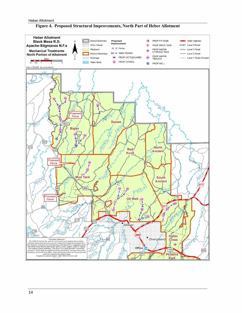
Structural Improvements
Existing improvements should be maintained to further promote proper management and achievement
of objectives. The following list of proposed improvements would aid in the achievement of desired
conditions (Figures 3 &4):
Drill 1 new well
Add approximately 9 ¼ miles of pipeline to existing wells and 1 new well
Install 14 troughs and 2 storages on the new pipelines from the wells
Install 2 new cattleguards and re-locate 1 existing cattleguard
Construct 7 new waterlots and 8 new corrals
Construct 16 new roadside stock tanks
Create 2 new holding pastures
Expand 1 trick tank and build 4 new trick tanks
Install 14 new troughs and 7 ¾ miles of pipe on the new trick tanks


Environmental Assessment
13
Figure 3. Proposed Structural Improvements, South Part of Allotment
Heber Allotment
14
Figure 4. Proposed Structural Improvements, North Part of Heber Allotment

Environmental Assessment
15
Grassland and Pinon-Juniper Woodland Restoration Treatments
Mechanical treatments are proposed within the northern eight pastures (Figure 5) north of Highway
260 totaling approximately 39,000 acres. Approximately 17,800 acres would be treated for
restoration of grasslands and approximately 21,200 of woodland would be thinned to reduce canopy
cover and restore understory vegetation (Table 1, Figure 5). Methods for implementation of the
treatments may include mastication, whole tree removal using heavy equipment, personal and
commercial fuelwood sales, tree shearing, and hand thinning. Prescribed burning may be used to
restore and maintain grasslands and woodland areas and improve understory vegetation across the
allotment. No treatment for removal of ponderosa pine would occur.
Table 1. Treatment type by acres and percentage of total
Treatment Type Desired Canopy
Cover Percent Treatment Acres Percentage of Total
Grassland Restoration <10% 17,758 22%
Woodland Thinning 10-20% 21,196 26%
No Treatment 20%+ 42,379 52%
Total 81,333 100%
Grassland Restoration: These areas have been identified generally as areas that were historically
grasslands where the herbaceous understory made up more of the composition than the woody
overstory. The goal for this type of treatment is to reduce the canopy cover of pinon and juniper tree
species to less than 10%.
Woodland Thinning: These areas have been identified as woodland stands that were historically more
open, providing for a diverse mix of overstory and understory vegetation structure. The majority of
these stands are currently between 35 and 50% canopy cover. The goal for this type of treatment is to
retain between 10% and 20% canopy cover of pinon-juniper.

Heber Allotment
16
Figure 5. Proposed Vegetation Treatments

Environmental Assessment
17
Transportation for Vegetation Treatments
All access to vegetation treatment areas would occur on existing system roads. The following miles
of existing system roads have been identified as potential for use for vegetation treatment activities in
the northern portion of the allotment (these numbers may vary by up to 10%):
Table 2. Roads by Maintenance Level and Miles
Maintenance Level Miles
1 54
2 125
3 17
Total Miles 196
Maintenance Level 1- closed roads, may be opened and closed after use
Maintenance Level 2 - roads only suitable for high clearance vehicles
Maintenance Level 3 - low speed, single lane roads
Temporary roads may be needed for implementation of vegetation treatments in order to avoid
cultural resources, comply with the Clean Water Act, or other circumstances. Temporary roads would
be needed to complete treatments and would be closed and rehabilitated following use. No new
permanent road construction would occur. In addition to the closing of the temporary roads,
unauthorized roads and ATV trails that are within impaired soils would be closed and rehabilitated.
Summary
Table 3.General Alternatives Comparison
Alternative 1 Alternative 2
Animal Unit Months 0 up to 7,600
Season of Use 0 05/01 – 10/31
Proposed Structural Improvements
Wells 0 1
Pipeline 0 17 miles
Water Troughs 0 28
Water Storages 0 2
Trick Tanks 0 4 new, 1 expansion
Stock Tanks 0 16
Waterlots 0 7
Corrals 0 8
Holding Pastures 0 2
Cattleguards 0 2 new, 1 move
Vegetation Treatments(acres)
Grassland Restoration 0 17,758
Savanna Thinning 0 21,196
Heber Allotment
18
Chapter 3 Affected Environment & Environmental Impacts of the Proposed Action and Alternatives
Range/Vegetation
Affected Environment
Livestock Grazing The allotment is currently permitted for 905 head of cattle (cow/calf) for six months from May 1 to
October 31 (5430 Animal Unit Months (AUMs)). The current allotment is composed of 12 main
pastures. Livestock grazing occurs in two different herds typically beginning in the southern pastures
in the spring/early summer and moving to the northern pastures in the late summer/fall. The current
rotation provides for deferment and rest of one to two pastures a year.
Vegetative trends and attributes, such as species composition and ground cover were measured using
methods such as the Parker 3-step and the Common Non-Forested Vegetation Sampling Protocol
(CNVSP). Six Parker 3 step sites currently show stable trends and of the 11 CNVSP sites, 3 have an
upward trend and 8 were rated as stable with no trend. These 17 sites are proposed for future
monitoring locations.
Utilization measurements have been collected since 2002 in 9 of the 12 pastures (all north of
Highway 260), with the exception of 2011. The Gentry, Bunger, and Phoenix Park pastures have had
utilization measurements performed since 2007.
Table 4. Summary of actual use since 2001 and overall average utilization of all measurements
since 2002 or 2007.
Pasture Actual Use
(AUM’s)
Average Utilization
(%)
North Ancient 80 to 304 5
South Ancient 70 to 304 12
Oil Well 160 to 568 12
Red Knoll 80 to 349 8
Mud Tank 241 to 465 8
Squaw 133 to 621 8
Bigler 167 to 705 4
Halter Cross 160 to 605 5
Nelson 292 to 732 22
Gentry 579 to 1017 15
Bunger 597 to 1017 11
Phoenix Park 460 to 843 11
Vegetation Over 90% of the allotment is made up of three vegetation types: ponderosa pine, pinon-juniper
woodland, and Great Basin grassland. The remainder of the allotment is made up of mixed conifer,
oak woodland, dry streams, wetlands, reservoirs, or rock pits. The majority of the Nelson, Gentry,
Bunger, and Phoenix Park Pastures consist of ponderosa pine while the remainder of the pastures is
mainly pinon-juniper woodland and Great Basin grassland. Desired conditions for vegetation
treatments were derived using aerial photos, site visits, specialist’s knowledge of the area, existing
cover types, and Potential Natural Vegetation Types (PNVT).
Environmental Assessment
19
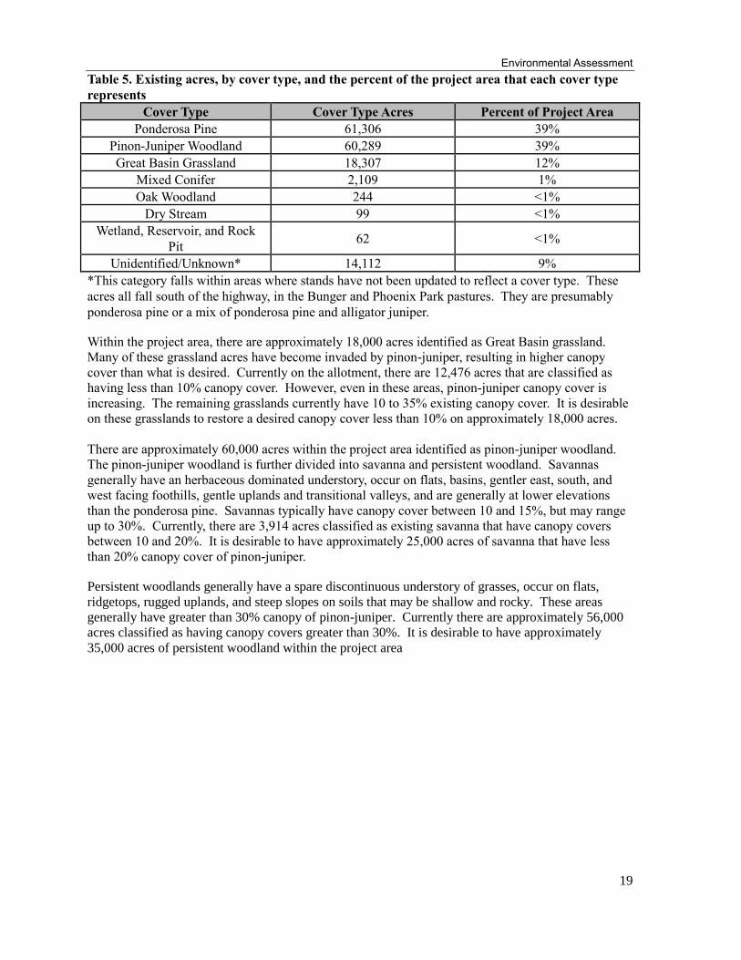
Table 5. Existing acres, by cover type, and the percent of the project area that each cover type
represents
Cover Type Cover Type Acres Percent of Project Area
Ponderosa Pine 61,306 39%
Pinon-Juniper Woodland 60,289 39%
Great Basin Grassland 18,307 12%
Mixed Conifer 2,109 1%
Oak Woodland 244 <1%
Dry Stream 99 <1%
Wetland, Reservoir, and Rock
Pit 62 <1%
Unidentified/Unknown* 14,112 9%
*This category falls within areas where stands have not been updated to reflect a cover type. These
acres all fall south of the highway, in the Bunger and Phoenix Park pastures. They are presumably
ponderosa pine or a mix of ponderosa pine and alligator juniper.
Within the project area, there are approximately 18,000 acres identified as Great Basin grassland.
Many of these grassland acres have become invaded by pinon-juniper, resulting in higher canopy
cover than what is desired. Currently on the allotment, there are 12,476 acres that are classified as
having less than 10% canopy cover. However, even in these areas, pinon-juniper canopy cover is
increasing. The remaining grasslands currently have 10 to 35% existing canopy cover. It is desirable
on these grasslands to restore a desired canopy cover less than 10% on approximately 18,000 acres.
There are approximately 60,000 acres within the project area identified as pinon-juniper woodland.
The pinon-juniper woodland is further divided into savanna and persistent woodland. Savannas
generally have an herbaceous dominated understory, occur on flats, basins, gentler east, south, and
west facing foothills, gentle uplands and transitional valleys, and are generally at lower elevations
than the ponderosa pine. Savannas typically have canopy cover between 10 and 15%, but may range
up to 30%. Currently, there are 3,914 acres classified as existing savanna that have canopy covers
between 10 and 20%. It is desirable to have approximately 25,000 acres of savanna that have less
than 20% canopy cover of pinon-juniper.
Persistent woodlands generally have a spare discontinuous understory of grasses, occur on flats,
ridgetops, rugged uplands, and steep slopes on soils that may be shallow and rocky. These areas
generally have greater than 30% canopy of pinon-juniper. Currently there are approximately 56,000
acres classified as having canopy covers greater than 30%. It is desirable to have approximately
35,000 acres of persistent woodland within the project area
Heber Allotment
20
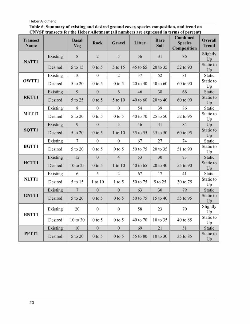
Table 6. Summary of existing and desired ground cover, species composition, and trend on
CNVSP transects for the Heber Allotment (all numbers are expressed in terms of percent)
Transect
Name
Basal
Veg Rock Gravel Litter
Bare
Soil
Combined
Species
Composition
Overall
Trend
NATT1
Existing 8 2 5 56 31 86 Slightly
Up
Desired 5 to 15 0 to 5 5 to 15 45 to 65 20 to 35 52 to 90 Static to
Up
OWTT1
Existing 10 0 2 37 52 81 Static
Desired 5 to 20 0 to 5 0 to 5 20 to 40 40 to 60 60 to 90 Static to
Up
RKTT1
Existing 9 0 6 46 38 66 Static
Desired 5 to 25 0 to 5 5 to 10 40 to 60 20 to 40 60 to 90 Static to
Up
MTTT1
Existing 8 0 0 54 39 86 Static
Desired 5 to 20 0 to 5 0 to 5 40 to 70 25 to 50 52 to 95 Static to
Up
SQTT1
Existing 9 0 5 46 41 84 Up
Desired 5 to 20 0 to 5 1 to 10 35 to 55 35 to 50 60 to 95 Static to
Up
BGTT1
Existing 7 0 0 67 27 74 Static
Desired 5 to 20 0 to 5 0 to 5 50 to 75 20 to 35 51 to 90 Static to
Up
HCTT1
Existing 12 0 4 53 30 73 Static
Desired 10 to 25 0 to 5 1 to 10 40 to 65 20 to 40 55 to 90 Static to
Up
NLTT1
Existing 6 5 2 67 17 41 Static
Desired 5 to 15 1 to 10 1 to 5 50 to 75 5 to 25 30 to 75 Static to
Up
GNTT1
Existing 7 0 0 63 30 79 Static
Desired 5 to 20 0 to 5 0 to 5 50 to 75 15 to 40 55 to 95 Static to
Up
BNTT1
Existing 20 0 0 58 23 70 Slightly
Up
Desired 10 to 30 0 to 5 0 to 5 40 to 70 10 to 35 40 to 85 Static to
Up
PPTT1
Existing 10 0 0 69 21 51 Static
Desired 5 to 20 0 to 5 0 to 5 55 to 80 10 to 30 35 to 85 Static to
Up
Environmental Assessment
21
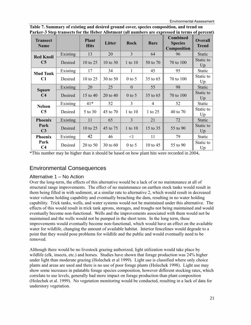
Table 7. Summary of existing and desired ground cover, species composition, and trend on
Parker-3 Step transects for the Heber Allotment (all numbers are expressed in terms of percent)
Transect
Name
Plant
Hits Litter Rock Bare
Combined
Species
Composition
Overall
Trend
Red Knoll
C5
Existing 13 20 3 64 96 Static
Desired 10 to 25 10 to 30 1 to 10 50 to 70 70 to 100 Static to
Up
Mud Tank
C1
Existing 17 34 1 45 95 Static
Desired 10 to 25 30 to 50 0 to 5 35 to 65 70 to 100 Static to
Up
Squaw
C4
Existing 20 25 0 55 98 Static
Desired 15 to 40 20 to 40 0 to 5 35 to 65 70 to 100 Static to
Up
Nelson
C5
Existing 41* 52 3 4 52 Static
Desired 5 to 30 45 to 70 1 to 10 1 to 25 40 to 70 Static to
Up
Phoenix
Park
C3
Existing 11 65 3 21 72 Static
Desired 10 to 25 45 to 75 1 to 10 15 to 35 55 to 90 Static to
Up
Phoenix
Park
C4
Existing 42 46 <1 11 79 Static
Desired 20 to 50 30 to 60 0 to 5 10 to 45 55 to 90 Static to
Up
*This number may be higher than it should be based on how plant hits were recorded in 2004.
Environmental Consequences
Alternative 1 – No Action Over the long-term, the effects of this alternative would be a lack of or no maintenance at all of
structural range improvements. The effect of no maintenance on earthen stock tanks would result in
them being filled in with sediment, at a similar rate to alternative 2, which would result in decreased
water volume holding capability and eventually breaching the dam, resulting in no water holding
capability. Trick tanks, wells, and water systems would not be maintained under this alternative. The
effects of this would result in trick tank aprons, storages, and troughs not being maintained and would
eventually become non-functional. Wells and the improvements associated with them would not be
maintained and the wells would not be pumped in the short term. In the long term, these
improvements would eventually become non-functional, which would have an effect on the available
water for wildlife, changing the amount of available habitat. Interior fencelines would degrade to a
point that they would pose problems for wildlife and the public and would eventually need to be
removed.
Although there would be no livestock grazing authorized, light utilization would take place by
wildlife (elk, insects, etc.) and horses. Studies have shown that forage production was 24% higher
under light than moderate grazing (Holechek et al 1999). Light use is classified where only choice
plants and areas are used and there is no use of poor forage plants (Holechek 1998). Light use may
show some increases in palatable forage species composition, however different stocking rates, which
correlate to use levels, generally had more impact on forage production than plant composition
(Holechek et al. 1999). No vegetation monitoring would be conducted, resulting in a lack of data for
understory vegetation.
Heber Allotment
22
The northern pastures (Bigler, Squaw, Mud Tank, Red Knoll, North Ancient, South Ancient, Oil Well,
and Halter Cross), currently dominated by blue grama, may experience an increase in production of
blue grama, but likely would not see much change in species composition as a result of removing
livestock. A general slight increase in ground cover, resulting from increased production, may be
expected in the short term. Under light stocking, upward trends have been seen in ecological
condition (Holechek 1999). The upward degree of these trends was not classified in that study. In the
long term, without vegetation treatments, these increases in production, ground cover, and trends
would begin to diminish as a result of increasing overstory canopy cover. Dense stands of even aged
trees can dominate a site so that the soil surface is largely barren of understory grasses and forbs.
Displacement of understory plants by juniper resulted in a loss of 70 percent of the perennial grasses,
forbs, and half-shrubs in an ungrazed study plot (USDA 1964). Species composition changes would
likely be more related to the overstory juniper increase rather than the removal of livestock.
For the southern pastures (Nelson, Gentry, Bunger, and Phoenix Park), which are dominated by
understory species more closely related to the ponderosa pine type, light use levels would still be
expected, but may be slightly higher based on a more prominent elk population. In the ponderosa
pine type, lightly grazed areas generally showed more abundant flower stalks and seed heads than
moderately grazed areas. Light grazing provided for the best vigor, slightly above moderate grazing
levels, and herbage production of mountain muhly and Arizona fescue, when compared to moderate
and heavy grazing. Even in lightly grazed pastures, areas of heavy and moderate grazing may occur
(Johnson 1953). Under Alternative 1, there would still be areas that receive concentrated use by
wildlife, even with the removal of livestock. These areas would likely be more preferable areas, like
open timber stands and drainage bottoms that produce desirable forage species. Ponderosa pine tends
to increase with the removal of domesticated livestock in these ponderosa pine dominated sites.
According to studies on New Mexico Forests, ponderosa pine had a greater increase under protection
from grazing than when grazed. Where protection from grazing had been provided, dense coverages
of pine seedlings developed (Potter and Krenetsky 1967). Under Alternative 1, increases in vigor and
production of some species can be expected, while blue grama may decrease in vigor and production.
Ground cover could increase, resulting from increased production and vigor, which may result in
slightly upward trends. In the long term, without the presence of livestock grazing, ponderosa pine
would continue to increase. Increases in ponderosa pine canopy would decrease the production of
understory vegetation by producing more needle cast and limiting the amount of light and water that
reaches the forest floor. The amount of light reaching the forest floor is the most influential and
manageable variable affecting understory forage production. Dense forest canopies, resulting under
Alternative 1, intercept significant snow and rainfall throughout the year. Most of the intercepted
precipitation evaporates directly into the atmosphere thereby reducing the amount of water reaching
plant roots (Kolb 1999). In these southern pastures, ground cover would be expected to increase,
mainly provided by pine needles, instead of basal coverages provided from native perennial grasses.
Trends would likely decline as understory forage is replaced by ponderosa pine canopy and needle
cast. Species composition of existing forage plants would decline as canopy cover and competition
for resources increases.
Alternative 2
Livestock grazing on the allotment would be authorized and would continue under issuance of a new
term grazing permit. Under the new permit, a range of numbers would be authorized up to 7,600
AUM’s and a six month grazing season (May 1 to October 31) under a deferred, rest rotation grazing
system. Conservative stocking levels would result in utilization between 25 and 35%. A new
allotment management plan would be developed to include adaptive management strategies. A
monitoring plan for both implementation and effectiveness monitoring would be developed as part of
the allotment management plan. New structural range improvements would be developed under this

Environmental Assessment
23
alternative. Vegetation treatments that include pinon-juniper grassland restoration and savanna
thinning would occur under this proposal.
A monitoring plan would be developed under this alternative to evaluate conditions moving toward
desired conditions. The monitoring plan would include implementation and effectiveness monitoring.
Implementation monitoring would be used to determine if any adjustments in management should be
implemented to allow for plant development, regrowth, and recovery from the grazing event.
Effectiveness monitoring would be used to assess the effectiveness of management in achieving
desired objectives. Short term effects of livestock grazing would be tracked through implementation
monitoring and long term effects would be tracked through effectiveness monitoring.
The effects of livestock grazing at the proposed conservative levels (25-35% utilization) would
maintain or even improve the density, composition, vigor, and production of desirable forage plants
within areas that have or would have less than 20% canopy cover(grasslands and savannas).
Increases in these attributes would also have a positive effect on ground cover and trends, likely
increasing at a minimum or improving both. Areas that have greater than 20% canopy(persistent
woodlands), and would not receive any treatment would produce the same amount of grass and forbs,
with maybe a slight decline in production of understory vegetation in the long term. In these areas,
ground cover, species composition, and trends are expected to stay the same. Livestock grazing
would have little effect on these areas with greater than 20% canopy, compared to the effects created
by the overstory component. In these areas, the amount of understory vegetation may be controlled
by the tree overstory and may not reflect grazing effects (Arnold 1964). A seasonal deferred, rest
rotation grazing system would allow for varied timing of grazing among plants. This allows for
different plants to be grazed at different growth stages within any given year and from year to year.
In the long term, combined with other management factors, this grazing system would help promote a
healthy understory of desirable forage species. Across all studies in a Holechek paper, forage
production was 7% higher under rotation compared to continuous grazing and has shown to be more
beneficial to desirable forage species (Holechek 1999). Adaptive management strategies built into
the allotment management plan would allow for greater flexibility in timing, intensity, numbers, etc.
These strategies allow for a greater level of management, increasing efficiency and effectiveness of
management for both the Forest Service and the livestock operator. Strategies are further described in
the adaptive management section of this report.
Livestock grazing at the proposed levels would not be contingent upon completion of any of the
identified proposed range improvements. Proposed management levels are based upon existing
conditions and current historical data. Should these improvements be completed, utilization in key
areas may decrease, indicating that stocking levels are either appropriate or need to be adjusted within
levels specified in this analysis. Proposed structural range improvements would enhance livestock
and vegetation management, promote better livestock distribution and make handling livestock more
efficient, resulting in movement toward management objectives, including a positive effect on ground
cover, species composition, and trends. New improvements identified under Alternative 2 include:
Waters: (1 well, 17 miles of pipeline, 28 water troughs, 2 water storages, 4 new trick tanks and 1
expansion, and 16 new stock tanks)
These improvements deal mainly with either the improvement of existing water sources or the
development of new water sources, with the objective of trying to establish more permanent water
sources on the allotment. The addition of these more permanent water sources would aid in livestock
distribution and overall use of the allotment, allowing for more flexible management practices. These
waters would help in areas that are currently lacking water. This would spread out livestock
distribution and make more efficient use of the available forage. Some disturbance would occur
during installation and some additional trailing, compaction, loss of ground cover and species may
occur around these areas (typically less than 5 acres). There also may be some localized trampling of

Heber Allotment
24
plants during the implementation phase of these projects, but the effects to the plant community
would be of minimal scale and of short duration.
Livestock Handling: (7 waterlots, 8 corrals, 2 holding pastures, 2 new cattleguards and re-locate
one)
These improvements deal with the actual on the ground livestock handling and gathering. These
improvements increase efficiency in livestock handling, allowing for a greater level of management
to be implemented. Waterlots allow the permittee to close waters off, which allows for a different
part of the pasture to be utilized that may not have received use otherwise. Waterlots also provide for
the capability to hold livestock for a short time for livestock management purposes. More corrals
help with handling livestock, whether they are being moved from pasture to pasture, branding or
doctoring animals, or being counted. Holding pastures allow for livestock to be placed in an area that
is smaller than the main pasture for management activities and ease of movement between pastures.
Cattleguards would replace gates that are on roads that receive higher than normal public use, which
presents the opportunity for gates to be left open and allow for livestock to enter another pasture.
Cattleguards would prevent cattle from moving between pastures due to gates being left open. Some
disturbance would occur during installation and some additional trailing, compaction, loss of ground
cover and species may occur around these areas (typically less than 5 acres). There also may be some
localized trampling of plants during the implementation phase of these projects, but the effects to the
plant community would be of minimal scale and of short duration, with positive long term effects
outweighing the negative short term effects.
Vegetation Treatments: (17,758 acres of grassland restoration, 21,196 acres of savanna thinning)
These vegetation treatments are proposed to decrease the overall canopy cover of pinon-juniper
canopy. More than one treatment may be needed to accomplish the desired outcomes. A reduction in
canopy cover would result in increased understory vegetation with greater production, vigor, ground
cover, and species composition. Herbage production in open pinon-juniper stands may be as much as
six times higher than dense pinon-juniper stands (Clary 1986). Grassland restoration treatments
would result in canopy cover less than 10%. These grassland areas would show a greater increase in
attributes associated with increased understory vegetation and would improve livestock distribution
more so than the untreated areas, if climate and soil types are appropriate. In Arizona, an increase of
tree canopy cover from 0 to 10% can reduce herbage production by as much as 50% while additional
increases in canopy cover have comparatively modest effects on herbage production (Clary 1986). In
a study done by Clary and Jameson (1981), the proportion of grasses by weight in the post-treatment
composition increased to 73% from a pretreatment average of 46%. The most prominent species was
blue grama with about 24% of the post-treatment production. Blue grama, which has a reputation of
low productivity and was not expected to respond greatly to pinon-juniper removal, increased
approximately 11 times (Clary and Jameson 1981). Western wheatgrass, a cool season grower,
responds rapidly to the removal of pinon and juniper, particularly on heavy swale soils, where it is a
prominent part of the understory vegetation (Arnold 1964). The extra production in forage, more so
on native perennial grasses than forbs, associated with grassland vegetation treatments would allow
for greater flexibility in management.
Savanna thinning treatments would result in canopy cover of pinon-juniper between 10 and 20%.
These savanna thinning areas would show an increase in herbaceous understory vegetation in terms of
production, species diversity, vigor, and litter accumulation, but at slightly lower levels than grassland
treatments. Mechanical methods used to remove the vegetation would disturb the soil and remove
some of the vegetation in the short term, generally 1-2 years. In general, after two years of summer
rainfall, soils should be stabilized and vegetation production, ground cover, and species composition
would have surpassed pre-treatment levels, based on results for similar treatments done on the Black
Mesa Ranger District in the last decade. Arnold’s study in 1964, shows that herbage production

Environmental Assessment
25
increased until about 10 years after treatment, from 198 lbs/acre before juniper control to about 690
lbs/acre ten years after treatment. He noted that maximum herbage production probably occurs 5 to
10 years after treatment (Arnold 1964). Landing areas associated with processing the removed
material may take longer to recover, but are small in scale to the overall treatment area. Landing
areas may be ripped and seeded if needed. Vegetation treatments would maintain or improve ground
cover, species composition of desirable forage species, and overall trends in grasslands and savannas.
Table 8. Existing and proposed acres for grassland, savanna woodland, and persistent woodland
vegetation types under Alternative 2
Pasture
Existing
Grassland
(acres)
Proposed
Grassland
(acres)
Existing
Savanna
Woodland
(acres)
Proposed
Savanna
Woodland
(acres)
Existing
Persistent
Woodland
(acres)
Proposed
Persistent
Woodland
(acres)
North and South
Ancient 874 1,260 378 2,955 8,828 5,867
Oil Well 101 753 805 6,493 11,514 5,175
Red Knoll 2,117 2,449 404 1,297 6,917 5,691
Mud Tank 219 610 345 3,863 9,166 5,263
Squaw 3,318 4,709 234 298 7,703 6,248
Bigler 4,687 6,409 1,247 4,159 10,503 5,868
Halter Cross 1,160 1,568 501 2,131 4,563 2,571
Total 12,476 17,758 3,914 21,196 59,194 36,683
% of Total Area
(81,333 acres) 17% 23% 5% 28% 78% 48%
Grassland = <10% Canopy Cover
Savanna Woodland = 10-20% Canopy Cover
Persistent Woodland = 20+% Canopy Cover
Effects of Livestock Grazing Under alternative 2, conservative utilization levels (25 to 35%) are being proposed. Conservative use
levels are generally lower than moderate levels but higher than light levels. Moderate grazing
(generally up to 50%) means a degree of herbage utilization that allows the palatable species to
maintain themselves but usually does not permit them to improve in herbage producing ability. Light
grazing (generally up to 25%) means a degree of herbage utilization that allows palatable species to
maximize their herbage producing ability (Holechek 1999). Conservative use levels have shown to
provide benefits from both levels of utilization, with the greatest benefit of light or conservative
stocking in terms of forage production occurring in dry years (Holechek 1999). Most of the studies
available are in terms of light, moderate, or heavy grazing, so for this report, an assumption must be
made that data presented for moderate grazing levels could have had up to 50% utilization, whereas
Alternative 2 proposes levels of 25-35%. Holechek (1999) also stated that different stocking rates
generally had more impact on forage production rather than plant composition, although stocking
rates can influence species composition.
For the northern pastures (Bigler, Squaw, Mud Tank, Red Knoll, North Ancient, South Ancient, Oil
Well, and Halter Cross), blue grama makes up the majority of the species composition. Under
Alternative 2, blue grama would continue to dominate the northern pastures, with a small amount of
other desirable grass species making up the remainder of the composition. In a study completed by
Schuster in 1964 comparing grazing intensities to root development, he found that blue grama and
other grasses had a higher percentage of ground cover and composition in moderately grazed areas

Heber Allotment
26
than in exclosures which excluded livestock. A similar study completed on a high elevation grassland
near Flagstaff, AZ (Loeser et al 2007), showed similar results. That study showed that cattle removal
demonstrated no consistent differences in cover from the moderate grazing control in any plant
functional category. This study also showed that native species richness, which is correlated to
species composition, in the moderately grazed treatment was greater or similar to that in cattle
removal plots, even in dry years. Under Alternative 2, species composition should remain similar or
increase compared to what is existing currently. Ground cover should remain relatively stable, with
no major changes likely to take place. Trends on long term transects should remain stable or improve
under the actions proposed in Alternative 2. It is likely that more influence on ground cover, species
composition, and trends is provided by overstory canopy cover rather than livestock grazing.
For the southern pastures (Nelson, Gentry, Bunger, and Phoenix Park), which are more dominated by
ponderosa pine rather than pinon-juniper, effects from livestock grazing are similar to the northern
pastures, but would vary slightly in species composition and ground cover. Similar to the northern
pastures, it is more likely that species composition, ground cover, and trend would be more influenced
by overstory vegetation rather than livestock grazing. Potter and Krenetsky (1967) actually found
that ponderosa pine had a greater increase under protection than when grazed and found that dense
coverages of pine seedlings developed in the areas protected from grazing. Based on this data,
Alternative 2 should help to slow down some of the ponderosa pine regeneration, which has a major
influence on understory vegetation, that occurs in these pastures. Herbage production increased on
the moderately and lightly grazed grassland and was maintained on the moderately and lightly grazed
open timber (Johnson 1953). Vigor of Arizona fescue and mountain muhly would remain the same
under the use levels proposed under Alternative 2 (Johnson 1953). In conclusion, Alternative 2 would
maintain or improve production and vigor of desirable perennial grass species in the ponderosa pine
type. Species composition should remain similar to existing conditions, as well as ground cover and
trends under the proposed management activities.

Environmental Assessment
27
Table 9. Alternatives Comparison by Pasture
Pasture Proposed Structural Improvements
Proposed Grassland/Savanna Treatment Acres (%
of pasture)
Result in Long Term Trend*
Alt. 1 Alt. 2 Alt. 1 Alt. 2 Alt. 1 Alt. 2
North and South Ancient
None 1 waterlot
1 corral 0
4,215 (41%)
→ or ↘ → or ↗
Oil Well None
5 ¾ miles of pipe 7 troughs 1 storage
1 trick tank
0 7,246 (53%)
→ or ↘ → or ↗
Red Knoll None 1 cattleguard
Re-locate 1 cattleguard 0
3,746 (39%)
→ or ↘ → or ↗
Mud Tank None
2 corral expansions 2 waterlots
1 trick tank expansion 1 new trick tank 1 ½ miles of pipe
5 troughs
0 4,473 (34%)
→ or ↘ → or ↗
Squaw None 1 mile of pipe
1 trough 0
5,007 (45%)
→ or ↘ → or ↗
Bigler None
1 well 8 ½ miles of pipe
8 troughs 1 storage 1 waterlot
1 corral
0 10,568 (66%)
→ or ↘ → or ↗
Halter Cross None
2 stock tanks 1 trick tank 4 troughs
2 ¼ miles of pipe
0 3,699 (50%)
→ or ↘ → or ↗
Nelson None 1 holding pasture 0 0 → →
Gentry None
1 cattleguard 1 holding pasture
3 stock tanks 1 corral
1 waterlot
0 0 → →
Bunger None 4 stock tanks 2 waterlots
0 0 → or ↗ → or ↗
Phoenix Park None
5 stock tanks 1 corral expansion
2 corrals 1 holding trap
1 trick tank 1 ¼ miles of pipe
3 troughs
0 0 → →
*based on 6 Parker 3-Steps and 11 CNVSP transects → - stable with no apparent trend ↗ - upward trend ↘ - downward trend

Heber Allotment
28
Cumulative Effects
Past Activities The past activities are as follows: Broadcast Burning, Pile Burning, Timber Cuts,
Compacting/Crushing of Fuels, Fuel Break, Noxious Weed Treatments, Piling, Chipping,
Rearrangement of Fuels, Wildfires (such as Rodeo-Chediski and the Potato), Tree Planting, Grazing,
Range Forage Improvement, Tree Encroachment Control, Non-Structural Watershed Improvements,
Pinon-Juniper Removal, and Wildlife Habitat Improvement. In general, these past activities have had
a cumulative effect on existing conditions. The vegetation and landscape that is present within the
Heber Allotment is a result of these activities, along with several other factors. These activities have
generally provided a benefit to the range and vegetation portions of the allotment.
Present and Reasonably Foreseeable Activities Rodeo-Chediski Prescribed Burn – An environmental analysis was completed in 2012 that
analyzed prescribed burning in the Rodeo-Chediski fire. This activity should reduce ponderosa pine
regeneration and restore vigor in herbaceous understory vegetation. Prescribed burning, depending
on the scale, could impact pasture rotations, livestock distribution, and overall livestock productivity.
Mexican Gray Wolf Recovery Plan – A Record of Decision was signed January 2015 for a revision
to the regulations regarding the gray wolf. This revision expanded the territory to include the
Sitgreaves National Forest, which includes the Heber Allotment. It also allows for the release of
wolves on the Sitgreaves. The presence of wolves on the Heber Allotment could impact pasture
rotations, livestock, distribution, and livestock productivity.
Heber Wild Horse Territory – The Heber Wild Horse Territory (HWHT) is approximately 20,000
acres, entirely on the Black Mesa Ranger District. Approximately 9,349 acres of the HWHT overlaps
the Heber Allotment, mainly within the Gentry Pasture (7,326 acres), with the remainder in the
Bunger Pasture (1,892 acres), and the Holding Pasture (131 acres). The HWHT is currently
undergoing analysis, with no current proposed action developed at this time. As part of the NEPA
process, a management plan for the HWHT would be developed which would result in the
development of an Appropriate Management Level (AML).
OHV Trails and Use – In the project area, there are numerous OHV trails and routes. Unauthorized
OHV use can decrease production and ground cover. OHV use can also impact long term monitoring
transects by reducing vegetation and potentially destroying the transect location itself. The effects of
OHV use are minor in scale when compared to the total project area.
Watershed & Soils
Affected Environment
Air Quality
The ASNFs management activities do not appreciably contribute to the increase of the six pollutants
identified by the EPA, except for particulate matter. The primary source of particulate matter from the
forests comes from road and fugitive1 dust and emissions from smoke, contributing to regional haze.
The forests also contribute emissions from motor vehicles. Five Class 1 airsheds are identified within
a 80 mile radius of the project area: Mount Baldy Wilderness, Petrified Forest National Park,
Mazatzal Wilderness, Sierra Ancha Wilderness, and Pine Mountain Wilderness. Motor vehicle
1 Fugitive dust is fine particulate matter from windblown soil and dust which becomes airborne.

Environmental Assessment
29
emissions from within the ASNFs are deemed negligible in relation to these airsheds. The number of
vehicles operating across the forests is not considered to measurably impact air-quality. Mount
Baldy, located within the ASNFs is located generally upwind of all roads on the forests and this area
has few roads and receives little traffic. In addition, the majority of motor vehicles are approved to
meet EPA emission standards, which reduce forest impacts further.
The Heber Allotment does not currently fall within non-attainment areas for any of the listed
pollutants (ADEQ 2011). According to Arizona, this eliminates the need to do complex modeling or
projections for minor projects and activities that do not have regional significance other than burning.
Counties and municipalities may invoke additional requirements for projects or activities that are a
source of pollutants, however, none have been identified in lands associated with the ASNFs.
Dust generated from vehicles driving on unpaved national forest system roads can contribute to
regional haze. There is no direct relationship between miles of roads on the forests and actual miles
traveled by motor vehicles. This is more a function of peak usage times such as during summer
holidays when the forests get high use. During winter, the same forest roads generate almost no usage
by vehicles. Additionally, dust generated from unpaved roads generally settles out within a short
distance (around 20 feet) of the point of generation. Larger particle sizes of road dust drop out within
tens of feet, while smaller particles drop out within a quarter-mile. Unless winds carry road dust a
farther distance, dust generated on the forests does not leave the forests. There are currently 529
miles of road within the allotment, most are very low speed causing little dust.
Soil Condition and Trends
Eighty-one percent of the Terrestrial Ecosystems Survey (TES) map units within the Heber allotment
exhibit satisfactory soil conditions while 17 percent was rated as impaired. No TES map units were
rated as unsatisfactory. The remaining acreage was given an inherently unstable or “unsuited” soil
condition classification as the area occurs on slopes exceeding 40 percent. Soils on slopes exceeding
40 percent are typically unsuited for management activity and generally only receive incidental use
by livestock.
Field observations and soil condition assessments indicate previous treatment areas that were opened
up to 0 – 10 percent canopy cover of pinyon-juniper within grassland vegetation types, 10 – 20
canopy cover in pinyon-juniper savanna types, and between 20 – 30 percent cover in persistent
pinyon-juniper woodlands exhibit satisfactory soil conditions and are functioning well ecologically.
Trends for these site conditions are stable.
There are some locations within the allotment where current juniper encroachment has caused an
overall reduction in soil condition to an impaired state. This trend was observed in areas where
pinyon-juniper canopy cover is in excess of 30 - 35 percent with juniper accounting for the vast
majority of the encroachment. Generally, current trends suggest a stable state. However, if juniper
encroachment continues to occur, a downward trend is possible overtime. Persistent juniper
encroachment tends to outcompete understory species for site resources such as available nutrients,
water, and sunlight. Ultimately, this reduces grass and forb cover on these sites as well as reduces the
potential for soil biotic crusts to become established. Subsequently, more bare soil is exposed, leaving
soils susceptible to accelerated soil loss. The presence of desirable grass, forb, and soil biotic crust
cover aid against soil loss and is generally indicative of good soil productivity. Most of the area
within the allotment also benefits from a large amount of rock fragments on the surface which helps
protect against soil loss.
Contiguous, accelerated soil loss is occurring in locations of impaired soil conditions along stretches
of FS road 95 through the northwestern portion of the Oil Well pasture and the southwestern portion

Heber Allotment
30
of the Red Knoll pasture. The potential for a downward trend exists in these localized areas. Upland
slopes adjacent to these locations exhibit grass, litter, and soil biotic crust cover amounts well below
desirable conditions. Inherently, these soils are shallow, rocky, and not as productive for grass
establishment compared to bottomland soils. Past ground disturbances coupled with current juniper
encroachment in these particular locations has exacerbated soil loss and has had some negative
impacts to desirable site stability and productivity. If these site conditions persist, there is the
potential for a downward trend in soil conditions. However, the spatial extent of these conditions is
minimal across the entire allotment and is associated primarily with one soil type in TES map unit 52
in the Oil Well and Red Knoll pastures.
Soils in riparian-intermittent and ephemeral drainages across the allotment exhibit impaired soil
conditions. Trends are currently stable. Although they make up only 2 percent of the project area,
riparian-intermittent and ephemeral drainage soils can be sensitive and are inherently important to the
health of these ecosystems. The overall condition and function of the soils in these areas has an
impact on the system’s ability to adequately filter water. They are also important locations for
wildlife habitat. Soil compaction is visibly evident in locations where ungulates concentrate and
accelerated sheet erosion is occurring in some locations as pedestalling of grass and forb species is
present. Riparian plant species cover and diversity is less than desirable conditions in some areas as
well. Some of this can be attributed to drought and watershed condition affects linked to the Rodeo-
Chediski fire, however, localized trampling from ungulate usage has had some negative impact to
desirable site stability and productivity in these areas. While the aforementioned factors describe an
impaired soil condition, field observations and documentation does not indicate an apparent
downward trend specifically linked to current grazing management.
Water Quality
As reported in Arizona Department of Environmental Quality’s “Status of Water Quality in Arizona –
2012” (ADEQ 2014), no streams within the allotment boundary were assessed or found to be
impaired.
Black Canyon Lake, with a designated use for Aquatics and Wildlife (coldwater fishery), has been
listed as being impaired (category 5) with ammonia. The listed potential sources of ammonia in
Black Canyon Lake include: impacts from hydrostructure flow regulation/modification, internal
nutrient recycling (natural and wildlife), municipal point source discharges, natural sources, other
recreational pollution sources, and watershed runoff following forest fire. ADEQ has recommended
more samples be collected for TMDL development. Although the actual source of the ammonia has
not been definitively identified, watershed runoff following forest fire is a strong possibility. The
sampling which triggered the 303d listing occurred in 2004, just a few a years after the area around
the lake burned during the Rodeo-Chediski wildfire. No sampling has occurred since. Cattle were
removed from the Rodeo-Chediski burned area from the time the fire occurred to the time the sample
was collected.
Roads can be a major contributor of sediment to streams. There are currently 529 miles of roads
within the allotment, this does not include the many miles of user created roads. Average road density
for the allotment is about 2.2 miles/square miles. BMPs for road maintenance were incorporated into
forest policy in 2012.
Water Quantity
Within the Heber Allotment project boundary, approximately 413 miles of stream were identified in
the forest stream geodatabase, of which 234 miles are ephemeral, 178 miles are intermittent, and less
than a mile is perennial (Table 10). According to the geodatabase, perennial stream reaches were

Environmental Assessment
31
located in Hangman’s Draw (0.4 miles), Jersey Canyon (0.3 miles) and the West Fork of Black
Canyon (0.1 miles).
Table 10. Existing miles by stream type and the percent of total (413 miles) that each stream
type represents in the project area
Stream Type Stream Type Miles Percent of Total
Ephemeral 234 57%
Intermittent 178 43%
Perennial 0.8 <1%
The major drainages within the Heber Allotment are: Black Canyon, Wildcat Canyon, Buckskin
Wash, Brookbank Canyon, Phoenix Park Wash, Pierce Wash and Larson Draw. As discussed in the
riparian section, many of the streams, especially in the south half of the allotment have experienced
direct or indirect effects from the Rodeo Chediski wildfire in 2002. These effects include increased
flow from runoff, increased magnitude of peak flows, with accompanying sediment movement, and
channel erosion. A portion of the increased flow from runoff has probably been negated by the
continuing long term drought the region is currently experiencing. Recovery to pre-fire peak flows
normally occurs within 5 to 10 years following wildfire. After nearly 13 years of recovery, the
hydrologic regime in the Rodeo-Chediski affected areas have likely stabilized to pre-fire conditions.
Riparian Areas
Riparian can be simply defined as the vegetation or habitats that are associated with the presence of
water, whether it is perennial, subsurface, intermittent or ephemeral in nature (Krueper 1993). These
areas are transitional between aquatic and terrestrial areas and have components of both (DeBano and
Schmidt 1989). Riparian areas have distinctly different vegetative species composition than adjacent
areas. Three types of drainage segments occur on the Heber Allotment. The most robust riparian
vegetation occurs in association with perennial and intermittent stream systems. However, some
transitional ephemeral drainages do support isolated pockets of riparian woody vegetation because of
the presence of shallow subsurface water.
Examples of the various drainage types are given, but are not an all-inclusive list. Some of the reaches
may have some attributes of more than one drainage type, but were categorized based on overall
characteristics.
1. Ephemeral Drainages: in steeper, headwater reaches of drainages these drainages function solely
to collect and transmit water off the uplands, hence, they contain primarily vegetation of the same
species and stature as the upland vegetation. As moisture runs off before any substantial amount
can be stored, there is no immediate beneficial effect to vegetation. In ephemeral reaches with
lower gradients and wider valley widths, where water slows and moisture is stored in deeper
alluvial soils, upland vegetation takes advantage of the greater residence time of water to grow
larger and denser than what grows in the uplands or in ephemeral reaches. Tree species such as
oaks grow to large trunk diameters with impressive spreading crowns while shrubby species
easily attain twice the height found on adjacent uplands. Although vegetation is typically not
obligate riparian in these reaches, some pockets of riparian woody vegetation do occur were
shallow ground water is available for roots to tap into. Channel morphology (drainage
configuration) is typically too variable in ephemeral reaches to allow applying any sort of
standard or expectation.
Examples of ephemeral drainages are: Bear Springs, Buckskin Reach 1, Bunger, Decker Wash,
Tributary to Black Canyon, West Park Draw, and Wildcat Canyon.
Heber Allotment
32
2. Riparian-Intermittent Drainages: found where obligate riparian species occur intermittently along
the reach due to sporadic presence of water from spring sources or from subsurface flows; also
includes areas such as isolated springs. Presence of surface water is dependent upon subterranean
bedrock configuration that allows water retention at relatively shallow depths or actual surfacing
of low flows along intermittent sections of the stream course. The presence of a shallow water
table allows obligate riparian species to sustain themselves during dry periods. Proper
functioning condition (PFC) of intermittent streams includes the 17 critical elements found in
standard lotic PFC assessments, which encompasses hydrology, vegetation, and geomorphology.
Reaches meeting PFC criteria are also in satisfactory riparian condition in terms of Forest Plan
standards.
Examples of riparian-intermittent drainage reaches are: Baca Meadow reach BACA, Black
Canyon reaches BC1 and BC4, Buckskin Wash reach BW1, Phoenix Park Wash reaches PP1
though PP4, Pierce Wash reaches PW1 through PW5, Turkey Canyon reach TC.
3. Riparian-Perennial Drainages: found where there is perennial surface and ground water and
riparian-obligate vegetation is fairly continual along the reach. Generally, perennial reaches are
located at the mouths of fairly sizable watersheds, which are required to supply sufficient and
continual discharge to sustain surface flows throughout the year. Similar to intermittent streams,
PFC of perennial streams includes the 17 critical elements found in standard lotic PFC
assessments, which encompasses hydrology, vegetation, and geomorphology. Reaches meeting
PFC criteria are also in satisfactory riparian condition in terms of Forest Plan standards.
Gentry reach GEN and Hangman’s Draw reach HANG (both perennial interrupted) are examples
of riparian-perennial surveyed sites.
As stated earlier, less than one mile of perennial stream exists of the 413 miles of stream on the
allotment. Therefore, most of the riparian areas within the Heber Allotment are associated with
intermittent streams. The most persistent surface water in these systems occurs in areas with shallow
depth to bedrock and is found in channel pools after sporadic steam flow has ceased. Because of the
lack of long continuous stretches of permanent water, riparian vegetation could best be described as
discontinuous and ‘patchy’. Herbaceous riparian vegetation occurs infrequently and is typically
narrow in width. Woody riparian vegetation is more common and depends on a large extent on water
stored in the alluvium. The total linear length of streams with riparian vegetation was approximately
46 miles (USDA, 2011). The proportion of the riparian units identified by RMAP was: 94% of the
Narrowleaf Cottonwood/Shrub, 4% Herbaceous, and 2% Arizona Walnut.
Proper functioning condition assessments were performed on a total of 30.1 miles of intermittent and
perennial stream within the project boundary in 2013 and 2014 (note: this protocol is not applicable to
ephemeral streams). These stream segments possessed the strongest riparian characteristics as far as
vegetative diversity and density. The results of the PFC assessment work for this project are shown in
Table 9. The PFC assessment ratings yielded a total of 1.4 miles at PFC, 11.4 miles at Functional at
Risk with an upward trend (FAR U), and 17.3 miles at Functional at Risk with no trend apparent
(FAR NA). There were no reaches that were rated nonfunctional or Functional at Risk with a
downward trend (FAR D). Although PFC is not considered a monitoring tool because of its lack of
precision and repeatability (Crowely et al, 2006), comparisons to previously completed assessments is
useful. With one exception, all the reaches showed either PFC ratings that improved or remained the
same when compared with those completed in 2004. Eight reaches showed improvement (total of
14.9 miles), eight stayed the same (total of 13.7 miles), and one rating went from a FAR U to a FAR
NA (1.5 miles). The IDT concurred that many of the reaches that remained at FAR NA were on an
improving trajectory, however not enough to improve the rating. In the reach where the rating went
from a FAR U to a FAR NA, it is likely that the actual conditions have not degraded, but that there
were differences in how the check list items were judged.

Environmental Assessment
33
The effects of past management practices include entrenchment of stream channels, increased
gradient, decreased sinuosity and subsequent decrease of the streams available floodplain. The
Rodeo-Chediski fire burned through the southern portion of this allotment in 2002. The Wildcat/Little
Wildcat Canyons were the only riparian areas not directly affected by the fire. Severity of wildfire
effects varied throughout the allotment. Effects to the riparian systems included but were not limited
to burning of the overstory, increased peak flows, increased bank erosion and sediment transport and
deposition. PFC assessments conducted in 2004, two years after the Rodeo-Chediski wildfire,
recorded substantial post-fire effects including downcutting, eroded banks, and loss of riparian
vegetation.
Table 11. Proper Functioning Condition Assessment Results
Stream System PFC
Name
Length
(miles)
Date Most
Recent
Assessment
Completed
Most Recent
PFC rating
Previous
Rating
Trend
Black Canyon BC1 1.5 11/13/2013 FAR U FAR U same
Black Canyon BC2 1.7 6/26/2014 FAR NA FAR NA same
Black Canyon BC4 4.7 9/20/2014 FAR NA FAR NA same
Black Canyon
(Baca Meadow)
BM 0.6 12/4/2014 FAR NA NF improvement
Buckskin Wash BW1 2.9 12/13/2013 FAR NA NF improvement
Gentry GEN 0.6 11/12/2013 FAR U FAR D improvement
Hangman's
Draw
HANG 0.4 11/11/2013 FAR U FAR U same
Phoenix Park
Wash
PP1 1.4 9/18/2013 FAR U FAR U same
Phoenix Park
Wash
PP2 1.4 9/18/2013 PFC FAR U improvement
Phoenix Park
Wash
PP3 1.1 9/19/2013 FAR NA FAR NA same
Phoenix Park
Wash
PP4 2.6 9/19/2013 FAR U FAR NA Improvement,
new reach,
formally part of
PP3
Pierce Wash PW1 3.6 9/18/2013 FAR U FAR NA improvement
Pierce Wash PW2 1.3 9/18/2013 FAR U FAR U improvement
Pierce Wash PW3 1.1 9/19/2013 FAR NA FAR NA same
Pierce Wash PW4 1.8 9/19/2013 FAR NA FAR NA same
Pierce Wash PW5 1.5 9/20/2013 FAR NA FAR U downgraded
Turkey Creek TC 2.5 6/25/2014 FAR NA NF improvement
PFC is proper functioning condition, FAR is functional at risk which is showing an upward trend (U),
downward trend (D) or trend not apparent (NA)

Heber Allotment
34
Reaches BM, PW1, PW2, and TC are showing post-fire recovery since those initial assessments were
completed. These improvements included redevelopment of floodplains, and reestablishment of
riparian vegetation on stream banks and within channel, resulting in improvement in PFC rating.
GEN has showed substantial improvement since 2004 and the construction of an elk exclosure around
the meadow. Headcutting has been stabilized and raw banks have been vegetated over.
One of the most common problems recorded was the lack of midsized riparian woody vegetation,
specifically narrowleaf cottonwood and willow. Also, many of the larger woody trees were decadent.
A positive outcome of the increase flows and sediment transport resulting from the Rodeo Chediski
fire was in woody recruitment. Woody species reproduction is episodic, as they require a seed source,
freshly deposited soil, and moisture for a sufficient time to develop a root system adequate to support
the seedling until it is established (Winward 2000). Although woody recruitment was good, browsing
by large ungulates was apparent in several areas. Another common observation was that several
channel reaches were overly wide. This was apparent in a number of locations in Pierce Wash and
Black Canyon reach BC2. The ‘dished out’ appearance at these localities is likely a direct result of
excess hoof shear. The channel banks and associated herbaceous vegetation were trampled by large
ungulates to the degree that disturbed fine grained soils were easily dislodged and eventually flushed
downstream. Stream riffle sections were degraded, creating extended shallow pools.
Watershed Condition Framework
The Heber allotment is located within twenty two 6th code watersheds. Table 12 provides the
proportional extent of the allotment within the watersheds, and Watershed Condition Classification
ratings. Watersheds with less than 1% of allotment area were assessed as not contributing detectable
effects and dropped from further analysis. Information from the allotment analysis, including soil
condition and PFC data, were used to update the 2011 scores. Indicator scores used to calculate
Watershed Condition ratings are available in the project record. All the 6th code watersheds (about
79% of the total area) on the Heber Allotment were considered as Functioning at Risk for National
Forest System lands, with the exception of Decker Wash, Lower Potato Wash, Middle Wildcat
Canyon, Upper Potato Wash, and Upper Wildcat Canyon which were at Properly Functioning
Condition. Watersheds that are rated as Proper Functioning Condition exhibit high geomorphic,
hydrologic, and biotic integrity relative to their natural potential condition. Watershed rated as
Functional-at-Risk exhibit moderate geomorphic, hydrologic, and biotic integrity relative to their
natural potential condition. Watershed condition would be used for analysis in the cumulative effects
section of this report.
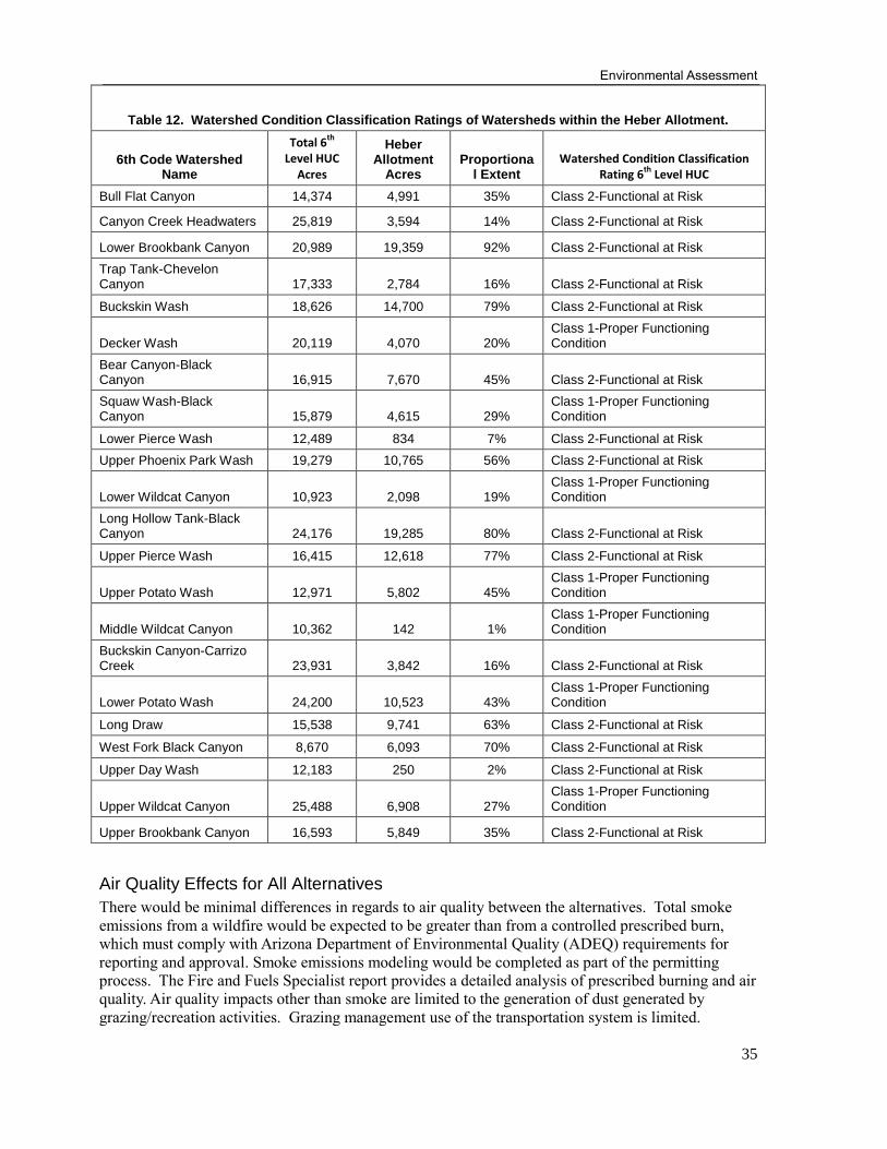
Environmental Assessment
35
Table 12. Watershed Condition Classification Ratings of Watersheds within the Heber Allotment.
6th Code Watershed Name
Total 6th
Level HUC
Acres
Heber Allotment
Acres Proportiona
l Extent
Watershed Condition Classification Rating 6
th Level HUC
Bull Flat Canyon 14,374 4,991 35% Class 2-Functional at Risk
Canyon Creek Headwaters 25,819 3,594 14% Class 2-Functional at Risk
Lower Brookbank Canyon 20,989 19,359 92% Class 2-Functional at Risk
Trap Tank-Chevelon Canyon 17,333 2,784 16% Class 2-Functional at Risk
Buckskin Wash 18,626 14,700 79% Class 2-Functional at Risk
Decker Wash 20,119 4,070 20% Class 1-Proper Functioning Condition
Bear Canyon-Black Canyon 16,915 7,670 45% Class 2-Functional at Risk
Squaw Wash-Black Canyon 15,879 4,615 29%
Class 1-Proper Functioning Condition
Lower Pierce Wash 12,489 834 7% Class 2-Functional at Risk
Upper Phoenix Park Wash 19,279 10,765 56% Class 2-Functional at Risk
Lower Wildcat Canyon 10,923 2,098 19% Class 1-Proper Functioning Condition
Long Hollow Tank-Black Canyon 24,176 19,285 80% Class 2-Functional at Risk
Upper Pierce Wash 16,415 12,618 77% Class 2-Functional at Risk
Upper Potato Wash 12,971 5,802 45% Class 1-Proper Functioning Condition
Middle Wildcat Canyon 10,362 142 1% Class 1-Proper Functioning Condition
Buckskin Canyon-Carrizo Creek 23,931 3,842 16% Class 2-Functional at Risk
Lower Potato Wash 24,200 10,523 43% Class 1-Proper Functioning Condition
Long Draw 15,538 9,741 63% Class 2-Functional at Risk
West Fork Black Canyon 8,670 6,093 70% Class 2-Functional at Risk
Upper Day Wash 12,183 250 2% Class 2-Functional at Risk
Upper Wildcat Canyon 25,488 6,908 27% Class 1-Proper Functioning Condition
Upper Brookbank Canyon 16,593 5,849 35% Class 2-Functional at Risk
Air Quality Effects for All Alternatives
There would be minimal differences in regards to air quality between the alternatives. Total smoke
emissions from a wildfire would be expected to be greater than from a controlled prescribed burn,
which must comply with Arizona Department of Environmental Quality (ADEQ) requirements for
reporting and approval. Smoke emissions modeling would be completed as part of the permitting
process. The Fire and Fuels Specialist report provides a detailed analysis of prescribed burning and air
quality. Air quality impacts other than smoke are limited to the generation of dust generated by
grazing/recreation activities. Grazing management use of the transportation system is limited.
Heber Allotment
36
Fugitive dust may be generated in areas with the highest livestock concentration or from vehicles
accessing allotments to conduct livestock management. These impacts are expected to stay within the
analysis area as dust from the very few roads settles out relatively quickly. There is no measurable
difference expected between alternatives as related to dust generated from livestock grazing activities.
BMPs should be effective in retaining protective ground cover, reducing exposed soil susceptible to
wind erosion and creation of dust in all action alternatives. The allotment is not within a State
designated non-attainment area, therefore no conformity assessment was necessary or completed.
Environmental Consequences
Alternative 1
Soil Condition and Trends
The existing condition of soils rated as satisfactory in grassland vegetation types being maintained at 0
– 10 percent canopy cover, pinyon-juniper savanna types at 10 – 20 canopy cover, and pinyon-juniper
persistent woodlands at 20 – 30 percent canopy cover would continue under the no action alternative
and trends would remain stable. Organic soil carbon would accumulate at potential rates and soil
fertility would slowly improve commensurate with the accumulation of organic matter at its existing
response rate to previous pinyon-juniper thinning and grassland restoration treatments within the
allotment. Where residual coarse woody debris has been left from previous treatments and natural
recovery of vegetative ground cover is intact and well developed, soils would be adequately protected
and stable and infiltration rates would be near potential as surface runoff is minimized.
Grassland, savanna, and persistent woodland vegetation types with impaired soil conditions due to
juniper encroachment would remain on a stable trend or have the potential for a downward trend
overtime if treatment is not implemented or maintained and current site conditions continue to persist.
Brockway et al (2001) determined that competition for limited site resources (nutrient stock, water,
sunlight, etc.) from a relatively dense juniper overstory was a principal cause for decline in understory
productivity and deterioration of soil condition at their study site on the Mountainair Ranger District
of the Cibola National Forest in New Mexico. As woody species encroachment occurs, grass biomass
and cover decrease as woody species biomass and cover increase. Additionally, herbaceous species
richness and diversity tends to decline as woody species density increases (Van Auken 2009). If these
site conditions persist, infiltration rates would gradually decrease as sheet erosion exacerbates
compaction and a reduction in organic matter accumulation in the topsoil occurs. Bare soil exposure
and connectivity would increase erosion rates and loss of vegetative ground cover could have long-
term negative impacts on site stability and productivity.
Satisfactory soils would remain in their existing state and retain a stable trend. Impaired soils have the
potential for an upward trend overtime in the absence of livestock grazing. Without the ground
disturbing impacts (compaction, soil displacement) from trampling and growth stress applied to
herbaceous vegetation during utilization, vegetation would be allowed to recover more quickly. As re-
establishment of vegetative ground cover occurs in the absence of usage/disturbance from cattle,
desirable soil productivity and stability would return at a quicker rate overtime compared to the
proposed action.
Soils across the allotment would remain in their existing condition and trend. Increased sedimentation
into stock tanks or troughs is possible if they are not maintained or improved, but the spatial extent of
these effects is very minimal across the entire allotment. Any potential effects from sedimentation in a
trough or tank would not have an influence on the overall soil condition and trend of a particular soil
unit.
Soils in locations of heavy fuel loading under a dense pinyon-juniper canopy are generally impaired

Environmental Assessment
37
and have the potential for a downward trend under alternative 1. Encroached, woodland vegetation
types across the allotment with heavy fuel loading on the ground are more susceptible to high soil burn
severity in the event of a wildfire. The loss of canopy cover, ground cover, and organic debris on the
soil surface, together with the possible occurrence of hydrophobic soil layers in these areas typically
associated with high burn severities, would likely lead to increases in soil erosion, loss of soil organic
matter, and reduction in soil fertility. Soils in grassland vegetation types would not be affected under
alternative 1 since fuel loading is inherently low in these areas. Soils would remain in their existing
conditions and have the same trends.
Roads would continue to negatively impact soil condition in some localized areas across the allotment
in the long term. Some locations are currently at impaired conditions due to instability and erosion
issues resulting from heavy ground disturbance via high densities of user-created roads and heavy
usage of off highway vehicles (OHVs). If the current usage remains the same in these particular areas,
a downward trend in soil condition may occur as current ground disturbance continues and soil loss
rates become increasingly exacerbated.
Water Quality
There would be no changes with compliance with the Clean Water Act. No potential direct or indirect
effects would occur from livestock. Although a water body within the project area, Black Canyon, is
listed (303d) as impaired with ammonia, grazing is not listed as a possible source. This alternative
would retain the most amounts of vegetation and litter, and reduce hoof compaction in areas that
currently receive livestock concentrations. Potential improved upland conditions associated with
removal of grazing could benefit water quality from decreased sediment product and transport, and
also potential loading from livestock waste.
There would be no potential benefit to water quality from reducing the risk of an altered sediment
regime associated of extensive soil high severity in areas with high coarse woody debris loading.
Without the construction of additional road side tanks, there would be no potential benefits to water
quality from greater dispersal of large ungulates away from streams and lakes within the project area.
Water Quantity
In the uplands, herbaceous ground cover, residual plant material, and plant vigor would increase
surface roughness. Soil compaction would start to break up and additional organic material
incorporated into the soil allowing for increased water infiltration and a reduction in surface runoff.
Overall, these conditions could promote more stable hydrologic flow regimes.
In areas where overstory densities are high, little long-term improvement in hydrologic flow regime
would be seen without mechanical treatment and/or prescribed fire. The soils in these areas have
reduced moisture storage and infiltration capacity and are frequently overwhelmed by high intensity
summer precipitation events, producing runoff events with relatively large peak flows of short duration
There would be minimal effects to water quantity with the absence of the proposed infrastructure
improvements.
Riparian Areas
Alternative 1 would allow the fastest possible recovery of riparian areas to desired conditions.
Riparian corridors would not be impacted by livestock related herbivory or hoof-related impacts.
Since no vegetation treatments or prescribed burning would occur under alternative 1, there would be
no improvement to upland watershed condition and riparian conditions. Coarse woody debris loading
remains high, thus there is greater risk of high burn severity and subsequent flooding effects, which
Heber Allotment
38
could negatively affect riparian condition.
There would be no benefit to riparian areas, such as decreased herbivory and bank disturbance, from
increased dispersal of large ungulates from installation of additional road side tanks.
Alternative 2: Proposed Action
Soil Condition and Trends
Overall, alternative 2 would improve vegetative and soil conditions greater than alternative 1.
Alternative 2 would retain satisfactory soil conditions across 81 percent of the project area. These soils
indicate that desirable soil function is being sustained and the ability of the soil to maintain resource
values and sustain outputs is high. Approximately 2 percent of the soil conditions across the allotment
are rated as inherently unstable or “unsuited”. Soils with this condition rating generally occur on very
steep slope gradients (greater than 40 percent), are extremely rocky, and very shallow to bedrock.
Typically, they are deemed unsuited for land management activities and use by livestock is incidental.
Soils receiving impaired condition ratings indicate the ability of the soil to function properly and
normally has been reduced and/or there exists an increased vulnerability to degradation. Impaired soils
make up the remaining 17 percent of the project area. Approximately 6 percent of that total occurs
within the southern portion of the allotment in forest vegetation types that exhibit impaired conditions
primarily due to effects from the Rodeo-Chediski fire. None of these areas are slated for woodland or
Great Basin grassland vegetation treatments. However, it is anticipated that soil conditions would
improve from prescribed fire activities in these areas as part of the Rodeo-Chediski prescribed burn
project. Therefore, the total effected spatial extent of land area across the allotment based on the
proposed action for this project is 92 percent. Of the remaining 11 percent impaired soils across the
project area in pinyon-juniper woodlands, Great Basin grasslands, and ephemeral drainage bottoms,
approximately 3 percent is proposed for vegetation treatments that should improve soil conditions in
the long-term. In total, 84 of the 92 percent potentially effected land area across the allotment are
currently at or have the potential to be improved to desirable soil conditions over time with the
implementation of the proposed action. The remaining 8 percent spatial extent is not considered
“potentially effected” acreage as the areas are either rated as unsuited for land management or would
receive treatment to improve impaired conditions through implementation of a separate proposed
action. If long-term monitoring yields data that indicates an apparent cause, the proper measures or
management actions would be explored to protect conditions against further degradation.
Water Quality
Alternative 2 would comply with the Clean Water Act. Although a water body within the project area,
Black Canyon Lake, is listed (303d) as impaired with ammonia, grazing is not listed as a possible
source. Recent field reviews and monitoring across the uplands indicate that current resource
conditions across the allotment are meeting or moving towards Forest Plan standards and guidelines.
There area few isolated areas receiving heavier use from livestock, resulting in less herbaceous
vegetation and soil compaction. These areas make up a minimal portion of the entire allotment. It is
not anticipated that water quality would be negatively impacted under this alternative based on
existing resource conditions.
As discussed above, Black Canyon Lake is listed (303d) as impaired with ammonia. Runoff from
forest fire is listed as a possible source. No prescribed fire is proposed in areas contributing water to
the lake, therefore there would be no effects from the prescribed fire treatments proposed in the
proposed action. Long-term water quality would benefit from treatment of upland areas currently not
meeting desired conditions because of departures in vegetation and fuel composition. Increased
vegetative ground cover and decreased heavy fuel loading would promote stability in natural flow and
sediment regimes. Although there may be isolated, short term disturbance of soils and vegetative
cover from implementation of these treatments, BMPs (Appendix A) would be used to maintain
Environmental Assessment
39
compliance with federal and state water quality laws. BMPs would also be utilized to minimize
potential effects of road maintenance necessary for the administration of the allotment and the
proposed temporary roads to be used to complete the treatments. All proposed temporary roads would
be decommissioned when they are no longer needed (Appendix A).
The construction of additional road side tanks would benefit water quality with greater dispersal of
large ungulates away from streams and lakes within the project area.
Water Quantity
This alternative does not provide relief from grazing pressure, as does alternative 1, however
watershed upland condition would be maintained with the monitoring/adaptive management plan (see
Monitoring/Adaptive Management Plan section).
Long-term watershed functioning would likely improve with the proposed mechanical treatments and
prescribed fire, bringing portions of the uplands to desired conditions. Site stability and fertility can
be maintained with improved hydrologic function in the uplands. Departures from historical ranges of
variability in vegetation and fire regimes have the potential for alteration of hydrologic regimes.
Juniper removal can create more uniform and dense groundcover across the uplands. Increased
understory production may add surface roughness to slow overland flows and to promote increased
infiltration rates to hold moisture on site for longer periods, thus reducing sheet flow and peak flows.
In addition, juniper treatments have resulted in increased spring flow, groundwater, and soil moisture
(Deboobt et al 2008).
Riparian Areas
Although the current condition of most of the riparian areas was improving, they were not at desired
conditions currently, being in a condition somewhat less than PFC. Because grazing is allowed in
riparian areas and during the growing season, it is expected that riparian recovery would be slower
than the no grazing alternative. Few of the riparian areas of concern are separately fenced off from the
rest of the pasture. Although, the proposed action would allow grazing on a deferred rotational pattern
throughout the year, the bottomlands would only get complete rest from livestock use during entire
growing season in pastures 1 to 2 out of every 13 years. As long-term drought conditions persist,
surface water resources are anticipated to decrease. Thus, areas with riparian vegetation are likely to
see more grazing stress. Monitoring of riparian species would be a critical component of the proposed
action. Research has shown that light to moderate use maintains overall plant health (Thorne et al
2005). Riparian areas have a greater chance for substantial improvement if browsing is monitored on
riparian herbaceous and woody species. The actual improvement that occurs in riparian areas during
or at the end of this plan would primarily depend on:
1. Climatic input: "Normal" precipitation patterns are assumed to produce sufficient moisture for
forage production in the watershed, as well as produce flows to sustain and improve riparian
conditions. Setbacks are common in riparian recovery and can be caused by unusually high
precipitation events with ensuing flood damage, or more commonly, unusually low precipitation,
causing droughts that limit growth potential. In both cases riparian recovery is substantially
affected and may produce results lower than potential under ideal conditions.
2. Adaptive management riparian monitoring: Riparian recovery depends on vegetative recovery as
well as maintenance of hydrological features such as stream banks and floodplains. Close
monitoring of livestock effects along with timely preventive action would be key to showing
success in riparian recovery.
The proposed mechanical treatments and prescribed burning could benefit riparian areas by moving
the upland vegetation and fire regime towards desired conditions. Watershed hydrologic and sediment
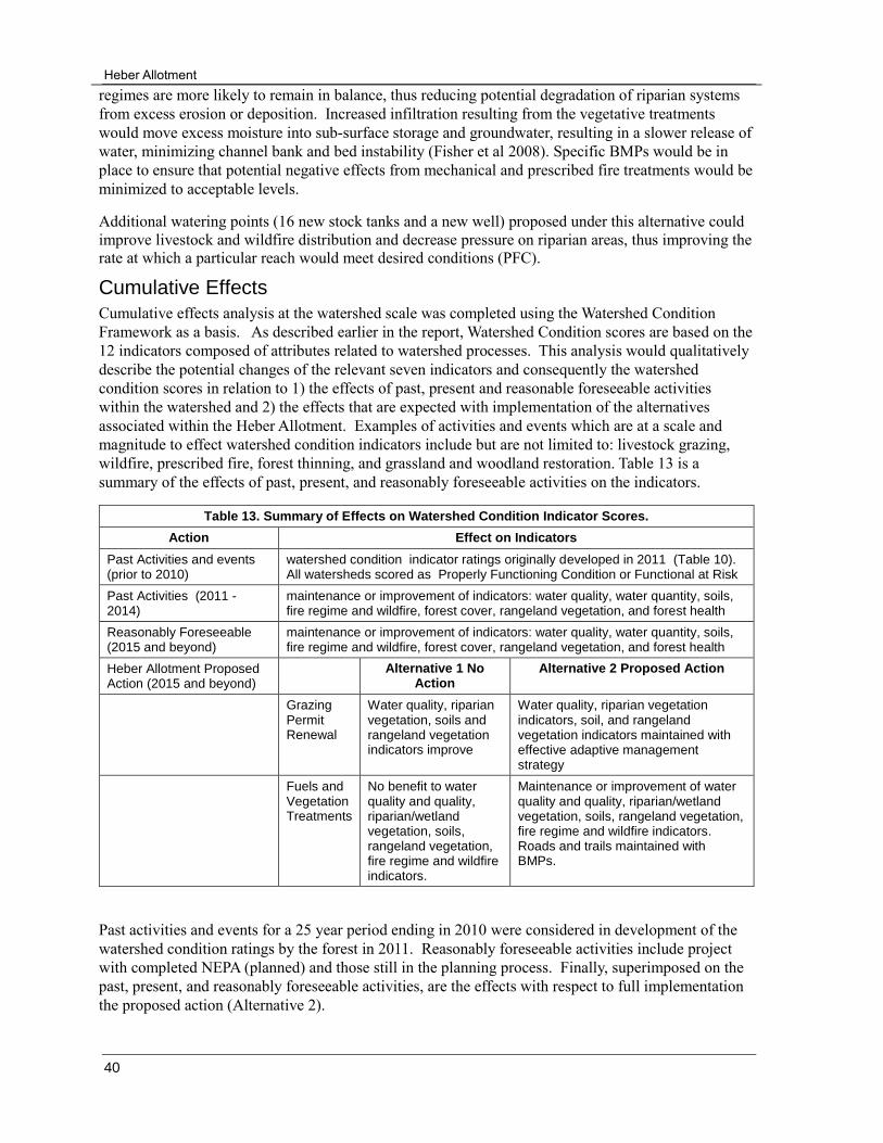
Heber Allotment
40
regimes are more likely to remain in balance, thus reducing potential degradation of riparian systems
from excess erosion or deposition. Increased infiltration resulting from the vegetative treatments
would move excess moisture into sub-surface storage and groundwater, resulting in a slower release of
water, minimizing channel bank and bed instability (Fisher et al 2008). Specific BMPs would be in
place to ensure that potential negative effects from mechanical and prescribed fire treatments would be
minimized to acceptable levels.
Additional watering points (16 new stock tanks and a new well) proposed under this alternative could
improve livestock and wildfire distribution and decrease pressure on riparian areas, thus improving the
rate at which a particular reach would meet desired conditions (PFC).
Cumulative Effects
Cumulative effects analysis at the watershed scale was completed using the Watershed Condition
Framework as a basis. As described earlier in the report, Watershed Condition scores are based on the
12 indicators composed of attributes related to watershed processes. This analysis would qualitatively
describe the potential changes of the relevant seven indicators and consequently the watershed
condition scores in relation to 1) the effects of past, present and reasonable foreseeable activities
within the watershed and 2) the effects that are expected with implementation of the alternatives
associated within the Heber Allotment. Examples of activities and events which are at a scale and
magnitude to effect watershed condition indicators include but are not limited to: livestock grazing,
wildfire, prescribed fire, forest thinning, and grassland and woodland restoration. Table 13 is a
summary of the effects of past, present, and reasonably foreseeable activities on the indicators.
Table 13. Summary of Effects on Watershed Condition Indicator Scores.
Action Effect on Indicators
Past Activities and events (prior to 2010)
watershed condition indicator ratings originally developed in 2011 (Table 10). All watersheds scored as Properly Functioning Condition or Functional at Risk
Past Activities (2011 - 2014)
maintenance or improvement of indicators: water quality, water quantity, soils, fire regime and wildfire, forest cover, rangeland vegetation, and forest health
Reasonably Foreseeable (2015 and beyond)
maintenance or improvement of indicators: water quality, water quantity, soils, fire regime and wildfire, forest cover, rangeland vegetation, and forest health
Heber Allotment Proposed Action (2015 and beyond)
Alternative 1 No Action
Alternative 2 Proposed Action
Grazing Permit Renewal
Water quality, riparian vegetation, soils and rangeland vegetation indicators improve
Water quality, riparian vegetation indicators, soil, and rangeland vegetation indicators maintained with effective adaptive management strategy
Fuels and Vegetation Treatments
No benefit to water quality and quality, riparian/wetland vegetation, soils, rangeland vegetation, fire regime and wildfire indicators.
Maintenance or improvement of water quality and quality, riparian/wetland vegetation, soils, rangeland vegetation, fire regime and wildfire indicators. Roads and trails maintained with BMPs.
Past activities and events for a 25 year period ending in 2010 were considered in development of the
watershed condition ratings by the forest in 2011. Reasonably foreseeable activities include project
with completed NEPA (planned) and those still in the planning process. Finally, superimposed on the
past, present, and reasonably foreseeable activities, are the effects with respect to full implementation
the proposed action (Alternative 2).
Environmental Assessment
41
Present and Reasonably Foreseeable Project Activities: Heber-Overgaard WUI Project
♦ Mechanical treatment of Pinyon-Juniper
Hilltop II Fuels Reduction
♦ Broadcast Burning/Pile Burning
Park Day Allotment Management Plan
♦ Pinyon-Juniper Treatment
Rodeo Chediski Fire Prescribed Burn Project
♦ Primarily Broadcast Burning
♦ Some mechanical thinning
These projects either include fuels reduction through prescribed fire or are mechanical vegetative
treatments. Coupled with similar fuels reduction and vegetative treatments included in the proposed
action for the Heber Allotment, watershed condition indicators including: soils, fire regime or wildfire,
water quantity and quantity indicators, and rangeland vegetation are expected to be maintained or
improved over the long-term. The rational on how these types of treatments benefit the various
indicator attributes was discussed in greater detail in the environmental consequences section of this
report.
The upland soils and rangeland vegetation WCF indicators would benefit from moving upland
vegetation towards desired conditions. Some short-term, localized negative effects from ground
disturbance via heavy machinery operations may occur on soils where previously completed projects
overlap proposed or future activities in watersheds across the allotment. Temporary roads constructed
in order to implement the mechanical vegetation treatments, would be opened, maintained, and closed
using forest road BMPS. Therefore, there would be no change to the roads and trails WCF indicator.
Overall, no long-term cumulative effects from ground disturbance (compaction, topsoil displacement,
etc.) from mechanical operations are anticipated to occur to a degree or spatial extent that would
negatively affect current soil condition ratings and the existing trend for any TES map unit within the
allotment with the proper implementation of soil and watershed BMPs.
Prescribed fire activities as part of this project have the potential to benefit the WCF wildfire indicator
with respect to attaining desirable vegetation structure and composition, fuel composition, and
restoring natural fire regimes in the long-term. Upland satisfactory soil condition would remain stable
and impaired soils have the potential for improvement. The proper timing and frequency of burns
planned accordingly with vegetation type characteristics (type of vegetation, climate, veg. structure,
moisture conditions, etc.), burn severity maintenance, adequate soil and watershed BMP
implementation, and the proper temporal / spatial planning of burns as not to overlap previously
burned areas still recovering are all important factors for reaching the desired condition. Recurring,
low intensity prescribed fire is a key component in the maintenance of desirable ecological and soil
condition. As long as it is maintained regularly at low to low-moderate intensities, it has the potential
to increase the rate of soil organic matter decomposition and incorporation in the long term. This helps
stimulate more vigorous herbaceous plant growth which improves site stability / productivity.
Ultimately, this should increase infiltration rates, reduce overland flow, promote stable hydrologic /
sediment regimes and ultimately improve the WCF water quality and quantity and riparian/wetland
indicators overtime.
Regarding grazing, the following allotments are active, also included is the year of the decision notice
(DN) for the last NEPA completed for the allotment: Black Canyon Allotment (DN 1998), Wildcat

Heber Allotment
42
(DN 1998), Chevelon Canyon (DN 2000), Clay Springs (DN- 1995), Willow Wash (DN 1999), Pierce
Wash (DN 1999), Park-Day (DN 1994), Long Tom (DN 2007). The management of these allotments is
expected to continue consistent with the past, therefore there are no expected changes to watershed
condition indicators. With respect to grazing permit renewal part of this proposed action, soil
condition, rangeland vegetation, water quality, and water quality indicators are expected to remain
unchanged with implementation of an effective adaptive management strategy.
Table 14 shows the proportion of watershed extent of present and reasonably foreseeable planned
activities, and those included in the Heber Allotment proposed action. Also, included are acres
associated with the Wash Fire, which occurred in 2011. Wildfire was included because as with the
vegetative and fuel reduction treatments they are at scale and magnitude to potentially contribute to
cumulative effects at the watershed scale. The proposed action treatment acres (including both
mechanical treatment and prescribed fire) is proportionally large in a few watersheds, for instance
Long Draw, Lower Brookbank, and Lower Potato, with 44, 33 and 25%, respectively. However, it is
expected that no more than around 3,000 acres of mechanical treatment would occur within the entire
allotment boundary in any given year. Three thousand acres is on average 18 % (varying between 12-
35%) of total watershed area. Prescribed burning on mechanically treated areas would not occur for a
few years after completion of the mechanical treatments when sufficient herbaceous cover is present to
carry a fire. If all the Heber Allotment proposed action mechanically treated acres did occur in a
single watershed for a given year, and in combination with all the other activities occurring in a
watershed (which would also be lagged temporally and spatially), the potential intensity of all the
watershed treatment activities are not expected to adversely affect watersheds in the short term. In
summary, the degree to which a particular indicator would improve would vary with the percentage of
watershed treated. Changing a watershed condition class would, in most cases, require changes within
a watershed that are substantial in their scope and include treatments from multiple resource areas.
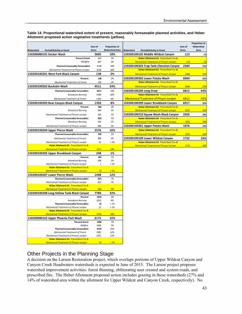
Environmental Assessment
43
Table 14. Proportional watershed extent of present, reasonably foreseeable planned activities, and Heber Allotment proposed action vegetative treatments (yellow).
Other Projects in the Planning Stage A decision on the Larson Restoration project, which overlaps portions of Upper Wildcat Canyon and
Canyon Creek Headwaters watersheds is expected in June of 2015. The Larson project proposes
watershed improvement activities: forest thinning, obliterating user created and system roads, and
prescribed fire. The Heber Allotment proposed action includes grazing in these watersheds (27% and
14% of watershed area within the allotment for Upper Wildcat and Canyon Creek, respectively). No
Watershed Period/Activity or Event
Sum of
Acres
Proportion of
Watershed Area Watershed Period/Activity or Event
Sum of
Acres
Proportion of
Watershed
Area
150200080101 Decker Wash 3605 18% 150200100105 Middle Wildcat Canyon 113 1%
Present Event 467 2% Heber Allotment EA Prescribed Fire &
Wildfire 467 2% Mechanical Treatment of Pinyon Juniper 113 1%
Planned (reasonably forseeable) 3138 16% 150200100303 Trap Tank-Chevelon Canyon 2584 15%
Mechanical Treatment of Pinyon Juniper 3138 16% Heber Allotment EA Prescribed Fire &
150200100201 West Fork Black Canyon 138 2% Mechanical Treatment of Pinyon Juniper 2584 15%
Present 138 2% 150200100302 Lower Potato Wash 6044 25%
Mechanical Treatment of Forest 138 2% Heber Allotment EA Prescribed Fire &
150200100202 Buckskin Wash 4511 24% Mechanical Treatment of Pinyon Juniper 6044 25%
Planned (reasonably forseeable) 4511 24% 150200100206 Long Draw 6812 44%Broadcast Burning 3348 18% Heber Allotment EA Prescribed Fire &
Mechanical Treatment of Forest 1163 6% Mechanical Treatment of Pinyon Juniper 6812 44%
150200100203 Bear Canyon-Black Canyon 1350 8% 150200100209 Lower Brookbank Canyon 6917 33%
Present 526 3% Heber Allotment EA Prescribed Fire &
Broadcast Burning 360 2% Mechanical Treatment of Pinyon Juniper 6917 33%
Mechanical Treatment of Pinyon Juniper 166 1% 150200100210 Squaw Wash-Black Canyon 2926 18%
Planned (reasonably forseeable) 823 5% Heber Allotment EA Prescribed Fire &
Broadcast Burning 334 2% Mechanical Treatment of Pinyon Juniper 2926 18%
Mechanical Treatment of Pinyon Juniper 489 3% 150200100301 Upper Potato Wash 1876 14%
150200100204 Upper Pierce Wash 2576 16% Heber Allotment EA Prescribed Fire &
Planned (reasonably forseeable) 359 2% Mechanical Treatment of Pinyon Juniper 1876 14%
Mechanical Treatment of Forest 309 2% 150200100109 Lower Wildcat Canyon 1722 16%Mechanical Treatment of Pinyon Juniper 51 < 1% Heber Allotment EA Prescribed Fire &
Heber Allotment EA Prescribed Fire & Mechanical Treatment of Pinyon Juniper 1722 16%
Mechanical Treatment of Pinyon Juniper 2217 14%
150200100205 Upper Brookbank Canyon 248 1%Present 169 1%
Broadcast Burning 168 1%
Mechanical Treatment of Pinyon Juniper 1 < 1%
Heber Allotment EA Prescribed Fire &
Mechanical Treatment of Pinyon Juniper 79 < 1%
150200100207 Lower Pierce Wash 1498 12%Planned (reasonably forseeable) 815 7%
Mechanical Treatment of Pinyon Juniper 815 7%
Heber Allotment EA Prescribed Fire &
Mechanical Treatment of Pinyon Juniper 683 5%
150200100208 Long Hollow Tank-Black Canyon 7789 32%Present 1010 4%
Broadcast Burning 1010 4%
Planned (reasonably forseeable) 13 < 1%
Mechanical Treatment of Pinyon Juniper 13 < 1%
Heber Allotment EA Prescribed Fire &
Mechanical Treatment of Pinyon Juniper 6766 28%
150200080102 Upper Phoenix Park Wash 6175 32%Present Event 1406 7%
Wildfire 1406 7%
Planned (reasonably forseeable) 4733 25%
Mechanical Treatment of Forest 2382 12%
Mechanical Treatment of Pinyon Juniper 2351 12%
Heber Allotment EA Prescribed Fire &
Mechanical Treatment of Pinyon Juniper 36 < 1%
Heber Allotment
44
mechanical treatments or prescribed fire acres are proposed in these watersheds. A Record of Decision
was signed January 2015 for a revision to the regulations regarding the Mexican gray wolf (USDI
1982). This revision expanded the territory to include the Sitgreaves National Forest, which includes
the Heber Allotment. It also allows for the release of wolves on the Sitgreaves. The presence of
wolves on the Heber Allotment could impact pasture rotations, livestock, distribution, and livestock
productivity. A signed decision is expected for the Forest’s Travel Management Rule in late 2016.
The rule should also reduce the number of roads crossing drainages and riparian area and keep road
users in designated areas.
In summary, because Watershed Condition Framework indicator scores are maintained or improved
with the multitude of past, present, and reasonably foreseeable actions (including the proposed action)
watershed condition framework ratings would be maintained or improved. Therefore, no adverse
watershed cumulative effects are expected.
Wildlife
Affected Environment This section includes key effects analysis and conclusions for threatened, endangered and
proposed species and critical habitat listed under the Endangered Species Act of 1973, as
amended, and Region 3 Sensitive Species, Management Indicator Species, and Migratory Birds
and their habitats within the Heber Allotment, Black Mesa Ranger District. The Wildlife
Specialist report contains detailed information and background on law, regulation, policy, forest
plan requirements, metholdology, species descriptions, etc., which are not repeated here. The
Wildlife Specialist Report is located in the project record.
Each of the species that occur or have potential to occur within the project area is analyzed in detail
within their respective section. In some cases, surveys for these species have confirmed their presence
in or near the project area. In cases where a species has not been detected, the presence of suitable
habitat indicates they could be present and their presence was assumed under this analysis. The
effects to listed species are also analyzed in a separate Biological Assessment (BA) for the purpose of
section 7 consultation with the U.S. Fish and Wildlife Service.
Federally Listed Threatened, Endangered, and Proposed Species, and Potential and Designated Critical Habitat
A species list was obtained on September 17, 2014 from the U.S. Fish and Wildlife Service (FWS)
Arizona Ecological Services, Information, Planning, and Conservation System (iPAC) [Version 1.4]
website. Concurrence on presence of species and critical habitat within the analysis area was obtained
by various FWS species specialists. For the purpose of including these species for effects analysis,
species that are known or have potential to occur within the Heber Allotment are further analyzed,
and species that are not present or do not have potential habitat in the allotment are dismissed from
further analysis as the project would have no affect to these species (Table 15).

Environmental Assessment
45
Table 15. Federally listed species on the ASNFs potentially occurring within the Heber
Allotment Analysis Area and those excluded from further analysis
Species Analyzed in Detail
Common
Name Scientific Name
Known
to
Occur?
Potential
to
Occur?
Federal
Status Critical Habitat
Mexican Gray
Wolf
Canis lupus
baileyi Yes Yes
Experimental
Population, non-
essential
No
Mexican
Spotted Owl
Strix
occidentalis
lucida
Yes Yes Threatened Yes
Narrow-
headed
Gartersnake
Thamnophis
rufipunctatus No No Threatened Yes (proposed)
Species Not Analyzed in Detail
Common
Name Scientific Name
Known
to
Occur?
Potential
to
Occur?
Federal
Status Rationale
Black-Footed
Ferret Mustela nigripes No No
Experimental
Population,
non-essential
Two experimental, non-essential
population reintroduction sites
occur in Arizona: Aubrey Valley
(236 mi to the NW of Heber
Allotment) and Espee Ranch
(100 mi to the NW of Heber
Allotment). No wild populations
have been found despite
intensive searches throughout
the ferret’s historic range. It is
very unlikely any wild
populations remain.
Southwestern
Willow
Flycatcher
Empidonax
traillii extimus No No Endangered
The project area contains
minimal cottonwood and willow
vegetation communities along
creeks and streams; previous
surveys in target areas on
district had no detections. No
Critical Habitat occurs within
the Heber Allotment.
Yellow-billed
Cuckoo
Coccyzus
americanus
occidentalis
No No Threatened
The project area contains
minimal cottonwood and willow
vegetation communities along
creeks and streams; previous
surveys in target areas on
district had no detections.
Chiricahua
Leopard Frog
Lithobates
chiricahuensis Yes No Threatened
Though several intermittent and
ephemeral drainages in the
project area as well as several
perennial stock tanks may
represent potentially suitable

Heber Allotment
46
habitat for the species, declines
in population levels since the
1980s have eliminated many
nearby populations. This species
has likely been extirpated from
the Little Colorado River
watershed. No recent (past ten
years) or historic records for the
species occur in the project
vicinity. The nearest extant
population occurs in the upper
Cherry creek drainage
approximately three miles south
of the Allotment. Due to
extreme topography, dispersal
would require greater than 1
mile overland movements. This
is further than the preferred
dispersal distances identified in
the Recovery Plan.
Northern
Mexican
Gartersnake
Thamnophis
eques megalops No No
Threatened
with
Proposed
Critical
Habitat
No THEQME have been
documented as occurring on the
Black Mesa Ranger District.
The nearest viable population
occurs in Tonto Creek near
Gisela, AZ approximately 32
miles from the project area. No
proposed Critical Habitat occurs
within or near the Heber
Allotment.
Little
Colorado
Spinedace
Lepidomeda
vittata No Yes Threatened
The LCS occurs at two
reintroduction sites on the Black
Mesa Ranger District. The West
Chevelon and Willow Creek
sites are about 11 and 16 miles
(respectively) west of the project
area. West Chevelon Creek
enters Chevelon Creek below
Chevelon Lake dam. Willow
Creek flows north and enters
Clear Creek at the ASNFs-
Coconino NF boundary. From
the project area all water flows
north into Chevelon Creek.
Critical habitat occurs in the
lower Chevelon Creek drainage,
about 35 miles north of the
project area. The distance
downstream yields a no effect
determination for the LCS.
Forest Service Sensitive Species Sensitive species are defined as “those plant and animal species identified by a Regional Forester for
which population viability is a concern, as evidenced by: (a) significant current or predicted
downward trends in population numbers or density, or (b) significant current or predicted downward
trends in habitat capability that would reduce a species’ existing distribution (FSM 2670.5(19)).” It is

Environmental Assessment
47
the policy of the Forest Service regarding sensitive species to: (1) assist states in achieving their goals
for conservation of endemic species; (2) as part of the National Environmental Policy Act process,
review programs and activities, through a biological evaluation, to determine their potential effect on
sensitive species; (3) avoid or minimize impacts to species whose viability has been identified as a
concern; (4) if impacts cannot be avoided, analyze the significance of potential adverse effects on the
population or its habitat within the area of concern and on the species as a whole (the line officer,
with project approval authority, makes the decision to allow or disallow impacts, but the decision
must not result in loss of species viability or create significant trends toward Federal listing); and (5)
establish management objectives in cooperation with the state when projects on National Forest
System lands may have a significant effect on sensitive species population numbers or distributions.
Establish objectives for Federal candidate species, in cooperation with the U.S. Fish and Wildlife
Service and state of Arizona (FSM 2670.32).
The Black Mesa Ranger District utilized the Region 3 Regional Forester’s Sensitive Species List from
2013 to assist with development of species that may occur or have suitable habitat within the project
area for effects analysis or are not analyzed in detail based upon species occurrence or habitat in the
project area (Table 16).
Table 16. Sensitive species analyzed or dismissed from further review for Effects Analysis in the
project area
SPECIES
SPECIES
STATUS
ON
DISTRICT
*
SPECIES STATUS IN ACTION AREA
Mammals
Corynorhinus townsendii
pallescens
Pale Townsend’s Big-eared Bat
U Species not known to occur; habitat present in
AMP area
Euderma maculatum
Spotted Bat
U Species not known to occur; habitat present in
AMP area
Idionycteris phyllotis
Allen’s lappet-browed bat
B Species not known to occur; habitat present in
AMP area
Cynomys gunnisoni
Gunnison’s Prairie dog
H Species may occur; habitat present in AMP area
Microtus mogollonensis navaho
Navajo Mogollon Vole
U Species may occur; habitat present in AMP area
Perognathus flavus goodpasteri
Springerville Silky Pocket
Mouse
U Species may occur; habitat present in AMP area
Birds
Accipiter gentilis
Northern Goshawk
B Species and habitat present in AMP area
Falco peregrinus anatum
American Peregrine Falcon
B Species and habitat present in AMP area
Buteogallus anthracinus
Common Black Hawk
B Species and habitat present in AMP area
Haliaeetus leucocephalus
Bald Eagle
B Species and habitat present in AMP area
Amphibians
Lithobates pipiens
Northern Leopard Frog
H Species may occur; habitat present in AMP area
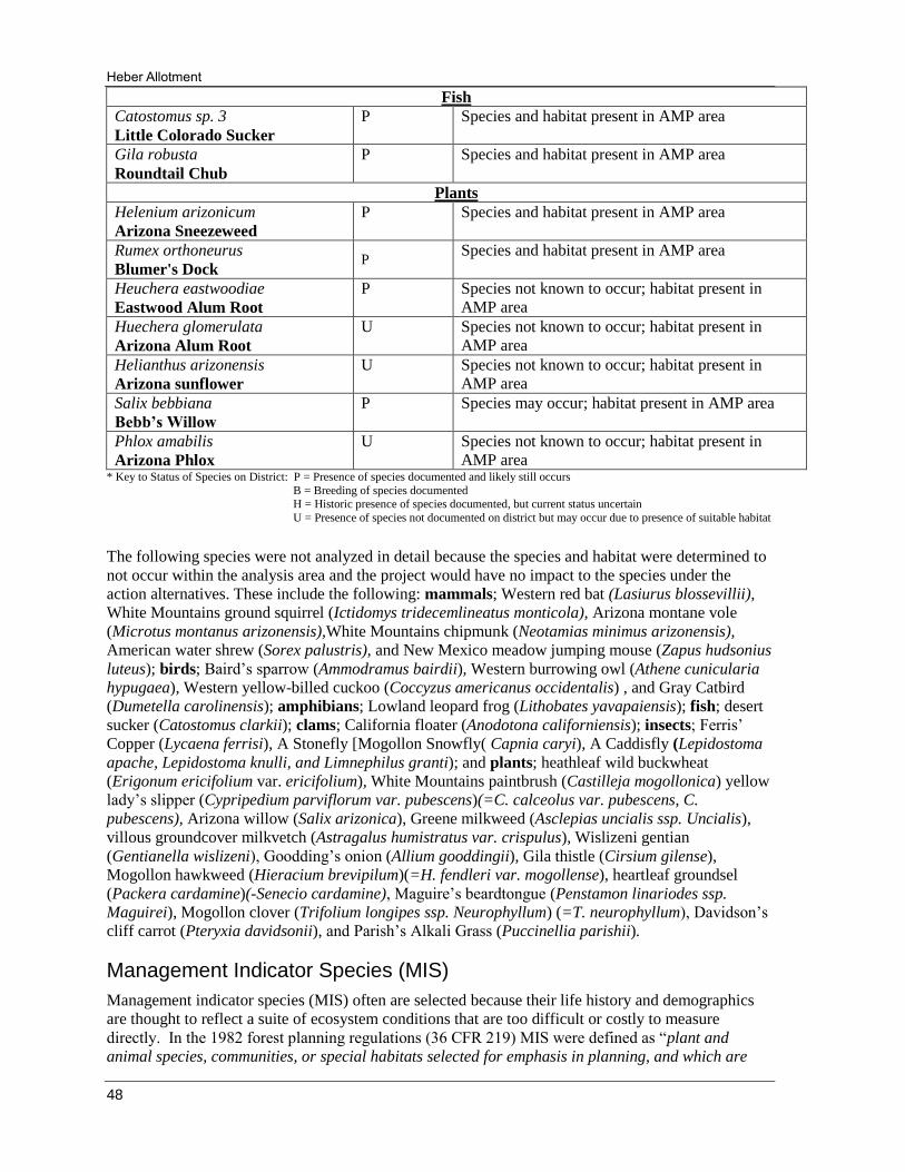
Heber Allotment
48
Fish
Catostomus sp. 3
Little Colorado Sucker
P Species and habitat present in AMP area
Gila robusta
Roundtail Chub
P Species and habitat present in AMP area
Plants
Helenium arizonicum
Arizona Sneezeweed
P Species and habitat present in AMP area
Rumex orthoneurus
Blumer's Dock P
Species and habitat present in AMP area
Heuchera eastwoodiae
Eastwood Alum Root
P Species not known to occur; habitat present in
AMP area
Huechera glomerulata
Arizona Alum Root
U Species not known to occur; habitat present in
AMP area
Helianthus arizonensis
Arizona sunflower
U Species not known to occur; habitat present in
AMP area
Salix bebbiana
Bebb’s Willow
P Species may occur; habitat present in AMP area
Phlox amabilis
Arizona Phlox
U Species not known to occur; habitat present in
AMP area * Key to Status of Species on District: P = Presence of species documented and likely still occurs
B = Breeding of species documented H = Historic presence of species documented, but current status uncertain
U = Presence of species not documented on district but may occur due to presence of suitable habitat
The following species were not analyzed in detail because the species and habitat were determined to
not occur within the analysis area and the project would have no impact to the species under the
action alternatives. These include the following: mammals; Western red bat (Lasiurus blossevillii),
White Mountains ground squirrel (Ictidomys tridecemlineatus monticola), Arizona montane vole
(Microtus montanus arizonensis),White Mountains chipmunk (Neotamias minimus arizonensis),
American water shrew (Sorex palustris), and New Mexico meadow jumping mouse (Zapus hudsonius
luteus); birds; Baird’s sparrow (Ammodramus bairdii), Western burrowing owl (Athene cunicularia
hypugaea), Western yellow-billed cuckoo (Coccyzus americanus occidentalis) , and Gray Catbird
(Dumetella carolinensis); amphibians; Lowland leopard frog (Lithobates yavapaiensis); fish; desert
sucker (Catostomus clarkii); clams; California floater (Anodotona californiensis); insects; Ferris’
Copper (Lycaena ferrisi), A Stonefly [Mogollon Snowfly( Capnia caryi), A Caddisfly (Lepidostoma
apache, Lepidostoma knulli, and Limnephilus granti); and plants; heathleaf wild buckwheat
(Erigonum ericifolium var. ericifolium), White Mountains paintbrush (Castilleja mogollonica) yellow
lady’s slipper (Cypripedium parviflorum var. pubescens)(=C. calceolus var. pubescens, C.
pubescens), Arizona willow (Salix arizonica), Greene milkweed (Asclepias uncialis ssp. Uncialis),
villous groundcover milkvetch (Astragalus humistratus var. crispulus), Wislizeni gentian
(Gentianella wislizeni), Goodding’s onion (Allium gooddingii), Gila thistle (Cirsium gilense),
Mogollon hawkweed (Hieracium brevipilum)(=H. fendleri var. mogollense), heartleaf groundsel
(Packera cardamine)(-Senecio cardamine), Maguire’s beardtongue (Penstamon linariodes ssp.
Maguirei), Mogollon clover (Trifolium longipes ssp. Neurophyllum) (=T. neurophyllum), Davidson’s
cliff carrot (Pteryxia davidsonii), and Parish’s Alkali Grass (Puccinellia parishii).
Management Indicator Species (MIS)
Management indicator species (MIS) often are selected because their life history and demographics
are thought to reflect a suite of ecosystem conditions that are too difficult or costly to measure
directly. In the 1982 forest planning regulations (36 CFR 219) MIS were defined as “plant and
animal species, communities, or special habitats selected for emphasis in planning, and which are

Environmental Assessment
49
monitored during forest plan implementation in order to assess the effects of management activities
on their populations and the populations of other species with similar habitat needs which they may
represent” (FSM 2620.5). Important characteristics of MIS are that they are capable of being
effectively monitored, and that relationships between species, habitats and response to the effects of
management activities of interest are well understood. MIS and their habitats have been used as part
of a strategy to monitor implementation of the Forest Plan and the effects to wildlife and plants.
The role of MIS and the criteria to select MIS are described in 36 CFR 219.19 (a)(1) (1982 Rule) as
follows: “In order to estimate the effects of each [Forest Plan] alternative on fish and wildlife
populations, certain vertebrate and/or invertebrate species present in the area shall be identified and
selected as management indicator species and the reasons for their selection will be stated. These
species shall be selected because their population changes are believed to indicate the effects of
management activities. In the selection of management indicator species, the following categories
shall be represented where appropriate: Endangered and threatened plant and animal species
identified on State and Federal lists for the planning area; species with special habitat needs that
may be influenced significantly by planned management programs; species commonly hunted, fished
or trapped; non-game species of special interest; and additional plant or animal species selected
because their population changes are believed to indicate the effects of management activities on
other species of selected major biological communities or on water quality.”
In 1987 the Apache-Sitgreaves National Forests Plan designated specific MIS and their associated
habitats to gauge the effects of management activities. The ASNFs LRMP lists sixteen wildlife
species and one wildlife category (aquatic macro-invertebrates) as MIS for the Forests (Table 17).
Table 17. Management Indicator Species (MIS) for the Apache-Sitgreaves NFs (1987), the
habitat component they’re selected to represent, and forest-wide habitat and population trends.
Forested and non-forested management areas are present on the allotment, although planned
vegetative treatments would only occur within pinon-juniper woodlands (MA-2) and grasslands (MA-
4). The effects of authorizing livestock grazing under the proposed action is not expected to affect
the population viability of any of the management indicator species listed above due to conservative
grazing utilization levels and associated BMPs. Based on proposed vegetative treatments in
MIS Species by Forest
Management Area
Habitat Component
Indicated
Forest-wide Habitat
Trend
Forest-wide
Population Trend
Hairy Woodpecker
Snags (all types) Upward Stable
Red-naped sapsucker Snags (Aspen) Stable Stable
Northern Goshawk Late Succession (PP) Stable to Declining Declining
Merriam’s Turkey Late Succession Stable Stable
Pygmy Nuthatch Late Succession (PP) Declining Stable
Mexican Spotted Owl Late Succession Declining Declining
Rocky Mountain Elk Early Succession Increasing Stable to Declining
Mule Deer Early Succession Increasing Stable to Increasing
Pronghorn Antelope Early succession Stable to Increasing Stable
Abert’s Squirrel Early Succession
(ponderosa pine) Stable to Declining Stable
Red Squirrel Late Succession
(spruce/mixed conifer) Declining Stable to Declining
Lincoln’s sparrow High elevation riparian Stable Stable
Juniper (Plain) Titmouse Snags Stable to Increasing Stable
Lucy’s warbler Low-elevation riparian Stable Stable
Yellow-breasted chat Low elevation Stable Stable
Cinnamon teal Wetlands Stable to Declining Stable
Aquatic Macroinvertebrates Riparian Habitats Declining Declining

Heber Allotment
50
woodland and grassland areas within the allotment, the MIS listed in Table 18 would be evaluated
further.
Table 18. MIS within the Heber Allotment project area, with forest-wide habitat and
population trend and project area acres present.
Migratory Birds
Executive Order 13186 (2001) and a 2008 memorandum of understanding between the USDA Forest
Service and USDI Fish and Wildlife Service provide direction to conserve migratory birds, restore or
enhance habitat, and consider them in the planning process. This order requires that an analysis be
made of the effects of Forest Service actions on species of concern and important bird areas (IBAs) as
listed and identified by Partners in Flight (Latta et al 1999), and the effects to important overwintering
areas.
Considered for these analyses were (1) birds identified as priority species in the Arizona Partners in
Flight Bird Conservation Plan (Latta et al 1999) (APIF Plan) and (2) birds in Bird Conservation
Regions 34 and 16 of U.S. Fish and Wildlife Service’s 2008 Birds of Conservation Concern (BCC)
(USDI 2008). Important Bird Areas (IBAs) are also addressed.
Based on the APIF Plan and BCC, a total of 41 species have been identified as species of concern in
ASNFs habitats. Five of these, including Mexican spotted owl, northern goshawk, bald eagle,
peregrine falcon, and common blackhawk are discussed in the Threatened, Endangered, and Sensitive
Species Biological Analysis and Evaluation and will not be discussed further here. Swainson’s thrush
(spruce-fir), pine grosbeak (spruce-fir), golden-crowned kinglet (spruce-fir), Cassin’s sparrow (semi-
desert grassland), Bendire’s thrasher (semi-desert grassland), black-chinned sparrow (interior
chaparral), Virginia’s warbler (interior chaparral), Lucy’s warbler (low elevation riparian), veery (low
elevation riparian), elf owl (low elevation riparian), Western yellow-billed cuckoo (low elevation
riparian), Bell’s vireo (low elevation riparian) and yellow warbler (low elevation riparian) were not
discussed in this analysis because no habitat for these species occurs within the project area.
MIS Species by
Forest
Management Area
Habitat
Component
Indicated
Forest-wide
Habitat
Trend
Forest-wide
Population Trend
Acres of
Habitat
Forest-wide
Acres to be
analyzed
in Project
Area
Mule Deer Early
Succession Increasing
Stable to
Increasing 1,769,299 53,725
Rocky Mountain Elk Early
Succession Increasing Stable to Declining 1,690,439 73,913
Juniper titmouse
Late seral
and snag
component
of piñon-
juniper
woodland
Upward Stable to
Increasing 784,532 51,406
Pronghorn antelope
Early
successional
woodlands
Stable to
Increasing Stable 854,151 71,594
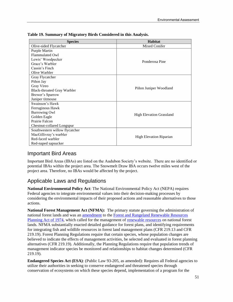
Environmental Assessment
51
Table 19. Summary of Migratory Birds Considered in this Analysis.
Species Habitat
Olive-sided Flycatcher Mixed Conifer
Purple Martin
Flammulated Owl
Lewis’ Woodpecker
Grace’s Warbler
Cassin’s Finch
Olive Warbler
Ponderosa Pine
Gray Flycatcher
Piñon Jay
Gray Vireo
Black-throated Gray Warbler
Brewer’s Sparrow
Juniper titmouse
Piñon Juniper Woodland
Swainson’s Hawk
Ferruginous Hawk
Burrowing Owl
Golden Eagle
Prairie Falcon
Chestnut-collared Longspur
High Elevation Grassland
Southwestern willow flycatcher
MacGillivray’s warbler
Red-faced warbler
Red-naped sapsucker
High Elevation Riparian
Important Bird Areas
Important Bird Areas (IBAs) are listed on the Audubon Society’s website. There are no identified or
potential IBAs within the project area. The Snowmelt Draw IBA occurs twelve miles west of the
project area. Therefore, no IBAs would be affected by the project.
Applicable Laws and Regulations
National Environmental Policy Act: The National Environmental Policy Act (NEPA) requires
Federal agencies to integrate environmental values into their decision-making processes by
considering the environmental impacts of their proposed actions and reasonable alternatives to those
actions.
National Forest Management Act (NFMA): The primary statute governing the administration of
national forest lands and was an amendment to the Forest and Rangeland Renewable Resources
Planning Act of 1974, which called for the management of renewable resources on national forest
lands. NFMA substantially enacted detailed guidance for forest plans, and identifying requirements
for integrating fish and wildlife resources in forest land management plans (CFR 219.13 and CFR
219.19). Forest Planning Regulations require that certain species, whose population changes are
believed to indicate the effects of management activities, be selected and evaluated in forest planning
alternatives (CFR 219.19). Additionally, the Planning Regulations require that population trends of
management indicator species be monitored and relationships to habitat changes determined (CFR
219.19).
Endangered Species Act (ESA): (Public Law 93-205, as amended): Requires all Federal agencies to
utilize their authorities in seeking to conserve endangered and threatened species through
conservation of ecosystems on which these species depend, implementation of a program for the

Heber Allotment
52
conservation of these species, and taking appropriate steps to achieving the purposes of treaties and
conventions set forth in the Act.
Bald and Golden Eagle Protection Act (Eagle Act): The Eagle Act, originally passed in 1940,
prohibits the take, possession, sale, purchase, barter, offer to sell, purchase, or barter, transport,
export, or import, of any bald or golden eagle, alive or dead, including any part, nest, or egg, unless
allowed by permit (16U.S.C 668(a);50CFR 22). “Take” is defined as “pursue, shoot, shoot at, poison,
wound, kill, capture, trap, collect, molest, or disturb” a bald or golden eagle. The term “disturb” under
the Eagle Act was recently defined via a final rule published in the Federal Register on June 5, 2007
(72 FR 31332). “Disturb” means to agitate or bother a bald or golden eagle to a degree that causes, or
is likely to cause, based on the best scientific information available, 1) injury to an eagle, 2) a
decrease in its productivity, by substantially interfering with normal breeding, feeding, or sheltering
behavior, or 3) nest abandonment, by substantially interfering with normal breeding, feeding, or
sheltering behavior.
E.O. 31186 Responsibilities for Federal Agencies to Protect Migratory Birds: President Clinton
signed Executive Order 13186 on January 10, 2001, placing emphasis on conservation of migratory
birds. This order requires that an analysis be made of the effects of Forest Service actions on species
of concern and important bird areas (IBAs) as listed and identified by Partners in Flight (Latta et al
1999), and the effects to important overwintering areas.
E.O. 13443 Facilitation of Hunting Heritage and Wildlife Conservation: The purpose of this
order is to direct Federal agencies that have programs and activities that have a measurable effect on
public land management, outdoor recreation, and wildlife management, including the Department of
the Interior and the Department of Agriculture, to facilitate the expansion and enhancement of
hunting opportunities and the management of game species and their habitat.
Effects of Alternatives on Wildlife Resources
Threatened, Endangered, and proposed species, and designated and proposed critical habitat (Listed),
Region 3 Sensitive Species, ASNFs Management Indicator Species, and Migratory Birds and their
habitats are analyzed for effects and determinations of the No Action (alternative 1) and Proposed
Action (alternative 2) considering existing conditions, life history and affected habitats, and
cumulative effects.
Alternative 1 - No Action
Federally Listed and Forest Service Sensitive species Direct and Indirect Effects Not authorizing livestock on the allotment would reduce utilization of herbaceous and browse plant species and provide more forage and cover for wildlife. The opportunity for recruitment of individuals into populations would be higher with the implementation of this alternative compared to the proposed action alternative. The implementation of this alternative would provide the greatest opportunity for habitat improvement for many plant and wildlife species. Consumption, trampling, and compactions normally associated with larger animals (cattle) would not occur under this alternative, which could result in improved soil stability and less stream turbidity. Since there would be no livestock grazing of the forage resources on the allotment, disturbance related to the herding and management of livestock such as their associated herders, 4-wheelers, and horses would not occur.
Proposed vegetation treatments would not occur, and stands of piñon-juniper woodlands would remain dense and overstocked, with continued degradation of the habitat, for those species dependent on woodland. Grassland maintenance would also not occur with encroachment of piñon-juniper into grasslands continuing to degrade habitat for those species dependent on grasslands.
The species not expected to benefit from this alternative are those associated with piñon-juniper and
grassland habitats. Gunnison’s prairie dog, Navajo Mogollon vole, and Springerville silky pocket

Environmental Assessment
53
mouse would benefit from thinning of overstocked piñon-juniper woodland, and these woodlands
would continue to exhibit reduced habitat quality due to high canopy cover and reduced forage
production.
The primary benefit of this alternative is that recovery of soils, watershed, and riparian conditions would occur, and would be quicker than with the action alternative. Increases in ungrazed available herbaceous and browse forage would be expected to result in higher densities of insects, small mammals, passerine birds, game animals and other wildlife species that depend on grasses, forbs, and leaders on woody shrubs and mast for food.
Cumulative Effects
Past cumulative effects for this report were bounded by the Heber Allotment Boundary and took into
account all activities within the last 25 years that may have an effect on wildlife resources (Appendix
B) under alternative 1.
Present and reasonably foreseeable activities are activities that are currently in progress or may take
place in the near future. These activities were obtained from various specialists on the ID Team and
district personnel. Only activities that are likely to affect vegetation and grazing within the Heber
Allotment are reported. Generally, these activities are likely to occur in the next 5 years.
Alternative 2 – Proposed Action
Direct and Indirect Effects
Maintaining conservative utilization standards with a deferred, rest rotation grazing system would
ensure effects to listed, proposed, sensitive, MIS, and migratory bird species are minimized.
Responses of wildlife to forest treatments vary widely based on species studied, response variable,
treatment examined, and the temporal and spatial extent of the study design (Kalies et al 2009). In
general, wildlife that utilize a mosaic of disturbed and undisturbed forest stands for reproduction,
foraging, and cover may benefit from fuel treatments while other species that are associated with
large patches of high density trees and more complex structure may lose habitat through fuel
treatments (Pilliod et al 2006).
The following are direct effects to wildlife from restoration treatments:
• Direct mortality to wildlife to crushing from heavy equipment, incineration, or asphyxiation during fuel reduction is considered low. It is believed that most species are able to find refuge or move away from approaching equipment, heat, or smoke (Pilliod et al 2006).
• Human disturbance may be in the form of noise, human presence, or anything that causes displacement, avoidance, stress or other behavioral responses. Although short-term, human presence during treatment activities, and human-created unfamiliar or proximate noise disturbance, may displace wildlife from preferred habitats, may cause animals to move faster and further than they otherwise would, and may also cause stress to wildlife. This disturbance would likely be very short-term while the activities are taking place.
• Modification to habitat features or loss of habitat could occur for some species. Important habitat components for wildlife include snags, downed logs and woody debris, old growth, oaks, and browse.
Although the immediate direct effects may have some negative impacts on wildlife, long-term effects
are expected to result in beneficial impacts. Wildlife species in the Southwest have evolved in fire
adapted ecosystems. Studies show that small-diameter removal and/or burning does not negatively
affect species’ densities compared to unmanaged forest stands, and is less detrimental than overstory
removal or wildfire; therefore, it is assumed that treatments which restore conditions consistent with
these species have adapted to over evolutionary time and would have more beneficial effects (Kalies
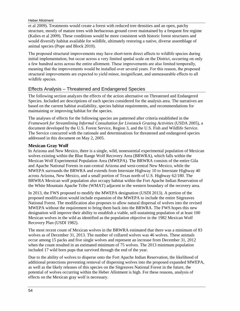
Heber Allotment
54
et al 2009). Treatments would create a forest with reduced tree densities and an open, patchy
structure, mostly of mature trees with herbaceous ground cover maintained by a frequent fire regime
(Kalies et al 2009). These conditions would be more consistent with historic forest structures and
would diversify habitat available for wildlife, ultimately restoring a native, diverse assemblage of
animal species (Pope and Block 2010).
The proposed structural improvements may have short-term direct affects to wildlife species during
initial implementation, but occur across a very limited spatial scale on the District, occurring on only
a few hundred acres across the entire allotment. These improvements are also limited temporally,
meaning that the improvements would be installed over several years. For this reason, the proposed
structural improvements are expected to yield minor, insignificant, and unmeasurable effects to all
wildlife species.
Effects Analysis – Threatened and Endangered Species
The following section analyzes the effects of the action alternative on Threatened and Endangered
Species. Included are descriptions of each species considered for the analysis area. The narratives are
based on the current habitat availability, species habitat requirements, and recommendations for
maintaining or improving habitat for the species.
The analyses of effects for the following species are patterned after criteria established in the
Framework for Streamlining Informal Consultation for Livestock Grazing Activities (USDA 2005), a
document developed by the U.S. Forest Service, Region 3, and the U.S. Fish and Wildlife Service.
The Service concurred with the rationale and determinations for threatened and endangered species
addressed in this document on May 2, 2005.
Mexican Gray Wolf In Arizona and New Mexico, there is a single, wild, nonessential experimental population of Mexican
wolves existing within the Blue Range Wolf Recovery Area (BRWRA), which falls within the
Mexican Wolf Experimental Population Area (MWEPA). The BRWRA consists of the entire Gila
and Apache National Forests in east-central Arizona and west-central New Mexico, while the
MWEPA surrounds the BRWRA and extends from Interstate Highway 10 to Interstate Highway 40
across Arizona, New Mexico, and a small portion of Texas north of U.S. Highway 62/180. The
BRWRA Mexican wolf population also occupy habitat within the Fort Apache Indian Reservation of
the White Mountain Apache Tribe (WMAT) adjacent to the western boundary of the recovery area.
In 2013, the FWS proposed to modify the MWEPA designation (USDI 2013). A portion of the
proposed modification would include expansion of the MWEPA to include the entire Sitgreaves
National Forest. The modification also proposes to allow natural dispersal of wolves into the revised
MWEPA without the requirement to bring them back into the BRWRA. The FWS hopes this new
designation will improve their ability to establish a viable, self-sustaining population of at least 100
Mexican wolves in the wild as identified as the population objective in the 1982 Mexican Wolf
Recovery Plan (USDI 1982).
The most recent count of Mexican wolves in the BRWRA estimated that there was a minimum of 83
wolves as of December 31, 2013. The number of collared wolves was 46 wolves. These animals
occur among 15 packs and five single wolves and represent an increase from December 31, 2012
when the count resulted in an estimated minimum of 75 wolves. The 2013 minimum population
included 17 wild born pups that survived through the end of the year.
Due to the ability of wolves to disperse onto the Fort Apache Indian Reservation, the likelihood of
additional protections preventing removal of dispersing wolves into the proposed expanded MWEPA,
as well as the likely releases of this species on the Sitgreaves National Forest in the future, the
potential of wolves occurring within the Heber Allotment is high. For these reasons, analysis of
effects on the Mexican gray wolf is necessary.
Environmental Assessment
55
Per the 10(j) rule, “disturbance-causing land use activity” means any land use activity that the FWS
determines could adversely affect reproductive success, natural behavior, or survival of Mexican gray
wolves. These activities may be temporarily restricted within a 1-mile radius of release pens, active
dens, and wolf rendezvous sites. Such activities, as related to livestock grazing, may include, but are
not limited to, timber or wood harvesting, management-ignited fire, […] livestock trailing and drives,
[…], and any other use or activity with the potential to disturb wolves. The following activities are
specifically excluded from this definition: 1) legally permitted livestock grazing and use of water
sources by livestock; 2) livestock trailing or drives (only if no reasonable alternative route or timing
exists); […] 5) prescribed fire and associated management actions (except in the vicinity of wolf
release pens); […].
Alternative 2 – Proposed Action
Direct and indirect effects
Livestock grazing can have potentially negative direct effects on wolves especially if wolves become
accustomed to cattle as preferred prey. This would often induce management activities aimed at
controlling or eliminating these large predators (Zwartjes et al 2005). In instances where proposed
livestock grazing and livestock management activities may adversely affect the wolf, it is strongly
recommended that USFS personal and affected livestock permittees work with the Mexican gray wolf
IFT to arrive at a solution.
Cumulative Effect: Activities identified in Appendix B add to the cumulative effects to this species
by disturbance related activities.
Determination of effect
The effect of this project on the Mexican gray wolf considers the following information:
1. The 10(j) rule establishes that certain activities associated with the proposed action for
the Heber Allotment would be considered “disturbance-causing land use activities”.
These include the proposed woodland and grassland restoration, management-ignited
fires, livestock trailing, and water developments.
2. The 10(j) rule excludes certain activities from its rule that would “disturb” any Mexican
gray wolves within the project vicinity. Activities that would be excluded as related to the
Heber Allotment include legally permitted livestock grazing and use of water sources by
livestock, livestock trailing where no reasonable alternative route or timing exists, and
prescribed fire and associated management actions.
3. Where negative interactions occur between wolves and livestock, it is strongly
recommended that USFS personal and affected livestock Permittees work with the
Mexican gray wolf IFT to arrive at a solution.
In compliance with 50 CFR 17.84(k) this species is treated as proposed endangered. Given the
continued health of captive Mexican gray wolves and the determination by the FWS that these
Mexican gray wolves are not essential “to the continued existence of the species in the wild”, the
occurrence of any “unavoidable and unintentional take” and/or the occurrence of any “opportunistic,
non-injurious harassment” of nonessential experimental Mexican gray wolves is not likely to
jeopardize the continued existence of the species.
Based on the above information it has been determined that the actions proposed for the Heber
Allotment Management Plan are not likely to jeopardize the continued existence of the Mexican gray
wolf. This is consistent with the direction given in the “guidance criteria” (March 15, 2005).
Heber Allotment
56
Mexican spotted owl
Protected Activity Centers (PAC’s) are categorized as MSO protected habitat in the Mexican Spotted
Owl Recovery Plan (USDI 2012). The Heber Allotment Analysis Area contains approximately 7,287
acres of MSO protected habitat within 12 designated PACs. Four of these PACs (consisting of 2,426
acres) are proposed for decommissioning due to a lack of MSO detections since the 2002 RC Fire.
Recovery habitat is defined as areas outside of PACs that are managed as nest/roost, foraging,
dispersal, and wintering habitats. Recovery habitat typically includes pine-oak, mixed conifer, and
riparian forests as well as rocky canyons (USDI 2012). Recovery habitat has not been generated for
this project through current stand data; however, a restricted habitat layer (1995 Recovery Plan)
identifies 2,545 acres within the Heber Allotment as Restricted habitat. This acreage figure should be
used with caution due to its creation prior to the RC Fire. Though these areas experienced low
severity burns many of them experienced other habitat changes after the fire due to stressors
associated with drought and bark beetles. These stressors further altered habitat conditions resulting
in less than optimal habitat components required for MSO nesting and roosting.
Mexican spotted owl critical habitat was designated by the FWS in 2004 (USDI 2004). Critical
habitat is defined as protected and restricted habitats which contain the primary constituent elements
(PCEs) necessary for conservation of the species within the designated critical habitat units (USDI
2004). Approximately 37,222 acres of the Heber Allotment occur within the critical habitat boundary.
Areas within designated critical habitat must be managed to maintain or enhance primary constituent
habitat elements. These elements include criteria associated with the range of tree and plant species,
canopy closure, snags, downed logs, and residual plant cover (USDI 2004).
Alternative 2 – Proposed Action
Direct and indirect effects
The USDA Forest Service provides a framework for streamlining informal consultation for livestock
grazing activities (USDA 2005). This framework uses the following criteria to support a “may affect,
not likely to adversely affect” determination on Mexican spotted owls for livestock grazing activities.
The livestock grazing activity must meet criteria 1 through 3 below:
1. In the action area, livestock grazing or livestock management activities would occur within
PACs, but no human disturbance or construction associated with the livestock grazing would
occur in PACs during the breeding season.
2. Livestock grazing and livestock management in PACs would be managed to provide the
woody and herbaceous cover for rodent prey, biomass to support broadcast burns that reduce
the risk of catastrophic wildfire, and regeneration of riparian trees.
3. Forage utilization would be maintained at conservative levels in owl foraging areas.
Regarding criteria 1: Twelve PACs occur within the Heber Allotment action area south of Highway
260. Livestock grazing and associated management activities would occur in PACs during the
breeding season; however, grazing related human disturbance or construction activities would not
occur in PACs during the breeding season.
No fences occur within any established PACs; therefore, fence maintenance would not be an
issue in the breeding season.
No cattleguard installation or vegetation treatments are proposed for any MSO protected or
recovery habitats.
Four pit tanks are proposed within three PACs; however, these PACs are designated for
decommissioning. Actions associated with the construction of these pit tanks would not occur
during the breeding season unless FWS concurs with the District’s request to decommission
these PACs in the future.

Environmental Assessment
57
Regarding criteria 2: The Heber Allotment management plan proposes to authorize conservative
grazing on the Allotment allowing for 25 to 35 percent utilization levels by the end of each grazing
season. Each pasture would receive periodic growing season rest and the ability to adjust for rest
based on pasture conditions (determined via proposed monitoring plans). Through no vegetation
treatments are proposed within PACs, this type of grazing regime is expected to provide for adequate
levels of herbaceous cover for rodent prey as well as biomass to support low severity fires and reduce
hazards associated with stand-replacing wildfire in PACs. The development of waters within and near
PACs would also decrease reliance on riparian systems and allow for higher regeneration of riparian
plant species.
Regarding criteria 3: The Heber Allotment proposed action has determined that initial AUMs of 5,430
cows/calves and a rest rotation schedule of each pasture would allow for forage utilization levels to be
maintained at conservative levels as defined in the Framework for Streamlining Informal
Consultation for Livestock Grazing Activities (USDA 2005).
Designated Critical Habitat
The primary constituent elements (PCEs) essential to the conservation of the MSO include those
physical and biological features that support nesting, roosting, and foraging. These are separated into
those that meet forest structure requirements and those that meet adequate prey species requirements.
PCEs related to forest structure are:
A range of tree species, including mixed conifer, pine-oak, and riparian forest types,
composed of different tree sizes reflecting different ages of trees, 30 percent to 45 percent
of which are large trees with a trunk diameter of 12 inches or more when measured at 4.5
feet from the ground.
A shade canopy created by the tree branches covering 40 percent or more of the ground.
Large dead trees with a trunk diameter of at least 12 inches when measured at 4.5 feet
from the ground.
PCEs related to maintenance of adequate prey species are:
High volumes of fallen trees and other woody debris.
A wide range of tree and plant species including hardwoods.
Adequate levels of residual plant cover to maintain fruits, seeds, and allow plant
regeneration.
Direct and indirect effects to forest structure
Grazing may impact PCEs related to forest structure in pine-oak woodland through altered
susceptibility to high severity crown fires (USDI 1995b). A reduction in ground cover from grazing
decreases low-intensity ground fires and encourages fuel accumulations and shrub and tree
propagation. Fire regimes of other forest types such as mixed-conifer or spruce-fir are not as impacted
through grazing; however, the risk of catastrophic fire in these forests may be increased if they are
adjacent to dog-hair thicket ponderosa pine forests (Zwartjes et al 2005).
MSO PACs only occur within the 2002 RC Fire boundary on the Heber Allotment. Since the 2002
RC Fire, ponderosa pine regeneration has been prolific. Many upland areas are experiencing heavy
growth of ponderosa pine dog-hair thickets. This growth, however, is unrelated to grazing due to the
fact that grazing was not authorized within the RC area until 2006 and 2007 and only at conservative
levels. Therefore, any current risk of wildfire to the MSO due to upland conditions is unrelated to
current grazing practices. Proposed grazing within the allotment would also be maintained at
conservative levels. This reduces the pressure on herbaceous vegetation and allows for the continued
presence of the beneficial low-intensity ground fires should natural or management fires occur within
Heber Allotment
58
the Allotment. Therefore, grazing within the Heber Allotment is not expected to alter any MSO
habitat’s susceptibility to fire.
Grazing in riparian habitat may adversely impact PCEs related to forest structure, because of
degeneration of riparian plant communities and impaired ability of plant communities to develop into
MSO habitat (USDI 1995b). Approximately 57.4 acres of Cottonwood/Willow/Riparian habitat has
been fenced within the Heber Allotment. This occurs mainly in Wildcat Canyon (five fences totaling
1.8 acres), Gentry Canyon (one fence totaling 32.8 acres), Black Canyon (one fence totaling 18.2
acres), and Phoenix Park Wash (one fence totaling 4.6 acres). Riparian habitat in the Heber Allotment
primarily occurs in drainage bottoms. Since less than 1 mile of perennial water occurs within
drainages in the Heber Allotment, riparian habitat is likely maintained by subsurface water. In
addition, there are 30 water developments (guzzlers, trick tanks) scattered across the allotment, most
placed north of Highway 260 where drier conditions exist. The Arizona Game and Fish Department is
currently replacing these structures with a high capacity design (from 2-3,000 gallon capacity to
20,000 gallon capacity) at a rate of 2 to 4 structures per year per GMU. This would aid in better
distributing livestock and wildlife across the allotment, reducing the pressure from grazers on
sensitive riparian habitat. Native vegetation has evolved with herbivores, and has adapted to be
grazed periodically. Riparian habitat has persisted under current grazing pressure. With proposed
grazing pressure in riparian habitat, structural complexity of the habitat would remain intact by
allowing recruitment of new woody vegetation (Zwartjes et al 2005). Reduced grazing pressure
through conservative forage utilization standards throughout the allotment would allow for structural
complexity to be maintained and vegetation to continue developing the PCEs in riparian habitat for
MSO prey species.
Direct and indirect effects to maintenance of adequate prey species
Grazing that takes place in upland, meadow, and riparian habitats has the potential to impact PCEs
related to maintenance of adequate prey species (USDI 1995b). Changes in plant communities or
structures not only result in changes to the small mammal composition, it also results in a decrease in
small mammal abundance, which influences the owl’s reproductive success (USDI 1995b). The
conservative forage utilization standard within the Heber Allotment is expected to provide adequate
levels of residual plant cover for MSO prey species as a result of proposed vegetation treatment
projects. This level of utilization should allow for plant regeneration and maintenance of fruits and
seeds used as forage by small mammals.
Proposed vegetation treatments may produce short-term affects to rodent prey species. Rodents may
be killed or injured during mastication or thinning activities. As habitat recovers, increased
herbaceous vegetation may provide better habitat structure and forage for rodent prey. Changes in
small mammal species composition may occur as habitats open up and support more grassland
dependent species. This, however, should not have a major effect on the amount of available prey.
These effects would be of minimal importance to the owl during the summer months since the
proposed treatments would occur in pinyon-juniper habitats that are not utilized by the owl as
foraging areas during the breeding season. However, it is not well known what habitat types support
the foraging needs of this species outside of the breeding season. It is likely that open pinyon-juniper
and grassland habitats may provide important foraging habitats for these birds during the winter.
Wet meadows within the Heber Allotment occur mainly within Gentry Canyon and Baca Meadow,
both of which have been fenced to keep cattle and other wild ungulates out and provide adequate
herbaceous cover for important MSO prey species such as voles and shrews.
Based on the analysis above, a determination of “may affect, not likely to adversely affect” was made
for MSO and its designated critical habitat. Under this determination, incidental take of Mexican
spotted owls would not occur as a result of the proposed action.

Environmental Assessment
59
Based on this, the proposed action is consistent with The Biological Assessment for the Reinitiation
of Consultation on the Forest Service’s Continued Implementation of the Land and Resource
Management Plans for the Apache-Sitgreaves NFs of the Southwestern Region U.S.D.A. Forest
Service (USDI 2012b).
Cumulative Effects: Activities identified in Appendix B were considered for the cumulative effects to
critical habitat, forest structure, and prey species by disturbance related activities.
Determination of effect
The effects of this project the Mexican spotted owl considers the following information:
1. Twelve PACs occur within the Heber Allotment. While livestock grazing and associated
management activities will occur in PACs during the breeding season, grazing related human
disturbance or construction activities will not occur in PACs during the breeding season.
2. A conservative grazing utilization level and period pasture rest/rotation schedule is proposed
for the Heber Allotment. Under this grazing structure adequate levels of herbaceous cover for
rodent prey and biomass to support low severity fires will occur.
3. Water developments would reduce pressure on riparian areas and allow for higher
regeneration of riparian plant species.
4. Proposed action management and conservation measures are in place. In the event that
conservation measures do not accomplish site specific resource objectives, additional optional
measures may be implemented. Field surveys for MSO will be conducted prior to extensive
reconstruction of existing improvements or the construction of new range improvements.
Adjustments will be made in the location of improvements or the timing of construction, as
appropriate, in order to avoid adverse effects. Consultation with the FWS will be conducted
as appropriate.
The effect of this project on Mexican spotted owl critical habitat considers the following information:
1. Proposed grazing on the Heber Allotment is not expected to alter any MSO habitat’s
susceptibility to fire due to the conservative grazing level.
2. Riparian habitat has persisted under current grazing pressure. Proposed grazing pressure in
riparian habitats should allow for maintenance of structural complexity through the
recruitment of new woody vegetation.
3. The conservative forage utilization standard and proposed vegetation treatments are expected
to provide for adequate levels of residual plant cover for MSO prey and will allow for plant
regeneration and maintenance of fruits and seeds used as forage by small mammals.
4. Wet meadows and spring seeps are fenced are fenced and excluded from all ungulate grazing
within the Heber Allotment. This will provide adequate herbaceous cover for important MSO
prey species such as voles and shrews.
Based on the above discussion, it has been determined that the actions proposed for the Heber
Allotment Management Plan may affect, but are not likely to adversely affect the Mexican spotted
owl or its designated critical habitat.
Narrow-headed Gartersnake (Thamnophis rufipunctatus)
The NHG was designated as a threatened species in 2014 (USDI 2014). There are no current or
historical records of NHGs occurring within the Little Colorado River Subbasin (Servoss 2014),
which surrounds the majority of the Black Mesa Ranger District and the Heber Allotment. The
potential for the NHG occurrence would be within the Upper Salt River Subbasin, specifically within
the Carrizo Creek drainage on White Mountain Apache Tribal lands. This is based upon observation
reports for NHG from the 1980’s as well as a photo voucher from 1997 as documented by Holycross
Heber Allotment
60
and others (2006). No NHG have been documented from the upper-most reach of Carrizo Creek on
the Black Mesa Ranger District.
Critical habitat has been proposed since July of 2013 (USDI 2013b). Proposed critical habitat occurs
within the Heber Allotment along the Carrizo Creek drainage (1.1 miles on the allotment). The
Carrizo Creek drainage on the ASNFs is not perennial but does contain small ephemeral pools of
natural water mainly during periods of snow melt but also occasionally during the monsoon season.
These pools are short in duration and do not provide for the habitat components necessary, such as
riparian vegetation or perennial water, to support NHG life history requirements. Native and
nonnative soft-rayed fish species, preferred prey for the NHG, would be unable to persist in these
short-lived pools. In addition, dispersal of these fishes into the pools is unlikely due to the distance
from perennial water sources and the steep topography associated with the Mogollon Rim in which
the fish would have to negotiate. Habitat conditions in Carrizo Creek were field verified by ASNFs
biologists during July 2013. The stream is classified as perennial about 31 miles downstream from its
end on White Mountain Apache Tribal lands (NRCS and UA 2007). The action area for effects is
defined as ten miles along streams and drainages south of the project area boundary.
Approximately 45% of the entire Carrizo Creek proposed critical habitat burned during the 2002 RC
Fire. Of this, 46% had high to moderate severity burns while the rest (54%) had low severity to
unburned. One-hundred and sixty-one acres of the proposed gartersnake Critical Habitat occur within
the Heber Allotment. Ninety-nine of these acres (61%) had high to moderate severity burns while the
rest (29%) had low severity to under burns.
Alternative 2 – Proposed Action
Direct and indirect effects
NHG are not expected to occur within the Carrizo Creek drainage on the Heber Allotment, so effects
from the project are likely only indirect from managed livestock grazing.
To alleviate grazing pressure within sensitive drainages many stock tanks are proposed across the
Allotment. Specifically, three stock tanks are proposed within one mile of the Carrizo Creek drainage.
Three other stock tanks currently exist within one mile of the Carrizo Creek drainage and contain
water at least seasonally. These additional water sources should alleviate use of the Carrizo Creek
drainage and keep the majority of grazing in upland areas.
Proposed Critical Habitat
The primary constituent elements (PCEs) essential to the conservation of the NHG include those
physical and biological features that are essential to the conservation of the species. The following
lists the snake’s PCE’s and the potential effects to those PCE’s from the proposed action.
Stream habitat, which includes:
o Perennial or spatially intermittent streams with sand, cobble, and boulder substrate and
low or moderate amounts of fine sediment and substrate embeddedness, and that possess
appropriate amounts of pool, riffle, and run habitat to sustain native fish populations;
o A natural, unregulated flow regime that allows for periodic flooding or, if flows are
modified or regulated, a flow regime that allows for adequate river functions, such as
flows capable of processing sediment loads;
o Shoreline habitat with adequate organic and inorganic structural complexity (e.g.,
boulders, cobble bars, vegetation, and organic debris such as downed trees or logs, debris
jams), with appropriate amounts of shrub- and sapling-sized plants to allow for
thermoregulation, gestation, shelter, protection from predators, and foraging
opportunities; and

Environmental Assessment
61
o Aquatic habitat with no pollutants or, if pollutants are present, levels that do not affect
survival of any age class of the NHG or the maintenance of prey populations.
Adequate terrestrial space (600 feet lateral extent to either side of bankfull stage) adjacent to
designated stream systems with sufficient structural characteristics to support life-history
functions such as gestation, immigration, emigration, and brumation.
A prey base consisting of viable populations of native fish species or soft-rayed, nonnative fish
species.
An absence of nonnative fish species of the families Centrarchidae and Ictaluridae, bullfrogs
(Lithobates catesbeianus), and/or crayfish (Orconectes virilis, Procambarus clarki, etc.), or
occurrence of these nonnative species at low enough levels such that recruitment of NHG and
maintenance of viable native fish or soft-rayed, nonnative fish populations (prey) is still
occurring.
Direct and Indirect Effects to Stream Habitat
The Carrizo Creek drainage on the Heber Allotment is ephemeral and so lacks sufficient water to
support NHG or native fish populations. The Heber Allotment AMP proposes to manage livestock at
conservative levels, which would decrease the amounts of vegetation removed and maintain structural
components available for the snake’s life history requirements within proposed critical habitat.
Direct and Indirect Effects to Terrestrial Space
The section of Carrizo Creek within the Heber Allotment boundary does not contain riparian
vegetation or sufficient structural characteristics to support life-history functions of NHG.
Direct and Indirect Effects to Prey Base
Since no native fish populations exist within the Carrizo Creek drainage on the Heber Allotment,
there would be no impacts to native fish from livestock grazing or management actions. The Heber
Allotment proposes to manage livestock grazing at conservative levels, which would minimize the
amounts of vegetation removed and reduce erosion and subsequent sedimentation impacts to
downstream fish populations. In addition, the development of upland watering systems within the
pasture containing the proposed critical habitat should alleviate livestock use within any drainage
corridors further protecting downstream fish species.
Cumulative Effects: Activities identified in Appendix B were considered for the cumulative effects to
proposed critical habitat, terrestrial space, and prey base by disturbance related activities.
Consistency with Continued Implementation of the 2012 LRMP Biological and Conference Opinion
Incidental Take Statement
Based on the above analysis, the proposed action is consistent with The Biological Assessment for the
Reinitiation of Consultation on the Forest Service’s Continued Implementation of the Land and
Resource Management Plans for the Apache-Sitgreaves NFs of the Southwestern Region U.S.D.A.
Forest Service (USDI 2012b).
Determination of effect
The effect of this project to NHG considers the following information:
1. It is highly unlikely for NHG to occur within the Heber Allotment. NHG may occur
downstream of the project area in the action area defined as ten miles downstream within
streams and drainages. It is assumed that suitable habitat occurs approximately 31 miles
downstream on the White Mountain Apache Reservation.
2. Small ephemeral pools occur seasonally on the Carrizo Creek drainage on the Heber
Allotment. These pools are short in duration and do not provide the habitat components
necessary, such as riparian vegetation or perennial water, to support NHG life history
Heber Allotment
62
requirements. Three seasonal stock tanks currently exist within one mile of the Carrizo Creek
drainage while three others are proposed for construction within one mile of the drainage.
This should reduce livestock impacts to the drainage and keep the majority of grazing in the
upland areas.
The effects of this project on NHG proposed critical habitat considers the following information:
1. The proposed critical habitat along Carrizo Creek does not provide for the habitat
components necessary, such as riparian vegetation or perennial water, to support NHG life
history requirements.
2. Conservative use levels are expected to minimize overuse of vegetation and maintain
adequate cover for stable soil conditions.
3. Conservative use levels would minimize vegetation removal and subsequent erosion and
sedimentation impacts to downstream fish populations. Water developments within the
pasture containing the proposed critical habitat would alleviate use within the drainage,
further protecting soil from disturbance and therefore protecting downstream fish species.
Based on the above discussion, it has been determined that the actions proposed for the Heber
Allotment Management Plan may affect, but are not likely to adversely affect the NHG and are not
likely to adversely modify its proposed critical habitat.
Impacts Common to All Forest Sensitive Species
Alternative 1 – No Action Direct and Indirect Effects: Alternative 1 would not result in an immediate change to the quantity or
quality of habitat used by any of the Sensitive Species. Pinon-juniper woodlands would remain
overstocked and grassland habitats would continue to receive conifer encroachment over time.
Species would not be disturbed by smoke or displaced because no burning or thinning would occur.
Determination of Effects: Based on the above discussion, it is determined that Alternative 1 (no
action) for the Heber Allotment would have no impact to the Sensitive Species identified in Table 16
(except Gunnison's prairie dog).
Effects Analysis for Sensitive Species
Alternative 2 – Proposed Action
Pale Townsend’s Big-eared Bat (Corynorhinus townsendii pallescens) Day roosts for these bats typically occur in caves and mines from desert-scrub up to woodlands and
coniferous forests. These bats prefer to hang from open ceilings at roost sites and do not use cracks or
crevices. Maternity roosting bats prefer dim light near the edges of lighted zones. Night roosts can be
old, abandoned buildings. Winter roosts are also in caves and the bats would typically roost near cave
entrances and in well ventilated areas to maintain temperature below 54 degrees Fahrenheit. Moths
are the primary food item for these bats. The bats can forage up to four to five miles from roost sites
(AGFD 2003a).
Bat surveys have not been conducted recently in the Heber Allotment. No Pale Townsend’s Big-eared
bats were documented during surveys conducted on the Black Mesa Ranger District by Petryszyn and
Sidner in 1994. It is unlikely the Heber Allotment contains caves where this species may roost. The
allotment contains suitable foraging habitat for this bat. All forested and non-forested habitats in the
project area are considered for effects analysis for foraging.
Direct and Indirect Effects: Forest management treatments potentially benefiting bats and their prey
Environmental Assessment
63
include piñon-juniper woodland thinning. These treatments create gaps which enhance edge habitat
and provide diverse vegetation structure increasing herbaceous vegetation important for bats’ insect
prey (Taylor 2006). Moving these habitats towards historic conditions would also increase resilience
of these habitats and decrease the hazards of uncharacteristic, high-severity wildfire.
Tree thinning activities are not likely to affect Pale Townsend’s big-eared bat roosting habitat because
these bats generally roost in caves. Prescribed burning occurring when bats are rearing young (April –
July) or in deep hibernation (mid-winter) can have negative effects on local populations; however,
most prescribed burning would occur in the fall.
Thinning and prescribed burning activities would indirectly affect bats through the disturbance or
removal of understory vegetation, which would subsequently alter the composition and abundance of
insect prey. Moths are the principal prey item and are often associated with trees and other vegetation.
These effects would be short-term and would be minimized due to activities being temporally and
spatially separated. In contrast, reducing canopy closure, removing trees in and at edges of meadows,
restoring meadows and grasslands, and prescribed burning would encourage the development of
understory vegetation and increase the amount of edge. These would all aid in the increased
availability of food for the bat over the long-term. Indirect benefits could potentially result from
restoring meadows and grasslands encroached by piñon-juniper trees and reducing uncharacteristic
tree densities and patterns in woodlands and grasslands resulting from fire exclusion. These efforts
would aid in restoring openings and edge habitat within the woodland and improving understory
vegetation that would benefit pale Townsend’s big-eared bats and their prey.
Ungulate grazing has the potential to affect Pale Townsend big-eared bat foraging habitats. Ungulate
grazing within the project area may reduce understory vegetation, which reduces plant availability to
adult insects, a primary food source. The grazing system for the Heber Allotment is managed on a
rotational grazing system to allow forage a chance to recover from livestock grazing, reducing the
potential for cumulative impacts. The Heber Allotment has also maintained a conservative utilization
standard of 25 to 35 percent. This level of grazing minimizes effects to wildlife species through
retention of sufficient ground cover for insects. The amount of forage consumed by wild ungulates
would be accounted for during utilization monitoring, and provide feedback to the adaptive
management process. This is to ensure adequate residual groundcover remains at the end of the
growing season to protect soil and water resources and provide for prey species habitat requirements.
Broadcast burning would create smoky conditions in the proximity of burn blocks. Dense smoke is
likely an irritant to bats and could cause roosting bats to leave the area until the smoke dissipates.
Smoke could also affect foraging behavior, triggering bats to forage elsewhere until air quality
improves. Smoke effects would be short-term and transitory. Bats may relocate to areas outside of
ongoing broadcast burning treatments.
Cumulative Effects: Past, present, and reasonably foreseeable future activities expected to
cumulatively affect pale Townsend big-eared bats include past, present and future timber sales,
woodland thinning and prescribed fire; recreational activities and Travel Management Rule; HWHT,
and powerline maintenance.
Past and present timber sales and prescribed burning may have affected and may continue to affect
pale Townsend big-eared bats. Other project decisions may not account for cave habitat within the
project areas. Thinning and burning occurring near cave entrances may have disturbed bat roosts and
forced this species to seek cave roosts elsewhere. It is unknown how disturbance of one cave roost
affects its suitability as a future roost. Additionally, bats that are disturbed during hibernation would
likely die as a result of increased activity and their use of limited stored resources during the
disturbance.
Long term benefits occur from all thinning and burning activities and include increased herbaceous
vegetation with a subsequent increase in insect prey species.
Heber Allotment
64
Recreational activities are high during the spring, summer, and fall months in some areas of the Heber
Allotment. Recreational off-road driving may indirectly affect bats when ATV users drive through
and damage herbaceous vegetation important for the production of bat prey species. The Travel
Management Rule would limit off-road recreational activities, and therefore improve habitat
conditions for Pale Townsend’s big-eared bat.
Powerline maintenance does not directly affect bats or cave roosts. The clearing of encroaching
conifers within the powerline corridor likely improves bat foraging habitat. Herbaceous cover is high
where conifers are lacking, which aids in the production of important bat insect prey.
Effects Determination: The determination of effects for the Pale Townsend’s big-eared bat and its
habitat are based on the above discussion and the following:
No Pale Townsend’s big-eared bats were captured on the Black Mesa Ranger District during
bat surveys conducted in the 1990s. Suitable roosting habitat may exist and foraging habitat
exists for this species within the Heber Allotment.
Broadcast burning would generally occur in the fall, which is not critical in the life history of
the bat (i.e. would not occur during young rearing or hibernation).
Thinning and broadcast burning activities may indirectly affect bats with the removal of
understory vegetation, which would subsequently alter the composition and abundance of
insect prey. Effects would be short-term and prey is likely to increase as herbaceous
understory recovers.
Conservative grazing utilization levels with adaptive management monitoring and a deferred
rest rotation grazing regime would minimize effects to Pale Townsend’s big-eared bat prey
species habitat.
Broadcast burning would create smoky conditions and bats would likely relocate outside of
treatment areas until air quality improved. Maintenance broadcast treatments would result in
similar effects as the first entry.
Based on the above discussion, it is determined that the proposed action for the Heber Allotment may
impact individuals of Pale Townsend’s big-eared bats, but is not likely to result in a trend toward
federal listing or loss of viability.
Spotted Bat (Euderma maculatum)
The spotted bat occurs at variable locations throughout Arizona, but typically in dry, rough desert
scrub. A few have been captured or heard in ponderosa pine forests. Limited evidence suggests these
bats prefer to roost singly in cracks or crevices in cliff faces. Moths are the primary food item for
these bats (AGFD 2003b). This species may forage from between zero to six miles from day roosts
each night (Wai-Ping and Fenton 1989).
Bat surveys have not been conducted recently in the Heber Allotment. No spotted bats were
documented during surveys conducted on the Black Mesa Ranger District by Petryszyn and Sidner in
1994. Cliffs exists nearby the Heber Allotment in Chevelon, Willow Springs, Horse Trap, Long Tom,
Slim Jim, Little Springs, Wildcat, St. Joe, and Smith Canyons. All forested and non-forested habitats
in the project area are considered for effects analysis for foraging, while cliff habitats are considered
for roosting.
Direct and Indirect Effects: Forest management treatments potentially benefiting bats and their prey
include piñon-juniper woodland thinning and prescribed fire. These treatments create gaps which
enhance edge habitat and provide diverse vegetation structure increasing herbaceous vegetation
important for bats’ insect prey (Taylor 2006). Moving these habitats towards historic conditions
would also increase resilience of these habitats and decrease the risk of uncharacteristic, high-severity
wildfire.
Environmental Assessment
65
Tree thinning activities are not likely to affect spotted bat roosting habitat because these bats typically
roost in cracks and crevices of cliff faces. Most of the cliffs in the vicinity of the project area only
exist immediately adjacent to the project area in Chevelon Canyon (northwest corner of allotment).
Cliffs and rock outcroppings would not be affected by tree thinning. Prescribed burning occurring
when bats are rearing young (April –July) or in deep hibernation (mid-winter) can have negative
effects on local populations; however, most prescribed burning would occur in the fall.
Thinning and prescribed burning activities would indirectly affect bats through the disturbance or
removal of understory vegetation, which would subsequently alter the composition and abundance of
insect prey. Moths are the principal prey item and are often associated with trees and other vegetation.
These effects would be short-term and would be minimized due to activities being temporally and
spatially separated. In contrast, reducing canopy closure, removing trees in and at edges of meadows,
restoring meadows, and prescribed burning would encourage the development of understory
vegetation and increase the amount of edge. These would all aid in the increased availability of food
for the bat over the long-term. Indirect benefits could potentially result from restoring meadows
encroached by pine trees and reducing uncharacteristic tree densities and patterns in the ponderosa
pine forest resulting from fire exclusion. These efforts would aid in restoring openings and edge
habitat within the forest and improving understory vegetation that would benefit spotted bats and their
prey.
Ungulate grazing has the potential to affect spotted bat foraging habitats. Ungulate grazing within the
project area reduces understory vegetation, which reduces plant availability to adult insects, a primary
food source. The grazing system for the Heber Allotment is managed on a rotational grazing system
to allow forage a chance to recover from livestock grazing, reducing the potential for cumulative
impacts. The Heber Allotment has also maintained a conservative utilization standard of 25 to 35
percent. This level of grazing minimizes effects to wildlife species through retention of sufficient
ground cover for insects. The amount of forage consumed by wild ungulates would be accounted for
during utilization monitoring, and provide feedback to the adaptive management process. This is to
ensure adequate residual groundcover remains at the end of the growing season to protect soil and
water resources and provide for prey species habitat requirements.
Broadcast burning would create smoky conditions in the proximity of burn blocks. Dense smoke is
likely an irritant to bats and could cause roosting bats to leave the area until the smoke dissipates.
Smoke could also affect foraging behavior, triggering bats to forage elsewhere until air quality
improves. Smoke effects would be short-term and transitory. Bats may relocate to areas outside of
ongoing broadcast burning treatments. Maintenance low severity broadcast burning would occur
every two to ten years, so impacts associated with the initial broadcast burn treatments would reoccur.
Benefits from maintenance treatments would include management towards desired conditions and
increased understory herbaceous and browse species that would benefit forest health.
Cumulative Effects: Past, present, and reasonably foreseeable future activities expected to
cumulatively affect spotted bats include past, present and future timber sales and prescribed fire;
woodland thinning; recreational activities and Travel Management Rule; HWHT, and powerline
maintenance.
Past and present timber sales and prescribed burning may have affected and continue to affect spotted
bats. Thinning and burning occurring near roosts may have disturbed bats and forced this species to
seek roosts elsewhere. Additionally, bats that are disturbed during hibernation would likely die as a
result of increased activity and their use of limited stored resources during the disturbance. Long term
benefits occur from all thinning and burning activities and include increased herbaceous vegetation
with a subsequent increase in insect prey species.
Recreational activities are high during the spring, summer, and fall months in some areas of the Heber
Allotment. Most activities do not directly impact the bat; however, recreational off-road driving may
indirectly affect bats when ATV users drive through and damage herbaceous vegetation important for
Heber Allotment
66
the production of bat prey species. The Travel Management Rule should reduce the number of forest
roads crossing through bat foraging habitat, thus improving habitat conditions for the spotted bat.
Powerline maintenance does not directly affect bats or roosts. The clearing of encroaching conifers
within the powerline corridor likely improves bat foraging habitat. Herbaceous cover is high where
conifers are lacking, which aids in the production of important bat insect prey.
Effects Determination: The determination of effects for the spotted bat and its habitat are based on the
above discussion and the following:
No spotted bats were captured on the Black Mesa Ranger District during bat surveys
conducted in the 1990s. Suitable foraging habitat exists for this species within the project
area. Suitable roosting habitat likely only exists outside of the project area in Chevelon
Canyon.
Cliff face roosting sites are unlikely to be directly affected during thinning treatments.
Broadcast burning would generally occur in the fall, which is not critical in the life history of
the bat (i.e. would not occur during young rearing or hibernation).
Thinning and broadcast burning activities may indirectly affect bats with the removal of
understory vegetation, which would subsequently alter the composition and abundance of
insect prey. Effects would be short-term and prey is likely to increase as herbaceous
understory recovers.
Broadcast burning would create smoky conditions and bats would likely relocate outside of
treatment areas until air quality improved.
Based on the above discussion, it is determined that the proposed action for the Heber Allotment may
impact individuals of spotted bats, but is not likely to result in a trend toward federal listing or loss of
viability.
Allen’s Lappet-Browed Bat (Idionycteris phyllotis)
Plant communities associated with Allen’s lappet-browed bat includes ponderosa pine, piñon-juniper,
Mexican woodland, and riparian areas of sycamores, cottonwoods, and willows (AZGF 2001b).
Bat surveys have not been conducted recently in the Heber Allotment. Allen’s lappet-browed bat has
been documented at several sites on the Black Mesa Ranger District, including areas within a few
miles south and east of the project area (Petryszyn and Sidner 1994). One individual of the species
was netted in 2003 at Bruno Tank, within 0.6 mile of the project area boundary. Other locations
include an observation in Chevelon Canyon (no date given) approximately seven miles west of the
project area and an observation in Hart Canyon in 1975 approximately 14 miles to the west of the
project area (Black Mesa District Files). The project area has several thousand snags that could be
used by Allen’s lappet-browed bat for roosting, as they are known for using tree roosts (AZGF
2001b). The Mogollon Rim and several canyons in and near the project area also provide suitable
roosting habitat for this species. Water in the form of lakes, cienegas, stock tanks, and streams is also
readily available. All forested and non-forested habitats in the project area is considered for effects
analysis for foraging, while forested habitats are considered for roosting.
Direct and Indirect Effects: Forest management treatments potentially benefiting bats and their prey
include piñon-juniper woodland thinning and prescribed fire. These treatments create gaps which
enhance edge habitat and provide diverse vegetation structure increasing herbaceous vegetation
important for bats’ insect prey (Taylor 2006). Moving these habitats towards historic conditions
would also increase resilience of these habitats and decrease the risk of uncharacteristic, high-severity
wildfire.
Tree thinning activities are not likely to affect Allen’s lappet-browed bat roosting habitat because

Environmental Assessment
67
these bats generally roost in caves and abandoned mines. There are no known caves or abandoned
mines within the project area. Prescribed burning occurring when bats are rearing young (April –July)
or in deep hibernation (mid-winter) can have negative effects on local populations; however, most
prescribed burning would occur in the fall.
Prescribed burning occurring when bats are rearing young (April –July) or in deep hibernation (mid-
winter) can have negative effects on local populations; however, most prescribed burning would
occur in fall. Cliffs, rock outcrops, boulder piles, and other structures would not be affected by tree
thinning and burning activities and would continue to provide habitat to the bats.
Thinning and prescribed burning activities would indirectly affect bats through the disturbance or
removal of understory vegetation, which would subsequently alter the composition and abundance of
insect prey. Moths and beetles are the principal prey item and are often associated with trees and
other vegetation. These effects would be short-term and would be minimized due to activities being
temporally and spatially separated. In contrast, reducing canopy closure, removing trees in and at
edges of meadows, restoring meadows and grasslands, and prescribed burning would encourage the
development of understory vegetation and increase the amount of edge. These would all aid in the
increased availability of food for the bat over the long-term.
Ungulate grazing has the potential to affect Allen’s lappet-browed bat foraging habitats. Ungulate
grazing within the project area may reduce understory vegetation, reducing plant availability to adult
insects, a primary food source. The grazing system for the Heber Allotment is managed on a
rotational grazing system to allow forage a chance to recover from livestock grazing, reducing the
potential for cumulative impacts. The Heber Allotment has also maintained a conservative utilization
standard of 25 to 35 percent. This level of grazing minimizes effects to wildlife species through
retention of sufficient ground cover for insects. The amount of forage consumed by wild ungulates
would be accounted for during utilization monitoring, and provide feedback to the adaptive
management process. This is to ensure adequate residual groundcover remains at the end of the
growing season to protect soil and water resources and provide for prey species habitat requirements.
Broadcast burning would create smoky conditions in the proximity of burn blocks. Dense smoke is
likely an irritant to bats and could cause roosting bats to leave the area until the smoke dissipates.
Smoke could also affect foraging behavior, triggering bats to forage elsewhere until air quality
improves. Smoke effects would be short-term and transitory. Bats may relocate to areas outside of
ongoing broadcast burning treatments.
Cumulative Effects: Past, present, and reasonably foreseeable future activities expected to
cumulatively affect Allen’s lappet-browed bats include past, present and future timber sales and
prescribed fire; woodland thinning; recreational activities and Travel Management Rule; and
powerline maintenance.
Past and present thinning and burning occurring near roosts or maternity colonies may have disturbed
and forced Allen’s lappet-browed bats to seek roosts elsewhere. Maternity colonies are easily
disturbed, often resulting in abandonment. Additionally, bats disturbed during hibernation would
likely die as a result of increased activity and their use of limited stored resources during the
disturbance. Long term benefits occur from all thinning and burning activities and include increased
herbaceous vegetation with a subsequent increase in insect prey species.
Recreational activities may be high during the spring, summer, and fall months in some areas of the
Heber Allotment. Most activities do not directly impact the bat; however, recreational off-road
driving may indirectly affect bats when ATV users drive through and damage herbaceous vegetation
important for the production of bat prey species. The Travel Management Rule should reduce the
number of forest roads crossing through bat foraging habitat, thus improving habitat conditions for
Allen’s lappet-browed bat.

Heber Allotment
68
Powerline maintenance does not directly affect bats or roosts. The clearing of encroaching conifers
within the powerline corridor likely improves bat foraging habitat. Herbaceous cover is high where
conifers are lacking, which aids in the production of important bat insect prey.
Effects Determination: The determination of effects for the Allen’s lappet-browed bat and its habitat
are based on the above discussion and the following:
Allen’s lappet-browed bats were captured on the Black Mesa Ranger District during bat
surveys conducted in the 1990s. Suitable habitat exists for this species within the project area.
Broadcast burning would generally occur in the fall, which is not critical in the life history of
the bat (i.e. would not occur during young rearing or hibernation). Broadcast burning would
create smoky conditions and bats would likely relocate outside of treatment areas until air
quality improved.
Thinning and broadcast burning activities may indirectly affect bats with the removal of
understory vegetation, which would subsequently alter the composition and abundance of
insect prey. Effects would be short-term and prey is likely to increase as herbaceous
understory recovers.
Conservative grazing utilization levels with adaptive management monitoring and a deferred
rest rotation grazing regime would minimize effects to Allen’s lappet-browed bat prey
species habitat.
Based on the above discussion, it is determined that the proposed action for the Heber Allotment may
impact individual Allen’s lappet-browed bats, but is not likely to result in a trend toward federal
listing or loss of viability.
Gunnison’s Prairie Dog (Cynomys gunnisoni)
Gunnison’s prairie dogs are a Forest Service sensitive species. This species has not been surveyed for
recently on the Black Mesa Ranger District but habitat for this species is available within the District.
The range of Gunnison’s prairie dogs extends from central Colorado to central Arizona, including a
small portion of southeastern Utah and much of the northwestern half of New Mexico (NatureServe
2014). Gunnison’s prairie dogs occupy high mountain valleys and plateaus at elevations of 6,000 to
12,000 feet. Habitat typically consists of open or brushy country with scattered junipers and pines
(NatureServe 2014). Colonies of this species contain between 50 to 100 individuals and are organized
into territories consisting of one adult male, one or more adult females, non-breeding yearlings, and
young of the year. Activity periods begin in March and occur through October in Northern Arizona
(NatureServe 2014).
Gunnison’s prairie dogs feed mainly on grasses, forbs, and sedges but will also eat insects
(Hoffmeister 1986). The most significant threat to this species is sylvatic plague, which is not native
to North America and was first detected in New Mexico in 1938 (USDI 2008b). Though this species
also suffers from habitat loss and degradation, shooting, and inadequacy of existing regulatory
mechanisms, these factors are not regarded as significant to this species throughout all or a significant
portion of its range by the U.S. Fish and Wildlife Service (USDI 2008b).
Alternative 1 Direct and Indirect Effects –Though this species is known to tolerate scattered trees within its habitat,
fire exclusion would allow for the encroachment of overstory trees within openings used by this
species. These dense overstory trees would limit the growth of understory vegetation and grasses
necessary for the prairie dogs survival. Habitat availability would also be limited by reduced line-of-
sight required by this species. As piñon-juniper woodlands increase in density due to a lack of fuel
reduction treatments, many trees would become unhealthy and succumb to insects and disease
resulting in high snag numbers across the project area. Encroachment into grasslands by junipers
Environmental Assessment
69
reduces habitat availability to Gunnison’s prairie dogs. These factors would contribute to high
severity stand replacing fires in the future. Initially, these fires would limit the prairie dogs ability to
occupy the habitat; however, as the forest recovers, grasses, forbs and shrubs would reestablish and
provide suitable habitat for this species.
Effects Determination – The No Action Alternative may impact, is likely to adversely impact
Gunnison’s prairie dogs due to a continued decrease in habitat availability and quality over time.
Alternative 2 Direct and Indirect Effects – Grassland restoration would occur on 17,700 acres of habitat within the
Heber Allotment project area. These areas may not support the habitat conditions necessary for
Gunnison’s prairie dog colony establishment due to conifer encroachment; however, equipment and
personnel may cross over open grassland conditions to access encroachment areas. This could crush
prairie dog burrow openings with young if done during the breeding season. Vegetation could also
succumb to trampling and crushing by mechanical treatment equipment and personnel.
Short term negative effects of fire have been observed for other small mammals but the effects of fire
on Gunnison’s prairie dog are unknown. Most small mammals avoid fire by using underground
tunnels, pathways under moist forest litter, stump and root holes, and spaces under rock, talus and
large dead wood (Smith 2000). Specifically, prairie dogs would have adequate protection from flames
and smoke within their burrow systems.
While initially detrimental to prairie dog colonies, grassland restoration activities can aid in the
establishment of food resources provided by early and mid-seral fruit producing shrubs and the
plentiful grasses and forbs (Pilliod et al 2006). Long-term, indirect effects of fire are unknown for
Gunnison’s prairie dogs; however, generalizations can be made on fire effects to this species based on
research conducted on a similar species, the black-tailed prairie dog. Prescribed fire has been shown
to benefit black-tailed prairie dog colonies in a shortgrass steppe community in Colorado. Fire has
been shown to facilitate prairie dog colony expansion. The authors of this study hypothesize that
expansion of colonies occurs due to reduced vegetation height and associated improvement in
visibility and predator detection. An increase in forage nutrient content (particularly in minerals such
as calcium and phosphorus) was also suggested as a reason for prairie dog expansion (Augustine et al
2007).
Cumulative Effects – Past, present, and reasonably foreseeable future activities expected to
cumulatively affect Gunnison’s prairie dog include woodland thinning; prescribed fire; recreational
activities and Travel Management Rule; and powerline maintenance.
Past projects such as timber harvest, prescribed burning, and grassland maintenance have
likely increased the amount of habitat available for this species. All of these projects allow
for the increase in growth of understory vegetation such as grasses, which consequently
provided habitat for Gunnison’s prairie dogs.
Grazing has been shown to be beneficial to prairie dogs. Extensive grazing reduces
vegetation height, which aids in visibility and predator detection. Prairie dog populations can
be regulated where livestock numbers are reduced and intensity of grazing lessened (Uresk et
al 1982).
Recreational activities can impact Gunnison’s prairie dogs. Due to high accessibility, ATV
use may be a preferred activity within prairie dog habitat. The Travel Management Rule
should reduce the number of forest roads crossing through Gunnison’s prairie dogs habitat
and keep road users in designated areas. This activity would eliminate cross country travel,
which is likely currently having a negative effect on Gunnison’s prairie dogs populations by
compacting soils in preferred habitats due to public interference. Roads also are a large
obstruction to small mammal dispersal and are likely eliminating the prairie dogs ability to
Heber Allotment
70
colonize other preferred habitats. The reductions in roads across the Forests would allow this
species to proliferate in other areas they have otherwise been excluded from.
Cumulatively, these activities are not expected to impact Gunnison’s prairie dogs.
Effects Determination – The effects of this project on the Gunnison’s prairie dogs consider the
following information:
a) Surveys of Gunnison’s prairie dogs on the Black Mesa Ranger District have not occurred
recently but populations and habitat have been documented in the past.
b) Equipment from mechanized grassland treatments may destroy Gunnison’s prairie dog
burrows with young if done during the breeding season. Vegetation may also be destroyed.
c) Gunnison’s prairie dogs can avoid direct effects of prescribed burning by hiding in burrows.
d) Grassland restoration activities can aid in the establishment of food resources provided by
fruit-producing shrubs, grasses, and forbs.
e) Prescribed fire may facilitate Gunnison’s prairie dog colony expansion in some areas due to
reduced vegetation height and increased forage nutrient content.
Based on the above discussion it is determined that the proposed action may impact individual
Gunnison’s prairie dogs, but is not likely to result in a trend toward federal listing or loss of viability.
Navajo Mogollon Vole (Microtus mogollonensis navaho)
This species is a subspecies of the Mexican vole (M. mexicanus) and occurs along and on both sides
of the Mogollon Plateau and on some mountain ranges south of the Plateau. The species inhabits dry,
grassy habitats, usually in areas adjacent to ponderosa pine but sometimes also occurring as low as
grassy areas in pinyon-juniper woodland or as high as spruce-fir forests. This species is more active
throughout the year and more during the day than at night (Hoffmeister 1986). When inactive, the
vole occupies a nest located either in a clump of vegetation, under a log, or in ground depressions.
Breeding occurs throughout the spring and summer months and young are born in grass nests
(NatureServe 2014).
Small mammal surveys have not been conducted recently in the Heber Allotment. The most recent
documentation of this species occurred at various locations approximately six to ten miles west of the
Heber Allotment, mainly around Dutch Joe Ranch, Hart Canyon, and Bart’s Crossing. These
observations occurred between 1970 and 1975 by an unknown observer (Black Mesa District files).
The Heber Allotment contains suitable habitat for this species.
Direct and Indirect Effects: Proposed activities could negatively affect the Navajo Mogollon vole.
Tree thinning and broadcast burning could result in injury or mortality of individuals. Areas proposed
for grassland maintenance may disturb the Navajo Mogollon vole by tree thinning and associated
vehicle traffic. Voles could be injured or killed by falling trees or vehicles running over them.
Skidders and other equipment could run over nests, causing harm or disturbance to individual voles.
Navajo Mogollon voles would likely be injured and killed during broadcast burning activities since
they do not seek shelter in underground burrows. Low severity broadcast burning is also likely to
negatively affect above ground foraging habitats through the temporary removal of herbaceous
materials. However, fire exclusion has resulted in uncharacteristically dense forests and meadow and
grassland encroachment. This has caused a reduction in herbaceous cover and food for the Navajo
Mogollon vole across the project area. Burned habitat and herbaceous cover are expected to recover
by the late spring and summer and it is anticipated that meadows and open areas would rebound
afterwards, with more vigorous herbaceous vegetation and healthier understory habitats. It is likely
that no more than about 2,000-3,000 acres within the Heber Allotment would be burned in any one
year, which would limit the amount of vole habitat affected at any one time. Although individual
voles may be affected by broadcast burning, this activity is not expected to negatively affect large

Environmental Assessment
71
groups or populations of the species.
Piñon-juniper treatments can indirectly affect potential vole habitat by restoring openings and
grasslands and reducing uncharacteristic tree densities and patterns in piñon-juniper woodland.
Restoring grasslands and creating openings in the woodlands would increase potential understory
development, including bunch grasses and other C-3 plants providing preferred food sources. Moving
piñon-juniper and grassland habitats towards historic conditions could increase potential habitat
quality and quantity and reduce the risk of uncharacteristic, high-severity wildfire.
Ungulate grazing has the potential to affect Navajo Mogollon vole habitats. Ungulates likely forage
more within vole habitats due to the high productivity of herbaceous food sources. Ungulate grazing
within the project area reduces understory vegetation. The Heber Allotment is managed on a deferred
rotational grazing system to allow forage a chance to recover from livestock grazing, reducing the
potential for cumulative impacts. The Heber Allotment has also maintained a conservative utilization
standard of 25 to 35 percent. This level of grazing minimizes effects to wildlife species through
retention of sufficient ground cover for small mammals. The amount of forage consumed by wild
ungulates would be accounted for during utilization monitoring, and provide feedback to the adaptive
management process. This is to ensure adequate residual groundcover remains at the end of the
growing season to protect soil and water resources and provide for small mammal species habitat
requirements.
Voles likely inhabit powerline corridors due to the presence of preferred habitat elements; therefore,
corridor maintenance could decrease herbaceous vegetation important for food and cover. However,
the clearing of encroaching conifers within the powerline corridor likely improves vole habitat in the
long-term by increasing herbaceous vegetation.
Cumulative Effects: Past, present, and reasonably foreseeable future activities expected to
cumulatively affect Navajo Mogollon voles include past, present and future timber sales and
prescribed fire; ungulate grazing; recreational activities and Travel Management Rule; and powerline
maintenance.
Past and present timber sales and prescribed burning may have affected and continue to affect Navajo
Mogollon voles. Short-term impacts of all thinning and burning activities include removal of
herbaceous cover and forage and the direct killing of individual voles. Long term benefits occur from
all thinning and burning activities and include increased herbaceous vegetation with a subsequent
increase foraging habitat. Implementation of other project activities could occur simultaneously
however, it is not anticipated to combine to cause a negative effect. All present and future activities
are designed to move these habitats towards historic conditions, which would increase potential
habitat quality and quantity and reduce risk of uncharacteristic, high severity wildfire.
Ungulate grazing may have affected Navajo Mogollon vole habitats in the past (see discussion under
Direct and Indirect Effects).
Recreational activities occur in some areas of the Heber Allotment. This has the potential to displace
voles from preferred habitat. The Travel Management Rule should reduce the number of forest roads
crossing through vole habitat, thus improving habitat conditions for Navajo Mogollon voles.
Determination of Effects: The determination of effects for the Navajo Mogollon vole and its habitat
are based on the above discussion and the following:
Navajo Mogollon voles have not been recently detected on the Black Mesa Ranger District.
Suitable habitat exists within the Heber Allotment.
Fire exclusion has resulted in uncharacteristically dense woodlands and grassland
encroachment, which has reduced available habitat for Navajo Mogollon voles.

Heber Allotment
72
Short-term impacts to voles will occur from project activities and include direct injury or
mortality of individual voles and a temporary reduction in herbaceous cover and food
sources.
Long-term impacts are beneficial and include an increase in vigorous herbaceous vegetation
and healthier understory habitats.
Treatments within the Heber Allotment would be incremental and generally not exceed
2,000-3,000 acres per year, thus not disturbing all potential habitats in any one single year.
Conservative grazing utilization levels with adaptive management monitoring and a deferred
rest rotation grazing regime would minimize effects to Navajo Mogollon vole habitat.
Based on the above discussion, it is determined that the proposed action for the Heber Allotment may
impact individual Navajo Mogollon voles, but is not likely to result in a trend toward federal listing or
loss of viability.
Springerville Silky Pocket Mouse (Perognathus flavus goodpasteri)
The Springerville silky pocket mouse occupies plains and grassland habitat from the southwestern
and west-central Great Plains and intermountain plateaus of South Dakota, eastern Wyoming, and
southeastern Utah, south through Arizona, Colorado, New Mexico, western Nebraska, western
Kansas, western Oklahoma, north-central and western Texas, and the central plateau of Mexico to
Puebla, Mexico (NatureServe 2014).
This species has been documented on the neighboring Lakeside Ranger District, with an expected
distribution reaching the eastern boundary of the Heber Allotment. The Heber Allotment has
approximately 20,296 acres of grassland habitat available for this species; however, small openings
within forested and woodland habitat types may also be used and would not be accounted for in the
available habitat for this species.
In Arizona, Hoffmeister (1986) states that these mice occupy plains and desert grasslands and the
sagebrush-cactus association, extending into juniper woodland. The presence of grassy cover may be
the most important requisite in habitat selection for these mice. In Springerville, AZ, this species was
caught in shortgrass, boulders, and tumbleweed (Hoffmeister 1986). Most habitats consist of prairies
of sandy, gravelly, or rocky areas with sparse vegetation of various grasses and forbs. It is not
restricted to a specific plant association, but rather seems to have broad tolerance for various types of
vegetation as long as the understory is sparse (AGFD 2002d).
Globally, the Springerville silky pocket mouse is ranked G5 (secure). In Arizona, the Heritage Status
Rank for the species is S5 (secure, NatureServe 2014). It is important to note that this baseline does
not account for the P. f. goodpasteri subspecies.
Direct Effects and Indirect Effects – Direct effects of woodland thinning, grassland maintenance and
prescribed fire on Springerville silky pocket mice are relatively unknown. Assumptions can be made
based on effects of these treatments on other small mammals with similar habitat and natural history
requirements. Thinning and grassland maintenance could destroy nests with young if done during the
breeding season. Additionally, these treatments could initially reduce vegetation these mice rely on
for foraging as it becomes crushed or trampled by equipment and personnel.
Short term negative effects of fire have been observed for other small mammals but the effects of fire
on Springerville silky pocket mice are unknown. Generalizations can be made on fire effects to this
species based on research conducted on various other small mammals. Most small mammals avoid
fire by using underground tunnels, pathways under moist forest litter, stump and root holes, and
spaces under rock, talus and large dead wood (Smith 2000). While mortality may occur for this
species, their high reproductive potential would enable them to increase rapidly in favorable
environments and disperse readily into burned areas (Smith 2000).

Environmental Assessment
73
Small mammals tend to respond positively to thinning disturbances in woodlands, especially if habitat
is poor prior to treatments. This may be due to increases in food availability and course woody debris
in disturbed areas (Converse et al 2006). Some small mammal species that prefer open habitat
conditions may benefit from the food resources provided by early and mid-seral fruit producing
shrubs and the plentiful grasses and forbs that establish after fuel reduction (Pilliod et al 2006). In the
case of the Springerville silky pocket mouse, these resources would provide increased foraging
habitat for the mouse as well as provide cover from predators. Thus this species would likely benefit
from thinning activities once grasses and shrubs reestablished.
Prescription burning, though initially reducing cover and vegetation, would soon improve habitat
conditions for Springerville silky pocket mice especially if thinning had occurred prior to burning.
This would open up the canopy to allow for the establishment of necessary grasses and forbs.
Springerville silky pocket mice may be sensitive to grazing based on documented effects on other
small mammals in a variety of habitats. Soil compaction, litter reduction, and microhabitat alteration
all contribute to a reduction in mouse habitat components. Livestock grazing is also associated with
the introduction of exotic plants, which influences structural and floristic shifts in the plant
communities these mice rely on. Deferring grazing would allow forage a chance to recover. The
Heber Allotment has also maintained a conservative utilization standard of 25 to 35 percent. This
level of grazing minimizes effects to wildlife species through retention of sufficient ground cover for
small mammals. The amount of forage consumed by wild ungulates would be accounted for during
utilization monitoring, and provide feedback to the adaptive management process. This is to ensure
adequate residual groundcover remains at the end of the growing season to protect soil and water
resources and provide for small mammal species habitat requirements.
Cumulative Effects – Present and reasonably foreseeable future activities expected to affect
Springerville silky pocket mice include past timber sales, past burning, past grassland maintenance
activities, livestock grazing, and recreational activities and Travel Management Rule.
Past projects such as timber harvest, prescribed burning, and grassland maintenance have likely
increased the amount of habitat available for this species. All of these projects allow for the increase
in growth of understory vegetation such as grasses, forbs, and shrubs, which consequently provided
food and habitat for Springerville silky pocket mice.
Ungulate grazing may have affected Springerville silky pocket mouse habitats in the past (see
discussion under Direct and Indirect Effects).
Recreational activities can impact Springerville silky pocket mice Current forest projects, such as
Travel Management Rule, would aid in the reduction of fuel wood gathering in areas away from open
roads.
Cumulatively, these activities are not expected to impact Springerville silky pocket mice.
Determination of Effects: The determination of effects for the Springerville silky pocket mouse and
its habitat are based on the above discussion and the following:
No occupancy within the project area has been documented but habitat is available.
Equipment from thinning treatments may destroy Springerville silky pocket mouse nests with
young if done during the breeding season.
Woodland thinning, grassland maintenance, and prescribed fire treatments may initially
reduce habitat component necessary for this mouse’s survival; however, long term benefits
are anticipated as grasses and shrubs recover improving foraging habitat and providing better
cover from predators.
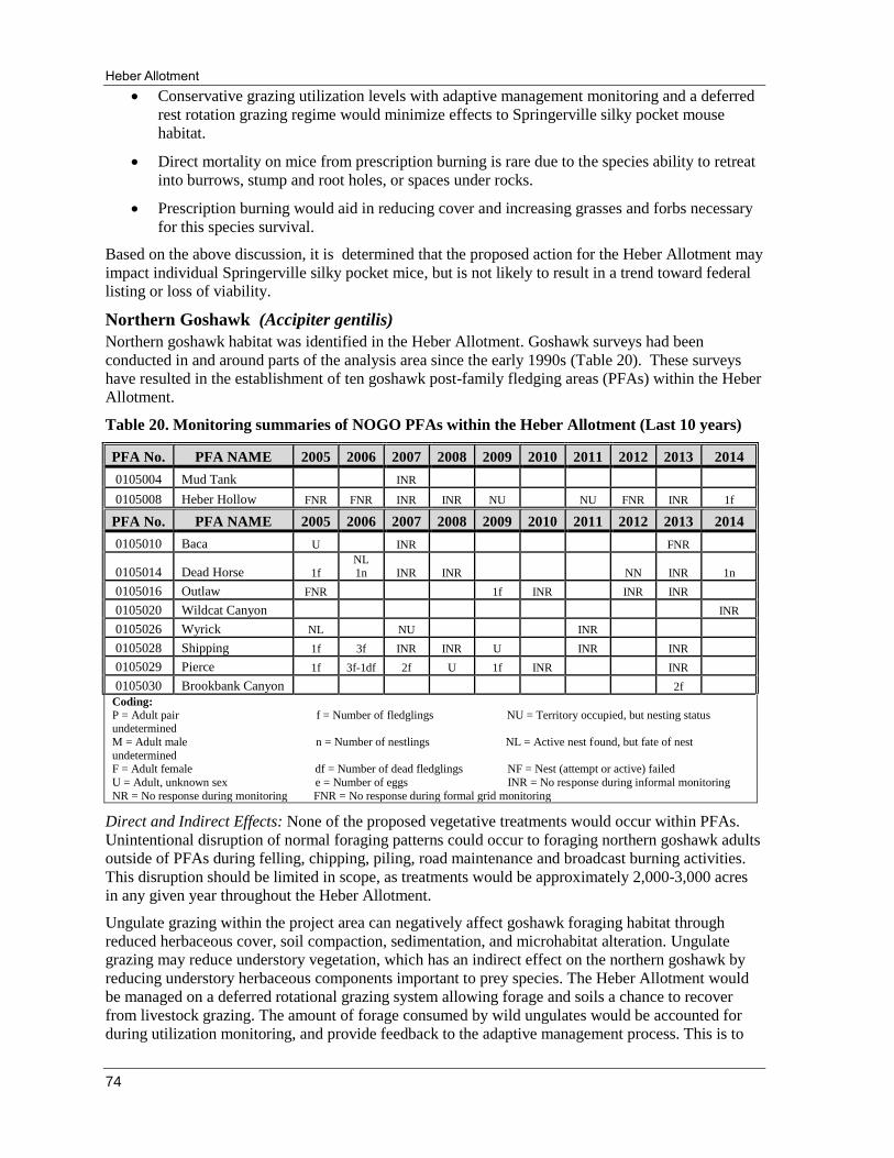
Heber Allotment
74
Conservative grazing utilization levels with adaptive management monitoring and a deferred
rest rotation grazing regime would minimize effects to Springerville silky pocket mouse
habitat.
Direct mortality on mice from prescription burning is rare due to the species ability to retreat
into burrows, stump and root holes, or spaces under rocks.
Prescription burning would aid in reducing cover and increasing grasses and forbs necessary
for this species survival.
Based on the above discussion, it is determined that the proposed action for the Heber Allotment may
impact individual Springerville silky pocket mice, but is not likely to result in a trend toward federal
listing or loss of viability.
Northern Goshawk (Accipiter gentilis)
Northern goshawk habitat was identified in the Heber Allotment. Goshawk surveys had been
conducted in and around parts of the analysis area since the early 1990s (Table 20). These surveys
have resulted in the establishment of ten goshawk post-family fledging areas (PFAs) within the Heber
Allotment.
Table 20. Monitoring summaries of NOGO PFAs within the Heber Allotment (Last 10 years)
PFA No. PFA NAME 2005 2006 2007 2008 2009 2010 2011 2012 2013 2014
0105004 Mud Tank
INR
0105008 Heber Hollow FNR FNR INR INR NU
NU FNR INR 1f
PFA No. PFA NAME 2005 2006 2007 2008 2009 2010 2011 2012 2013 2014
0105010 Baca U
INR
FNR
0105014 Dead Horse 1f NL 1n INR INR
NN INR 1n
0105016 Outlaw FNR 1f INR INR INR
0105020 Wildcat Canyon INR
0105026 Wyrick NL NU INR
0105028 Shipping 1f 3f INR INR U INR INR
0105029 Pierce 1f 3f-1df 2f U 1f INR INR
0105030 Brookbank Canyon 2f
Coding:
P = Adult pair f = Number of fledglings NU = Territory occupied, but nesting status undetermined
M = Adult male n = Number of nestlings NL = Active nest found, but fate of nest
undetermined F = Adult female df = Number of dead fledglings NF = Nest (attempt or active) failed
U = Adult, unknown sex e = Number of eggs INR = No response during informal monitoring
NR = No response during monitoring FNR = No response during formal grid monitoring
Direct and Indirect Effects: None of the proposed vegetative treatments would occur within PFAs.
Unintentional disruption of normal foraging patterns could occur to foraging northern goshawk adults
outside of PFAs during felling, chipping, piling, road maintenance and broadcast burning activities.
This disruption should be limited in scope, as treatments would be approximately 2,000-3,000 acres
in any given year throughout the Heber Allotment.
Ungulate grazing within the project area can negatively affect goshawk foraging habitat through
reduced herbaceous cover, soil compaction, sedimentation, and microhabitat alteration. Ungulate
grazing may reduce understory vegetation, which has an indirect effect on the northern goshawk by
reducing understory herbaceous components important to prey species. The Heber Allotment would
be managed on a deferred rotational grazing system allowing forage and soils a chance to recover
from livestock grazing. The amount of forage consumed by wild ungulates would be accounted for
during utilization monitoring, and provide feedback to the adaptive management process. This is to

Environmental Assessment
75
ensure adequate residual groundcover remains at the end of the growing season to protect soil and
water resources and provide for prey species habitat requirements.
Cumulative Effects: Past, present, and reasonably foreseeable future activities expected to
cumulatively affect Northern goshawks include past, present and future timber sales and restoration
projects; prescribed fire; ungulate grazing; recreational activities and Travel Management Rule;
powerline maintenance; road maintenance; and HWHT.
Past timber sales and prescribed burning may have affected northern goshawks through even-aged
forest management in nesting and foraging habitat. Current timber sales and restoration projects meet
goshawk guidelines for forest structure in nesting and foraging habitat (Reynolds et al 1992). All
projects adhered to northern goshawk timing restrictions and likely did not directly affect any resident
goshawks. Present projects focus on uneven-aged management and also adhere to goshawk guidelines
identified in the Forest Plan. All present and future activities are designed to move these habitats
towards historic conditions, which would increase potential habitat quality and quantity and reduce
the hazard of high severity wildfire.
Ungulate grazing in the past had the potential to affect northern goshawk foraging habitat (see
discussion under Direct and Indirect Effects).
Recreational activities may be high during the spring, summer, and fall months in some areas of the
Heber Allotment. Goshawks may avoid areas where people congregate to camp. Recreational off-
road driving may directly affect goshawks when occurring within PFAs during the breeding season.
Travel Management Rule is likely to decrease motorized use across the ASNFs. This would be very
beneficial to breeding goshawks when cross-country travel is reduced in nesting and foraging
habitats.
Goshawks likely forage within the powerline corridor due to the presence of preferred habitat
elements for some prey species; therefore, corridor maintenance may cause short-term impacts to
goshawks as they avoid those areas for foraging and as habitat is temporarily disturbed. However, the
clearing of encroaching conifers within the powerline is short-term and herbaceous vegetation
improves creating favorable conditions for prey.
Road Maintenance may indirectly affect foraging goshawks. Goshawks likely avoid areas undergoing
road maintenance. This may occur only once or twice a year and is short-term.
The HWHT would likely contribute to a reduction in herbaceous vegetation in the project area. This
may cumulatively impact goshawk prey species and indirectly affect northern goshawk foraging.
Effects Determination: The determination of effects for the northern goshawk and its habitat are
based on the above discussion and the following:
There are 10 established northern goshawk PFAs present within the project area and one
within a ½ mile buffer of the allotment (Bear Springs PFA).
All proposed vegetative treatments would occur outside of goshawk PFA’s.
Goshawks are expected to avoid foraging in areas where project activities take place.
Project activities will only occur on approximately 2,000-3,000 acres in any given year
and should limit disruption.
Treatments within piñon-juniper woodlands would be managed for moving towards Forest
Plan requirements with a mixture of aged/size class of trees within a mosaic of openings and
tree groups.
An increase in herbaceous and shrub understory would result from treatments and provide
more forage and cover for northern goshawk prey species post treatment.
Heber Allotment
76
Based on the above discussion, it is determined that the proposed action for the Heber Allotment may
impact individuals of northern goshawk but would not result in a trend toward listing or loss of
viability.
American Peregrine Falcon (Falco peregrinus anatum)
The American peregrine falcon was removed from the Endangered Species Act’s threatened and
endangered species list in 1999 (USDI 1999). It is now classified as a Region 3 Forest sensitive
species. Range in Arizona: breeds in the state wherever sufficient prey is available near cliffs. Areas
of spectacular cliffs such as the Mogollon Rim, Grand Canyon and Colorado Plateau, contain most of
Arizona's breeding peregrines (AZGF 2002a).
Surveys for peregrine falcons have been conducted along much of the Mogollon Rim adjacent to the
Heber Allotment and in portions of canyons north of the project area. There are two known eyries
along the Mogollon Rim on the Tonto National Forest just southwest of the project area. The mule
Creek Eyrie was last monitored in 2007 and was occupied. Fledglings were observed during an
informal visit to the Al Fulton Eyrie in 2013. While the Heber Allotment itself contains no suitable
nesting habitat, the cliffs along the Rim just south of the project area as well as Chevelon Canyon
immediately west of the project area are excellent habitat. The project area is likely used by peregrine
falcons as foraging habitat. Forest Service policy provides for protection of peregrine falcon eyries
and restrictions on activities during the nesting season. All forested and non-forested habitats in the
Heber Allotment are considered for effects analysis as foraging habitat.
Direct and Indirect Effects: The project area falls within the USFS R3 primary, secondary, and
tertiary management zones policy for de-listing. Primary management zones are an average of 0.5
mile around active nest cliffs, secondary management zones are 0.5 – 2.0 miles, and tertiary
management zones are 3.0 miles from an active cliff. Primary nesting zones are managed to enhance
or be neutral in effects on peregrine nesting activity and prey habitat. Activities within this zone
should occur outside the nesting period (February 1 – August 15). Secondary and tertiary zones are
managed to eliminate potential effects during the nesting season from sources such as aircraft or
explosives, or activities within the line-of-sight of the eyrie.
The project area is within ½ mile of two active peregrine falcon eyries. Implementation of project
activities within the primary management zone would be restricted to periods outside the peregrine
falcon breeding season. Because of the timing restriction there would be no disturbance to the eyries.
The de-listing guidelines for R3 state “habitat maintenance or enhancement of prey species in all
Zones should include consideration of snags and large woody material, hardwood components, and
grass/forb/shrub and seedling successional stages.” Harvesting and burning treatments would alter
foraging habitat by thinning tree densities and reducing existing canopy closures. The post treatment
conditions within piñon-juniper woodlands would provide a variety of foraging habitat and cover for
peregrine falcon prey.
Mechanical treatments and prescribed burning, and other project activities may cause visual or
auditory disturbance to foraging peregrine falcons. Approximately 2,000-3,000 acres would be treated
annually; however, these are short-term effects and would be minimized due to activities being
temporally and spatially separated. This disturbance would be localized, of short duration and low
intensity and may affect individual birds but would not affect the overall distribution or reproduction
of the species.
A fall and winter burning period would reduce any impact to nesting and fledgling peregrine falcons
from broadcast burning activities and smoke as burning would only occur outside the sensitive
reproductive season. Fire and smoke effects from broadcast burning may disturb individual birds
outside of the breeding season but this should be short-term impact and would not adversely affect
peregrine falcon due to implementing a low severity prescription. The loss of snags from burning
could reduce available foraging and nesting habitat for swallows and other songbirds, which are

Environmental Assessment
77
identified prey species. However, some studies (e.g. Saab et al 2007) have found that broadcast
burning often creates enough new snags to replace those that were consumed by the fire. Burning
techniques would be adjusted to retain as many existing snags and logs as possible. Additionally,
because peregrine falcons forage up to 17 miles from nesting cliffs, any snag reduction in the project
area is not expected to cause a significant reduction in prey availability for peregrines in the area.
Peregrine falcon foraging habitat would be altered in some areas by thinning and prescribed burning
activities. Prey populations may be affected by changes in tree densities, canopy closures, and ground
cover. In a study conducted in southwestern ponderosa pine forests, Szaro and Balda (1979) found
that bird abundance and species diversity was higher on “silviculturally cut” areas than on untreated
control areas. The more open understory created by fuel reduction treatments may be advantageous to
species of raptors that prey on birds in open forests and small clearings. Some prey species prefer
more open forests and these species have less cover and can more easily be captured (Pilliod et al
2006). Thinning treatments in the project area are expected to result in more open stands but are not
expected to change small bird abundance significantly.
Ungulate grazing has the potential to affect peregrine falcon foraging habitat. Ungulate grazing within
the project area can negatively affect riparian areas through reduced herbaceous cover, soil
compaction, sedimentation, and microhabitat alteration. The grazing system for the Heber Allotment
is managed on a deferred rotational grazing system allowing forage and soils a chance to recover
from livestock grazing, reducing the potential for cumulative impacts. The amount of forage
consumed by wild ungulates would be accounted for during utilization monitoring, and provide
feedback to the adaptive management process. This is to ensure adequate residual groundcover
remains at the end of the growing season to protect soil and water resources and provide for prey
species habitat requirements.
Cumulative Effects: Past, present, and reasonably foreseeable future activities expected to
cumulatively affect peregrine falcons include past, present, and future timber sales and prescribed
fire; ungulate grazing, recreational activities and Travel Management Rule; road maintenance; and
HWHT.
Past timber sales and prescribed burning may have affected peregrine falcons through even-aged
forest management in nesting and foraging habitat. All present and future timber sales, restoration
projects and prescribed burning are designed to move these habitats towards historic conditions,
which would increase potential habitat quality and quantity and reduce the hazard of high severity
wildfire.
Ungulate grazing in the past had the potential to affect peregrine falcon foraging habitat (see
discussion under Direct and Indirect Effects).
Development is expected to continue in the community of Forest Lakes, Heber-Overgaard, and Show
Low/Pinetop/Lakeside. Increased development is associated with a decrease in available foraging
habitats. An increase in the number of people in an area also increases the potential for falcons to be
hit by cars while foraging near highways and forest roads.
Recreational activities may be high during the spring, summer, and fall months in some areas of the
Heber Allotment. Peregrine falcons may avoid areas where people congregate to camp. Falcons may
also flee areas during recreational shooting activities, which seem frequent within the project area.
Recreational off-road driving may indirectly affect falcons when ATV users drive through and
damage herbaceous vegetation important to falcon prey species. Travel Management should reduce
the number of forest roads crossing through peregrine falcon foraging habitat and keep road users in
designated areas. This activity would eliminate cross country travel, which is likely currently having a
negative effect on peregrine falcon populations by increasing hawk-human interactions and causing
avoidance of some preferred foraging habitats.

Heber Allotment
78
Road Maintenance may indirectly affect foraging peregrine falcons. Falcons likely avoid areas
undergoing road maintenance. This may occur only once or twice a year and is short-term.
The HWHT would likely contribute to a reduction in herbaceous vegetation in the project area. This
may cumulatively impact peregrine falcon prey species and indirectly affect foraging.
Effects Determination: The determination of effects for the American peregrine falcon and its habitat
are based on the above discussion and the following:
There is no known peregrine falcon eyries present in the project area. No suitable nesting cliff
habitat is present. Two active eyries exist adjacent to the project area along the Mogollon
Rim and habitat exists adjacent to the project area along the southern boundary.
No treatment activities are planned within the primary management zone.
Short-term effects may occur during mechanical and prescribed burning treatments but
effects would be minimized due to activities being temporally and spatially separated and
would not affect the overall distribution or reproduction of the species.
Thinning treatments in the project area are expected to result in more open stands but are not
expected to change small bird abundance significantly.
Based on the above discussion, it is determined that the proposed action for the Heber Allotment may
impact individual American peregrine falcons but would not result in a trend toward listing or loss of
viability.
Common Black Hawk (Buteogallus anthracinus)
Common black hawks arrive in Arizona as early as March through April and migrate across the
Mexican border for the winter by mid-October. The bird is an obligate, riparian nester that depends
on mature, relatively undisturbed habitat supported by a permanent flowing stream (AGFD 2013).
Surveys for common black hawks have not occurred on the Black Mesa Ranger District; however,
incidental observations have occurred. The most recent observations were two juvenile (recently
fledged) birds located in Chevelon Canyon west of the Heber Allotment. The project area is likely
used by common black hawks for foraging. Standing pools and stock tanks within the project area are
prime locations for black hawk foraging. All forested and non-forested habitats in the project area are
considered for effects analysis as foraging habitat.
Direct and Indirect Effects: Common black-hawks are unlikely to be directly affected by the proposed
action. Mechanical treatments would not occur in suitable black-hawk nesting and foraging habitat.
Broadcast burning could be implemented in foraging habitat but it would take place in the fall outside
the sensitive reproductive season.
Ungulate grazing has the potential to affect common black hawk foraging habitat. Ungulate grazing
within the project area can negatively affect riparian areas through reduced herbaceous cover, soil
compaction, sedimentation, and microhabitat alteration. The grazing system for the Heber Allotment
is managed on a deferred rotational grazing system allowing forage and soils a chance to recover
from livestock grazing, reducing the potential for cumulative impacts. The amount of forage
consumed by wild ungulates would be accounted for during utilization monitoring, and provide
feedback to the adaptive management process. This is to ensure adequate residual groundcover
remains at the end of the growing season to protect soil and water resources and provide for prey
species habitat requirements.
Conservation measures to protect threatened species and BMPs are designed to minimize downstream
effects on soil and ash movement. The prey base and riparian conditions in canyons downstream of
the project could be affected by sedimentation and ash produced by broadcast burning. The prey most
likely to be affected would be snakes, frogs, fish, and crayfish. Increased sedimentation and ash could

Environmental Assessment
79
affect downstream water chemistry, water quality, and channel stream structure (Rieman et al 2003).
It could also affect interstitial spaces between rocks in a streambed for amphibians to lay eggs, forage,
and hide (Pilliod et al 2003).
A fall and winter burning period would reduce any impact to nesting and fledgling black hawks from
broadcast burning activities and smoke as burning would only occur outside the sensitive
reproductive season. Fire and smoke effects from broadcast burning may disturb individual birds
outside of the breeding season but this should be a short-term impact and would not adversely affect
common black-hawks due to implementing a low severity prescription. Maintenance low severity
broadcast burning would occur every two to ten years, so impacts associated with the initial broadcast
burn treatments would reoccur. Benefits from maintenance treatments would include management
towards increased understory herbaceous species that would benefit common blackhawk prey.
Cumulative Effects: Past, present, and reasonably foreseeable future activities expected to
cumulatively affect common black hawks include past, present and future timber sales and prescribed
fire; ungulate grazing; recreational activities and Travel Management Rule; road maintenance; and
HWHT.
Past timber sales and prescribed burning may have affected common black hawks through even-aged
forest management in nesting and foraging habitat. All present and future timber sales, restoration
projects and prescribed burning are designed to move these habitats towards historic conditions,
which would increase potential habitat quality and quantity and reduce the hazard of high severity
wildfire.
Ungulate grazing in the past had the potential to affect common black hawk foraging habitat (see
discussion under Direct and Indirect Effects).
Recreational activities are high during the spring, summer, and fall months in some areas of the Heber
Allotment. Common black hawks may avoid areas where people congregate to camp. Recreational
off-road driving may indirectly affect black hawks when ATV users drive through and damage
riparian habitats important to common black hawk prey species. Travel Management should reduce
the number of forest roads crossing through common black hawk foraging habitat and keep road users
in designated areas.
Road Maintenance may indirectly affect foraging common black hawks. Hawks likely avoid areas
undergoing road maintenance. This may occur only once or twice a year and is short-term.
The HWHT would likely contribute to a reduction in herbaceous vegetation on lands in the project
area. This may cumulatively impact common black hawk prey species and indirectly affect foraging.
Effects Determination: The determination of effects for the common black hawk and its habitat are
based on the above discussion and the following:
There are no known common black hawk nests within the project area although black-hawk
fledglings have been sighted in Chevelon Canyon indicating that the birds may nest within a
few miles of the project area.
Conservation measures and BMPs should minimize the amount of sediment and ash on
downstream riparian habitat and the effects on common black-hawk prey.
Thinning trees would improve watershed conditions, which may result in increased water
quality and quantity for common black hawk prey.
Broadcast burning would occur in the fall and winter, reducing impacts to nesting and
fledging common black hawks. Smoke may be present in the project area outside of the
breeding season but it is likely to be short-term and transitory in nature.
Heber Allotment
80
Treatments within the project area would be incremental and generally not exceed 2,000-
3,000 acres per year, thus not disturbing all potential habitats in any one single year.
Based on the above discussion, it is determined that the proposed action for the Heber Allotment may
impact individuals of the common black-hawk but would not result in a trend toward listing or loss of
viability.
Bald Eagle (Haliaeetus leucocephalus)
The bald eagle south of the 40th parallel was listed as endangered under the Endangered Species
Preservation Act of 1966, and was reclassified to threatened status on July 12, 1995 (USDI 1995).
Bald eagles were delisted from the Endangered Species Act throughout most of Arizona and the
United States in July 2007 (USDI 2007). The Sonoran Desert population continues to be protected
under ESA as a threatened species (USDI 2008). Bald eagles remain protected by the Bald and
Golden Eagle Protection Act and Migratory Bird Treaty Act. Both acts prohibit “take” of bald eagles.
The U.S. Fish and Wildlife Service (2007) and the AGFD have developed management guidelines for
bald eagle nesting and roosting areas. Region 3 of the Forest Service has agreed via a Memorandum
of Understanding to implement the AGFD’s Conservation Assessment and Strategy for the Bald
Eagle in Arizona.
No breeding bald eagles occur within the Heber Allotment; however, bald eagles have been detected
roosting and foraging at Black Canyon Lake (within the project area) during the summer months.
Should bald eagles begin nesting within the project area steps would be taken to implement
restrictions found in the Conservation Assessment Strategy.
Wintering bald eagles have been observed at Black Canyon Lake as well as foraging on Highway
260. There are no known roost sites in or near the proposed vegetation treatment areas. Where known,
roost trees would be protected from project activities. If bald eagle winter roost sites are discovered in
the project area during project implementation, buffers would be established around the sites
according to guidelines in the Conservation and Assessment Strategy. Activities would be restricted
in accordance with these guidelines.
All forested and non-forested habitats in the project area are considered for effects analysis as
foraging habitat.
Direct and Indirect Effects: There is no effect to nesting eagles since no nests occur within the project
area and proposed vegetative treatments are more than 7 miles from known roost sites (Black Canyon
Lake).
A fall and winter burning period would reduce any impact to nesting and fledgling bald eagles
adjacent to the project area from broadcast burning activities and smoke as burning would only occur
outside the sensitive reproductive season. Fire and smoke effects from broadcast burning may disturb
individual birds outside of the breeding season but this should be a short-term impact and would not
adversely affect bald eagles due to implementing a low severity prescription.
Maintenance low severity broadcast burning would occur every two to ten years, so impacts
associated with the initial broadcast burn treatments would reoccur. Benefits from maintenance
treatments would include management towards desired conditions.
Approximately 2,000-3,000 acres would be treated annually; however, these are short-term effects
and would be minimized due to activities being temporally and spatially separated. This disturbance
would be localized, of short duration and low intensity and may affect individual birds but would not
affect the overall distribution or reproduction of the species.
Ungulate grazing has the potential to affect bald eagle foraging habitat. Ungulate grazing within the
project area can negatively affect riparian areas through reduced herbaceous cover, soil compaction,
sedimentation, and microhabitat alteration. The grazing system for the Heber Allotment is managed
on a deferred rotational grazing system allowing forage and soils a chance to recover from livestock
Environmental Assessment
81
grazing, reducing the potential for cumulative impacts. The amount of forage consumed by wild
ungulates would be accounted for during utilization monitoring, and provide feedback to the adaptive
management process. This is to ensure adequate residual groundcover remains at the end of the
growing season to protect soil and water resources and provide for prey species habitat requirements.
Indirect effects to the bald eagle include effects to eagle habitat, eagle prey species, or prey species
habitat. There are no anticipated adverse effects to prey species or prey species habitat.
Cumulative Effects: Past, present, and reasonably foreseeable future activities expected to
cumulatively affect bald eagles include past, present and future timber sales and prescribed fire;
ungulate grazing; and recreational activities and Travel Management Rule.
Past timber sales and prescribed burning may have affected peregrine falcons through even-aged
forest management in nesting and foraging habitat. All present and future timber sales, restoration
projects and prescribed burning are designed to move these habitats towards historic conditions,
which would increase potential habitat quality and quantity and reduce the hazard of high severity
wildfire.
Ungulate grazing in the past had the potential to affect bald eagle foraging habitat (see discussion
under Direct and Indirect effects).
Recreational activities may be high during the spring, summer, and fall months in some areas of the
Heber Allotment. Recreational activities can impact bald eagles when less tolerant eagles are
disturbed through mere human presence, hiking, fishing, boating, bird-watching, off-road vehicles,
and noise from hunting. Responses range from temporary agitation to flushing to displacement. Nest
abandonment and reproductive failure are possible during the nesting season (Buehler 2000). Another
threat from recreational activities includes entanglement in improperly discarded monofilament by
anglers (Driscoll 2005). Potential prey items become caught in the line and die becoming enticing
food for the eagle thus exposing them to the threat of entanglement or entanglement of young that are
being fed. Eagles perched on lakeshores are also at risk of becoming entangled in discarded
monofilament. Travel Management Rule is likely to decrease motorized use across the ASNFs. This
would be very beneficial to bald eagles when cross-country travel is reduced in foraging habitats.
Effects Determination: The determination of effects for the bald eagle and its habitat are based on the
above discussion and the following:
There are no known breeding areas within the project area. The nearest breeding area is 9
miles to the west of the project area at Woods Canyon Lake. Eagles have been observed
foraging at Chevelon Canyon immediately west of the project area. The area is likely used by
wintering eagles.
Short-term disturbance from project activities could occur to foraging or roosting eagles.
Snags (potential roost trees) would be managed according to Forest Plan guidelines.
Fall and winter broadcast burning would reduce impacts to any breeding eagles adjacent to
the project area.
Broadcast burning is not expected to change the availability of perch sites but some large live
trees may be killed by the activity.
Treatments within the project area would be incremental and generally not exceed 2,000-
3,000 acres per year, thus not disturbing all potential habitats in any one single year.
Project activities are not expected to adversely affect bald eagle prey or prey habitat.
Based on the above discussion, it is determined that the proposed action for the Heber Allotment may
impact individuals of the bald eagle, but is not likely to result in a trend toward federal listing or loss
of viability.
Heber Allotment
82
Northern Leopard Frog (Lithobates pipiens)
The northern leopard frog is the most cold-adapted of all leopard frogs. They generally occupy
permanent waters with rooted aquatic vegetation. These can take the form of ponds, canals, marshes,
springs, and streams. In Arizona, this species occupies elevations between 2,640 to 9,155 feet (AGFD
2002c).
Observations of northern leopard frogs have not occurred in recent years adjacent to or within the
Heber Allotment. One observation occurred within the allotment at Twin Lakes stocktanks in 1984
and 1985, and the most recent observation occurred in Black Canyon in 2004. Surveys for this species
in the Heber Allotment would take place in 2015. Surveys would be conducted annually in areas
identified for treatments. All wetland habitats and stocktanks would be considered breeding habitat
while forested habitats in the project area would be considered as dispersal habitat in regards to the
effects analysis.
Direct and Indirect Effects – Northern leopard frogs may be killed during project activities if caught
outside of the wetland zone during thinning or prescribed burning. Mortality of amphibians is thought
to occur rarely and be of relatively minor importance due to the ability of most amphibians to take
refuge in underground burrows or moist leaf litter (Pilliod et al 2003). Northern leopard frogs likely
take refuge in emergent vegetation of wetland habitats or under water. Northern leopard frogs are
highly mobile; however, they risk desiccation if they escape into areas where nearby water sources do
not exist.
Thinning and prescribed burning would initially result in less favorable conditions for amphibians due
to a reduction of understory vegetation and downed woody debris, which causes warmer temperatures
and dryer conditions in dispersal habitat. This loss of important amphibian cover in microhabitats can
result in exposure to extremes in temperature and desiccation thereby elevating risk of predation or
physiological stress (Pilliod et al 2003). Thinning activities would also increase the amount of runoff
reaching stock tanks within the allotment, providing breeding and dispersal habitat. Amphibians,
such as northern leopard frogs, may be less affected by changes in environmental conditions
associated with thinning because of their tendency to travel at night and during rain events (Pilliod et
al 2006).
Ungulate grazing has the potential to affect northern leopard frogs and their habitats. Livestock may
congregate in wetland ecosystems because of higher forage volumes and palatability of riparian
species, increased water availability, improved upland grazing sites, and cooler temperatures and
shade near riparian/wetland areas. Livestock effect leopard frog habitat components through declines
in the structural richness of the vegetative community, increased aridity of habitat, loss of thermal
cover and protection from predators, and a rise in water temperatures to lethal levels to larval stages
of amphibians. Livestock are also propagators of non-native vegetation, which compete with native
vegetation for water and space, and create fine fuels in vegetation communities not adapted to fire.
This encourages the number and severity of fires across the landscape which affects the suitability of
habitat for the frog by increasing the turbidly of streams and filling important pool habitat, increasing
water temperature, and lowering dissolved oxygen contents. The grazing system for the Heber
Allotment is managed on a deferred rotational grazing system allowing forage and soils a chance to
recover from livestock grazing, reducing the potential for cumulative impacts. The amount of forage
consumed by wild ungulates would be accounted for during utilization monitoring, and provide
feedback to the adaptive management process. This is to ensure adequate residual groundcover
remains at the end of the growing season to protect soil and water resources and provide for prey
species habitat requirements. Stock tanks, if properly managed, can provide habitat suitable for the
northern leopard frog when it remains devoid of non-native species, provides adequate vegetative
cover, and provides reliable water sources in periods of prolonged drought.
The existing road system would experience increased use during project implementation. Higher use
of the road system could result in the interruption of dispersal or direct mortality of northern leopard
Environmental Assessment
83
frogs. This disturbance would most likely be limited to fall and possibly winter months when leopard
frogs are hibernating and would affect only a fraction of the total project area at any one time.
Wetlands may provide refuge from fire and breeding activities may be carried out with little
interruption (Smith 2000); however, thermal stress or rapid changes in water chemistry may result in
mortality of adult and larval amphibian populations of northern leopard frogs. Depending on the size
and type of the water body, water temperature can increase during fires from intense heat of
combustion or after a fire from increased solar radiation (Pilliod et al 2003). Fire intensities within the
wetland areas are expected to be low to non-existent but some poolside vegetation may be consumed.
This can alter the quantity and composition of emergent vegetation within wetlands, which provide
cover for adult frogs, eggs, and tadpoles.
Slash piling and broadcast burning could have indirect effects to aquatic habitat by reducing
surrounding ground cover and increasing sediment flow into stock tanks and drainages.
Sedimentation and nutrient pulses or longer-term loading into lakes and ponds could occur as a result
of project activities, affecting amphibian populations that are sensitive to such changes.
Sedimentation results in a loss of breeding, feeding, and cover habitats for amphibians (Pilliod et al
2003). This would only effect one growing season. Enhanced productivity of the herbaceous and
shrub layers on the forest floor following treatments may create favorable microclimates for prey or
cover (Semlitsch et al 2009).
Approximately 2,000-3,000 acres would be treated annually; however, these are short-term effects
and would be minimized due to activities being temporally and spatially separated. This disturbance
would be localized, of short duration and low intensity and may affect individual frogs but would not
affect the overall distribution or reproduction of the species.
Cumulative Effects: Past, present, and reasonably foreseeable future activities expected to
cumulatively affect northern leopard frogs include past, present and future timber sales and prescribed
fire; ungulate grazing, recreational activities and Travel Management Rule; powerline maintenance;
road maintenance; and HWHT.
Past timber sales and prescribed burning may have affected northern leopard frogs through even-aged
forest management in breeding and dispersal habitat. All present and future timber sales, restoration
projects and prescribed burning are designed to move these habitats towards historic conditions,
which would increase potential habitat quality and quantity and reduce the hazard of high severity
wildfire.
Ungulate grazing in the past may have affected northern leopard frog habitats (see discussion above
under Direct and Indirect effects).
Recreational activities are high during the spring, summer, and fall months in some areas of the Heber
Allotment. Recreational activities can impact northern leopard frogs through mere human presence,
hiking, fishing, and off-road vehicles. Increased human use in northern leopard frog habitat results in
trampling of nearshore vegetation reducing cover for the frog. It also increases the potential for
human-frog interactions, which frequently lead to the capture, injury, or death of the frog. OHV’s
tend to travel more often through undeveloped habitat and often cross directly through water bodies.
This can cause mortality and injury to northern leopard frogs that attempt to cross trails created
through occupied habitat. OHV use may also affect leopard frogs through a reduction in vegetative
cover and plant species diversity and a reduction in infiltration rates by soil compaction leading to
increased erosion and reduced habitat connectivity. Current forest projects, such as Travel
Management Rule, would aid in the reduction of OHV use in areas away from open roads. TMR
should also reduce the number of forest roads crossing through northern leopard frog habitat and keep
road users in designated areas. This activity would eliminate cross country travel, which is likely
currently having a negative effect on frog populations by increasing frog-human interactions, causing
avoidance of some preferred habitats, and trampling of individuals.

Heber Allotment
84
Northern leopard frogs likely utilize the powerline corridor during dispersal. Maintenance of the
corridor may cause short-term impacts to dispersing leopard frogs. Frogs may be killed or injured
during activities. However, the clearing of encroaching conifers within the powerline corridor is
short-term and herbaceous vegetation improves creating increased cover and more favorable
conditions for dispersing frogs.
Road maintenance can affect northern leopard frogs. Northern leopard frogs generally disperse at
night and would likely be unaffected directly by road maintenance activities occurring during the day.
However, maintained roads allow for increased traffic which can kill or injure dispersing frogs the
rest of the year. Roads also fragment and modify habitat allowing for a reduction in the genetic
diversity of amphibians.
The HWHT would likely contribute to a reduction in herbaceous vegetation on lands adjacent to the
project area. This decreases cover and increases soil erosion in breeding habitats such as stock tanks
and riparian areas.
Effects Determination – The effects of this project on the northern leopard frog and its habitat are
based on the above discussion and the following:
No northern leopard frogs have been observed in or adjacent to the project area in recent
years. The most recent observation occurred in Black Canyon in 2004.
Northern leopard frogs could be killed during thinning or prescribed burning if caught outside
the wetland zones. This mortality is assumed to be low due to the ability northern leopard
frogs to take refuge in emergent vegetation of wetland habitats or under water.
A reduction in understory vegetation may provide less favorable conditions to northern
leopard frogs due to a reduction in understory vegetation and downed woody debris resulting
in exposure to temperature extremes and desiccation. This impact to northern leopard frogs
may be mitigated due to the frog’s tendency to travel at night and during rain events. In
addition, enhanced productivity of the herbaceous and shrub layers on the forest floor
following treatments may create more favorable microclimates for cover and prey.
Roads will receive higher traffic volumes than currently occurs, which could result in
interruption of dispersal or direct mortality. This activity would likely be limited to the fall
and winter when frogs are hibernating and would affect only a fraction of the project area at
any one time.
Prescribed fire will be managed for low intensities and will likely not significantly affect
wetland habitats, though some poolside vegetation may be consumed, which provide cover
for adult frogs, eggs, and tadpoles.
Conservative grazing utilization levels with adaptive management monitoring and a deferred
rest rotation grazing regime would minimize effects to northern leopard frog habitat.
Sedimentation and nutrient pulses or longer-term loading into lakes and ponds could occur as
a result of project activities. Invertebrate prey populations may be altered by prescribed fire.
Project activities are expected to benefit northern leopard frogs by restoring historical
mosaics of successional stages, habitat structures, and vegetative species compositions. Small
pools may be created as a result of project activities due to a reduction in forest canopy and
an extension of hydroperiods from reduced evapotranspiration.
Treatments within the project area would be incremental and generally not exceed 2,000-
3,000 acres per year, thus not disturbing all potential habitats in any one single year.
Environmental Assessment
85
Based on the above discussion, it is determined that the proposed action for the Heber Allotment may
impact individuals of the northern leopard frog but would not result in a trend toward listing or loss of
viability.
Little Colorado Sucker (Catostomus sp. 3)
The Little Colorado sucker occupies creeks, small to medium rivers, and impoundments. It can be
predominantly found in pools with abundant cover but also in riffles between 2,200 to 7,100 feet
elevation (AGFD 2001a). Food consists of detrital material, algae and some higher vegetation, and a
substantial proportion of aquatic invertebrates (Minckley 1973).
Chevelon Creek is the only perennial creek that exists near the project area and offers habitat for this
species. Individuals of Little Colorado Sucker were identified in Chevelon Canyon in 2005 upstream
of Chevelon Lake approximately seven miles west of the project area and at Durfee Draw,
approximately four miles west of the project area (McKell 2005). This species was also located
downstream of Chevelon Canyon Lake in 1995 (Lopez et al 1998). All stream habitat located in
Chevelon Creek downstream of the project area (downstream from Wildcat Canyon) are considered
for effects analysis.
Direct and Indirect Effects: No direct effects to the Little Colorado sucker would occur with the
implementation of livestock grazing, proposed vegetation treatments and prescribed fire, and
structural improvements since this species is not present in the project area. Indirect effects to Little
Colorado sucker could occur since it is likely present in the action area based on distribution in the
1990s. Suitable or potential habitat occurs near the project area in Chevelon Creek.
Indirect sediment effects to suitable and potential habitats could occur but these effects should be
minimal and primarily short-term. Habitats may be indirectly affected by elevated sediment delivery
from increased surface erosion generated by ground disturbing activities such as road maintenance
and reconstruction, mechanical harvesting activities, pile burning and broadcast burning throughout
the Chevelon Creek Headwaters watersheds. These activities could indirectly affect Little Colorado
sucker habitat through increased sediment delivery to habitats, which may add to existing substrate
embeddedness and increase stream temperatures. The majority of any increased sediment deposition
is expected to occur in the short term (within 1-2 years after treatment completed) and should be
flushed out during peak flows or when the reservoirs spill. Once the disturbed upland areas have
revegetated those sediment inputs should subside to a discountable level and are not likely to modify
potential or suitable habitats for Little Colorado sucker to the degree that habitats are no longer
suitable or potentially suitable. Strict implementation of streamside management zone restrictions,
designed to protect streams from excessive sediment generated on uplands and on roads, should
prevent any significant deterioration of water quality.
An important habitat component for Little Colorado sucker includes an ample food supply. Since the
species is dependent upon aquatic macroinvertebrates for a major portion of their diet, potential
effects to this group are relevant to sucker habitats. Aquatic macroinvertebrates would be indirectly
affected by project activities that result in increased sediment loading within their habitats. Increased
sediment deposition would likely alter aquatic macroinvertebrate production, although not
significantly. Deleterious changes to stream substrate and/or water quality parameters, related to
increased sediment loading, would likely occur for Chevelon Creek tributaries (Wildcat Canyon) over
the short term, but BMPs have been designed to minimize these effects and would be applied during
project implementation.
Riparian condition which includes stream-bank soil and vegetative stability should not be
significantly affected with implementation of the proposed action. BMPs, including streamside
management zone guidelines, would be implemented to retain the integrity of riparian habitats. It is
unlikely that changes in water quality from ash nutrient loading would occur with the implementation
of prescribed burning. Baker (1990) indicated that studies show that additional nutrients in stream-
flow after burning do not significantly impair the quality of surface waters for municipal purposes but

Heber Allotment
86
more information is needed on effects to riparian communities. Gottfried and DeBano (1990) reported
that although a 1991 prescribed fire conducted on Alpine Ranger District in ponderosa pine habitat
did statistically alter the concentrations of some nutrients in stream water; the changes were too small
to adversely affect water quality. An increase in ash would likely occur after prescribed burning in the
project area, but that the filtering capacity of the stream management zone combined with the burn
prescriptions, which limit the extent and severity of the burns, should keep the input of ash into
stream channels to negligible levels.
Approximately 2,000-3,000 acres would be treated annually; however, these are short-term effects
and would be minimized due to activities being temporally and spatially separated.
Cumulative Effects: Past, present, and reasonably foreseeable future activities expected to
cumulatively affect Little Colorado suckers include past, present and future timber sales and
prescribed fire; ungulate grazing; recreational activities and Travel Management Rule; powerline
maintenance; and road maintenance.
Past timber sales and prescribed burning may have affected Little Colorado suckers through even-
aged forest management in nesting and foraging habitat. All present and future timber sales,
restoration projects and prescribed burning are designed to move these habitats towards historic
conditions, which would increase potential habitat quality and quantity and reduce the hazard of high
severity wildfire.
Ungulate grazing in the past may have affected Little Colorado suckers habitats. Livestock may
congregate in wetland ecosystems because of higher forage volumes and palatability of riparian
species, increased water availability, improved upland grazing sites, and cooler temperatures and
shade near riparian and wetland areas. Livestock effect sucker habitat components through declines in
the structural richness of the vegetative community, increased aridity of habitat, loss of thermal cover
and protection from predators, and a rise in water temperatures. Current grazing systems are managed
on a rotational grazing system to allow forage a chance to recover from livestock grazing, reducing
the potential for cumulative impacts. Wild ungulates have the potential to reduce vegetative
understory and affect plant composition in meadows and riparian areas. However, the amount of
forage consumed by wild ungulates would be accounted for during utilization monitoring, and
provide feedback to the adaptive management process. This is to ensure adequate residual
groundcover remains at the end of the growing season to protect soil and water resources.
Recreational activities are high during the spring, summer, and fall months in some areas of the Heber Allotment. Recreational activities can impact Little Colorado suckers through mere human presence, hiking, fishing, and off-road vehicles. OHV’s tend to travel more often through undeveloped habitat and often cross directly through water bodies. OHV use may affect suckers through a reduction in vegetative cover and plant species diversity and a reduction in infiltration rates by soil compaction leading to increased erosion and sedimentation of streams. Travel Management Rule would aid in the reduction of OHV use in areas away from open roads. High recreation also facilitates the transport of nonnative species into other riparian habitats. Trout, bullfrogs, and crayfish all have the potential to be transported into areas containing Little Colorado suckers, resulting in negative impacts to the fish. Travel Management Rule should also reduce the number of forest roads crossing through drainages and riparian areas and keep road users in designated areas. This activity would eliminate cross country travel, which is likely currently having a negative effect on sucker populations by increasing sediment loads into streams.
Powerline corridor maintenance may cause short-term impacts to Little Colorado suckers. Increased surface erosion is generated by ground disturbing equipment and cause increased sediment delivery to habitats, which may add to existing substrate embeddedness and increase stream temperatures. These effects would be short-term and would dissipate during high flow events.

Environmental Assessment
87
Road maintenance could cause slight sedimentation into streams where roads cross drainages or riparian areas. Maintenance of roads also causes increased traffic, which could further facilitate sedimentation into streams. These sedimentation events are confined only to road areas and likely do not contribute greatly to alterations in stream habitat components.
Effects Determination – The effects of this project on the Little Colorado sucker and its habitat are based on the above discussion and the following:
Project activities will strictly adhere to Streamside Management Zone restrictions, which will
protect streams from excessive sediment generated on uplands and roads and will prevent
significant deterioration of water quality.
Increased sediment delivery to habitats would be short-term and sediment is expected to flush
out during peak flows. Revegetation of disturbed uplands will reduce sediment inputs to
discountable levels and will not likely modify potential or suitable habitats for Little
Colorado suckers.
Increased sediment deposition will likely alter aquatic macroinvertebrate production,
although not significantly and only short-term. BMPs have been designed to minimize these
effects and will be applied during project implementation.
Treatments within the project area would be incremental and generally not exceed 2,000-
3,000 acres per year, thus not disturbing all potential habitats in any one single year.
Based on the above discussion, it is determined that the proposed action for the Heber Allotment may
impact individuals of the Little Colorado sucker but would not result in a trend toward listing or loss
of viability.
Roundtail Chub (Gila robusta)
Roundtail chub is a candidate species that occupies cool to warm water in mid-elevation streams and
rivers where typical adult microhabitat consists of pools up to 6.6 feet deep adjacent to swifter riffles
and runs. Cover is usually present and consists of large boulders, tree root wads, submerged large
trees and branches, undercut cliff walls, or deep water. Smaller chubs generally occupy shallower,
low velocity water adjacent to overhead bank cover. These fish occur at 1,210 to 7,220foot elevation
(AGFD 2002b). The fish is primarily carnivorous with adults feeding on aquatic and terrestrial
insects, filamentous algae, and other fishes, while young feed on small insects, crustaceans, and algae
in quiet backwaters (AGFD 2002b).
Chevelon Creek passes just outside the project area at the far northwest corner of the Allotment
boundary (Wildcat Canyon). Individuals of roundtail chub were identified in Chevelon Canyon in
2005 upstream of Chevelon Lake approximately seven miles west of the project area; at Durfee Draw,
approximately 4 miles west of the project area; and at Chevelon Crossing, approximately 3 miles west
of the project area (McKell 2005). This species was also located downstream of Chevelon Canyon
Lake in 1995 (Lopez et al 1998). All stream habitat located in Chevelon Creek downstream of the
project area are considered for effects analysis.
Direct and Indirect Effects: No direct effects to roundtail chub would occur with the implementation
of the proposed action since the species is not present in the project area. Indirect effects to roundtail
chub could occur since the species is likely present in Chevelon Creek.
Short term and long term effects to habitat are the same as described for Little Colorado sucker.
Habitats could be altered by short term increases in sediment loading into Chevelon Creek resulting in
short-term impacts: higher substrate embeddedness and diminished invertebrate food source.
Significant water quality declines are unlikely. Any short term increases in sediment levels would not
impact species viability.

Heber Allotment
88
Cumulative Effects: Cumulative effects are the same as described for Little Colorado sucker.
Effects Determination: The determination of effects for the roundtail chub and its habitat are based
on the above discussion and the following:
All effects are the same as described for the Little Colorado sucker.
Based on the above discussion, it is determined that the proposed action for the Heber Allotment may
impact individuals of the roundtail chub but would not result in a trend toward listing or loss of
viability.
Arizona Sneezeweed (Helenium arizonicum)
This plant is endemic to north-central Arizona in Coconino, Gila, Apache, and Navajo counties
(AZGF 2005a). It occurs around wet places such as ponds, lakes, and roadside ditches. It can be
abundant in its habitat and does not appear to be grazed even though its habitat can have heavy
grazing impacts. It is vulnerable to drainage or drying of wetlands.
While Arizona sneezeweed has not been documented within the project area, many incidental
observations have occurred just west and southwest of the project area along the wetter areas of
highway 260 west of Forest Lakes.
Direct and Indirect Effects: Since no treatments or structural improvements would occur near where
Arizona sneezeweed habitat is located, there would be no direct effects to this species from vegetative
treatments of structural improvements.
Arizona sneezeweed is thought to be relatively unpalatable to livestock (Fletcher 1978). Therefore,
this species likely does not experience direct pressure from grazing. Indirectly, Arizona sneezeweed
may be impacted when grazing alters environmental factors such as species composition, soil
compaction, nutrient levels, and vegetation structure. Grazing may be more intense in wetland and
meadow habitat where this species occurs. Trampling by livestock may be a common threat to
Arizona sneezeweed. The grazing system for the Heber Allotment is managed on a deferred rotational
grazing system allowing forage and soils a chance to recover from livestock grazing. The amount of
forage consumed by all grazers would be accounted for during utilization monitoring, and provide
feedback to the adaptive management process. This is to ensure adequate residual groundcover
remains at the end of the growing season to protect soil and water resources and provide for multiple
species habitat requirements.
Cumulative Effects: Past, present, and reasonably foreseeable future activities expected to
cumulatively affect Arizona sneezeweed include past, present and future timber sales and prescribed
fire; recreational activities and Travel Management Rule; powerline maintenance; and road
maintenance.
Past projects such as timber harvest and prescribed burning have likely had a positive impact on
Arizona sneezeweed. All of these projects allow for the increase in growth of understory vegetation
such as grasses, forbs, and shrubs, which consequently may provide habitat for this species growth.
Additionally, timber harvest generally includes the development of skid roads, which accumulate
water and create new habitat for this species.
Recreational activities can impact Arizona sneezeweed by human destruction of plants and habitat.
Recreationist can unknowingly trample plants when walking through Arizona sneezeweed habitat.
OHV use is the most detrimental to the species. The species tendency to occur in open boggy
meadows areas makes it vulnerable to OHV that search out those specific areas for their activity. This
can uproot individual plants and destroy habitat where the plants may colonize in the future.
Indirectly, OHV use may also affect Arizona sneezeweed plants through a reduction in vegetative
cover and plant species diversity and a reduction in infiltration rates by soil compaction leading to
increased erosion and reduced habitat quality. Current forest projects, such as Travel Management

Environmental Assessment
89
Rule, would aid in the reduction of OHV use in areas away from open roads. Open roads would
remain suitable habitat for this species. Travel Management should also reduce the number of forest
roads crossing through drainages and riparian areas and keep road users in designated areas. This
activity would eliminate cross country travel, which is likely currently having a negative effect on
Arizona sneezeweed populations by trampling of plants within wetland areas.
Powerline corridor maintenance may cause short-term impacts to Arizona sneezeweed. Maintenance
activities can temporarily destroy individual plants in that may occur in low areas where water
accumulates. Post-treatment, activities may be beneficial to the plant since it prefers disturbed
habitats.
Road maintenance is likely beneficial to plants such as Arizona sneezeweed. Maintenance activities
may uproot individual plants; however, activities that disturb soil and create new habitats in the form
of drainage ditches may increase habitat available to this plant.
Based on the above discussion, it is determined that the proposed action for the Heber Allotment may
impact individuals of the Arizona sneezeweed but would not result in a trend toward federal listing or
loss of viability.
Eastwood Alum Root (Heuchera eastwoodiae)
Habitat for this species is strictly in moist, shaded slopes of ponderosa pine forests and canyons at
elevations between 3,480 and 7,874 feet. It is generally found on rocky clay soils and has been
collected from crevices of basalt boulders and deep basaltic soils (AGFD 2005b).
Surveys for Eastwood alum-root have not been conducted on the Black Mesa Ranger District. The
species has not been documented as occurring within the project area. The Heritage Data
Management System documents a 1985 observation of this species along a trail to Chevelon Creek
near Telephone Ridge (AGFD 2005b) about 10 miles from the western edge of the project area. All
forested habitats in the project area are considered for effects analysis.
Direct and Indirect Effects: It is unlikely Eastwood alum-root would be directly impacted by
mechanical treatments or low severity broadcast burning because treatments would not occur within
ponderosa pine forests. There are no known documentations of fire effects to Eastwood alum-root.
No information can be found on effects of ungulate grazing on this plant. Therefore, this species may
or may not experience impacts from grazing. Indirectly, Eastwood alum-root may also be impacted if
grazing alters environmental factors such as species composition, soil compaction, nutrient levels, and
vegetation structure. Trampling by livestock may be a common threat to this plant. The grazing
system for the Heber Allotment is managed on a deferred rotational grazing system allowing forage
and soils a chance to recover from livestock grazing, reducing the potential for cumulative impacts.
The amount of forage consumed by all grazers would be accounted for during utilization monitoring,
and provide feedback to the adaptive management process. This is to ensure adequate residual
groundcover remains at the end of the growing season to protect soil and water resources and provide
for multiple species habitat requirements.
Cumulative Effects: Past, present, and reasonably foreseeable future activities expected to
cumulatively affect Eastwood alum-root include past, present and future timber sales and prescribed
fire; recreational activities and Travel Management Rule; and road maintenance.
Past projects such as timber harvest and prescribed burning have likely had a positive impact on
Eastwood alum-root. All of these projects allow for the increase in growth of understory vegetation
such as grasses, forbs, and shrubs, which consequently may provide habitat for this species growth.
Recreational activities can impact Eastwood alumroot by human destruction of plants and habitat.
Recreationists can unknowingly trample plants when walking through Eastwood alum-root habitat.
The species tendency to occur on moist, shaded slopes likely provides some level of protection for
Heber Allotment
90
this species from OHV use. Future forest projects, such as Travel Management Rule, would aid in the
reduction of OHV use in areas away from open roads. Open roads would remain suitable habitat for
this species. Travel Management should also reduce the number of forest roads crossing through
drainages and riparian areas and keep road users in designated areas. This activity would eliminate
cross country travel, which is likely currently having a negative effect on Eastwood alumroot
populations by trampling of plants within wetland areas.
Road maintenance occurring above slopes where this plant is likely to occur may impact Eastwood
alum-root through increased sedimentation and runoff from roads during activities and during higher
traffic events associated with higher user comfort roads.
Effects Determination: The determination of effects for the Eastwood alum-root and its habitat are
based on the above discussion and the following:
Forest Service personnel have not conducted surveys of suitable habitat in the project area to
determine presence or absence of the species.
Based on the above discussion, it is determined that the proposed action for the Heber Allotment may
impact individuals of the Eastwood alum-root but would not result in a trend toward federal listing or
loss of viability.
Arizona Alum Root (Huechera glomerulata)
Arizona alum root is located on shaded rocky slopes, in humus soil, near seeps, streams, and riparian
areas at elevations between 4,000 to 9,000 feet, typically on north facing slopes. Associated plant
communities include oak and pine-oak habitats, pinyon juniper woodlands, and ponderosa pine and
mixed conifer forests (AGFD 2004).
Surveys for Arizona alum root have not occurred within the Heber Allotment. No historic records
exist for this species on the Black Mesa Ranger District. Habitat for this species exists within the
project area. For that reason all forested habitats in the project area are considered for effects analysis.
Direct and Indirect Effects: Arizona alum root could be directly impacted by mechanical treatment
and low severity broadcast burning. Mechanical treatments are not expected to significantly affect
Arizona alum root habitat. There are no known documentations of fire effects to Arizona alum root.
Approximately 2,000-3,000 acres would be treated annually; however, these are short-term effects
and would be minimized due to activities being temporally and spatially separated. This disturbance
would be localized, of short duration and low intensity and may affect individual plants but would not
affect the overall distribution of the species.
No information can be found on effects of ungulate grazing on this plant. The grazing system for the
Heber Allotment is managed on a deferred rotational grazing system allowing forage and soils a
chance to recover from livestock grazing, reducing the potential for direct and indirect impacts. The
amount of forage consumed by all grazers would be accounted for during utilization monitoring, and
provide feedback to the adaptive management process. This is to ensure adequate residual
groundcover remains at the end of the growing season to protect soil and water resources and provide
for multiple species habitat requirements.
Cumulative Effects: Past, present, and reasonably foreseeable future activities expected to
cumulatively affect Arizona alum root include past, present and future timber sales and prescribed
fire; ungulate grazing; recreational activities and Travel Management Rule; and road maintenance.
Past projects such as timber harvest and prescribed burning have likely had a positive impact on
Arizona alum root. All of these projects allow for the increase in growth of understory vegetation
such as grasses, forbs, and shrubs, which consequently may provide habitat for this species growth.

Environmental Assessment
91
No information can be found on effects of ungulate grazing on this plant. Grazing systems are
generally managed on a rotational grazing system to allow forage a chance to recover from livestock
grazing, reducing the potential for cumulative impacts. However wild ungulates would continue to
reduce vegetative understory and affect plant composition in Arizona alum root habitat.
Recreational activities can impact Arizona alum root by human destruction of plants and habitat.
Recreationists can unknowingly trample plants when walking through Eastwood alum-root habitat.
The species tendency to occur on moist, shaded slopes likely provides some level of protection for
this species from OHV use. Travel Management Rule should also reduce the number of forest roads
crossing through drainages and riparian areas and keep road users in designated areas. This activity
would eliminate cross country travel, which is likely currently having a negative effect on Eastwood
alumroot populations by trampling of plants within wetland areas.
Road maintenance occurring above slopes where this plant is likely to occur may impact Arizona
alum root through increased sedimentation and runoff from roads during activities and during higher
traffic events associated with higher user comfort roads.
Based on the above discussion, it is determined that the proposed action for the Heber Allotment may
impact individuals of the Arizona alum root but would not result in a trend toward federal listing or
loss of viability.
Arizona Sunflower (Helianthus arizonensis)
The Arizona sunflower occurs in Coconino and Navajo Counties, Arizona in dry, sandy soils ranging
in elevation from 4,000 to 7,000 feet (NMRP, accessed March 5, 2014).
Surveys for Arizona sunflower have not occurred within the Heber Allotment. It is unknown whether
this species exists within the project area. This species is listed in the national plants database
(http://plants.usda.gov/index.html) as occurring on the Sitgreaves National Forest with a photograph
of the location appearing to have been taken within a drainage with dark loamy soils. All forested
and non-forested habitats in the project area are considered for effects analysis.
Direct and Indirect Effects: Upland areas with dry, sandy soils are within locations that would receive
both mechanical treatments and low severity broadcast fire. Individual Arizona sunflower plants that
may exist in these areas could be damaged or removed by mechanical and broadcast fire treatments.
There is no known documentation of fire effects to Arizona sunflower. Broadcast burning could kill
or damage the plants. Benefits from maintenance treatments would include management towards
desired conditions and increased understory herbaceous species.
Approximately 2,000-3,000 acres would be treated annually; however, these are short-term effects
and would be minimized due to activities being temporally and spatially separated. This disturbance
would be localized, of short duration and low intensity and may affect individual plants but would not
affect the overall distribution of the species.
No information can be found on effects of ungulate grazing on this plant. The grazing system for the
Heber Allotment is managed on a deferred rotational grazing system allowing forage and soils a
chance to recover from livestock grazing, reducing the potential for direct and indirect effecs. The
amount of forage consumed by all grazers would be accounted for during utilization monitoring, and
provide feedback to the adaptive management process. This is to ensure adequate residual
groundcover remains at the end of the growing season to protect soil and water resources and provide
for multiple species habitat requirements.
Cumulative Effects: Past, present, and reasonably foreseeable future activities expected to
cumulatively affect Arizona sunflower include past, present and future timber sales and prescribed
fire; ungulate grazing; recreational activities and Travel Management Rule; powerline maintenance;
and road maintenance.

Heber Allotment
92
Past projects such as timber harvest and prescribed burning have likely had a positive impact on
Arizona sunflower. All of these projects allow for the increase in growth of understory vegetation
such as grasses, forbs, and shrubs, which consequently may provide habitat for this species growth.
Arizona sunflower historically evolved with low grazing pressure from wild ungulates occupying
their habitat.
Recreational activities can impact Arizona sunflower by human destruction of plants and habitat.
Recreationist can unknowingly trample plants when walking through Arizona sunflower habitat.
OHV use is the most detrimental to the species. The species tendency to occur in dry, sandy areas
makes it vulnerable to OHVs that search out those specific areas for their activity. This can uproot
individual plants and destroy habitat where the plants may colonize in the future. Indirectly, OHV use
may also affect Arizona sunflower plants through a reduction in vegetative cover and plant species
diversity and a reduction in infiltration rates by soil compaction leading to increased erosion and
reduced habitat quality. Travel Management Rule should also reduce the number of forest roads
crossing through Arizona sunflower habitat and keep road users in designated areas. This activity
would eliminate cross country travel, which is likely currently having a negative effect on Arizona
sunflower populations by trampling of plants.
Powerline corridor maintenance may cause short-term impacts to Arizona sunflower. Maintenance
activities can temporarily destroy individual plants in that may occur in the corridor. Post-treatment,
this activity may benefit Arizona Sunflowers by decreasing canopy cover.
Based on the above discussion, it is determined that the proposed action for the Heber Allotment may
impact individuals of the Arizona sunflower but would not result in a trend toward federal listing or
loss of viability.
Blumer’s Dock (Rumex orthoneurus)
Blumer’s dock is found in mid- to high-elevation (4,480 – 9,660 feet) wetlands with moist, organic
soils generally adjacent to perennial springs or streams in canyons and meadow situations.
Surrounding forested areas are characterized by Madrean Subalpine Grassland meadows (within
Montane Conifer or Mixed Conifer forests) or Interior Southwestern Riparian Deciduous Forest
(AGFD 2002d).
Surveys for Blumer’s dock have occurred within the Heber Allotment. Blumer’s dock has been
documented in Gentry Canyon within the project area and found elsewhere in the Black Mesa Ranger
District outside of the project area (Willow Springs Canyon, Woods Canyon, Double Cabin Draw,
Fairchild Draw, Pius Draw, and Long Tom Canyon).
Direct and Indirect Effects: Since there would be no vegetative treatments or prescribed burning
within the habitats described above for Blumer’s dock, there would be direct or indirect effects from
proposed treatments.
No information can be found on effects of ungulate grazing on this plant. The grazing system for the
Heber Allotment is managed on a deferred rotational grazing system allowing forage and soils a
chance to recover from livestock grazing, reducing the potential for direct and indirect impacts. In
addition, the documented occurrence of Blumer’s dock in Gentry Canyon has been fenced (32.8
acres) to exclude grazing. Another exclosure in Baca Meadows (18.2 acres) may provide an
additional protected area for this species. The amount of forage consumed by all grazers would be
accounted for during utilization monitoring, and provide feedback to the adaptive management
process. This is to ensure adequate residual groundcover remains at the end of the growing season to
protect soil and water resources and provide for multiple species habitat requirements.
Cumulative Effects: Past, present, and reasonably foreseeable future activities expected to
cumulatively affect Blumer’s dock include past, present and future timber sales and prescribed fire;

Environmental Assessment
93
ungulate grazing; recreational activities and Travel Management Rule; powerline maintenance; and
road maintenance.
Past projects such as timber harvest and prescribed burning have likely had a positive impact on
Blumer’s dock. All of these projects allow for the increase in growth of understory vegetation such as
grasses, forbs, and shrubs, which consequently may provide habitat for this species growth.
Blumer’s dock historically evolved with low grazing pressure from wild ungulates occupying their
habitat.
Recreational activities can impact Blumer’s dock by human destruction of plants and habitat.
Recreationist can unknowingly trample plants when walking through Blumer’s dock habitat. OHV
use is the most detrimental to the species. The species tendency to occur in open, wet meadows areas
makes it vulnerable to OHV users that search out those specific areas for their activity. This can
uproot individual plants and destroy habitat where the plants may colonize in the future. Indirectly,
OHV use may also affect Blumer’s dock plants through a reduction in vegetative cover and plant
species diversity and a reduction in infiltration rates by soil compaction leading to increased erosion
and reduced habitat quality. Travel Management Rule should also reduce the number of forest roads
crossing through drainages and riparian areas and keep road users in designated areas. This activity
would eliminate cross country travel, which is likely currently having a negative effect on Blumer’s
dock populations by trampling of plants within wetland areas.
Powerline corridor maintenance may cause short-term impacts to Blumer’s dock. Maintenance
activities can temporarily destroy individual plants in that may occur in low areas where water
accumulates.
Road maintenance activities may uproot individual plants. Increased traffic associated with higher
user comfort roads may also disturb Blumer’s dock that occur near roadways.
Based on the above discussion, it is determined that the proposed action for the Heber Allotment may
impact individuals of the Blumer’s dock but would not result in a trend toward federal listing or loss
of viability.
Bebb’s Willow (Salix bebbiana)
Suitable habitat for Bebb’s willows include borders of mountain streams, swamps, lakes, hillsides,
open meadows, forest margins, and irrigation ditches. Soils where Bebb’s willows colonize tend to be
a variety of cobble, gravel, sand, loam, and clay. Due to their high nutrient requirements, colonized
soils tend to be relatively nutritious. Specifically, Bebb’s willow is a species of seepage areas, wet
meadows, and is often in the headwaters of major drainages or in open upland forests. Ideal habitat
for Bebb’s willows is comprised of ample water and less than ample plant competition and herbivory,
which are highly important to seedling success. Bebb’s willows establish readily in sites disturbed by
fire or flooding due to the opening of the canopy and a reduction in competition for resources such as
sunlight, space, water, and nutrients. As a mature plant, this species is tolerable of drier conditions but
seedlings require ample water and recruitment would cease to grow in areas that have dried out
(NatureServe 2014).
Surveys for Bebb’s willow have occurred within the Heber Allotment. Granfelt (2001) surveyed
portions of the Black Mesa Ranger District in 2001. There are extant populations of Bebb’s willow in
Gentry Canyon and Baca Meadow within the project area. Both of these areas have fence enclosures
to protect Bebb’s willow from grazing (total of about 51 acres).
Direct and Indirect Effects: None of the proposed vegetation treatments or prescribed burning would
occur in Bebb’s willow habitat. Therefore, direct effects to Bebb’s willow plants is not anticipated
from vegetative treatments or prescribed fire.

Heber Allotment
94
The grazing system for the Heber Allotment is managed on a deferred rotational grazing system
allowing forage and soils a chance to recover from livestock grazing, reducing the potential for direct
and indirect impacts. In addition, the documented occurrence of Blumer’s dock in Gentry Canyon has
been fenced (32.8 acres) to exclude grazing. Another exclosure in Baca Meadows (18.2 acres) may
provide an additional protected area for this species. The amount of forage consumed by all grazers
would be accounted for during utilization monitoring, and provide feedback to the adaptive
management process. This is to ensure adequate residual groundcover remains at the end of the
growing season to protect soil and water resources and provide for multiple species habitat
requirements.
Cumulative Effects: Past, present, and reasonably foreseeable future activities expected to
cumulatively affect Bebb’s willow include past, present and future timber sales and prescribed fire;
ungulate grazing; recreational activities and Travel Management Rule; powerline maintenance; and
road maintenance.
Past projects such as timber harvest and prescribed burning have likely had a positive impact on
Bebb’s willow. All of these projects allow for the increase in growth of understory vegetation such as
grasses, forbs, and shrubs, which consequently may provide habitat for this species growth.
Bebb’s willow historically evolved with low grazing pressure from wild ungulates occupying their
habitat. Grazing may be more intense in wetland and meadow habitat where this species occurs,
making it even more vulnerable to this practice.
Recreational activities can impact Bebb’s willow by human destruction of plants and habitat.
Recreationist can unknowingly trample seedlings when walking through Bebb’s willow habitat. OHV
use is the most detrimental to the species. The species tendency to occur in open, wet meadows areas
makes it vulnerable to OHV users that search out those specific areas for their activity. This can
uproot individual plants and destroy habitat where the plants may colonize in the future. Indirectly,
OHV use may also affect Bebb’s willow plants through a reduction in vegetative cover and plant
species diversity and a reduction in infiltration rates by soil compaction leading to increased erosion
and reduced habitat quality. Travel Management Rule should also reduce the number of forest roads
crossing through drainages and riparian areas and keep road users in designated areas. This activity
would eliminate cross country travel, which is likely currently having a negative effect on Bebb’s
willow populations by trampling of plants within wetland areas.
Road maintenance occurring above slopes where this plant is likely to occur may impact Bebb’s
willow through increased sedimentation and runoff from roads during activities and during higher
traffic events associated with higher user comfort roads.
Based on the above discussion, it is determined that the proposed action for the Heber Allotment may
impact individuals of the Bebb’s willow but would not result in a trend toward federal listing or loss
of viability.
Arizona Phlox (Phlox amabilis)
Arizona phlox is found on open, exposed, limestone-rocky slopes within pinyon-juniper woodlands
and pine-oak communities at elevations between 3,500 to 7,800 feet (AGFD 2005c).
Surveys for Arizona phlox have not occurred within the Heber Allotment. This species has not been
documented as occurring anywhere within the Black Mesa Ranger District. Suitable habitat exists
within the project area. All pinyon-juniper woodland habitat in the project area are considered for
effects analysis.
Direct and Indirect Effects: Limestone outcrops on slopes within pinyon-juniper woodlands are
limited within areas proposed for treatments; therefore, mechanical treatments are not expected to
affect Arizona phlox on a large scale. Individual Arizona phlox plants that exist in these areas could
be damaged or removed by mechanical treatments. There are no known documentations of fire effects

Environmental Assessment
95
to Arizona phlox. However, limestone outcrops may not have enough fuels to carry a broadcast fire
and plants would therefore be protected.
Approximately 2,000-3,000 acres would be treated annually; however, these are short-term effects
and would be minimized due to activities being temporally and spatially separated. This disturbance
would be localized, of short duration and low intensity and may affect individual plants but would not
affect the overall distribution of the species.
No information can be found on effects of ungulate grazing on this plant. The grazing system for the
Heber Allotment is managed on a deferred rotational grazing system allowing forage and soils a
chance to recover from livestock grazing, reducing the potential for direct and indirect effects. The
amount of forage consumed by all grazers would be accounted for during utilization monitoring, and
provide feedback to the adaptive management process. This is to ensure adequate residual
groundcover remains at the end of the growing season to protect soil and water resources and provide
for multiple species habitat requirements.
Cumulative Effects: Past, present, and reasonably foreseeable future activities expected to
cumulatively affect Arizona phlox include past, present and future timber sales and prescribed fire;
ungulate grazing; recreational activities and Travel Management Rule; powerline maintenance; and
road maintenance.
Past projects such as timber harvest and prescribed burning have likely had a positive impact on
Arizona phlox. All of these projects allow for the increase in growth of understory vegetation such as
grasses, forbs, and shrubs, which consequently may provide habitat for this species growth.
Arizona phlox historically evolved with low grazing pressure from wild ungulates occupying their
habitat.
Recreational activities can impact Arizona phlox by human destruction of plants and habitat.
Recreationist can unknowingly trample plants when walking through Arizona phlox habitat. OHVs
are not able to access Arizona phlox habitat safely and are likely not a problem for this species.
Travel Management Rule should also reduce the number of forest roads crossing through drainages
and riparian areas and keep road users in designated areas. This activity would eliminate cross
country travel, which is likely currently having a negative effect on Arizona phlox populations by
trampling of plants.
Powerline corridor maintenance may cause short-term impacts to Arizona phlox. Maintenance
activities can temporarily destroy individual plants in that may occur in the corridor. Post-treatment,
this activity may benefit Arizona phlox by decreasing canopy cover.
Road maintenance activities may uproot individual plants. Increased traffic associated with higher
user comfort roads may also disturb Arizona phlox that occur near roadways.
Based on the above discussion, it is determined that the proposed action for the Heber Allotment may
impact individuals of the Arizona phlox but would not result in a trend toward federal listing or loss
of viability.
Management Indicator Species – Effects Analysis
The effects analysis that follows is based on implementation of livestock grazing, range structure
improvements, piñon-juniper woodland and grassland maintenance vegetation treatments, and
prescribed burning within the Heber Allotment. Many mitigation measures and design criteria are
incorporated into the effects analysis.
Although the Forested Cover Types cover the majority (53%) of the project area, the species that
inhabit woodland and grassland habitats have the potential to be most affected, both positively and
negatively, by the action alternative.
Heber Allotment
96
No Forest Habitat Cover Type would be converted to another Forest Habitat Cover Type for any MIS
under the No Action or Action alternative.
The following is a description of each MIS considered for the analysis area. The narratives are based
on the current habitat availability, species habitat requirements, and recommendations for maintaining
or improving habitat components for each individual species.
The actions proposed in the action alternative are not expected to result in a reduction in habitat
suitability or a loss of viability for mule deer, Rocky Mountain elk, juniper titmouse, or pronghorn
antelope Forest-wide.
Mule Deer
Mule deer were selected as a management indicator species for early successional habitat in forested
habitat types. The Forest Plan EIS did not define or describe early succession habitat with regard to
MIS. Early succession generally refers to forested habitats in the non-stocked or seedling/sapling
stages of regeneration. Natural or anthropogenic events that result in the creation of early successional
habitat embedded in a matrix of older forest stands that provide sufficient security cover would
ultimately benefit mule deer (Watkins et al 2007).
The mule deer (Odocoileus hemionus) is a wide-ranging species in North America and is listed as
globally secure and common throughout its range (Heritage Global Status Rank G5; NatureServe
2014). In Arizona, the mule deer population is considered secure. The population peaked during the
mid-1980s in response to favorable precipitation and good fawn survival (Watkins et al 2007). Since
the early 1990s the statewide population has been in a decline (Heffelfinger and Messmer 2003).
Currently there appears to be a downward trend in the overall Arizona mule deer population.
Wildfire activity over the past decade would likely improve habitat conditions by creating early
successional habitats that benefit browse production. Although large scale fires, such as the Wallow
Fire in 2011 that burned over 540,000 acres, may not result in the landscape heterogeneity required to
support robust mule deer populations in the short-term, natural succession combined with active
forest restoration designed to create a mosaic of uneven-aged stands would ultimately benefit the
local mule deer population. Additional treatments such as selective harvest, chemical treatment, and
mechanical disturbance could also be implemented to achieve mule deer management goals although
not all treatments are appropriate for all habitat types (Watkins et al 2007). The Heber Allotment
contains about 53,725 acres of early successional habitat for the mule deer.
Mule deer are an indicator species for early-successional habitat (USDA 1987). The Heber Allotment
contains approximately 53,725 acres of suitable habitat for mule deer. Currently, much of the area
supports hiding and thermal cover habitat elements for this species, while foraging habitat falls short
of the recommended amounts.
Alternative 1 – No Action
Habitat Effects – The proposed action would not occur under this alternative, so that piñon-juniper
woodlands would remain overstocked and encroaching into grasslands.
Population Effects – A reduction in habitat associated with overstocked woodlands would limit forage
necessary for mule deer. This lack of foraging habitat would either reduce mule deer reproductive
output or force populations off the Forests. Neither of these would aid in increasing mule deer
population objectives Forest-wide.
Forest Plan Consistency – Based on scientific research, historical information, anecdotal evidence,
and data collected on the ASNFs, the actions proposed in the No Action Alternative are not expected
to result in a reduction in habitat suitability or a loss of viability for mule deer Forest-wide; however,
this alternative is not expected to achieve Forest Plan objectives for habitat and population trends for
mule deer.

Environmental Assessment
97
Effects Determination: The proposed action would result in a small loss of habitat quantity and
quality for mule deer. This decrease in habitat quality is not expected to affect Forest-wide population
and habitat trends.
Alternative 2 – Proposed Action
Habitat Effects: The proposed action would result in about 2-3,000 acres of piñon-juniper woodland
being treated annually. This represents an increase in habitat quantity and quality for mule deer of
about 0.17 percent per year of forest-level habitat (1,769,299 acres forest-wide). This increase in
habitat is not expected to contribute significantly to Forest-wide habitat and population trends. Project
level habitat quantity and quality increase about 5.6 percent per year under the action alternative.
Population Effects: The ASNFs encompasses seven Game Management Units (GMUs) managed by
the Arizona Game and Fish Department. The Arizona Game and Fish Department has provided aerial
survey data for mule deer collected between 2001 and 2011for four GMUs. In unit 27, for example,
the mule deer population appears to be high with annual population estimates averaging 6,562 deer
during this time period and a range of 6,108 to 7,169. In contrast, the combined population estimates
for units 3A and 3C (partially within the Heber Allotment) suggest that while relative low, the mule
deer population is increasing and has been increasing over the past decade (Figure 6). Population
estimates for unit 1 show considerable fluctuation ranging from to 1,053 to 1,278 over the past
decade.
Consistency with Forest Plan: Based on scientific research, historical information, anecdotal
evidence, and data collected on the ASNFs, the actions proposed in the action alternative are not
expected to result in a reduction in habitat suitability or a loss of viability for mule deer Forest-wide.
This alternative is expected to achieve Forest Plan objectives for habitat and population trends for
mule deer.
Effects Determination: The proposed action would result in a small increase in habitat quantity and
quality for mule deer. This increase in habitat is not expected to contribute to Forest-wide habitat and
population trends.
Figure 6. Modeled population estimates for mule deer in GMUs 3A and 3C based on aerial
surveys conducted between 2001 and 2011.
Rocky Mountain Elk
In the ASNFs, elk (Cervus elaphus canadensis) are used as an indicator species for early-succession
forested habitats (AGFD 2012). Elk are widely distributed migratory generalists in Arizona that use a
broad range of habitat types on a seasonal basis. Elk tend to stay on summer range as long as possible
arriving early and remaining until forced down by deep snow. This summer range includes mountain
meadows, ponderosa pine woodlands, spruce-fir forests, and other high-elevation habitats (Edge et al
Heber Allotment
98
1987, Collins and Urness 1983, Boyce et al 2003). Their winter range, generally pinyon-juniper
habitat between 5,500 and 6,500 feet elevation, is more limited in extent and may only comprise 10%
of the animal’s total habitat use. Males have a larger home range (639 km2±465 km
2) than females
(386 km2±313 km
2) and the sexes use habitats differentially (Wallace and Krausman 1997). In the
warm season males utilize spruce forests and clearcuts, while females are found primarily in mixed
conifer habitat types (Wallace and Krausman 1997). During the cold season males are associated with
juniper dominated and juniper removal sites. Females are associated with also use juniper and cleared
juniper sites but also utilize mixed conifer habitat.
Rocky Mountain elk were selected as a management indicator species for their association with early-
successional forest types. Elk primarily forage on grasses, sedges, aster, goosefoot, bear grass,
erigonums, lupines, and other montane plants (Hoffmeister 1986; Boyce et al 2003). Browse items
such as serviceberry, mountain mahogany, sagebrush, rabbitbrush, acorns, and leaves of oaks,
snowberry, and willows may be favored by elk at some times of the year (Korfhage et al 1980,
Collins and Urness 1983). The Forest Plan EIS did not define or describe early succession habitat
with regard to MIS. Early succession generally refers to forested habitats in the non-stocked or
seedling/sapling stages of regeneration. But several of the Forest’s MIS also use mountain grasslands
in similar ways as early-successional forests. Both grasslands and early-succession forests are
affected in like ways by forest management activities. For the purposes of this discussion, both of
these habitat types would be considered early-succession habitat. The Forest Plan EIS shows a total of
145,428 acres of timber in age class 1-40 years old (USDA Forest Service 1987). This age group
represents non-stocked stands (VSS1) and seedling/sapling stands (VSS2). In addition, there were
252,660 acres of mountain and prairie grasslands. Combined, these habitat types totaled 19.8% of the
ASNFs. In 1996, based on Forest Inventory Assessment (FIA) data there were about 244,781 acres of
grasslands and 138,786 acres of non-stocked and seedling/sapling stands, totaling 383,567 acres or
about 19% of the Forest.
Fire serves as the main disturbance regime influencing the age structure and successional stage of the
forests within the ASNFs. Since 2005, approximately 650,000 acres have burned with the most recent
Wallow Fire affecting 540,979 acres. In contrast, forest treatments that favor early successional
development (salvage operations, group selection, seed cuts, etc.) have decreased since 1985.
Compared with forest management prescriptions, wildfire has much greater potential to create early-
succession habitat although catastrophic fires do not appear to result in immediate improvements for
Rocky Mountain elk habitat. For example, the Rodeo-Chediski fire of 2002 burned over 173,000
acres on the Sitgreaves NF and converted approximately 55% of the burn to early-succession habitat
(USDA 2003). However, forage and security cover for big game species such as Rocky Mountain elk
declined after the fire. As a result, the forage capacity for elk declined in the short-term relative to
pre-fire conditions (USDA 2003). In contrast, areas that experienced a moderate- or low-intensity
burn resulted in grass and forb enhancement and created a juxtaposition of food and cover that
benefited Rocky Mountain elk habitat. In summary, low intensity wildfires provide a more immediate
improvement than high intensity wildfires.
Overall habitat condition and trend for Rocky Mountain elk is considered fair and stable. Creating
temporary openings in timbered stands adjacent to high use grazing areas could increase forage in
transitory habitat and decrease grazing impacts to high use areas. Aspen regeneration through patch
cutting and prescribed burning would also increase forage. Private land development and winter range
encroachment as well as harvest would continue to influence population trends.
The ASNFs encompasses seven Game Management Units (GMUs) managed by the Arizona Game
and Fish Department. The Arizona Game and Fish Department has provided aerial survey data for
Rocky Mountain elk collected between 2001 and 2011 for four GMUs. In unit 27 the Rocky mountain
elk annual population estimates averaged 3,370 and varied from a low of 2,988 in 2003 to a high of
3,730 in 2010. In contrast, the combined population estimates for units 3A and 3C suggest that the

Environmental Assessment
99
Rocky Mountain elk populations in this unit are in decline. Population estimates for unit 1 are fairly
stable, averaging 5,870 and varying from a low of 5,411 in 2006 to a high of 6,953 in 2001. The
Heber Allotment contains about 73,913 acres of early successional habitat for Rocky Mountain elk.
Elk are an indicator species for early-successional habitat (USDA 1987). The Heber Allotment
contains approximately 73,913 acres of suitable habitat for Rocky Mountain elk. Currently, much of
the area supports hiding and thermal cover habitat elements for this species, while foraging habitat
falls short of the recommended amounts.
Alternative 1 – No Action
Habitat Effects: The proposed action would not occur under this alternative, so that piñon-juniper
woodlands would remain overstocked in woodlands and encroaching into grasslands.
Population Effects: A reduction in habitat associated with overstocked woodlands would limit forage
necessary for elk. This lack of foraging habitat would either reduce Rocky Mountain elk reproductive
output or force populations off the Forests. Neither of these outcomes would aid in reaching Rocky
Mountain elk population objectives Forest-wide.
Consistency with Forest Plan: Based on scientific research, historical information, anecdotal
evidence, and data collected on the ASNFs, the actions proposed in the No Action Alternative are not
expected to result in a reduction in habitat suitability or a loss of viability for elk Forest-wide.
However, this alternative is not expected to achieve Forest Plan objectives for habitat and population
trends for elk.
Effects Determination: The No Action Alternative would result in a small loss of habitat quantity and
quality for mule deer. This decrease in habitat quality is not expected to affect Forest-wide population
trends; however, the No Action Alternative is expected to contribute to the current downward habitat
trend.
Alternative 2 – Proposed Action
Habitat Effects: The proposed action would result in about 2-3,000 acres of piñon-juniper woodlands
and grasslands being treated annually. This represents an increase in habitat quantity and quality for
Rocky Mountain elk of about 0.18 percent per year of forest-level habitat (1,690,439 acres forest-
wide). This increase in habitat is not expected to contribute significantly to Forest-wide habitat and
population trends. Project level habitat quantity and quality increase about 4.0 percent per year under
the action alternative. This alternative is expected to achieve Forest Plan objectives for habitat and
population trends for Rocky Mountain elk at the project level.
Population Effects: The ASNFs encompasses seven Game Management Units (GMUs) managed by
the Arizona Game and Fish Department. The Arizona Game and Fish Department has provided aerial
survey data for Rocky Mountain elk collected between 2001 and 2011 for four GMUs. In unit 27 the
Rocky mountain elk annual population estimates averaged 3,370 and varied from a low of 2,988 in
2003 to a high of 3,730 in 2010. In contrast, the combined population estimates for units 3A and 3C
(partially within the Heber Allotment) suggest that the Rocky Mountain elk populations in this unit
are in decline. Population estimates for unit 1 are fairly stable, averaging 5,870 and varying from a
low of 5,411 in 2006 to a high of 6,953 in 2001.
Consistency with Forest Plan: Based on scientific research, historical information, anecdotal
evidence, and data collected on the ASNFs, the actions proposed in the action alternative are not
expected to result in a reduction in habitat suitability or a loss of viability for Rocky Mountain elk
Forest-wide. This alternative is expected to achieve Forest Plan objectives for habitat and population
trends for mule deer.
Heber Allotment
100
Effects Determination: The proposed action would result in a small increase in habitat quantity and
quality for Rocky Mountain elk. This increase in habitat is not expected to contribute to Forest-wide
habitat and population trends.
Juniper Titmouse
In the ASNFs, the plain titmouse is an indicator species for snags (USDA 1987, p.134). Sauer et al
(2010) report between 1968 and 2010 there was no significant population trend (0.17, CI -2.29, 2.79)
for the juniper titmouse in Arizona. These trend estimates are summaries of the population change
over the last 44 years, and do not provide information on other patterns of population change.
The ASNFs currently supports 784,532 acres of pinyon-juniper woodland. In order to stimulate trees
to grow larger and improve understory forage, thinning and prescribed burning would be a priority
over the next ten years. Existing habitat for the plain titmouse on the ASNFs is in good condition
with a stable to upward trend.
The removal of pinyon and juniper trees in large blocks has contributed to a decrease in plain
titmouse populations. Breeding bird surveys show that a significant decline of the plain titmouse in
New Mexico occurred between 1966 and 1979. This was likely due to the large areas of pinyon-
juniper that were type converted to grasslands throughout the southwestern U.S. during that period.
More recent surveys show that from 1980 through 1999 the population on a regional scale has
become more stable. As pinyon and juniper return to areas where these trees were cleared, habitat for
the plain titmouse should concordantly increase.
Bird surveys conducted within ASNFs by USFS personnel since 2007 have detected this species on
forest treatments exclusively within pinyon-juniper plots. These surveys determined that this species
is well distributed across the Forest within the pinyon-juniper vegetation association. Survey totals
for juniper titmouse pooled across the entire Forest show a relatively stable number of birds detected
and a high fluctuation in the percent of survey plots where birds were detected. This fluctuation in
detections is most likely an artifact of the low number of survey visits. Taking into account the
continuing occurrence of the juniper titmouse across the Forest in suitable habitat, the abundance and
wide distribution of pinyon-juniper and juniper woodlands across the Forest, stable trends for snag
habitat and pinyon-juniper habitat on the Forest, and the overall population trend across Arizona, it
appears that the Forest supports a well distributed reproducing population of this species. Currently,
juniper titmouse populations on the ASNFs are considered to be stable, and likely near potential. The
Heber Allotment contains about 51,406 acres of late seral/snag component of piñon-juniper woodland
for the juniper titmouse.
In the ASNFs, the plain titmouse is an indicator species for snags (USDA 1987). Sauer et al (2010)
report between 1968 and 2010 there was no significant population trend (0.17, CI -2.29, 2.79) for the
juniper titmouse in Arizona. These trend estimates are summaries of the population change over the
last 44 years, and do not provide information on other patterns of population change. Twenty-two
survey routes were used in this analysis, and the relative abundance of juniper titmice observed per
route was 0.85. These results corroborate the stable trend seen in the nationwide data above. MIS
monitoring efforts on the Black Mesa Ranger District (unpublished data) conducted from 2001-2005
support the status of the juniper titmouse as a relatively common species on the Forest. Juniper
titmice were one of the more common species (n=48, 7, 8, 9, 9) and were seen where pinyon-juniper
was present.
Alternative 1 – No Action
Habitat Effects: The proposed action would not occur under this alternative, so that piñon-juniper
woodlands would remain overstocked and encroaching into grasslands. This would result in a
decrease in habitat quantity and quality for the plain titmouse.
Population Effects: A reduction in habitat associated with overstocked woodlands would limit
foraging habitat for plain titmouse. This lack of foraging habitat would either reduce plain titmouse
Environmental Assessment
101
reproductive output or force populations off the Forests. Neither of these outcomes would aid in
reaching plain titmouse population objectives Forest-wide.
Consistency with Forest Plan: Based on scientific research, historical information, anecdotal
evidence, and data collected on the ASNFs, the actions proposed in the No Action Alternative are not
expected to result in a reduction in habitat suitability or a loss of viability for plain titmouse Forest-
wide. However, this alternative is not expected to achieve Forest Plan objectives for habitat and
population trends for plain titmouse.
Effects Determination: The No Action Alternative would result in a small loss of habitat quantity and
quality for plain titmouse. This decrease in habitat quality is not expected to affect Forest-wide
population trends; however, the No Action Alternative is expected to contribute to the current
downward habitat trend.
Alternative 2 – Proposed Action
Habitat Effects: The proposed action would result in about 2-3,000 acres of woodlands being treated
annually. This represents an increase in habitat quantity and quality for juniper titmouse of about 0.38
percent per year of forest-level habitat (784,532 acres forest-wide). This increase in habitat is not
expected to contribute significantly to Forest-wide habitat and population trends. Project level habitat
quantity and quality increase about 5.8 percent per year under the action alternative. This alternative
is expected to achieve Forest Plan objectives for habitat and population trends for juniper titmouse at
the project level.
Population Effects: The proposed action would improve piñon-juniper habitat for the juniper
titmouse. Taking into account the continuing occurrence of the juniper titmouse across the Forest in
suitable habitat, the abundance and wide distribution of pinyon-juniper and juniper woodlands across
the Forest, stable trends for snag habitat and pinyon-juniper habitat on the Forest, and the overall
population trend across Arizona, it appears that the Forests support a well distributed reproducing
population of this species. Currently, juniper titmouse populations on the ASNFs are considered to be
stable, and likely near potential.
Consistency with Forest Plan: Based on scientific research, historical information, anecdotal
evidence, and data collected on the ASNFs, the actions proposed in the Action Alternative are not
expected to result in a reduction in habitat suitability or a loss of viability for plain titmouse Forest-
wide. This alternative is expected to achieve Forest Plan objectives for habitat and population trends
for plain titmouse.
Effects Determination: The Action Alternative would result in a small loss of habitat quantity and
quality for plain titmouse. This decrease in habitat quality is not expected to affect Forest-wide
population trends; however, the No Action Alternative is expected to contribute to the current
downward habitat trend.
Pronghorn Antelope (Pronghorn)
Pronghorn are a common and persistent species on the Apache-Sitgreaves NFs, although limited in
number (AGFD 2012). While they occur at densities less than habitat capacity, they are well
distributed across suitable habitat. Most pronghorn on the forests are found in the Great Basin
grassland PNVT (185,523 acres). This cover type has substantial acreage where invaded tree densities
are currently high. In addition, pronghorn are known to travel between grassland habitats through
forest and piñon-juniper woodland areas with lower tree densities. This woodland is represented on
the Heber Allotment at 20,188 acres.
Because most pronghorn spend the greatest majority of their time yearlong in the Great Basin
grassland, this cover type is considered the “indicator habitat” for this MIS. Under existing
Heber Allotment
102
conditions, pronghorn habitat in the Great Basin grassland is highly departed from desired conditions.
Quality of habitat has been reduced by loss of extensive stands of desirable perennial grasses, forbs,
and shrubs, and by encroachment by trees (primarily piñon and juniper). In addition, about two-thirds
of the Great Basin grassland has been converted to a woodland type. Given that pronghorn use some
open wooded areas, it is estimated that, overall, about half of the Great Basin grassland acreage is
unsuitable pronghorn habitat, leaving about 92,762 acres as currently suitable “indicator habitat” for
this management indicator species.
Wildfire activity over the past decade would likely improve habitat conditions by creating early
successional habitats that benefit grazing production. The large scale high intensity fires, such as the
Wallow Fire in 2011 that burned over 540,000 acres, would likely provide an exponential increase in
early successional habitats that would favor pronghorn population growth. However, juniper
encroachment continues to be a leading cause of habitat loss throughout the ASNFs.
The pronghorn (Antilocapra amernicana) is a wide-ranging species in North America (Natureserve
2014). Throughout its range, the species is considered secure (Heritage Global Status: G5; National
Status Rank: N5; Arizona Status Rank: S5). Pronghorn populations in Arizona are apparent stable or
increasing in relation to the large scale wildfires that have converted large tracts of habitat from late
to early-successional habitats that favor pronghorn population growth. The Heber Allotment contains
about 71,594 acres of early successional woodlands for pronghorn antelope.
Alternative 1 – No Action
Habitat Effects: The draft Arizona Statewide Management Plan (AGFD 2011) states that ponderosa
pine encroachment has substantially altered and fragmented areas of the formerly more contiguous
grassland habitat that occurred in the region. They attribute this mainly to fire suppression, which has
resulted in a loss of historic grassland components such as the presence of cool season grass species
and forbs and historic fine fuel components that allowed for the return of appropriate wildfire. Under
Alternative 1, conifer encroachment would continue into meadows and grasslands, reducing habitat
available to pronghorn antelope.
Population Effects: A reduction in habitat associated with conifer encroachment would limit forage
necessary for antelope. This lack of foraging habitat would either reduce antelope reproductive output
or force populations off the Forests. Neither of these would aid in increasing pronghorn antelope
population objectives Forest-wide.
Consistency with Forest Plan: Based on scientific research, historical information, anecdotal
evidence, and data collected on the ASNFs, the No Action Alternative is not expected to result in a
reduction in habitat suitability or a loss of viability for pronghorn antelope Forest-wide. However, this
alternative is not expected to achieve Forest Plan objectives for habitat and population trends for
pronghorn antelope.
Effects Determination: No Action Alternative would result in a small loss of habitat quantity and
quality for pronghorn antelope. This decrease in habitat is not expected to affect Forest-wide habitat
and population trends.
Alternative 2 – Proposed Action
Habitat Effects: The proposed action would result in about 2-3,000 acres of piñon-juniper woodlands
being treated annually. This represents an increase in habitat quantity and quality for pronghorn
antelope of about 0.38 percent per year of forest-level habitat (784,532 acres forest-wide). This
increase in habitat is not expected to contribute significantly to Forest-wide habitat and population
trends. Project level habitat quantity and quality increase about 5.8 percent per year under the action
alternative. This alternative is expected to achieve Forest Plan objectives for habitat and population
trends for juniper titmouse at the project level.

Environmental Assessment
103
Short-term disturbance to antelope by treatment activities would temporarily displace and alter
foraging, resting, and traditionally used areas. Approximately 2,000-3,000 acres would be treated
annually; therefore, effects would be short-term and minimized due to activities being temporally and
spatially separated. Antelope would only experience activity-related disturbance in portions of the
project area at one time.
Maintenance low severity broadcast burning would occur every two to ten years, so impacts
associated with the initial broadcast burn treatments would reoccur. Benefits from maintenance
treatments would include increased herbaceous understory vegetation for quality pronghorn antelope
foraging.
Population Effects: The small populations of pronghorn within the GMU 4B have increased only
slightly in the past few years. Thinning treatments and prescribed fire are imperative in maintaining
some of the open forest structures necessary for pronghorn antelope to increase numbers within this
GMU.
Consistency with Forest Plan: Based on scientific research, historical information, anecdotal
evidence, and data collected on the ASNFs, the actions proposed in the action alternative are not
expected to result in a reduction in habitat suitability or a loss of viability for pronghorn antelope
Forest-wide. This alternative is expected to achieve Forest Plan objectives for habitat and population
trends for pronghorn antelope.
Effects Determination: The proposed action would result in a small increase in habitat quantity and
quality for pronghorn antelope. This increase in habitat is expected to contribute to Forest-wide
habitat and population trends.
Migratory Bird Effects Analysis
Alternative 2 – Proposed Action
Alternative 2 would have short term effects to all bird species that breed within the project area
during prescribed burns or mechanical treatments. Unintentional take may occur with implementing
project related activities from Alternative 2 if activities occur during the breeding season. Vegetative
recovery is not anticipated to occur until after the monsoon season in late July or August. Nest
success for those species breeding within the project area would be greatly reduced. This is a short-
term (one breeding season) impact, and vegetation would recover given average rainfall with the
monsoon and winter moisture to allow for breeding of most species the next spring. Additionally,
activities would only treat approximately 2,000-3,000 acres annually; therefore, effects would be
minimized due to activities being temporally and spatially separated.
Benefits from vegetative treatments and prescribed burning would include management towards
desired conditions and increased herbaceous understory vegetation.
No effects would occur to range-wide populations of migratory bird species dependent on mixed
conifer, ponderosa pine, piñon-juniper woodland, and grasslands because the proposed action would
not affect the suitability of migratory bird habitat.
Take Statement
No intentional take would result from the proposed action of the Heber Allotment. Unintentional take
of individual migratory birds may occur, but will not result in changes to the range-wide populations
of these species.

Heber Allotment
104
Fire and Fuels
Affected Environment
Approximately 76,000 acres of Pinon-Juniper woodlands are being analyzed for fire and fuels
management opportunities as part of the Heber Allotment Environmental Analysis (EA). Of those
76,000 acres prescribed fire is being proposed on approximately 39,000 acres. The acres that would
be treated with fire are located within the proposed grassland acres and acres that would have 10-20%
canopy cover.
Fire Regime Condition Class
Fire Regime Condition Class (FRCC) is a metric that quantifies how departed a system is from
historical conditions in relation to fire and the role fire historically played in that system (Hann and
Bunnell 2001, Hardy et al. 2001, Hann et al. 2004). Ecosystem attributes analyzed to determine
FRCC include vegetation characteristics (species composition, structural stage, stand age, canopy
closure, and mosaic pattern); fuel composition; fire frequency, severity, and pattern.
There are three condition classes:
Condition Class 1: Fire regimes are within an historical range and the risk of losing key
ecosystem components is low. Vegetation attributes (species composition and structure) are
intact and functioning within their historical range.
Condition Class 2: Fire regimes have been moderately altered from their historical range.
The risk of losing key ecosystem components is moderate. Fire frequencies have departed
from historical frequencies by one or more return intervals (either increased or decreased),
resulting in moderate changes to one or more of the following: fire size, intensity and severity
and landscape patterns. Vegetation attributes have been moderately altered from their historic
range.
Condition Class 3: Fire regimes have been significantly altered from their historical range.
The risk of losing key ecosystem components is high. Fire frequencies have departed from
historical frequencies by multiple return intervals. This results in dramatic changes to one or
more of the following: fire size, intensity, severity, and landscape patterns. Vegetation
attributes have been significantly altered from their historical range.
Table 21. FRCC Desired conditions and Alternative Comparison.
Alternatives Compared to Desired Conditions (expressed as a percentage)
Alternative 1 Alternative 2 Desired Conditions
FRCC 1 17% 52% 100%
FRCC 2 5% 0% 0%
FRCC 3 78% 48% 0%
The analyses would compare Fire Regime Condition Class (FRCC) by the percent of the area in
FRCC 1, 2, and 3 between the two alternatives and air quality Impacts of alternative 2.
FRCC Results A fire regime I has a frequent fire interval with low to mixed severity. Fires typically maintained
open areas and replaced or opened up areas that exhibited a more closed canopy. Forests in a fire
regime I are maintained in that state by understory vegetation. Much of the forest structure was open
canopy which resulted in healthy and vigorous understory plants that served as fuel to carry surface
fire through these stands. Stands in FRCC 1 would demonstrate little potential for active crown fire
and would experience relatively little overstory mortality post wildfire. Areas where some canopy
openings can be created and some sunlight can penetrate and invigorate understory forbs and grasses
would have decreased threat of crown fire and would have a re-established understory that could
Environmental Assessment
105
support surface fire. If these areas do not contain a well balanced mix of strata with reproducing fire
resilient species they are still considered departed but not as departed as stands with closed canopy.
These areas are classified as FRCC 2. Fire Regime Condition Class 3 are continuous areas in an even
aged condition with closed canopy are considered very departed from historical conditions. These
areas would not be able to support understory vegetation and have potential for continuous crown
fire. With Alternative 1 approximately 17% of the acres would remain in FRCC class 1, five percent
in FRCC class 2, and 78% would remain in FRCC class 3. With Alternative 2 approximately 52% of
the acres would be in FRCC class 1, with the remaining 48% in the FRCC class 3. Alternative 2
moves toward the desired conditions while Alternative 1 moves away from the desired conditions.
Smoke Five Class 1 airsheds were identified within an 80 mile radius of the project area. Seven communities
were identified as smoke sensitive areas near Heber Allotment project area. No current
nonattainment areas exist within an 80 mile radius. Smoke impacts to the communities of Heber /
Overgaard and Snowflake are almost inevitable therefore consideration for smoke duration and wind
direction should be included in burn plans. Actual results can be found in the fire fuels report.
The Mogollon Rim area is heavily used as a recreation area for many people. This area represents
clear and clean air for many visitors and is important to the continued health of surrounding
communities both economically and physically. Smoke, in general is a nuisance and can be adverse
to health, but is also part of the natural disturbance associated with these types of ecosystems. Two
criterion pollutants, carbon monoxide and particulate matter, are produced in wood smoke and are
regulated by the Clean Air Act. The Arizona State Smoke Management Rule implements the Clean
Air Act and contains regulations that all State and Federal natural resource agencies must follow
before a prescribed burn is ignited.
Both prescribed fire and wildfire would create smoke, however the amount and timing of these smoke
events can be mitigated with prescribed fire. Any prescribed burning would be conducted only with
approved site specific burn plans with standard smoke management mitigation and approvals.
Burning would be conducted in favorable atmospheric conditions so as to minimize effects from
smoke to nearby communities, class 1 airsheds and recreationists. All burning would be conducted
according to the Arizona State Smoke Management rule to mitigate smoke impacts. These
regulations ensure that effects from all burning within the area are mitigated and that Clean Air Act
requirements are met. The three scenarios used in the SASEM analysis of smoke impacts can be used
as a benchmark of the types of conditions and fuel loading burns should be conducted in. In general
south southwest winds are preferable so as to avoid impacting Class 1 airsheds, as are days with good
transport winds and ventilation categories. The communities of Heber / Overgaard and Snowflake
would have the most smoke impacts due to their proximity to the project area and lie line with
prevailing winds, therefore measures to mitigate long durations of smoke should be implemented.
Prescribed fires are initiated under conditions that allow managers control and favorable effects.
Prescribed fires would be conducted when conditions are such that overstory tree mortality would be
low, which leaves much of the live-tree carbon pool intact. This results in less biomass being
combusted than if the area were to burn under higher severity wildfire, therefore less carbon
emissions are expected in controlled situations (Wiedinmyer and Hurteau 2010).
Smoke impacts from wildfires are less easily mitigated. Wildfires primarily occur during summer
months when the Heber Allotment area is most used by recreationists and therefore would most likely
have more of an impact on recreation values. The amount of biomass consumed during a wildfire is
also not easily mitigated, the more biomass is consumed by fire the more smoke would be produced.
When comparing alternatives, alternative 2 proposes prescribed burning which would have an impact
on surrounding communities but in a controllable manner. The outcome of this alternative would
also reduce the amount of biomass available to fire during wildfire which would reduce the impact of

Heber Allotment
106
smoke from such a wildfire. Alternative 1 does not propose any prescribed burning; however, it
would continue to maintain large amounts of biomass available for consumption in the event of a
wildfire which would have direct and most likely uncontrollable impacts on recreation, the 5 class 1
airsheds within 80 miles of the project area and surrounding communities.
Cumulative Effects Vegetation treatments around the communities of Heber/Overgaard have contributed to the current
conditions. Over the past 25 years management near the Heber Allotment project area has included
prescribed burning, wildfires, pile burning, mechanical thinning and various harvests as well as
grazing and wildlife focused projects. The Rodeo-Chediski Fire Prescribed Burn Project overlaps the
Heber Allotment project area. This project is utilizing prescribed fire to move the project area
towards a FRCC 1, and reduce the risk of uncharacteristically intense fire behavior. The combined
effects of these two projects and many foreseeable projects around or near the communities of
Heber/Overgaard, surrounding private land north of the forest boundary and the KV power lines
would provide restoration and fuels reduction and create mosaic stand conditions, allowing for
wildlife habitat and vegetative diversity. This same mosaic would allow for a diversity of fire effects
thereby increasing opportunities for the maintenance of forest structure and function using wildfire
and prescribed fire in the long-term future.
Cultural Resources Affected Environment
The Heber Allotment contains cultural resources representing a human presence which began in the
Late Paleoindian period and continues into the present day. Specific Paleoindian sites have not been
recorded on the Heber Allotment, but diagnostic projectile point types such as Folsom and Clovis
have been documented as isolated surface artifacts on portions of the forests adjacent to the Heber
Allotment (ASNFs inventory and site files). The Archaic period sites on the Heber Allotment are
represented by dispersed artifact scatters, bedrock mortars, rock shelters, and a variety of dart point
types such as Pinto, Jay, Elko, and Gypsum. In general, sites dating to this period are located in all
vegetation zones. Basketmaker II-III period sites are sparser on the Allotment. Most of the sites with
pithouses are found within the pinyon-juniper woodland. Pueblo I period sites include pithouse
villages, above ground habitation structures, and artifact scatters. These sites are generally located
within the pinyon-juniper woodland and within the pine-oak forest.
Habitation of the Heber Allotment dramatically increases during the Pueblo II-early Pueblo III period.
Approximately 70% of all documented sites on the Apache-Sitgreaves National Forests, including the
Heber Allotment, date to this period and are associated with the archaeological cultures identified as
the Mogollon and Anasazi. Some of these sites consist of multiple room blocks of between 30 and 40
rooms with associated features and artifacts. Several of these large sites include great kivas. The
most numerous sites that date to this period are typically one-two room masonry structures, small
room blocks of between 4 to 6 rooms, water control features, and artifact scatters without any surface
features.
During the Pueblo III period there is steep decline in the number of sites on the forests, including the
Heber Allotment, but an increase in the number of rooms per site (Donaldson n.d.). Water and soil-
control features are widespread and far more common than in previous times. Shortly after the
beginning of the Pueblo IV period, Bailey Ruin, a large 200 to 250 room pueblo, located less than 2
miles east of the Allotment, appears to have been inhabited no later than A.D. 1325 (Mills et al.
1999:240). Nearby sites, such as Four mile Ruin, continue to be occupied at least into the mid-1300s.
Environmental Assessment
107
By the mid1400s the Heber Allotment was no longer used for permanent habitation but continued to
be used on a temporary basis by the Zuni, Hopi and Acoma, descendants of the Mogollon and
Anasazi.
The earliest dates for arrival of the Western Apache in the area suggests that they arrived in the 16th
Century, just prior to the Coronado Expedition in A.D. 1540 to 1542. Three archaeological sites
recognized as Apache or Yavapai are found within the Heber Allotment. These locations include
flaked glass artifacts for cutting tools and projectile points along with metal cut from barrel bands
used to make knives and projectile points. Archaeologists disagree on exactly when they arrived and
by what route (Perry 1991:145-152; Towner 1999;4-9; Wilcox 1981), few place the Apache in
Arizona before the Historic period (Gunnerson 1956; Schroeder 1952). However, the Apache
themselves believe that they have always been in what is now Arizona. Apache use generally appears
to have been seasonal and evidence of their presence includes artifact assemblages, temporary brush
structures, and limited activity areas for processing and collecting resources.
Historic Euro-American use of the area begins in the 1860’s and continues to the present. General
George Crook established a supply and transportation route along the Mogollon Rim between Camp
Verde and Fort Apache. This route became known as General Crook’s Road and was used into the
early 1900s and is now a designated National Recreation Trail. A large portion of the General Crook
Trail lies with the Heber Allotment. In 1871, reservations were established at Fort Apache for the
Cibecue and White Mountain Apache, Camp Grant for the San Carlos Apache and White Mountain
Apache and Camp Verde for the Yavapai and Tonto Apache (Corbusier 1969;60-61; Schroeder 1959).
More Euro-American settlers came to the area after the establishment of the reservations. Sheep and
cattle herders set up homesteads within the area. At around the same time Mormon settlers from Utah
led by Jacob Hamblin moved into the area in 1877. Mormons established logging camps at Pinedale
and Taylor and farming communities were established at Clay Springs and Pinedale (Plog 1981b).
The Atlantic and Pacific Railroad reached Holbrook in 1880 and resulted in an economic boom for
the region (Lightfoot 1978). After the arrival of the railroad, sheep and cattle grazing became
widespread throughout the Mogollon Plateau. Lightfoot (1978) notes that populations near the
settlements of Pinedale, Heber and Taylor continued to grow until 1900, along with increased tensions
between the cowboy and Mormon factions. Remains of homesteads, cabins and improvements for
ranching and farming dating to this period are found across the forests, primarily near communities
and within the Heber Allotment.
Environmental Consequences
Alternative 1
This alternative is a “No Action” alternative, wherein livestock are removed from the allotment within
a one-year period and no range improvements would take place. Therefore, the potential for heritage
resources to be either directly or indirectly affected by livestock grazing would be eliminated.
Because of a lack of grazing, ground cover should increase, minimizing the impacts of erosion on
cultural resource sites. Because no new range improvements would be constructed, no ground
disturbing activity with the potential to affect heritage resources would take place.
The maintenance of existing structural improvements (e.g. cattle guards, gates, fences, signs, stock
tanks) that do not involve additional ground disturbance are exempt from further review and
consultation (Region 3 Programmatic Agreement, Appendix A, Exemption E).

Heber Allotment
108
Alternative 2 Alternative 2 is the “Proposed Acton” alternative. Under the proposed action alternative, livestock
grazing would be permitted in such a manner that ground cover is expected to generally increase,
reducing the threats of erosion upon cultural resources. Any ground-disturbing activity associated
with the proposed improvements of the allotment will be surveyed prior to implementation and an
archeologist will be consulted to ensure that the requirements of Section 106 of the National Historic
Preservation Act are met. All historic properties will be avoided during the implementation of the
proposed range improvements, thereby ensuring that there is no detrimental effect upon cultural
resources. If maintenance of existing facilities (fences, roads, tanks, etc.) are found to be in areas that
have not been previously surveyed, archaeological survey will be completed prior to any maintenance
or other project actions within that area. All eligible and unevaluated sites located during new survey
will be flagged and avoided so that no damage is done to historic properties in the project area. All
of the proposed improvements specified in the proposed action will have a heritage resource survey
completed prior to implementation. Completion of such inventories will ensure a determination of
No Effect or No Adverse Effect upon heritage resources.
New construction proposed under the EA will be phased to coincide with the completion of
archaeology inventory. As long as archaeological sites are flagged and avoided by project actions
and the boundaries/proposed treatments covered under the EA do not change, no additional
archaeological inventory and/or consultation is needed. If unidentified sites are encountered during
new construction, all work in that locale shall be halted and the District, Zone or Forest Archaeologist
shall be notified immediately.
Cumulative Effects Since site condition assessments for heritage resources are not available for any time prior to the
introduction of European livestock species to the Southwest, some level of effect is assumed to have
contributed to the current condition of all sites on the Heber allotment. Given the non-renewable
nature of heritage resources – particularly archaeological and historic sites - any portion of them that
has been damaged or removed diminishes their cultural and scientific value permanently. The
missing parts cannot be replaced. Therefore, all effects to heritage resources are considered
cumulative.
The cumulative effects on Heritage resources should take into account all surface-altering actions that
have occurred or are likely to occur within the Heber Allotment Project Area, including damages
from previous firefighting, which includes dozer lines and other suppression measures. Current and
previous Forest Service management activities, public resource procurement and recreational use and
natural processes have impacted Heritage resources. However, the use of standard mitigation
measures (all surface-altering actions will be surveyed prior to undertaking and all Heritage resources
will be identified and flagged for avoidance before any actions take place) will ensure that impacts
will be substantially diminished.
Economics and Social
The majority of the Heber Allotment is located within Navajo County with a small amount in
Coconino County, in eastern Arizona. On the Heber Allotment, livestock grazing contributes to the
livelihood of the permittees and employees. This allotment is an important portion of the permittee’s
ranch operation, in that livestock are moved onto the Forest in spring, then the livestock are taken to
other lands at a lower elevation to winter.

Environmental Assessment
109
Social
Livestock grazing has been part of the Southwest culture for about 400 years, since the entry of the
Spanish explorers, missionaries and settlers, though livestock in the area of the Apache-Sitgreaves
N.F. stayed at very low levels until the arrival of the railroad and the Aztec Land and Cattle Company
during the 1880’s (Abruzzi, 1995). A 1998 survey of permittees, who graze livestock on National
Forests in Arizona, indicates that this group has pursued public and private land ranching for up to 40
years and that some have operated ranches for up to 77 years (Cosgrove C. R., 1998). Recent years
have seen the arrival of some new permittees, a few with no previous ranching background. In a three
county survey (Apache, Navajo, Greenlee), respondents rated the importance of the surrounding
natural environment to the quality of life as a 6 on a scale of 1 to 7 (Cosgrove C., 1998). Recent
growth has resulted in diversification of values brought by newcomers. Retirement and second homes
are increasingly a part of the residential makeup of the counties.
Economics
The allotment borders the community of Heber-Overgaard, which is not incorporated. In the earlier
part of the century, the economic base for the community was based around timber harvesting, forest
products, and ranching. In recent years there has been a change in the percentages that each of the
industries comprise, which would be much lower today then the past. The allotment is basically on
the southwestern portion of the county. The county receives a portion of the Forest Service receipts
which include grazing fees.
An analysis of the effects of the alternatives on social and economic values is shown here. The direct
and indirect effects, as well as cumulative effects are described. While values appear very precise in
measurement, they are based on certain assumptions, thus they serve best as an indicator and general
magnitude of change rather than a precise measurement. Although the costs of these projects appear
to be straight forward, there are “values” that are qualitative in nature for other resource areas such as
watershed improvement, vegetative conditions and wildlife. The following factors are compared to
determine impacts on the economy for each alternative: 1) annual grazing fee receipts, 2) costs that
may be incurred from construction of structural range improvements, 3) costs that may be incurred
for non-structural improvements (grassland maintenance and woodland savanna treatments), 4) cost
to the Forest Service for maintenance of existing structural range improvements.
Summary of Effects
Table 22. Summary of Cost per Alternative
Alternative 1 Alternative 2
Annual Grazing Fee Receipts 0 +$6,542 to $10,260
Cost from new structural
Improvements (Total Cost)
0 -$523,956
Cost of non-structural
improvements (Total Cost)
0 -$3,702,304
Cost of Boundary fence
maintenance to Forest Service
(Annually)
-$240,000 0
Environmental Consequences
Alternative 1- No Action This alternative would have the greatest amount of negative impacts on the permittee and the
discontinuation of grazing would result in a loss of income from the use of Forest Lands. The
permittee could either continue to graze livestock off Forest Service Lands, in which their numbers
Heber Allotment
110
would probably have to decrease and/or they would have to find more land or they might sell their
private lands and get out of ranching in this local area.
With the reduction in employment from no grazing, there would be less income to the supporting
businesses in the community. Although the economic soundness of the Heber-Overgaard community
would remain in tack with this alternative, the potential reduction of employment to a small
community could be felt.
With this alternative the fence maintenance responsibly that is assigned to the Heber Allotment would
be changed to the adjacent permittees, the Forest Service or would not occur. Allotments with
common boundaries with fences include the Wildcat, Black Canyon, Pierce Wash, Park Day, and
Willow Wash. This would increase the workloads for the permittees on those allotments. The Forest
Boundary fence maintenance would be Forest Service responsibility to maintain. The length of these
fences totals approximately 48 miles and could cost $240,000 annually (based on past contracts). The
interior fences would not be maintained, become unusable, and might eventually need to be rolled up.
This would also be a cost of the Forest Service. In addition to the cost of the fence rollup, there
would be the loss of the initial investment/value of the improvement. This alternative over a 10 to 20
year period could be most expensive alternative for the Forest Service, with no financial returns
(grazing fee receipts) and no recognized “values” that are qualitative, such as improved watershed
and vegetative condition and increased waters.
The no action alternative would result in the loss of fees to the U.S. Treasury and annual federal
payments to Navajo County for livestock grazing. This loss, by itself, is not substantial; however, the
county would also not benefit from tax receipts from potential range improvements and the state
would lose tax revenues based on the permittees’ use of federal lands. This alternative would generate
no economic contribution to the local economy from a livestock operation, would not directly or
indirectly provide jobs associated with a livestock operation and would generate no grazing receipts
for the federal treasury, in relationship to the to the Heber Allotment. There would be no economic
benefit to the local economy from wood fiber within this alternative or jobs created from any
treatments within this alternative. Although there would be no benefit to the local economy from
livestock grazing or wood fiber, there would be a benefit from the fence maintenance.
Lifestyle changes of ranch employees in response to loss of income or increased debt could include
decreasing spending, investing more time in other operations as means of alternate income
opportunities and further diversifying operations to make them less dependent upon public land
ranching. With this alternative the possible sale of the ranch/private land would increase, which
could lead to increased housing development/loss of “open space” in that area.
This alternative would have the biggest negative economic impact to the Permittee and their
employees, the community, and county. This alternative moves away from the desired condition and
does not comply with Forest Service Manual direction.
Alternative 2 – Proposed Action The implementation of the proposed action would help to ensure the economic viability of the ranch
associated with the Heber Allotment. As long as the permittees are able to function economically, the
likelihood of selling their private land for developments is greatly diminished. Thus, this alternative
helps to maintain “open spaces” on the ranch associated with the allotment.
It could be expected that livestock numbers would either stay similar to what they have been grazing
or increase with this alternative, in turn means that grazing fees collected and number of jobs either
directly related to the ranch operation or indirectly in the community would stay the same or increase.
Portions of these fees would continue to be returned to the County/Forest for improvements. A local

Environmental Assessment
111
power plant uses forest products to generate electricity. Products proposed in this alternative could be
used for this purpose, which would benefit the local economy. Jobs related to the wood fiber industry
would continue to be provided to the local industry and to service contractors.
The costs of the non-structural improvements such as grassland maintenance and savanna treatments
could be approximately $3.7 million and the costs of the water developments could be approximately
$418,000. Projects such as these have the potential to be multi-financed between several partners,
such as AZGFD, wildlife groups, permittee, and the Forest Service. Cost associated with the
structural improvements that would assist with livestock management, such as corrals and holding
pastures would be funded by the permittee with possibly some assistance, in the form of materials
from the Forest Service. These costs are estimated to be approximately $94,000. Cattleguards would
be funded in large part by the Forest Service, with an estimated cost around $13,000.
This alternative would have the biggest positive impact to the permittee, their employees, the
community and the county. This alternative meets the desired condition and also complies with
Forest Service Manual direction.
Cumulative Effects Decision Notices for Allotment Management Plans signed within the last 10 years on the Black Mesa
Ranger District were reviewed for cumulative effects. The results of this review indicate that these
effects would be minor to either alternative.
Environmental Justice Under Executive Order No. 12898, Environmental Justice strives to ensure that, to the greatest extent
practicable and permitted by law, all populations are provided the opportunity to comment before
decisions are rendered on, are allowed to share in the benefits of, are not excluded from, and are not
affected in a disproportionately high or adverse manner by government programs and activities
affecting human health or the environment. One goal of Environmental Justice is to provide the
opportunity for the minority and low-income populations to participate in planning, analysis, and
decision making that affects their health or environment, including identification of program needs
and designs. The alternatives considered in this analysis would not have a disproportionate impact on
any minority or low income population in the immediate area or within surrounding counties.
Noxious Weeds
Affected Environment
Noxious and invasive weeds can reduce forage for wildlife and livestock, create fire hazards, and can
out compete the native vegetation, because in some cases they have no natural enemies. On the
Heber Allotment there is approximately 300 acres of known noxious weed populations, which
amounts to less than 1% of the Allotment. The densities of these weed species are low and with
population trends downward, thru treatments. In addition to the treatments of these weeds species
(which is not proposed in this project because this has been analyzed under a separate analysis
completed in 2008), preventing the spread of weed, and the early detections of weeds are important to
the weed program and are discussed.
Heber Allotment
112
Effects
Alternative 1
No actions would occur with this alternative so the risk of spread from any activities is basically non-
existent. Although the risk of spread of weeds is non-existent, the ability to identify and locate new
populations is reduced, because there would be no monitoring associated with this alternative.
Alternative 2
There is a low risk of spread of noxious weed from livestock grazing, because grazing use is proposed
at a conservative level that would sustain the current plant population and ground cover. The risk of
spread of noxious weeds from the structural and nonstructural improvements is also low because
these treatments are not within or near any known weed populations. The potential of detecting any
new populations would increase, since monitoring of the actions would occur.

Environmental Assessment
113
Chapter 4 Consultation and Coordination The following Forest Service employees served on the interdisciplinary team to complete the analysis
for this project.
Interdisciplinary Team Members Name Title
Chris James District Ranger, Deciding Official
Dawnee Burson NEPA Coordinator
Andy Habgood Rangeland Management Specialist
David Seery Wildlife Biologist
Paul Brown Hydrologist
Rachael Vaughn Wildlife Biologist (transferred)
Gayle Richardson Silviculturist
Eric Roberson Soils
John Manthei Fuels Specialist
Joseph Martin Sitgreaves Zone Archaeologist
Kendell Hughes Rangeland Management Specialist
Steven Richardson Geographic Information Systems
Coordinator
Grace Hancock Pre-sale Forester
The Forest Service consulted the following individuals, federal, state and local agencies, tribes and
non-Forest Service persons during the development of this environmental assessment:
Federal and State Officials and Agencies Natural Resources Conservation Service
US Fish and Wildlife Service
US House of Representatives – Office of Ann Kirkpatrick
US Senate – Office of Jeff Flake
US Senate – Office of John McCain
Arizona House of Representatives - Office of Bob Thorpe
Arizona House of Representatives – Office of Brenda Barton
Arizona Senate – Office of Chester Crandell (past)
Arizona Department of Environmental Quality
Arizona Department of Transportation
Arizona Game and Fish Department
Arizona State Land Department
Arizona State Historical Preservation Office
Coconino County
Navajo County
Tribes White Mountain Apache Tribe Ft. McDowell Yavapai Indian Nation
San Carlos Apache Tribe Hopi Tribe
Tonto Apache Tribe Navajo Nation
Yavapai-Apache Nation Pueblo of Zuni
Yavapai-Prescott Tribe
Others Scoping list available upon request.

Environmental Assessment
115
All Documents Cited in the EA
Abruzzi, William S. 1995. The Social and Ecological Consequences of Early Cattle Ranching
in the Little Colorado River Basin. Human Ecology, Vol. 23, No. 1, (pp. 75-98).
ADEQ. 2011. Arizona State Implementation Plan (SIP) to Maintain and Improve Air
Quality. Phoenix, AZ.
ADEQ. 2014. 2012 Status of ambient surface water quality in Arizona (Draft). Arizona’s
Integrated 305(b) Assessment and 303(d) Listing Report.
http://www.azdeq.gov/environ/water/assessment/assess.html
Arizona Game and Fish Department [AGFD]. 2001a. Catostomus sp. 3. Unpublished
abstract compiled and edited by the Heritage Data Management System, Arizona Game
and Fish Department, Phoenix, AZ. 4 pp.
Arizona Game and Fish Department [AGFD]. 2001b. Idionycteris phyllotis. Unpublished
abstract compiled and edited by the Heritage Data Management System, Arizona Game
and Fish Department, Phoenix, AZ. 4 pp.
Arizona Game and Fish Department [AGFD]. 2002a. Falco peregrinus anatum. Unpublished
abstract compiled and edited by the Heritage Data Management System, Arizona Game
and Fish Department, Phoenix, AZ. 6 pp.
Arizona Game and Fish Department [AGFD]. 2002b. Gila robusta. Unpublished abstract
compiled and edited by the Heritage Data Management System, Arizona Game and Fish
Department, Phoenix, AZ. 4 pp.
Arizona Game and Fish Department [AGFD]. 2002c. Lithobates pipiens. Unpublished
abstract compiled and edited by the Heritage Data Management System, Arizona Game
and Fish Department, Phoenix, AZ. 6 pp.
Arizona Game and Fish Department [AGFD]. 2002d. Rumex orthoneurus. Unpublished
abstract compiled and edited by the Heritage Data Management System, Arizona Game
and Fish Department, Phoenix, AZ. 6 pp.
Arizona Game and Fish Department [AGFD]. 2003a. Corynorhinus townsendii pallescens.
Unpublished abstract compiled and edited by the Heritage Data Management System,
Arizona Game and Fish Department, Phoenix, AZ. 6 pp.
Arizona Game and Fish Department [AGFD]. 2003b. Euderma maculatum. Unpublished
abstract compiled and edited by the Heritage Data Management System, Arizona Game
and Fish Department, Phoenix, AZ. 9 pp.
Arizona Game and Fish Department [AGFD]. 2005a. Helenium arizonicum. Unpublished
abstract compiled and edited by the Heritage Data Management System, Arizona Game
and Fish Department, Phoenix, AZ. 4 pp.
Arizona Game and Fish Department [AGFD]. 2005b. Heuchera eastwoodiae. Unpublished
abstract compiled and edited by the Heritage Data Management System, Arizona Game
and Fish Department, Phoenix, AZ. 4 pp.
Arizona Game and Fish Department [AGFD]. 2005c. Phlox amabilis. Unpublished abstract
compiled and edited by the Heritage Data Management System, Arizona Game and Fish
Department, Phoenix, AZ. 4 pp.

Heber Allotment
116
Arizona Game and Fish Department [AGFD]. 2011. Arizona statewide pronghorn
management plan: draft.
Arizona Game and Fish Department [AGFD]. 2012. Assessment of Management Indicator
Species, Apache-Sitgreaves National Forest, from 2005 to 2011. Arizona Game and
Fish Department, Phoenix, AZ. 117pp.
Arizona Game and Fish Department [AGFD]. 2013. Buteogallus anthracinus. Unpublished
abstract compiled and edited by the Heritage Data Management System, Arizona Game
and Fish Department, Phoenix, AZ. 7 pp.
Arnold, Joseph F., Donald A. Jameson, and Elbert H. Reid 1964. Effects of Grazing, Fire,
and Tree Control. Fort Collins, CO.
Augustine, D. J., J. F. Cully, Jr., and T. L. Johnson. 2007. Influence of fire on blacktailed
prairie dog colony expansion in shortgrass steppe. Rangeland Ecology and Management
60:538–542.
Baumann, R.W. and G.Z. Jacobi. 2002. Capnia caryi, an interesting new species of winter
stonefly from the American southwest (Plecoptera: Capniidae). Western North American
Naturalist 62(4):484-486.
Baker, M. B., Jr. 1990. Hydrologic and water quality effects of fire. Pages 31-42 in J. S. Krammes, tech. coord. Effects of fire management of southwestern natural resources. Gen. Tech. Rep. RM-191. Fort Collins, CO: U.S. Department of Agriculture, Forest Service, Rocky Mountain Forest and Range Experiment Station.
Boyce, M.S., J.S. Mao, E.H. Merrill, D. Fortin, M.G. Turner, J. Fryxell and P. Turchin. 2003.
Scale and heterogeneity in habitat selection by elk in Yellowstone National Park.
Ecoscience. 10(4):421-431.
Brockway, D.G., Gatewood, R.G., and Paris, R.B. 2001. Restoring grassland savannahs from
degraded pinyon-juniper woodlands: effects of mechanical overstory reduction and slash
treatment alternatives. Journal of Environmental Management (2002) Vol. 64, pages 179-
197. Retrieved 31 October 2014 from www.sciencedirect.com.
Buehler, David A. 2000. Bald Eagle (Haliaeetus leucocephalus), The Birds of North America Online (A. Poole, Ed.). Ithaca: Cornell Lab of Ornithology; Retrieved from the Birds of North America Online: http://bna.birds.cornell.edu/bna/species/506doi:10.2173/bna.506
Chaney, E., W. Elmore, and W.S. Platts. 1990. Livestock grazing on western riparian areas.
Produced for the Environmental Protection Agency by Northwest Resource Information
Center, Inc., Eagle, ID.
Clary, Warren P., and Donald A. Jameson 1981. Herbage Production Following Tree and
Shrub Removal in the Pinyon-Juniper Type of Arizona. Provo, UT.
Clary, Warren P. 1986. Herbage Production and Livestock Grazing. Proceedings from the
Pinyon-Juniper Conference. Reno, NV.
Collins, W.B. and P.J. Urness. 1983. Feeding behavior and habitat selection of mule deer and
elk on northern Utah summer range. The Journal of Wildlife Management. 47(3):646-
663.
Converse, S.J., W.M. Block, and G.C. White. 2006. Small mammal population and habitat
responses to forest thinning and prescribed fire. Forest Ecology and Management
228(263–273).
Environmental Assessment
117
Cosgrove, C. (1998). Public Land Use in Apache, Greenlee and Navajo Counties: Results
of a survey of community interests and values. St. Johns, AZ: Partial funding
provided by Apache County Economic Security Corporation, Greenlee County and
Navajo County.
Cosgrove, C. R. (1998). Economic Impacts of Apache-Sitgreaves National Forests Public
land Ranching. St. Johns, AZ: Funded by Apache County Economic Security
Corporation, Greenlee County Board of Supervisors, Navajo County Board of
Supervisors, with support from the Apache-Sitgreaves National Forest.
Covington, W. and S. Sackett. 1990. Fire effects on ponderosa pine soils and management
implications. In J.S. Crammes (ed.), Effects of fire management of southwestern natural
resources. USDA Tech. Rept. No. RM-191.
Crowley, Ervin, R., Timothy Burton, and Steven J Smith. 2006. Monitoring Streambanks and
Riparian Vegetation-Multiple Indicators. U.S. Department of Interior. BLM Technical
Bulletin No. 2005-02 Version 2. 134 pp.
Debano L.F. and Schmidt, L.J. 1989. Improving southwestern riparian areas through
watershed management. Gen. Tch. Rep. RM-182. Fort Collins, CO: U.S. Department of
Agriculture, Forest Service, Rocky Mountain Forest and Range Experimental Station. 33.
P.
Deboodt, T.L., M.P. Fisher, J.C. Buckhouse, and John Swanson. 2008. Monitoring
Hydrological Changes Related to Western Juniper Removal: A Paired Watershed
Approach. Third Interagency Conference on Research in the Watersheds, 8-11
September 2008, Estes Park CO. p 227-232.
Driscoll, J.T., 2005. Bald Eagle: Haliaeetus leucocephalus. Pages 126-127 in Corman, T.E.
and C. Wise-Gervais. 2005. Arizona Breeding Bird Atlas. The University of New Mexico
Press. Albuquerque, NM. 641 pp.
Edge, D.W., C.L. Marcum, and S.L. Olson-Edge. 1987. Summer habitat selection by elk in
western Montana. The Journal of Wildlife Management. 51(4):844-851.
Fletcher, R. 1978. Helenium arizonicum. USDA Forest Service, Region 3.
Gottfried, G.J. and L.F. DeBano, 1990. Streamflow and water quality responses to preharvest
prescribed burning in an undisturbed ponderosa pine watershed. In: Krammes, J.S. (Ed.),
Effects of fire management of southwestern natural resources. General Technical Report
RM-191. USDA Forest Service, pp. 222– 228.
Granfelt, C. 2001. Salix bebbiana Sarg. on the A-S NFS. Report prepared for the USDA
Forest Service, Apache-Sitgreaves National Forests, Springerville, AZ.
Hann, W.J. D.L. Bunnell. 2001 Fire and land management planning and implementation
across multiple scales. Int. J. Wildland Fire. 10:389-403.
Hann, W.J., A. Shlisky, D. Havlina, K. Schon, S. Barrett, T. DeMeo, K. Pohl, J. Menakis, D.
Hamilton, J. Jones, M. Levesque, and C. Frame. 2004. Interagency Fire Regime
Condition Class Guidebook. Last update June 2008: Version 1.3.0 Available:
www.frcc.gov.
Hardy, C.C., Schmidt, K.M., Menakis, J.M., Samson, N.R. 2001. Spatial Data for National
Fire Planning and Fuel Management. International Journal of Wildland Fire 10:353-372
Heber Allotment
118
Heffelfinger, J. R., and T. A. Messmer. 2003. Introduction. Pages 1-11 in J. C. deVos, Jr., M.
R. Conover, and N. E. Headrick, editors. Mule deer conservation: issues and management
strategies. Beryman Institute Press, Utah State University, Logan UT.
Hoffmeister, D.F. 1986. Mammals of Arizona. University of Arizona Press, Tucson, AZ.
Holechek, Jerry L. Rex D. Pieper and Carlton H. Herbel 1998. Range Management Principles
and Practices, 3RD
Edition. Las Cruces, NM.
Holechek, Jerry L., Hilton Gomez, Francisco Molinar, and Dee Galt 1999. Grazing Studies:
What we’ve Learned. Las Cruces, NM.
Holycross, A.T., W.P. Burger, E.J. Negro, and T.C. Brennan. 2006. Surveys for Thamnophis
eques and Thamnophis rufipunctatus in the Gila River Watershed of Arizona and New
Mexico. A report submitted to Arizona Game and Fish Department.
Houghton, D. C. 2001. Two new species of Lepidostoma rambur (Trichoptera:
Lepidostomatidae) from the western United States. Proceedings of the Entomological
Society of Washington 103(3):541-545.
Johnson, W. M. 1953. Effect of Grazing Intensity Upon Vegetation and Cattle Gains on Ponderosa Pine Bunchgrass Ranges of the Front Range of Colorado. Washington, D.C.
Kalies, E.L., C.L. Chambers, and W.W. Covington. 2009. Wildlife responses to thinning and burning treatments in southwestern conifer forests: a meta-analysis. Forest Ecology and Management. doi:10.1016/j.foreco.2009.10.024.
Kolb, Peter F. 1999. Forestland Grazing: Understory Forage Management. Missoula, MT.
Korfhage, R.C., J.R. Nelson and J.M. Skovlin. 1980. Summer diets of Rocky Mountain elk in
Northeastern Oregon. The Journal of Wildlife Management. 44(3):746-750.
Krueper, D.J. 1993. Effects of land use practices on western riparian ecosystems. Pp. 321-330
in Status and management of Neotropical migratory birds, D.M. Finch and P.W. Stangel
(eds); Gen. Tech. Rep;. RM-229, Fort Collins, CO: U.S.D.A., Forest Service, Rocky
Mountain Forest and Range Experimental Station:422 pp.
Krueper, D.J. 1996. Effects of livestock management on Southwestern riparian ecosystems.
Pp. 281-301 in D.W. Shaw and D.M. Finch (eds.), Desired future conditions for
southwestern riparian ecosystems: bringing interests and concerns together. USDA Forest
Service, General Technical Report, RM-272, Rocky Mountain Forest and Range
Experiment Station, Fort Collins, Colorado, USA.
Latta, M.J., C.J. Beardmore, and T.E. Corman. 1999. Arizona Partners In Flight Bird Conservation Plan. Version 1.0. Nongame and Endangered Wildlife Program Technical Report 142. Arizona Game and Fish Department, Phoenix, AZ.
Loeser, Mathew R., Thomas D. Sisk, and Timothy E. Crews 2007. Impact of Grazing Intensity During Drought in an Arizona Grassland. Flagstaff, AZ.
Lopez, M.A., R.J. Dreyer, and G.R. Gonzales. 1998b. Chevelon Creek fish management report. Statewide Fisheries Investigations, Federal Aid Project F-7-M-40. Arizona Game and Fish Department, Phoenix, AZ.
McKell, M. 2005. Region 1 Roundtail Chub Surveys of Chevelon Creek, August 2005. Arizona Game and Fish Department, Region 1.
Minckley, W.L 1973. Fishes of Arizona. Arizona Game and Fish Department, Phoenix. pp.158-159.
Environmental Assessment
119
NatureServe. 2014. NatureServe Explorer: An online encyclopedia of life [web application]. Version 7.1. NatureServe, Arlington, Virginia. Available http://explorer.natureserve.org. (Accessed: March 17, 2014).
New Mexico Rare Plants [NMRP]. 1999. http://nmrareplants.unm.edu/rarelist_single.php?SpeciesID=94. Accessed: March 5, 2014.
Petryszyn, Y. and R. Sidner. 1994. Bat survey of Apache-Sitgreaves National Forest Chevelon, Heber, Alpine, and Clifton Districts. Apache-Sitgreaves National Forests, Springerville, AZ. 92 pp.
Pilliod, D.S, R.B. Bury, E.J. Hyde, C.A. Pearl, and P.S. Corn. 2003. Fire and amphibians in North America. Forest and Ecology Management. 178: 163-181.
Pilliod, D.S., E. L. Bull, J.L. Hayes, and B.C. Wales. 2006. Wildlife and invertebrate response to fuel reduction treatments in dry coniferous forests in the western United States: a synthesis. Gen. Tech. Rep. RM-GTR-173: 1-25.
Platts, W.S. 1991. Livestock grazing. pp. 389-423 in WRr. Meehan (ed.). Influences of forest
and rangeland management on salmonid fishes and their habitats. American Fisheries
Society Special Publication 19. Bethesda, MD. 751 pp.
Pope, T.L. and W.M. Block. 2010. Effects of prescribed fire on winter assemblages of birds in ponderosa pine forests of northern Arizona. The Southwestern Naturalist 55(1): 22-28.
Potter, Loren D. and John C. Krenetsky 1967. Plant Succession with Released Grazing on New Mexico Range Lands. Albuquerque, NM.
Rieman, B.E., D. Lee, D. Burns, R. Gresswell, M. Young, R. Stowell, P. Howell. 2003.
Status of native fishes in western United States and issues for fire and fuels management.
Forest Ecology and Management. 178(1-2): 197-211.
Rodeo-Chediski Reforestation NEPA Analysis. 2012. Project Record.
Rosen, P.C. and C.R. Schwalbe. 1988. Status of the Mexican and narrow-headed garter
snakes (Thamnophis eques megalops and Thamnophis rufipunctatus rufipunctatus) in
Arizona. Unpubl. report from Arizona Game and Fish Dept. (Phoenix, Arizona) to U.S.
Fish and Wildlife Service, Albuquerque, New Mexico. iv + 50 pp + appendices.
Ruiter, D.E. 2007. Description of the Limnephilus granti (Nimmo) female with a
redescription of the male (Trichoptera: Limnephilidae). Proceedings of the
Entomological Society of Washington 109(1):86-89.
Saab, V., W. Block, R. Russell, J. Lehmkuhl, L. Bate, and R. White. 2007. Birds and burns of
the interior west: descriptions, habitats, and management in western forests. Birds and
Burns Network. Gen. Tech. Rep. PNW-GTR-712: 1-23. USDA Forest Service, Pacific
Northwest Research Station. Portland, OR.
Sauer, J. R., J. E. Hines, and J. Fallon. 2010. The North American Breeding Bird Survey,
Results and Analysis 1966 - 2003. Version 2004.1. USGS Patuxent Wildlife Research
Center, Laurel, MD.
Schuster, Joseph L. 1964. Root Development of Native Plants Under Three Grazing
Intensities. Nacogdoches, TX.
Semlitsch, R.D., Todd, B.D., Blomquist, S.M., Calhoun, A.J.K., Gibbons, J.W., Gibbs, J.P.,
Graeter, G.J., Harper, E.B., Hocking, D.J., Hunter, M.L. Jr., Patrick, D.A., Rittenhouse,
T.A. Green, Rothermel, B.B. 2009. Effects of Timber Harvest on Amphibian

Heber Allotment
120
Populations: Understanding mechanisms from Forest Experiments. BioScience 59: 853–
862. 12pp.
Servoss, J.M. 2014. Current population status of northern Mexican and narrow-headed
gartersnakes in the United States. Arizona Ecological Services Office. U.S. Fish and
Wildlife Service. Phoenix, AZ.
Southwest Endangered Species Act Team [SESA]. 2008. Chiricahua leopard frog (Lithobates
[Rana] chiricahuensis): considerations for making effects determinations and
recommendations for reducing and avoiding adverse effects. U.S. Fish and Wildlife
Service, New Mexico Ecological Services Field Office, Albuquerque, New Mexico. 75
pp.
Smith, J.K. (ed.). 2000. Wildland fire in ecosystems: effects of fire on fauna. Gen. Tech. Rep. RM-GTR-42-vol. 1. USDA Forest Service, Rocky Mountain Research Station. Ogden, UT. 83 p.
Szaro, R.C. and R.P. Balda. 1979. Bird community dynamics in a ponderosa pine forest.
Studies in Avian Biology No. 3. Cooper Ornith. Soc. 66 pp.
Taylor, D.A.R. 2006. Forest Management and Bats. Bat Conservation International. 16 pp.
Thorne, M.S., P.J. Meiman, Q.D. Skinner, M.A. Smith, and J.L. Dodd. 2005. Clipping
frequency affects canopy volume and biomass production in planeleaf willow (Salix
planifolia var. planifolia Prush). Rangeland Ecology and Management 58(1):41–50.
Uresk, D. W., J. G. MacCracken, and A. J. Bjugstad. 1982. Prairie dog density and cattle
grazing relationships. Pages 199-201 in Fifth Great Plains wildlife damage control
workshop proceedings, 13-15 October 1982, University of Nebraska, Lincoln.
United States Department of Agriculture 1964. The Pinyon-Juniper Type of Arizona:
Effects of Grazing, Fire, and Tree Control. Fort Collins, Co.
USDA Forest Service. 1987 (amended 2009). Apache-Sitgreaves National Forests Land and
Resource Management Plan, USDA Forest Service, Southwestern Region.
USDA 1989. Terrestrial Ecosystems Survey of the Apache-Sitgreaves National Forests.
Albuquerque, NM.
USDA Forest Service. 2003. Final Environmental Impact Statement for the Rodeo-Chediski
Fire Salvage Project. USDA Forest Service, Apache-Sitgreaves NF, Springerville, AZ.
USDA Forest Service. 2005. Framework for streamlining informal consultation for livestock
grazing activities. 116 pp.
USDA-Forest Service. 2011. Regional Riparian Mapping Project-DRAFT Mapping
Protocols. U.S. Forest Service Southwestern Region. 11pp.
USDA Forest Service. 2012. Management indicator species assessment. Apache-Sitgreaves
National Forests. Springerville, AZ.
USDA, Natural Resources Conservation Service and University of Arizona, Water Resources
Research Center (NRCS and UA). 2007. Carrizo creek watershed – Arizona: rapid
watershed assessment. 38 pp.
USDI Fish and Wildlife Service. 1982. Mexican Wolf Recovery Plan. U.S. Fish and Wildlife
Service, Albuquerque, New Mexico. 103 pp.

Environmental Assessment
121
USDI Fish and Wildlife Service. 1995. Endangered and threatened species; bald eagle reclassification; final rule. Fish and Wildlife Service, Federal Register. 60(133): 36000-36010.
USDI Fish and Wildlife Service. 1995. Recovery plan for the Mexican Spotted Owl (Strix
occidentalis lucida). Vol. I. USDI Fish and Wildlife Service, Albuquerque, New Mexico,
USA.
USDI Fish and Wildlife Service. 1999. Endangered and wildlife and plants; final rule to
remove the American peregrine falcon from the federal list of endangered and threatened
wildlife, and to remove the similarity of appearance provision for free-flying peregrines
in the conterminous United States; final rule. Fish and Wildlife Service, Federal Register.
64(164): 46542-46558.
USDI Fish and Wildlife Service. 2004. Final designation of critical habitat for the Mexican
spotted owl; final rule. Fish and Wildlife Service, Federal Register. 69(168): 53182-
53298.
USDI Fish and Wildlife Service. 2007. Removing the Bald Eagle in the Lower 48 States from
the List of Endangered and Threatened Wildlife, Final Rule, Federal Register. 72
(130):37346-37372.
USDI Fish and Wildlife Service. 2008. Birds of Conservation Concern 2008. United States
Department of Interior, Fish and Wildlife Service, Division of Migratory Bird
Management,
Arlington, Virginia. 85 pp. [Online version available at
<http://www.fws.gov/migratorybirds/>]
USDI Fish and Wildlife Service. 2008b. 12-month finding on a petition to list the Gunnison’s
prairie dog as Threatened or Endangered. Federal Register. 73(24): 6660-6684.
USDI Fish and Wildlife Service. 2012. Final recovery plan for the Mexican spotted owl (Strix
occidentalis lucida), first revision. U.S. Fish and Wildlife Service, Albuquerque, New
Mexico, USA. 413 pp.
USDI Fish and Wildlife Service. 2012b. Biological and Conference Opinion for the
Continued Implementation of the Land and Resource Management Plan for the Apache-
Sitgreaves NFs of the Southwestern Region U.S.D.A. Forest Service. Consultation
#2012-F-0001. 230pp.
USDI Fish and Wildlife Service. 2013. Endangered and threatened wildlife and plants;
removing the gray wolf (Canis lupus) from the list of endangered and threatened wildlife
and maintaining protections for the Mexican wolf (Canis lupus baileyi) by listing it as
endangered; proposed revision for the nonessential experimental population of the
Mexican wolf; proposed rules. Federal Register 78(114): 35664-35719.
U.S. Department of the Interior, Fish and Wildlife Service (USDI). 2013b. Endangered and
threatened wildlife and plants; designation of critical habitat for the northern Mexican
gartersnake and narrow-headed gartersnake; proposed rule. Federal Register
78(132):41550-41608.
U.S. Department of the Interior, Fish and Wildlife Service (USDI). 2014. Endangered and
threatened wildlife and plants; threatened status for the northern Mexican gartersnake and
narrow-headed gartersnake; final rule. Federal Register 79(130):38677-38746.
Heber Allotment
122
Van Auken, O.W. 2009. Causes and consequences of woody plant encroachment into
westernNorth American grasslands. Journal of Environmental Management. Volume 90,
Issue 10. July 2009. [15 December 2014]. Available at:
http://www.sciencedirect.com/science/article/pii/S0301479709001522
Voeltz, J.B. 2002. Roundtail chub (Gila robusta) status survey of the lower Colorado River
basin. Arizona Game and Fish Department, Phoenix, AZ.
Wai-Ping, V and MB Fenton. 1989. Ecology of spotted bat (Euderma maculatum) roosting
and foraging behavior. Journal of Mammalogy 70:617-622.
Wallace, M.C. and P.R. Krausman. 1997. Movements and home-ranges of elk in eastern
Arizona. Proceedings-1997 Deer/Elk Workshop-Arizona. P.184-195.
Watkins, B. E., C. J. Bishop, E. J. Bergman, A. Bronson, B. Hale, B. F. Wakeling, L. H.
Carpenter, D. W. Lutz. 2007. Habitat Guidelines for Mule Deer: Colorado Plateau
Shrubland and Forest Ecoregion. Mule Deer Working Group, Western Association of
Fish and Wildlife Agencies.
Wiedinmyer C. and Hurteau M. D., 2010. Prescribed Fire as a means of reducing forest
carbon emissions in the western United States. Environ. Sci. Technol. 44. 1926-1932.
Winward, A.H. 2000. Monitoring the vegetation resources in riparian areas. Gen. Tech. Rep.
RMRS-GTR-46. Ogden, UT: U.S. Department of Agriculture, Forest Service, Rocky
Mountain Research Station. 49pp.
Zwartjes, P.W., J.E. Cartron, P.L. Stoleson, W.C. Haussamen, and T.E. Crane. 2005.
Assessment of native species and ungulate grazing in the Southwest: terrestrial wildlife.
Gen. Tech. Rep. RMRS-GTR-142. Fort Collins, CO: U.S. Department of Agriculture,
Forest Service, Rocky Mountain Research Station. 74 pp.

Environmental Assessment
123
Appendix A- Project Design and Best Management Practices
Project Design and Best Management Practices The following project design and best management practices are project specific. All laws,
policies, regulations, manual direction, Forest Plan standards and guidelines will also be followed
along with the following requirements listed below. Additionally contract provisions or clauses
that are designed to protect resources will be incorporated to fit on-the ground conditions (i.e.
timber sales, stewardship contracts, service contracts, and construction contracts).
Streams, Springs, and Seeps
Stream management zones (SMZs), referred to in the National Core BMP Technical Guide as
Aquatic Management Zones, shall be designated along stream courses. Unless otherwise
designated, SMZ widths for the various stream types (as defined in the Forest’s stream arc
geodatabase) will be the following: 150 feet for perennial, 75 feet for intermittent, and 50 feet
for ephemeral.
SMZs will be delineated on the project area and contract maps.
Preferred method for harvesting and extraction by mechanical equipment within a SMZ is to
approach the material with the contour of the slope, cut or grapple the material, then back out
following the same entry path. This BMP allows for a reduction in ground disturbance by
limiting turning of equipment near the drainage and aims to retain as much of a filtering
effect of the undisturbed ground cover as possible. Additionally, slash can be placed on travel
courses to be driven over which will reduce soil disturbance and lessen rutting impacts.
SMZs shall be crossed at designated crossings only and shall be approved by the authorized
FS Officer or a watershed resource specialist.
Travel courses used for removal of material will not be longitudinally within the SMZs.
There shall be no decking of material within SMZs.
The number of travel courses and crossings within SMZs should be minimized.
Temporary road construction is prohibited within the SMZ.
Adequate size and spacing of drainage control features (including but not limited to water-
bars, lead-out ditches, etc.) shall be constructed to remove water from primary travel courses
and roads.
Drainage control features shall not be constructed in such a manner as to divert run-off into
stream channels.
Debris generated from treatment activities will be removed from stream channels unless
instructed otherwise by a resource specialist or authorized FS Officer.
Trees in or on banks of stream courses that are providing bank and stream channel stability
shall not be removed. The authorized FS Officer will identify exceptions where restoration or
additional thinning is needed for resource concerns.
The authorized FS Officer will use their authority for travel courses, temporary roads, and
landing locations to protect stream courses that were not designated on the project contract
map.
Roads and travel courses should be outsloped when closer than 50 feet to the channel to
minimize concentration of water/sediment.
Water control features shall be constructed so there is adequate filter distance between
structure outlets and the drainage (minimum 50 feet and width can increase as slope steepness
increases).
An undisturbed filter strip of vegetation and litter shall be maintained between primary travel
courses, decks, and roads. The strip should be wide enough to adequately prevent sediment
from entering the drainage.

Heber Allotment
124
Springs and seeps will be protected from heavy equipment treatment activities and will
include a 50 foot limited access buffer that excludes mechanized equipment use.
Operating Season Limitations
Ground disturbance activities shall be limited to completely dry, solidly frozen soil
conditions, or follows the forest’s guidelines for excessive rutting (available in project
record).
Mechanized Equipment Travel / Ground Disturbance
Mechanized equipment usage for harvesting or extracting biomass shall be restricted to slope
gradients of less than 40 percent.
Preferred method for harvesting or extracting biomass using mechanized equipment in upland
areas will be to approach the material longitudinally at a 45 degree angle to the slope
direction, cut or grapple the material, and then back the equipment out. Turning should be
performed when moving in the upslope direction. Maintaining this 45 degree angle travel
pattern (herringbone pattern) when moving across the slope is most desirable. This BMP
allows for a reduction in ground disturbance by limiting turning of equipment and aims to
retain as much of a filtering effect of the undisturbed ground cover as possible.
Slash can be placed on travel courses to be driven over which will reduce soil disturbance,
lessen rutting impacts, and add ground cover.
Single passes consisting of travel to cut and to grapple material and backing out are
encouraged. Single passes will lessen soil disturbance and rutting impacts.
Excessive ground disturbance that displaces topsoil and inverts subsoil to the surface should
be minimized. The heavy clay content at the subsurface present in soil types within the
project area, if brought to the surface, may hinder revegetation efforts.
Travel Courses for Product Removal
Use existing travel courses where properly located.
Travel courses should follow the contour of the slope as much as possible.
Primary travel courses are to be water-barred, scarified, and seeded with primarily native
species as needed.
All berms or depressions created along travel courses, such as ruts, will be filled in or
removed, restoring the travel courses to the natural grade of the slope as much as possible.
Excess slash generated from the project should be spread in addition to water-barring where
conditions allow.
Decking
Where material is being decked, minimize disturbance to existing ground cover, surface soil
and rock material, and any existing surface organic material (i.e. surface litter and duff or old
semi-decomposed branches/logs).
Servicing and Refueling Equipment
During servicing and refueling of equipment, pollutants shall not be allowed to enter any
waterway, riparian area, or stream course.
Select service and refueling areas well away from wet areas and surface water.
Construct berms around such sites to contain spills.
Spill prevention, containment, and counter measure plans are required if the fuel exceeds 660
gallons in a single container or if total storage at a site exceeds 1,320 gallons.

Environmental Assessment
125
Project contract administrator shall designate the locations, size, and allowable uses of
service and fuel areas. The authorized FS Officer shall be aware of actions to be taken in case
of a hazardous substance spill.
Equipment operators shall maximize the recovery and proper disposal of all fuels, fluids,
lubricants, empty containers, and replacement parts.
Prescribed Burning
For the retention of long term soil productivity, to maintain the sediment filtering capacity of
uplands and streamside management zones, and to reduce erosion, prescribed burning should
be managed at low to moderate burn intensities.
Machine constructed control lines shall not be constructed on slopes greater than 40 percent
in all areas or within SMZ’s. Exceptions will be identified by the authorized FS Officer in
consultation with a FS watershed specialist and specific mitigations will be determined at that
time.
No new prescribed fire containment line construction paralleling wash/stream courses built
with mechanized equipment. Containment lines, new or old, shall receive watershed work
(drainage, waterbars, seeding, etc), if needed.
Limit burning so that less than 5% of total acres within a 6th code watershed, receive
treatments resulting in high soil burn severity. Site specific determinations will be used for
seeding of high soil burn severity areas. Seed mix will include an annual cover crop and a
native perennial mix of grasses.
Limit burning so that less than 15% of the total acres within a 6th code watershed, receive
moderate soil burn severity.
Limit burning so that less than 50% of the total acres within a 6th code watershed, receive any
level of burning. (Applicable to 6th watersheds that contain acreages over 150 acres within
the analysis area)
The burn plan developed by the FMO will include mitigation measures and BMPs addressing
water and air quality.
Riparian areas previously burned in Rodeo-Chediski Wildfire will be excluded from
prescribed fire.
Ignition shall be above slope breaks of active floodplain. Fire will be managed such that
burning into streamside management zones where riparian vegetation is present is limited to
15% or less of the area of the SMZ when adjacent upland zones have not recovered
hydrologically from project entries.
Prescribed burning should be coordinated with livestock grazing. Livestock use may be
deferred, if necessary in order to establish grasses in sufficient quantity to carry fire, prior to
burning, or to protect new growth after burning.
Roads Maintenance of Roads (see project record for Apache-Sitgreaves National Forest BMPs
for Road Maintenance) Existing and temporary roads are maintained throughout the life of the project to ensure that
drainage structures are functioning properly and that concentrated run-off does not occur.
Drainage control structures will receive maintenance prior to winter shutdown of project
operations.
Once no longer needed Maintenance Level1 roads will be closed and temporary roads will be
decommissioned in a timely manner with closure structures, drainage control, and erosion
protection.
Remove berms that may impede surface drainage on closed roads.
Heber Allotment
126
Infrastructure
Obtain surface water and groundwater under appropriate Federal and State legal and
regulatory authorities to avoid, minimize, or mitigate adverse effects to stream processes,
aquatic and riparian habitats and communities, groundwater-dependent ecosystems, and
recreation and aesthetic values
Construct and complete wells consistent with applicable Federal and State regulations, use
licensed well drilling contractors, use suitable measures to avoid or minimize well
contamination, inter-aquifer exchange of water, floodwaters from contaminating the aquifer,
and infiltration of surface water.
Operate wells only for purposes of livestock use.
Locate, operate, and maintain water conveyance structures in such a manner as to avoid,
minimize, or mitigate adverse effects to soil, water quality, and riparian resources.
Coarse Woody Debris / Vegetative Ground Cover
To maintain or improve soil productivity as well provide soil protection, manage towards
providing or retaining the following amounts of coarse woody debris (3 inches plus diameter
size class) by vegetation type as follows:
♦ 2 – 5 tons/acre in pinyon-juniper woodland types
♦ Vegetative ground cover, in addition to residual coarse woody debris left after treatment
should aim to produce amounts that are within a reasonable range of variability aligned
with the natural productivity of the site.
Soils Site Specific Determinations
Site specific determinations for proper BMP implementation may be required for but not limited
to the following site conditions:
Treatment areas that include locations of existing unsatisfactory soil conditions where soil
loss tolerance rates are near or at their threshold value.
Broadcast seeding of native species may be used as a restoration treatment to foster
regeneration of more desirable vegetation diversity and composition.
Noxious Weeds Prior to moving any equipment onto the project area, the equipment needs to be cleaned
and free of weeds/seeds. The Forest Service will be notified prior to each piece of
equipment enters the Project. Movement of equipment within treatment units within the
project area can occur without cleaning, unless noxious weeds are found. If noxious
weed populations are identified prior to implementation avoid the area until a District
weed coordinator can evaluate. Any seeding that occurs on the project shall be certified
weed free.
Cultural Resources Any ground-disturbing activity associated with the proposed improvements of the
allotment will be surveyed prior to implementation and an archeologist will be consulted
to ensure that the requirements of Section 106 of the National Historic Preservation Act
are met. All historic properties will be avoided during the implementation of the
proposed range improvements, thereby ensuring that there is no detrimental effect upon
cultural resources. If maintenance of existing facilities (fences, roads, tanks, etc.) are
found to be in areas that have not been previously surveyed, archaeological survey will
be completed prior to any maintenance or other project actions within that area. All
eligible and unevaluated sites located during new survey will be flagged and avoided so

Environmental Assessment
127
that no damage is done to historic properties in the project area. If unidentified sites are
encountered during new construction, all work in that locale shall be halted and the
District, Zone or Forest Archaeologist shall be notified immediately.
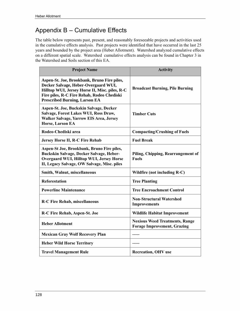
Heber Allotment
128
Appendix B – Cumulative Effects
The table below represents past, present, and reasonably foreseeable projects and activities used
in the cumulative effects analysis. Past projects were identified that have occurred in the last 25
years and bounded by the project area (Heber Allotment). Watershed analyzed cumulative effects
on a different spatial scale. Watershed cumulative effects analysis can be found in Chapter 3 in
the Watershed and Soils section of this EA.
Project Name Activity
Aspen-St. Joe, Brookbank, Bruno Fire piles,
Decker Salvage, Heber-Overgaard WUI,
Hilltop WUI, Jersey Horse II, Misc. piles, R-C
Fire piles, R-C Fire Rehab, Rodeo Chediski
Prescribed Burning, Larson EA
Broadcast Burning, Pile Burning
Aspen-St. Joe, Buckskin Salvage, Decker
Salvage, Forest Lakes WUI, Ross Draw,
Walker Salvage, Yarrow EIS Area, Jersey
Horse, Larson EA
Timber Cuts
Rodeo-Chediski area Compacting/Crushing of Fuels
Jersey Horse II, R-C Fire Rehab Fuel Break
Aspen-St Joe, Brookbank, Bruno Fire piles,
Buckskin Salvage, Decker Salvage, Heber-
Overgaard WUI, Hilltop WUI, Jersey Horse
II, Legacy Salvage, OW Salvage, Misc. piles
Piling, Chipping, Rearrangement of
Fuels
Smith, Walnut, miscellaneous Wildfire (not including R-C)
Reforestation Tree Planting
Powerline Maintenance Tree Encroachment Control
R-C Fire Rehab, miscellaneous Non-Structural Watershed
Improvements
R-C Fire Rehab, Aspen-St. Joe Wildlife Habitat Improvement
Heber Allotment Noxious Weed Treatments, Range
Forage Improvement, Grazing
Mexican Gray Wolf Recovery Plan -----
Heber Wild Horse Territory -----
Travel Management Rule Recreation, OHV use