hawaii statewide highways sustainable … · hawaii statewide highways sustainable landscape master...
TRANSCRIPT
Proceedings of the 2013 International Conference on Ecology and Transportation (ICOET 2013)
HAWAII STATEWIDE HIGHWAYS SUSTAINABLE LANDSCAPE MASTER PLAN
& ROADSIDE DESIGN GUIDE
Charlie Scott (206-624-5702, [email protected]) Senior Landscape Architect, Jones & Jones
Architects + Landscape Architects + Planners, 105 S. Main Street, Suite 300, Seattle, Washington 98104,
United States
ABSTRACT
Concurrent with ongoing initiatives to take a contextual or “Context Sensitive Solutions” (CSS) approach
to highway design and construction, there is an increasing emphasis on engaging a broad set of issues
related to environmental and social sustainability in developing and improving highways. The Hawaii
Statewide Highways Sustainable Landscape Master Plan and associated Roadside Design Guide represent
a concerted effort to make the state of Hawaii’s roadways and roadside landscapes more sustainable and
contextual. The Master Plan and Design Guide are an expression of traditional Hawaiian values of Pono
(resource protection and replenishment), Kuleana (shared responsibility), and Lokahi (human well-being).
The documents are intended to make highways, and those who plan and design them, more respectful of
the sensitive landscapes and local culture of the Islands.
The Master Plan and Design Guide—which augments extant literature on “sustainable best practices” in
the planning, construction, and maintenance of roads—fosters a systems-thinking and cultural landscape
approach to every highway improvement project. The Master Plan and Design Guide address how
roadways and roadsides affect the larger landscape, local ecosystems, and social setting. Basically, the
documents promote sustainable elements and treatments that will integrate streets, roads and highways
with their various settings while eliminating or lessening a roadway’s negative environmental effects.
Recommendations and guidelines are provided for a broad suite of issues and considerations including
water quality and resources, wildlife movement and habitat, vegetation, multi-modal travel, land use and
access, aesthetics, tourism and recreation, maintenance, and local economic activity.
Because each highway is in a different landscape setting with a different set of issues, the Master Plan
relies on a watershed spatial framework to subdivide the Hawaiian Islands into distinct cultural
landscapes for better comprehension of local contexts and natural ecosystems. This watershed framework
meshes with the ancient Hawaiians’ system of using large watersheds (Moku) and smaller watersheds
(Ahupua’a) for land management and political purposes. From this enhanced understanding of setting or
context, the plan redefines highways throughout the entire state according to their setting. Thus a two-lane
“rural arterial” is more accurately defined as a Sea-cliff Scenic Byway, Coastal Farmland Road, or
Shoreline Residential Drive, with important distinctions as to highway improvements and roadside
treatments for these different highway types.
The Master Plan and Design Guide integrate landscape-level, sustainable considerations and guidance
into the Hawaii Department of Transportation’s (HDOT) project design and delivery process by applying
sustainable recommendations to specific locations and conditions. Faced with limited resources, lengthy
permitting requirements, and multiple steps in project delivery, HDOT simply cannot implement a full-
blown CSS process for every project nor conduct the research on sustainable best practices for every
design decision and situation. With performance metrics, the Hawaii Statewide Highways Sustainable
Landscape Master Plan and Roadside Design Guide constitute a reliable source of sustainable and
contextual solutions to the dozens of highway projects that HDOT and its consultants undertake every
year. As such, the documents provide a practical framework for other DOT’s and highway planning
professionals who are pursuing sustainable and contextual approaches for developing and improving
highways.
Scott 2
INTRODUCTION
The Need for a Sustainable Master Plan
It can generally be said that driving a motor vehicle offers an enjoyable and rewarding experience despite
the occasional frustrations of traffic congestion, tedium, and mishaps. It is also an accepted truism that
our Hawaiian Islands qualify as one of the most beautiful and lovely places on earth. Driving the
Hawaiian Islands thus equals an unrivaled experience in exploration, discovery and enjoyment; millions
of visitors drive our islands yearly and many of their most memorable moments are from behind the
wheel. Local residents too never seem to tire of the spectacular land and sea vistas that unfold from the
road.
Hawaii’s highway system by and large meets locals’ and visitors’ transportation and mobility needs. Yet
all is not well in our fragile and isolated paradise. Our highway system has numerous deficiencies, and
many roads and highways threaten the environment and quality of life that both Hawaiians and visitors
hold dear. Highways and the traffic they carry pollute our air and water, damage streams and shorelines,
impede wildlife movement, divide neighborhoods, and spread noxious weeds. Some highways are over-
crowded or hazardous, while others don’t safely accommodate those who walk, bicycle, or use transit.
Moreover, we continue to invest increasing amounts of money and resources on highway design,
construction and maintenance without significantly improving local economies and fostering community
cohesion.
Hawaii’s highway system must adapt to meet the challenges of protecting our environment and
communities while serving the transportation needs of future generations. The Sustainable Landscape
Master Plan helps meet these challenges by addressing some of the environmental, social and economic
pressures confronting the state’s highway system. The plan enables the Hawaii Department of
Transportation (HDOT) to alleviate the problems of unsustainable highway development by integrating
landscape level, sustainable guidance and practices into HDOT’s highway design and project delivery
process.
Given all the information that currently exists on sustainable highway development and operation, it
might be asked why does Hawaii DOT need its own master plan and set of guidelines on sustainable
landscape practices. The simple answer is that sustainable practices must be tailored to fit particular
places and conditions in order for guidelines and practices to be effective. The wide range of
sustainability manuals and documents available from other sources provide good precedents, justification,
and parameters, but the indisputable value of a master plan is the direct, not hypothetical, identification of
sustainable practices for specific locations and conditions. This Master Plan and Roadside Design Guide
for Hawaii’s highways takes away much of the guesswork in evaluating and applying sustainable
practices, thereby simplifying the job of the HDOT and its consultants.
Because sustainability encompasses social, environmental, and economic dimensions – the so-called
triple bottom line of sustainability – many factors must be addressed in making roadside landscapes
sustainable. Roadsides consist of many things and perform many functions. The roadside can also be
viewed as the transition zone between the roadway and adjacent landscape. Sustainable best practices in
the master plan and associated design guide thus speak to issues of grading and drainage, storm water
treatment, vegetation, wildlife movement, noise buffering, visual screening, safety, travel mode, access,
aesthetics, maintenance, construction cost and many other issues for a variety of road types in different
settings.
Scott 3
PLAN GOALS & APPROACH
Systems-thinking is an underlying premise of sustainable policy and practice. Systems-thinking considers
how different elements interact with each other in the context of the larger whole. One application of
systems-thinking is how we look at nature where plants, animals, water, rocks, climate, etc. are all
interconnected and interdependent within a larger ecosystem. Systems-thinking holds that elements or
actions must be framed in terms of their relationship to other things and the larger system if the health and
well-being of the larger system and its constituent parts are to be maintained. This Sustainable Landscape
Master Plan incorporates a systems-thinking approach by looking at highways and highway components
in relationship to the larger landscape whole.
“Landscape” comprises everything of and on the land including streams, shorelines, historic buildings,
farms, neighborhoods, plants and animals. The term “cultural landscape” recognizes that people and their
actions have been shaped by and have shaped the natural landscape. Hawaii is teeming with cultural
landscapes where wonderful interplays of culture and nature are often apparent. Hawaii’s cultural
landscapes are wholly unique and are what make the state so compelling to visitors.
The over-arching goal of the Master Plan is to foster a systems-thinking approach and cultural landscape
perspective for every highway improvement project. Every action, or even inaction in some instances, has
potential environmental and social consequences within the context of the larger whole. Acknowledging
and addressing these consequences is at the root of making highways more sustainable and contextual.
The following goals and objectives describe what is to be generally accomplished by the Hawaii
Statewide Sustainable Landscape Master Plan:
1. Protect and Restore Natural Resources and Environmental Quality
Preserve and avoid damaging natural resources and ecosystems
Repair damaged landscapes – streams, wetlands, shorelines, hillsides, etc.
Maintain or re-establish wildlife habitat and travel corridors
Promote the use of native plants and control invasive plants
Reduce energy and resource consumption for highway construction, operation, and
maintenance
2. Provide a High Quality and Uniquely Hawaiian Experience for Highway Travelers
Improve highway safety and operation
Accommodate different travel modes including auto, bicycle, walking and transit
Access and highlight recreational places and resources
Protect and improve scenic quality
Provide information about local attractions, culture and history
Heighten one’s awareness about sense of place and Hawaii’s unique cultural landscapes
3. Support Local Communities and Economic Activity
Maintain and improve community quality of life
Support local businesses and economic activity: tourism, agriculture, retail commerce, etc.
Protect cultural and historical resources and reflect or highlight local cultural identity
Adapt the highway to the community setting and to support community dynamics
Involve local communities and neighborhoods in decisions about highway improvements
Scott 4
4. Foster an Integrated and Inclusive Highway Planning and Design Approach
Consider and address all issues in project planning and design
Promote coordination among state, federal and county agencies, community organizations,
environmental groups, and other interests
Encourage the creation of multi-disciplinary planning/design teams for projects
Integrate a sustainable and context sensitive methodology into the project delivery process.
SUSTAINABILITY & CONTEXT SENSITIVE SOLUTIONS
For the past twenty years, the Federal Highway Administration (FHWA) and most state DOT’s including
HDOT have promoted a context sensitive solutions (CSS) approach to the planning and design of
highways. CSS looks beyond a highway’s functional requirements and stipulates that the highway fit its
setting while preserving or improving natural, cultural and scenic resources and addressing or enhancing
community economies, multi-modal travel, and sound land-use practices. CSS also stipulates that
“context” be considered at the beginning of the project and that contextual issues have equal standing
with functional considerations. The CSS approach is essentially comprehensive and addresses all
substantive issues; CSS is not about highway decorations and embellishments. For example, the
implementation of wildlife crossing structures constitutes a legitimate CSS response to wildlife
movement across and along a highway whereas bas-relief silhouettes of animals and fish cast into
concrete bridge abutments and railings is not an effective CSS response to wildlife movement.
To a large extent, context sensitive outcomes are sustainable as well. If a project is planned and designed
through a CSS process to be “in harmony with the community and preserve environmental, scenic,
aesthetic, historic, and natural resource values” and to add “lasting value to the community and the
environment”, then the facility will embody sustainable practices. By the same token, sustainable
practices must be directly applicable or sensitive to the social and environmental context to be truly
sustainable.
Burdened with insufficient resources, lengthy permitting requirements, and multiple steps in project
delivery, HDOT and its consultants simply cannot take a full-blown CSS approach to every project.
However, HDOT does need a way to make every project more sustainable. The Master Plan provides this
capability by providing a set of place-based/corridor-specific sustainable recommendations and
guidelines. While the master plan should not be seen as a substitute to a CSS process, particularly for
larger projects, the plan can be used as a shortcut to finding contextual and sustainable solutions to the
dozens of highway improvement projects that HDOT undertakes every year.
LANDSCAPE FRAMEWORK & HIGHWAY CORRIDOR TYPE
The Master Plan’s sustainable best practices and recommendations hinge on the cultural landscape
context or setting for each highway. Therefore a method was needed for identifying and distinguishing
each island’s different cultural landscapes. A landscape framework of watersheds was used to partition
each island into a series of landscape districts for better understanding and discussion of the landscape
context. Historically the Hawaiian Islands were divided by the ancient Hawaiians into large watershed
districts (Moku) and smaller watershed units (Ahupua’a) for land management and political purposes, and
the Moku districting is still somewhat in use today for resource management and land planning. Within
this landscape framework of Moku watershed districts, various landscapes are seen to possess distinct
vegetarian types, terrain features, land use patterns, and other characteristics that can be used to
differentiate highway corridors from one another based on their setting.
Scott 5
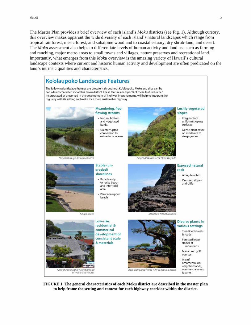
The Master Plan provides a brief overview of each island’s Moku districts (see Fig. 1). Although cursory,
this overview makes apparent the wide diversity of each island’s natural landscapes which range from
tropical rainforest, mesic forest, and subalpine woodland to coastal estuary, dry shrub-land, and desert.
The Moku assessment also helps to differentiate levels of human activity and land use such as farming
and ranching, major metro areas to small towns and villages, nature preserves and recreational land.
Importantly, what emerges from this Moku overview is the amazing variety of Hawaii’s cultural
landscape contexts where current and historic human activity and development are often predicated on the
land’s intrinsic qualities and characteristics.
FIGURE 1 The general characteristics of each Moku district are described in the master plan
to help frame the setting and context for each highway corridor within the district.
Scott 6
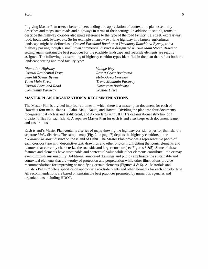
In giving Master Plan users a better understanding and appreciation of context, the plan essentially
describes and maps state roads and highways in terms of their settings. In addition to setting, terms to
describe the highway corridor also make reference to the type of the road facility; i.e. street, expressway,
road, boulevard, byway, etc. So for example a narrow two-lane highway in a largely agricultural
landscape might be defined as a Coastal Farmland Road or an Upcountry Ranchland Byway, and a
highway passing though a small town commercial district is designated a Town Main Street. Based on
setting again, sustainable best practices for the roadside landscape and roadside elements are readily
assigned. The following is a sampling of highway corridor types identified in the plan that reflect both the
landscape setting and road facility type:
Plantation Highway Village Way
Coastal Residential Drive Resort Coast Boulevard
Sea-cliff Scenic Byway Metro-Area Freeway
Town Main Street Trans-Mountain Parkway
Coastal Farmland Road Downtown Boulevard
Community Parkway Seaside Drive
MASTER PLAN ORGANIZATION & RECOMMENDATIONS
The Master Plan is divided into four volumes in which there is a master plan document for each of
Hawaii’s four main islands – Oahu, Maui, Kauai, and Hawaii. Dividing the plan into four documents
recognizes that each island is different, and it correlates with HDOT’s organizational structure of a
division office for each island. A separate Master Plan for each island also keeps each document leaner
and easier to use.
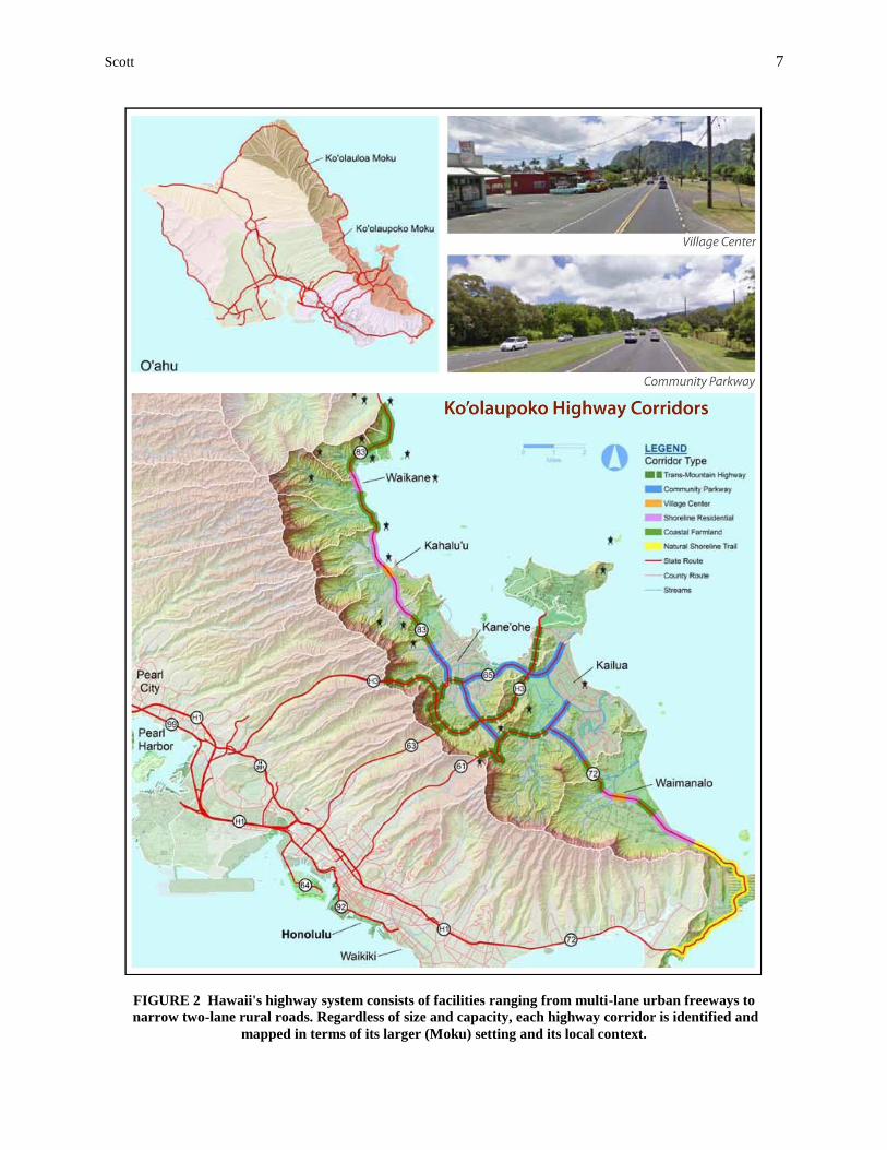
Each island’s Master Plan contains a series of maps showing the highway corridor types for that island’s
separate Moku districts. The sample map (Fig. 2 on page 7) depicts the highway corridors in the
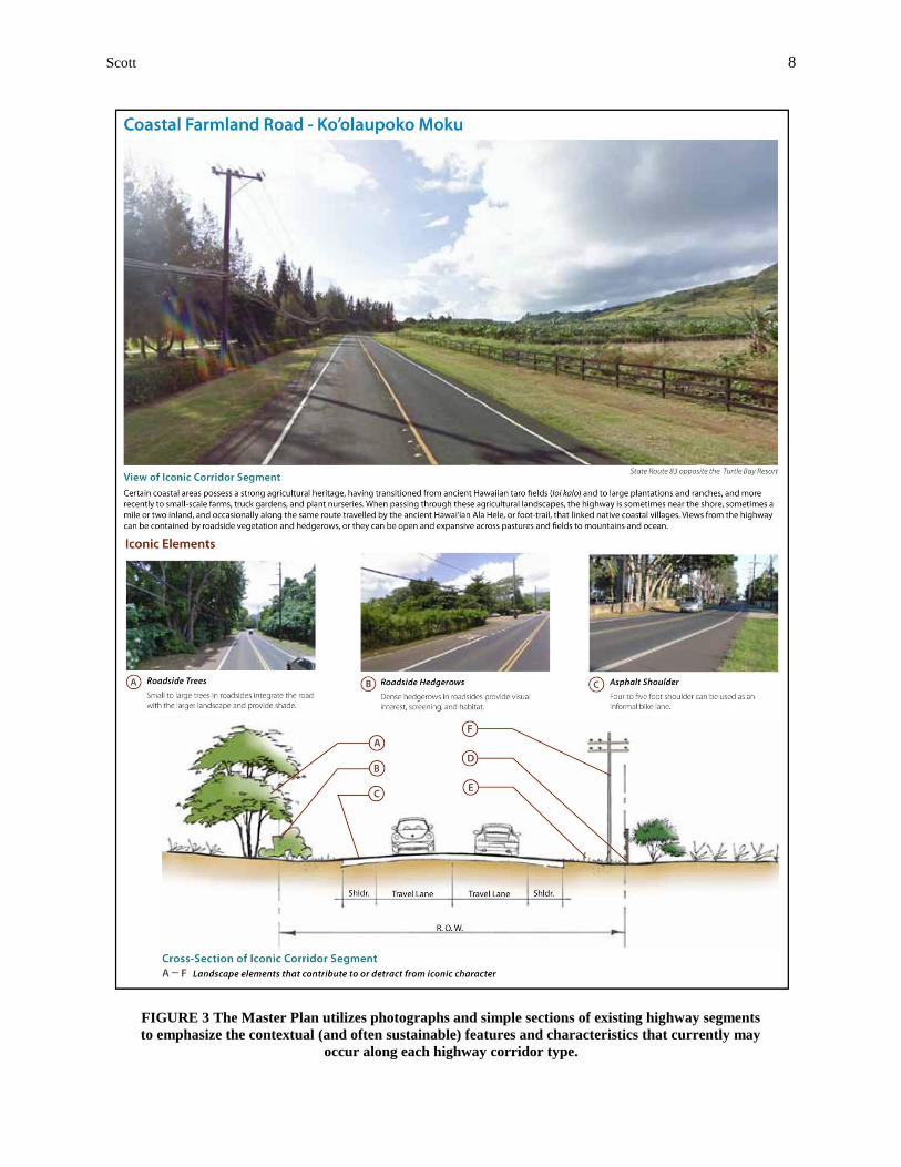
Ko’olaupoko Moku district on the island of Oahu. The Master Plan provides a representative photo of
each corridor type with descriptive text, drawings and other photos highlighting the iconic elements and
features that currently characterize the roadside and larger corridor (see Figures 3 &5). Some of these
features and elements have sustainable and contextual value while other elements contribute little or may
even diminish sustainability. Additional annotated drawings and photos emphasize the sustainable and
contextual elements that are worthy of protection and perpetuation while other illustrations provide
recommendations for improving or modifying certain elements (Figures 4 & 6). A “Materials and
Finishes Palette” offers specifics on appropriate roadside plants and other elements for each corridor type.
All recommendations are based on sustainable best practices promoted by numerous agencies and
organizations including HDOT.
Scott 7
FIGURE 2 Hawaii's highway system consists of facilities ranging from multi-lane urban freeways to
narrow two-lane rural roads. Regardless of size and capacity, each highway corridor is identified and
mapped in terms of its larger (Moku) setting and its local context.
Scott 8
FIGURE 3 The Master Plan utilizes photographs and simple sections of existing highway segments
to emphasize the contextual (and often sustainable) features and characteristics that currently may
occur along each highway corridor type.
Scott 9
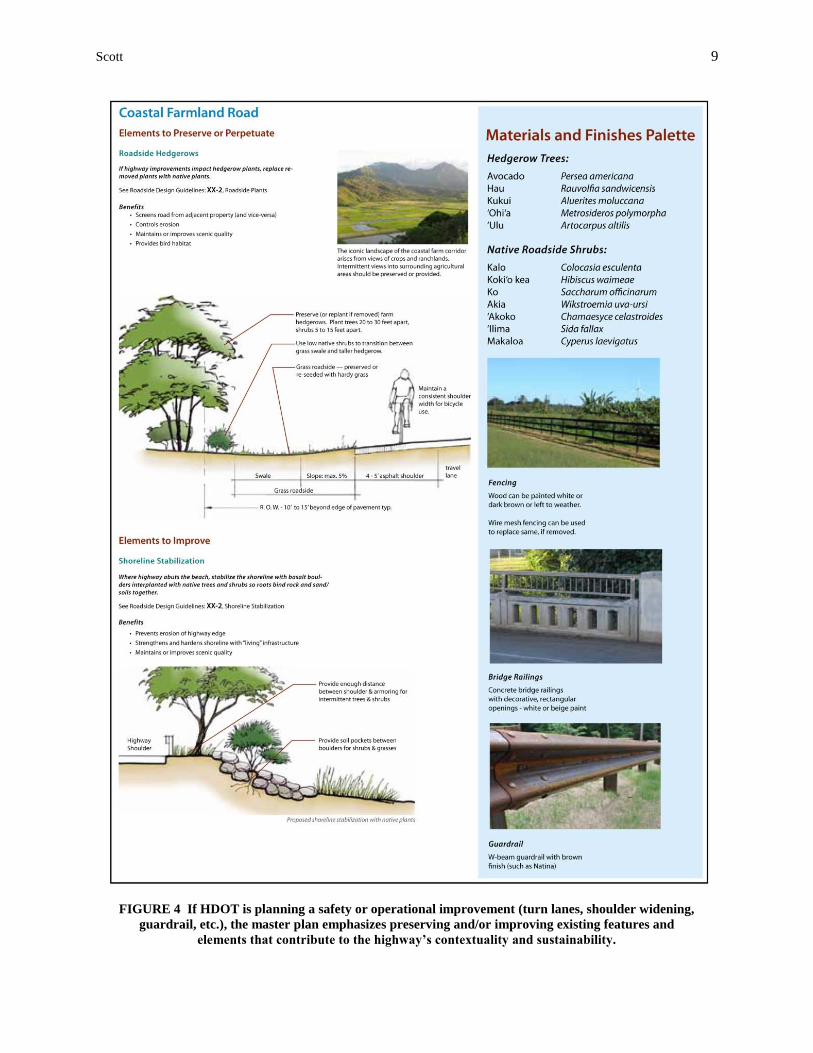
FIGURE 4 If HDOT is planning a safety or operational improvement (turn lanes, shoulder widening,
guardrail, etc.), the master plan emphasizes preserving and/or improving existing features and
elements that contribute to the highway’s contextuality and sustainability.
Scott 10
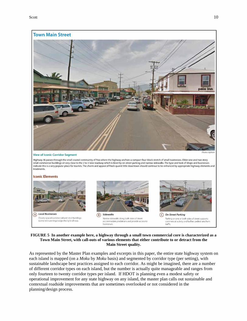
FIGURE 5 In another example here, a highway through a small town commercial core is characterized as a
Town Main Street, with call-outs of various elements that either contribute to or detract from the
Main Street quality.
As represented by the Master Plan examples and excerpts in this paper, the entire state highway system on
each island is mapped (on a Moku by Moku basis) and segmented by corridor type (per setting), with
sustainable landscape best practices assigned to each corridor. As might be imagined, there are a number
of different corridor types on each island, but the number is actually quite manageable and ranges from
only fourteen to twenty corridor types per island. If HDOT is planning even a modest safety or
operational improvement for any state highway on any island, the master plan calls out sustainable and
contextual roadside improvements that are sometimes overlooked or not considered in the
planning/design process.
Scott 11
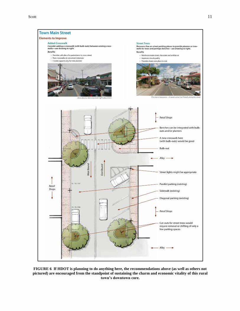
FIGURE 6 If HDOT is planning to do anything here, the recommendations above (as well as others not
pictured) are encouraged from the standpoint of sustaining the charm and economic vitality of this rural
town’s downtown core.
Scott 12
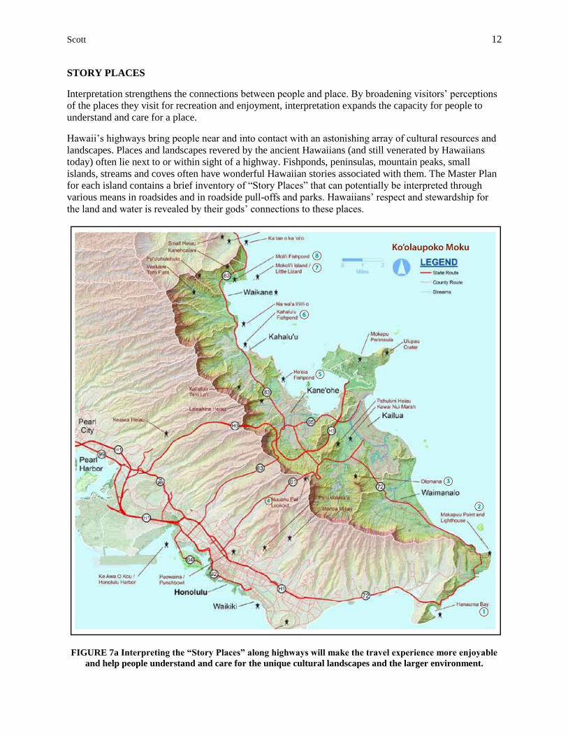
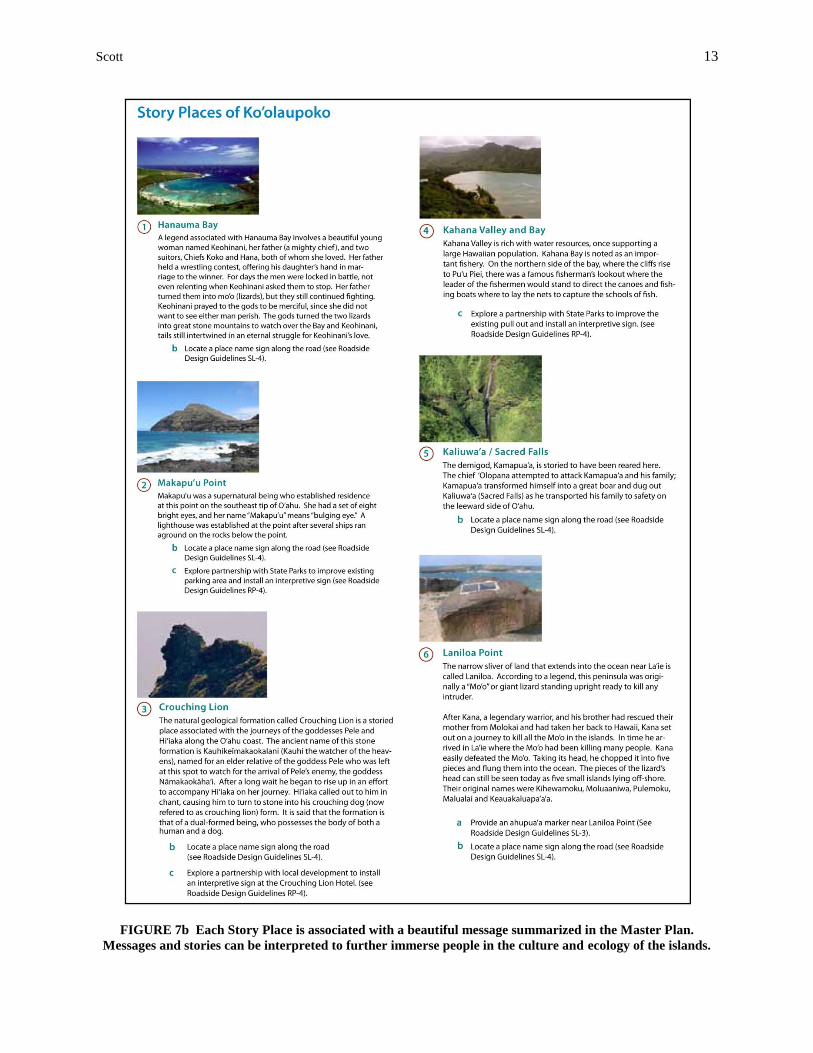
STORY PLACES
Interpretation strengthens the connections between people and place. By broadening visitors’ perceptions
of the places they visit for recreation and enjoyment, interpretation expands the capacity for people to
understand and care for a place.
Hawaii’s highways bring people near and into contact with an astonishing array of cultural resources and
landscapes. Places and landscapes revered by the ancient Hawaiians (and still venerated by Hawaiians
today) often lie next to or within sight of a highway. Fishponds, peninsulas, mountain peaks, small
islands, streams and coves often have wonderful Hawaiian stories associated with them. The Master Plan
for each island contains a brief inventory of “Story Places” that can potentially be interpreted through
various means in roadsides and in roadside pull-offs and parks. Hawaiians’ respect and stewardship for
the land and water is revealed by their gods’ connections to these places.
FIGURE 7a Interpreting the “Story Places” along highways will make the travel experience more enjoyable
and help people understand and care for the unique cultural landscapes and the larger environment.
Scott 13
FIGURE 7b Each Story Place is associated with a beautiful message summarized in the Master Plan.
Messages and stories can be interpreted to further immerse people in the culture and ecology of the islands.
Scott 14
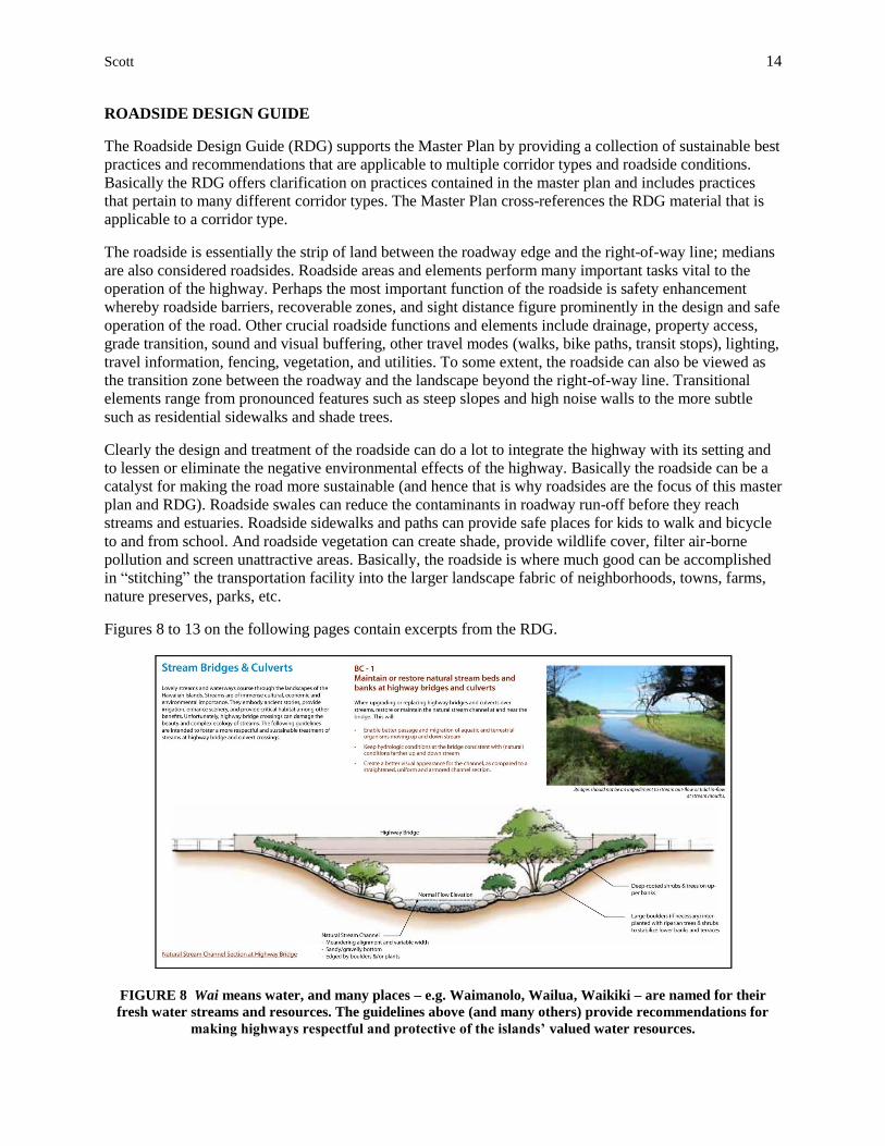
ROADSIDE DESIGN GUIDE
The Roadside Design Guide (RDG) supports the Master Plan by providing a collection of sustainable best
practices and recommendations that are applicable to multiple corridor types and roadside conditions.
Basically the RDG offers clarification on practices contained in the master plan and includes practices
that pertain to many different corridor types. The Master Plan cross-references the RDG material that is
applicable to a corridor type.
The roadside is essentially the strip of land between the roadway edge and the right-of-way line; medians
are also considered roadsides. Roadside areas and elements perform many important tasks vital to the
operation of the highway. Perhaps the most important function of the roadside is safety enhancement
whereby roadside barriers, recoverable zones, and sight distance figure prominently in the design and safe
operation of the road. Other crucial roadside functions and elements include drainage, property access,
grade transition, sound and visual buffering, other travel modes (walks, bike paths, transit stops), lighting,
travel information, fencing, vegetation, and utilities. To some extent, the roadside can also be viewed as
the transition zone between the roadway and the landscape beyond the right-of-way line. Transitional
elements range from pronounced features such as steep slopes and high noise walls to the more subtle
such as residential sidewalks and shade trees.
Clearly the design and treatment of the roadside can do a lot to integrate the highway with its setting and
to lessen or eliminate the negative environmental effects of the highway. Basically the roadside can be a
catalyst for making the road more sustainable (and hence that is why roadsides are the focus of this master
plan and RDG). Roadside swales can reduce the contaminants in roadway run-off before they reach
streams and estuaries. Roadside sidewalks and paths can provide safe places for kids to walk and bicycle
to and from school. And roadside vegetation can create shade, provide wildlife cover, filter air-borne
pollution and screen unattractive areas. Basically, the roadside is where much good can be accomplished
in “stitching” the transportation facility into the larger landscape fabric of neighborhoods, towns, farms,
nature preserves, parks, etc.
Figures 8 to 13 on the following pages contain excerpts from the RDG.
FIGURE 8 Wai means water, and many places – e.g. Waimanolo, Wailua, Waikiki – are named for their
fresh water streams and resources. The guidelines above (and many others) provide recommendations for
making highways respectful and protective of the islands’ valued water resources.
Scott 15
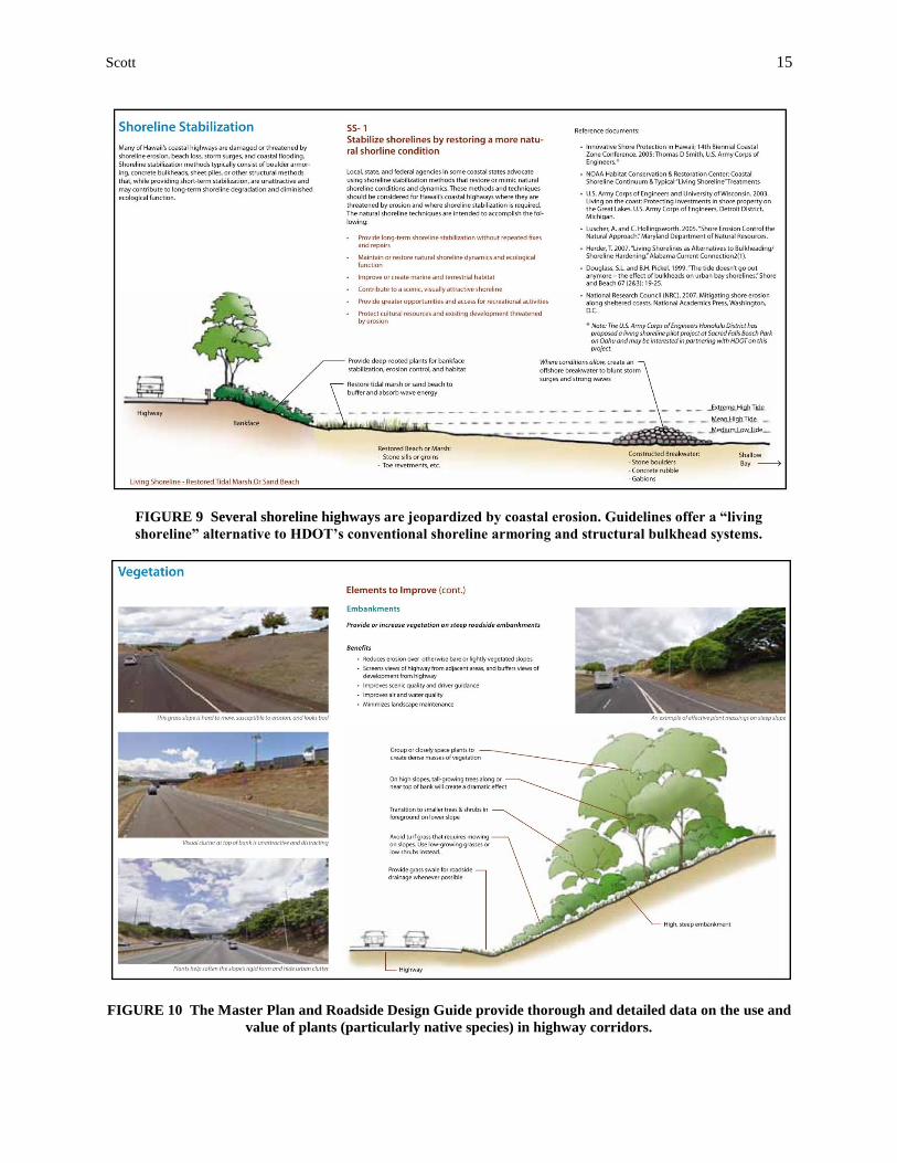
FIGURE 9 Several shoreline highways are jeopardized by coastal erosion. Guidelines offer a “living
shoreline” alternative to HDOT’s conventional shoreline armoring and structural bulkhead systems.
FIGURE 10 The Master Plan and Roadside Design Guide provide thorough and detailed data on the use and
value of plants (particularly native species) in highway corridors.
Scott 16
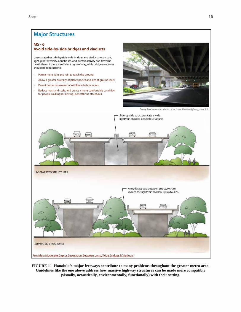
FIGURE 11 Honolulu’s major freeways contribute to many problems throughout the greater metro area.
Guidelines like the one above address how massive highway structures can be made more compatible
(visually, acoustically, environmentally, functionally) with their setting.
Scott 17
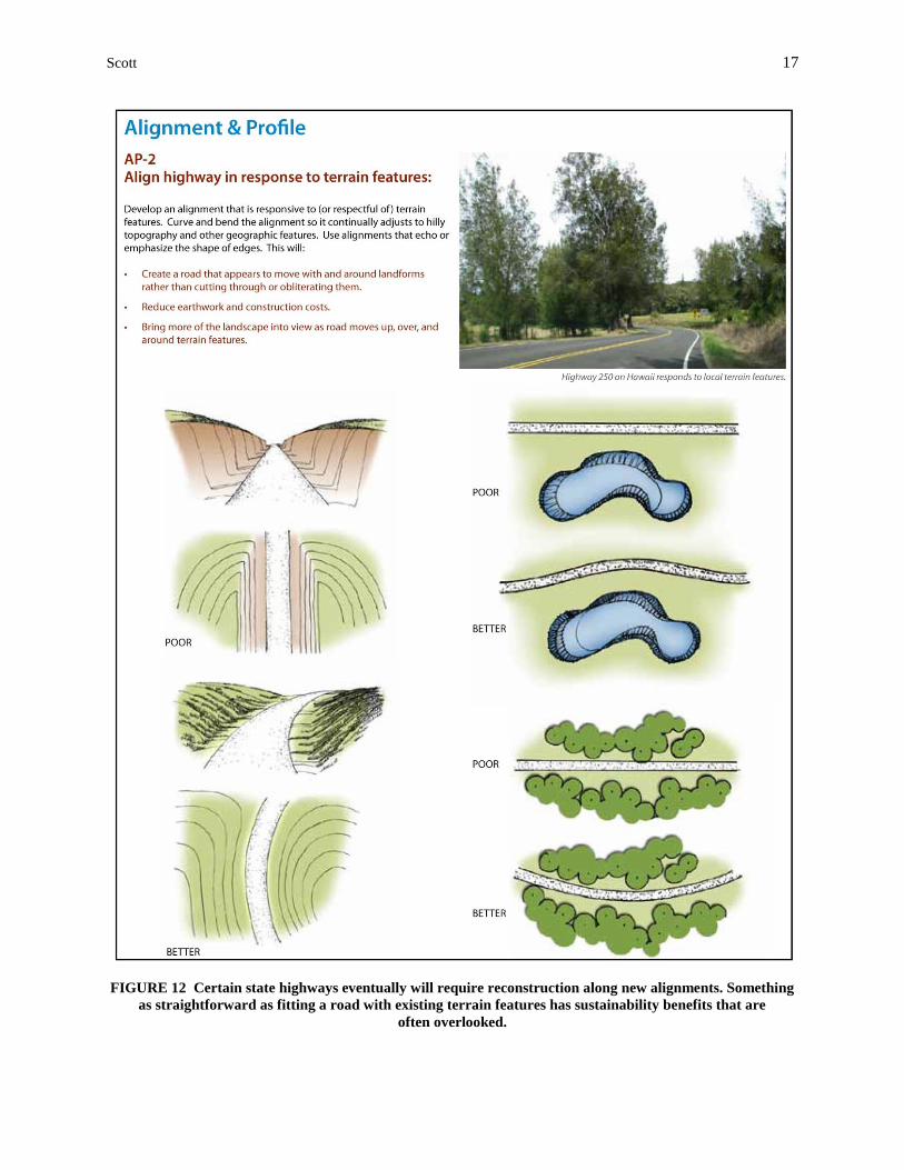
FIGURE 12 Certain state highways eventually will require reconstruction along new alignments. Something
as straightforward as fitting a road with existing terrain features has sustainability benefits that are
often overlooked.
Scott 18
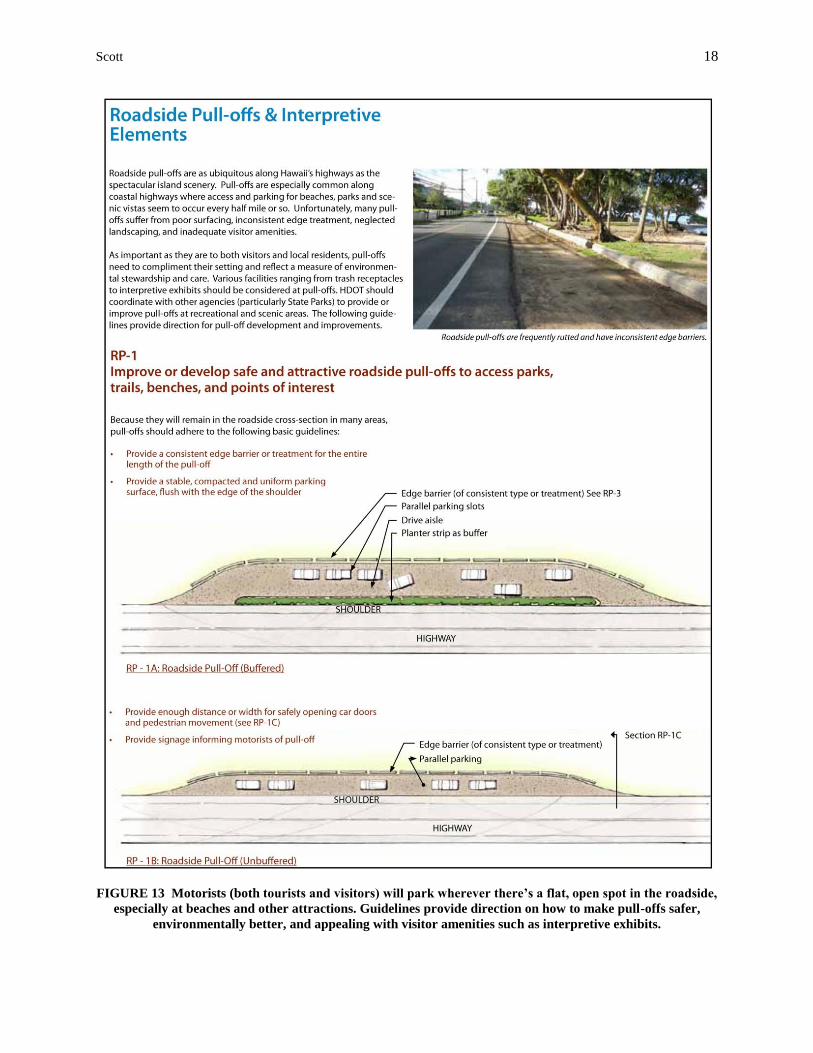
FIGURE 13 Motorists (both tourists and visitors) will park wherever there’s a flat, open spot in the roadside,
especially at beaches and other attractions. Guidelines provide direction on how to make pull-offs safer,
environmentally better, and appealing with visitor amenities such as interpretive exhibits.
Scott 19
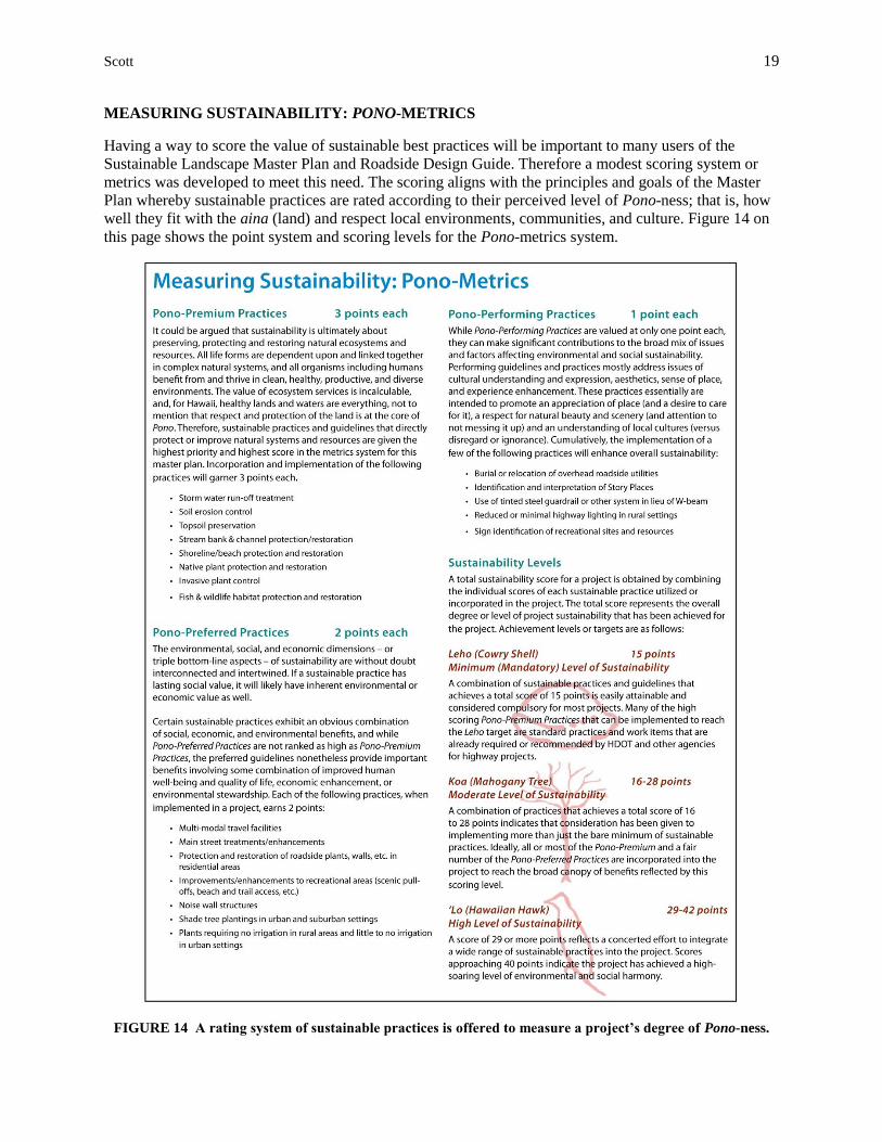
MEASURING SUSTAINABILITY: PONO-METRICS
Having a way to score the value of sustainable best practices will be important to many users of the
Sustainable Landscape Master Plan and Roadside Design Guide. Therefore a modest scoring system or
metrics was developed to meet this need. The scoring aligns with the principles and goals of the Master
Plan whereby sustainable practices are rated according to their perceived level of Pono-ness; that is, how
well they fit with the aina (land) and respect local environments, communities, and culture. Figure 14 on
this page shows the point system and scoring levels for the Pono-metrics system.
FIGURE 14 A rating system of sustainable practices is offered to measure a project’s degree of Pono-ness.
Scott 20
USING THE MASTER PLAN: HOW, WHEN, WHY & WHO
Each year HDOT carries out dozens of highway projects of different types and scales, at various
locations, and in various stages of development. The Master Plan and associated Roadside Design Guide
are to be referenced and used for all types of highway projects – large and small – in any location, and
throughout HDOT’s project delivery process from initial planning to construction. The material is
illustrative and succinct and intended primarily for highway engineers, but it can also be of value for other
planning and design professions, state and local officials, community groups, environmental
organizations and basically anyone with an interest or stake in highway projects. Based on a project’s
location, a Master Plan user simply refers to plan maps to determine the highway corridor type for which
sustainable best practices and recommendations are then provided.
The Master Plan draws upon current, state-of-the-art empirical data on sustainability policy, planning, and
practices without rehashing tedious proofs, examples, and performance metrics. Not to be simply taken at
its word, the plan references other state and local initiatives and manuals that promote sustainability with
regard to issues of storm-water treatment, multi-modal (ped, bike, transit) travel, invasive plant control,
shoreline stabilization, wildlife protection, pesticide use, stream and wetland restoration and preservation,
and energy consumption. Users of the Master Plan will thus find consistency and corroboration among a
whole host of local and national documents on sustainability programs and practices.
Although the Master Plan and Roadside Design Guide are “how-to” manuals covering a number of
highway design issues and topics, the documents are not technical design manuals in the strict sense of
the term. The Master Plan and Design Guide provide little in the way of hard design criteria such as sizes,
distances, and rates, nor are methods provided for determining this data. (The reason for this limitation is
two-fold: first, it was beyond the scope of the project to develop this data, and second this data and
criteria can be found in other manuals on sustainability design and best practices.) The primary purpose of
the Master Plan and Design Guide is to give users a collection of empirically validated sustainable options
to the design and treatment of roadsides and roadside elements. The documents are intended to be
informative and instructive, but not didactic or absolute – there are no “standards” or compulsory
techniques and outcomes presented here. The Master Plan and Design Guide are simply a way of showing
people how to go about making highways more contextual and sustainable, and why this is important.
CONCLUSION
For those of us who visit Hawaii for vacations and holidays, we can often find ourselves in places that
have many of the trappings of the mainland but with a dramatically different landscape backdrop in a
great climate. If we expect all the creature-comforts of home, including roads and highways to every
remote corner, the people of Hawaii may be happy to accommodate us in an economy based on tourism
and tourist satisfaction. If on the other hand we place more value on the Islands’ clean waters, unique
native flora, unscarred mountainsides, quaint towns, and lovely beaches, then we have to let the locals
know we appreciate what they value too. The State of Hawaii will be improving and building roads and
highways long into the future, and roads will continue to have major implications for the Island’s social
and environmental well being. Visitors and locals alike must advocate for not only safe roads but for
healthy and sustainable roads if Hawaii is to remain the island paradise we all cherish.
AUTHOR BIO
Charlie Scott is a registered Landscape Architect with Jones & Jones Architects and Landscape Architects in
Seattle, WA. Charlie has over twenty five years of experience in the planning and design of transportation
facilities that require careful integration into sensitive landscapes. Award-winning projects include the design
of the Paris-Lexington Road (Paris Pike) in Kentucky, recognized as a benchmark CSS project, and the design
for the reconstruction of U.S. Highway 93 in western Montana, celebrated as “America’s Wildlife Highway”.