handbook - wake forest, nc forest unified development ordinance handbook | 7 chapter 1 introduction...
TRANSCRIPT

H A N D B O O K
Unified Development Ordinance
A Concise Guide to the Wake Forest UDO


Wake Forest Unified Development Ordinance
Handbook
September 2014
Wake Forest Town Hall301 S. Brooks StreetWake Forest, NC 27587919-435-9400www.wakeforestnc.gov
Planning Department: Third Floor, Wake Forest Town Hall919-435-9510www.wakeforestnc.gov/planning.aspx
Published by the Wake Forest Planning DepartmentSeptember 2014

Contents
C H A P T E R 1 Introduction . . . . . . . . . . . . . . . . . . . . . . . . . . . . . . . . . . . . . . . . . . . . . 7
C H A P T E R 2 Frequently Asked Questions . . . . . . . . . . . . . . . . . . . . . . . . . . . 8
C H A P T E R 3 UDO Chapter Summaries . . . . . . . . . . . . . . . . . . . . . . . . . . . . . 10
C H A P T E R 4 Zoning Districts . . . . . . . . . . . . . . . . . . . . . . . . . . . . . . . . . . . . . . 14
C H A P T E R 5 Rezonings . . . . . . . . . . . . . . . . . . . . . . . . . . . . . . . . . . . . . . . . . . . . . . 21
C H A P T E R 6 Special Use Permits . . . . . . . . . . . . . . . . . . . . . . . . . . . . . . . . . . 23
C H A P T E R 7 Major Plan Review . . . . . . . . . . . . . . . . . . . . . . . . . . . . . . . . . . . 25
C H A P T E R 8 Major Architectural Design Review . . . . . . . . . . . . . . 26
C H A P T E R 9 Variances and Administrative Modi�cations of Setbacks . . . . . . . . . . . . . . . . . . . . . . . . . . 27
C H A P T E R 10 Certi�cate of Appropriateness . . . . . . . . . . . . . . . . . . . . . 29
A P P E N D I C E S
A UDO Administrative Agencies . . . . . . . . . . . . . . . . . . . . 30
B Land Use Table . . . . . . . . . . . . . . . . . . . . . . . . . . . . . . . . . . . . . . . . 33
C Development Review Process Flow Chart . . . . . . . . . . . . . . . . . . . . . . . . . . . . . . . . . . . . . . . . . . . . . 38
D Glossary of Commonly Used Planning Terms . . . . . . . . . . . . . . . . . . . . . . . . . . . . . . . . . . . . . . . 40


Wake Forest Unified Development Ordinance Handbook | 7
CHAPTER 1
Introduction
North Carolina General Statue 160A-381 permits local governments the ability to adopt zoning and development ordinances for the purpose of promoting the health, safety, morals and the general welfare of their community. These regulations can be adopted as separate ordinances or as one document commonly referred to as a unified development ordinance (UDO).
In 2010, The Lawrence Group, a nationally recognized and award winning town planning and design firm, was hired by the town to prepare a comprehensive anal-ysis of all development related codes and ordinances. The recommendations of this report along with specific action items set forth in the Wake Forest Community Plan led the town to begin the process of integrating all related development or-dinances into a single document, which would become the Wake Forest Unified Development Ordinance.
After nearly three years of preparation by town staff, The Lawrence Group and the UDO Advisory Committee, the town’s Unified Development Ordinance was presented to the Wake Forest Board of Commissioners in April of 2013 and official-ly adopted on July 16, 2013.
The UDO is a partial re-write, reorganization and consolidation of previously adopted land development ordinances (Zoning, Subdivision, Erosion and Sedimen-tation Control, Phase 2 Storm Water and the Manual of Specifications, Standards & Design) into a single document. It also serves as an implementation tool for many of the visions statements, policies and action items set forth in the Wake Forest Community Plan.
One of the most important goals in developing the UDO was to create a cohesive document that is easy to navigate and written in a user-friendly manner. While these goals were achieved, the document still serves as a highly-technical device main-ly used by planners, engineers, architects and surveyors for development related purposes. This handbook serves as a tool for citizens, businesses, developers, civic leaders or town employees who want to have a better understanding of the town’s zoning, land use and development requirements. Annotated diagrams, graphs and charts have been added to help with visualizing and understanding some of these regulations.
This handbook is not a legal document and while it may serve as a significant tool for all users, it should be used as a guide and not a substitute for the actual Unified Development Ordinance which is available online at www.wakeforestnc.gov/planning.aspx.

8 | C H A P T E R 2
CHAPTER 2
Frequently Asked Questions
What is the Uni�ed Development Ordinance (UDO)? The UDO is a consol-idated document which contains all of the town’s regulations for zoning, develop-ment, subdivisions, flood damage prevention, erosion and sedimentation control, and storm water.
What is the relationship between the Wake Forest Community Plan and the UDO? The Community Plan serves as a comprehensive, long-range guide that establishes development related vision statements and policies. The UDO serves as an implementation tool for many of the development related visions statements, policies and action items set forth in the community plan.
What land area does the UDO regulate? All provisions of the UDO apply to land within the corporate limits and extra-territorial jurisdiction (ETJ) as identified on the official zoning map of the Town of Wake Forest. This map can be viewed at www.wakeforestnc.gov/maps-plans-ordinances.aspx.
Why did the town develop a UDO and what happened to the old codes?Many of the original land use ordinances needed updating and with the adoption of the Community Plan, some of these standards were in conflict with its recommen-dations. A cohesive document was needed to replace the older land development ordinances; therefore, the UDO was developed to consolidate development regula-tions and other related ordinances into a single ordinance.
Who can I contact for questions about the UDO? The Wake Forest Planning Department is responsible for administering most of the UDO as it relates to zon-ing and development. Please call 919-435-9510 or visit the planning department’s home page at www.wakeforestnc.gov/planning.aspx for staff contact information.
What activities require a development permit per the UDO? Since development permits indicate compliance with the provisions of the UDO, all construction or development of any new use as well as any other site improvement as indicated in the UDO requires a development permit. In addition to new uses, a development permit is required for expansions of existing uses, changes of use, any uses permitted with special conditions and any signage requiring a permit. Typical development permits are issued for signs, fences, accessory buildings and home occupations.

Wake Forest Unified Development Ordinance Handbook | 9
How can I �nd application and plan review fees associated with the UDO? All town fees can be viewed on the comprehensive list of fees and charges. This can be viewed at www.wakeforestnc.gov/fees-charges-1.aspx.
Where can I view a copy of the entire UDO? The entire UDO and official zoning map can be viewed and downloaded via the town’s website at www.wake-forestnc.gov/maps-plans-ordinances.aspx.
What role does the Wake Forest Planning Board have in the development process? The Planning Board provides recommendations to the Wake Forest Board of Commissioners on applications related to zoning, special use permits and major site/subdivision master plans.
To seek formal input regarding these issues, the Planning Board and Board of Commissioners hold “joint” public hearings on the first Tuesday of the month. The Planning Board meets after the joint public hearing and votes to recommend ap-proval or denial of the application. Their recommendation is then forwarded to the Board of Commissioners.
How can I �nd out what my property is zoned? The official zoning map can be viewed at www.wakeforestnc.gov/fees-charges-1.aspx or contact the planning department at 919-435-9510.
How can I �nd out what land uses are allowed in a particular zoning dis-trict? Chapter 2 of the UDO provides a table listing land uses and the correspond-ing zoning district that indicate if the use is not permitted, permitted, permitted with standards or permitted with a special use permit. This table can be viewed on page 38 of this document.
What happened to my old zoning designation once the UDO was adopted? Most of the zoning districts that were in place prior to July 2013 were eliminated or replaced. For the majority of the parcels, the effect of the new zoning districts was very minimal and every effort was made to apply a new zoning district designation that closely resembled the old designation or actual land use of the parcel. If zoning conditions or a special use permit were in place prior to the adoption of the UDO, those conditions/permits did not change.

10 | C H A P T E R 3
CHAPTER 3
UDO Chapter Summaries
CH. 1 Purpose & Applicability This chapter outlines the basic authority and jurisdiction of the Unified Development Ordinance. It also provides the general purposes and intent of the ordinance with respect to the Wake Forest Community Plan and all other adopted plans and policies of the town.
CH. 2 District Provisions The town’s official zoning districts are de-scribed in this chapter along with development standards (minimum lot sizes, setbacks, etc.) and permitted uses. A use table is provided for readers to easily determine if a use type is allowed in a particular zoning district.
CH. 3 Supplemental Use Standards In certain zoning districts, land uses are per-mitted provided they meet conditions specified to their design and/or operation. The land uses listed in this chapter are permitted with additional stan-dards by staff or a special use permit by the Board of Commissioners. Each land use has standards to ensure compatibility so that different uses may be located in proximity to one another without ad-verse effects to either.
CH. 4 General Provisions Regulations in this chapter apply to all devel-opments regardless of the underlying zoning dis-trict provisions. Basic lot and use standards for street frontages, encroachments, building height and accessory uses/structures are established in this chapter along with specific requirements for temporary uses (seasonal sales, construction trail-ers, festivals, etc.).

Wake Forest Unified Development Ordinance Handbook | 11
CH. 5 Building Design StandardsThis chapter establishes architectural standards
and design requirements to ensure that the physical characteristic of a proposed development is com-patible with the context of the surrounding area and preserves certain characteristics unique to Wake Forest. Details for site design and building materi-als are assigned by building type (civic/institutional, residential, commercial, and industrial).
CH. 6 Subdivision & Infrastructure StandardsChapter 6 establishes criteria for site develop-
ment and subdivision of real property. Provisions for improvements such as adequate streets, util-ities, transportation and pedestrian facilities are provided. This chapter also coordinates proposed developments with existing development and with officially adopted plans for future development.
CH. 7 Recreation Facility Fees, Parks & Open Space Land
The intent of this chapter is to require that each new development contribute to a range of parks and open space critical to the quality of life for each resident within a particular development. Specific requirements for location, size, and type of neighborhood park and open space areas (both improved and natural) are given.
CH. 8 Tree Protection, Buffers & LandscapingThe Town seeks to maintain an overall coverage
of mature trees and existing landscaping through-out the entire community. In order to meet this goal, standards for tree canopy coverage, tree preservation and protection, street trees and buf-fer requirements are provided in Chapter 8. The requirements in this chapter assist with maintain-ing the positive community image associated with the Town’s mature vegetation and helps mitigate the negative impacts of noise, glare, air and water pollution, and soil erosion on the environment of the Town and its inhabitants.

12 | C H A P T E R 3
CH. 9 Parking and Driveways Parking lots and similar facilities are necessary elements in the urban environment. However, the provision of parking facilities are regulated in or-der to avoid negative impacts such as increased storm water volume, surface pollutants and levels of heart and glare. The purpose of this chapter is to ensure the adequate provision of parking spaces/ facilities in Wake Forest without degrading the ur-ban and natural environment.
CH. 10 Lighting The standards in this chapter are designed to focus on the actual physical effects of lighting as well as the effect that lighting may have on sur-rounding neighborhoods. It is the intent of this chapter to guide the design of developments to:
n Minimizing light pollution such as glare and light trespass;
n Conserve energy and recourses;n Maintain nighttime safety;n Improve the nighttime visual environment.
CH. 11 Signs All signs within the Town’s jurisdiction are covered by the regulations found in this chapter. Regulations are established to ensure that signs are compatible (size, type, location) with their surroundings, do not become a public hazard, preserve the characteristics of each district and to protect and enhance the overall appearance of the community.
CH. 12 Erosion, Flood, Stormwater & Watershed Standards This chapter is divided into four sections:
n Erosion and Sedimentation Control;n Flood Damage Prevention;n Stormwater Management;n Watershed Protection.
Wake Forest Unified Development Ordinance Handbook | 13
The regulations listed in Chapter 12 control land disturbance activities associ-ated with development. Also included in this chapter are the restrictions for activ-ities in Special Flood Hazard Areas and water quality protections measures for the Town’s watersheds (Smith Creek, Richland Creek and Falls Lake).
CH. 13 NonconformitiesNonconformities can be land uses, plans, lots
or structures that were legally established prior to the effective date of the UDO that do not conform to the most current regulations. This chapter reg-ulates and limits the continued existence of such land uses, plans, lots and structures and provides specific standards for each.
CH. 14 Administrative AgenciesThe various provisions of the UDO is administered under the general direction
of the town manager and the specific direction of various town departments. The powers and duties (as it relates to this ordinance) of each department, advisory board and decision making board is described in this chapter.
CH. 15 AdministrationIn order to establish an orderly process to develop land within the Town’s juris-
diction consistent with standard development practices and terminology, the pur-pose of this chapter is to provide a clear and comprehensible development process that is fair and equitable to all interests including the petitioners, affected neigh-bors, town staff, advisory boards and the Board of Commissioners.
CH. 16 Violations and PenaltiesWhenever a violation of the UDO occurs, any person may file a written com-
plaint describing the alleged violation. These complaints are investigated by town staff and if found to be valid, trigger the Town to take appropriate actions to correct the violation. This chapter describes the process for issuing violation notices, civil penalties and orders of abatement to remove violations such as prohibited signage, illegal land disturbance activities, and other development related activities.
CH. 17 DefinitionsFor the purpose of interpreting the UDO, certain words, concepts and ideas are
defined in this chapter.

14 | C H A P T E R 4
CHAPTER 4
Zoning Districts
Zoning creates a number of different districts or “zones,” each of which sets spe-cific rules on how the land in that district can be used. For example, a district set aside for residential land uses may exclude businesses and industries. The specific rules and zoning boundaries are set forth in the Town’s official zoning map which is part of the Unified Development Ordinance and which can be viewed on the town’s website at www.wakeforestnc.gov/maps-plans-ordinances.aspx. In addition to specifying land uses permitted in each zone, the UDO also sets detailed standards on how uses may be carried out (i.e. setbacks from a street right-of-way, minimum lot size, etc.). Wake Forest has two main categories for all zoning districts: Urban Districts and Rural/Suburban Districts.
URBAN (FORM-BASED) DISTRICTS A number of the key districts for the Town are ordered and classified according to the Rural-Urban Transect. The transect is a method of classifying the natural and built environments as a con-tinuum of six conditions, ranging from rural to urban. The value of the transect is that it classifies development form with the ap-propriate land use and development context. For example, a rural street typically has no curbs or sidewalks and its buildings are often irregularly spaced. An urban street, depending on the intensity of urbanism, may have curbs and gutters, regularly placed street trees, sidewalks, and building forms that are more regular in form and spacing. Each urban zoning category has detailed provisions for the mix of uses, building type, density, height, street design, the design of parks and open space, the mix of uses, building design, parking, streetscape and other aspects of the human environment.
Urban District Descriptions
Urban Residential (UR) The Urban Residential District is established as a predominately residential district in which a variety of types of housing is permitted, including single-family and duplex residences, small apartment buildings and townhouses.

Wake Forest Unified Development Ordinance Handbook | 15
Residential Mixed-Use (RMX) The Residential Mixed-Use District is established to accommodate a variety of housing types in a neighborhood setting. The regulations of this district are intend-ed to provide areas of the community for those persons desiring small residences and multifamily structures in relative-ly high density neighborhoods within walking or biking distance from mixed-use centers as well as some limited commercial uses in pedestrian-scaled, residential-style structures.
Neighborhood Mixed-Use (NMX) The Neighborhood Mixed-Use District is established as a pedestrian-scaled, mixed-use district which caters to the everyday needs of nearby neighborhoods, stressing accessibility by automobiles, bicycles, and pedestrians.
Renaissance Area Historic Core (RA-HC) The Historic Core of the Renaissance Area permits the sensitive continuation of the “Main Street” environment of White Street and its secondary streets. The ground floor of buildings on White Street should be comprised of active uses including retail or restaurants with office and residential located on second stories. Side streets east of White Street may have a greater variety of ground floor uses.
Urban Mixed-Use (UMX) The Urban Mixed-Use District accom-modates an active, pedestrian-friendly area of community-scale commercial, residential, office, and civic uses in both vertically mixed-use, as well as free-standing buildings. Retail should be placed at street level, with residential uses in rear or upper stories.

16 | C H A P T E R 4
Urban District Development Standards
BASE DISTRICT UR RMX NMX, RA-HC UMX
BUILDING TYPE* Civic/Institutional Detached House Townhouse
Civic/Institutional Detached House Townhouse ApartmentCommercial
Civic/Institutional Townhouse ApartmentCommercial
Civic/Institutional Townhouse ApartmentCommercial
PRIVATE FRONTAGE*
Common Lawn Permitted Permitted Prohibited Prohibited
Porch & Fence Permitted Permitted Prohibited Prohibited
Terrace or Light Court
Permitted Permitted Permitted Permitted
Forecourt Permitted Permitted Permitted Permitted
Stoop Permitted Permitted Permitted Permitted
Shopfront/Awning Prohibited Permitted Permitted Permitted
Gallery Prohibited Prohibited Permitted Permitted
Arcade Prohibited Prohibited Permitted Permitted
DEVELOPMENT STANDARDS
Max. Density (Units/Acre)
10 dua 24 dua n/a n/a
Open Space (min.) per CH 7
5% 5% 2% for projects 5 acres or greater
2% for projects 5 acres or greater
Park Space (min.) per CH 7
2% 2% 2% for projects 5 acres or greater
2% for projects 5 acres or greater
Max. Size if not in TND
80 acres 40 acres n/a n/a
PRINCIPAL BUILDING
Principal Front Setback
20 ft max. 18 ft max. 12 ft max. (NMX); 5 ft max. (RA-HC)
6 ft max.
Street Side/Second-ary Front Setback**
5 ft min. 5 ft min. 12 ft max. 6 ft max.
Side (from adjacent lot) Setback**
5 ft min. 0 ft min.
Rear Setback* 20 ft min. OR5 ft min. w/ rear alley access
5 ft min. 0 ft min. 0 ft min.
Frontage Buildout n/a n/a 60% 70%

Wake Forest Unified Development Ordinance Handbook | 17
BASE DISTRICT UR RMX NMX, RA-HC UMX
ACCESSORY STRUCTURE
Side Setback** 5 ft min. 5 ft min. ORn/a0 ft for attached structures
5 ft min. ORn/a0 ft for attached structures
n/a
Rear Setback** 5 ft min. 5 ft min. 5 ft min. n/a
Garage Setback from Alley**
15 ft from face of garage to centerline of alley
HEIGHT
Min. Height None None 16 ft 2 stories
Max. Height 3 stories 6 stories (may exceed with an SUP)
6 stories (may exceed with an SUP) (3 stories along White Street from Elm to Roosevelt)
6 stories (may exceed with an SUP)
PARKING REQUIREMENTS: See Chapter 9 of UDO
* See Chapter 5 of UDO** Subject to building code
RURAL AND SUBURBAN DISTRICTSThe rural and suburban zoning districts were established in order to maintain
existing auto-oriented commercial and industrial areas and conventionally devel-oped residential subdivisions. These districts were created with the designations and general purposes listed under each and the specifically permitted uses, special uses and dimensional standards included.
Rural and Suburban District Descriptions
Open Space District (OS) The Open Space District is established to preserve and protect environmentally sensitive lands (e.g. floodways, wetlands) and properties that are already under public ownership and/or otherwise restricted for use for passive or active recreational use.
Rural Holding District (RD)
The Rural Holding District is established as a district in which the principal uses of the land are restricted due to lack of available utilities, unsuitable soil types or steep slopes.

18 | C H A P T E R 4
General Residential (GR3, GR5, GR10)
The General Residential Districts are established to maintain previously developed suburban residential subdivisions for their existing or approved low-to-medium density single-family dwellings and related recreational, religious and educational facilities. Intended to act as a transitional zoning district between rural development in the county and the urban development of the town, these regulations are further intended to discourage any use which would be detrimental to the predominately residential nature of the areas included within the district.
Neighborhood Business (NB)
The Neighborhood Business District is established as a district in which the principle use of land is for retail trade and services purposes of a lower intensity than the Highway Business (HB) District. Such districts are generally located near residential areas and cater to the everyday needs of nearby residential neighborhoods, stressing accessibility by automobiles, bicycles and pedestrians.
Highway Business (HB) The Highway Business District is generally located on the major thoroughfares in town and provides opportunities for the provision of offices, services and retail goods. The regulations for this district are intended to accommodate the predominately auto-oriented pattern of existing development while encouraging the creation of new pedestrian-friendly, mixed-use areas that avoid strip commercial development and establish more resilient land development patterns.
Institutional Campus Development (ICD)
This district is intended to allow for the continued and future use, expansion, and new development of academic and religious campuses and of governmental and health facilities, where the campus or facility has a total development size greater than 10 acres. The goal is to promote the many varied uses associated with such institutions while maintaining the overall design integrity of the campus setting and minimizing any adverse impacts on the neighboring residential and historic areas. In the attempt to meet this goal numerous requirements are included, such as but not limited to buffers, landscaping, outdoor lighting, parking, signage, building height, setbacks and the like.
Light Industrial (LI) The Light Industrial District is established to accommodate externally benign industrial and office uses that pose little nuisance to adjacent residential or mixed-use areas.
Heavy Industrial (HI) The Heavy Industrial District is established to accommodate those industrial, manufacturing, or large-scale utility operations that are known to pose levels of noise, vibration, odor or truck traffic that are considered nuisances to surrounding development.

Wake Forest Unified Development Ordinance Handbook | 19
Rural and Suburban District Development Standards
Standard RD GR3, GR5, GR10
NB HB ICD LI HI
Dev
elop
men
t Sta
ndar
ds
District/Development Area (min.)
n/a n/a n/a n/a 10 acres 10 acres 20 acres
Develop-ment/District Exterior Setback/Buffer
n/a n/a n/a n/a 30 ft set-back from exterior streets and 20 ft from sur-rounding parcels
50 ft buf-fer (note: along frontage of existing streets a 50 ft set-back shall apply)
150 ft buffer
Density (max.) ***
1 unit per acre***
GR3: 3 units/acreGR5: 5 units/acreGR10: 10 units/acre
n/a n/a deter-mined by adopted master plan
n/a n/a
Open Space (min.) per CH 7
10% 10% n/a n/a 25% n/a n/a
Park Space (min.) per CH 7
2.50% 2.50% n/a n/a n/a n/a n/a
Building Floor Area (max.)
n/a n/a 50,000 sf
100,000 sf (may exceed max with SUP)
n/a n/a n/a
Development Floor Area (max.)
n/a n/a 125,000 sf
n/a n/a n/a n/a
Lot S
tand
ards
Lot Area (min.)*
40,000 sq ft
GR3: 10,000 sq ftGR5: 7,500 sq ftGR10: 5,000 sq ft
none except max. 15 acres for shop-ping centers
20,000 sf n/a 40,000 sf (interior lots only)
5 acres(interior lots only)
Lot Width at Front Set-back (min.)*
60 ft 50 ft none 150 ft n/a n/a n/a

20 | C H A P T E R 4
Standard RD GR3, GR5, GR10
NB HB ICD LI HIPr
inci
ple
Build
ing
Principal Front Set-back (min.)**
20 ft 20 ft 20 ft 30 ft n/a 30 ft n/a
Street Side/Secondary Front Set-back (min.)**
20 ft 20 ft 20 ft 30 ft n/a 30 ft n/a
Side (from adjacent lot) Setback (min.)*
10 ft 8 ft 15 ft 10 ft n/a 15 ft n/a
Rear Set-back (min.)
25 ft 25 ft 20 ft 30 ft n/a 20 ft n/a
ACCESSORY STRUCTURE :
Side Setback (min.)
10 ft 10 ft 10 ft 10 ft 10 ft 10 ft 10 ft
Rear Set-back (min.)
10 ft 10 ft 10 ft 10 ft 10 ft 10 ft 10 ft
Other Standards
See Section 4.6
Park
ing
Parking Location
By Building Type - See Section 9.3
Specific Restrictions
n/a n/a parking in front yard setback not per-mitted
parking in first 10 ft of front yard setback not per-mitted
parking in exterior setback not permitted except as part of an approved CD plan
parking in front yard and exterior setback not per-mitted
parking in exterior setback not per-mitted
Build
ing
Hei
ght
Principal Building (max)
35 ft 3 stories 3 stories 3 stories 35 ft 35 ft 35 ft
Accessory Structure (max)
35 ft 2 stories 2 stories 2 stories 35 ft 35 ft 35 ft
Additional Height Permitted w/Additional Setback (Subject to SUP)
n/a n/a n/a 90 ft height permit-ted in US-1 Corridor Area
1 ft addʼl height permit-ted with each 1 ft horizontal setback
n/a n/a
* For townhomes, this standard applies to the entire townhome development, not individual townhome lots. Different requirements may apply if located in a SHOD.
** Different requirements may apply if located in a SHOD. *** Subject to the provisions of the Watershed Protection Overlay Districts (where applicable).

Wake Forest Unified Development Ordinance Handbook | 21
CHAPTER 5
Rezonings Zoning Changes and Map Amendments
The Town of Wake Forest’s official zoning map designates all properties within the Town’s jurisdiction with a specific zoning district. For example, a single family home may be zoned residential and a shopping center may be zoned highway busi-ness. A rezoning (a.k.a. a zoning map amendment in ordinance-speak) is simply the process to change the zoning designation of a property from one zoning district to another.
Usually, a property owner or an agent of the property owner initiates the rezon-ing process by submitting an application or “petition” to the town. Most often, the property owner or agent is seeking a change in zoning to accommodate a new de-velopment proposal. Other instances include changes initiated by the Wake Forest Board of Commissioners, the Wake Forest Planning Board or town staff.
In Wake Forest, there are two categories of zoning. One is for general use zoning districts; the other is for conditional districts. If the applicant seeks a general use zoning change, if approved, the property can be put to any use allowable within the desired zoning district. Should the applicant decide a more limited zoning is appro-priate, the application can be for a conditional district. The applicant still seeks a change to a new zoning district, but voluntarily limits the property’s uses.
HB
GR5
GR3
RD
OS
GR3
RD
UR
LI
OS
HB
RD
RD
GR3
RD
OS
OS
GR3
ICD
RD
HB
OS
GR3
GR3
OS
OS
RMX
GR3
RD
GR3
GR3
GR3
CU HBRZ-00-16
UR
GR3 (PUD)
GR3
UMX
CU GR5RZ-03-07
GR3
CU GR5RZ-04-10
RD
CU HBRZ-01-12
RMX
GR10
GR5
CU GR3RZ-01-14
HI
CU GR5RZ-03-18
LI
GR3
RD
OS
CU GR5RZ-00-10
HB
GR3
HB
GR5
GR3
CU GR3RZ-95-18
GR3
GR5 (PUD)
CU UR (TND)RZ-07-04
RD
CU GR5RZ-04-15
LI
GR3
CU GR10RZ-12-09
HB
CU GR3RZ-01-13
RD
OS
CU GR5RZ-97-12
GR5
NB
GR5
OS
GR10
NB
LI
GR3
HB
RD
RMX
GR5 (PUD)
CU GR3RZ-94-14
GR3
CU HBRZ-04-11
RD
CU GR5RZ-04-11
CU HBRZ-98-16
CU GR5RZ-13-02
GR5
CU GR5RZ-13-01
GR3
RD
LI
CU HBRZ-13-18
RD
CU GR3RZ-94-08
CU GR3RZ-88-7-1
CU GR3RZ-04-03
GR3
HI
GR3
HB
CU HBRZ-99-18
NB
CU GR5RZ-03-08
RD
HI
CU GR3RZ-01-17
RD
NB
CU GR5RZ-00-01
CU GR3RZ-03-17
CU HBRZ-04-13
CU GR10RZ-04-09
CU HBRZ-05-13
CU GR5RZ-94-05
CU GR3RZ-01-05, RZ-99-14
CU GR5RZ-95-04
CU GR3RZ-96-12
GR3
CU GR10RZ-98-01
CU RMXRZ-13-18
NB
RMX
GR10
GR3 (PUD)
CU GR3RZ-04-08
CU GR3RZ-94-01
CU GR5RZ-87-9
CU OSRZ-04-03
CU GR3RZ-98-03
RMX
CU GR5RZ-95-06
GR10
RD
CU GR3RZ-04-08
CU GR5RZ-98-09
CU GR3RZ-07-06
GR5 CDRZ-13-06
RA HC
HB
GR10
GR10
GR5
CU RMXRZ-03-18
CU GR10RZ-04-12
CU GR5RZ-05-21
CU GR5RZ-98-01
NB
OS
CU HBRZ-98-01
NB
CU LIRZ-06-07
CU HBRZ-09-02
GR10
CU GR10RZ-12-07
CU NMX (TND)RZ-07-04
GR3
GR3
CU NBRZ-99-11
CU RMX (TND)RZ-07-04
CU GR3RZ-99-07
RMX
NMX
CU GR10RZ-04-15
HB
RMX
CU OSRZ-04-15
CU GR3RZ-08-06
OS
CU GR5RZ-12-04
RMX
NB
GR3
UMX
CU HBRZ-01-18
GR10
CU GR10RZ-12-05
CU RMXRZ-13-03
RD
NB
CU GR10RZ-05-18
HB
CU GR10RZ-00-05
CU GR10RZ-11-05
GR10
CU GR5RZ-06-06
OS
CU RMXRZ-95-17
GR3
CU RMXRZ-95-04
CU GR5RZ-03-18
OS
NMX
CU GR5RZ-04-15
CU HBRZ-93-9-2
CU NBRZ-98-15
CU HBRZ-87-9-1
CU GR5RZ-97-15 CU GR5
RZ-96-07
OS
RMX
RMX CDRZ-13-04
CU HBRZ-03-18
CU HBRZ-05-07
RMX
CU HBRZ-99-08
CU GR3RZ-98-14
RD
RMX
GR10
CU RMXRZ-95-05
CU HBRZ-95-16
NB
CU GR3RZ-05-14
CU GR3RZ-90-4-1
LI
CU GR3RZ-92-4-1
CU GR10RZ-04-02
CU GR10RZ-05-18
CU GR10RZ-96-10
CU NBRZ-95-17
CU RMXRZ-96-11
CU GR5RZ-99-14
RD
CU HBRZ-05-06
CU GR5RZ-01-05, RZ-99-14
CU GR3RZ-01-03
OS
GR3
OS
CU GR5RZ-95-14
CU GR5RZ-93-3-1
CU NBRZ-99-11
CU GR3RZ-87-1-2
CU OS (TND)RZ-07-04
NB
UR
CU GR5RZ-11-04
GR3
CU GR10RZ-04-03
CU RMXRZ-12-09
CU GR10RZ-04-20
GR3
RD
CU GR5RZ-86-12-2
CU HBRZ-05-06
GR10
CU LIRZ-05-10
CU HBRZ-93-9-2
NB
OS
GR3
OS
GR10
CU GR10RZ-04-05
OS
CU GR10RZ-03-16
RD
OS
GR5
CU NBRZ-99-15
NB
CU NBRZ-07-02
CU HBRZ-02-03
CU NBRZ-03-13
CU GR3RZ-04-08
CU GR3RZ-95-07
GR3
CU HBRZ-05-02
OS
GR10
RD
CU NBRZ-04-17
CU GR3RZ-06-02
CU GR5RZ-97-04
CU NBRZ-11-03
CU NBRZ-03-07
OS
CU RMXRZ-03-15
CU RMXRZ-05-20
CU OSRZ-08-06
CU GR10RZ-96-07
CU RMXRZ-91-5-2
OS
GR3
CU HBRZ-06-08
CU HBRZ-88-10-2
HB
CU HBRZ-00-18
CU NBRZ-07-05
CU NBRZ-02-16
CU HBRZ-95-13
CU HBRZ-05-08
CU HBRZ-05-01
CU HBRZ-04-21
CU GR3RZ-92-9-1
CU HBRZ-93-10-1
OS
CU HBRZ-04-04
CU NBRZ-07-03
OS
CU NBRZ-87-9-1
CU NBRZ-99-09
CU NBRZ-98-06
CU NBRZ-06-01
CU NBRZ-03-11
CU HBRZ-99-13
CU GR10RZ-98-24
GR5
CU NBRZ-03-01
CU RMXRZ-91-2-2
CU HBRZ-05-09
CU HBRZ-09-01
NB
RMX
CU NBRZ-01-15
CU GR3RZ-12-03
CU HBRZ-04-16
CU GR10RZ-02-15
GR3
CU OSRZ-04-08
CU NMXRZ-02-17
CU HBRZ-00-10
CU NBRZ-97-05
NMX
CU GR5RZ-01-05, RZ-99-14
CU RDRZ-04-03
GR3
GR5
CU URRZ-93-2-1
CU GR3RZ-03-10
CU URRZ-93-7-1
CU HBRZ-02-18
CU GR3RZ-00-14
GR3
CU RMXRZ-11-02
CU NBRZ-00-19
CU NBRZ-91-7-1
CU GR3RZ-05-17
CU GR10RZ-02-12
CU UMXRZ-87-12-2
CU RMXRZ-10-02
CU NBRZ-03-02
1
1
98
1A
98
98
98
401
WALL RD
N WHITE ST
MARBANK ST
YOUNG FOREST DR
APPALOOSA WAY
RICHLAND HILLS AVE
CRENDALL WAY
YOUN
GSVI
LLE
BLVD
S
PINE VIEW DR
TANNERWELL AVE
CAPI
TAL
BLVD
ANDERSON DR
GIL
CR
EST
FAR
M R
D
STEPHEN TAYLOR RD
FULWORTH AVE
MARGIE CIR
APPLEBERRY CT
VONKRAMER CT
CRAPPI
E LN
N WHITE ST
GILCREST FARM RD
CHALK RD
RE
TA IL DR
CENT
AUR
RD
GIL
CR
EST
FAR
MRD
LOUISBURG RD
DR CALVIN JONES HWY
CAP
ITAL
BLV
D
WAIT AVE
WAKE DR
AVERETTE R
D
JONES WYND
JONES DAIRY RD
FOXWILD LN
DURHAM RDMILL DAM RD
PURNELL RD
S W
HITE
ST
ELMO DR
WIND ING WAY
NE
W F O
RE
ST
LN
KEARNEY RD
BUDSM
ITHRD
CANOLD
ER
ST
OLD CRAWFORDRD
CAMP
KAN
AT A
RD
N ALL
EN RD
SFR
ANKL
INST
STAR
RD
ROGERS RD
S MAIN
ST
FOR
ES
TVIL
LE R
D
HARRIS RD
QU
EE
NS
LAN
DR
D
WAL
L R
D
IVY
CREE
KTR
L
JACKSO
N R
D
N WHITE ST
TYNEWIND D R
CAPCOM AVE
WAKEFALL
SDR
PERRY ST
N M
AIN
ST
KULLANALN
HOGAND
R
JENKINS RD
MO
RESHAM W
AY
GALAXY
DR
CRENSHAW PT
STA
PLE
SD
R
SIE
NAD
R
RAY
BUR
N A
VE
LIGO
N M
ILL RD
FAWN DR
DEBARMORE ST
BURLINGTON MILLS RD
RABBIT RUN
E YOUNG ST
BUTTERCUP LN
FULL
ARD D
R
STADIUM DR
JON
ESV
ILLER
D
E PINE AVE
OAK GROVE CHURCH RD
PEN
FOLD
LN
STROUDC
IR
OLD NC 98 HWY
GROSS AVE
TUCKA HOE TRCE
BUD DR
MINNA RD
BRANDI DR
BUCK
EYECT
LONGMONT DR
TORTUGA ST
CO
NN
ALL
Y L
N
OLD JONES RD
STEEPLE RUN D R
CLOVERLEAF
DR
AGORA DR
RIVER PARKD
R
FALLS OF NEUSE RD
QUA
IL C
ROSS
ING
DR
MAT H
ER
L YDR
TER
ES
A D
R
HE
RITAG
ELAK
ER
D
PENR
OSE
TRL
RIV
E
R BANK DR
WAKE UNION
CHURCHRD
CIRCLE DR
LOW
ES AVE
COPPER BEECH LN
W Y
OU
NG
ST
MO
CKINGBIRD LN
SAND HOLLOW
CIR
DIA
ZIT
DR
BASKETWEAVE DR
LOIS
LN
E WALNUT AVE
BLY KEFOR D LN
FAWN LILY DR
ER
NES
TCT
JONES R IDGE TRL
W CEDAR AVE
WAKEFIELD COMMONS DR
TYSON FARM RD
THO
RN
TON
RD
BUCK RUN TRL
PAW
LEYSMI LL CIR
HO
LLY
FOR
EST
RD
DOGWO OD MEADOWTRL
CANONBIE LN
DUN LORING DR
STICKMAN ST
WAK
EFIE
LDC
RO
SSING DR
VICTO
RIA PARK LN
ROXBURY DR
S W
ING
ATE
ST
FOUNDATION DR
WAL
LSC
OVE
LN
C
ROOKED CREEK RD
ROSA L IEST
GRANITE CREE K DR
TREE
N S
T
JILANDRE
CT
SWERLING WAY
SYCA M ORE GROV
ELN
REDFORDPLACE
DR
FLA HERTY AVE
SPRING LN
COM
MON OAKS DR
M IDDLE GROUND AVE
TAYLOR
SR
IDG
ER
D
TRAW
DEN
DR
AM
BROSE DR
JEFF
REY
S LN
THO
MP
SO
N M
ILL
RD
HEIGHT LN
MOLLYNICK LN
POMONA AVE
SONG SPARROW DR
HIDDEN JEWEL LN
GRANITE S ADDLE DR
CLARINC
ARDEC
T
AVINSHIRE PL
CO
RN
W
ELL D R
W OAK AVE
E NELSON AVE
SCHOOLST
CLUB VILLAS DR
FAIRLAKE D
R
BR
ATT AVE
MIL
L ST
CHILMARK AVE
MID RIDGE CT
WEATHERS ST
SHADY WILLOWLN
SIRO
NC
IR
HAL
L FA
RM
LN
LAU RA LAKE DR
TRO
PHY TR
L
ZUZU DR
LONNIE DR
SHEARON FARMS AVE
FLEMMING HOUS E ST
PIN
EVIE
W D
R
EDGEFIELD DR
FAIRLONG RD
RAC
HEL
DR
BR
OW
NCIR
LER
OY
DR
TRAYER LN
N W
ING
ATE
ST
HO
PE S
T
BIRCH TREE LN
DEE
R P
ATH
S HASTA DAIS YDR
S AL
LEN
RD
FALCATE DR
UR
IAL DR
BU
RGE CT
GAL
LE
RIAAVE
N TA
YLO
R ST
WAKEFIELD
PINES DR
VILLAGE MANOR WAY
EVERSTONE
RD
MICAMINE
LN
UN
ICO
N D
R
MELCOMBE
WAY
SUPERIOR DR
BROOK
SST
POSSUM TROT RD
WELDING RD
FOR
EST
PIN
ESD
R
GATEWAY COMMONS CIR
SKY
HILL PL
SAND
AW
A Y LN
MISTY WILLOW WAY
N CO
LLEG
E ST
FIELD OAK DR
SPRING VALLEY RD
HERIT AGELIN
KSDR
OLD FA
LLS O
F NEUSE R
D
LONDON BELL DR
SWEE TCLOVER DR
FARM RD
BREWE
RC
IR
FAN
NING DR
VEGA CT
BLUE
BIRD LN
TELETEC PLZ
ELM AVE
INDEX DR
SECRET POND RD
COKESBURY LN
SAN
REM
O P
L
JUDSO N DR
TILLAMOOK DR
WIN
TER
SPR
ING
DR
LITT
LEPO
RT DR
SETT
LEIN
LN
GREEN ELM LN
CORNERRO
C K DR
BAGSHO
T CT
RAINY
LAKEST
PINE VALLEY DR
GRANIT
E
FALLS BLVD
SPRIN
GFLO
W C
IR
HIGHLAND DR
LAWSON WALK WAY
EPPES LN
HARVEST RIDGE LN
CIMARR O N PKWY
LEEST
KING
S
WAY CT
PERIC
CH
ISPOND
DR
TROM
MEL
CT
POPES CREEK DR
BEESTO
NE LN
WINDSOR DR
WEL
LSPR
ING
FAR
MS
LN
FOX VALLEY ST
PEASLAKECT
ALFALFA LN
CO
BBLE GLEN
CT
N FRANKLIN ST
LEBA
TTON DR
GOLDEN
STA
R WAY
BIG WILLOW WAY
SPRU
CE T
REE
WAY
W PINE AVE
MIT
CHELLRIDGE
RD
S CO
LLEG
E ST
TRIFLE LN
MOUNTAIN HIGH RD
SKYL AR CT
ON
E W
OR
LD W
AY
BROWDER ST
MA
BR
YM
ILL ST
R OCK
YR
IDGE
RD
CA
DD
ELL
ST
CAPELLANST
CANESW
AY
DEE
RFIE
LDCR
OSSIN
GDR
SUGAR HOUSEST
OLD KEARNEY RD
KELW
AYD
R
LAURELFORD LN
JONES FARM RD
DIM
OCK W
AY
SECLUDED OAKS CT
OLD
LARKIN
CT
EL F CT
PRAI
RIE
SMO
KE S
T
E HOLDING AVE
MAT RIX FARM DR
TRYST LN
LARIAT R IDGE D R
FINDHORN LN
ST CATHERINES DR
POLANSKI DR
PON
SON
BY D
R
AC
ANTHUS DR
AQUARIUS LN
RIC HLAN
DD
R
ENV I LLE C
T
PHILB ECK L N
GRASSYC
REE
KPL
PADDSTOWE MAIN WAY
MIDDLETOWN DR
JEANNE ST
WELSH
TAVERN WAY
PON
DER
OSA
SER
VIC
E R
D
GREEN DRAKE DR
DA
NS
FOR
ESHIREW
AY
CLATTER AVE
LORIN G
LAKE
DR
HER
ITAG
E C
LUB
AVE
PRISTINE LN
CORAL BELL DR
GWEN DR
RE
EZY
LN
IRINA DR
BEDFORDTOWN DR
WAKEFIELD
PLANTATION DR
FER
RY
CT
DEGRAC
E DR
CRITTER PONDRD
WALL CREEK DREAGLERO O ST CT
JUM
PE
R DR
FALLS RIVER AVE
RALP
H DR
FOREST SHADOWS LN
FALCON HURST DR
LOR
D G
RAN
VILL
E W
AY
KNOLL RIDGE LN
ESTES CROSSING LN
HAYEBURYD
R
BI G
BEND
C T
TURNING POIN
T DR
CALLINESS WAY
DROMM
ORE
LN
KINVARA CT
GREENVILLE LOOP RD
NAXOS DR
HOLLY BEND LN
CH
OU
DER
LN
THORNDIKE DR
HU
NTI
NG
CR
EE
KD
R
SH
ADOW
DALE L
N
DEER
LAKE TRL
BEN
T GREEN ST
COLEY ST
CLIFF LN
REI
ND
EER
MO
SS D
R
AVBOR
OU
GH
CT
ROCK
SPR
ING
RD
LILLIE LILES RD
KEIGHLEY FOREST DR
WO
OD
PO
PPY
ST
NO
RTW
ICK
RD
MA
GNOLIA VIEW LN
PULLEY ST
RIB
BON
GR
ASS
CT
DU
NN
RD
STERLING LAKE DR
WILLIAM
SST
ED
MUNDSON AVE
DOD
D INGTO N DR
SIL
EN
T FA
RM
ST
WOODLAND DR
SE
VE
NTH
ST RU
STED
OAK RD
SILENT BROOK RDHERITAGE TRADE DR
BEAU
VOIR
ST
W
JUNIPER AVE
WALTER
S DR
CARP ET LN
CO
TT
ON
PAWS ST
WILLO
WLAW
ND
R
CHAN
DLER
WAY
ENDGAME CT
BELLSTONE LN
W HOLDING AVE
CO
LON
IAL
CLUB
RD
SAIN
T PA
ULS
SQ
RICHMOND RUN DR
WO
OD
SM
ILLCIR
SIX
TH S
T
HERITAGE GREENS
DR
DORIS LN
TIPS
YS
Q
OTW
AY RD
RA
INFORREST W
AY
PONDEROSA PARK DR
WISLE Y WAY
IMPE
RIA
L O
AKS
DR
RIC
E C
IR
TRAP CT
W VERNON AVE
AB ERCR OMBIERD
VANA GRIF
CT
BEST AVE
CLEAR
SPR
ING
SD
R
TER
RE
LL D
R
MEZZAN
INE D
R
WEL
COM
E DR
DONNER TRL
HESWALL CT
WAXWING CT
LONGBOURND
R
SARG
AS ST
DUM
AS C
T
BE
ND
EM
EE
R L
N
OV
ERLO
OK
RIDGE
RD
LIBERTY ST
GILMORE DR
CILCAIN
CT
RAVEN RD
PINE RIDGE CT
LIN
D ENBERG SQLAGERFELD WAY
GRO
VETON TRL
HAGNEY ST
ROOKFIELD DR
WYA
TT L
N
SCARBORO ST
BAR
NFO
RDM
ILL RD
DOSS CT
HU
NTM
AS
TER
TR
L
AM
BE
R WINE LN
FRIESAN WAY
OLD C OLLEGE
CIR
TI FFIEL D WAY
MIRA CLE DR
HONEYCHURCH ST
TWIN
ME
AD
OW
S L
N
RENAISSANCE LN
KEIT
H ST
ORE
RD
DR
ACO
RD
NIG
HT
HERON DR
CRENSHAW FOREST DR
COACH LANTERN AVE
RO
CK
Y K
NO
LL L
N
PHILLY C
T
OLIVER RD
TRAD
ITIO
NS
GR
AND
E BL
VD
BAKEWELL CT
CAVENESS FARMS AVE
CARA
MO
OR
LN
MIC
ON
LN
FILIG R
EE
CT
CLOVEN CT
DAR
GAN
HIL
LS D
R
MEAKIN DR
OAK
WO
OD VIEWDR
MIDDLE BRIDGE RD
BEARS CREEK DR
DUNN MAPLE DR
TITA
NIC
CT
SP R ING OAKS WAY
BREWER A
VE
HAP
PY L
N
JOY
N ER CT
BRIGHTHAVEN DR
MOODY DR
WIN
DEM
ERE
LN
CAM
BERW
ELL
CT
PA
PE
R T
RL
W SYCAMORE AVE
CRENSHAW DR
HIPPS DR
DOGWOOD LNOAKW
OO
DD
R
ROOKWOOD CT
TRENTINI AVE
TYLERRUN
DR
HAR
RIS
PO
INT
WAY
CAR
RIE
MAY
LN
THORNROSE WAY
VAN HESSEN DR
HERI
TAG
E H
ILLS
WA
Y
PUTTERS WAY
WILD DUCK CT
KE
MB
LE R
IDG
E D
R
FRO
NT S
T
VIRGINIA WATER DR
BRAMDEN CT
ELMFIELD ST
MAR
SHAL
L FA
RM S
T
STATELY
OAKS DR
PEACHLEAF ST
WILLOW ST ONE LN
CHIMNEY SWIFT DR
SOUT H TOW
N CIR
CAN
TLEM
ERE
ST
BERKS W AY
BUG
GY R
UN
CIR SMOKE
WILL O
WW
AY
JERS
EY P
INE
DR
THARRING
TON
RD
POTE
AT D
R
SOUTHWICK CT
TOW
NFI
ELD
DR
NA
T UR
EP
AR
KD
R
CAPEFIELD DR
INGLESIDE PL
AUTUMN FOREST TRL
MAYH
UR
ST PL
FRIENDSHIP CHAPEL RD
TOWNSE ND WARBLERCT
ELMG ATE WAY
PERINI CT
GUINNESS PL
W CHESTNUT AVE
BLUE RAVINE RD
LINSLADE WAY
MINT GREEN WAY
STORAGE DR
TARKILN PL
HERITAGE RESERVE CT
ELSBETH CT
BAMBI CT
DOTTED MINT AVE
ANGEL FALL
S RD
PE
ND
R
AGON PL
SPR
ING
TIM
E FI
ELD
S LN
GIRONDE CT
VER
MIL
ION
CT
CARRIAGE OAKS DR
AGN
EW C
T
SAGEHURST PL
DAGMARLN
ROYAL F ORREST
DR
HIG
H
SPRING CIR
EVENIN G SNOW ST
DE
BE
NH
AM
DR
BISC
AY L
N
PRIDES CRSG
SCHUBBA CT
CH
ES
TER
ST
REMINGTON WOODS DR
FOREST LAKE CT
FREEMAN FARM WAY
ORANGE COSMOS AVE
NE W
LY
N WOODS DR
MIC
KLEWAITH
E CT
JOHN REX BLVD
LAPWING TRL
ROYAL COACHMEN DR
GREENH OW LN
NICKLEB Y WAY
SNAPSWELL ST
OBRIEN CIRSCHOOLH
OUSE ST
PRATHER PL
FRYE
ST
LEIGHANN RIDG
E LN
HIC
KMAN
DR
KIR
A L
N
OLD ROGERS RD
BOST
WICK DORMST
HAM
PTON
CH
ASE CT
AMHE
RST CREEK DR
VIA FORTUN ATA PLZ
SHAPINSAY AVE
CLO
UD
CO
VER
LN
HEU
RISTIC
WAY
CO
PPERG
ATE DR
ALDERSHOT DR
FORBES RD
FINEBERG CT
CLEAR CUT CT
LOCKHURST ST
JAFFILEY CT
CATS PAW CT
GR
EG
MO
OR
CT
W NORTH AVE
CO
U
NTRY CLUB DR
AUST
IN V
IEW
BLV
D
HORNBUCKLE CT
W SOUTH AVE
ARN
ESON
ST
PRESSLER
ST
BRACKEN CT
MER
YTON PARK WAY
SANFORD CREEK AVE
DENEB CT
PORT
O FI
NO A
VE
KINTAIL CT
SEPHORA CT
MCG
OW
AN C
T
RO
CK
HIN
D W
AY
LAUR
NET
PL
DA
YB
RE
AK
DR
DUNARD ST
GROVE CROSSING WAY
WH
ITE FLAG W
AY
FIE
LDM
IST
DR
WILTS DAIRY PT
CLO
UD
M
IST CIR
DUNN AVE
OSTRICH PATH
HOLDING RIDGE CT
HERITAGE VIEW TRL
SHADO
W ELMS LN
GARDEN TREE LN
PARTIN
GTO
N ST
E SPRING ST
RID
GEM
OU
NT ST
LAKE FOREST DR
BUGGY
WHI
P CT
CREE
K M
OSS
AVE
SE
ATT
LE C
T
PE
TITE
CT
JASMINE COVE WAY
BARTON OAKS DR
BRAN
CH
RIV
ER W
AY
LOLLEY CT
LOWER LAKE RD
VINEYARD PINE LN
VELA CT
HU
MM
ER W
AY
COUNTRYMAN CT
LOLA LN
CHARACTER DR
W DURNESS CT
MO
RGAN BRO
OK W
AY
BO
WLI
NG
FO
RE
ST
DR
FRO
YLE CT
HIDDEN NOOK LN
DA
NN
ON
CT
LAKEVIEW AVE
HERRING GULL PL
WALL AVE
GR
AN
ITE P
EA
K D
R
STONE FLY DR
HUNTER FALLS LN
MIDDLEHAM DR
SOH
O S
Q
STO
RYB
OO
K LN
VALLEY EDGE DR
NEW
QU
AY L
N
DEERCHASE TRL
MORGAUSE DR
HOSTA VALLEY CT
SHO
RR
EY P
L
FORTUNE HEAD LN
CROZIER CT
WIL
LOW
GRASS LN
VILLAGE SPRING
S RD
TEE TIME WAY
FALL BRANCH CT QU
ERC
US
CT
DEER
BERR
Y LN
KE
NS
ING
TON
MA
NO
R L
N
BEE
HIVE
DR
TID
EW
ATE
R L
N
DASHER CT
CH
ELR
IDG
E D
R
HAMPTON LAKE DR
DONNEEFORD RD
SIMPSON CT
QU
ATREFO
IL ST
RABBIT HOLLOW TRL
CLO
VER BAN
K ST
PAN
TON
BUR
Y PL
DRUMANTRAE LN
ALICANTE ST
GR
AP
ELA
ND
DR
RO
LES
SAD
DLE
DR
HOLDIN
G OAKS C
T
KEET
ER C
IR
WATER
LOW
PARK LN
SE
DG
E W
RE
N D
R
BUNCHGRASS LN
WHEDDONCROSS WAY
BIR
KS
TON
E C
T
RIDGEWAY BLUFF CT
BILLIARD CT
FORTRESS GATE DR
BRAN
DO
N H
ALL DR
TERRELL HOUSE DR
TEACUP SPRING CT
HAYRICK CT
FISH POND CT
RIVER H
AVEN PL
REDSTART CT
OPE
USHA
W C
T
FORWARD WAY
VIG
O C
T
CAPRICORN DR
WENDLER CT
SHEFFORD TOWN DR
DANI
EL C
T
ANG
LESEY CT
FLICKER CT
WHITE MARSH DR
KINGSBRIDGE CT
PARLO
R ST
ROOSTER WAY
ALVESTON CIR
CHARENSON PL
QUAIL BLUFF CT
KELLYGREEN CT
KINLAW
TON
PL
PROSSER CT
HAR
ES E
AR C
T
CO
LBERT CREEK
LOO
P
GLAM
IS CIR
LAUREL FIELD CIR
ALPIN
E CLO
VER DR
LOTU
S LN
MARSHCROFT WAY
NUTHATCH CT
WATCH HILL LN
REGISTRY CT
SHIRETOWN LN
THEBERTON WAY
KAYE
NTA
CT
OAK LAWN WAY
BOULDER POINTE DR
HAMLETV
ILLE S
T
PINE WARBLER CT
TESS
IER
CT
KITT
INGER
CT
DACUS PL
ELM
LEAF
CT
WAHLBRINK DR
GRAND PARK DR
LOFTWOOD LN
GREAT BEAR LN
OLD BAILEY CT
LOW
ENST
EIN
ST
ANDR
EW C
T
CANNING PL
MERRILOW CT
ASHGREEN CT
BRIERROOT CT
DO
UG
HER
CT
SAW
NW
OR
K C
T
TRIL
LIC
K C
T
VILL
AGE
PIN
ES L
N
HYSO
P LN
WALL R
D
ROG
ERS RD
MATHERLY
DR
S M
AIN
ST
N M
AIN
ST
PENFO
LD
LN
CHALK RD
FRIENDSHIP CHAPEL RD
N MAIN
ST
FALLS RIVER AVE
TRAWDEN DR
CHALK RD
ROGERS RD
LAU
RE
LFO
RD
LN
JONES DAIRY RD
SONG SPARROW DR
FALLS OF NEUSE RD
S W
HIT
E ST
LIG
ON
MIL
LRD
AVER
ETTE
RD
FALL
S R
IVER
AVE
BURLINGTON MILLSR
D
FALLS OF NEUSE RD
BURLINGTON MILLS RD
FOR
ESTV
ILLE
RD
CAP
ITAL
BLV
D
WAKEFIELD PLANTATION DR
FOR
ES
T VIL LE
RD
REDF
ORD
PLA
CE D
R
KEARNEY RD
SC
OLL
EGE
ST
BLYKEFO
RD LN
ST CATHERINES DR
PURNELL RD
S MAINST
CH
IMN
EYS
WIF
T DR
BURLINGTON MILLS RD
BURLINGTON MILLS RD
FORE
STVILLERD
NW
HITE
ST
FOREST PINES DR
S MAIN
ST
HONEYCHURCH ST
CAPITAL BLVD
WALTERS DR
CAPI
TAL
BLVD
WAKEFALLS DR
SP
RU
CE
TR
EE
WA
Y
MARSHALL FA
RM ST
CAP
ITAL
BLV
D
FAWN LILY DR
N WHITE ST
W HOLDING AVE
FANNING DR
N A
LLE
N R
D
S MAIN ST
ROGERS RD
DANSFORESHIRE WAY
THORNDIKE DR
CO
RN
WELL
DR
TILLAMOOK DR
FALLS OF NEUSE RD
FOR
EST PINES D
R
S W
ING
ATE
ST
GROSS AVE
UNICON DR
CAPEFIELD DR
FAIRLONG RD
MICA MINE
LN
BURLINGTON MILLS RD
PURNELL RD
CHALK RD
CA
PITA
LBL
VD
HERITAGE LINKS DR
N WHITE ST
JONES DAIRY RD
JENKINS RD
WO
AK
AV
E
LIGO
N M
ILL RD
WAIT AVE
ROGERS RD
PRISTINE LN
DURHAM RD
FOR
ES
TVIL
LE R
D
ROGERS RD
KELW
AY D
R
S MAINST
JENKINS RD
OAK GROVE CHURCH RD
BRIG
HTHA
VEN
DR
LINSLAD
E WAY
COMMON OAKS DR
CAM
PKA
NATA
RD
PURNELL RD
AVER
ETTE
RD
DURHAM RD
SAIN
T PA
ULS
SQ
PURNELL RD
STAR
RD
RED
FOR
DPLAC
ED
R
ROG
ERS RD
CAVENESS FARMS AVE
GAL
AXY
DR
SIENA D
R
S W
ING
ATE
ST
CAPI
TAL
BLVD
FALL
S R
IVE
R A
VE
FORESTVILLE RD
UN
ICO
N D
R
OAK GROVE CHURCH RD
RED
FOR
D PLAC
E DR
DU
RHAM
RD
CAP
ITAL
BLV
D
GRANITE FALLS BLVD
BARN
FORD
MIL
L RD
SPRUCE TREE WAY
PO
ND
ER
OS
A S
ER
VIC
E R
D
NEW FOREST LN
THOMPS
ON MILL
RD
WAKEFALLS DR
THO
MPSO
N M
ILL RD
N F
RAN
KLIN
ST
RE
DFORD PLACE DR
CAPI
TAL
BLVD
AVER
ETTE
RD
S W
ING
ATE
ST
CLO
VER BAN
K ST
ROGERS RD
GREENVILLE LOOP RD
HU
NTINGCRE EK DR
LIGO
NM
ILLRD
CAPI
TAL
BLVD
CAP
ITAL
BLV
D
WAIT AVE
DR CALVIN JONES HWY
FALLS RIVER AVE
AVERETTE R
D
HARRIS RD
PURNELL RD
FOR
ESTV
ILLE
RD
JONES DAIRY RD
FALLS OF NEUSE RD
E PINE AVE
LINSLAD
E WAY
CAP
ITAL
BLV
D
MILL
DAM
RD
SAN R
EMO
PL
ROGERS RD
WA
KE
FIE
LD P
LAN
TATI
ON
DR
ELM AVE
WAIT AVE
CHALK RD
DURHAM RD
N W
ING
ATE
ST
HO
GA
N D
R
SHASTA DAISY DR
BURLINGTON MILLS RD
LONGBOURN DR
S MAIN ST
FOR
ES
T PIN
ES
DR
HERITAGE CLUB AVE
WOODLAND DR
CAP
ITAL
BLV
D
THO
MPSO
N M
ILL RD
CLE
ARSP
RIN
GS
DR
COACH LANTERN AVE
LIGO
N MILL RD
STADIUM DR
N MAIN
ST
AV
ER
ETT
E R
D
BURLINGTON MILLS RD
WALL R
D
HERITAGE
GREENS DR
DU
NN
RD
W CEDAR AVE
GRANITE FA
LLS B
LVD
PAWLEYS MILL CIR
SM
AIN
ST
N CO
LLEG
E ST
FO
RESTVILLE
RD
STAR
RD
KEARNEY RD
HO
NEY
CH
UR
CH
ST
LIGON
MIL
L RD
SET T LEIN
LN
AV
ER
ETTE
RD
WAIT AVE
E YOUNG ST
EHOLDING
AVE
SEVE
NTH
ST
CAPITAL BLVD
WAIT AVE
FLAHERTY AVE
S M
AIN S
T
SEE INSET
ROLESVILLE
RMX
GR3
UMX
UR
ICD
CU GR3RZ-94-08
GR3
RA HC
UMX
NB
CU RMXRZ-95-04
NMX
GR3
CU RMXRZ-95-05
CU RMXRZ-13-18
CU RMXRZ-96-11
OS
OS
UR
CU HBRZ-03-18
OS
GR3
GR5
GR3
CU NMX (TND)RZ-07-04
OS
CU GR3RZ-06-02
OS
RMX
CU GR3RZ-92-9-1
CU RMXRZ-03-18
CU GR3RZ-03-10
CU UMXRZ-87-12-2
CU UMXRZ-99-22
S W
HITE
ST
S FR
AN
KLI
N S
T
DR CALVIN JONES HWY
S M
AIN
ST
S TA
YLO
R ST
S W
INGA
TE S
T
DURHAM RD
E PINE AVE
WAIT AVE
E JONES AVE
BROOK
SST
DEA
CO
NRI
DG
EST
E WALNUT AVE
ELM AVE
ROCKVILLE RD
S CO
LLEG
E ST
CADD
ELL
ST
E HOLDING AVE
S AL
LEN
RD
E NELSON AVE
W VERNON AVE
N TA
YLO
R ST
HIG
HGAT
E CI
R
PEARCE AVE
W OWEN AVE
MIDDLE BRIDGE RD
W SYCAMORE AVE
FRON
T ST
KINVARACT
QUAIL AVE
E SOUTH A VE
E SYCAMORE AVE
W NORTH AVE
OLD
MA
GN
OLI
A L
N
W SOUTH AVE
DUNN AVE
E SPRING ST
RAIL
ROAD
ST
N F
RA
NK
LIN
ST
TORRY HILL CT
E VERNON AVE
E ROOSEVELT AVE
W HOLDING AVE
SHIRETOWN LNWATCH HILL LN
N BR
OO
KS S
T
E NORTH AVE
MO
NTVILLE CT
S ALLEN RD
E PINE AVE
S W
HIT
E ST
S CO
LLEG
E ST
S FR
AN
KLI
N S
TS
WH
ITE
ST
DR CALVIN JONES HWY
ELM AVE
E HOLDING
AVE
S M
AIN
ST
S M
AIN
ST
E HOLDING AVE
WAIT AVE
BRO
OKS
ST
S WHITE ST
S M
AIN
ST
Renaissance Master Plan Area
RALEIGH
Overlay DistrictsFalls Lake Watershed Management Area District
Richland Creek Critical Area District
Richland Creek Watershed Management Area District
Smith Creek Critical Area District
Traditional Neighborhood Development
1 inch equals 1,000 feet
CU, Conditional UseCD, Conditional DistrictPUD, Planned Unit DevelopmentTND, Traditional Neighborhood Development
Streets
Rail
Parcels
Other Municipalities
Wake Boundary
Please note that this map is intended for illustrative purposes only. For specific inquiries regarding zoning boundaries, contact the Wake Forest Department of Planning at 919-435-9510.
Effective date: July 16, 2013Last update: Jan. 21, 2014
ZoningSee Also: Overlay Districts Map
ZoningOS, Open Space
RD, Rural Holding District
GR10, General Residential 10
GR5, General Residential 5
GR3, General Residential 3
UR, Urban Residential
RMX, Residential Mixed-Use
NMX, Neighborhood Mixed-Use
RA HC, Renaissance Area Historic Core
UMX, Urban Mixed-Use
NB, Neighborhood Business
HB, Highway Business
ICD, Institutional Campus Development
LI, Light Industrial
HI, Heavy Industrial
Detail from zoning map, July 2014

22 | C H A P T E R 5
Application Submitted
An application is submitted and reviewed by the
RO
CK
Y K
NO
LL L
NR
OC
KY
KN
OLL
LNBoard of Commissioners Makes Decision
The Board of Commissioners makes the final decision on the rezoning request at their next scheduled meeting, usually the third Tuesday of the month.
Planning Board Makes Recommendation
The Planning Board meets after the joint public hearing and votes to recommend approval or denial of the application. Their recommendation is then forwarded to the Board of Commissioners.
Joint Public Hearing
A joint public hearing is held typically on the first Tuesday of the month with the Planning Board and the Board of Commissioners. The public hearing is considered a formal legislative process which offers a chance for citizens to make their views known to the boards.
During the hearing the applicant addresses the boards and answers questions. Then, citizens are able to speak in support of, or against, the application.
Notifications Sent
Notices are mailed to adjoining property owners (all property owners within 100 feet of the subject property) and legal ads are published for two weeks. The property is also posted with a sign.
Typical Steps in the Rezoning Process
Wake Forest Unified Development Ordinance Handbook | 23
CHAPTER 6
Special Use Permits
Special Uses are uses which are generally compatible with other land uses per-mitted in a zoning district but which, because of their unique characteristics or potential impacts on the surrounding neighborhood and/or the town as a whole, require individual consideration in their location, design, configuration and/or op-eration at the particular location proposed.
The decision making process for Special Use Permits (SUP) is “quasi-judicial” in nature and is subject to demanding procedural rules, including the requirement of a formal evidentiary public hearing.
All Special Uses at a minimum must meet the standards for the zoning district in which they are located and the specific standards set forth in Chapter 3 of the UDO. In addition to determining that the application meets all other requirements of the UDO, the Board of Commissioners must find that the following findings of facts are made in order to issue a Special Use Permit:
n The proposed Special Use conforms to the character of the neighborhood, considering the location, type and height of buildings or structures and the type and extent of landscaping on the site.
n The proposed use will not cause undue traffic congestion or create a traffic hazard.
n Adequate utilities (water, sewer, drainage, electric, etc.) are available for the proposed use.
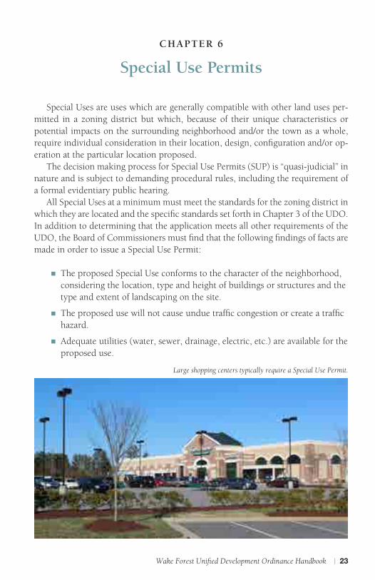
Large shopping centers typically require a Special Use Permit.

24 | C H A P T E R 6
n The proposed use shall not be noxious or offensive by reason of vibration, noise, odor, dust, smoke or gas.
n The establishment of the proposed use shall not impede the orderly development and improvement of surrounding property.
n The establishment, maintenance or operation of the proposed use shall not be detrimental to or endanger the public health, safety or general welfare.
n The application will not substantially injure the value of adjoining or abutting property.
n The proposed use is consistent with the officially adopted plans and policies of the town.
Some of the land uses that are typically associated with Special Use Permits are large shopping centers, public safety stations and wireless telecommunication towers.

Wake Forest Unified Development Ordinance Handbook | 25
CHAPTER 7
Major Plan Review
The major plan review process is divided into two categories: Major Site Master Plans and Major Subdivision Master Plans. These are plans that can only be ap-proved if certain specified findings per the UDO are met.
The decision making process for a major plan review is “quasi-judicial” and is subject to demanding procedural rules, including the requirement of a formal evi-dentiary public hearing.
The Major Subdivision Master Plan review process is required for divisions of land into four or more lots, or which require dedication of public utilities and/or public streets. The Major Site Master Plan review process includes all residential de-velopments over 100 units and any land use requiring an Enhanced Transportation Impact Analysis (see chart below):
Level of Study Requiredby Development Type
Residential Office Hotel Industrial orWarehouse
Retail/ ShoppingCenter
Other
None (unless located in area of special concern)
<100 units <50,000 sf <100rooms
<150employees
n/a <100 peakhour trips
Standard TIA 100 to 500units
50,000 sf to350,000 sf
100 to500rooms
150 to 1,000employees
<100,000 sf 100 to 500peak hourtrips
Enhanced TIA >500 units >350,000sf
>500rooms
>1,000employees
>100,000 sf >500 peakhour trips
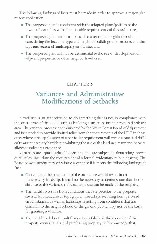
The following findings of facts must be made in order to approve a major plan review application:
n The plan is consistent with the adopted plans and policies of the town;
n The plan complies with all applicable requirements of the UDO;
n There exists adequate infrastructure (transportation and utilities) to support the plan as proposed; and
n The application will not be detrimental to the use or development of adjacent properties or other neighborhood uses.
Some of the land uses that may require major plan review are apartment com-plexes, hotels and large shopping centers.

26 | C H A P T E R 8
CHAPTER 8
Major Architectural Design Review
The UDO establishes building design standards for all developments throughout the Town of Wake Forest’s jurisdiction. Certain development projects as outlined in Section 15.8.5 of the UDO require specific architectural standards for review and approval by the Wake Forest Design Review Board. The review of these particular projects is considered a Major Architectural Design Review. These requests can only be approved if certain specified findings per the UDO are met. The decision making process for a Major Architectural Design Review is “quasi judicial” and is subject to demanding procedural rules, including the re-quirement of a formal evidentiary public hearing. The major architectural design review process applies to the following:
n RA-HC Zoning District: All development 6,000 square feet or greater in gross floor area (not in a Historic Overlay District);
n All Zoning Districts Except RA-HC: Non-residential development or expansion 10,000 square feet or greater in gross floor area;
n All mixed-use or non-residential projects in the UR, RMX, NMX or UMX Zoning Districts;
n All projects involving civic/institutional building types according to the provisions of Section 5.4 of the UDO (excluding any recreation facility under 2,500 square feet and any expansion or addition to an existing recreation facility);
n Multifamily developments containing eight or more units;
n Appeals from a decision of the administrator in a Minor Architectural Design Review.
Wake Forest Unified Development Ordinance Handbook | 27
The following findings of facts must be made in order to approve a major plan review application:
n The proposed plan is consistent with the adopted plans/policies of the town and complies with all applicable requirements of this ordinance;
n The proposed plan conforms to the character of the neighborhood, considering the location, type and height of buildings or structures and the type and extent of landscaping on the site; and
n The proposed plan will not be detrimental to the use or development of adjacent properties or other neighborhood uses.
CHAPTER 9
Variances and Administrative Modi�cations of Setbacks
A variance is an authorization to do something that is not in compliance with the strict terms of the UDO, such as building a structure inside a required setback area. The variance process is administered by the Wake Forest Board of Adjustment and is intended to provide limited relief from the requirements of the UDO in those cases where strict application of a particular requirement will create a practical diffi-culty or unnecessary hardship prohibiting the use of the land in a manner otherwise allowed under this ordinance.
Variances are “quasi-judicial” decisions and are subject to demanding proce-dural rules, including the requirement of a formal evidentiary public hearing. The Board of Adjustment may only issue a variance if it meets the following findings of fact:
n Carrying out the strict letter of the ordinance would result in an unnecessary hardship. It shall not be necessary to demonstrate that, in the absence of the variance, no reasonable use can be made of the property.
n The hardship results from conditions that are peculiar to the property, such as location, size or topography. Hardships resulting from personal circumstances, as well as hardships resulting from conditions that are common to the neighborhood or the general public, may not be the basis for granting a variance.
n The hardship did not result from actions taken by the applicant of the property owner. The act of purchasing property with knowledge that

28 | C H A P T E R 9
circumstances exist that may justify the granting of a variance shall not be regarded as a self-created hardship.
n The requested variance is consistent with the spirit, purpose and intent of this ordinance, such that the public safety is secured and substantial justice is achieved.
ADMINISTRATIVE MODIFICATION OF SETBACKS In keeping with the purpose of these regulations to accomplish coordinated, balanced, and harmonious development in a manner which will best promote the health, safety and general welfare while avoiding undue and unnecessary hardships, on approval by the town manager, the administrator is authorized to approve cer-tain requests for deviation from dimensional standards. Requests for deviation from required setbacks set forth in the UDO by up to 10% of the required setbacks or 24 inches, whichever is greater, may be considered upon determination that one or more of the conditions exist as written in Section 15.6.4 of the UDO.
VariancesA variance is an authorization to do something contrary to the strict terms of the UDO such as allowing a building to encroach within a required setback area.
Public Street Right of Way
A. Front Setback
B. Side Setback
C. Encroachment

Wake Forest Unified Development Ordinance Handbook | 29
CHAPTER 10
Certi�cate of Appropriateness
The Town of Wake Forest provides special coverage for historic neighborhoods and for historic landmark structures that exist within the Town’s jurisdiction. In or-der to provide this protection, the Town established the Historic District and Land-mark Overlay District in certain parts of the Town. The purpose of these “overlay districts” is to require special restrictions and controls on properties and buildings located within these areas.
These special restrictions require that a “certificate of appropriateness” be se-cured for any new construction, for any alteration of the exteriors of existing build-ings and for any demolition or removal of a structure or building.
There are two types of Certificates of Appropriateness (COA):
n Minor COA—Those exterior changes that do not involve substantial alterations, additions or removals that could impair the integrity of the property and/or historic district as a whole. These are reviewed and approved by the administrator.
n Major COA—Any exterior change that does not qualify for a Minor COA. These are reviewed and approved by the Historic Preservation Commission (HPC).
Major COA applications require a public hearing by the HPC to which they may approve, deny or approve with conditions. No Major COA shall be granted unless the commission finds that the application complies with the Secretary of Interior’s Standards for Rehabilitation and the Wake Forest Historic District Design Guidelines.
The Wake Forest Historic Preservation Commission approves major exterior changes in the Historic District.
A. Front Setback
B. Side Setback
C. Encroachment

30 | A P P E N D I X A
APPENDIX A
Administrative Agencies
THE ADMINISTRATOR Various provisions of the Unified Development Ordinance are administered un-der the general direction of the town manager and under the specific direction of the planning department, public works department, engineering department, and the City of Raleigh Public Utilities Department. The planning director, the director of public works, the director of engineering and their subordinate staffs are collectively referred to as the administrator throughout the UDO. The planning department serves as the “gatekeeper” for all development applications and advises applicants on appropriate personnel to contact.
TECHNICAL REVIEW COMMITTEE The purpose of the Technical Review Committee (TRC) is to bring key players from each town department as well as the City of Raleigh together in a meeting to discuss issues related to development and the plan review process. The TRC is com-posed of various members of the planning, public works, parks, recreation & cultur-al resources, engineering, administration, City of Raleigh Utilities, inspections and public safety departments. Most master and construction plans are reviewed by the TRC. Upon submittal of a plan to the planning department, the plans are distributed to each department and discussed at the next TRC meeting. Upon review of a plan by the TRC, a comprehensive set of staff review comments are sent to the applicant. TRC meetings are only attended by Town of Wake Forest staff members and are held on a monthly basis.
BOARD OF COMMISSIONERS Per the UDO, the Wake Forest Board of Commissioners shall render final decisions regarding the following permits and plans types:
n Major Site Master Plans
n Subdivision Master Plans/TND
n Special Use Permits
n Designation of Historic Landmarks/Districts
n Text Amendments
n Map Amendments/Rezoning
n Conditional District
n Vested Right

Wake Forest Unified Development Ordinance Handbook | 31
The Board of Commissioners convenes on the first and third Tuesday of each month in the Town Hall Board Room, 301 S. Brooks St. The Board’s monthly work session is scheduled on the first Tuesday of each month at 5:30 p.m. The Board’s regular monthly meeting is scheduled for the third Tuesday of each month at 7 p.m.
Advisory Boards
PLANNING BOARDThe purpose of the Wake Forest Planning Board is to perform studies and sur-
veys of the present conditions and probable future development of the town and its environs, including but not limited to, studies and surveys of land use, population, traffic, parking, annexation, expansion of extraterritorial jurisdiction, etc. The Plan-ning Board must also formulate recommendations to the board of commissioners on petitions related to zoning amendments, Special Use Permits and major site/subdivision master plans.
The Planning Board meets at 7:30 p.m. on the first Tuesday of each month, un-less otherwise noted, at the Wake Forest Town Hall, 301 S. Brooks St.
BOARD OF ADJUSTMENTThe purpose of the Wake Forest Board of Adjustment is to hear and decide
appeals where it is alleged by the appellant that there is error in any order, require-ment, permit, decision, determination, or refusal made by the administrator in the carrying out or enforcement of any provision of the UDO. The Board of Adjustment may also authorize variances from the terms of the UDO that will not be contrary to the public interest and where specific written findings per Chapter 14.5.1.B of the UDO are made.
The Board of Adjustment meets at 7 p.m. the third Thursday of each month (as needed).
DESIGN REVIEW BOARDThe purpose of the Wake Forest Design Review Board is to provide additional
discretionary review for developments where the Major Architectural Design Re-view process is applicable. The types of development subject to this review are listed in Chapter 15.8.5 of the UDO. The membership of the Design Review Board includes individuals with experience, training and demonstrated interest in design, construction, preservation, or planning for buildings, site design or landscaping.
The Design Review Board meets at 4 p.m. the second Thursday of each month (as needed).
32 | A P P E N D I X A
HISTORIC PRESERVATION COMMISSION The purpose of this commission is to safeguard the heritage of Wake Forest by preserving districts and landmarks that embody important elements of the Town’s culture, history, architectural history, or prehistory and to promote the use and conservation of such districts and landmarks for the education, pleasure, and en-richment of the residents of the town, the county and the state as a whole. The Historic Preservation Commission meets at 7 p.m. the second Wednesday of each month.

Wake Forest Unified Development Ordinance Handbook | 33
APPENDIX B
Land Use Table
Uses listed as (P) or (PS) which require an Enhanced Transportation Impact Analysis (according to Section 6.11.1) and all residential developments over 100 units are subject to the Major Site Plan Review Process established in Section 15.8.2. See UDO Appendix C —Typical Development Review Process Chart for more informa-tion regarding how the development process will be administered according to the use allowances established below.
RURAL SUBURBAN URBAN
USE TYPES OS RD GR 3
GR 5
GR 10
NB HB ICD LI HI UR RMX RA-HC
NMX UMX
A. RESIDENTIAL
Dwelling-Single Family — P P P P — — P — — P P — — —
Dwelling-Duplex — — — P P — — P — — P P — — —
Dwelling-Multifamily — — — — P — — P — — PS P P P P
Dwelling-Accessory — PS PS PS PS — — PS — — PS PS PS PS PS
Family Care Home (6 or fewer residents)
— PS PS PS PS PS — PS — — PS PS PS PS PS
Live-Work Units — — — — PS P P PS — — PS PS PS P P
Manufactured Housing – Class A
— PS — PS PS — — — — — SUP — — — —
Manufactured Housing – Class B & C
— SUP — SUP SUP — — — — — — — — — —
Manufactured Home Park — SUP — — — — — — — — — — — — —
Residential Care Facilities (more than 6 residents)
— — PS PS PS PS PS PS — — PS PS PS PS PS
B. LODGING
Bed and Breakfast Homes (up to 8 rooms)
— SUP SUP SUP — — — PS — — SUP PS PS PS PS
Boarding or Room-ing House (12 or less persons)
— — PS PS — PS PS PS — — PS PS PS PS PS
Dormitory — — — — — — — P — — — — — — —
Hotel/Inn (less than 20 rooms)
— — — — SUP P P P — — — P P P P
Hotel/Inn (no room limit) — — — — — P P P — — — — P P P
Uses indicated in table are subject to change by text amendments. Please verify with the Wake Forest Planning Department.
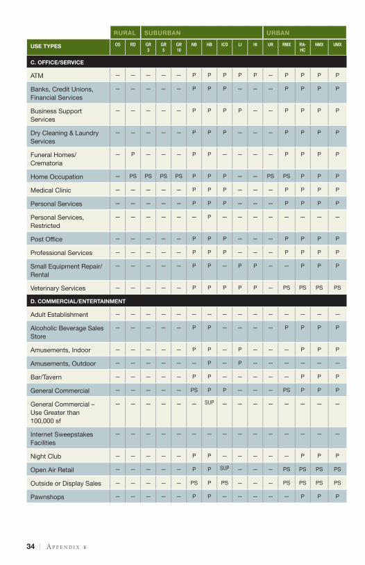
34 | A P P E N D I X B
RURAL SUBURBAN URBAN
USE TYPES OS RD GR 3
GR 5
GR 10
NB HB ICD LI HI UR RMX RA-HC
NMX UMX
C. OFFICE/SERVICE
ATM — — — — — P P P P P — P P P P
Banks, Credit Unions, Financial Services
— — — — — P P P — — — P P P P
Business Support Services
— — — — — P P P P — — P P P P
Dry Cleaning & Laundry Services
— — — — — P P P — — — P P P P
Funeral Homes/Crematoria
— P — — — P P — — — — P P P P
Home Occupation — PS PS PS PS P P P — — PS PS P P P
Medical Clinic — — — — — P P P — — — P P P P
Personal Services — — — — — P P P — — — P P P P
Personal Services, Restricted
— — — — — — P — — — — — — — —
Post Office — — — — — P P P — — — P P P P
Professional Services — — — — — P P P — — — P P P P
Small Equipment Repair/Rental
— — — — — P P — P P — — P P P
Veterinary Services — — — — — P P P P P — PS PS PS PS
D. COMMERCIAL/ENTERTAINMENT
Adult Establishment — — — — — — — — — — — — — — —
Alcoholic Beverage Sales Store
— — — — — P P — — — — P P P P
Amusements, Indoor — — — — — P P — P — — — P P P
Amusements, Outdoor — — — — — — P — P — — — — — —
Bar/Tavern — — — — — P P — — — — — P P P
General Commercial — — — — — PS P P — — — PS P P P
General Commercial – Use Greater than 100,000 sf
— — — — — — SUP — — — — — — — —
Internet Sweepstakes Facilities
— — — — — — — — — — — — — — —
Night Club — — — — — P P — — — — — P P P
Open Air Retail — — — — — P P SUP — — — PS PS PS PS
Outside or Display Sales — — — — — PS P PS — — — PS PS PS PS
Pawnshops — — — — — P P — — — — — P P P

Wake Forest Unified Development Ordinance Handbook | 35
RURAL SUBURBAN URBAN
USE TYPES OS RD GR 3
GR 5
GR 10
NB HB ICD LI HI UR RMX RA-HC
NMX UMX
Racetrack — — — — — — — — P P — — — — —
Restaurant — — — — — P P P — — — P P P P
Riding Stables — P P — — — — — — — — — — — —
Shooting Range, Outdoor — SUP — — — — — — SUP SUP — — — — —
Theater, Indoor Movie or Live Performance
— — — — — P P P — — — — P P P
Theater, Outdoor — — — — — — P P — — — — PS PS PS
E. CIVIC
Cemetery PS PS PS PS PS PS PS PS — — PS PS PS PS PS
Civic Meeting Facilities — P — — — P P P — — P P P P P
Community or Cultural Facility
— P P P P P P P — — P P P P P
Conference/Convention Center
— P — — — — P P — — — — — — P
Public Safety Station — SUP SUP SUP SUP P P P P P P P P P P
Recreation Facilities, Indoor
— P P P P P P P — — P P P P P
Recreation Facilities, Outdoor
P P P P P P P P — — P P P P P
Religious Institution — P P P P P P P — — P PS PS PS PS
Sports Arena/Stadium — — — — — — SUP SUP P — — — — — SUP
F. EDUCATIONAL/INSTITUTIONAL
Child/Adult Day Care Home (8 or less persons)
— P P P P P P P — — P P P P P
Child/Adult Day Care Center (More than 8 persons)
— PS — — — PS PS PS — — — PS PS PS PS
College/University — — — — — — — P — — — — — — —
Community Support Facility
— PS PS PS PS PS P P — — PS PS PS PS SUP
Correctional Institution — — — — — — — — SUP SUP — — — — —
Halfway Homes — — — — — SUP — — — — — SUP — SUP —
Hospital — — — — — — P P P — — — — — —
Schools – Elementary & Secondary
— PS PS PS PS PS PS PS — — PS PS PS PS PS
Schools – Vocational/Technical
— — — — — — — P — — — P P P P
Studio – Art, dance, martial arts, music
— — — — — P P P P — — P P P P

36 | A P P E N D I X B
RURAL SUBURBAN URBAN
USE TYPES OS RD GR 3
GR 5
GR 10
NB HB ICD LI HI UR RMX RA-HC
NMX UMX
G. AUTOMOTIVE
Drive-Thru/Drive-In Facility
— — — — — PS P — — — — — SUP SUP SUP
Gas/Fueling Station — — — — — PS P — — — — — — PS PS
Heavy Equipment/Man-ufactured Home Rental/Sales
— — — — — P P — P — — — — — —
Parking Lot/Structure – Principal Use
— — — — — P P P P P — P P P P
Theater, Drive-In — — — — — — P — P — — — — — —
Vehicle Rental/Leasing/Sales
— — — — — P P — P — — — — PS PS
Vehicle Rental – Moving Trucks
— — — — — P P — — — — PS PS PS PS
Vehicle Services – Minor Maintenance/Repair
— — — — — PS P — P P — — — PS PS
Vehicle Services – Major Repair/Body Work
— — — — — — P — P P — — — — —
H. INDUSTRY/WHOLESALE/STORAGE
Industry, Light — — — — — — PS — PS PS — — — — —
Industry, Heavy — — — — — — — — — PS — — — — —
Landfill — — — — — — — — — SUP — — — — —
Light Manufacturing Workshops
— — — — — P P — P P — P P P P
Materials Recovery & Waste Transfer Facilities
— — — — — — — — SUP PS — — — — —
Recycling Collection Stations
— — — — — PS PS PS PS PS — — — — —
Storage - Outdoor Storage Yard
— — — — — — P — P P — — — — —
Storage – Self-Service — — — — — PS PS — P P — — — — —
Storage – Warehouse, Indoor Storage
— — — — — — — — P P — — — — —
Wholesaling and Distribution
— — — — — — — — P P — — — — —
I. AGRICULTURE
Animal Production — SUP SUP — — — — — — — — — — — —
Backyard Pens/Coops — P PS PS PS PS PS PS — — PS PS PS PS PS
Nurseries & Garden Centers
P P P P — — — P — — — — — — —

Wake Forest Unified Development Ordinance Handbook | 37
RURAL SUBURBAN URBAN
USE TYPES OS RD GR 3
GR 5
GR 10
NB HB ICD LI HI UR RMX RA-HC
NMX UMX
Gardens (community and private)
P P P P P P P P P P P P P P P
Kennels, Outdoor — SUP — — — — PS — P P — — — — —
Produce Stands — PS PS PS PS PS PS PS — — PS PS PS PS PS
Swine Farms — — — — — — — — — — — — — — —
J. INFRASTRUCTURE
Airstrip — SUP SUP — — — — — SUP SUP — — — — —
Wireless Telecommunica-tions Tower
— SUP SUP SUP SUP SUP SUP SUP SUP SUP SUP SUP SUP SUP SUP
Wireless Telecommunica-tions Facility(non-tower)
— PS PS PS PS PS PS PS PS PS PS PS PS PS PS
Utilities – Class 1 — P P P P P P P P P P P P P P
Utilities – Class 2 — P P P P P P P P P P P P P P
Utilities – Class 3 — — — — — — — — P P — — — — —
K. OTHER
Temporary Uses See Section 4.7 for Specific Provisions

38 | A P P E N D I X C
APPENDIX C
Development Review Process Flow Chart
The charts on these pages illustrate the typical development review process that most projects in the Town of Wake Forest will follow. It is not intended to be inclusive of all the application/approval processes that may be required in every instance. For specif-ic information regarding what application/approval processes are required, contact the planning department.
Development Review Process
Determination of Use
Allowance
Use Table 2.3.3 in the UDO to determine
allowable use.
P Permitted
PS Permitted with Supplemental Standards, refer to UDO Chapter 3
SUP Requires Special Use Permit, refer to SUP Process (15.10)
or Pursue Rezoning (15.14) or Conditional District (15.15) to establish different district requirements
Proceed to subdivision, site plan and architectural design review processes on next page as needed.
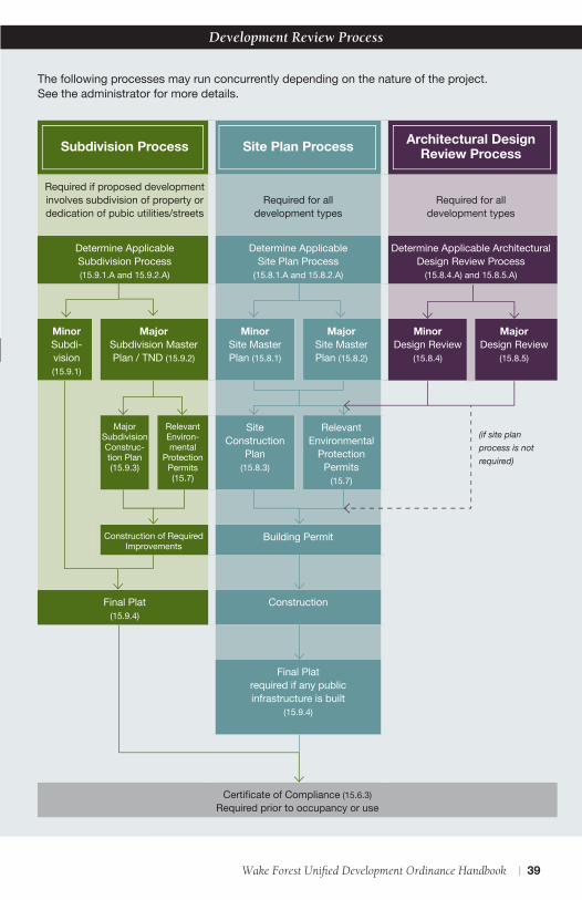
Wake Forest Unified Development Ordinance Handbook | 39
Subdivision Process Site Plan Process Architectural Design Review Process
Required if proposed development involves subdivision of property or dedication of pubic utilities/streets
Required for all development types
Required for all development types
Determine Applicable Subdivision Process (15.9.1.A and 15.9.2.A)
Determine Applicable Site Plan Process
(15.8.1.A and 15.8.2.A)
Determine Applicable Architectural Design Review Process
(15.8.4.A) and 15.8.5.A)
Minor Subdi-vision (15.9.1)
Major Subdivision Master Plan / TND (15.9.2)
Minor Site Master Plan (15.8.1)
Major Site Master Plan (15.8.2)
Minor Design Review
(15.8.4)
Major Design Review
(15.8.5)
Major Subdivision Construc-tion Plan (15.9.3)
Relevant Environ-mental
Protection Permits (15.7)
Site Construction
Plan (15.8.3)
Relevant Environmental
Protection Permits
(15.7)
Construction of Required Improvements
Building Permit
Final Plat (15.9.4)
Construction
Final Platrequired if any public infrastructure is built
(15.9.4)
Certificate of Compliance (15.6.3)Required prior to occupancy or use
(if site plan process is not required)
Development Review Process
The following processes may run concurrently depending on the nature of the project. See the administrator for more details.

40 | A P P E N D I X D
APPENDIX D
Glossary of Commonly Used Planning Terms
ACCESSORY USE OR STRUCTURE. A use or structure that is clearly incidental to and cus-tomarily found in connection with a principal building or use, is located on the same parcel and serves a principal building or use, and is subordinate in area, extent and purpose to the principal building or principal use served.
BED AND BREAKFAST HOMES (UP TO 8 ROOMS). A private home containing not more than eight guest rooms that offers bed and breakfast accommodations to guests.
BUFFER. A combination of physical space and vertical elements, such as plantings or fenc-ing, used to separate and screen incompatible land uses from each other.
BUFFERYARD. The area of a required buffer in which plantings or other screening ele-ments are to be located.
BUILDING. Any structure built for support, shelter or enclosure for any occupancy or storage.
CHANGE OF USE. For the purposes of this UDO only this term shall mean any alteration in the use of a lot or structure which, in the determination of the Administrator, chang-es the primary use of such lot or property from one use type listed in the Use Table in Section 2.3.3 to another use type.
CONDITIONAL DISTRICT. A zoning district with condition(s) voluntarily added by an applicant and approved in a legislative procedure by the board of commissioners in accordance with NCGS 160A-382.
CONSTRUCTION PLANS. A full and complete set of engineered drawings necessary for final permitting and construction.
CORNER LOT. A lot which abuts the right-of-way of two streets at their intersection.
DEVELOPMENT. Any land disturbing activity which adds to or changes the amount of impervious or partially pervious cover on a land area or which otherwise decreases the infiltration of precipitation into the soil, other than rebuilding activity that does not qualify as redevelopment.
DWELLING-ACCESSORY. A dwelling unit either detached or attached, such as a garage apartment or cottage, located on a lot with an existing single-family dwelling.
DWELLING-DUPLEX. A two-unit building that is divided horizontally or vertically, and each unit has a separate entrance from the outside or through a common vestibule.
DWELLING-MULTIFAMILY. A building, or portion thereof, containing three or more dwelling units on a single lot where each unit has a separate entrance from the outside or through a common vestibule. A multifamily structure where dwelling units are avail-able for lease or rent for less than one month shall be considered lodging.

Wake Forest Unified Development Ordinance Handbook | 41
DWELLING-SINGLE FAMILY. A freestanding building designed for and/or occupied by one household. These residences may be individually owned as residences or residenc-es owned by rental or management companies. Also includes factory-built, modular housing units that comply with NC State Building Code.
EASEMENT. A grant of one or more of the property rights by the property owner for limited use of private land for a public or quasi-public purpose and within which the owner of the property shall not erect any permanent structures except when authorized by the town.
FAMILY CARE HOME (6 OR FEWER RESIDENTS). A home with support and supervisory personnel that provides room and board, personal care and rehabilitation services in a family environment for not more than six resident handicapped persons and is certified by the State of North Carolina. (NCGS 168-21)
GREENWAY. A linear natural preserve available for free and unstructured recreation to the general public. This term is not meant to be inclusive of required pedestrian/bicycle connections from adjacent development to greenways.
HOME OCCUPATION. An occupation or profession conducted within a dwelling unit or accessory building by a residing family member that is incidental to the primary use of the dwelling as a residence. Home Occupations are small and quiet non-retail business-es generally invisible from the frontage, seldom visited by clients, requiring little park-ing, little or no signage, and having only one or two employees and provide services such as professional services, music instruction, and hair styling. Home Occupations include produce stands and day care centers where daytime care is provided to less than six children who are not the legal wards or foster children of the attendant adult within an owner-occupied residence.
IMPERVIOUS SURFACE. Impervious surface area includes any material which reduces and/or prevents absorption of storm water. This includes but is not limited to, build-ings, roads, pavement, gravel surfaces, etc.
MAJOR SUBDIVISION. Any subdivision of land into four or more lots, or which requires the dedication of public utilities and/or public streets.
MINOR SUBDIVISION. Any subdivision of land into three or fewer lots which does not require the dedication of public utilities and/or public streets.
MANUFACTURED HOUSING. A structure that: (a) consists of a single unit completely assembled at the factory or of multiple principal components totally assembled at the factory and joined together at the site; (b) is designed so that the total structure (or in the case of a double-wide or triple-wide, each component thereof) can be transported on its own chassis; (c) is over 40 feet long and over 10 feet wide; and, (d) is originally designed for human occupancy and provides complete, independent living facilities for one family when connected to required utilities.
MANUFACTURED HOUSING-CLASS A. A manufactured home constructed after July 1, 1998 that meets or exceeds the construction standards promulgated by the US Depart-ment of Housing and Urban Development authorized under the National Manufac-tured Housing Construction and Safety Standards Act of 1974 that were in effect at the time of construction, and has a HUD label attached.

42 | A P P E N D I X D
MANUFACTURED HOUSING-CLASS B. A double-wide manufactured home construct-ed to meet or exceed the construction standards promulgated by the US Depart-ment of Housing and Urban Development authorized under the National Manufac-tured Housing Construction and Safety Standards Act of 1974 that were in effect at the time of construction and has a HUD label attached, but does not meet the criteria of a Class A Manufactured Home.
MANUFACTURED HOME-CLASS C. A single-wide manufactured home constructed to meet or exceed the construction standards promulgated by the US Department of Housing and Urban Development authorized under the National Manufactured Housing Construction and Safety Standards Act of 1974 that were in effect at the time of construction and has a HUD label attached.
NEIGHBORHOOD PARKS. Improved space set aside for public use and recreation that is comprised of one or more of the following typologies (as outlined in Section 7.5.1): Park/Greenway, Green, Square, Playground, and Community Garden.
NONCONFORMITY. A lot, structure, or land use that is inconsistent with current regu-lations, but which was entirely lawful when it was originally established.
OVERLAY DISTRICT. A zoning district that applies development standards in addition to the requirements of the underlying or “base” zoning district.
RESIDENTIAL CARE FACILITIES. A staffed premises (not a single-family dwelling) with paid or volunteer staff that provides full-time care to more than six individu-als. Residential care facilities include group homes (NCGS §131D), nursing homes (NCGS § 131E-101), residential child-care facilities (NCGS § 131D-10.2), assisted living residences (NCGS § 131D-2), adult care homes (NCGS §131D-2), retire-ment housing, congregate living services, assisted living services, continuing care retirement centers, skilled nursing services and orphanages. This term excludes family care homes and halfway houses.
REZONING/MAP AMENDMENT. An amendment to the official zoning map to move property from one zoning district to another district.
SETBACK (MINIMUM). A line parallel to the front property line in front of which no structure shall be erected. Setbacks shall be figured from the right-of-way line.
SIGN. Any device, fixture, placard or structure that uses any color, form, graphic, illumination, symbol or writing to advertise, announce the purpose of, or identify the purpose of a person or entity, or to communicate information of any kind to the public.
SITE PLAN. A plan and/or review process for any type of development or building activity on a wparticular parcel or parcels of land.
SPECIAL FLOOD HAZARD AREA (SFHA). The land in the floodplain subject to a 0.2% or greater chance of being flooded in any given year based on current conditions hydrology.
SPECIAL USE PERMIT. A permit required for a use that is allowed in a particular zon-ing district only if conditions specified in the ordinance are met.

Wake Forest Unified Development Ordinance Handbook | 43
SUBDIVISION. All divisions of a tract or parcel of land into two or more lots, building sites, or other divisions for the purpose of sale, or building development (whether immediate or future) and shall include all divisions of land involving the dedica-tions of a new street or a change in existing streets.
TEMPORARY USE. A land use on an individual parcel or site established for a limited and fixed period of time for a purpose which may not normally be permitted in a zoning district, or which does not meet all zoning requirements, but which is necessary in special situations.
VARIANCE. An authorization to do something contrary to the strict terms of an ordi-nance, such as building a structure inside a required setback.
