handbook introduction revised - florida … range estimates handbook fdot state estimates office...
TRANSCRIPT

Long Range Estimates Handbook
FDOT State Estimates Office April 2007
INTRODUCTION The Long Range Estimates system is a construction cost estimating system owned and operated by the Florida Department of Transportation, and accessed through the internet. Use is strictly limited to FDOT projects, and access is only available to qualified FDOT personnel and private consultants working on active FDOT contracts. All users must be properly trained in LRE prior to obtaining access to the system. When a project has been identified as a candidate for inclusion in the FDOT Work Program, the FDOT Project Manager will request that the District Estimates Office create an LRE. Projects cannot be added to the Work Program without an LRE-based cost estimate. Conceptual vs. Design Estimates An LRE is a conceptual estimate, prepared before design plans and quantities are available. The system uses project-specific design characteristics to calculate quantities, and draws unit prices from an extensive database of FDOT historical bid prices. The design characteristics may be either assumed values that are considered to be “average” conditions for that type of project, or they may be the actual characteristics of the project if that information is known at the time the estimate is performed. Under normal circumstances, when quantities are developed at the 90% plans stage, the estimate will be developed through the use of the TRNS*PORT system, and the LRE (conceptual) estimate will no longer be used. This timeline puts it in perspective:
PD&E Initial Work Program through 60% Plans
LRE
Initial Work Program 30% 60%
60% through Advertisement
PES/CES
90% 100%
TRNS*PORT
Bid Letting
Advertisement through Award
Award
LAS
Construction
Site Manager

Long Range Estimates Handbook
FDOT State Estimates Office April 2007
USER ACCESS LRE is an access-controlled internet application. In order to access LRE, consultant users must first obtain an FDOT user ID. To do this, a written application (FDOT Computer Security Access Request Form 325-060-05) must be submitted to the FDOT Project Manager. Prior to submittal applicants must read the FDOT security policies and complete a new user’s course. Web links to this material are noted on the application. The PM will direct the application to the proper FDOT computer security personnel, who will issue a user ID. For complete instructions, see the following website: http://www.dot.state.fl.us/computersecurity/Consultants/ConsultantInstructions.pdf For the Request Form, see: http://www.dot.state.fl.us/computersecurity/Forms_Docs/32506005.pdf
Long Range Estimates Handbook
FDOT State Estimates Office April 2007
PROJECT LEVELS IN LRE
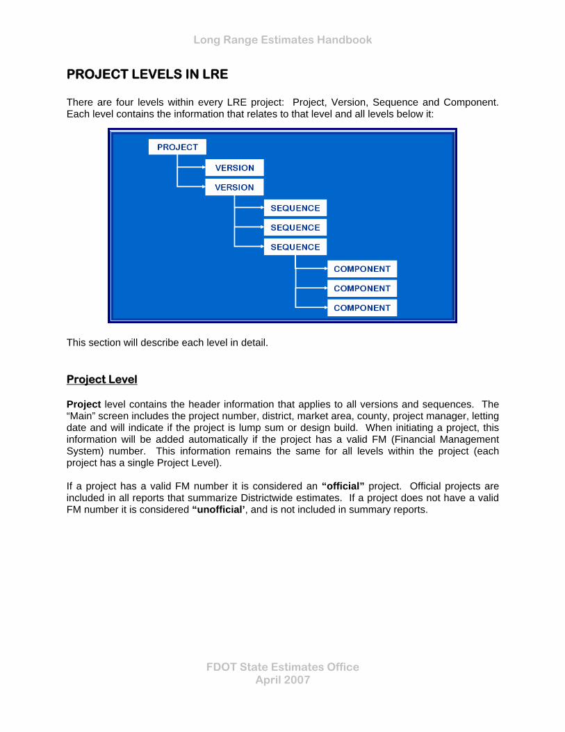
There are four levels within every LRE project: Project, Version, Sequence and Component. Each level contains the information that relates to that level and all levels below it:
This section will describe each level in detail. Project Level Project level contains the header information that applies to all versions and sequences. The “Main” screen includes the project number, district, market area, county, project manager, letting date and will indicate if the project is lump sum or design build. When initiating a project, this information will be added automatically if the project has a valid FM (Financial Management System) number. This information remains the same for all levels within the project (each project has a single Project Level). If a project has a valid FM number it is considered an “official” project. Official projects are included in all reports that summarize Districtwide estimates. If a project does not have a valid FM number it is considered “unofficial’, and is not included in summary reports.
Long Range Estimates Handbook
FDOT State Estimates Office April 2007
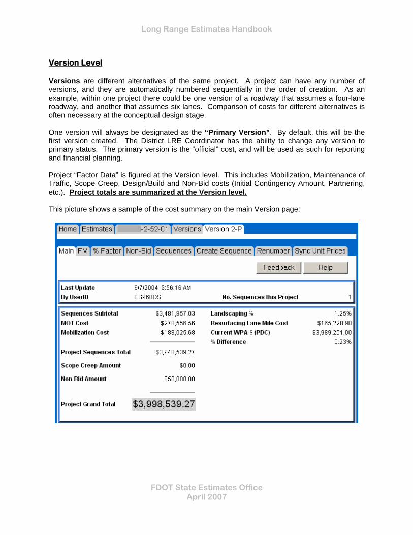
Version Level Versions are different alternatives of the same project. A project can have any number of versions, and they are automatically numbered sequentially in the order of creation. As an example, within one project there could be one version of a roadway that assumes a four-lane roadway, and another that assumes six lanes. Comparison of costs for different alternatives is often necessary at the conceptual design stage. One version will always be designated as the “Primary Version”. By default, this will be the first version created. The District LRE Coordinator has the ability to change any version to primary status. The primary version is the “official” cost, and will be used as such for reporting and financial planning. Project “Factor Data” is figured at the Version level. This includes Mobilization, Maintenance of Traffic, Scope Creep, Design/Build and Non-Bid costs (Initial Contingency Amount, Partnering, etc.). Project totals are summarized at the Version level. This picture shows a sample of the cost summary on the main Version page:
Long Range Estimates Handbook
FDOT State Estimates Office April 2007
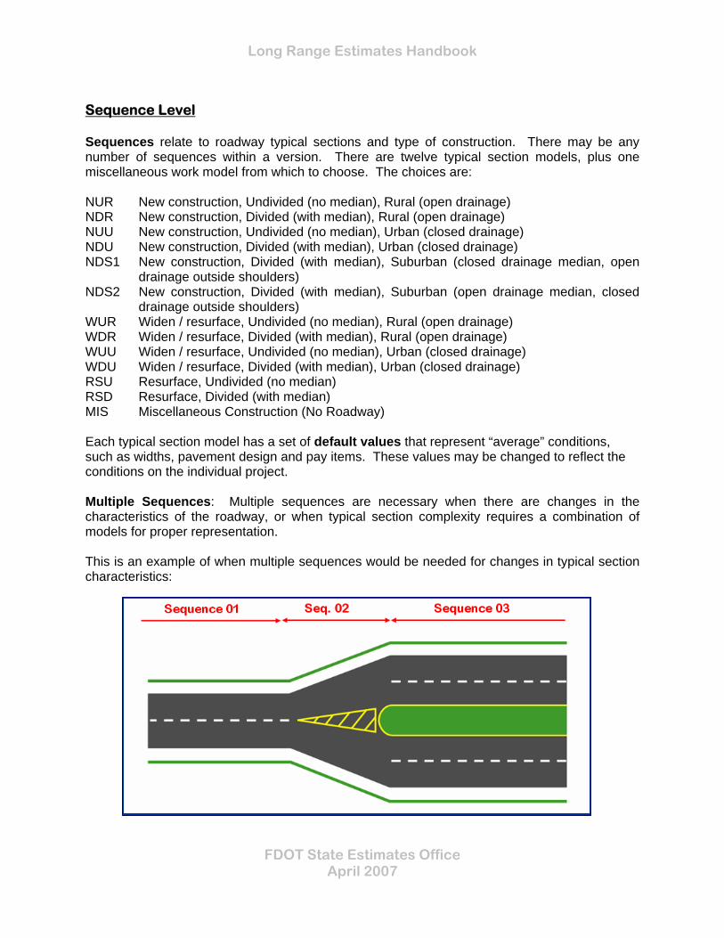
Sequence Level Sequences relate to roadway typical sections and type of construction. There may be any number of sequences within a version. There are twelve typical section models, plus one miscellaneous work model from which to choose. The choices are: NUR New construction, Undivided (no median), Rural (open drainage) NDR New construction, Divided (with median), Rural (open drainage) NUU New construction, Undivided (no median), Urban (closed drainage) NDU New construction, Divided (with median), Urban (closed drainage) NDS1 New construction, Divided (with median), Suburban (closed drainage median, open
drainage outside shoulders) NDS2 New construction, Divided (with median), Suburban (open drainage median, closed
drainage outside shoulders) WUR Widen / resurface, Undivided (no median), Rural (open drainage) WDR Widen / resurface, Divided (with median), Rural (open drainage) WUU Widen / resurface, Undivided (no median), Urban (closed drainage) WDU Widen / resurface, Divided (with median), Urban (closed drainage) RSU Resurface, Undivided (no median) RSD Resurface, Divided (with median) MIS Miscellaneous Construction (No Roadway) Each typical section model has a set of default values that represent “average” conditions, such as widths, pavement design and pay items. These values may be changed to reflect the conditions on the individual project. Multiple Sequences: Multiple sequences are necessary when there are changes in the characteristics of the roadway, or when typical section complexity requires a combination of models for proper representation. This is an example of when multiple sequences would be needed for changes in typical section characteristics:

Long Range Estimates Handbook
FDOT State Estimates Office April 2007
This is an example of when multiple sequences would be needed for a complex typical section: Component Level Components relate to specific pay item groups and types of work (for example, Earthwork, Roadway, Drainage are each separate components). Some components have related subcomponents (for example, the Drainage component has 2 subcomponents: Retention Basins and Box Culverts). Components are either required or optional, based on the chosen typical section (for example, Earthwork, Roadway, Shoulder, Drainage and Signing are required components on all New Construction models). Required components will be generated automatically when the typical section model is chosen; optional components may be added where necessary. This picture shows the component selection screen; the required components for the selected model are pre-selected:
Long Range Estimates Handbook
FDOT State Estimates Office April 2007
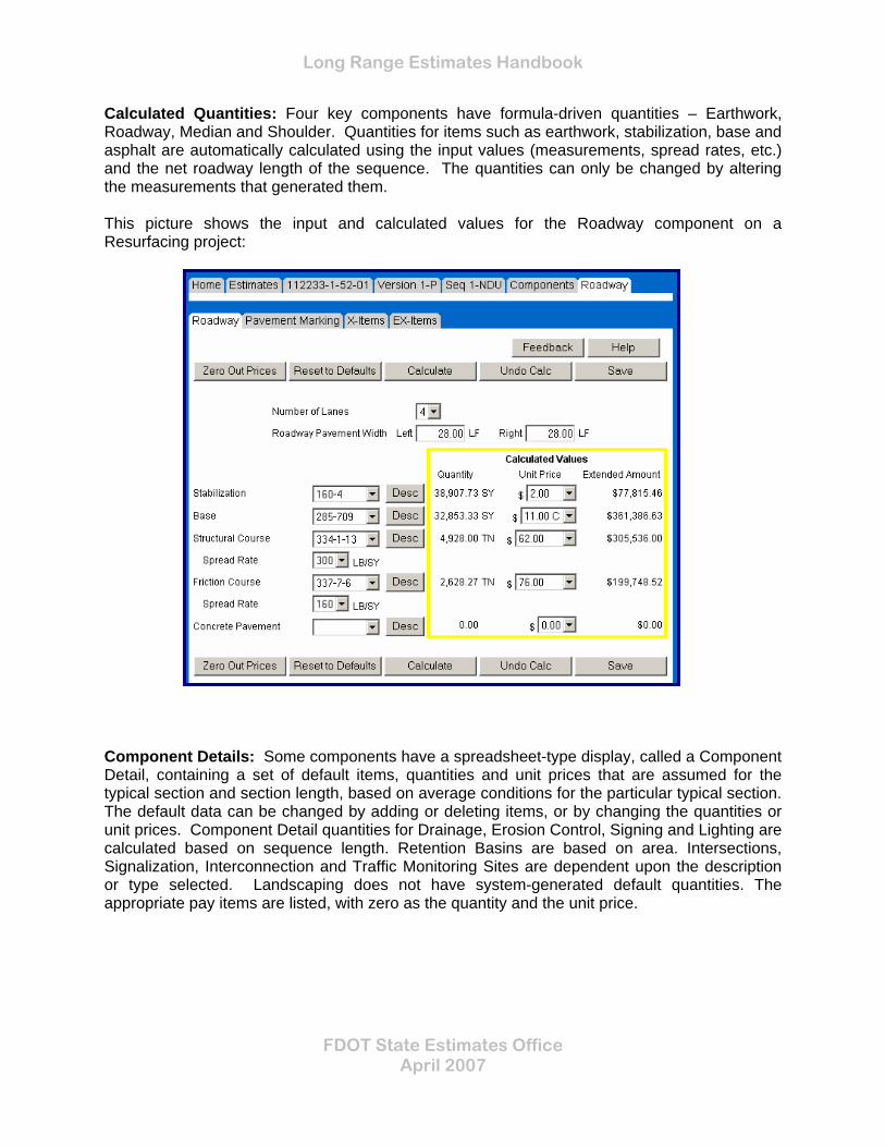
Calculated Quantities: Four key components have formula-driven quantities – Earthwork, Roadway, Median and Shoulder. Quantities for items such as earthwork, stabilization, base and asphalt are automatically calculated using the input values (measurements, spread rates, etc.) and the net roadway length of the sequence. The quantities can only be changed by altering the measurements that generated them. This picture shows the input and calculated values for the Roadway component on a Resurfacing project:
Component Details: Some components have a spreadsheet-type display, called a Component Detail, containing a set of default items, quantities and unit prices that are assumed for the typical section and section length, based on average conditions for the particular typical section. The default data can be changed by adding or deleting items, or by changing the quantities or unit prices. Component Detail quantities for Drainage, Erosion Control, Signing and Lighting are calculated based on sequence length. Retention Basins are based on area. Intersections, Signalization, Interconnection and Traffic Monitoring Sites are dependent upon the description or type selected. Landscaping does not have system-generated default quantities. The appropriate pay items are listed, with zero as the quantity and the unit price.

Long Range Estimates Handbook
FDOT State Estimates Office April 2007
This picture shows a sample component detail for Signing:
Individual items can be deleted by checking the box to the left of the item number. Items can be added by clicking on the Add X-Items or Add EX-Items buttons at the bottom of the window. Quantities can be adjusted by typing over the default quantity. Unit prices can be adjusted by selecting from the County, Market Area or Statewide prices from the drop-down OR by typing in a custom price.

Long Range Estimates Handbook
FDOT State Estimates Office April 2007
CREATING A NEW LRE To create a new LRE choose the “Create Project” tab on the “Estimates” screen.
On the Create Project screen, input the FPID of the project and choose either English or Metric units. If the FPID is not known at the time the project is created, you can assign a fictitious number for temporary usage (this is an alphanumeric field, so you can use any identifier). Later, when you know the FPID, you can have your District Coordinator change the project number.
It is important to understand that when you create a project, you are creating the first Version, and the first Sequence of that Version. You cannot create an “empty” project – there must be details and an actual estimate on every LRE project.
Creating the First Version and Sequence: When you have entered the FPID number and chosen the units of measure, click on the Continue button. You will be presented with the Sequence Selection screen, where you choose the typical section model for the first sequence of the first version:
Long Range Estimates Handbook
FDOT State Estimates Office April 2007
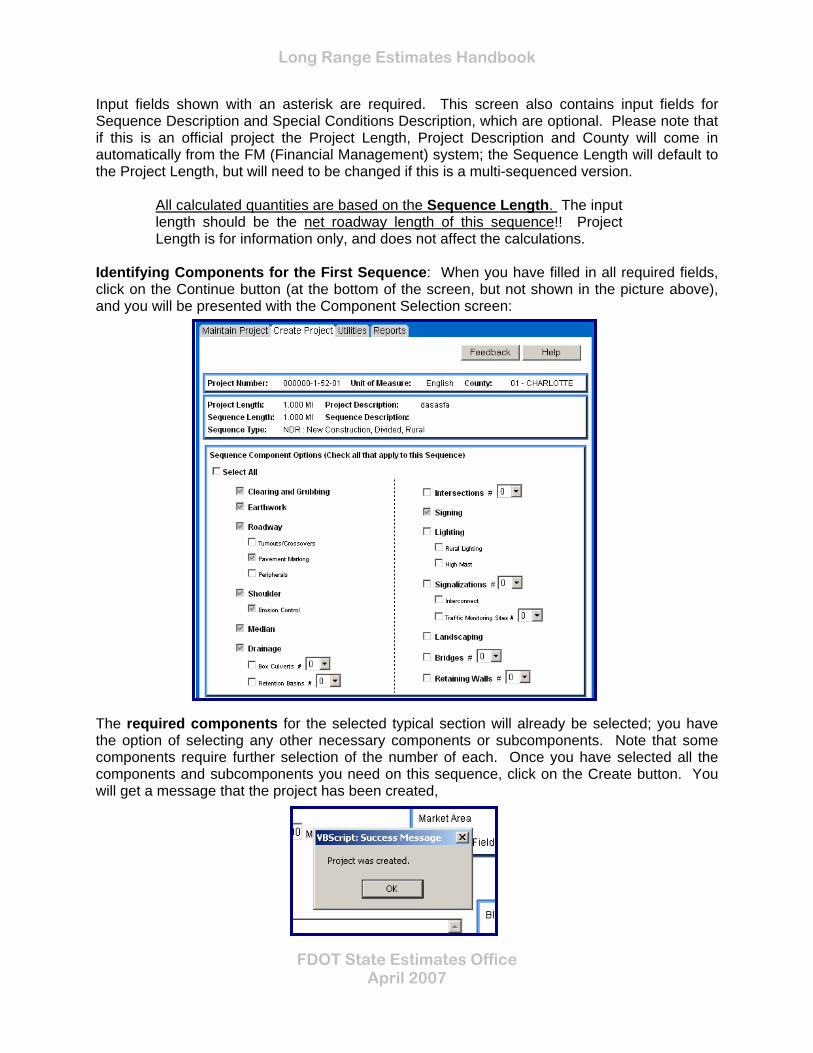
Input fields shown with an asterisk are required. This screen also contains input fields for Sequence Description and Special Conditions Description, which are optional. Please note that if this is an official project the Project Length, Project Description and County will come in automatically from the FM (Financial Management) system; the Sequence Length will default to the Project Length, but will need to be changed if this is a multi-sequenced version.
All calculated quantities are based on the Sequence Length. The input length should be the net roadway length of this sequence!! Project Length is for information only, and does not affect the calculations.
Identifying Components for the First Sequence: When you have filled in all required fields, click on the Continue button (at the bottom of the screen, but not shown in the picture above), and you will be presented with the Component Selection screen:
The required components for the selected typical section will already be selected; you have the option of selecting any other necessary components or subcomponents. Note that some components require further selection of the number of each. Once you have selected all the components and subcomponents you need on this sequence, click on the Create button. You will get a message that the project has been created,

Long Range Estimates Handbook
FDOT State Estimates Office April 2007
and the Main Project screen will appear.
Selecting the Version and Sequence for Editing: The next step is to select the Version (since this is a newly created project, there is only one Version available). Click on the Versions Tab, and the Version selection screen will appear:
Click on the Select button for the Version, and you will be presented with the Version Main page (refer to Version Level, in the Project Levels section of this handbook). This picture shows the top part of the Version Main page:

Long Range Estimates Handbook
FDOT State Estimates Office April 2007
The next step is to select the Sequence (since this is a newly created project, there is only one Sequence available). Click on the Sequences Tab, and the Sequence selection screen will appear:
Click on the Select button for the Sequence, and you will be presented with the Component Selection screen. The required and previously selected components will be checked.:

Long Range Estimates Handbook
FDOT State Estimates Office April 2007
From here, you can either click on the Add Components Tab, to include additional Components on this Sequence, or you can choose the Components Tab, to get a listing of the currently selected Components:
From here, the project can be edited by selecting one Component at a time. In the Components, each data input screen will have a Help button, at the top right side of the screen, which contains field-level information as an aid. MAINTAINING AN EXISTING LRE To maintain or edit an existing LRE choose the “Maintain Project” tab on the “Estimates” screen.
Input the project number (FPID), if available, or use the search function to locate your project from a list of existing LREs. When you have chosen the project, the main page will appear:

Long Range Estimates Handbook
FDOT State Estimates Office April 2007
From here, you will choose the version you want to edit. You can either click on the Versions tab to get a listing of current versions, or click on the Create Version tab if you want to create a new version. If you choose to create a new version, then you will have to identify the sequence type (typical section model) and identify the components you will need, as described in the Create Project chapter.

Long Range Estimates Handbook
FDOT State Estimates Office April 2007
EARTHWORK
Earthwork quantities are calculated for new construction and widening models. They are not calculated for resurfacing (resurfacing models do not allow for the addition of paved shoulders – a widening model should be used if new paved shoulders are being constructed). The LRE program uses end area measurements, applied to a length (alignment distance), to calculate earthwork quantities. The fill height and slope data from the Earthwork Alignment pages are used in the calculations, along with a variety of information from the Roadway, Median and Shoulder components. These quantities are based on finished cross sections, with no fluff factor allowance. Part of the calculation equation uses the difference between original ground elevations and profile grade elevations. The original ground line elevation defaults to 100 feet. This is just an arbitrary number. The important thing to remember is the difference between the two elevations should reflect project conditions. This picture shows the input screen for Earthwork on a New Construction model, with the default values for fill height and slopes: For widening models, there are input fields for both the existing conditions and the new conditions.

Long Range Estimates Handbook
FDOT State Estimates Office April 2007
EARTHWORK ITEMS Embankment (item 120-6) will be generated if the profile grade (PGL) is greater than the original ground line (OGL). Regular excavation (120-1) will be generated if the opposite is true. Borrow excavation (120-2-2) will be generated on widening models, the assumption being that the widened area needs to be built up. This picture shows the area that is calculated for Embankment:
This picture shows the area that is calculated for Excavation: This picture shows the area that is calculated for Borrow:
Long Range Estimates Handbook
FDOT State Estimates Office April 2007
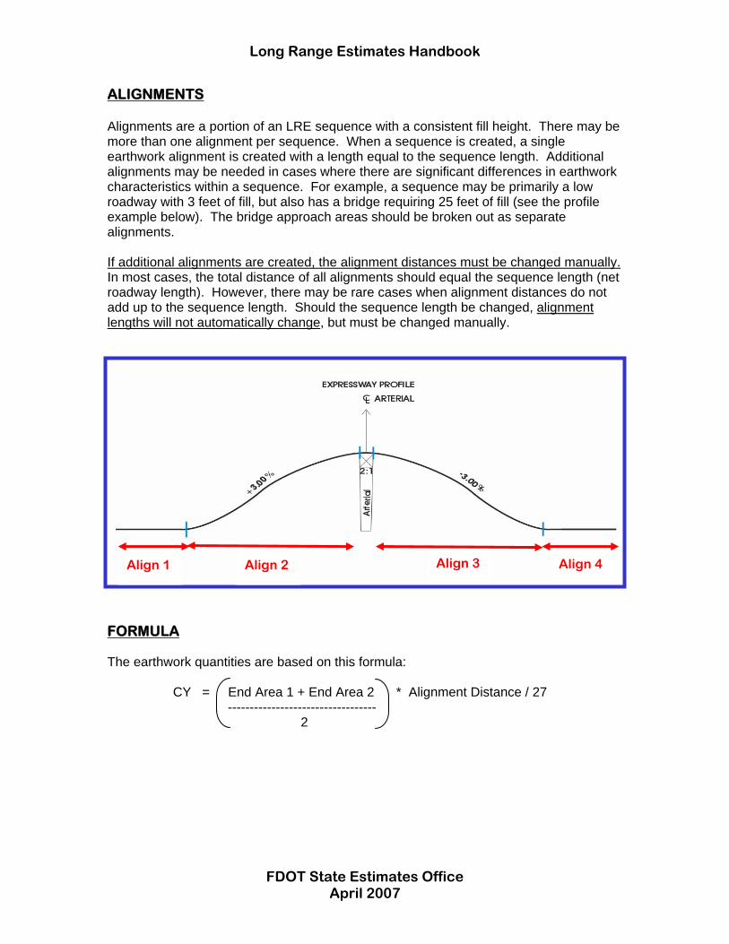
ALIGNMENTS Alignments are a portion of an LRE sequence with a consistent fill height. There may be more than one alignment per sequence. When a sequence is created, a single earthwork alignment is created with a length equal to the sequence length. Additional alignments may be needed in cases where there are significant differences in earthwork characteristics within a sequence. For example, a sequence may be primarily a low roadway with 3 feet of fill, but also has a bridge requiring 25 feet of fill (see the profile example below). The bridge approach areas should be broken out as separate alignments. If additional alignments are created, the alignment distances must be changed manually. In most cases, the total distance of all alignments should equal the sequence length (net roadway length). However, there may be rare cases when alignment distances do not add up to the sequence length. Should the sequence length be changed, alignment lengths will not automatically change, but must be changed manually.
FORMULA The earthwork quantities are based on this formula: CY = End Area 1 + End Area 2 * Alignment Distance / 27 ---------------------------------- 2
Align 1 Align 2 Align 3 Align 4