handbook for 14th rto 6th capital and 4th comstock 2018
TRANSCRIPT

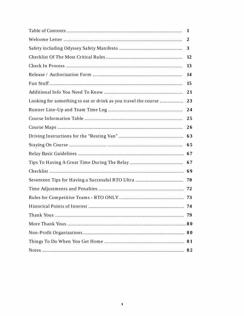
Table of Contents ......................................................................................... 1 Welcome Letter ............................................................................................ 2 Safety including Odyssey Safety Manifesto ................................................. 3 Checklist Of The Most Critical Rules ........................................................... 12 Check In Process .......................................................................................... 13 Release / Authorization Form ..................................................................... 14 Fun Stuff ....................................................................................................... 15 Additional Info You Need To Know ............................................................. 21 Looking for something to eat or drink as you travel the course .................. 23 Runner Line-Up and Team Time Log .......................................................... 24 Course Information Table ............................................................................ 25 Course Maps ................................................................................................. 26 Driving Instructions for the "Resting Van" .................................................. 63 Staying On Course ............................. .......................................................... 65 Relay Basic Guidelines .................................................................................. 67 Tips To Having A Great Time During The Relay ......................................... 67 Checklist ........................................................................................................ 69 Seventeen Tips for Having a Successful RTO Ultra ..................................... 70 Time Adjustments and Penalties .................................................................. 72 Rules for Competitive Teams - RTO ONLY .................................................. 73 Historical Points of Interest .......................................................................... 74 Thank Yous .................................................................................................... 79 More Thank Yous ............................................................................................ 80 Non-Profit Organizations .............................................................................. 80 Things To Do When You Get Home .............................................................. 81 Notes .............................................................................................................. 82
1

Hello Runners, Welcome to the 14th Annual Reno-Tahoe Odyssey Relay Run Adventure, the 6th Annual Capital Odyssey Relay and the 4th Annual Comstock Odyssey Relay! Thanks for signing up to run in one of our relays! We have just a few course changes since last year. We have a new Exchange Point 6, so Legs 6 and 7 end and start at a different place respectively. There will be a railroad crossing on the new parts of Legs 6 and 7, so please be extra careful there. In addition, Leg 34 has been revised a bit at the outset of that leg. New leg maps and the updated course info table are included here and posted on the website. We have a new location in downtown Reno for packet pick-up and the captains meeting on May 31: the plaza outside of the Pioneer Center for the Performing Arts at 100 S. Virginia Street. This is a great part of downtown with lots of good spots for eating, drinking and having other fun. We will have a new race app this year from RaceJoy. It has some different bells and whistles … literally. We hope you enjoy it. And of course some new swag. Check out the online store for a preview. Otherwise you can expect the same great event. A spectacular course, with many snow capped mountains and roaring rivers and streams. All the fun contests. The Leg 4 Time Trial where we will crown the fastest man and fastest women, and 178th place will score a great prize too. A fun Finish Line Festival where you can celebrate your accomplishment; we will be treating every runner to a complimentary beer. Will any of you be joining the RTO Circle of Fame? If after this year you will have run every one of the 36 legs in your RTO career, please let us know so we can have your well deserved prize ready for you. If it is REALLY hot on Saturday June 2, we have a procedure to deal with starting teams’ second vans a little early in Virginia City. Given the size and popularity of the RTO, we have rules that we need you to continue to follow. See our critical rules summary. Once again there will be a lot of runners and vans , so be alert and patient. Please check in with the volunteers at each exchange point so we can keep track of your team. Please be very familiar with the legs you are running. See the Staying On Course tips inside. Vans should be at the turns to make sure the runners stay on course. Please donate separately to the Northern Nevada Children’s Cancer Foundation or the Tahoe-Pyramid Bikeway. Thanks again for joining us this year. Please thank the volunteers. Be safe. Have a blast. Best regards, Eric Lerude
2
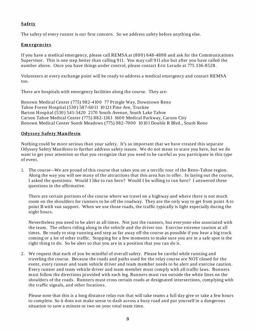
Safety The safety of every runner is our first concern. So we address safety before anything else. Emergencies If you have a medical emergency, please call REMSA at (800) 648-4888 and ask for the Communications Supervisor. This is one step better than calling 911. You may call 911 also but after you have called the number above. Once you have things under control, please contact Eric Lerude at 775 336-8528. Volunteers at every exchange point will be ready to address a medical emergency and contact REMSA too. There are hospitals with emergency facilities along the course. They are: Renown Medical Center (775) 982-4100 77 Pringle Way, Downtown Reno Tahoe Forest Hospital (530) 587-6011 10121 Pine Ave, Truckee Barton Hospital (530) 541-3420 2170 South Avenue, South Lake Tahoe Carson Tahoe Medical Center (775) 882-1361 1600 Medical Parkway, Carson City Renown Medical Center South Meadows (775) 982-7000 10101 Double R Blvd., South Reno Odyssey Safety Manifesto Nothing could be more serious than your safety. It’s so important that we have created this separate Odyssey Safety Manifesto to further address safety issues. We do not mean to scare you here, but we do want to get your attention so that you recognize that you need to be careful as you participate in this type of event. 1. The course—We are proud of this course that takes you on a terrific tour of the Reno-Tahoe region.
Along the way you will see many of the attractions that this area has to offer. In laying out the course, I asked the questions: Would I like to run here? Would I be willing to run here? I answered these questions in the affirmative. There are certain portions of the course where we travel on a highway and where there is not much room on the shoulders for runners to be off the roadway. They are the only way to get from point A to point B with van support. When we use those roads, the traffic typically is light especially during the night hours. Nevertheless you need to be alert at all times. Not just the runners, but everyone else associated with the team. The others riding along in the vehicle and the driver too. Exercise extreme caution at all times. Be ready to stop running and step as far away off the course as possible if you hear a big truck coming or a lot of other traffic. Stopping for a few moments to make sure you are in a safe spot is the right thing to do. So be alert so that you are in a position that you can do it.
2. We request that each of you be mindful of overall safety. Please be careful while running and
traveling the course. Because the roads and paths used for the relay course are NOT closed for the event, every runner and team vehicle driver and team member needs to be alert and exercise caution. Every runner and team vehicle driver and team member must comply with all traffic laws. Runners must follow the directions provided with each leg. Runners must run outside the white lines on the shoulders of the roads. Runners must cross certain roads at designated intersections, complying with the traffic signals, and other locations. Please note that this is a long distance relay run that will take teams a full day give or take a few hours to complete. So it does not make sense to dash across a busy road and put yourself in a dangerous situation to save a minute or two on your total team time.
3

Team vehicles – Team vehicles should act as an additional safeguard for runners. They can do that in at least two ways. One is to display the “Runners on Road” sign that we provide to you. Place the sign on the back of the vehicle in a conspicuous location. We will provide each team with two signs, one for each vehicle. If you have extra ones, use them. In addition, team vehicles can help manage the speed of the traffic and slow down faster drivers by driving in compliance with the posted speed limits. For almost the entire course the team vehicle should be close by, for the team vehicle travels the very same steps of the runner. The team vehicle should keep the runner in sight if possible. The team vehicle can be an extra direction sign waiting at or near the turns in the course. Team vehicles should not cause traffic and safety issues. Team vehicles may not drive next to runners, as this may cause a traffic hazard. Team vehicles must park safely off of the roadways and not block access to other roads or driveways. Team vehicles should not speed along the course endangering other teams’ runners. Please drive at safe speeds at all times. You of all people know there is a running event that is occurring on that road that you are traveling. So drive slowly. Do not place any signs or decorations on the vehicle that block your views out of windows of the vehicle.
3. Night running -- From sunset to sunrise runners are required to wear a lighted vest or a reflective vest
with a blinking light, and carry a lighted flashlight or wear a headlamp. As a precautionary matter, we encourage runners to wear reflective vests at all times. We strongly urge you to stay in your van between sunset and sunrise unless you are running or safely within the confines of a transition area. Should you determine it is absolutely necessary to be outside your van at night, you must be wearing a reflective vest and you must have a light attached to you or in your hand. Everyone needs to be alert. Traffic may expect runners along the road but they will not expect anyone darting across the road to support or cheer on a runner. So everyone, not just the runner, must be careful at all times. For many runners this is their favorite run of their 3 legs and this is their favorite time of the relay. It can be such a great experience. Enjoy the moment, but be alert.
4. Drinking and driving—This is a serious issue. The laws that prohibit motorists from drinking and
driving obviously apply to our participants too. 5. Escorts – At any part of the relay a runner may be accompanied by another runner. But please no
bike escorts except on Leg 4 or on bike paths. On certain roads a bike escort creates a traffic and safety hazard.
6. Runners CANNOT use headphones on Legs 8 through 32. 7. Permits, law enforcement, signs, a system for emergencies, and lots of volunteers — We take many,
many steps to make this event a safe experience. Those steps include the following: Every single mile of our course is permitted by appropriate authorities. It’s more important that everyone finish safely than anything else. A permitted race is one that has been “vetted” by local authorities. We don’t consider that a hassle. We consider it a necessity. We work closely with the law enforcement authorities. We contract with them to patrol certain parts of the course and help with traffic controls services. We pay them to do it. We’re happy to have them involved in the event. So expect to see California Highway Patrol and Nevada Highway Patrol officers again and again. In addition, we put up changeable message boards and “Special Event Ahead” signs along the course in strategic locations to let drivers know that you are out there. We also will place some light plants at certain exchange points.
4
8. The Check in and Team Captains Meeting— We would prefer that each team check in the night before. When you do, you must demonstrate that you have the proper reflective and lighting equipment. Then, you are required to have at least one team member attend the team captain’s meeting. At that time, we will tell you about any last minute course issues or event issues. This is not a meeting that can be lightly blown off. We want to hold this event every year. In order to do so, we need your cooperation regarding these safety issues. Thank you for your consideration.
Please pay particular attention to the following issues on the route used for the Reno-Tahoe Odyssey, Capital Odyssey and Comstock Odyssey. Caution: Crossing railroad tracks on Legs 2, 6 and 7 Please be careful crossing the tracks. The trains may be going as fast as 45 mph. Here are some important facts that you should be aware of: 1. You cannot judge the distance and speed of an oncoming train.
2. A train can approach any track, from either direction at any time. On multiple tracks, more than one
train can be present at one time.
3. You cannot always hear a train coming. When the crossing gates go down and the lights and bells start up, DO NOT CROSS THE TRACKS!! Rather, wait patiently for the train, and enjoy the brief rest stop. This is a 24 hour relay on a 178 mile course on roads open to traffic and other elements. There are going to be moments when your team is not advancing along the course due to some circumstance outside your control. A train at a crossing is one of these circumstances. Be smart and safe. CA State Route 89 From Truckee To South Lake Tahoe — Legs 9 through 16 Probably the most challenging road on the course is Highway 89 from Truckee to South Lake Tahoe. Legs 9 through 17 travel along this highway. We want you to be particularly careful along this stretch. Runners should do the following: 1. Runners must wear their reflective vests even if they are running along this highway during the day
time.
2. Run off the roadway on the shoulder whenever you can. Run outside of the white line that separates the main roadway from the shoulder. NEVER run on the white line. NEVER run inside the white line in the traffic lane.
3. On Legs 11, 12, 13, 14 and 16, we encourage you to run on the bike path that is next to the roadway.
4. Leg 15 is the narrowest leg on the course and there are very limited places for the van to stop. So runners need to be alert and runners should expect to run this without any van support. Just follow the ribbon of road. You cannot get lost. Run with traffic on the right side of the road. At the end of the leg at the exchange point, cross there. Be careful running this leg and crossing at the end of the leg.
5

Van drivers should do the following: 1. Be certain you can see out all of the windows of the vehicle. DO NOT block your view outside the
windows of the vehicles by putting up decorations or signs on those windows.
2. Only stop along the roadway where there is plenty of room and where the traffic can clearly see your vehicle exiting and entering the road.
3. Do NOT stop suddenly. DO NOT get back into traffic suddenly.
4. Between Truckee and Squaw Valley (Legs 9-10), DO NOT pull over that frequently. Only pull over where you can fit your van off the road in the dirt far away from the white line separating the traffic lane.
5. Between Homewood and South Lake Tahoe (Legs 13-16), please mind the speed limit, especially when you are driving by our runners! This is where the road is the narrowest at points. Please exercise extra caution driving along this stretch.
6. Leg 15 is the narrowest leg on the course and there are very limited places for the van to stop. So van drivers need to be alert and expect to drive this leg really, really slow. You may not have any opportunity to offer your runner support. So don’t expect to do so. Just drive to the next exchange. Your runner cannot get lost.
No one should wave any large flags or banners. That can distract the other motorists. A note about the paved pathways on Legs 12, 13, 14, 15 and 16 – Be alert: The bike paths along these legs are parallel for the most point to Hwy 89. At certain locations, however, these paths turn away from the road and twist through the trees. This may be a little spooky for you, especially in the night. There are wild animals about. We have had bear sightings. Usually grazing in dumpsters. When running into the woods, we suggest making some noise. Or run with a partner. Or just stay on the shoulder of the roadway at those points. Caution: Parking At Van Exchange Points (Nos. 6, 12, 18, 24 and 30) The van exchange points are always the most crowded exchanges. Please be careful entering and exiting them. Watch out for runners and other team vehicles and other motorists. Exchange No. 6 is just outside the Tahoe Forest Church on Hirschdale Road. Parking will be inside the church property. There will be one way traffic on the church property. You will enter the church property near the exchange and park nearby. When you exit the church property, you will follow the road through the property to exit at a different location. Please follow the directions of the volunteers helping with parking there. DO NOT EXIT WHERE YOU ENTERED. DO NOT DRIVE THE WRONG WAY. AND DO NOT PARK AT THE HIRSCHDALE ROAD - GLENSHIRE ROAD INTERSECTION. Exchange No. 12 is in Homewood, CA on Lake Tahoe’s spectacular west shore. We will have the large south lot at Homewood Mountain Resort for our use. Enter and exit the lot from Fawn Lane. Fawn Lane is the first right immediately past Homewood Mountain Resort. We will not use the front entrance. In addition, there is street parking across the road from Homewood Mountain Resort. If you park on that side of the highway, please be careful crossing the road to get to the exchange. At Exchange No. 18 at South Lake Tahoe’s Village Center, there is a very large parking lot with plenty of parking spaces. The front entrance will be closed. Vans will need to enter and exit using the street on the east side of the parking lot just past the Starbucks. Turn right onto that street, then right into the parking lot.
6
At Exchange No. 24 at the Super Walmart store just south of Carson City, there is another very large parking lot with plenty of parking spaces. There are two entrances to the parking lot off of Topsy Drive. We’d prefer that you use the first one as compared to the second one right by the Walmart sign and the exchange. We’d prefer that you exit there also. Exchange No. 30 is in the heart of historic Virginia City. We are closing the main street (C St.) for the block where the exchange is located. When you reach Virginia City, find your way to E Street 2 blocks east of C Street and park by the museum at the corner of E Street and Union. It is a short two block walk up the hill to the exchange across from the Delta Saloon and next door to the Bucket of Blood Saloon. Caution: Parking for Exchange 9 off Highway 89 between Truckee and Squaw Valley Exchange No. 9 is in a large dirt area adjacent to Highway 89. We will direct vans to veer off the highway and park just short of the exchange in the dirt area. Be careful leaving and re-entering the highway here. Quickly get out of, then back into, the traffic lane. Specific Parking Rules at Exchanges 2, 10, 13, 15, 17, 21, 29 and 32 For 2, 21 and 32, please park on the right only. DO NOT park on the left side of the road across from the exchange area. For 10, please park in the Squaw Valley Park parking lot. DO NOT park across the street from the park. For 13, please turn right on and drive up the hill and park on one of the side streets or turn around and park headed down the hill on Silvertip Drive. DO NOT park on the right side of Silvertip going up the hill, because that will block traffic coming in and out of this exchange. Also DO NOT park along CA State Route 89. For 15, please pull into the long driveway of Taylor Creek Visitor Center and park in the nearby parking lot. DO NOT park on the right side of the driveway, because that will block traffic coming in and out of this exchange. Also DO NOT park across the highway from the exchange. For 17 at the Lake Tahoe Community College, they are doing construction and using the big parking lots on the left and the right for construction purposes. So park in the driveway straight ahead beyond the exchange. For 29, please park parallel in the chain installation area on the right. If that area is full, please park continue past the exchange and park along the road above the exchange and walk back to the exchange. Team Vehicles Due to a number of runner exchanges being relatively small, we limit the size of the team vehicles to 20 feet long. So no big long and wide RVs, no limousines, etc. Please follow this key rule. It makes for a much better scene at those smaller exchanges. One caveat to this rule is that your team may park a larger RV at Exchange Point Nos. 18, 24 and 30 to use for your team’s mobile lodging. There are big lots at those locations where there is more room. The location at Exchange Point No. 30 in Virginia City is on E Street between the V&T Museum and the Silverland Hotel. BUT PLEASE DO NOT have those big RVs follow you along any part of the course in California. In the Boca area and along CA State Route 89 we do not want those big vehicles tieing up traffic on those smaller roads.
7

Cautionary points about Leg 9 and Leg 15 Leg 9: At the intersection at CA State Route 89 and West River Street in Truckee, the runner MUST obey the traffic signals and cross Hwy. 89 on a green light, then start to run south on Hwy. 89 on the southbound side of the road. This is the one and only place to cross Hwy. 89 and get to the southbound side of the road. Leg 15: This is the narrowest leg on the course. There are few places for vans to stop to support the runner. So runners need to be alert and runners should expect to run this without any van support. Run with traffic on the right side of the road. At the end of the leg at the exchange point, cross there. Be careful running this leg and crossing at the end of the leg. There is a bike path at the end of this leg that you may want to use that you can pick up about a mile from the end of the leg. Runners who use headphones Runners CANNOT use headphones on Legs 8 through 32. So if you “need” to listen to music when you run, please come up with an alternative where your ears are free to hear other things too, such as bears and other wildlife chasing you, traffic honking at you to get off the roadway, and stupid people doing stupid stuff to distract you and stop you from running. Runners in the Night Time Hours Runners may take whatever precautions they want to feel safe when running in the night. Have your van monitor your progress on a regular basis. DO NOT have your van drive to the end of the leg and wait for you there. Someone else may accompany you while you run. Carry whatever you like for protection. But no bike escorts. Wear or carry a white light on your front side and attach at least one blinking light on your back but you want to impersonate a Christmas tree with a number of blinking lights on your back. The more, the better. And a reflective vest with a wide reflective stripe. Don’t skimp here! What Happens If It Is Really Hot on Saturday? In 2016 we had record high temperatures on Saturday. Some teams were concerned about their runners in their second van getting too hot during the last 6 legs. So we decided to let some teams start their second van on Leg 31 before their first van finished Leg 30. We did this out of concern for the health and safety. If we have the same hot conditions this year, we will implement that same procedure. Teams will need to contact Eric Lerude to get permission. To help manage the situation, we’ll need the team captain to text Eric at 775 336-8528. We’ll need you to provide the following info: (1) Team captain’s name and cell phone number; (2) Team No.; (3) anticipated time of day that your Van 1 will finish Leg 30; (4) estimated amount of time that your Van 2 will need to finish the final 6 legs. Once that information is provided, Eric will let you know if your team may start its Van 2 on Leg 31 before its Van 1 reaches the end of Leg 30. We also may direct your team to skip some legs. Please cooperate with us and communicate with Eric. We need to know what is happening with your team, and we will let the exchange point volunteers know that your team won’t be passing by a certain exchange.
8

Caution: Be Ready To Support Your Runners on Legs 34, 35 and 36 Even if it is not that hot, your runners on these legs will be tired and may get overly warm in the sun on Saturday. So running vans should be ready to give the runners plenty of water along these legs. Don’t leave them too long without support. And be ready to help other teams’ runners who may need some water. Caution: Crossing large intersections with traffic lights on Legs 35 and 36 There are a few large intersections where you need to be particularly careful. South Virginia Street on Leg 35. On Leg 36, there is McCarran Blvd., Moana Lane, Plumb Lane, and California Avenue. Be patient waiting for the lights including the lights for the left turn lanes. Don’t dash across and put yourself in harm’s way. Not worth it. And of course do not take over the intersection stopping traffic so that your runner can run free without having to stop. That happened one year in south Reno at a major intersection. This is not how we roll during the event, and it is really stupid and dangerous! Heat Stroke Below is some helpful information about heat stroke. What is heat stroke? Heat stroke is the most severe form of heat illness and is a life-threatening emergency. It is the result of long, extreme exposure to the sun, in which a person does not sweat enough to lower body temperature. The elderly, infants, persons who work outdoors and those on certain types of medications are most susceptible to heat stroke. It is a condition that develops rapidly and requires immediate medical treatment. What are the symptoms of heat stroke? The following are the most common symptoms of heat stroke, although each individual may experience symptoms differently. Symptoms may include: headache dizziness disorientation, agitation or confusion sluggishness or fatigue seizure hot, dry skin that is flushed but not sweaty a high body temperature loss of consciousness rapid heart beat hallucinations How is heat stroke treated? It is important for the person to be treated immediately as heat stroke can cause permanent damage or death. There are some immediate first aid measures you can take while waiting for help to arrive. Get the person indoors. Remove clothing and gently apply cool water to the skin followed by fanning to stimulate sweating. Apply ice packs to the groin and armpits. Have the person lie down in a cool area with their feet slightly elevated
9
How can heat stroke be prevented? There are precautions that can help protect you against the adverse effects of heat stroke. These include: Drink plenty of fluids during outdoor activities, especially on hot days. Water and sports drinks are
the drinks of choice; avoid tea, coffee, soda and alcohol as these can lead to dehydration. Wear lightweight, tightly woven, loose-fitting clothing in light colors. Schedule vigorous activity and sports for cooler times of the day. Protect yourself from the sun by wearing a hat, sunglasses and using an umbrella. Increase time spent outdoors gradually to get your body used to the heat. During outdoor activities, take frequent drink breaks and mist yourself with a spray bottle to avoid
becoming overheated. Try to spend as much time indoors as possible on very hot and humid days.
In summary, every runner needs to be properly hydrated for their legs. Please error on the side of carrying water with you or having your teammates provide you with water during your leg. Caution: Leg 4 Leg 4 is the toughest leg on the course due to the extensive and long climb. Many of you will be running it in the heat of the afternoon, making it even more of a challenge. Don’t get carried away with the time trial. Your health and safety are more important than running a fast time. Take care of yourself before you start and during this leg. Your van CANNOT accompany the runner. THEREFORE, the Leg 4 runner MUST carry one or more water bottles. We will have an aid station at the four-mile mark and we will be able to top off your water bottles there. Caution: Leg 7 Leg 7 is the second longest leg. And it will be Friday afternoon that most run it. It is mostly on dirt roads, from Boca Reservoir to the exchange point by Prosser Reservoir. Your van CANNOT accompany the runner. THEREFORE, the Leg 7 runner MUST carry one or more water bottles. We will have an aid station at about the four-mile mark and we will be able to top off your water bottles there. Caution: Leg 33 The first 4 miles of Leg 33 are on a dirt road down the canyon before reaching the paved part of Toll Road. There are sections that are steep and rocky and uneven. So the Leg 33 runner should be good at running downhill on uneven, rocky roads. With little sleep. Please run VERY, VERY, VERY SLOWLY down the canyon. Your van CANNOT accompany the runner down the canyon on the dirt road. THEREFORE, the Leg 33 runner MUST carry one or more water bottles. We will have a first aid station at the bottom of the canyon. So if you fall and bang yourself up, please get down the canyon for help. Your van can meet you there. See the Leg 33 map for directions. Now the good news about Legs 4, 7 and 33: These legs are three of the prettiest legs on the course. You will be blown away by the vistas of the surrounding mountains and valleys. And on Leg 33 don’t be surprised to see wild mustangs grazing along the route. So if you have the skills and if you have a sense of adventure and like to enjoy great views as you run, then be sure to run one of these legs.
10

Quiet Zones and Other Good Neighbor Practices The course passes through some residential neighborhoods, including some during the night time when people are trying to sleep. Please be quiet. Do not honk your car horn or any other horns. Do not ring your cowbells or any other bells. Do not speed in your vans. Where? In the following areas in particular but as a general rule wherever there are homes: Leg 8 on Prosser Dam Road, one of Truckee’s most established neighborhoods Leg 16 through Tahoe Keys Exchange Point No. 19 at Daggett Summit at the top of Kingsbury Grade Exchange Point No. 21 at the bottom of Kingsbury Grade Exchange Point No. 22 in the cute little town of Genoa, Nevada’s oldest settlement Leg 25 through south Carson City Leg 26 through the middle of Carson City Keep the roads clear at Exchange Point Nos. 31 and 32. These are the only roads for residents to use to access their Virginia Highlands neighborhood. They need to use these roads during our event. So please keep out of their way. Follow traffic signals at all intersections, and be polite toward other motorists. Never stop traffic so that your runner can run through an intersection without having to mind the traffic and pedestrian laws. And please use the portable toilets at each exchange point. Do not pee in anyone’s yard! Splitting a leg between two or more runners Each runner should run his or her entire leg. A runners may stop and let another runner run the rest of the leg only if the runner believes he or she is about to suffer injury. We do not want anyone to get hurt. However, we also do not want teams to exchange wherever they want to do so. This creates various safety hazards. And it is not how teams are supposed to run this event. Disqualification If anyone on your team violates any of these rules, your team may be disqualified. No one wants to be onerous or difficult, but safety is very important. We want everyone to have a good and SAFE time. Final point about complying with the rules and being good citizens PLEASE PLEASE PLEASE follow the event rules and the traffic laws. Please be reasonable and responsible as you travel the course. There are many people who enjoy doing this event. We want to be able to put on the RTO every year for many years to come. Thank you in advance for your consideration and your cooperation.
11
Checklist of The Most Critical Rules: Team Vehicle Size Restrictions: No team vehicles over 20 feet long for your team support vehicles. That means no RVS.
Railroad Track Crossings on Legs 2, 6 and 7: Please be alert looking for trains. If one is approaching, please slow down and be prepared to stop for the brief time that it takes for the train to pass. Do not dart in front of a train. Not worth the risk!
Exchange No. 6: Please park inside the church property. Do not park along Hirschdale Road. Follow the one way traffic pattern through the church property to exit out the other side. Do not exit out the entrance.
Leg 9: cross CA State Route 89 using the crosswalk at the intersection with West River Street.
Legs 9, 10, 12, 13, 14, 15 and 16 on CA State Route 89: runners must wear a reflective vest even if it is day time. This is the busiest road on the course and runner safety is very important.
From 7 pm to 7 am (and maybe before 7 if it gets darker sooner): runners must carry or display a white light on their front side and at least one blinking red light on their back in addition to a reflective vest. And anyone else from the team who gets out of the van must wear a vest and lights too.
Legs 8 through 32: runners cannot use headphones.
Entire course: Vans must park in the designated areas at the exchange points, especially at Exchange Nos. 2, 6, 9, 10, 13, 15, 21, 29 and 32.
Entire course: When stopping to support your runner, vans must park legally and completely off the roadway, especially on Legs 9, 10, 12, 13, 14, 15 and 16 on CA State Route 89. If there is not room to get your entire vehicle off the road, then DO NOT STOP there!
Entire course: Respect everyone’s property. Go to the bathroom in public restroom facilities or in the portable toilets we put at the exchange points. Do not litter.
Entire course: Be quiet in the quiet zones. Prosser Dam Road on Leg 8 and the town of Genoa at the end of Leg 22 and beginning of Leg 23 are two of those zones. Do not make noise there. Do not speed in your vehicles.
NOTE: If anyone associated with your team violates these rules, your team may be disqualified. We are not trying to be hard asses. We just want for this event to happen year after year, that we get our permits and approvals every year, and that we do not create problems for the property owners along the course and the other motorists using the roads. And of course we want to see ALL of you with your smiling faces and tired legs at the Finish Line Festival! Thank you for your cooperation.
12

Check in Process: Date: Thursday May 31 Time: 4:15 to 7:30 p.m. NEW Location: plaza area in front of the Pioneer Center for the Performing Arts located at 100 s. Virginia Street in downtown Reno. When your team checks in, there will be multiple stations for you to pass through. Just one person can check in the team. Every team member does NOT have to be present. First Station: You provide us with the following: 1) Confirm your team name and number, your start time and your division.
2) Fully signed release / authorization forms. If runners registered online, there is nothing more to do.
If you had changes to your roster after May 1, then a paper release must be signed and provided to us. The form is on the website and in this handbook.
3) Please provide us with a list of the cell phone numbers of the runners noting who is in which van. This will speed up the process and not require you to have to write in that info on a phone list right there.
4) Show us your safety equipment. At least 2 reflective vests and 2 flashlights or head lamps and 2 blinking lights. But please have a lot more. Plan to decorate yourself in flashing lights so you look like a human Christmas tree.
Second Station: We provide you with the following: 1) Your team’s race numbers and pins.
2) Your team’s baton which is one slap bracelet — you are not DQ’ed if you lose it : ) .
3) Relay Line-up and Team Time Log form. Yes, we know this can be done electronically, but having a
piece of paper and your watch on a clipboard is a tradition we think is worth keeping. There is nothing like the stress of making sure that damm watch is NOT turned off during the entire event.
4) Ballots for most spirited team and most spirited exchange point.
5) Two “Caution: Runner On Road” signs, one for each van (remember to bring tape to attach your signs on your vehicles).
Third Station: We give you more stuff. Your swag including your race shirts. If your team was one of the first 25 teams to register, you will get your early registration goodies here. Fourth Station: RTO merchandise. Capital Odyssey and Comstock Odyssey Check in Please plan to check in Thursday. If you cannot, please contact Eric Lerude at [email protected] to make alternative arrangements.
13

Release / Authorization Form Team Name: Please have each runner on your team sign this form. Submit this form signed by all of the runners or signed by individual runners. Do whatever is convenient. So long as each runner has signed and we received the signed form(s). In consideration of the acceptance of my entry and my participation in the Reno Tahoe Odyssey Relay Run Adventure (hereinafter referred to as “the Event”), I, for myself, my heirs, executors, administrators and assigns, do forever release, waive, discharge and give up any and all claims of any kind whatsoever, including but not limited to claims for personal injury, death, property damage, lost wages, medical expenses, attorney’s fees, and any other types of losses, damages, and costs, against the Event owners, promoters, organizers, staff, volunteers, sponsors, vendors, the United States, the State of Nevada, State of California, Nevada Highway Patrol, Nevada Department of Transportation, California Highway Patrol, California Department of Transportation, County of Washoe, County of Sierra, County of Nevada, County of Placer, County of El Dorado, County of Douglas, County of Lyon, County of Storey, City of Reno, City of Sparks, City of South Lake Tahoe, Carson City, Virginia City, Town of Truckee, Town of Genoa, and the owners and lessees of property used for the Event, and each of their officers, directors, shareholders, employees, representatives, agents, contractors, subcontractors, subsidiaries, agencies and assigns, which may arise in connection with the Event, even if the party whom I am releasing caused any such loss, damage or cost to some degree. I understand that the Event is potentially hazardous. I acknowledge that I have read the Odyssey Safety Manifesto for the Event. I acknowledge that I should not participate unless I am able to do so and properly trained. I voluntarily assume all risks associated with participating in the Event, including but not limited to running on roads open to traffic without sidewalks or designated running lanes, running at nighttime on roads without street lights or other lighting, crossing roads, adverse weather conditions, encounters with wild animals, and no aid stations, and I hereby accept responsibility for any such loss, damage or cost that I may incur in relation to such risks. If I require any medical treatment or care from emergency response authorities, I agree that I will be responsible to pay for such treatment and care. I grant full permission to the Event owners to obtain photographs, videotapes, or any other recordings of this event and to use them for the purpose of promoting the Event or to conduct other related business. I understand that the course may be modified as deemed necessary by the Event owners, and that the Event may be cancelled as deemed necessary by the Event owners. I understand that the entry fee is non-refundable and non-transferable.
Signature Signature Signature Signature Printed Name Printed Name Printed Name Printed Name Date Date Date Date
Signature Signature Signature Signature Printed Name Printed Name Printed Name Printed Name Date Date Date Date
Signature Signature Signature Signature Printed Name Printed Name Printed Name Printed Name Date Date Date Date
14

Fun Stuff Now that we have addressed the serious stuff, let’s get to the fun. Official Reno-Tahoe Odyssey merchandise On Thursday, Friday and Saturday we will offer for sale a limited number of items. There will be some new items such as hoodies, running hats, women’s long sleeve shirts, visors and head bands. To see all of the swag, please visit the Race178 online store. RTO Circle of Fame Some of you aspire to run every leg of the RTO. We have created a special club for runners who accomplish that very goal, of running all 36 legs of the course during their RTO career. That club is the … RTO Circle of Fame! Please let us know if you are becoming a member of this club after running your legs in this year’s RTO. We will have some special swag for you. In order to qualify, please email Eric at [email protected] letting him know the years and legs that you ran. Congratulations to those runners joining this one of a kind club! Race App Once again we will have a race app for all RTO, Capital and Comstock Odyssey Relay runners and fans to use. It will have some cool features including an electronic leaderboard indicating locations of teams along the relay route. You will need to input your team’s location at each exchange. We will provide separately the instructions on how to use the app. Stay tuned! Check-in and Goodie bag pick-up The team check-in and goodie bag pick-up will be on the plaza area in front of the Pioneer Center for the Performing Arts located at 100 S. Virginia Street in downtown Reno. Check-in will be open from 4:15 to 7:30 p.m. Please check in earlier in this time frame to avoid lines and waiting. If you wait until the last hour, there probably will be a long line and you may not get your stuff until after the Captains Meeting is completed. There will be multiple stations for you to pass through. We outline them above. We’d appreciate it if your team completes the check-in process Thursday instead of Friday. But if you must do it Friday we’ll take care of you then. However, for teams starting by 9 a.m. you must check in Thursday night. As for where to park, there is street parking nearby. Some of the spaces are metered and you will need to pay the meters until 6 pm. In addition, there is the Courthouse Parking Lot across Virginia Street from the Pioneer Center. In that huge parking lot free parking will be available to the public as of 5 pm. Captains Meeting We will have the Captains Meeting in the plaza area in front of the Pioneer Center. It will start at approximately 7:35 p.m. It is not just for captains. Everyone is invited, so show up with the whole team. We will address items that came up since publication of the handbook. Items such as course modifications, road construction, detours, weather issues, etc. Plus we will have a lot of fun. We’ll do a
15
Top Ten Countdown of the Best Team Names and announce the winner of that contest. We’ll of course answer any questions that you have. Even if you don’t have any questions and you are ready to go, come to the meeting to relax before the relay and start bonding with your teammates and the other runners. Please note that this meeting is mandatory for at least one runner per team. If no one from your team can make it, please email Eric Lerude at [email protected] to make alternative arrangements to get the info discussed at the meeting. Thursday Night Activities at or near Packet Pick-up in Downtown Reno As for where to eat, drink and have fun, there are so many choices, but here is a short list of excellent options. Wild Garlic Pizza & Pub is located at 170 S. Virginia. Wild River Grille is at 17 S. Virginia. Liberty Food & Wine Exchange is at 100 N. Sierra. Silver Peak Grill and Taproom is at 135 N. Sierra. Great spots to enjoy a drink and play bocce or other games are The Eddy at 16 S. Sierra or the Renaissance Reno Downtown Hotel at 1 S. Lake. And if you want the best gelato, try Bibo Freddo Gelato at 717 S. Center. Stay tuned for announcements about special deals. And maybe even getting one of Reno’s many food trucks to park outside the Pioneer Center. Still working on these details when we went to press. Parking at the Start of Reno-Tahoe Odyssey in Reno Like past years, we will reserve the street parking spots along West First Street on the north side of the Truckee River across from the Wingfield Park island where we start. There is a pedestrian bridge that connects this area to the start area on the island in the middle of the river. So this is by far the best place to park. You will be in the best spot also to chase your runners down Riverside Drive. Check-in and Goodie bag pick-up at the Reno-Tahoe Odyssey’s Start On race day Friday, check-in and goodie bag pick-up will occur at the start area at Wingfield Park West. The check in process defined above will be the same one here. Please arrive 60 minutes before your start time to complete the check in process. For those teams who checked in the night before, please arrive 25 minutes before your assigned start time and just let us know you are there and ready to run. If you want to be considered for Best Team Shirts and Best Team Vans, please let us know at the start area so we can give your team due consideration before you begin. Parking in Idlewild Park on Friday night - BEWARE Do NOT park along Cowan Drive, the main street into the park. There is a Food Truck event that evening. Your vehicle will be towed. Furthermore, the City of Reno does not allow parking in the park overnight. So if you do it, you do so at your own risk. Parking at the Start of the Capital Odyssey Relay at Exchange No. 24 There is a huge parking lot in front of the Carson Valley Super Walmart where Leg 25 begins, which is the first leg of the Capital Odyssey Relay.
16

Start of the Capital Odyssey Relay The start will occur in close proximity to Exchange Point No. 24 at the intersection of Topsy Drive and the entrance driveway into the parking lot nearest Walmart. Look for the Capital Odyssey Relay start sign. Please be present 15 minutes before your assigned start time and check in with the starter there. At a minimum the Leg 1 runner of the Capital Odyssey Relay and an additional teammate with the official clipboard should be there, but all teammates are invited. If your team was not able to complete the check in process on Thursday or Friday, then a modified check in process will happen here. Please arrive 45 minutes before your start time to complete the check in process. For those teams who checked in Thursday or Friday, please arrive 30 minutes before your assigned start time and just let us know you are there and ready to run. Parking at the Start of the Comstock Odyssey Relay at Exchange No. 30 There is a huge parking lot that begins at the intersection of Union and E Streets, just two blocks down the hill from the Bucket of Blood Saloon on C Street where Leg 31 begins, which is the first leg of the Comstock Odyssey Relay. Start of the Comstock Odyssey Relay The start will occur in close proximity to Exchange Point No. 30 in front of the Bucket of Blood Saloon on C Street. Look for the Comstock Odyssey Relay start sign. Please be present 15 minutes before your assigned start time and check in with the starter there. At a minimum the Leg 1 runner of the Comstock Odyssey Relay and an additional teammate with the official clipboard should be there, but all teammates are invited. If your team was not able to complete the check in process on Thursday or Friday, then a modified check in process will happen here. Please arrive 45 minutes before your start time to complete the check in process. For those teams who checked in Thursday or Friday, please arrive 25 minutes before your assigned start time and just let us know you are there and ready to run. The Fun Contests This year’s fun contests for the runners are Best Team Name, Best Team Shirt, Best Costume, Best Decorated Team Vans and Most Spirited Team. We will announce the Best Team Name winner at the Captains Meeting. If RTO runners want to be considered for Best Shirt, Best Costume, and Best Decorated Vans, please let us know at the Start at Wingfield Park. Capital and Comstock Odyssey runners, let us know at the end at Idlewild Park. The Most Spirited Team will be the team who puts out the most energy and effort during the entire event up through their finish. We will hand out ballots for Most Spirited Team so you the runners can vote. Turn in your ballots at the Finish Line Festival. Most Spirited Exchange Point Contest Once again there will be a friendly contest amongst the volunteers working at the 35 exchange points. Each team van of runners will be allowed to cast one ballot for the “most spirited” exchange point for the legs that it covered. We will hand out ballots. Turn in your ballots at the Finish Line Festival.
17

Leg 4 Presented by Scheels and the Donner’s Downfall Time Trial Leg 4 is the epic leg of the RTO course. It travels through beautiful mountain terrain with stunning views of Dog Valley and the High Sierra peaks. It is the longest leg on the course. There is no van support for the runner. Every team should have their strongest runner run this leg and be in the No. 4 spot in the runner rotation. We call it “Donner’s Downfall” because many of the infamous Donner Party perished not far from where this leg ends. See our summary of the history along the course for more info. The fastest male and female runner will get special recognition and special prizes. Same for the 178th runner in the field. No chips required. This year this leg is being sponsored by Scheels! Leg 4 runners can expect some cool stuff from them! Exchange No. 6 at the Tahoe Forest Church We will have the world famous DJ The Rhino playing tunes here and we will be handing out some snacks. Probably watermelon slices like in 2017. Exchange No. 12 at Homewood Mountain Resort The scene at Homewood Mountain Resort is exhilarating. Such a spectacular setting on the west shore of Lake Tahoe. The sun is setting casting a beautiful light over the lake. The night is on its way with runners donning all of their lights … if they have not already put them on. Homewood Mountain Resort plans to have its on site restaurant open to serve you. Great Basin Orthopaedics also will be here to help you to some degree with any body issues that you are having Exchange No. 18 at the Village Center at South Lake Tahoe Northern Nevada Childrens Cancer Foundation handles this exchange. They usually coordinate giveaways from the Starbucks there. Starbucks and Jamba Juice stay open late. Exchange No. 24 at the Super Walmart just south of Carson City The Super Walmart is open 24 hours 7 days a week. What else do you need at 2 to 6 am in the oh so very early morning : ) ? There is a Starbucks across Topsy Lane that opens early. Exchange No. 30 in Virginia City This has become probably the BEST scene on the entire course, a crowd favorite year after year! We close the main drag through town (which is a Nevada state highway) for one block, turning it into a runner and spectator zone exclusively. A number of businesses open very early (at 5 a.m.!!) including the Delta Saloon and Restaurant and the Bucket of Blood Saloon. A local school will be selling breakfast burritos for a fundraiser. The world famous DJ The Rhino will re-appear and play more tunes. Todd’s Body Shop also will be here to help you to some degree with any body issues that you are having. Parking at the Finish Line Festival in or around Idlewild Park We have reserved some a number of parking areas that you can use. As you drive into Idlewild Park on Cowan Drive, there are parking lots on your left for the Snowflake picnic area and the Terrace picnic area. You may park in there. Or park on the streets. Another good place to park is in the park on Spoon Drive adjacent to the softball fields. It is a short walk to the Finish Line Festival from there. You may also park along Idlewild Drive.
18

There are a few places where you are not allowed to park. DO NOT park in front of the California Building or in their parking lot. There will be a wedding there Saturday afternoon at 2 pm. DO NOT park in front of the Kiddieland play area along Cowen Drive. And please DO NOT park on the grass anywhere. ONLY TEAM VANS WILL BE ALLOWED TO ENTER THE PARK ON COWAN DRIVE AND ACCESS THOSE PARKING AREAS. Please ask your family and friends to park at Reno High School or other locations and make the short walk to Idlewild Park. The Finish Line Festival We look forward to all of you returning to Reno and joining in the celebration at the Finish Line Festival at the end of the relay in Idlewild Park. This event is free and open to the public so invite your family, friends and others. There will be great food from Men Wielding Fire and Buenos Grill. We will serve cold beers from our official beer sponsor Sierra Nevada Brewing Co. There will be some other sponsors and vendors including Spine Nevada to help you to some degree with any body issues that you are having and Little Truckee Ice Creamery selling their premium ice cream. WE WILL OFFER EVERY RUNNER A COMPLIMENTARY CAN OF BEER at the finish; you will need to turn in a drink ticket which will be attached to your race bibs (and show your ID) to get the beer. You will need to pay for all other food and beverages, so have your wallet handy (which should only be a challenge for the guy or gal who ran Leg 36). We will have a water station at no charge. Plan to re-fill your water bottles there. We will have paper cups too. There will be music to entertain you. So plan to hang out at the Finish Line Festival for a while after you cross the finish line with your teammates, enjoying great food, drink, and music, while sitting on the grass under a shade tree or putting your tired and aching feet in the Truckee River. Please note that the City of Reno requires us to set up a perimeter around our Finish Line Festival so that no one can leave the park carrying open beers. Please also note that the City of Reno does not allow you to bring your own alcohol into Idlewild Park. Thank you for your cooperation. Please do not bring your pets into Idlewild Park. The City of Reno fines us for every dog, cat, lizard, crocodile, etc. Two Finish Lines There will be two finish lines, the official one and the ceremonial one. The official finish line will be at the point you turn off onto the Crooked Mile pathway along the Truckee River. That is when we will stop the clock for your team time. Please only have one runner run through this finish line chute. The ceremonial finish line will be under the Finish arch. That is where you will bask in glory as a team. We will announce your team name to the cheering crowd. Your team can mug for photos for a few moments. Please arrange to have a family member or friend there to take your team photo. Please note that with so many RTO, Capital and Comstock Odyssey teams, we will need to move you along relatively quickly. No posing for extended time periods there unless no other team is lined up. Hot Tip: Get in line to enjoy your moment under the Finish banner whenever you want to do so, which may be when there is no line of teams waiting for their moment. At times there will be a line. If you don’t want to wait in a line, just wait until there is not a line. If you do choose to wait when there is a line, please be patient, and make yourself comfy. Get a cold beverage and be enjoying it as you wait. We’ll move teams along as reasonably quickly as possible.
19
Relay Line-up and Team Time Log Form At the end of the relay, please turn in the Relay Line-up and Team Time Log. To be able to put your team in the results and to eligible for winning your division, we need this form. And don’t forget to cast your ballots for the “most spirited” team and exchange point. Team Captains: Finally a little something for all your hard work At the finish please check in with the event staff to get your official captain beer glass. In addition, we will give you a ticket to use to get a complimentary lunch. THANK YOU Captains for ALL of your efforts! Your teams could not do it without YOU!
20

Additional Info You Need To Know No Chips for Timing We will have a professional timing company handling the team times and the Leg 4 competition. These times will be posted periodically at the Finish Line Festival and on the website. But they do not use chips. So do not expect chips. Do not be alarmed when you do not receive a chip. In case this is not clear, there will not be any chips used. Restrooms Please use the portable toilets at each exchange point or other restrooms along the course that are open to the public. Please be respectful of restrooms along the course that we have the right to use. One public restroom at a Nevada State Park facility at one exchange point last year was left in HORRIBLE condition. We almost lost the right to use the property for our exchange point. Trash In the past we have had some complaints about runners littering the course with water bottles and other trash. Please throw away all trash in the garbage cans near the portable toilets at exchange points or in other garbage cans along the course. This is not a typical road race where we follow behind you and pick up. We cannot do that for 178 miles. So please pick up after yourself. Thank you! Recycle bins There will be recycle bins at the van exchange points and at the Finish Line Festival. So plan to dump your plastic bottles there. Please help us be as “green” as possible. Noise There are many places on this course where you can whoop it up and ring those cow bells. But there are some places where we will not be well received if we make too much noise. Please be quiet during nighttime and early morning hours and in residential areas. This is particularly true around Exchange Point Nos. 13, 16, 21, 22 and 23 and along Legs 8 along Prosser Dam Road, 16 in the Tahoe Keys, 19, 22, 23 and 25. Ex. 22 in Genoa is a definite QUIET ZONE so please no loud cheering or honking of any horns. In addition to residents, there are bed and breakfasts there with guests. We don’t want to wake up anyone there. We have in the past. Gas stations and grocery stores There are plenty of gas stations and grocery stores and quick stop mini marts located intermittently along the course. Nevertheless, you may want to gas up and get your supplies in the bigger cities along the way such as Reno and Sparks, Truckee, Tahoe City, South Lake Tahoe, and Carson City. Gas is probably least expensive in Reno, Sparks and Carson City. Disqualifications Only Eric Lerude has authority to pull a team from the relay and direct them to stop. So if a volunteer at an exchange point or anyone else happens to tell your team that your team is disqualified and the relay is over for your team and you must stop, please call Eric at (775) 336-8528 to confirm.
21

Running Faster than Projected? IF YOU ARRIVE AT EXCHANGE 18 BEFORE 10:30 pm, we’ll hold your team until then. IF YOU ARRIVE AT EXCHANGE NO. 24 BEFORE 2:30 a.m., we’ll hold your team until then. Keep track of your time, when you arrive and when we re-start you. We will do the same. We will subtract that time from your overall time. If you think you will get to either of these two exchanges before these two points of time, contact Eric Lerude about adjusting your start time. We reserve the right to disqualify teams who are sandbagging and causing lots of problems. But as is noted above, only Eric Lerude can make that call. Tagging A fun ritual at relays is "tagging" other teams' vehicles with your team's distinct mark. People use little magnets or maybe even complete a quick drawing. Be sure that whatever materials that you use for tagging are temporary and fully removable. DO NOT make any permanent marks that damage the vehicles. Sportsmanship Many relay runners get very excited when they pass others along the route. They actually make little markings on their own vehicles to indicate how many runners their team has passed. This is called "keeping track of roadkill." But please don't be obnoxious about this practice. And make sure that every time you are passed you delete a marking. That's only fair!
22

Looking for something to eat or drink as you travel the course Of course a lot is open 24/7 in the Reno-Tahoe region, especially in Nevada. But here are a few suggestions. In Truckee, stop by Moody’s or the Pacific Crest Grill / Bar of America or the Squeeze In or Burger Me. All three are located along the course on Donner Pass Road in historic downtown Truckee. For those of you in Van 1 waiting to start your second set of legs, you may want to hang out in Tahoe City before getting to Homewood. Try the Lakeside at 850 N. Lake Blvd. located behind the Safeway. There also is the Sunnyside Resort between Tahoe City and Homewood. And at Homewood across from the exchange there is the West Shore Café. All three are on the shores of Lake Tahoe and have great views of the lake. At Exchange No. 12 at the Homewood Mountain Resort their on site restaurant will be open. This may be the best bet for Van 2 runners to get some food before they slowly drive to South Lake Tahoe to leap frog ahead of their teammates. In the City of South Lake Tahoe, there are three exchange points within a short distance of each other, No. 16 at the Tahoe Keys Professional Center, No. 17 at the Lake Tahoe Community College, and No. 18 at the Village Center. And in South Lake Tahoe there also are a number of restaurants, many of whom should be open for you as you get to town later in the evening. The Red Hut Café, a locals favorite at 2723 Lake Tahoe Blvd., (530) 588-7488, is at the corner of Lake Tahoe Blvd (Hwy. 50) and Ski Run Blvd. Applebee’s is at 3987 Lake Tahoe Boulevard and should be open to midnight. Denny’s is at 2870 Lake Tahoe Boulevard and is open 24 hours. In the parking lot where Exchange No. 18 is located, there is a Starbucks and Jamba Juice as well as some other fast food chains. In addition, Blue Dog Gourmet Pizza, 4000 Lake Tahoe Boulevard is next to the Raley’s and will be open to 11 pm. Their number is (530) 541-0813. They have a second location not far away at 2556 Lake Tahoe Boulevard. And we are happy to report that South Lake Tahoe has a number of breweries and brew pubs. So if you are interested google them to find out who is open. Exchange No. 24 is in front of the Super Walmart. This store is open 24 hours. Across the street at 921 Topsy Lane is another Starbucks. They normally open at 6 a.m. but for the Reno-Tahoe Odyssey runners they will open at 5. At Exchange No 30 in Virginia City, the relay runners transition right in front of the Bucket of Blood Saloon and right across the street from the Delta. The Delta’s restaurant will open at 5 a.m. The Bucket of Blood Saloon will open at 5 a.m. They are opening early to accommodate all of our runners. Outside of the Bucket of Blood, one of the local schools will be selling breakfast burritos as a fundraiser. Of course at the Finish Line Festival in Idlewild Park expect a big party with great food and the RTO’s official beers from Sierra Nevada Brewing Company.
23

24

Course Information Table Below we provide the mileage for each leg and for each runner. In addition, we rate each leg as “E” for easy, “M” for moderate, “MC” for more challenging, or “MD” for most difficult – no, not as in MD for “call a doctor.” Lastly, we rank the line-up positions from most difficult (1) to easiest (12). With this information, you should be able to assign your runners to their positions in the line-up.
1st Leg 2nd Leg 3rd Leg
Runner Leg Miles Rating Leg Miles Rating Leg Miles Rating Total Ranking
1 1 4.8 E 13 6.2 MC 25 3.3 E 14.3 10
2 2 4.5 M 14 6.7 MD 26 5.4 M 16.6 2
3 3 5.7 M 15 5.5 MC 27 3.9 M 15.1 5
4 4 8 MD 16 3.5 E 28 4.8 M 16.3 4
5 5 5.8 M 17 3.5 E 29 3.4 MC 12.7 9
6 6 5.4 M 18 3.5 E 30 3.5 MD 12.4 12
Miles 34.2 Miles 28.9 Miles 24.3 87.4
7 7 7.5 MC 19 4.3 MD 31 3.1 MD 14.9 1
8 8 3.8 M 20 4.3 M 32 3.3 MD 11.4 8
9 9 5.2 M 21 3.7 M 33 6.6 MC 15.5 6
10 10 5.0 M 22 5.8 M 34 5.2 M 16.0 7
11 11 5.3 M 23 6.2 M 35 6.2 M 17.7 3
12 12 6.2 M 24 3.3 E 36 5.4 M 14.9 11
Miles 33.0 Miles 27.6 Miles 29.8 90.4
25

26

LEG
14.8
mile
s - Ea
sy
This
leg is
from
Wing
field
Park
West
in Do
wntow
n Ren
o to D
orostk
ar Pa
rk in
South
west
Reno
. Mo
st of
this l
eg tra
vels
along
side t
he Tr
ucke
e Rive
r. a
.. Star
t at W
ingfie
ld Pa
rk W
est
b.. C
ross t
he Tr
ucke
e Rive
r on s
idewa
lk of
the Ar
lingto
n Ave
nue n
orth s
ide br
idge
c.. T
urn le
ft on F
irst S
treet
d.. V
eer le
ft onto
the p
edes
trian p
athwa
y and
run d
ue w
est a
djace
nt to
Rive
rside
Driv
e for
abou
t 0.5
miles
e.. T
urn le
ft at B
ooth
Stree
t cros
sing t
he riv
er on
the b
ridge
f.. T
urn rig
ht at
Idlew
ild D
rive r
unnin
g on t
he si
dewa
lk on
the r
ight s
ide of
the s
treet
for ab
out 0
.1 mi
les g
.. Vee
r righ
t into
Idlew
ild Pa
rk us
ing th
e ped
estria
n path
way
h.. S
tay on
the p
athwa
y lite
rally
next
to the
river
for ab
out 0
.9 mi
les (a
ka th
e Croo
ked M
ile)
i.. T
he pa
thway
will b
ecom
e side
walk
along
Idlew
ild D
rive
j.. W
here
Foste
r Driv
e dea
dend
s at Id
lewild
, vee
r righ
t on t
he pa
thway
behin
d the
apart
ments
to Iv
an Sa
ck Pa
rk for
abou
t 0.3
miles
k.. C
ontin
ue al
ong I
dlewil
d Driv
e for
0.4 m
iles
l.. A
t Cris
sie C
augh
lin P
ark, c
ontin
ue du
e wes
t and
acce
ss th
e ped
estria
n path
way c
rossin
g
ove
r the f
oot b
ridge
and r
unnin
g nex
t to th
e rive
r for a
bout
0.5 m
iles
m.. E
xit th
e path
way o
nto Ed
gewa
ter Pa
rkway
and r
un st
raigh
t for a
bout
0.3 m
iles
n.. T
urn rig
ht on
May
berry
Driv
e and
run w
ith tra
ffic in
the b
ike la
ne or
on th
e side
walk
for 0.
7 mile
s o
.. Vee
r righ
t onto
the p
athwa
y into
Doro
stkar
Park
and c
ontin
ue on
the p
ath fo
r alm
ost
0.
6 mile
s to t
he ex
chan
geVa
ns: Y
ou m
ay dr
ive th
rough
Idlew
ild P
ark on
Cow
an D
rive t
o get
close
r to yo
ur run
ner w
ho is
on th
e path
next
to the
river.
On t
he
west
side o
f that
park
you w
ill retu
rn to
Idlew
ild D
rive.
Whe
n you
r run
ner u
ses t
he pa
th be
hind t
he ap
artme
nts yo
u can
mee
t you
rrun
ner a
t Ivan
Sack
Park.
At C
rissie
Cau
ghlin
Park
, you
mus
t turn
left o
n Rive
r Run
Park
way,
then l
eft on
Rive
rberry
Driv
e, the
n righ
ton
May
berry
Driv
e to r
econ
nect
with t
he co
urse.
You c
an m
eet
your
runne
r whe
re Ed
gewa
ter Pa
rkway
mee
ts Ma
yberr
y and
/orco
ntinu
e to D
orostk
ar Pa
rk.
Edgewater
Booth
Arlington
START
1 Map b
y Sam
Lime
rick
shlim
erick
@ch
arter.
net
Doro
stkar
Pa
rk
Wing
field
Park
Idlew
ildPa
rk
Croo
ked M
ileRi
ver P
ath
Criss
ieCa
ughl
inPa
rk
§̈¦80
¯40
00
4200
4400
4600
4800
5000
01
23
45
Elevation (Feet)
Dista
nce (
MIles
)
Leg 1
Elev
ation
Pro
fileIva
nSa
ckPa
rk
Oxbo
wNa
ture
Area
Foste
r
27

28

29

BRIDGE ST
n
LEG 48 miles -
Most Difficult4
Map by Sam [email protected]
StampedeReservoir
3
§̈¦80
§̈¦80
¯
DOG VALLEY RD
TRUCKEE RIVER
This leg travels the Dog Valley and Henness Pass Roads to the start of the paved Stampede Dam/Meadows Road.
a.. Run on Bridge Street (back-tracking what the Leg 3 runner just ran) for about 0.3 mi.b.. Turn right on Dog Valley Road and proceed up the hill about 1.5 miles, crossing into California and continuing to end of the paved road c.. The paved road becomes a dirt road as you enter the Humboldt-Toiyabe National Forest d..Stay on the main road on a STEEP CLIMB UP the canyon for about another 2 miles to the “false summit” where there is an aid stationto top off your water bottle(s) e..Veer left continuing on the main road – DO NOT TURN RIGHT and descend into Dog Valley f..Gradually climb about 2 more miles to the real summitg..Stop and enjoy that view of the Sierra Nevada peaksh. Continue straight on the main road downhill for last 2 mi to exchange
Stamp
ede
Rese
rvoir
HENNESS PASS RD
STAMPEDE DAM -
MEADOWS ROAD
Boyington MillCampground
VAN ROUTE
OLD US 40
4500
5000
5500
6000
6500
0 1 2 3 4 5 6 7 8
Eleva
tion (
Feet)
Distance (Miles)
Leg 4 Elevation Profile
Vans: Return to Old U.S. 40. Turn righton that road and drive past the Gold Ranch and enter I-80 westbound. Drive 13 miles on I-80 and exit at the Hirschdale Road exit (exit no. 194). Turn left and drive on the Stampede Dam- Meadows Road past Boca and Stampede Reservoirs to the exchange point and wait for the runner to arrive.
Stamp
ede
Rese
rvoir
Stamp
ede
Rese
rvoir
Stamp
ede
Rese
rvoir
30

LEG 55.8 miles - Moderate
4
Map by Sam [email protected]
5 ¯
Stamp
ede
Rese
rvoir
STAMPEDE DAM -
MEADOWS ROAD
Boyington MillCampground
This leg is from the start of the paved Stampede Dam/Meadows Roadto the Boyington Mill campground site.
a..Proceed along Stampede Dam- Meadows Road, running WITH traffic, to the exchange point at Boyington Mill campground site
5400
5600
5800
6000
6200
6400
0 1 2 3 4 5 6
Eleva
tion (
Feet)
Distance (Miles)
Leg 5 Elevation Profile
31

LEG 65.4 miles - Easy
5
Map by Sam [email protected]
6§̈¦80
¯
STAMPEDE DAM -
MEADOWS ROAD
Boyington MillCampground
This leg passes by the Boca Reservoir and continues south on Hirschdale Road ending at the intersection with Glenshire Drive.a. Continue along Stampede Dam/Meadows Road running by Boca Reservoir until you reach the turnoff to the Boca Dam at 4.0 miles. b. Continue straight on this road down the hill, across the railroad tracks, over the Truckee River, under I-80 and stopping at the intersection with Glenshire Drive for 1.4 miles. PLEASE NOTE that when you reach the railroad tracks be sure to cross to the side of the road so you are running against traffic the rest of Leg 6.
RUN
hLeg 6 Route
HIRSCHDALE RD32

LEG 77.5 miles -
MoreChallenging
6Map by Sam Limerick
§̈¦80
§̈¦80
¯Sta
mped
e Dam
-Me
adow
s Rd
This leg crosses the Boca Dam, traverses to Prosser Reservoir, crosses the Prosser Dam and ends on the far side of Prosser Reservoir. a. Running with traffic, head north on Hirschdale Road under I-80and over the Truckee River to the railroad tracks, then cross to thethe other side of the road and run against traffic for a total of 1.4 miles. b. Turn left and run across the Boca Dam for 0.3 miles.c. Continue on the paved road for 1.1 miles.d. The rest of this leg is on dirt roads.e. Continue on Nevada County Route 890 for 1.6 miles.f. At the junction veer left continuing on Nevada County Route 890 for 1.0 miles.g. At the next junction turn left on Nevada County Route 787 towardsProsser Dam for 0.8 miles.h. Cross the dam and continue on the main road with Prosser Reservoir on your right for 1.3 miles.i. Stop on the right at the large dirt area.
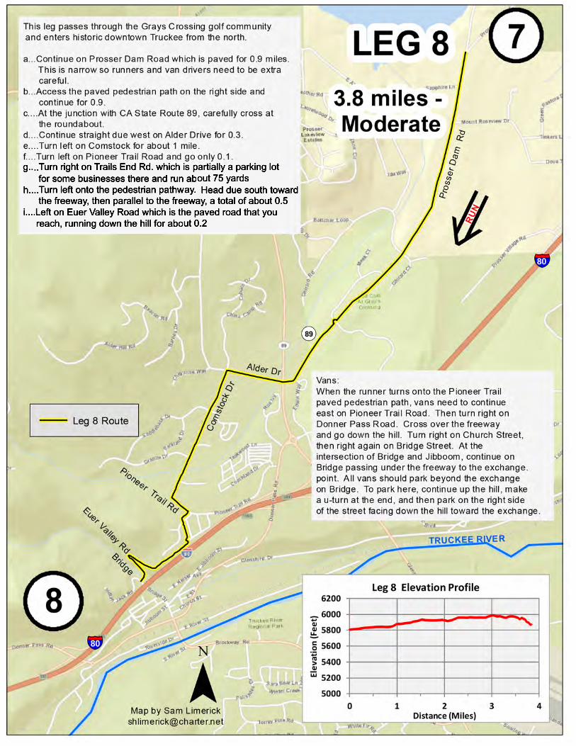
Vans: head due north on Hirschdale Road about 0.3 miles passingunder the freeway and then immediately enter Interstate 80 heading west for Truckee. Proceed almost 6 miles. Take the State Route 89 exit and turn right heading north toward Sierraville. Proceed north about 0.5 mile. Turn right at the second roundabout onto Prosser Dam Road. Drive less than 2 miles through the Grays Crossing golf community and beyond to Exchange Point No. 7 in the dirt pullout area on the left where the paved Prosser Dam Road ends. Please drive slowly on Prosser Dam Road and watch out for Leg 8 runners running at you on the narrow part of this street.
")787
")890
")890
Boca Dam RdhRUN
Leg 7 Route
Prosser
Dam Rd Hirschdale Rd
33

LEG 95.2 miles - Moderate
8
Map by Sam [email protected]
9
§̈¦80
¬«89
¯
TRUCKEE RIVER
Cabin Creek Rd
HIGHWAY 89
RUN
h
¬«89
Leg 9 Route
This leg exits Truckee and heads for Lake Tahoe.a. Left on Bridge St. passing under the freeway for 0.2 milesb. Right on Jibboom for 0.2 milesc. Left on Spring for less than 0.1 milesd. Right on Donner Pass Road for about 0.3. Runners must run on the sidewalk on the right side or westbound side of the road running WITH TRAFFIC.e. As y ou approach the roundabout, CROSS Donner Pass Road in the marked crosswalk. This crosswalk is just before y ou get to the roundabout.f. Stay on that sidewalk on the other side of Donner Pass Road heading west going around the roundabout. You will run about 30 yards. g. Left on McIver Crossing, the street that heads under the railroad tracks. h. IMMEDIATELY CROSS McIver Crossing in the marked crosswalk. So now the runner will be on the sidewalk on the other side of McIver. i. Run on the sidewalk only about 30 yards.j. V EER RIGHT onto the paved pathway that heads up the hill toward the Sierra College campus. k. Run due west on the paved pathway to the Sierra College campus. Continue due west through the parking lot. Then continue due west on the sidewalk adjacent to the entrance road into the Sierra College campus. This will be about 0.9 mi.l. Left at CA State Route 89 running on the sidewalk heading due south. You will pass through the pedestrian “mouse hole” that is the tunnel under the railroad tracks. Continue due south to the big intersection with West River St. The distance along this part of CA State Route 89 is 0.5 miles.m. At the big intersection, CROSS CA State Route 89 using the marked crosswalk. You MUST wait for the traffic signal to turn green.n. On the other side, turn left and run WITH TRAFFIC for about 3.0 miles. Stay as far away off the roadway as possible. Run on the dirt when y ou can. Do not cross over the white line separating the traffic lane.
Donner Pass RdJibboom
Bridge
McIverSpring
¬«89
NOTE TO V ANS:When y our runner heads up the pedestrian pathway away from McIver Crossing, continue dow n the hill on McIver. Turn right on West River Street and proceed to CA State Route 89. At that intersection, turn left on CA State Route 89. Plan to meet y our runner along CA State Route 89 south of the point.
PathSierra
CollegeCampus
35

36

LEG 115.3 miles - Moderate 10
Map by Sam [email protected]
11
¬«89
¯
Stamp
ede
Rese
rvoir
TRUCKEE RIVER
This leg reaches Tahoe City at Lake Tahoe. a.. Go back on Squaw Valley Road to Highway 89, running WITH traffic b.. ALERTLY cross the highway at the traffic signal and turn right on the other side, accessing the Truckee River Bike Path along the highway c.. Proceed along the Truckee River Bike Path to Tahoe City d.. Turn right and cross over the river using the pedestrian bridge e.. Stop at the exchange point in the Truckee River Bike Path parking lotVans: Drive on Highway 89 to Tahoe City. Turn right on Highway 89 (West Lake Blvd.) as it crosses "Fanny Bridge" over the Truckee Riverand heads south toward Homewood and South Lake Tahoe. Turn right into the Truckee River Pathway Parking Lot.
SQUAW VALLEY RDSquawValley Park
ALPINEMEADOWS
RD
FannyBridge
Truckee RiverPathway
Parking Lot
TahoeCity
6,0006,2006,4006,6006,8007,000
0 1 2 3 4 5 6
Elevat
ion (Fe
et)
Distance (Miles)
Leg 11 Elevation Profile
¬«89
Truckee River Bikepath
37

LEG 126.2 miles - Moderate
11
Map by Sam [email protected]
12
¬«89
¯
Stamp
ede
Rese
rvoir
This leg travels down the west shore of Lake Tahoe to Homewood. a.. Exit the Truckee River Bike Path parking lot b.. Turn right on West Lake Blvd (Highway 89) c.. Continue along West Lake Blvd (Highway 89) to Homewood, running WITH traffic either on the shoulder or using the bike path when it is on that side of the road d.. Stop at the exchange point at the parking lot for Homewood Ski Resort
FannyBridge
Truckee RiverPathway
Parking Lot
¬«89
HomewoodSki Resort
6000
6200
6400
6600
6800
7000
0 1 2 3 4 5 6 7
Eleva
tion (
Feet)
Distance (Miles)
Leg 12 Elevation Profile
38
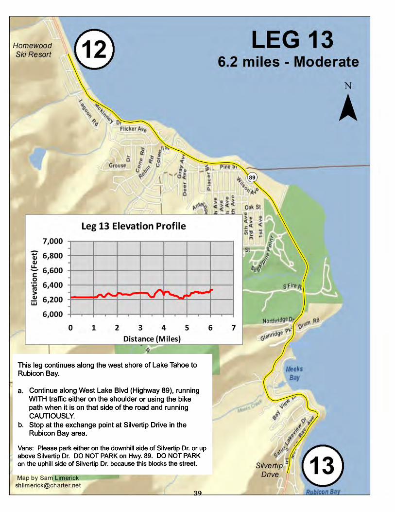
39

LEG 146.7 miles - Most Difficult
This leg continues along the west shore to Emerald Bay.
a.. Continue along Highway 89 climbing up and then dropping into the Emerald Bay area, running WITH traffic on the shoulder and running CAUTIOUSLY b.. Stop at the exchange point at the parking lot for the Eagle Falls Trailhead
¬«89
Silvertip Drive
Eagle FallsTrailheadParking
¯
13
14
6,0006,2006,4006,6006,8007,000
0 1 2 3 4 5 6 7Ele
vation
(Feet)
Distance (Miles)
Leg 14 Elevation Profile
Map by Sam [email protected]
40
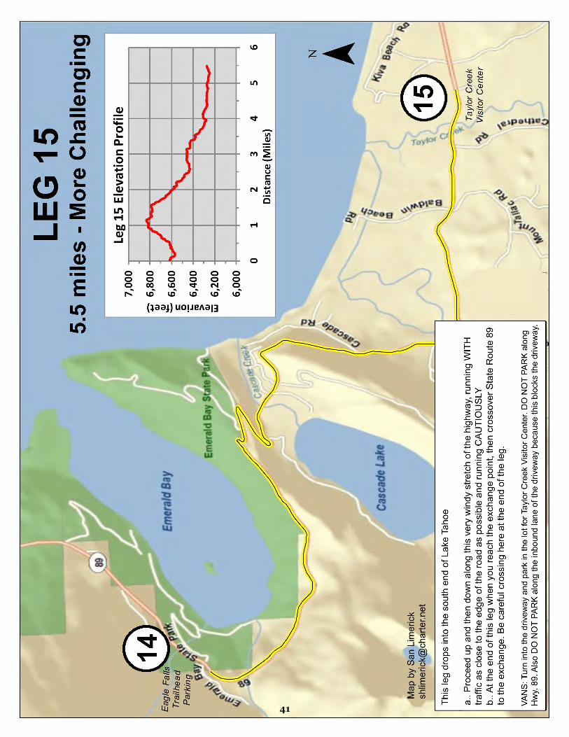
41

42
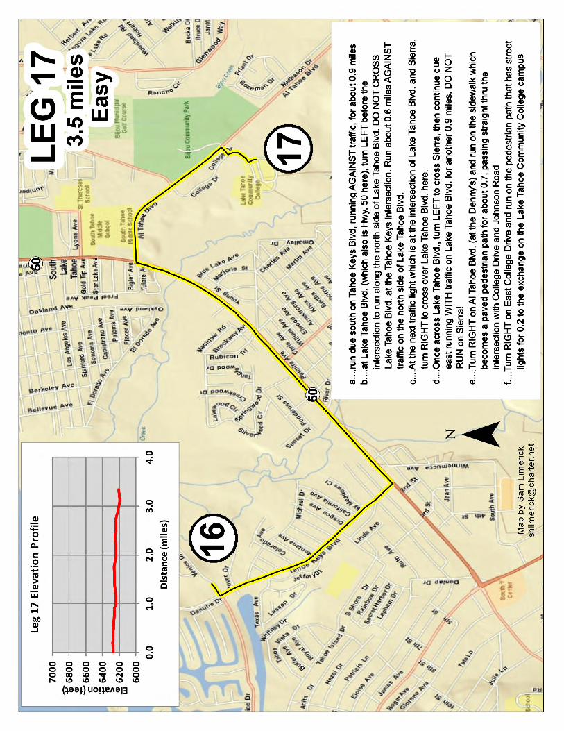
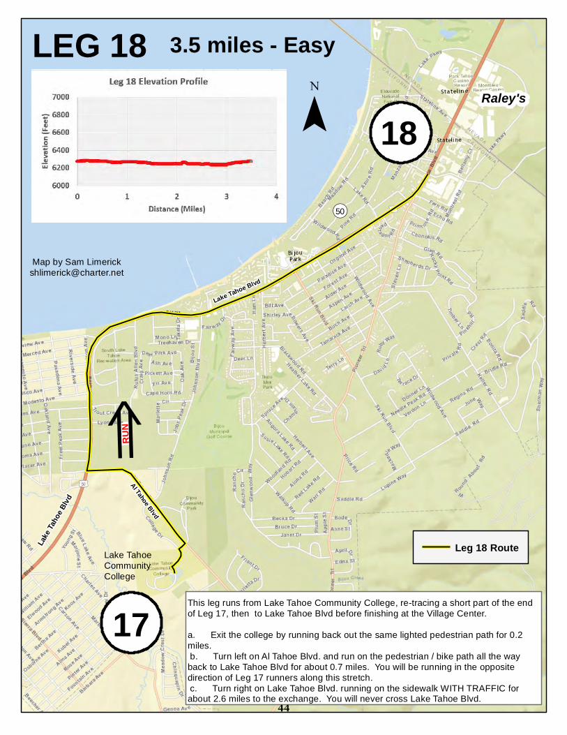
LEG 18 3.5 miles - EasyRaley's
¬«50
¯
Map by Sam [email protected]
17
18
This leg runs from Lake Tahoe Community College, re-tracing a short part of the end of Leg 17, then to Lake Tahoe Blvd before finishing at the Village Center. a. Exit the college by running back out the same lighted pedestrian path for 0.2 miles. b. Turn left on Al Tahoe Blvd. and run on the pedestrian / bike path all the way back to Lake Tahoe Blvd for about 0.7 miles. You will be running in the opposite direction of Leg 17 runners along this stretch. c. Turn right on Lake Tahoe Blvd. running on the sidewalk WITH TRAFFIC for about 2.6 miles to the exchange. You will never cross Lake Tahoe Blvd.
Lake
Taho
e Blvd
Lake Tahoe Blvd
Al Tahoe Blvd
Leg 18 Route
RUN
h
Lake TahoeCommunityCollege
44
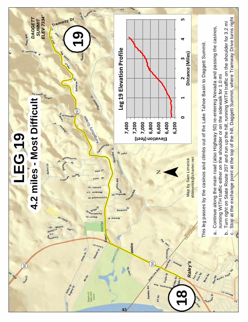
LEG
194.2
mile
s - M
ost D
ifficu
lt
¬ «50¬ «50
18¯
Map b
y Sam
Lime
rick
shlim
erick
@ch
arter.
net
19
Raley
's
DAGG
ETT
SUMM
ITEL
EV 73
34'
Kingsb
ury G
rade
Tramway Dr
¬ «207
6,200
6,400
6,600
6,800
7,000
7,200
7,400
01
23
45
Elevation (feet)Dis
tance
(Miles
)
Leg 19
Elevat
ion Pr
ofile
This
leg pa
sses
by th
e cas
inos a
nd cl
imbs
out o
f the L
ake T
ahoe
Basin
to D
agge
tt Sum
mit.
a.. C
ontin
ue al
ong t
he m
ain ro
ad (a
lso H
ighwa
y 50)
re-en
tering
Nev
ada a
nd pa
ssing
the c
asino
s,
run
ning W
ITH tra
ffic ei
ther o
n the
shou
lder o
r on t
he si
dewa
lk for
1.0 m
i b
.. Turn
right
on S
tate R
oute
207 a
nd ru
n up t
he hi
ll, run
ning W
ITH tra
ffic on
the s
hould
er for
3.2 m
i c
.. Stop
at th
e exc
hang
e poin
t at th
e top
of th
e hill,
Dagg
ett S
ummi
t, whe
re Tr
amwa
y Driv
e turn
s righ
t
45

LEG
204.3
mile
s - M
oder
ate
¬ «207
20
¯Ma
p by S
am Li
meric
ksh
limeri
ck@
chart
er.ne
t
19DAGG
ETT
SUMM
ITEL
EV 73
34'
Kings
bury
Grad
e
TramwayDrive
¬ «207
This
leg dr
ops h
alf w
ay do
wn th
e fam
ous K
ingsb
ury G
rade.
a.. C
ontin
ue al
ong S
tate R
oute
207,
head
ing do
wn th
e hill
and r
unnin
g WITH
traffic
on th
e sho
ulder,
and
stop
at th
e exc
hang
e poin
t in th
e pull
-out a
rea al
ongs
ide th
e roa
d
Pullo
utAr
ea5,5
006,0
006,5
007,0
007,5
00
01
23
45
Elevation (Feet)
Distan
ce (M
iles)
Leg 20
Elevat
ion Pr
ofile
46

47

LEG 225.8 miles - Moderate
¬«207
22
¯Map by Sam [email protected]
¬«206 This leg travels to historic Genoa, Nevada. a.. Turn left onto Foothill Road and proceed in a northerly direction, running AGAINST traffic using the shoulder, until you reach the exchange point at Mormon Station State Historic Park in the center of Genoa at the main intersection
4,0004,2004,4004,6004,8005,000
0 1 2 3 4 5 6
Elevat
ion (M
iles)
Distance (Miles)
Leg 22 Elevation Profile
21MOTTSVILLE LANE
GENOA LANE (RTE 206)
Mormon StationState Park
Genoa
48
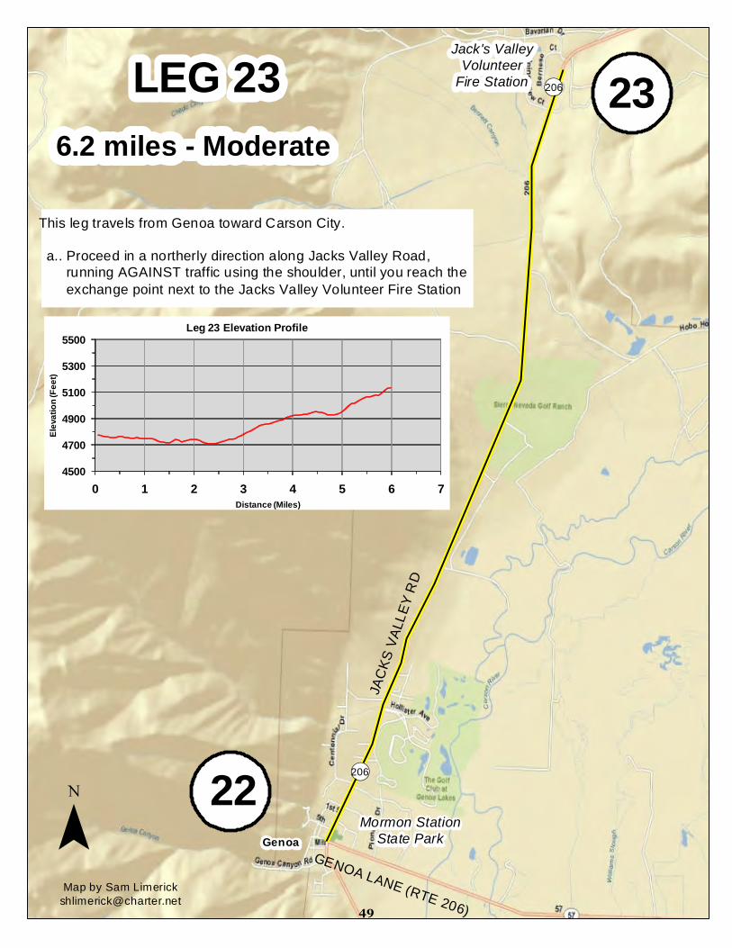
LEG 236.2 miles - Moderate
¬«206 23
M̄ap by Sam [email protected]
¬«206
This leg travels from Genoa toward Carson City. a.. Proceed in a northerly direction along Jacks Valley Road, running AGAINST traffic using the shoulder, until you reach the exchange point next to the Jacks Valley Volunteer Fire Station
22GENOA LANE (RTE 206)
Mormon StationState ParkGenoa
Jack's ValleyVolunteer
Fire Station
JACK
S VAL
LEY R
D
4500
4700
4900
5100
5300
5500
0 1 2 3 4 5 6 7
Eleva
tion (
Feet)
Distance (Miles)
Leg 23 Elevation Profile
49

LEG
243.3
mile
s - Ea
sy
£ ¤395
24
¯Ma
p by S
am Li
meric
ksh
limeri
ck@
chart
er.ne
t
¬ «206
23Ja
ck's
Valle
yVo
luntee
rFir
e Stat
ion
JACK
S VAL
LEY R
D
TOPS
Y LN
This
leg re
ache
s the
city
limits
of C
arson
City
, Nev
ada's
capit
al.a..
Con
tinue
alon
g Jac
ks V
alley
Roa
d, run
ning A
GAIN
ST tra
ffic on
the s
hould
er,
until
you r
each
High
way 3
95b..
Turn
left o
n High
way 3
95 an
d run
AGA
INST
traffic
on th
e sho
ulder
c.. A
t the n
ext li
ghted
inter
secti
on w
here
Highw
ay 39
5 cros
ses T
opsy
Lane
, AL
ERTL
Y cro
ss at
the t
raffic
sign
al an
d turn
left o
n the
othe
r side
of To
psy L
ane,
the
n run
WITH
traffic
the s
hort d
istan
ce to
the e
ntran
ce of
the W
al-Ma
rt park
ing lo
t an
d stop
at th
e exc
hang
e poin
t there
Wal-M
art
£ ¤50
4,800
5,000
5,200
5,400
5,600
5,800
01
23
4
Elevation (feet)
Distan
ce (M
iles)
Leg 24
Elevat
ion Pr
ofile
50
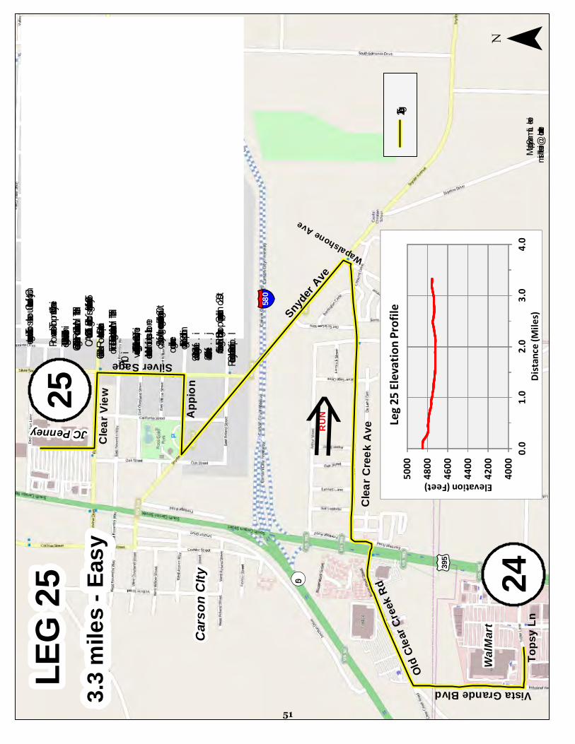
LEG
253.3
mile
s - E
asy
£¤395
¯Ma
p by S
am Li
meric
ksh
limeri
ck@
chart
er.ne
t
¬ «50
WalM
art
Tops
y Ln
24
25Vista Grande Blvd
Cars
on C
Ity
RUN
h
Leg 2
5Ol
d Clea
r Cree
k Rd
Clea
r Cree
k Ave
Snyder
Ave
Wapalshone Ave
Appio
n
Silver Sage
Clea
r View
JC Penney
§̈ ¦580
This
leg en
ters a
nd cu
ts ac
ross t
he so
uthern
end o
f Cars
on C
ity.
a.. P
rocee
d wes
t on T
opsy
Lane
for 0
.1 mi
b.. Tu
rn rig
ht on
Vist
a Gran
de B
lvd an
d run
0.3 m
i.c..
Turn
right
on O
ld Cl
ear C
reek R
oad a
nd ru
n WITH
traffic
for 0
.4 d..
CAU
TIOUS
LY cr
oss H
ighwa
y 395
at th
e traf
fic si
gnal
at the
Old
C
lear C
reek R
oad –
Lupin
Driv
e inte
rsecti
one..
Turn
left o
n Fron
tage R
oad a
nd ru
n WITH
traffic
for le
ss th
an
0
.1 mi
f...Tu
rn rig
ht on
Clea
r Cree
k Ave
. and
run 0
.8 mi
, inclu
ding a
very
sh
ort bi
t at th
e end
on W
apals
hone
g..Le
ft on S
nyde
r Ave
nue a
nd ru
n abo
ut 0.6
inclu
ding c
rossin
g
over
the br
idge
h...R
ight o
n App
ion fo
r 0.2
i..Left
on Si
lver S
age f
or 0.3
j...Le
ft on C
learvi
ew fo
r 0.2
k....R
ight in
to the
South
gate
Shop
ping C
enter
and r
un al
most
0.2l...
Stop i
n fron
t of th
e J.C
. Pen
ney
4000
4200
4400
4600
4800
5000
0.01.0
2.03.0
4.0
Elevation (Feet)
Distan
ce (M
iles)
Leg 25
Elevat
ion Pr
ofile
51
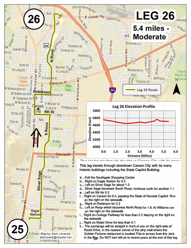
52

53

54

LEG 293.4 miles - More Challenging
¯Map by Sam Limerick
This leg passes through Silver City and Devils Gate. a.. Proceed to the end of Industrial Parkway b.. Turn left on State Route 341 a.k.a. the Comstock Highway, running AGAINST traffic on the shoulder and running CAUTIOUSLY c.. Veer left on State Route 342, running AGAINST traffic and running CAUTIOUSLY d.. Continue through Silver City and Devil’s Gate before CAREFULLY crossing the road and stopping at the exchange point just on the other side of Devil's Gate
29
28
UV341
INDUSTRIAL
Custom Coatings
Parking Lot
SilverCity
UV342
Devil'sGate
4600
4800
5000
5200
5400
5600
0 1 2 3 4
Eleva
tion (
Feet)
Distance (Miles)
Leg 29 Elevation Profile
55
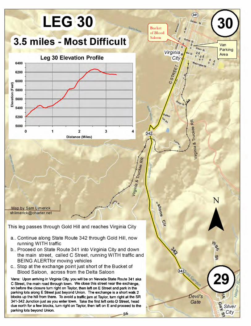
56

LEG 313.1 miles - Most Difficult
M̄ap by Sam [email protected]
30
31
UV341
UV341
VirginiaCity
Bucket of Blood Saloon
LOUS
ETOW
N RD
This leg exits Virginia City and starts the return to Reno. a..Exit Virginia City on the main street which becomes State Route 341, running WITH traffic and running CAUTIOUSLY b.. Turn right on Lousetown Road c.. Stop at the exchange point just down the roadVans: Proceed along D Street until it veers right and merges with C Street which becomes State Route 341.
5600
5800
6000
6200
6400
6600
0 1 2 3
Eleva
tion (
Feet)
Distance (Miles)
Leg 31 Elevation Profile
57

58

LEG
336.6
mile
s - M
ore C
halle
nging
¯Ma
p by S
am Li
meric
ksh
limeri
ck@
chart
er.ne
t
Toll R
oadGe
iger
Summ
it
33
Vans
: Driv
e dow
n the
Geig
er G
rade
High
way a
ka N
evad
a Stat
e Rou
te34
1 for
6.5 m
iles.
Turn
left o
n Kive
tt and
drive
0.7 m
iles.
You m
ay tu
rnlef
t on T
oll R
oad a
nd pr
ocee
d alm
ost 1
mile
to a
dirt p
ullou
t are
a on
the r
ight.
That
is the
furth
est p
oint y
ou m
ay dr
ive on
Toll R
oad t
o wait
for
your
runn
er.
This
leg de
scen
ds th
e orig
inal G
eiger
Grad
e befo
re en
ding i
n sou
th Re
no.
a.
Run
back
0.2 t
o the
inter
secti
on w
ith C
artwr
ight R
oad,
then C
AREF
ULLY
cros
s the
high
way.
b. R
un du
e wes
t on t
he di
rt port
ion of
Toll R
oad (
actua
lly Tr
ojan R
d. on
the m
ap) a
cross
the f
lat
mead
ow, th
en fo
llow
the ro
ad do
wn th
e can
yon f
or 3.7
mile
s. M
ost o
f the d
irt roa
d is n
ewly
grade
d an
d gen
tly sl
oped
. The
re are
a co
uple
steep
and r
ock s
ectio
ns, s
o be c
areful
desc
endin
g tho
se
portio
ns. R
EMSA
will
be at
the b
ottom
if yo
u nee
d a lit
tle fir
st aid
.c.
As y
ou re
ach t
he bo
ttom
and e
xit th
e can
yon,
conti
nue d
ue w
est o
n the
sing
le lan
e pav
ed ro
ad
for 0.
5 mile
s.d.
Con
tinue
on th
e two
lane
d pav
ed po
rtion o
f Toll
Roa
d for
1.9 m
iles.
There
is a
pave
d ped
estria
n pa
th on
the l
eft si
de of
the r
oad.
e.
At th
e inte
rsecti
on w
ith S
tate R
oute
341 t
here
is a t
raffic
light
and c
rossw
alk. C
ross t
here
when
the
light
is gre
en.
f. Co
ntinu
e stra
ight th
rough
the i
nterse
ction
onto
Eque
strian
Roa
d for
0.3 m
iles.
g.
Vee
r righ
t and
merg
e onto
Wes
tern S
kies D
rive a
nd co
ntinu
e on t
he ro
ad fo
r 0.4
miles
.h.
Stop
at th
e exc
hang
e at th
e inte
rsecti
on of
Wes
tern S
kies D
rive a
nd R
eadin
g not
far fro
m Br
own
Eleme
ntary
Scho
ol.
RUN
hLe
g 33 R
oute
4500
5000
5500
6000
6500
01
23
45
67
Elevation (feet)Dis
tance
(Mile
s)
Leg 33
Elevat
ion Pr
ofile
32Tro
jan R
d
UV341
UV341
59

60

LEG
356.2
mile
s - M
oder
ate
This
leg tra
vels
throu
gh S
outh
Reno
.a.
Conti
nue n
orth o
n Dou
ble D
iamon
d Park
way r
unnin
g WITH
tra
ffic fo
r 0.8
miles
b. Ri
ght o
n Dou
ble R
Blvd
., cros
sing t
he in
terse
ction
there
and
run
ning A
GAIN
ST tra
ffic fo
r 1.4
mic.
Left o
n Lon
gley a
nd ru
n AGA
INST
traffic
for a
bout
1.0 m
i to
So
uth V
irgini
a Stre
etd.
At tha
t bus
y inte
rsecti
on, C
AREF
ULLY
CRO
SS; L
ongle
y
beco
mes H
uffak
er La
ne
e. Co
ntinu
e stra
ight ru
nning
due w
est o
n Huff
aker
for ab
out
1.5
mi to
the e
ndf. R
ight o
n Lak
eside
, cros
sing t
he in
terse
ction
there
and r
unnin
g
AGAIN
ST tra
ffic up
, arou
nd, a
nd do
wn W
indy H
ill for
abou
t 1.3
mig.
Righ
t on B
artley
Ran
ch R
oad,
CARE
FULL
Y CRO
SSIN
G
Lake
side u
sing t
he cr
ossw
alk an
d run
ning a
bout
0.1 m
ih.
Left o
n Whe
atlan
d for
abou
t 0.1
mi to
the e
xcha
nge i
n fron
t of
Hu
ffake
r Elem
entar
y Sch
ool
S. Virginia
Lakeside Dr
Longley Ln
Double R
DDAC
nHu
ffake
r Sch
ool
¯
35
34
Mead
ow-
wood
Mall
Febru
ary 19
, 201
1Ma
p by S
am Li
meric
ksh
limeri
ck@
chart
er.ne
t
4,000
4,200
4,400
4,600
4,800
5,000
01
23
45
67
Elevation (feet)
Distan
ce (M
iles)
Leg 35
Elevat
ion Pr
ofile
61
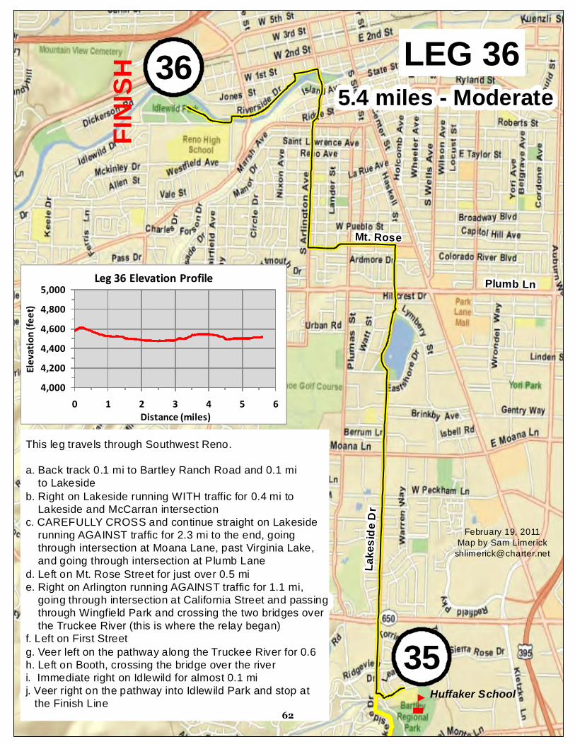
LEG 365.4 miles - Moderate
This leg travels through Southwest Reno.a. Back track 0.1 mi to Bartley Ranch Road and 0.1 mi to Lakesideb. Right on Lakeside running WITH traffic for 0.4 mi to Lakeside and McCarran intersection c. CAREFULLY CROSS and continue straight on Lakeside running AGAINST traffic for 2.3 mi to the end, going through intersection at Moana Lane, past Virginia Lake, and going through intersection at Plumb Laned. Left on Mt. Rose Street for just over 0.5 mi e. Right on Arlington running AGAINST traffic for 1.1 mi, going through intersection at California Street and passing through Wingfield Park and crossing the two bridges over the Truckee River (this is where the relay began)f. Left on First Streetg. Veer left on the pathway along the Truckee River for 0.6h. Left on Booth, crossing the bridge over the river i. Immediate right on Idlewild for almost 0.1 mi j. Veer right on the pathway into Idlewild Park and stop at the Finish Line
Mt. Rose
Lake
side D
r
nHuffaker School
FINIS
H
35
36
4,0004,2004,4004,6004,8005,000
0 1 2 3 4 5 6
Elevat
ion (fe
et)
Distance (miles)
Leg 36 Elevation Profile Plumb Ln
February 19, 2011Map by Sam Limerick
62

Driving Instructions For The “Resting Van” aka the Vehicle With The Runners Who Are Not Running That Group of 6 Legs To reduce the chance of traffic congestion on certain parts of the relay course, the vehicle that is transporting the runners who are sitting out the group of 6 legs and not running them (aka The Resting van as compared to The Running Van, terms we borrow from our friend Jeff Shapiro the race director of The Relay) must follow these driving directions. Legs 1-6 Van 2 will be the vehicle with runners sitting out these legs. Do not travel along the relay course through southwest Reno and Verdi and later along Stampede Dam/Meadows Road. Rather, you should leave the Wingfield Park start area by traveling west on W. First Street. Turn right on Keystone Avenue and travel north to Interstate 80. Enter Interstate 80 westbound toward Sacramento and travel on the freeway 23 miles. Take the Hirschdale Road exit (Exit No. 194). At the stop sign, turn right and drive under the freeway much less than a mile to the Tahoe Forest Church at 10315 Hirschdale Road. Exchange Point No. 6 will be on your left. Pass the exchange and enter the church property where there will be plenty of parking and fun stuff too. For those of you using a navigational device, the address for the Tahoe Forest Church is 10315 Hirschdale Road, Truckee, California. Legs 7-12 Van 1 will be the vehicle with resting runners. Head back due north to Interstate 80. Enter Interstate 80 heading west to Truckee and use the freeway to travel west to Truckee just a few miles to the west. To see historic Downtown Truckee, use the Central Truckee exit (Exit No. 186) and turn left on Donner Pass Road. The main commercial district is just a mile or so down the road. Or to head directly to Lake Tahoe, continue on I-80 to the next exit for Highway 89 South and Lake Tahoe (Exit No. 185). Turn left onto Highway 89 and proceed south approximately 13 miles to Tahoe City. As you enter Tahoe City, turn right at the first junction, crossing where the Truckee River originates at Lake Tahoe (that bridge is known as “Fanny Bridge” because of all of the people bending over looking at the fish) and continuing south down Highway 89 about 6 miles to the vehicle exchange point at Homewood Mountain Resort. The address for Homewood Mountain Resort where Exchange No. 12 is located is 5145 Westlake Blvd (aka CA State Route 89), Homewood, California. Legs 13-18 Van 2 is the vehicle with resting runners. You have no option here but to travel the relay course south down Highway 89 to get to South Lake Tahoe. At the “Y” intersection with Highway 50 - Lake Tahoe Blvd, turn left and proceed to the Village Center just short of Stateline. That is the location of the mid-point of the relay course and the next vehicle exchange point. The address of the Starbucks at the Village Center is 4000 Lake Tahoe Blvd., South Lake Tahoe, California. Please do not drive in excess of the speed limit as you travel south on Highway 89. You will be passing your teammates and other runners. Show them lots of consideration.
63
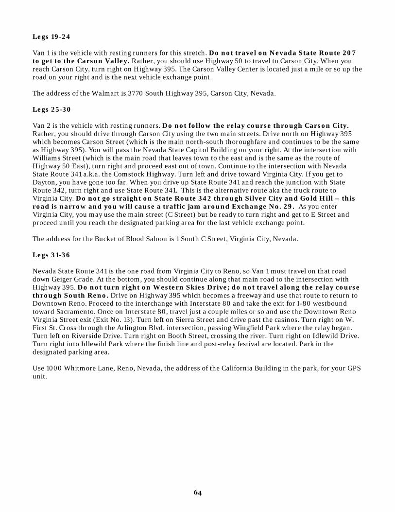
Legs 19-24 Van 1 is the vehicle with resting runners for this stretch. Do not travel on Nevada State Route 207 to get to the Carson Valley. Rather, you should use Highway 50 to travel to Carson City. When you reach Carson City, turn right on Highway 395. The Carson Valley Center is located just a mile or so up the road on your right and is the next vehicle exchange point. The address of the Walmart is 3770 South Highway 395, Carson City, Nevada. Legs 25-30 Van 2 is the vehicle with resting runners. Do not follow the relay course through Carson City. Rather, you should drive through Carson City using the two main streets. Drive north on Highway 395 which becomes Carson Street (which is the main north-south thoroughfare and continues to be the same as Highway 395). You will pass the Nevada State Capitol Building on your right. At the intersection with Williams Street (which is the main road that leaves town to the east and is the same as the route of Highway 50 East), turn right and proceed east out of town. Continue to the intersection with Nevada State Route 341 a.k.a. the Comstock Highway. Turn left and drive toward Virginia City. If you get to Dayton, you have gone too far. When you drive up State Route 341 and reach the junction with State Route 342, turn right and use State Route 341. This is the alternative route aka the truck route to Virginia City. Do not go straight on State Route 342 through Silver City and Gold Hill – this road is narrow and you will cause a traffic jam around Exchange No. 29. As you enter Virginia City, you may use the main street (C Street) but be ready to turn right and get to E Street and proceed until you reach the designated parking area for the last vehicle exchange point. The address for the Bucket of Blood Saloon is 1 South C Street, Virginia City, Nevada. Legs 31-36 Nevada State Route 341 is the one road from Virginia City to Reno, so Van 1 must travel on that road down Geiger Grade. At the bottom, you should continue along that main road to the intersection with Highway 395. Do not turn right on Western Skies Drive; do not travel along the relay course through South Reno. Drive on Highway 395 which becomes a freeway and use that route to return to Downtown Reno. Proceed to the interchange with Interstate 80 and take the exit for I-80 westbound toward Sacramento. Once on Interstate 80, travel just a couple miles or so and use the Downtown Reno Virginia Street exit (Exit No. 13). Turn left on Sierra Street and drive past the casinos. Turn right on W. First St. Cross through the Arlington Blvd. intersection, passing Wingfield Park where the relay began. Turn left on Riverside Drive. Turn right on Booth Street, crossing the river. Turn right on Idlewild Drive. Turn right into Idlewild Park where the finish line and post-relay festival are located. Park in the designated parking area. Use 1000 Whitmore Lane, Reno, Nevada, the address of the California Building in the park, for your GPS unit.
64

Staying on the Course We will post directional signs and/or use arrows on the roadway to guide you through parts of the course where it may be easy to get off track. A nice feature of this course is that most of the legs are straightaways down the main road. We will not, however, be able to put a sign at every turn of the 178 mile course. And you may not see it anyway, due to traffic or lighting conditions or your lightning quick running speed. So please study the maps before you run each leg. And have your van mates be parked near each turn to make sure you do not get off course. Here are some lessons learned from prior RTOs: Leg 2: 1) In Mogul stay on the frontage road parallel to the freeway. DO NOT TURN RIGHT into the residential neighborhoods. You’ll just run more miles. And make your teammates mad for the slower-than-necessary start. Plus this is where the recent swarm of earthquakes has been. More reason to say on course and get through here quickly. 2) TURN LEFT onto the Tahoe-Pyramid Bikeway path that is parallel to the freeway. This takes you directly to Verdi and the end of this leg. Failing to turn off onto the path leads to running more miles. And teammates who are more angry. Leg 4 When you reach Summit 1 aka the False Summit and you come to the junction there, VEER LEFT. There is a big sign that says left to Stampede Reservoir and right to a bunch of other nice places but none that you want to visit during the RTO! DO NOT veer right! Leg 7 Once you cross the Boca Dam, just run straight. DO NOT ever take a right. There will be two junctions where there are road signs. Both times take the option TO THE LEFT. The road signs state that the left turns are to Prosser Reservoir and CA State Route 89. That is exactly where you should be heading to get to the end of Leg 7. Leg 8 There is one turn that many runners always miss. It is the right turn off of Pioneer Trail onto the pedestrian pathway. We put a sign there to help you find this turn onto the path. This year we might add balloons and a person dressed in a gorilla suit but don’t count on that. If you reach the Full Belly Deli at 10825 Pioneer Trail, you have run too far and missed the turn! Leg 9 This roundabout on Donner Pass Road is one of the trickiest parts of the course every year. Runners and vans need to get off of Donner Pass Road and turn left onto the street called McIver Crossing, which heads down the hill and under the railroad tracks to connect to West River Street. If you continue straight on Donner Pass Road, through the roundabout, you will have gone the wrong way, way too far west. Runners need to veer right onto the pedestrian trail that leaves McIver Crossing and heads up and across the Sierra College Truckee campus. On the west side of Truckee, runners will reach Highway 89 and need to turn left. Vans will use West River Street to get to Highway 89 and then turn left. No one should turn right on Highway 89.
65

Leg 11 At the end of this leg as the runner approaches Tahoe City, the runner takes a hard right onto the pathway bridge over the Truckee River. There should be a sign and a volunteer there to direct you. But regardless be ready to make the hard right turn crossing the river on the footbridge. The exchange is on the other side of the bridge on the pathway area adjacent to the parking lot for the Truckee River Pathway. The runner SHOULD NOT continue along north side of the bridge and cross the river on Fanny Bridge. Van 2 drivers: At the end of this leg as you enter Tahoe City, continue to the first lighted intersection. Turn right following CA State Route 89 south toward Homewood. You will cross the Truckee River on what we locals call “Fanny Bridge.” Drive past the Bridgetender restaurant on your right. Continue a few hundred yards and turn right into the Truckee River Bike Path parking lot. The exchange is at the north end of the parking lot. Leg 16 Leg 16 turns off Highway 89 before you get to the huge intersection with the traffic light known as the “Y.” So if you reach this intersection, you have gone too far. Go back and turn toward the Lake and Tahoe Keys! Leg 22 This leg starts at the intersection at the bottom of Kingsbury Grade. The runner has 3 choices. 2 are wrong. Please head north on Foothill Road, toward Genoa. In other words, TURN LEFT here. DO NOT go straight or right. Wrong Way Joe Dito once turned right and was lost for a long time. Do not repeat that history. Leg 24 At Highway 395 just south of Carson City, turn left. DO NOT TURN RIGHT and head toward Gardnerville or Minden. Leg 28 Two things about Highway 50 other than be careful on this busy road. One, cross this busy road at the start when you first reach it, then turn right on the other side and run against traffic up the hill. This is the only place to cross the road at an intersection. Two, be sure to turn left off Highway 50 onto Affonso Drive. If you reach the junction with Highway 341, you have gone too far. If you pass that and get to Dayton, you have REALLY gone too far. Ask Paul Cooney about that. Adds a lot of miles and pisses off / scares your teammates. NOTE: Camp Richardson at South Lake Tahoe is not part of the relay In 2006 we had runners go into Camp Richardson and demand to use the showers. We do not have an arrangement with Camp Richardson. So unless you have a room or campsite there, please do not stop there. Thank you.
66

Relay Basic Guidelines The course is divided into 36 legs. At the end of each leg is a runner exchange area. That is where one runner ends and the next runner begins. Runners will carry a team slap band and pass that to each other at the exchange points. The slap band takes the place of a baton. Teams with 12 runners run in order through their line-up one through 12 to complete the relay course. After running the first 12 legs, the runners repeat this process and run the second and third groups of 12 legs. Each runner should run 3 legs of the 36 leg course. Let’s focus on the vehicles for a moment. Each team has two vehicles, with 6 runners in each vehicle. The first vehicle with 6 runners will cover the first 6 legs. The second vehicle with the other 6 runners will cover the next 6 legs. The vehicles will leapfrog along the course alternating covering each group of 6 legs until the team finishes the course. Accordingly, the runners in the first team vehicle will cover Legs 1-6, 13-18, and 25-30. Let’s call that vehicle “Van 1.” The runners in the second team vehicle will cover Legs 7-12, 19-24, and 31-36. Let’s call that vehicle “Van 2.” At the end of each group of 6 legs is a vehicle exchange area. That is where one group of 6 runners completes running the prior 6 legs and the team’s other runners begin to run the next group of 6 legs. Part of the challenge of a relay like this one is to estimate how long it will take each runner to run his or her leg. Teams need to be at the next runner exchange point when the runner arrives there. In addition, the one team vehicle needs to be at the vehicle exchange point when the other team vehicle arrives there that is carrying the runners who ran the prior six legs. Each team must provide its own supplies to support its runners. Plan to leave room in your team vehicles for these supplies. Do not plan on any aid stations along the course. Tips To Having A Great Time During The Relay Designate a captain for your team who is a take charge personality and enjoys working with details. Train for this event. Be ready to go physically and mentally. Be very familiar with the parts of the course that you are running. To make sure you stay on course, have your team van and van mates hang around in a safe parking location near every turn so they can see that the runner made the correct turn. In addition, while running your leg, carry a copy of the map of your leg and your cell phone to give you an extra sense of security. Always be cautious and alert and safe. Wear your safety vest all the time. When running your legs, be properly hydrated. Carry your own water or sports drink. Don’t rely on your team to hydrate you as you run your leg. It may be too late. The running van should closely monitor the runners on Legs 34, 35 and 36. It can be VERY WARM on Saturday when the runners are on these last 3 legs. Stay close enough to them to make sure the runner has enough water for the entirety of these legs. Stretch after you run each of your legs. Don’t run a set of legs that are rated “Most Difficult” or “More Challenging” unless you are a more experienced or talented runner. Don’t be assigned to a slot in the runner line-up that you don’t think you can handle.
67

The runners who are assigned to run the steeper climbs, especially the uphill parts of the “Most Difficult” legs, should feel free to “power walk” those parts. That is, they should get in a crouch position and take long strides to get up those hills. This is a tactic used by ultra runners who face steep climbs during their ultra runs. Trying to run the climbs will only deplete you of energy. Don’t let your pride get in the way of your completing the leg in the most effective manner. Don’t run Leg 4 unless you are a strong runner. Don’t run Leg 33 unless you like descending steep dirt roads with loose rocks intermittently thrown in. Runners in Van 2 may want to reserve a room(s) in South Lake Tahoe for Friday night. After finishing Legs 7-12, the runners in Van 2 should drive straight to South Lake Tahoe, check into their room(s), and get a quick nap and/or a shower. NOTE: The faster your team runs, the less time you will have to pull this off. You may have no option but to “rough it.” The runners in Van 1 may want to reserve a room(s) in Carson City for Friday night. After completing Legs 13-18, the runners in Van 1 should drive straight to Carson City, check into their room(s), and get a quick nap and/or a shower. NOTE: The faster your team runs, the less time you will have to pull this off. You may have no option but to “rough it.” Reno-Tahoe Odyssey and Capital Odyssey Relay runners may want to get a room at the Silverland Hotel in Virginia City to use for team naps and showers. Get to the runner and van exchange points far enough in advance of the approaching runner so that you can park the team vehicle in a safe manner and let the next runner have a time to get ready to go. When your running van finishes your set of legs, always drive forward along the course, ideally all the way to a location in close proximity to the next van exchange point. Do not drive backwards on the course. Do not hang out for a long time at the exchange where you finished your legs. Driving backwards or hanging out too long at that location will make it more difficult for your van to get to the next van exchange point where your van will be running legs again. Carry extra running gear such as socks and shirts if you tend to sweat a lot. Get to know the other teams. Your experience will be more rewarding if you create friendships with the other teams and cheer on each other as you travel the course. Enjoy the time with your teammates. Appreciate the fact that you are able to be participating in this event. Look out at the vistas. Suck up the fresh air. Gaze up at the stars. Have a blast! Finish as a team. There will be enough time for both Van 1 and Van 2 to drive to the finish area and park. The rest of your team should be standing at the start of Idlewild Park ready to escort the runner in the No. 12 spot to the finish line. Smile for the team photo after your team has completed the relay. Last but not least: implement a "No Whining" Rule for your team. This is a 178 mile adventure relay run that takes 24 hours give pr take a few hours depending on your team. This is not a quick and easy 5K in a park. One team’s name is spot on: Suck It Up Buttercup!
68

Checklist Below is a checklist of items your team should have on the relay course. Runners Handbook 12 runners (if you only want to run 3 legs :) ) 2 vehicles, neither one longer than 20 feet minimum of one reflective vest and one working flashlight per vehicle extra batteries for the flashlights blinking runner lights one safety sign per vehicle (we’ll give you this) tape for the sign supplies such as water, sports drinks, fruit, bagels and energy bars water bottle(s) for the Leg 4, 7 and 33 runners to carry cell phones and chargers for the car and plugging in at your motel room list of cell phone numbers of each of the team members, one per vehicle garbage bags safety pins for running bibs sunscreen toilet paper deodorant a fresh shirt and pair of socks for each of your runs plastic bags to put your sweaty clothes in handy wipes some type of watch to keep track of team’s time clipboard pens pillows and blankets aspirin basic first aid kit maps cash credit card spirit of adventure good attitude (remember, No Whining!)
69

Seventeen Tips for Having a Successful RTO Ultra EJ Maldonado from Carson City, a veteran RTO runner, was kind enough to present at one of the RTO Relay 101s his advice about how to get ready for and how to run the RTO with a six runner ultra team. He actually prepared a document with 17 tips. This is that document with EJ’s tips. Good luck to all of the ultra teams! 1. Eat REAL food!!! This is important!! When you shop, don’t just shop for snacking foods. You need to shop for real meals made of real food. There may be times where your stomach is blah, but you need to eat a balance of proteins, carbs, and fats to put back what you burn, refuel, and recover all at the same time. Best to find out what you can stomach during your training period and then do at the race. 2. Snack foods… These are important too for the times you need something in the belly… I recommend Lenny and Larry’s Complete Cookies, Nature’s Bakery Fig Bars, homemade bars, bagels and peanut butter, etc. 3. Coffee… Whether it’s straight coffee or one with frills, have some the morning of the race… it’s also good to have some double shots on ice ready to go too! 4. Sleep… take advantage of the fact that you are all in one van… there is no need to coordinate times to be at exchanges and such… I recommend at least two little naps during the RTO. 5. Bring a change of clothes… check that, bring multiple changes of clothes… I recommend bringing multiple changes of running clothes. Even if you stink, clean and fresh running clothes are a breath of fresh air… for everyone! I also recommend bringing a change of comfy clothes too. Be prepared for hot as hell and cold as ice! 6. Mints! I’m a huge believer in mints… Breath Savers, etc. Pop one of these in your mouth at the start of each leg, and you feel like you’re in one of those minty commercials. Clean mouth, clear mind! 7. Tums, Alka Seltzer… These go without saying… tummy troubleshooter! 8. Body Glide… Yep, for all the nooks, crannies, creases, folds, and chafing areas! 9. Perrier and Coca-Cola… Nothing is better than bubbly on the tummy! 10. M&Ms, Reese’s PB Cups, Snickers… these are great foods to have on hand for quick carbs (Fuel!) and some calories! 11. Try to secure a safe house along the route… if possible, try to stop at a team member’s home or a friend’s home during the RTO. A quick shower means a bunch to the body and the soul. 12. Plan at least one double day run and one 8 – 10 mile LSD run per week during your training starting now… the double day run can be splitting up a 5 – 6 mile run into 3 miles in the morning and 2 – 3 miles after work… or 2 miles and 2 miles. This gets your body used to running at different times of the day and multiple times per day. The 8 – 10 mile run is just good to get time on the road/trail at a slower pace. No need to break speed records. Another tip… plan a team group run in the middle of the night on one of the legs. 13. Run Trails… and HILLS!! Even if you aren’t accustomed to the trail, I highly advise turning at least one of your runs to the trail per week because trails are easier on the limbs, all about climbing, and more Zen. Did I mention hills?? Plan at least one run per week that includes hills. If you’re feeling frisky, do some hill repeats every few weeks. When you’re killin’ Kingsbury or Dog Valley, you’ll be glad you did!
70

14. Don’t be traditional… Be Creative! When planning on who’s doing what legs, you don’t have to attack it in a traditional manner. Since most of us aren’t gunning to win the whole thing, see if there are creative ways to split up the legs that point to a runner’s strengths. Some teams go two legs at a time. Some teams alternate legs one after the other. We are going to find specific legs we want to do this year and tailor our rotation around that. 15. Don’t take yourself so serious… It’s the RTO! It’s supposed to be fun. Don’t stress about pace, overall times, possibly disappointing your teammates, disappointing yourself, or any of that other stuff that goes with stressing yourself out. Breathe, have fun, and run 16. Don’t forget it’s a team thing… Fatigue, injuries, grumpiness, hunger, delirium… It’s all part of the ultra-experience! Make sure to be there to pick each other up, lighten the mood, and cheer on! If a teammate is injured or fatigue starts setting in, have a plan how to split up legs. Remember, you can split up a leg between two or more runners if needed. 17. Have fun, decorate the van, blast music (except in Genoa), and laugh often!
71
Time Adjustments and Penalties Teams that are too far ahead of or fall too far behind may be disqualified or asked to stop. Teams may be asked to stop at an exchange point for a period of time if they are ahead of their projected times or for other reasons. If you are asked to stop, please track your stopped time from the time you get to the exchange point until the time you are authorized to continue. Confirm this stop time with relay officials and the exchange point volunteers at that exchange point where you stopped. We will subtract the stop time to determine your total time. If you are running fast or ahead of our volunteers, expect to be stopped and held for a TBD period of time at Exchange No. 18 and/or No. 24. We’ll hold all teams at No. 18 until 10:30 pm. We’ll hold all teams at No. 24 until 2:30 a.m. If you think you will get to either of these locations before these points in time, please contact Eric Lerude about adjusting your start time. Team that fall behind their projected times or who fall outside of the time windows for the exchange points when volunteers are assigned to work at those locations may be asked to drive one or more legs to catch up with other teams in the field. We will determine your average minute per mile pace based on the legs you completed and than add that pace per mile to those legs that you drive instead of run. We will determine your total time using this method. Relay officials are the final authority to determine the winners of the divisions. Their decision stands. Teams that are disqualified may not receive their medals at the finish line and they may not be listed in the official results. Relay officials reserve the right to impose other penalties.
72
Rules for Competitive Teams Trying to Win Their Division Or Maybe The Whole RTO Please note that this event is not set up to be a true competition. We cannot guarantee uniformity in all the conditions that each team will encounter. Teams run at different times of the day and night. Teams encounter different challenges, such as different weather conditions at different parts of the course, and different length stops for trains and/or long red lights and/or unexpected wildlife encounters. Some teams may not even run the exact same course, but they may run a slightly different course. They run on one side of the street instead of the other side. They run extra miles when a runner gets lost. They may run fewer miles when a runner cuts a corner or block or mile accidently or maybe even on purpose. We cannot police every mile of a 178 mile course to make sure everyone runs the exact same course. To try to bring some order to the competition, competitive teams must adhere to the following rules. Teams must run in the order of their line-up. For example, for a 12 person team, they will run through the line-up in order 3 times: 1 through 12, then 1 through 12, then 1 through 12. If a team has only 11 runners, then they must run through their order 3 times. The first three runners in the line-up will need to run the last 3 legs in the same order. In other words, runner no. 1 will run Leg 34, runner no. 2 will run Leg 35, and runner no. 3 will run Leg 36. Teams cannot change or otherwise manipulate the order and still be eligible to claim first place. Once they do that, they are no longer eligible to win. There is one exception: if there is a legitimate injury to one runner. If someone either is unable to begin his or her leg or is unable to complete his or her leg, the team may select a substitute runner from the roster to run that leg and any other legs that that runner was supposed to run. The injured runner is disqualified from running in the rest of the event. No dropping out then coming back in. The same teammate cannot substitute more than once. Hence, if 3 legs must be run by substitute runners, 3 different runners must run one leg each. In addition, 10 minutes will be added for every substitution. For example, if a runner was injured during his or her first leg (but he or she completed the leg) and was unable to run the next two, the team would be penalized 20 minutes. If a runner was injured during his or her first leg and was unable to run the entirety of the first leg and the next two, the team would be penalized 30 minutes. If the order is changed a second time because of an injury to a second runner or for some other reason, the team is no longer eligible to win. At the time of the injury, please text Eric Lerude at 775 336-8528 to report the injury and the substitution plan.
73
Historical Points of Interest Many interesting historic events have occurred along the RTO course (not talking about RTO history, that is a long separate chronicle). Eric is a history buff and wanted to make sure you knew about the following: Leg 1 This leg starts along and follows the Truckee River. The Washoe Indians inhabited this region for generations and lived in part on the large native cutthroat trout that they fished from this river and the Nevada desert lake where the river ends, Pyramid Lake. When Western Explorer John Fremont first saw this river in 1844, he named it the “Salmon Trout River” because the large cutthroat trout reminded him of the salmon in the Columbia River. Grateful pioneers renamed the river after a friendly Paiute Indian chief known as Truckee who guided them to this river after crossing the long, dry Nevada desert and who guided them safely over the nearby Sierra Nevada mountain range. The historic California Building stands in Idlewild Park. This building was built in 1927. The California Legislature funded this building to house exhibits intended to lure tourists westward during the Reno Transcontinental Highway Exposition. This was a celebration of the transcontinental Lincoln and Victory highways across America. This leg follows parts of the Truckee River route of the California Emigrant Trail. The California Emigrant Trail was used by over 200,000 westward bound emigrants and gold seekers heading to the rich farmlands and gold fields of California in the 1840’s and 1850’s. This was the greatest mass migration in American History. The first emigrants who used this route were the Stephens party. They successfully passed through and over the mountains. The most infamous users of the Truckee River route were the Donner party of 1846. 40 of the 87 party members died of starvation-related causes when they were trapped at Donner Lake by heavy snows during the winter. Leg 2 This leg continues along the Truckee River route of the California Emigrant Trail. There is a trail marker at the eastern end of Mayberry Park just off the pathway. This leg also crosses and travels next to the Union Pacific Railroad tracks, which are set in the path of where the original transcontinental railroad was built in the late 1860’s. The “Big Four” of Leland Stanford, Mark Hopkins, Collis Huntington and Charles Crocker played major roles in the building of that railroad. So did Theodore Judah, who does not get as much credit for the monumental accomplishment of building that railroad. They all passed through here back at that time. This leg travel along the path of the Lincoln Highway. This road was America’s first transcontinental highway, conceived in 1913. It later was called U.S. Highway 40, and after that was replaced by the current day Interstate 80. The old adage of “if it’s not broken, don’t fix it” applied here. This route proved to be a direct way to cross the country for the pioneers using wagons. The first transcontinental railroad followed suit. So when it came time to build the first road across America for automobiles, the same route was chosen again. All came right through here, within yards of each other and the Truckee River. Leg 3 This leg continues along the Truckee River route of the California Emigrant Trail. Where it crosses the Truckee River near the Verdi Elementary School, the Crystal Peak toll bridge was subsequently located there. The old steel bridge that we use was part of the Lincoln Highway.
74

Just south of the Verdi Elementary School Bridge Street crosses the railroad tracks. Not far from here is where the first train robbery in the West occurred in 1870. Leg 4 This leg re-crosses the Truckee River where the Crystal Peak toll bridge was located and passes by the Crystal Peak cemetery. It continues along the Truckee River route of the California Emigrant Trail. There are trail markers along Henness Pass Road. These were the last miles traveled by some members of the Donner Party. The Dog Valley and Henness Pass Roads were part of the Lincoln Highway network of roads. The Lincoln Highway did not go up the Truckee River Canyon; rather it went this way! It is a shame only one runner per team gets to enjoy this very historic route. Leg 7 This leg passes by Boca Reservoir and crosses the Boca dam. Near this location there existed a thriving town in the late 1800’s called Boca. It began as a work camp for the construction of the transcontinental railroad. Due to the cold temperatures, Boca was a natural place for the commercial ice cutting trade. In those days, there was a great demand for clear, cold mountain ice. Many ice companies operated in this area and produced ice that was used to ship fresh California produce around in the country. There also was a brewery here that made Boca Beer, one of the most popular beers in the U.S. in the 1880’s and served at the World’s Fair in Paris in 1883. The California Emigrant Trail passed from north to south where Prosser Reservoir now is located. Legs 8-9 The California Emigrant Trail passed very near to where Prosser Dam Road now is located. These legs pass through historic Truckee, California. This town was founded in approximately 1866 and known as Pollard’s Station. It became a boom town in the late 1860’s due to the construction of the transcontinental railroad. Many Chinese laborers were used to build the railroad, leading to what was then the second largest Chinatown on the Pacific Coast. There were many mills nearby that harvested timber for trestles, ties, and fuel for wood burning locomotives, as well as for the mine shafts in the silver mines in Virginia City and the flumes that transported water around the area. In 1868 it was renamed for Paiute Indian Chief Truckee. Nearby at Donner Lake is a museum that tells the story of the Donner Party and other emigrants who passed through here on their way across the Sierra Nevada. Leg 9 uses the Donner Pass Road which was part of the Lincoln Highway and then US 40. At this point you will be running long the railroad tracks where the transcontinental railroad was built. Leg 10 Squaw Valley Ski Resort hosted the 1960 Winter Olympic Games. That was the first Winter Olympics when the U.S. hockey team beat the Soviets. Leg 11 This leg travels along the Truckee River Bike Path, which traces the route of the narrow gauge railway from Truckee to Tahoe City. San Francisco’s elite took the one hour train ride along this route as part of their journey to Lake Tahoe between the 1880’s and 1920’s. The railway ended on the huge Tahoe Tavern pier in Tahoe City. From there the 169 foot Steamer Tahoe transported guests to Lake Tahoe’s posh
75
resorts around the lake, including McKinney’s (now Chamber’s Landing), Baldwin’s Tallac House and the Glenbrook Inn. Legs 12-18 In 1844 John Fremont was the first white man to discover Lake Tahoe. In 1861 Mark Twain, then a newspaperman working in Virginia City, described Lake Tahoe as the “fairest picture the whole earth affords.” Legs 13-16 These legs pass many estates that are now California state parks, including the Ehrman Mansion built in 1901-1903 and located in Sugar Pine Point State Park and the Vikingsholm castle built in 1929 and located along the shores of Emerald Bay. Also there is the Tallac Historic Site, where you can tour the Baldwin Estate, Pope Estate and Valhalla Estate homes, and historic Camp Richardson. Leg19 This leg passes through Stateline, NV. This end of the lake was much quieter until Bill Harrah brought his gaming empire here. This is where a number of casinos are located. A different kind of history is made every July at the Edgewood Golf Course which you will run right by. There is where the world’s most famous celebrity golf tournament happens. Come watch the stars hit some good golf shots and many bad ones. Leg 19-21 The Reno-Tahoe Odyssey is not the first long distance relay to travel through these parts at all hours of the day and night. The Pony Express, a relay of mail by horses and riders that ran day and night, traveled through these parts back in 1860 and 1861. The Pony Express was created in April 1860 to provide the fastest mail delivery between St. Joseph, Missouri and Sacramento, California. The 2000 mile course had 165 stations. New riders took over every 75 to 100 miles. Fresh horses were used every 15 miles. But with the completion of the telegraph in October 1861, the Pony Express became obsolete and was finished. These legs climb out of the Lake Tahoe Basin and then descend the famous Kingsbury Grade. The original Kingsbury Grade, which is nearby, was a toll road in 1860 to 1868. This was the main road between Sacramento and Virginia City. The toll for a wagon and 4 horses was $17.50. In 1863 toll receipts totaled $190,000. That’s a lot of wagons passing through. Leg 22 The town of Mottsville existed at the foot of the mountains here. It was one of the first settlements in Nevada. All that remains is a small cemetery east of the road. This leg ends in historic Genoa, which is Nevada’s first settlement dating back to 1851 (unless you ask someone from Dayton who may claim that it is Nevada’s first town). There are a number of museums here to enjoy, as well as Mormon State Park. You can also enjoy a drink at the oldest bar in Nevada, which is located at the main intersection. One of the most famous historic figures from this area is Snowshoe Thompson. He delivered mail between Genoa and Placerville. In the winter he traveled back and forth using long, wooden skis. Tough dude!
76

Leg 25 – 27 This leg enters Carson City, which is Nevada’s capital city. It is the smallest capital city in the U.S. It is named after Kit Carson, who was John Fremont’s scout. There are a number of museums here to enjoy, including the Nevada State Railroad Museum that houses locomotives and other artifacts from the Virginia & Truckee (V&T) Railroad, the famous railroad line that ran from Reno to Carson City, then to Virginia City and the Carson Valley. Leg 26 About half way through this leg you will run along Carson Street, Carson City’s main street through its charming downtown. The State Capitol Building will be on your right in about the middle of this leg. You also will pass by buildings that house the Nevada Legislature and the Nevada Supreme Court. On the left will be the old Mint Building where currency and coins were produced for decades. That building now houses the Nevada State Museum. Leg 28 The V&T Railroad passed near here on its way to Virginia City. The V&T Railroad was known as the Queen of the Short Lines. This part was constructed in 1870 to deliver silver ore to the mills in Carson City. Leg 29 and 30 using Nevada State Route 342 This leg passes through the Silver City. At the end of this leg it passes through the narrow gorge known as Devil’s Gate. Think of how many adventurous souls passed through this point during the Comstock Lode days! This leg passes through the Gold Hill and crosses the tracks of the resurrected V&T Railroad. You may have to stop for the train! Leg 30 This leg reaches Virginia City, which was the center of the Comstock Lode. Silver was discovered here in 1859. Millions of dollars were made here, some by men like James Flood and James Fair who owned mines and then built famous mansions and hotels on San Francisco’s Nob Hill. Mark Twain was a reporter for the Territorial Enterprise, Virginia City’s newspaper at that time. Virginia City is the United States’ largest historical monument. There is much to see here, including beautiful churches, the Silver Terrace Cemetery, Piper’s Opera House, the Mackay Mansion and of course the Bucket of Blood Saloon. Leg 33 This leg descends the canyon on the original Old Toll Road, which was the route from the Truckee Meadows to Virginia City established in 1862. Thousands of passengers and millions in precious cargo were transported on stages, wagons, and 10 mule freighters. Lurking highwaymen frequented the road too, at places like Robbers Roost and Deadman’s Point. Greg Lemond used the paved Geiger Grade highway as one of his training routes as a young cyclist before he went on to win the Tour de France. He holds the unofficial time record for climbing this road on a bike.
77
Leg 35 This leg travels by ranches that have been operating in the Truckee Meadows for generations. Enjoy the wide open pastures with lots of horses and cows. Near the end of this leg as you descend the north side of Windy Hill, you will pass the old Huffaker School House that dates back to 1867. This historic building is part of Bartley Ranch Regional Park. Leg 36 This leg travels through old southwest Reno. You will pass by Virginia Lake, a City of Reno park which was a public works project built in the 1930’s. You will pass some of Reno’s most historic mansions: the Redfield Mansion at 370 Mount Rose St.; the Mapes Mansion at 1501 S. Arlington Ave.; take Mansion at 250 S. Arlington Ave., which dates back to 1877; and the McCarran Mansion diagonally across from the Lake Mansion. You also will pass two of the “Spanish Quartet” elementary schools built in the early 1900’s. The Mount Rose School on Arlington Avenue continues to be a functioning elementary school today. The McKinley Park School on Riverside Drive now is owned and operated by the City of Reno.
78

Thank yous Sponsors This event could not happen without the generous support of our sponsors. Thank you to all of the terrific companies and organizations who are supporting this event one way or another: Sierra Nevada Brewing Company, Scheels, Hometown Health, Granite Construction and Granite Construction Supply, Nature's Bakery, Eclipse Running, Great Basin Orthopaedics, Spine Nevada, Liberty Food & Wine Exchange, Sinclair Television (Fox 11, News 4, and MY21TV), Bibo Coffee Company, Homewood Mountain Resort, Interstate U-Stor, South Reno Athletic Club, Kaia FIT, Intuit, Isogenix, Todd’s Body Shop, Jus, Little Truckee Creamery, Men Wielding Fire Fine Food and Barbeque, Buenos Grill, Barnana, Wild Garlic Pizza & Pub, and the Reno-Sparks Convention and Visitors Authority. Please thank all of these organizations by giving them your business. Property Owners and Permitting Authorities We also want to thank the MANY government agencies and property owners who cooperated with us in setting up the course and agreed to let us use their roadways and properties. They are: Nevada Department of Transportation, California Department of Transportation, Nevada Highway Patrol, California Highway Patrol, City of Reno, Washoe County, Randy Witt and Interstate U-Stor, Verdi Elementary School (Washoe County School District), Sierra County, Nevada County, California Land Management, Tahoe Forest Church, Nevada County, Town of Truckee, Tahoe-Truckee campus of Sierra College, Placer County, Tahoe City Public Utility District, Homewood Mountain Resort, Tahoe Maritime Museum, U.S.D.A. Forest Service, Humboldt-Toiyabe National Forest, Tahoe National Forest, El Dorado County, City of South Lake Tahoe, Tahoe Keys Professional Center, Lake Tahoe Community College, The Village Center at South Lake Tahoe, Douglas County, Town of Genoa, Nevada State Parks, Jacks Valley Volunteer Fire Department, Walmart, Carson City, Carson City Parks and Recreation, Glenbrook Company, Southgate Shopping Center, JC Penney, North Carson Crossing Shopping Center, Lyon County, Larry LaMonica & Son, Comstock Mining, Storey County, Delta Saloon, Bucket of Blood Saloon, Highland Ranches Property Owners Association, Double Diamond Athletic Club, and Huffaker Elementary School (Washoe County School District). Please thank them by (1) leaving their roadways and properties as you found them, (2) picking up your garbage, (3) peeing in the portable toilets, not their yards, and (4) being quiet when appropriate. Volunteers Of course a 178 mile relay run event with a start and finish area and 35 exchange points could not occur without many people giving their time to help stage this event. Many have volunteered every year of the event. Please thank every volunteer you see, especially the ones working what we call the Vampire Shifts during the dark night-time hours.
79

More Thank yous: Kelly Corrigan, Director of Marketing and Sponsor and Runner Relations Please give a huge round of applause to the one and only Kelly Corrigan for ALL that she does to make sure this event happens. Kelly handles so many details we cannot list them here due to a concern of making this handbook really long. Without her hard work, this event would not occur and it would not be such a good time … and you would not be getting the right size shirt. JoAnne Gipson, Volunteer Coordinator Please give a big hand to JoAnne for all of her hard work coordinating the volunteer piece of this event including volunteers at all 35 exchange points. That is a HUGE job! JoAnne also helps with many of the permits. Yes we have to get a couple filing cabinet drawers full of them. Stephanie Lerude Please thank Stephanie for providing unconditional love and support to her husband Eric. If that were not her approach, there would not be a Reno-Tahoe Odyssey Relay Run Adventure. Stephanie also contributes a lot of hard work to this event from helping with marketing and merchandise to being at the event making sure everyone is having a good time. Other critical members of the Race178 team who do a great job carrying out important tasks during the RTO are David Evans, Sheena Britschgi Evans, Joe Abittan, Randy Watkins, Steve Rozier, Lynn Mentzer, Dave Nolte, Johnno Lazetich, Michael Boccia, and Shelby McAuliffe. And all of those terrific volunteers. Yes it takes a small village to put on an event of this size and complexity. Non-profit Organizations Please support the non-profit organizations affiliated with this year’s relay. It is never too late to make a charitable donation. The Northern Nevada Children’s Cancer Foundation is a non-profit organization dedicated to helping families with children who are being treated for cancer. For more information, please see www.nvchildrenscancer.org or call (775) 825-0888. The Tahoe Pyramid Bikeway is a non-profit endeavor to build a foot and bicycle path along the Truckee River from its source at Lake Tahoe to its desert terminus at Pyramid Lake. The route will descend over 2000 feet in 116 miles, using a combination of existing dirt and paved roads plus some sections of new trail and bridges. Some sections will suit families out for an hour, others horseback riders, and the entire route will entice adventure cyclists and runners traveling the distance. To learn more, please see www.tpbikeway.org or call (775) 825-9868.
80
Things To Do When You Get Home Take a shower. Get a good night sleep. Wash those stinky clothes. Plan to donate all of those extra bagels and power bars to a worthy charity. Then do the following: contact your friends and tell them how much fun you had running in this year's Reno-Tahoe Odyssey Relay Run Adventure or Capital Odyssey Relay or Comstock Odyssey Relay. Send us your Photos and Videos and Testimonials Please take lots of photos during the event. And video too. Then email us your best ones. Or post them on the RTO Facebook page. We may use some on our website or in other promotional vehicles. We also invite you to email us with your testimonials. Survey We will send you a survey soon. Did you hear about the Reno Running Fest happening for the first time on Sept. 8-9, 2018? We hope to see you again September 8-9 this year for the Inaugural Reno Running Fest. Come run the Inaugural Reno Mile on Saturday September 8. Run it fast, run it slow, run it with your dog. Also run the 6th Annual Reno 10 Miler & Relay or the 50th Annual Journal Jog on Sunday September 9. If you run the Reno Mile and any race on Sunday, you will earn extra bling: a Reno Running Fest Double Dare finisher’s medal. If you run fast times in the Reno Mile and the Reno 10 Miler, you also might score a top 3 place overall and/or in your age group in the OneTen Showdown. We’ll have other fun activities in addition to all of these races. To learn more about the full weekend schedule and to register, please visit www.race178.com/renorunningfest. As for next year’s RTO, Capital and Comstock Odyssey Relays … The 15th Annual Reno-Tahoe Odyssey Relay Run Adventure will occur on the Friday-Saturday following Memorial Day 2019. Announcement about a firm date will follow shortly. We intend to open registration by July 15, 2018. So be ready to sign up earlier than later to make sure you have a spot in the field. The first 25 registered teams will score something extra. We’re still deciding on what that will be for next year. If you have ideas, please let us know. Thank you again and good night!
81

Notes
82