habitat regulations assessment: lichfield district
TRANSCRIPT

Habitat Regulations Assessment: Lichfield District & Tamworth Borough
May 2012

3Introduction1
4Methodology2
5Report Structure3
53.1 Description of Lichfield District & Tamworth Borough's LocalPlans
83.2 Relevant plans, programmes and projects to be considered incombination
103.3 Table of Natura 2000 and Ramsar sites potentially affected bythe emerging Core Strategies
173.4 Significance of any effects on Natura 2000 sites
25Conclusions and Summary4
27The Next Steps5
Appendices
28Relevant PlansA
31Locations of Natura 2000 sites & Ramsar sitesB
32Relevant CorrespondenceC
37Review of Proposed Policies in Lichfield District Local Plan: StrategyD
51Review of Proposed Policies in Tamworth Borough Local PlanE
55Critical Friend Review of HRAF
60Glossary
May 2012
Habitat Regulations Assessment: Lichfield District & Tamworth Borough

1 Introduction
1.1 The purpose of this report is to assess the impacts of the land use plans against theconservation objectives of Natura 2000 wildlife sites. The assessment must determinewhether the plans would adversely affect the integrity of a site(s) in terms of its natureconservation objectives. Where negative effects are identified other options should beexamined to avoid any potential damaging effects.
1.2 The requirement for Appropriate Assessment of plans is outlined in Article 6(3) and(4) of the European Communities (1992) Council Directive 92/43/EEC on the conservationof natural habitats and of wild flora and fauna (Habitats Directive). This has been transposedinto UK law as the Conservation (Natural Habitats & c.) Regulations (1994: “HabitatsRegulations”). Natura 2000 sites include Special Areas of Conservation (SAC’s), SpecialProtection Areas (SPAs) and Offshore Marine Sites (OMSs). In line with Government policythis assessment also relates to Ramsar sites, although these are not part of Natura 2000;these sites support internationally important wetland habitats and are listed under theWetlands of International Importance especially as Waterfowl Habitat (Ramsar Convention,1971).
1.3 Lichfield District Council intends to publish its Local Plan: Strategy in July 2012 (formerlyreferred to as the Core Strategy) for a six week consultation. It has already been establishedthat the Cannock Chase SAC could potentially be affected by land-use proposals within theLocal Plans of Lichfield, Cannock and Stafford and studies to consider potential impact andmitigation are currently being undertaken, being led by a Cannock Chase SAC Partnership.Tamworth Borough Council published its Local Plan (formerly referred to as the Core Strategy)for a six week consultation period during June-July 2012.
3May 2012

2 Methodology
2.1 There are 4 main stages involved in completing an Appropriate Assessment. Theoutcome of each stage indicates whether the next stage is required.
Screening: Determining whether the plan (alone or in combination with other plans) islikely to have a significant effect on a European site.Scoping: Preparation for the Appropriate Assessment (this stage aims to identify moreprecisely what impacts the Appropriate Assessment should cover to ensure that theAppropriate Assessment can be carried out. This stage is only required where thescreening exercise has indicated that there is a likely significant impact upon a EuropeanSite.Appropriate Assessment: Evaluating the evidence gathered on impacts andconsidering whether changes to the plan will be needed to ensure that it will not havean adverse impact on any European site.Assessment of alternative options:Where the plan is assessed as having an adverseeffect, or risk of this, then alternative options should be assessed.Assessment of compensatory measures:Where in light of an assessment ofimperative reasons of overriding public interest, it is deemed that a plan should proceed.
2.2 This report primarily considers the first stage and involves gathering evidence andscreening for likely impacts unless more information is known. It has been prepared in lightof information from Natural England and the Joint Nature Conservation Committee(i) as wellas the Environment Agency and the local water and sewage undertakers. The purpose ofthis initial screening is to:
identify those European sites that could possibly be affected by the Lichfield Districtand Tamworth Borough Local Plans, the qualifying features of those sites, and keyenvironmental conditions to support the sites’ integrity;identify the possible impacts on the sites arising from the implementation of the LichfieldDistrict Local Plan and Tamworth Borough Local Plan;identify impacts, which on the basis of the initial evidence gathering could be screenedout, and those which are likely to require more detailed appropriate assessment; andoutline a number of conclusions regarding the “in combination” effects if implementingthe Lichfield District Local Plan and Tamworth Borough Local Plan alongside otheridentified land use plans being prepared by neighbouring authorities on European natureconservation sites.
2.3 Where an uncertainty exists as to whether effects on the Natura site identified aresignificant, an informed judgement will be made and the Authorities will need to assume thata significant effect is possible in line with the precautionary principle and the next step in theAppropriate Assessment process will be followed.
i http://www.jncc.gov.uk
May 20124
Habitat Regulations Assessment: Lichfield District & Tamworth Borough

3 Report Structure
3.1 Description of Lichfield District & Tamworth Borough's Local Plans
Regional Plan
3.1 Following the election of the new government proposed changes to the planning systemare seeking to abolish the regional spatial strategies, and are seeking the setting of localtargets for employment and housing provision. The legislation is not yet formally in placeand for the purposes of assessing cumulative impact the figures published by the localauthorities will be used and where these are not available then figures incorporated in themost recent version of the West Midlands Regional Spatial Strategy will be used. It shouldbe noted hat significant local evidence has been published that is more up to date than thatwhich informed
Description of Lichfield District Local Plan: Our Strategy
3.2 Lichfield District have undertaken a number of informal consultations that have informedthe emerging Local Plan: Strategy, including the 'Shaping our District,' consultation in 2010/11and this screening report has helped to inform the proposed submission Local Plan: Strategy,due to be published in July 2012. The Local Plan: Strategy is an important component ofthe development plan for the District that will be complemented by a subsequent Allocationsdocument. It is a strategic district–wide plan that will put the key strategies and policies inplace and form part of the development plan for the District, guiding development to 2028and beyond.
3.3 The Local Plan sets out what the District Council would like to achieve in Lichfield City,Burntwood and the rural areas and broadly what type of development is required in theDistrict, how much and where. It is broader than a traditional land use planning documentin that it will have a significant influence on the physical environment; the way people liveand work; and will help deliver the needs of the District’s residents, employers, retailers andvisitors. The Local Plan identifies the following levels of growth:
Housing: 8,700 homes.
Employment Land: 79.1 to 89.1 hectares of readily available land for generalemployment uses between 2008 and 2028.
Retail: Up to an additional 36,000sqm of retail floorspace (gross) within Lichfield Cityand up to 14,000sqm (gross) in Burntwood.
Offices: Up to 30,000sqm of floorspace focused on Lichfield City Centre and allowingup to 5,000sqm within Burntwood town centre.
3.4 The Local Plan incorporates the spatial strategy and a number of polices that dealwith the following topics: sustainable communities; infrastructure provision; sustainabletransport; homes for the future; economic development and enterprise; healthy and safecommunities; natural resources; and the built and historic environment. The Strategy also
5May 2012

incorporates a monitoring framework. A number of changes have been made in light of thecomments received to the 'Shaping our District' consultation and specific polices are includedfor the Cannock Chase SAC and River Mease SAC.
3.5 Significant changes to the 'Shaping our District' consultation is the inclusion of anadditional broad location for development located to the north of Tamworth to be built inassociation with the Anker Valley Sustainable Urban Neighbourhood which lies to the southand is within the Tamworth Borough administrative area.
3.6 The Lichfield Local Plan: Strategy includes a desire to reinstate the Lichfield Canal,in its entirety this extends from Huddlesford Junction to the Hatherton Canal, this wouldimpact significantly on the Cannock Extension Canal SAC, however there are manyconstraints which are yet to be addressed in order to achieve this, so within this plan periodthe proposal is to construct the first 3 phases of the Canal which will extend it fromHuddlesford to Fosseway Lane. This will result in no impact upon the Cannock ExtensionSAC and any future ambitions are not prejudiced without full consideration of all the aspectsconcerned.
3.7 The Lichfield District Local Plan will lead to the preparation of further documents thatwill provide more detailed consideration of site development policies and proposals, inparticular a Local Plan: Allocations document.
Description of Tamworth Borough Council Local Plan: Proposed Spatial Strategy
3.8 The Local Plan sets out the basic principles and policy direction for planning anddevelopment in Tamworth up to 2028 and which will be locally distinctive. It is part of aportfolio of documents that together will form the Local Development Framework for Tamworth.It covers a range of topic areas, including housing, employment, green spaces, biodiversity,leisure and retail. It is considered that it represents the most appropriate way of achievingthe spatial vision and objectives for the borough whilst delivering identified future developmentneeds in the most appropriate and sustainable way.
3.9 Tamworth Borough Council intends to publish their Local Plan in June 2012. A changeto the scope and content of the Local Plan has arisen in response to government amendmentsto the proposed scope of Local Development Frameworks. Consequently, the Local Plan’sremit has been broadened to include site allocations.
3.10 The evidence base for the Local Plan proposes that Tamworth should seek toaccommodate at least 5,500 new dwellings (4,500 within the borough boundary), 36 hectaresof employment land, 20,000sqm of office floorspace and 38,400sqm of comparison retailfloorspace up to 2028.
3.11 The proposed spatial strategy remains broadly similar to the approach set out inprevious consultation versions of the Core Strategy. The one strategic housing site-the AnkerValley Sustainable Urban Neighbourhood remains albeit with an extended site boundary.The Strategic employment sites previously identified are also carried forward along with theexisting network of local and neighbourhood centres.
May 20126
Habitat Regulations Assessment: Lichfield District & Tamworth Borough

3.12 Tamworth Town Centre is reinforced as the focus for new retail, leisure, tourism andcultural, office and high density residential development resulting in a number of strategicdevelopment sites being allocated to accommodate future growth. The borough’s networkof local and neighbourhood centres are identified for protection and future enhancement.
3.13 The reliance on one greenfield strategic housing site-the Anker Valley SustainableUrban Extension has resulted in a number of sustainability related disadvantages. Toovercome these; and to ensure that the borough makes the most efficient use of land, aseries of regeneration priority areas are now proposed. These include The WilnecoteRegeneration Corridor; focusing on a comprehensive approach to housing and employmentled regeneration and in the Post War Social Housing Estates. The latter builds on the currentLocality Working initiative to support housing led regeneration within some of the borough’smost deprived neighbourhoods.
3.14 With the overall goal of reducing the need to travel by locating transport generatingdevelopment in sustainable locations and/or supporting ameasures to encourage sustainablemodes of transport, the transport policies aims to deliver priorities to tackle congestion hotspots contained within the Local Transport Plan and junction improvements along the A5.Other key objectives relate to supporting the cycle and pedestrian cycleways across theborough and expansions to the capacity and appearance of the two railway stations.
3.15 Existing high quality open space is retained; to deliver the character of the boroughas ‘Urban Green’. Green and blue (rivers and canal) linkages are emphasised to both projecta positive image of the town and deliver health related benefits.
3.16 Existing historic assets remain protected and a policy requiring high quality designof new development is included.
3.17 The Council has assessed planning measures needed in response to climate change.This includes an assessment of renewable energy generation potential and a flood mitigationstrategy.
3.18 Whilst the spatial strategy seeks to accommodate as much development withinTamworth’s boundaries, not all of it is capable of being accommodated without impactingnegatively on the quality of life of Tamworth’s communities. The scarcity of developable landwithin the borough (as a result of constraints such as flood risk areas, biodiversity designatedsites, greenbelt designation and a general lack of brownfield land) restricts the amount ofnew dwellings that Tamworth is capable of delivering within its boundary to 4,500. Thisresults in land outside the borough’s boundary, to the north of the borough in Lichfield districtand within North Warwickshire being identified for up to 1,000 dwellings.
Nature of Impacts
3.19 The main areas which could have an impact upon nature conservation interests ofNatura 2000 sites are physical impacts from development proposed on the sites themselvesand associated infrastructure such as roads, public transport, water abstraction, sewage,surface water run-off, pollution, energy and flood alleviation schemes and impacts such asincreased air pollution from increased levels of traffic passing through the sites.
7May 2012

3.2 Relevant plans, programmes and projects to be considered in combination
3.20 The following list has been identified as plans, programmes and projects which couldpotentially impact upon the Natura 2000 sites identified within this scoping report. A briefdescription of each of the following documents is included as Appendix A and their effectsin combination are considered when the sites are assessed later in this document.
West Midlands Regional Spatial Strategy and Phase II RevisionStaffordshire Minerals Core StrategyStaffordshire and Stoke on Trent Waste Core Strategy 2010-2026Staffordshire Local Transport Consultation Plan 2011-2026 (LTP3)Cannock Chase AONB Management Plan 2009 – 2014Evidence Base relating to Cannock Chase SAC and the Appropriate Assessment ofLocal Authorities Core Strategies. November 2009Cannock Chase Visitor Impact Mitigation Strategy November 2009.Cannock Chase Local PlanThe Plan for Stafford Borough - Strategic Policy ChoicesSouth Staffordshire District Core Strategy: Proposed ModificationsEast Staffordshire emerging Local PlanBlack Country Joint Core StrategyBirmingham Core Strategy 2026 : March 2011Big City Plan: Birmingham City CouncilSouth Derbyshire emerging Core StrategyNorth West Leicestershire Pre-Submission Core Strategy May 2012North Warwickshire Core Strategy: Draft Pre-Submission June 2012Rugeley Power Station Flue Gas Desulphurisation (FGD) plansEnvironment Agency consents for water extractionSevern Trent Water: Water Resources PlanSouth Staffs Water Resources Plan 2009Tame, Anker and Mease Catchment Abstraction Management Strategy. March 2008River Mease Water Quality Management Plan, Nutrient Management Plan and RiverRestoration PlanRiver Mease Developer Contribution Strategy July 2012Staffordshire Trent Valley Catchment Abstraction Management Strategy July 2007National Forest Strategy 2009-2014Humber River Basin Management Plan 2009
Natura 2000 and Ramsar sites potentially affected by the Local Plans, including theconservation objectives of each site and the potential sensitivities of each site toadverse impacts.
3.21 The sites included within this assessment have been identified using informationwithin the RSS Scoping and Screening Report, by identifying all those sites within a 20kmbuffer of the Districts’ boundaries as listed on the JNCC website and through consultationwith Natural England.
May 20128
Habitat Regulations Assessment: Lichfield District & Tamworth Borough

3.22 A list of sites in a 20km radius of Lichfield District and Tamworth Borough are shownon the map at Appendix B and are included within the table. Some sites are only within the20km radius of one of the Districts in this joint report, however should any effects arise fromeither Local Plan which effect any of the Natura 2000 sites identified these have also beenconsidered. In addition the Humber Estuary SAC and Ramsar site have been incorporated,this is following consultation with Natural England who have advised that the water from theRiver Trent and Tame which flows within Lichfield and Tamworth District flows to the HumberEstuary.
9May 2012

3.3Tableof
Natura2000
andRam
sars
itespo
tentially
affected
bytheem
erging
CoreStrategies Iden
tifiedIm
pacts
Distanc
efrom
Lich
field
DistrictB
ound
ary&
Tamworth
Borou
ghBou
ndary
Con
servation
Objectiv
esReaso
nforD
esigna
tion
Nam
eof
Site
TheRiver
Mea
seisan
unusua
llysemi-n
aturalsystem
inalargelyrural
land
scap
e,do
minated
byintensive
WithinLichfieldDistrict
Tamworth:
Maintaintheriver
asa
favourab
leha
bitatfor
floatingform
ations
ofwater
Crowfoot
Ann
exIh
abitatspresen
tasaqu
alifying
feature,
butn
otaprimaryreason
for
selectionof
thissite
River
Mease
SAC
agriculture.W
ater
quality
andqu
antity
arevitaltotheEurop
eaninterests,
4,50
0m(ran
unculus),
popu
lations
ofbu
llhe
ad,spine
dloachan
d
Water
coursesof
plainto
mon
tane
levelswith
theRan
unculionfluitantis
andCallitricho
-Batrachion
vege
tation
whilstcom
petitionforw
ater
resources
ishigh
.Diffusepo
llutionan
dexcessive
sedimen
tationarecatchm
ent-w
ide
issues
which
have
thepo
tentialto
white
claw
edcrayfish
andtheriver
and
Ann
exIIspeciesthatareaprimaryreason
fors
electionof
thissite
affectthesite.T
heSSSIa
ssessm
ent
repo
rtun
derta
kenin20
07no
testhe
site’sad
versecond
ition
andiden
tifies
adjoiningland
asha
bitatfor
popu
lations
ofotter.
thefollowingissues:draina
ge,invasive
Spine
dloach
Cob
itistaen
iafre
shwater
species,water
pollution–
Bullhea
dCottusgo
bio
agriculture/ru
n-off,water
pollution–
Ann
exIIspeciespresen
tasaqu
alifying
feature,
butn
otaprimaryreason
fors
iteselection
discha
rge.Sign
ificantne
wde
velopm
ent
couldtake
placewithinthecatchm
ent
asaresultof
newho
usingan
dem
ploymen
tdevelop
men
tin
North-W
estL
eicestershire
,Sou
thWhite-clawed
(orA
tlanticstream
)crayfishAustro
potamob
iuspa
llipe
sDerbyshire
andEastS
taffs
which
may
impa
ctup
onwater
quality
andqu
antity.
Otte
rLu
tralutra
Thecontinuing
crea
tionoftheNationa
lFo
restwilllead
tofurth
ercatchm
ent
widechan
gesinland
use.
Thepo
pulationof
Luronium
natans
inthiscul-d
e-saccana
lisde
pend
entupo
naba
lanced
levelofb
oattraffic.Ifthe
Lichfield
1,10
0mMaintainfavourab
lecond
ition
asthisis
considered
tobe
oneof
thebe
starea
sinthe
UnitedKingd
om.
Ann
exIIspeciesthatareaprimaryreason
fors
electionof
thissite
Can
nock
Extens
ion
Can
alSA
C
cana
lisno
tused,theab
unda
ntgrow
thof
othe
raqu
aticmacroph
ytes
may
Tamworth
Floa
tingwater-plantain
Luronium
natans
shad
e-ou
tthe
Luronium
natans
unless
routinelycontrolledby
cutting
.An
16,000
m
May 201210
Habitat Regulations Assessment: Lichfield District & Tamworth Borough

Iden
tifiedIm
pacts
Distanc
efrom
Lich
field
DistrictB
ound
ary&
Tamworth
Borou
ghBou
ndary
Con
servation
Objectiv
esReaso
nforD
esigna
tion
Nam
eof
Site
increa
seinrecrea
tiona
lactivity
wou
ldbe
tothede
trimen
tofLuron
iumna
tans.
Existingdischa
rges
ofsurfa
cewater
run-off,principa
llyfro
mroad
s,cause
someredu
ctioninwater
quality.
Visitorp
ressures
includ
edo
gwalking
,ho
rserid
ing,
mou
ntainbiking
and
off-track
activities
such
asorientee
ring,
Lichfield
2,40
0mMaintaininfavourab
lecond
ition
Northern
Atlanticwethe
aths
with
Ericatetra
lixforw
hich
Ann
exIh
abitatsthatareaprimaryreason
fors
electionof
thissite
Can
nock
Cha
seSA
C
allofw
hich
causedisturba
ncean
dresultinerosion,
newtra
ckcrea
tion
Tamworth
Europ
eandryhe
aths
thearea
isconsidered
tosupp
orta
sign
ificant
presen
ce.
Ann
exIh
abitatspresen
tasaqu
alifying
feature,
butn
otaprimaryreason
for
selectionof
thissite
andvege
tationda
mag
e.Bracken
invasion
issign
ificant,b
utisbe
ing
controlled.
Birchan
dpine
scrub,
much
ofthelatte
rfrom
surrou
nding
>20,00
0m
Europe
andryhe
aths
for
which
thisisconsidered
tobe
oneof
thebe
starea
sintheUnited
Kingd
om
commercialplan
tations,iscontinua
llyinvading
thesite
andha
sto
becontrolled.
Highvisitoru
sage
andthe
factthat
asign
ificant
prop
ortionof
the
site
isCom
mon
Land
,req
uirin
gSecretary
ofState
approvalbe
fore
NorthernAtlanticwet
heaths
with
Ericatetra
lix
fencingcantake
place,mea
nsthatthe
reintro
ductionof
sustaina
ble
man
agem
entintheform
oflivestock
grazingha
sman
yprob
lems.Can
nock
Cha
seoverliescoalmea
sureswhich
have
been
deep
-mined
.Miningfissures
continue
toap
pear
across
thesiteeven
thou
ghminingha
sceased
andthisis
thou
ghttode
trimen
tally
affectsite
hydrolog
y.
Furth
ermoretheun
derlyingShe
rwoo
dSa
ndston
eisamajor
aquiferw
ithwater
abstracted
forp
ublic
andindu
stria
luses
11May 2012

Iden
tifiedIm
pacts
Distanc
efrom
Lich
field
DistrictB
ound
ary&
Tamworth
Borou
ghBou
ndary
Con
servation
Objectiv
esReaso
nforD
esigna
tion
Nam
eof
Site
andtheeffectsof
thison
thewetland
features
oftheCha
seareno
tfully
unde
rstood
.
Thisinland
saltm
arsh
isde
pend
ent
upon
traditiona
lagricultural
man
agem
ent,with
livestock
grazing
Lichfield
4,20
0m
Maintainthesaltm
arsh
infavourab
leAnn
exIh
abitatsthatareaprimaryreason
fors
electionof
thissite
PasturefieldsSa
ltMarsh
SAC
andno
,orm
inimaluse,
ofag
ricultural
Inland
saltmea
dows*Prio
rity
feature
chem
icals.Itisalso
depe
nden
tupo
nthebrinesource
beingmaintaine
dTamworth
and,whilstthe
hydrog
eology
ofthesite
>20,00
0misno
tfullyun
derstood
,itw
ouldbe
likely
tobe
vulnerab
leto
anyab
stractions
ofwater
from
theun
dergroun
daq
uifer.
Thesite
isman
aged
byStaffo
rdshire
WildlifeTrustw
ithsupp
ortfromNatural
Eng
land
'sReserve
Enh
ancemen
tSchem
e.
Sitethreaten
edby
nutrien
tenrichm
ent,
includ
ingatmosph
ericde
positionof
nutrien
ts.A
Man
agem
entA
gree
men
t
Lichfield
4,50
0m
Maintainna
tural
dystroph
iclakesan
dpo
nds,forw
hich
thisis
considered
tobe
oneof
Ann
exIh
abitatsthatareaprimaryreason
fors
electionof
thissite
WestM
idland
Mos
ses
&Cha
rtleyMos
sSA
CNaturaldystroph
iclakesan
dpo
nds
controlsag
riculturalrun
-offat
Cha
rtley
Moss.Tree
sat
thissite
trapairborne
Tamworth
thebe
starea
sinthe
UnitedKingd
oman
dtra
nsition
mire
san
dqu
akingbo
gs.
Tran
sitionmire
san
dqu
akingbo
gsnu
trien
tsan
dprovideroosta
reas
for
birds,bu
tthe
enrichm
ente
ffectof
both
ison
lylocalised
.Allpa
rtsof
that
site
>20,00
0m
arevulnerab
leto
recrea
tiona
ldisturba
nce,
particularly
theno
rthern
portion
which
isascou
tcam
p.
May 201212
Habitat Regulations Assessment: Lichfield District & Tamworth Borough

Iden
tifiedIm
pacts
Distanc
efrom
Lich
field
DistrictB
ound
ary&
Tamworth
Borou
ghBou
ndary
Con
servation
Objectiv
esReaso
nforD
esigna
tion
Nam
eof
Site
Thecrayfishwou
ldbe
vulnerab
leto
pollutionan
dintro
ductionofno
n-na
tive
crayfish,
throug
hun
controlledaccess.
Lichfield:
>20,00
0m
Maintainfavourab
lecond
ition
asarefuge
site,o
neof
thebe
starea
sintheUnited
Kingd
om
Ann
exIIspeciesthatareaprimaryreason
fors
electionof
thissite
Enso
rsPo
olSA
C
White
claw
ed(ora
tlanticstream
)crayfishAustro
potamob
iuspa
llipe
sTo
addressthis,since
1995
thearea
hasbe
enleased
byNun
eatonan
dBed
worth
Borou
ghCou
ncilan
dis
man
aged
asaLo
calN
atureReserve.
Tamworth:
14,900
m
Thegrea
tercrested
newtpop
ulationat
thissite
isde
pend
ento
nthecontrolof
fish,
mainten
ance
ofad
equa
tewater
Lichfield:
19,200
m
Maintainfavourab
lecond
ition
,as
considered
tobe
oneof
thebe
starea
sinthe
UnitedKingd
om
Ann
exIIspeciesthatareaprimaryreason
fors
electionof
thissite
Fens
Pool
SAC
Greater
crestedNew
t(or
Triturus
cristatus)
quality
andtheprotectionof
surrou
ndingterrestrialha
bitatfrom
Tamworth:
major
grou
nddisturba
nce.Th
enu
mbe
rofpo
ndsarebe
ingexpa
nded
toredu
cevulnerab
ilityalthou
ghland
contam
inationmay
befuture
issue.
>20,00
0m
TheHum
berE
stua
ryissubjecttothe
impa
ctsof
human
activities
(pasta
ndpresen
t)as
wellason
goingprocesses
Lichfield:
>20,00
0m
San
dban
kswhich
are
slightlycoveredby
sea
water
allthe
time-for
which
thearea
isconsidered
tosupp
orta
sign
ificant
presen
ce.
Ann
exIh
abitatsthatareaprimaryreason
fors
electionof
thissite
Hum
berE
stua
ry
such
assealevelrisean
dclimate
chan
ge.M
anag
emen
tinterventionis
thereforene
cessaryto
enab
lethe
Tamworth:
Estua
ries
Mud
flatsan
dsand
flatsno
tcovered
byseaw
ater
atlowtide
estuaryto
recovera
ndto
secure
the
>20,00
0mAnn
exIh
abitatspresen
tasaqu
alifying
feature,
butn
otaprimaryreason
for
selectionof
thissite
ecolog
icalresiliencerequ
iredto
respon
dto
both
naturaland
anthropo
genicchan
ge.K
eyissues
includ
ecoastalsqu
eeze,impa
ctson
thesedimen
tbud
get,an
d
Estuaries,forw
hich
this
isconsidered
tobe
one
ofthebe
starea
sinthe
UnitedKingd
om.
San
dban
kswhich
areslightly
coveredby
seawater
allthe
time
geom
orph
olog
icalstructurean
dfunctionoftheestuary(due
tosealevel
rise,
flood
defenceworks,d
redg
ing,
Mud
flatsan
dsand
flats
notcovered
byseaw
ater
atlowtide,
ofwhich
thisisconsidered
Coa
stallago
ons*Prio
rityfeature
13May 2012

Iden
tifiedIm
pacts
Distanc
efrom
Lich
field
DistrictB
ound
ary&
Tamworth
Borou
ghBou
ndary
Con
servation
Objectiv
esReaso
nforD
esigna
tion
Nam
eof
Site
andtheconstru
ction,
operationan
dmainten
ance
ofpo
rts,p
ipelines
and
othe
rinfrastructure),cha
nges
inwater
tobe
oneof
thebe
starea
sintheUnited
Kingd
om.
Salicorniaan
dothe
rann
uals
colonising
mud
andsand
Atlanticsaltmea
dows(G
lauco-
Puccine
llietaliamaritimae
)qu
ality
andflows,pressure
from
additiona
lbuiltde
velopm
ent,an
dCoa
stallago
ons,
Embryonicshiftingdu
nes
damag
ean
ddisturba
ncearisingfro
mShifting
dune
salon
gtheshoreline
with
Ammop
hilaaren
aria(`white
dune
s`)
access,recreationan
dothe
ractivities.
Coa
stalsque
ezeisbe
ingad
dressed
throug
hthede
velopm
enta
nd
forw
hich
thearea
isconsidered
tosupp
orta
sign
ificant
presen
ce.
Fixeddu
neswith
herbaceo
usvege
tation(`grey
dune
s`)*Prio
rity
feature
implem
entationof
theHum
berF
lood
RiskMan
agem
entS
trategy.A
llprop
osalsforflood
defence,
Salicorniaan
dothe
ran
nualscolonising
mud
andsand
,for
which
the
Dun
eswith
Hippo
phae
rham
noides
developm
ent,dred
ging
,abstra
ctions
anddischa
rges
which
requ
ireconsen
tAnn
exIIspeciespresen
tasaqu
alifying
feature,
butn
otaprimaryreason
fors
iteselection
area
isconsidered
tosupp
orta
sign
ificant
presen
ce.
from
anystatutorybo
dy,a
ndland
use
plan
swhich
may
have
impa
ctsup
onthesite
aresubjecttoassessmen
tun
derthe
Con
servation(Natural
Atlanticsaltmea
dows
(Glauco-Puccine
llietalia
maritimae
)
Sea
lamprey
Petromyzon
marinus
Hab
itats,&
c.)R
egulations
1994
(the
“Hab
itatsReg
ulations”).D
iffuse
pollutionwillbe
addressedthroug
ha
River
lamprey
Lampe
trafluviatilis
Greyseal
Halicho
erus
grypus
forw
hich
thearea
isconsidered
tosupp
orta
sign
ificant
presen
ce.
rang
eof
mea
suresinclud
ing
implem
entationof
theWaste
Water
Fram
eworkDire
ctivean
dCatchmen
tSen
sitiveFa
rminginitiatives.
Embryonicshifting
dune
s,which
are
considered
tobe
rare
Other
issues
aread
dressedviaarang
eof
mea
suresinclud
ingregu
lationof
on-site
land
man
agem
entactivities
and
asits
totalexten
tinthe
implem
entationof
theHum
ber
UnitedKingd
omis
Man
agem
entS
chem
e,de
velope
dby
estim
ated
tobe
less
May 201214
Habitat Regulations Assessment: Lichfield District & Tamworth Borough

Iden
tifiedIm
pacts
Distanc
efrom
Lich
field
DistrictB
ound
ary&
Tamworth
Borou
ghBou
ndary
Con
servation
Objectiv
esReaso
nforD
esigna
tion
Nam
eof
Site
than
1000
hectares,for
which
thearea
isconsidered
tosupp
orta
sign
ificant
presen
ce.
allrelevan
tstatutorybo
dies
toassistin
thede
liveryof
theird
utiesun
derthe
Hab
itatsReg
ulations.
Shiftingdu
nesalon
gthe
shorelinewith
Ammop
hilaaren
aria
(“white
dune
s”),for
which
thearea
isconsidered
tosupp
orta
sign
ificant
presen
ce.
Fixeddu
neswith
herbaceo
usvege
tation
(“grey
dune
s”),for
which
thearea
isconsidered
tosupp
orta
sign
ificant
presen
ce.
Dun
eswith
Hippo
phae
rham
noides,w
hich
isconsidered
tobe
rare
asits
totalexten
tinthe
UnitedKingd
omis
estim
ated
tobe
less
than
1000
hectares,for
which
thearea
isconsidered
tosupp
orta
sign
ificant
presen
ce.
Petromyzon
marinus,
forw
hich
thearea
isconsidered
tosupp
orta
sign
ificant
presen
ce.
15May 2012

Iden
tifiedIm
pacts
Distanc
efrom
Lich
field
DistrictB
ound
ary&
Tamworth
Borou
ghBou
ndary
Con
servation
Objectiv
esReaso
nforD
esigna
tion
Nam
eof
Site
Lampe
trafluviatilis
forw
hich
thearea
isconsidered
tosupp
orta
sign
ificant
presen
ce.
Halicho
erus
grypus
forw
hich
thearea
isconsidered
tosupp
orta
sign
ificant
presen
ce.
Table3.1Sitespo
tentially
effected
bytheem
erging
LocalP
lans
May 201216
Habitat Regulations Assessment: Lichfield District & Tamworth Borough

3.4 Significance of any effects on Natura 2000 sites
3.23 The likelihood of significant effects have been assessed in relation to the specificfeatures and environmental conditions of the protected sites, as could be effected by theLichfield Local Plan and the Tamworth Local Plan, or in combination with other known plansand projects listed previously, taking particular account of the site’s conservation objectives.As part of establishing what effects are significant, the probability of impact, duration of theimpact, frequency of any impact and reversibility of impact have been considered.
17May 2012

River
Mease
SAC
Con
clus
ion:
Nosign
ificant
effects
Invasive
Species
Cha
ngein
Surrou
ndingLa
ndUse
Water
Qua
ntity
Recreationa
lPressu
reWater
Qua
lity
AirQua
lity
Impa
cton
protected
species
Dire
ctHab
itat
loss
No
No
No
No–theLo
cal
Plans
dono
t
Poten
tial
No
Poten
tial
No
Are
Local
Plan
slikelyto
containan
yim
pact
upon
thissite
prop
osalsinthe
Nationa
lForest
area
Potentialim
pactas
aresultof
Poten
tialw
iththe
continuing
crea
tion
Poten
tial
impa
ctas
aresultof
Poten
tialimpa
ctdu
eto
increa
sed
pressure
on
Possible
effectsin
combina
tion
compe
titionfor
oftheNationa
lne
wwaste
water
with
othe
rplan
swater
supp
lyarisingfro
mne
wFo
restwilllead
tofurth
ercatchm
ent
housingan
dem
ploymen
ttre
atmen
tworks
untilup
grad
esareachieved
.ho
usingan
dem
ploymen
twidechan
gesin
land
use
developm
ent
inNorth
developm
entin
west
Swad
lincote
and
Leicestersh
ire,
Coa
lvillean
dSou
thPoten
tialrisk
Derbyshire
iden
tifiedinESBC
andEast
AAScoping
Staffs
until
Rep
ort.RSS
upgrad
essugg
ests-W
ater
are
achieved
.ne
utralityrequ
ired
inne
wde
velopm
ent
Site
iswithinLichfieldDistrictan
dwithin1kilometre
ofTamworth
Borou
gh.T
hevulnerab
ilityof
thesite
from
siltation,
runoff,diffu
sepo
llution,
excessivesedimen
tationan
dinvasive
freshwater
species;theprop
osalsfor8
,700
homes
inLichfieldDistrictan
d4,50
0forT
amworth
willha
veno
Assessm
ent
ofeffectsan
dsign
ificant
impa
cton
thesefactors.Th
eSou
thernStaffo
rdshire
Water
CycleStudy
hasiden
tifiedissues
relatingto
thewaste
water
treatmen
tworks
why
not
whe
retheMea
seisthereceivingwatercourse.T
here
couldpo
tentially
besign
ificant
effectup
ontheSACfro
mde
velopm
entintheaffected
area
s.co
nsidered
sign
ificant
Noallocations
ofland
areprop
osed
withinthesearea
sby
either
LocalP
lan.Th
eLichfieldLo
calP
lan:Stra
tegy
includ
espo
liciestoen
sure
prop
osals
dono
thaveane
gativeimpa
ctup
onwater
quality
andtheRiver
Mea
seSACan
dha
spo
liciesto
protecta
nden
hancebiod
iversity,p
rotected
species
May 201218
Habitat Regulations Assessment: Lichfield District & Tamworth Borough

River
Mease
SAC
Con
clus
ion:
Nosign
ificant
effects
andtheirh
abitats.E
vide
nceha
sbe
enprep
ared
which
iden
tifiesmitiga
tionispo
ssiblethroug
havarie
tyofmea
nsinclud
ingaDevelop
erCon
tribu
tions
Schem
eprep
ared
byajointw
orking
grou
p.Atm
osph
ericpo
llutionmay
bege
neratedfro
mtheincrea
sedvehicularm
ovem
entsassociated
with
new
developm
enta
spa
rtof
theLo
calP
lan,
thisisge
nerally
restrictedto
road
swithin20
0mof
thesite.W
iththeexceptionof
theM42
,the
reareno
major
routes
passingcloseto
theSACan
dthereforedu
eto
thedistan
cean
yprop
osed
developm
entw
ouldbe
from
theRiver
Mea
sethereisun
likelyto
bean
ysign
ificant
impa
ctarisingan
dan
yincombina
tionassessmen
tsareno
texpectedto
arisefro
mimplem
entingtheprop
osed
LocalP
lans
and
othe
rplans
andprop
osalslistedpreviously,
andimprovem
entsshou
ldoccur.
Table3.2River
Mease
SACsign
ificant
effectstable
Can
nock
Extens
ionCan
alSA
C
Con
clus
ion:
Nosign
ificant
effects
Invasive
Species
Cha
ngein
Surrou
ndingLand
Use
Water
Qua
ntity
Recreationa
lPressu
reWater
Qua
lity
Air
Qua
lity
Impa
cton
protected
species
Dire
ctHab
itat
loss
No
Yes-
increa
sed
run-offfrom
No
Yes–throug
hincrea
sed
Yes-increa
sed
run-offfrom
No
Non
eNo
Are
Local
Plan
slikely
adjacentland
could
popu
lationwithin
2.9km
ofsite.
adjacent
land
couldcause
toim
pact
upon
this
site
causechan
gesin
water
quality.
chan
gesin
water
quality.
TheRSSiden
tifiedlevelsof
recrea
tiona
luse
oftheCan
nock
Exten
sion
Can
alareexpe
cted
togo
upas
aresultof
policiesintheRSS,the
Visitor
Econo
myStra
tegy
andReg
iona
lHou
sing
Stra
tegy.S
ignifican
teffe
ctsarepo
ssibleifthistra
nslatesinto
increa
sesinbo
attra
ffican
dassociated
physicaldisturba
nce.Increa
sedlevelsofde
positionofatmosph
ericpo
llutantsarelikely,bu
tthe
seareno
texpectedtotra
nslateintosign
ificantchan
ges
Possible
effectsin
combina
tion
inwater
chem
istry.A
degree
ofdisturba
nceisde
sirableinterm
sof
maintaining
habitatfor
floatingwater-plantain(JNCCsite
notification),w
here
low
with
othe
rplan
slevelsof
boat
trafficha
vesupp
ressed
thegrow
thof
emerge
ntvege
tation,
whilsta
llowingop
en-water
plan
tsto
flourish.
Increa
sedlevelsof
boat
disturba
ncemay
causeade
clineinthepo
pulationof
open
-water
plan
ts,a
swellasredu
cing
water
quality.N
umbe
rsof
boatsshou
ldthereforebe
regu
lated,
theRSSconclude
dthat
boat
trafficlevels'sho
uldbe
controllableat
locallevel'A
nApp
ropriate
Assessm
entisbe
ingun
derta
kenas
part
oftheCan
nock
Cha
seLo
calP
lan,thefinding
softhisha
veno
tyetbe
enpu
blishe
d.LichfieldDistrictLo
calP
lan:Stra
tegy
supp
ortsprop
osalstorestore
theLichfieldCan
al,h
owever
durin
gthisplan
perio
dthiswillno
tjointheHathe
rtonCan
alan
dwillno
tthe
refore
have
animpa
ctup
ontheCan
nock
Exten
sion
Can
al.
19May 2012

Can
nock
Extens
ionCan
alSA
C
Con
clus
ion:
Nosign
ificant
effects
Site
is1.1km
from
LichfieldDistrictan
dap
prox
16km
from
Tamworth
Borou
gh.T
hevulnerab
ilitiesof
thesite
arefro
mrecrea
tiona
lpressure,
water
quality
throug
hincrea
sedrunofffrom
adjacent
land
andatmosph
ericpo
llution.
Theprop
osalsfor4
,500
homes
byTamworth
Borou
ghwillha
veno
sign
ificant
impa
cton
thisdu
eto
thedistan
cefro
mthesite.T
hedirections
ofgrow
thprop
osed
arou
ndBurntwoo
daresomedistan
cefro
mthesite
and
Assessm
ent
ofeffects
andwhy
not
anyimpa
ctwou
ldbe
from
associated
vehiclemovem
entsusingtheA5an
dwou
ldbe
from
atmosph
ericpo
llution,
however
thisisno
tcon
side
redto
cons
idered
sign
ificant
translate
tosign
ificant
chan
gesinwater
chem
istry.R
ecreationpressure
which
wou
ldresultinan
increa
seinbo
attra
fficcouldbe
detrimen
tal–
the
numbe
rofb
oatsshou
ldthereforebe
regu
latedat
locallevel.S
tudies
have
iden
tifiedthat
run-offfrom
theA5do
esno
tdrainto
theCan
nock
Exten
sion
Can
alan
dtheeffectson
water
quality
from
implem
entingtheprop
osalsintheLichfieldDistrictLo
calP
lanshou
ldno
tbesign
ificant.N
either
shou
ldtherebe
anyincombina
tioneffectsfro
mimplem
entingtheLichfieldLo
calP
lanan
dothe
rplans
andprop
osalslistedpreviously,
specifically
theBlack
Cou
ntry
JointC
oreStra
tegy
andtheCan
nock
Cha
seLo
calP
lan.
Table3.3Can
nock
Extens
ionCan
alSA
C
Can
nock
Cha
seSA
C
Con
clus
ion:
Potentialsignific
ante
ffects
Invasive
Species
Cha
ngein
Surrou
nding
Land
Use
WaterQua
ntity
Recreationa
lPressu
reWater
Qua
lity
AirQua
lity
Impa
cton
protected
species
Dire
ctHab
itat
loss
No
No
No
Yes
No
Poten
tial
Poten
tial
Poten
tial
Are
Local
Plan
slikely
toim
pact
upon
this
site
Thesite
isinfluen
cedby
traffican
dvisitors
from
awidearea
.The
prop
osed
increa
seinho
usingan
dem
ploymen
tide
ntified
intheRSSan
dinothe
rplan
sforthe
districtssurrou
ndingtheSACwillresultinan
increa
seinbo
thvisitors
andcarm
ovem
entsto
theSACwhich
wou
ldbe
detrimen
taltoit
Possible
effectsin
unless
approp
riate
mitiga
tionisinplace.
Workha
sbe
enun
derta
kento
consider
theimpa
ctup
onthewater
environm
ento
fthe
SACan
dthisha
sco
mbina
tion
resultedinane
edto
mon
itorthe
effectsbu
tnodirectimpa
ctattribu
tableto
future
developm
entinLichfieldDistrictan
dTamworth
canbe
iden
tified
atpresen
t.with
othe
rplan
s
Site
is2.4km
from
theclosestp
arto
fLichfieldDistrictan
dover
20km
from
Tamworth
Borou
gh.T
hevulnerab
ilitiesof
thesite
areto
chan
gesinwater
quality
andwater
quan
tity,da
mag
eto
thesite,itsspeciesan
dha
bitatfrom
visitors
andairp
ollutionfro
mincrea
sedtra
fficbo
thvisitingan
ddriving
Assessm
ent
ofeffects
throug
hthesites.Arepo
rtha
sbe
enprep
ared
toad
vise
localautho
ritieson
theimpa
ctsof
developm
ento
ntheSAC.Ith
asestablishe
dthat
therewill
andwhy
not
May 201220
Habitat Regulations Assessment: Lichfield District & Tamworth Borough

Can
nock
Cha
seSA
C
Con
clus
ion:
Potentialsignific
ante
ffects
cons
idered
sign
ificant
beno
grea
terimpa
cton
theSACfro
mwater
abstractionassociated
with
newde
velopm
enta
nditha
siden
tifiedazone
ofinfluen
cean
dcriteria
tomitiga
teforthe
impa
cton
theSACfro
man
increa
seinvisitors
andairp
ollution.
Theprop
osalsfor8
,700
homes
inLichfieldDistrictcouldha
vea
sign
ificantimpa
cton
theCan
nock
Cha
seSA
Cdu
etotheproximity
oftheprop
osalsbe
ingwithinan
iden
tifiedzone
ofinfluen
cean
dstrategicallocations
withinTamworth
i.e.tho
seof
over
100dw
ellings
thestud
yad
viseswillalso
need
toincorporateavisitorimpa
ctstrategy.H
owever
neither
ofthe
districtsareinazone
whe
reno
netincreaseinreside
ntialprope
rties
shou
ldbe
perm
itted
.Inorde
rtoassess
ifde
velopm
entw
illha
vean
impa
cton
theSAC,a
ndto
iden
tifywha
tmea
suresarene
cessaryto
preven
tdam
agingimpa
ct(either
throug
hprovidingalternativesites(SANG)o
rthrou
ghfinan
cialcontrib
utions
totheCan
nock
Cha
seVisitorM
itiga
tionStra
tegy),an
dthesestud
iesarebe
ingun
derta
ken.
Thestud
yrecommen
dedpo
licies
beincorporated
inLo
calP
lans
includ
ingtheinclusionof
apo
licyto
ensure
that
theimpa
cton
theSACcanbe
adeq
uatelymitiga
tedan
dthat
there
willbe
adeq
uate
mon
itorin
gof
theeffectsof
mitiga
tionto
maintaintheSAC.T
heLichfieldDistrictLo
calP
lan:
Stra
tegy
also
incorporates
additiona
lpo
liciesto
protecta
nden
hancebiod
iversity,p
rotected
speciesan
dtheirh
abitats,w
hich
incombina
tionwith
othe
rplans
couldde
liver
improvem
ents
totheSAC.
Table3.4Can
nock
Cha
seSA
Csign
ificant
effectstable
PasturefieldsSa
ltmarsh
SAC
Con
clus
ion:
Nosign
ificant
effects
Invasive
Species
Cha
ngein
Surrou
nding
Land
Use
WaterQuantity
Recreationa
lPressu
reWater
Qua
lity
AirQua
lity
Impa
cton
protected
species
Dire
ctHab
itat
loss
No
No
No
No
No
No
Non
eNo
Are
Local
Plan
slikelyto
impa
ctup
onthissite
TheRSSiden
tifiesthattherearesitespe
riodically
affected
byflood
water
fromRiver
Tren
twhich
hashigh
sewag
eload
ings
andad
ditiona
lloa
ding
sfro
msurfa
cewater
runo
ff.Th
isprob
lem
couldbe
exacerba
tedby
housingde
velopm
entu
pstre
am.T
here
arealso
possibleimpa
ctsassociated
with
water
abstraction.
Possible
effectsin
combina
tion
with
othe
rplan
s
Site
is4.2km
from
LichfieldDistrictan
dover
20km
from
Tamworth
Borou
gh.T
hevulnerab
ilitiesof
thesite
areto
chan
gesinwater
quality
andwater
quan
tity.Th
eprop
osalsfor8
,700
homes
inLichfieldDistrictan
d4,50
0inTamworth
Borou
ghwillha
veno
sign
ificant
impa
cton
thissite
dueto
the
Assessm
entof
effectsan
d
21May 2012

PasturefieldsSa
ltmarsh
SAC
Con
clus
ion:
Nosign
ificant
effects
why
not
cons
idered
sign
ificant
distan
cefro
mthesite
andbe
ingdo
wnstre
amof
theTren
t.Th
eSou
thernStaffo
rdshire
Water
CycleStudy
hasiden
tifiedpo
tentialincombina
tion
effectsarisingfro
mincrea
seduseofLichfieldWwTW
,further
enqu
iries
with
thesewag
eun
derta
kersha
veconclude
dthatthene
cessaryimprovem
ents
totheWwTW
areab
leto
beimplem
entedto
addressne
edsarisingfro
mde
velopm
ent,as
such
sign
ificant
in-com
bina
tionassessmen
tsareno
texpe
cted
toarisefro
mimplem
entingtheprop
osed
LocalP
lans
andothe
rplans
andprop
osalslistedpreviously.
Table3.5Pa
sturefieldsSa
ltmarsh
sign
ificant
effectstable
WestM
idland
Mos
sesan
dCha
rtleyMos
sSA
C
Con
clus
ion:
Nosign
ificant
effects
Invasive
Species
Cha
ngein
Surrou
nding
Land
Use
WaterQua
ntity
Recreationa
lPressu
reWater
Qua
lity
AirQua
lity
Impa
cton
protected
species
Dire
ctHab
itat
loss
No
No
No
No
No
No
Non
eNo
Are
Local
Plan
slikelyto
impa
ctup
onthissite
TheRSSiden
tifiesthat
housingde
velopm
entu
nder
Pha
seIIislikelyto
crea
tewater
deficitprob
lems,althou
ghitisno
tcurrentlyknow
nto
wha
textent
thiswou
ldaffectsites.Th
esite
isalso
over
itscriticalloa
dforN
itrog
enan
dacidpo
llution,
themaincontrib
utorsof
which
wou
ldbe
throug
hPo
ssible
effectsin
increa
sedatmosph
ericpo
llutionarisingthroug
hincrea
sesinvehiclemovem
entsne
arthesite.T
hesiteisalso
vulnerab
letorecrea
tiona
ldisturban
ce,
particularly
theno
rthernpa
rtwhich
isaScout
camp.
combina
tion
with
othe
rplan
s
Site
is4.5kmfro
mLichfieldDistrictan
dover
20km
fromTamworth.T
hevulnerab
ilityofthesitearises
fromlocalised
agriculturalrun
off,water
quality,
water
quan
tityan
drecrea
tiona
ldisturban
ce.T
heprop
osalsfor8
,700
homes
inLichfieldDistrictan
d4,50
0inTamworth
Borou
gharebe
yond
the
Assessm
ent
ofeffectsan
dbo
unda
riesof
thesite
andareso
fara
way
that
recrea
tiona
lpressurewillno
tbege
neratedfro
mthede
velopm
ents.Inad
ditiontheprop
osalswill
why
not
utilise
water
from
beyond
thecatchm
entfor
thissite
andwillthereforeha
veno
sign
ificant
impa
cton
this.A
tmosph
ericpo
llutionmay
bege
nerated
cons
idered
sign
ificant
fromtheincrea
sedvehicularm
ovem
entsassociated
with
newde
velopm
entaspa
rtoftheLo
calP
lans,aga
indu
etothedistan
ceinvolved
nosign
ificant
incombina
tioneffectsareexpe
cted
toarisefro
mimplem
entingtheprop
osed
LocalP
lans
andothe
rplans
andprop
osalslistedpreviously.
Table3.6WestM
idland
Mos
sesan
dCha
rtleyMos
ssign
ificant
effectstable
May 201222
Habitat Regulations Assessment: Lichfield District & Tamworth Borough

Enso
r’sPo
olSA
C
Con
clus
ion:
Nosign
ificant
effects
Invasive
Species
Cha
ngein
Surrou
nding
Land
Use
Water
Qua
ntity
Recreationa
lPressu
reWater
Qua
lity
AirQua
lity
Impa
cton
protected
species
Dire
ctHab
itat
loss
No
No
No
No
No
No
Non
eNo
Are
LocalP
lans
likelyto
impa
ctup
onthissite
TheRSSiden
tifiesthat
thesite
iscurren
tlyman
aged
asaLo
calN
atureReserve.Itw
ouldbe
vulnerab
leto
alterations
tothewater
quality
and
quan
tity.Itha
sbe
enconclude
dthat
theprop
osalsof
theRSSwereno
tlikelyto
impa
cton
theseaspe
cts.
Possibleeffectsin
combina
tionwith
othe
rplans
Site
isover
20km
from
LichfieldDistrictan
dap
proximately15
kmfro
mTamworth
Borou
gh.D
evelop
men
tpropo
salswithinLichfieldan
dTamworth
willha
veno
sign
ificant
impa
cton
this.S
ignifican
tin-combina
tionassessmen
tsareno
texpectedto
arisefro
mimplem
entingthe
prop
osed
LocalP
lans
andothe
rplans
andprop
osalslistedpreviously.
Assessm
ento
feffectsandwhy
not
cons
idered
sign
ificant
Table3.7En
sor's
Pool
sign
ificant
effectstable
Hum
berE
stua
ry
Con
clus
ion:
Nosign
ificant
effects
Invasive
Species
Cha
ngein
Surrou
nding
Land
Use
WaterQua
ntity
Recreationa
lPressu
reWater
Qua
lity
AirQua
lity
Impa
cton
protected
species
Dire
ctHab
itat
loss
No
No
No
No
No
No
Non
eNo
Are
Local
Plan
slikelyto
impa
ctup
onthissite
Thesiteiscurren
tlyman
aged
asaNationa
lNatureReserve.Itw
ouldbe
vulnerab
letoon
siteph
ysicalalterations
andalterations
tothewater
quality
andqu
antity.Th
ereareman
yplan
sstillbe
ingde
velope
dalon
gtheleng
thof
thetheRiver
system
.Po
ssible
effectsin
combina
tion
23May 2012

Hum
berE
stua
ry
Con
clus
ion:
Nosign
ificant
effects
with
othe
rplan
s
Site
isover
20km
from
both
LichfieldDistrictan
dTamworth
Borou
gh.D
evelop
men
tpropo
salswithinbo
thlocalautho
rityarea
swillno
taffe
ctthe
site
physicallyan
dan
yeffectswou
ldbe
throug
hdischa
rges
into
theRiver
Tamean
dTren
tasthiseven
tuallyflowsto
theHum
ber.Th
elocalw
ater
Assessm
ent
ofeffectsan
dprovidersan
dfoulwaste
compa
nyha
vebe
encontactedan
dha
veup
toda
teplan
sag
reed
with
EAwith
rega
rdto
theimpa
cton
theRiver
Tame
why
not
andRiver
Tren
t.Th
eyha
vead
visedthat
noad
ditiona
ltreatmen
tworks
orchan
gesto
anyof
theire
xistingconsen
tswou
ldbe
necessaryto
cons
idered
sign
ificant
accommod
atetheprop
osed
levelofg
rowth
inthebroa
dlocations
curren
tlyiden
tified,
nora
nyincrea
seprop
osed
bytheRSS.A
sthereareno
large
scalede
velopm
entswhich
wou
ldha
vean
impa
ctdirectlyon
either
oftheseRiversprop
osed
ineither
LocalP
lanthereislikelyto
beno
sign
ificant
impa
ctarisingfro
mincombina
tioneffectsfro
mimplem
entingtheprop
osed
LocalP
lans
with
othe
rplans
andprop
osals.
Table3.8Hum
berE
stua
rysign
ificant
effectstable
Fens
Pool
SAC
Con
clus
ion:
Nosign
ificant
effects
Invasive
Species
Cha
ngein
Surrou
nding
Land
Use
Water
Qua
ntity
Recreationa
lPressu
reWater
Qua
lity
AirQua
lity
Impa
cton
protected
species
Dire
ctHab
itat
loss
No
No
No
No
No
No
Non
eNo
Are
LocalP
lans
likelyto
impa
ctup
onthissite
TheRSSan
dtheBlack
Cou
ntry
CoreStra
tegy
iden
tifythat
thesite
isvulnerab
leto
furth
erland
take
ofsupp
ortingha
bitat,an
dthisshou
ldbe
preven
tedto
avoidad
verseimpa
cts.
Possibleeffectsin
combina
tionwith
othe
rplans
Site
isover
19km
from
LichfieldDistrictan
dover
20km
from
Tamworth
Borou
gh.D
evelop
men
tpropo
salswithinbo
thlocalautho
rityarea
swillha
veno
sign
ificant
impa
cton
this.S
ignifican
tin-combina
tionassessmen
tsareno
texpectedto
arisefro
mimplem
entingtheprop
osed
LocalP
lans
andothe
rplans
andprop
osalslistedpreviously.
Assessm
ento
feffectsan
dwhy
not
cons
idered
sign
ificant
Table3.9Fe
nsPo
olsign
ificant
effectstable
May 201224
Habitat Regulations Assessment: Lichfield District & Tamworth Borough

4 Conclusions and Summary
4.1 For most of the sites the Lichfield District Local Plan and the Tamworth Borough LocalPlan will result in no significant effects and no in-combination effects on the Natura 2000sites and Ramsar sites identified. The most likely effects of the Local Plans on the Natura2000 sites are related to additional homes and how these may increase traffic within closeproximity to the sites or result in additional recreational pressure, causing an increase in airpollution, habitat disturbance, species disturbance and nutrient enrichment. In the case ofCannock Chase SAC and for the River Mease SAC, no specific allocations are includedwithin the Lichfield Local Plan, however the rural areas are expected to deliver some housingdevelopment during the plan period and impacts could arise either directly on the Mease orthrough increased discharges from sewage works/waste water treatment works within thewater catchment. With regard to the Cannock Chase SAC a specific scoping and screeningreport identified that there could be significant effects on this SAC, and the next stages ofseparate Appropriate Assessment have therefore been undertaken. The River Mease SACand the Cannock Extension SAC are the other most likely Natura 2000 sites affected by theLichfield District and Tamworth Borough Local Plans.
4.2 The Evidence Base relating to Cannock Chase SAC and the Appropriate Assessmentof Local Authority Local Plans and accompanying Visitor Mitigation Report, carried out byFootprint Ecology, has concluded that the impact from the pressures of the surroundingLocal Plans can be mitigated with appropriate levels of financial support and/or alternativealternative natural greenspace provision. Further visitor surveys have been identified by theCannock Chase SAC Partnership and are currently being commissioned to be carried outover a 12 month period. The published Footprint Ecology report recommended that policiesare incorporated within the Local Plans of local authorities within the 'zone of influence' ofthe SAC in order to support this, and strategic allocations beyond this distance will have todemonstrate they will have no adverse effect on the integrity of the SAC.
4.3 The River Mease SAC lies within Lichfield District; neither Tamworth Borough Councilnor Lichfield District Council are responsible for its management. Any pressure on the RiverMease will arise from development mainly upstream, and potentially through outflows fromsewage treatment works which are already at capacity. Severn Trent Water Authority (STWA)are the waste water undertakers for both Local Plan areas and have recently had theirconsents reviewed by the Environment Agency. There is no requirement to alter their consentsin light of the proposed levels and locations of development in either of the Local Plans. TheLichfield District Local Plan: Strategy does include specific policies which enable protectionof water quality, quantity and biodiversity of the SAC to be safeguarded from development.It is therefore considered that the impacts on the River Mease arising from the Lichfield LocalPlan and Tamworth Local Plan will not be significant, however this is based on the informationknown at the present time and does not preclude the need to undertake further assessmentwork when more information is known and other plans such as Lichfield District Local PlanLand Allocations are prepared. It should be noted that as the River Mease passes throughLichfield District there is potential for the Local Plan to contribute positively to the health ofthe River Mease SAC through the policies within the Local Plan and supplementarydocuments, such as supporting the creation of linked habitat corridors and the NationalForest. A River Mease Developer Contribution Strategy has been published for consultation.
25May 2012

4.4 The Cannock Extension Canal SAC lies close to Lichfield District and is approximately16km from Tamworth Borough. Increases in recreational pressure could affect the SAC inaddition to run-off from adjacent land. Following studies undertaken it has been agreed thatno affect on the SAC will arise from the increase in traffic within 200m of this site and thereis no need for the next stages of Appropriate Assessment to be followed (see Appendix C).Local management of the recreational pressure should address the effects of increased boattraffic. Beyond the plan period if the aspiration to join the Lichfield Canal to the Wyrley andEssington Canal is to be realised an Appropriate Assessment will be necessary.
May 201226
Habitat Regulations Assessment: Lichfield District & Tamworth Borough

5 The Next Steps
5.1 The results of the Appropriate Assessment for Cannock Chase SAC require the localauthorities to include a policy to require financial contributions or other mitigation measuresto alleviate impact on the SAC from the impacts of the Local Plans, and a policy has beenincluded in the Lichfield District Local Plan: Strategy which seeks to achieve this. As partsof Tamworth Borough are beyond the 'zone of influence' this will only apply to large scaledevelopments i.e those of over 100 dwellings, which will then have to be assessed on anindividual basis, and the policy for the Anker Valley Sustainable Urban Extension incorporatesthis requirement.
5.2 If the local authority does not incorporate a policy then each future planning proposalis likely to require an Appropriate Assessment itself to assess its impact using the evidencegathered for the visitor mitigation strategy. Lichfield District Council is one of the partnerson the Cannock Chase AONBPanel which incorporates the Cannock Chase SAC designationand has helped fund the joint study and monitor the effectiveness of the policy. The LocalPlans for both Tamworth and Lichfield District have considered these impacts, includedappropriate policies including general policies to protect and enhance biodiversity, protectedspecies and their habitats and monitoring of the impact on the Cannock Chase SAC and noadditional work as part of the compliance with the Habitat Regulations will be required.
5.3 With regard to the impacts upon the River Mease SAC no specific allocations aremade which directly impact upon the River Mease. Evidence shows that mitigation is possiblefor potential small scale impacts which may arise through the Lichfield District Local Plan:Strategy, this is to be delivered through appropriate policies within the Lichfield District LocalPlan and by working with our partners to deliver a variety of methods and a developercontributions scheme. Further work will need to be undertaken to establish any specificmitigation required when allocations are made through the Lichfield District Local PlanAllocations document. The Local Plan for Tamworth will have no impact upon the MeaseSAC and the Lichfield District Local Plan: Strategy has considered impacts and includedappropriate policies including general policies to protect and enhance biodiversity, protectedspecies and their habitats and monitoring of the impact on the Mease SAC. No additionalwork as part of the compliance with the Habitat Regulations will be required.
5.4 In addition it can be concluded that no further work as part of the compliance with theHabitat Regulations is required for the other Natura 2000 sites and Ramsar sites referredto as part of this assessment.
27May 2012

Appendix A Relevant Plans
Identifies the need to locate 365,600 new homes within the West Midlandsregion to 2026. The Plan identifies impacts are likely and further work has
WM Regional Spatial Strategyand Phase II Revision
been commissioned, the effects have been considered in detail in thepreparation of more specific and local development plans.
This is the transport plan for Staffordshire County area, it is a strategicdocument based on the themes - supporting growth and regeneration;
Staffordshire Local TransportConsultation Plan 2011-2026(LTP3) maintaining the highway network; promoting equality of access and
opportunity; maintaining safety and security; reducing road transport andemissions and its effect on the highway network; improving health and qualityof life; respecting the environment. The plan is not yet adopted. HRAundertaken for the document and effects on Cannock Chase SAC and arebeing considered as part of the joint study.
This document sets out a long-term spatial vision for the development ofminerals within Staffordshire County and will indicate where minerals can
Staffordshire Minerals CoreStrategy
be worked. The Plan identifies broad areas of search where new mineralsdevelopment could take place. Whilst proposed areas of search are locatedin both districts they are not close to areas of significant growth. Given thisfact, the Local Plans are not expected to give rise to in combination effectsalongside this or other strategies.
This document is expected to be adopted in September 2012. Significant incombination assessments are not expected to arise as a consequence ofimplementing the Local Plans for Lichfield and Tamworth.
Staffordshire and Stoke onTrentWaste Core Strategy 2010- 2026
The West Midlands RSS Phase 2 Preferred Option sets out a draftrequirement for 5,800 new homes to 2026 together with 84 hectares of
Cannock Chase Local Plan
employment land. Cannock Chase D.C are currently undertaking work aspart of the Habitats Regulations and in combination effects have beenconsidered for both the Cannock Extension SAC and Cannock Chase SAC.
A review of the Appropriate Assessment identifies there is potential risk towater resources and air pollution in combination due to the proximity of
East Staffordshire LocalDevelopment
development to the Mease the effects are unlikely. Further AA work is likelyto be necessary as work on the plan progresses..Framework
The current consultation is proposing 500 dwellings per year upto 2031. Incombination effects on Cannock Chase SAC are possible and are beinginvestigated with a joint assessment.
The Plan for Stafford Borough- Strategic Policy Choices
A review of the Appropriate Assessment for the document incorporates thepreferred spatial strategy and policies for steering and shaping development
South Staffordshire DistrictCore Strategy Development
as well as defining areas where development should be limited. The planPlan Document : ProposedModifications period is 2008-2026.The Appropriate Assessment review considered that
with the provisions in the policies it is unlikely that there will be an adverseimpact on any of the European sites. However in combination effects onCannock Chase SAC are being investigated with a joint assessment.
The joint core strategy for Dudley, Sandwell, Walsall and Wolverhampton,will provide 63,000 houses upto 2026. There is potential for in combination
Black Country Joint CoreStrategy
effects on the Cannock Extension SAC which are being investigated withCannock Chase District Council and the Cannock Chase SAC which arebeing investigated with a joint assessment.
May 201228
Habitat Regulations Assessment: Lichfield District & Tamworth Borough

The emerging Core Strategy seeks to provide 50,600 homes and deliver100,000 new jobs upto the period 2026. There is potential for in combination
Birmingham Core Strategy2026: March 2011
effects on the Cannock Chase SAC and these are being investigated witha joint assessment.
The plan states the population will grow by 100,000. With over 5,000 homesin the City Centre. Increase the size of the City centre. No in combination
Big City Plan: Birmingham
effects are likely due to the proximity of the Natura 2000 sites and thestrategic growth points contained within the Lichfield and Tamworth LocalPlans.
Plan covering Derby City, South Derbyshire and Amber Valley District CouncilPotential urban extensions to Swadlincote are being considered. There are
South Derbyshire emergingCore Strategy
potential in combination effects on the Mease SAC as a result of combinednew housing growth in North-west Leicestershire and East Staffordshire.
The plan seeks a requirement for 9,700 houses from 2006-2031. There arepotential in combination effects on the Mease SAC as a result of combinednew housing growth in North-west Leicestershire and South Derbyshire
NorthWest Leicestershire CoreStrategy: Consultation May2012
Housing and employment land is beyond the catchment of the River Mease.No in combination effects are likely due to the proximity of the Natura 2000
North Warwickshire emergingCore Strategy
sites and the strategic growth points contained within the Lichfield andTamworth Local Plans.
Plan setting out the importance of Cannock Chase and how the area shouldbe managed with regard to landscape, visitors, education and awareness
Cannock Chase AONBManagement Plan 2009-2014
and quality. The plan is now agreed. The plan has undertaken as AppropriateAssessment and concluded that there could potentially be positive effectsupon the biodiversity in the area and that certain policies could have harmfulimpacts from increase in visitor usage, this could lead to trampling ofvegetation and erosion, these aspects will be monitored and mitigationmeasures will be put into effect to reduce the impact. In combination effectson Cannock Chase SAC are possible and are being investigated with a jointassessment.
Joint study and research on the impact of the surrounding CoreStrategies/Local Plans on the Cannock Chase SAC and appropriatemitigation.
Evidence Base relating toCannock Chase SAC and theAppropriate Assessment ofLocal Authorities CoreStrategies. Nov 2009 - ongoing
Study to identify how the impact of changes to the the SAC can be mitigatedfor both on-site and off-site.
Cannock Chase Visitor ImpactMitigation Strategy
Rugeley Power Station is presently installing a flue gas desulphurisationplant in order to comply with European Union Large Combustion Plant
Rugeley Power Station FlueGas Desulphurisation (FGD)plans Directive, which aims to apply tighter limits on sulphur dioxide emissions.
The 2002 Rugeley Power Station Proposed FGD Plant – EnvironmentalStatement states that the plant may lead to an increase in carbon dioxideemissions, but these should be insignificant. The process will result indecreased Sulphur emissions but there will be an increase in Nitrogen. Theseeffects will be considered in the further in relation to the in combination effectson the Cannock Chase SAC.
The purpose of The Tame, Anker and Mease Catchment AbstractionManagement Strategy Consultation Draft 2007 plan is to enable theEnvironment Agency to manage water resources at the local level in order
Environment Agency consentsfor water extraction
that the need for water for housing, employment and agricultural users can
29May 2012

be balanced with the needs of the water environment. The existing CAMSindicated that there is no water available for abstraction from the River Measeto serve additional abstraction need.
Looks to 2030, but specifically covers the period to 2010. It considers keyissues, which could have an impact on water supply, and sets out objectives
Severn Trent Water Limited:Water Resource Plan AssetManagement Period 2005-10 to ensure STW can deliver its planned level of service. The plan considers
drought management, abstraction reductions, leakage water efficiency etc.
The report identifies that there is sufficient capacity for the proposed increasein population during the 25 year period 2010-2035. Sets out objectives to
South Staffordshire Water PLCWater Resources Plan 2009
improve service, reduce leakage and improve resource development to meetfuture needs. Also reports on performance of previous water managementplan including efforts to reduce the impact of water abstraction from sensitivesites. The report identifies that work is needed to consider a reduction inwater abstraction licences on the River Mease and River Humber and thatEnvironment Agency will be involved in this process.
Strategy which considers the impact of abstraction on the Tame, Anker andMease Rivers. Existing abstraction licences, including those for public water
Tame, Anker and MeaseCatchment AbstractionManagement Strategy March2008
supply in the Mease catchment, were assessed for their impact on the SACduring the review of consents process.
Various strategies to deliver an improvement in water quality and otherimprovements to the River Mease SAC to enable it to achieve a 'favourable
River Mease NutrientManagement Plan, WaterQuality Management Plan andMease Restoration Plan 2012
condition' and to comply with the Water Framework Directive to achieve a'good status' status by 2015. There is potential for significant positiveincombination impacts on the River Mease.
Sets out a strategy to achieve favourable status for the River Humber SAC.No incombination effects are expected to arise as a consequence ofimplementing the Local Plans for Lichfield and Tamworth.
Humber River BasinManagement Plan 2009
Sets out a strategy to increase tree cover from 6% to around 33% acrossan area of around 200 square miles of Staffordshire, Derbyshire and
National Forest Strategy2009-2014
Leicestershire. Parts of the National Forest lie within Lichfield District andTamworth. To date over 7 million trees have been planted in the entireNational Forest since 1994 increasing woodland cover to 16%. The strategyalso promotes the development of woodland related tourism and businessdevelopment throughout the National Forest. The strategy also promotesthe development of woodland related tourism and business developmentthroughout the National Forest.
Table A.1 Relevant Plans
May 201230
Habitat Regulations Assessment: Lichfield District & Tamworth Borough

Appendix B Locations of Natura 2000 sites & Ramsar sites
West Midlands MossesPasturefields Salt Marsh
CannockChase
LichfieldDistrict
TamworthBorough
River Mease
Fens Pool Ensor's Pool
Cannock CanalExtension
20km Buffer Tamworth Borough 20km Buffer Lichfield District
Reproduced from The Ordnance Survey Mapping with the permission of the Controller of Her Majesty's Stationery Offices (C) Crown Copyright : License No 100017765 Dated 2012
Picture B.1 Natura 2000 and Ramsar sites and a 20km buffer around Lichfield District and TamworthBorough
31May 2012

Appendix C Relevant Correspondence
May 201232
Habitat Regulations Assessment: Lichfield District & Tamworth Borough

Lichfield District Council District Council House Frog Lane Lichfield Staffordshire WS13 6YZ
Our ref: UT/2009/107002/01-L01 Your ref: SAC Enquiry Date: 23 October 2009
Dear Madam, JOINT SCOPING AND SCREENING FOR RIVER MEASE SAC ABSTRACTION AND INFLOW FROM TREATMENT WORKS. LICHFIELD DISTRICT COUNCIL FROG LANE LICHFIELD STAFFS Thank you for consulting us with this information which we received on 16 September 2009. We apologise for the delay in replying. Water Resources The impact of abstraction on the Mease SAC is and has already been considered as part of the abstraction licensing and Habitats Directive legislation. Existing abstraction licences, including those for public water supply in the Mease catchment, were assessed for their impact on the SAC during the review of consents process. If more water is required to meet future demands, any proposed changes to the existing licences or any new licence proposals would be assessed for impact on the Mease and Natural England would be consulted too. Proposals that impacted upon the Mease would not be permitted. South Staffs Water would need to provide comments on their ability to meet future demands given the constraints on abstraction imposed by the licences they hold. (Incidentally in Appendix A, Relevant Plans, it mentions the Tame, Anker and Mease Catchment Abstraction Management Strategy (CAMS) Consultation document. This document has been superseded by the Tame Anker and Mease CAMS which was published in March 2008.)
Environment Agency response to Screening Report page 1
33May 2012

Environment Agency response to Screening Report page2
May 201234
Habitat Regulations Assessment: Lichfield District & Tamworth Borough

-----Original Message----- From: Matthew J. Hudson [mailto:[email protected]] Sent: 29 October 2009 12:46 To: Hollins, Heidi Subject: RE: Habitat Regs for Lichfield District Heidi, Impact of Our Existing Abstraction Licences on the Mease,Humber and Lichfield Canal SAC's The impact of the company's existing abstraction licences on the SAC's you identified has been undertaken by the Environment Agency and Natural England. This Review of Consents has concluded that there are no issues, with the exception of an emergency licence we have associated with our Chilcote groundwater source in the Mease catchment. We are proposing to revoke this unused component of our licence. Impact of the Proposed Housing Growth on the Mease,Humber and Lichfield Canal SAC's I can confirm that the RSS housing proposals will not have a material impact on our long term supply demand forecast. We recently published our Final Water Resources Plan (August 2009), which included the latest (Nathanial Lichfield) RSS housing forecasts. Our plan shows a healthy surplus of supply over demand for the entire 25 year period, so even modest changes to the reported RSS will not result in a requirement for any additional water resource development. As such there can be no additional impact on the SAC's that you identified. I trust this response is sufficient, however if you require further information please do not hesitate to contact me. Matt Matt Hudson Water Resources Manager South Staffs Water 01922 638282
Letter from South Staffs Water PLC regarding impact on SAC
35May 2012

Date: 17 November 2009 Our ref: Your ref: JRM/LDF/CECAA
Mr John Morgan Principal Planning Officer – Planning Policy Cannock Chase Council Civic Centre PO Box 28 Beecroft Road Cannock WS11 1BG
Attingham Park Shrewsbury Shropshire SY4 4TW T 0300 060 0684 F 01743 709303
Dear John Cannock Extension Canal SAC Habitats Regulations Assessment I refer to your letter dated 27 August 2009 and our subsequent meetings and exchanges of correspondence. I am able to confirm that, after the preliminary investigations, it is now clear that any road drainage reaching the canal is only off a very short stretch of the B4154 and, as consequence, any increase in road traffic along this road resulting from the proposal of either your own authorities core strategy or that of The Black Country authorities. Indeed, it is now clear that the polluted water originates off Wyrley Common and matter are now in hand to resolve that issue. As a consequence, Natural England agrees that it is not necessary for you to proceed to the next stages of the HRA in terms of this particular issue. However, I must take this opportunity to remind you that this does not mean that the two Core Strategies do not require a HRA as all documents forming part of the LDF should be assessed to ensure they comply with the Habitats Regulations ie are not proposing development or other activities that would compromise an international site. Yours sincerely
G J Walker Senior Specialist SSSI Management
Natural England letter confirming no further action required for Cannock Extension SAC
May 201236
Habitat Regulations Assessment: Lichfield District & Tamworth Borough

Appendix D Review of Proposed Policies in Lichfield District LocalPlan: Strategy
Any likely significant effects on European Sitesanticipated as a result of the policy?
Description of PolicyPolicy Number
No: Not locationally specific, policy includes reference toconserve and enhance natural assets.
Identifies the principles forsustainable development
Core Policy 2Principles forSustainableDevelopment
No: The policy does not propose specific sites, so it isimpossible to assess any likely significant effects. The policy
Careful use of energy andresources, including wasteminimisation andmanagement
Core Policy 3Use of EnergyandResources does propose use of SuDs and other techniques, however
it does not incorporate safeguards for the SAC or referenceto the natural environment. Policy can be improved by crossreference to the development management policies.
No: Does incorporate a requirement for the assessmentupon the biodiversity value. Locations are incorporated within
Renewable Energy includingsetting out the criteria for
DevelopmentManagementPolicy SC1 the policy in relation to wind energy, none of these will resultgenerating energy from
biomass and wind in direct loss of land within either the Cannock Chase SAC,Cannock Extension Canal SAC or Mease SAC.
No: Policy seeks to lower the demand for energy and water,and refers to the need identified in the Water Cycle Study
Policy identifies minimumsustainability standards for new
DevelopmentManagementPolicy SC2 and Surface Water Management Plan, which could have
positive effect upon the Mease SAC.build and retrofitting.Development and SustainableConstruction
No: The policy refers to the Infrastructure Delivery Planwhich has identified strategic infrastructure requirements.
Policy requires the provision ofinfrastructure at appropriatestages in development.
Core Policy 4Delivering ourInfrastructure These include water and sewage which could protect water
quality and quantity and visitor mitigation required to protectthe Cannock Chase SAC
No: The policy will not itself lead to development as it relatesto how the developer should contribute to the provision ofadditional infrastructure and community facilities
Policy requires infrastructureprovision
DevelopmentManagementPolicy IP1
No: Refers to provision of one-off payments where on-sitecarbon reductions are prohibitive, whilst not specifically
Policy for the establishment ofa Carbon Investment Fund to
DevelopmentManagementPolicy IP2 referred to this may include harmful effects on the SAC, andensure developments canmeet
carbon reductions targets could thus have positive impacts although these areimpossible to assess due to the lack of site specificinformation
No: The policy does not propose development it seeks theprovision of sustainable transport opportunities and the
Policy seeks to reduce theneed to travel, encourage use
Core Policy 5SustainableTransport reduction of use of the private car, which could have positiveof sustainable transport,
effects upon SAC vulnerable from air-borne pollution. Townimprove road safety and aircentre improvements in Burntwood are referred to in thequality and includes schemes
which improve public transport policy, these alone will not lead to increased traffic, and seekto reduce trips by private car, comments should beconsidered in relation to Core Policy 8 Our Centres
37May 2012

Any likely significant effects on European Sitesanticipated as a result of the policy?
Description of PolicyPolicy Number
No: The policy is not site specific and seeks to securesustainable transport
Seeks to secure moresustainable travel patterns
DevelopmentManagementPolicy ST1
No: No details of locations or type of construction areproposed, it is therefore impossible to assess any impact
Policy requires appropriateprovision of parking
DevelopmentManagementPolicy ST2 from the policy, it needs to be considered in association with
other policies
Yes: The locations specified included those within the 12mile zone of influence for Cannock Chase SAC. Reference
Identifies the level and strategiclocations for the provision ofhousing upto 2026
Core Policy 6HousingDelivery is made within the policy which requires the delivery of social,
physical and green infrastructure and reference to theStrategic Development Location Insets which contain detailsof infrastructure and will contain mitigation for CannockChase SAC when these have been established through thestudies currently being undertaken.
No:Not site specific and does result in development directlySeeks to deliver a range ofdwelling types
DevelopmentManagementPolicy H1
No: Policy incorporates having regard to other policies inthe Core Strategy (Core Policy 13 and NR7)
Policy to secure affordablehousing
DevelopmentManagementPolicy H2
No: Policy incorporates requirement to have regard to otherpolicies in the Core Strategy (Core Policy 13 and NR7)
Sets criteria for sites forGypsies, Travellers andTravelling Showpeople
DevelopmentManagementPolicy H3
No: The locations specified are within the 12 mile zone ofinfluence for Cannock Chase SAC. Whilst policies seek to
Identifies levels and sites foremployment
Core Policy 7Employment
reduce the use of the private car, further studies will needand EconomicDevelopment to be undertaken to assess if there will be any impact through
air pollution from increased traffic generation on the SAC.Policy includes reference to diversifying the rural economyand supports the re-use of rural buildings where this doesnot conflict with other core policies (Core Policy 13 and NR7)
No: The locations specified are within the 12 mile zone ofinfluence of Cannock Chase SAC. Whilst policies within the
Identifies levels of floorspacegrowth for Burntwood and
Core Policy 8Our Centres
plan seek to focus development in accessible locations,Lichfield City and a hierarchyfor other centres further studies will be required to assess any impact through
air pollution from increased traffic generation on the SAC.
Yes: The policy focuses tourism in the most sustainablelocations where these do not conflict with other Core Policies
Supports sustainable tourismand focuses tourism in LichfieldCity
Core Policy 9Tourism
and thus the SAC are protected by Core Policy 13 anddevelopmentmanagement policy NR6. Cannock Chase Areaof Outstanding Natural Beauty is mentioned specifically fortourism, no reference is made to the potential impact uponthe Cannock Chase SAC, should the current study identifythat SANG are an acceptablemethod to divert tourism impactfrom the SAC.
May 201238
Habitat Regulations Assessment: Lichfield District & Tamworth Borough

Any likely significant effects on European Sitesanticipated as a result of the policy?
Description of PolicyPolicy Number
No: The policy relates to assessing the impact upon theviability and vitality of retail proposals on other retail centres
Identifies thresholds for retailassessments
DevelopmentManagementPolicy E1
No: The policy requires no decline in air quality and seeksto enable better access to open space, sport and recreation,
Encourages people to livehealthy and safe lifestyles
Core Policy 10Healthy and
play facilities, cultural assets and facilities for localSafeCommunities communities, thus reducing the need to travel. The policy
also supports energy efficiency.
No: No direct impact and the locations identified will haveno impact upon the conservation objectives for the SAC
Encourage, protect andenhance existing sport facilities
Core Policy 11Participation inSport and identifies the need for a
new leisure facility servingLichfield City
No: No direct impact and the policy includes reference toconsideration of other policies and objectives within the LDF,
Protects and supports culturalassets and events
Core Policy 12CulturalAssets Core Policy 13 and NR7 which seek to protect and enhance
the natural environment
No: The policy identifies the potential threat to CannockChase from increased visitor numbers and states this will
The policy seeks provision ofadequate quantity, quality and
DevelopmentManagementPolicy HSC1 be monitored to ensure that no harm is caused, it alsoaccessible open space, and
supports the provision of new semi-natural greenspacewhere appropriate opportunities arise.
supports the creation of greencorridors
No: The policy seeks to protect designates sites whichincludes SAC. It specifically identifies the Cannock Chase
Protects and enhances whereappropriate all designated and
Core Policy 13Our NaturalResources SAC and states it will contribute to the management and
protection of it.non-designated priority habitatsand historic landscapes, andencourages linkages to addressthe impacts of climate change
No: The policy is not site specific, and as it is a developmentmanagement policy it does not override Core Policy 13 above
Aims to protect the countrysideand recognises its economic
DevelopmentManagementPolicy NR1 role, supports preparation of
Parish Plans
No: The policy seeks to protect biodiversity and would thusprevent harm to the SAC
Only allows development wherethe impacts on biodiversity and
DevelopmentManagementPolicy NR2 protected / locally important
species can be compensatedfor
No: The policy seeks to protect trees, tree planting canremove impurities from soil and air. The policy is a
Ensures protection of trees,woodland and hedgerow and
DevelopmentManagementPolicy NR3 development management policy and does not override
Core Policy 13 above.seeks space for large treeswithin new developments
No: The policy is not site specific, and as it is a developmentmanagement policy it does not override the Core Policy 13above
Seeks to prevent negativeimpacts upon geological,archaeological and historicallyimportant landscapes
DevelopmentManagementPolicy NR4
39May 2012

Any likely significant effects on European Sitesanticipated as a result of the policy?
Description of PolicyPolicy Number
No: The policy refers to river corridors and green corridors,however the policy is to read in conjunction with Core Policy
Encourages habitats to belinked and multi-functionalgreen spaces
DevelopmentManagementPolicy NR5 13 and seeks to enhance biodiversity and to mitigate against
climate change
No: The policy seeks to safeguard the SAC and identifiesthat development within a 12mile radius may have an impact
Seeks to protect the CannockChase SAC and identifies a 12mile zone of influence
DevelopmentManagementPolicy NR6 and needs to identify what that impact is and demonstrate
how that impact will be mitigated, including provision ofalternative natural green recreational space. The policyshould have a positive impact upon the SAC
No: The Mease SAC is sensitive to changes in water qualityand this policy seeks to prevent a negative impact uponwater quality and abstraction
Identifies watercoursecatchments which may beimpacted by water abstraction
DevelopmentManagementPolicy NR7
and wastewater treatmentlimitations. Seeks to prevent anegative impact on waterquality
No: The policy relates to the built fabricSeeks to protect and improvethe built and historic
Core Policy 14Our Built &
environment and their naturaland historic landscapes
HistoricEnvironment
No: The policy relates to the built fabricEnsures high qualitysustainable built environmentcan be achieved
DevelopmentManagementPolicy BE1
Table D.1 Assessment of policies from proposed submission Lichfield District Local Plan: Strategy
Any likely significant effects on European Sitesanticipated as a result of the policy?
Description of PolicyPolicy Number
Yes: The locations and levels of development willhave a significant effect upon the Cannock Chase
The overall approach to providing fornew homes, jobs, infrastructure and
Core Policy 1: TheSpatial Strategy
SAC however evidence has been gathered whichcommunity facilities over the planhas identified that mitigation is possible and canperiod and the broad approach tobe delivered by the development, this will bemanaging development and change
to 2028. delivered through adherence to other policieswithin the Local Plan.
No: Policy refers to securing development whichimproves environmental condition in the area
Will have a positive approach thatreflects presumption in favour ofsustainable development.
Core Policy 2:Presumption inFavour of which is in accordance with other policies in the
Local PlanSustainableDevelopment
No: Not locationally specific, policy includesreference to conserve and protect natural assets.
Identifies the principles forsustainable development
Core Policy 3:DeliveringSustainableDevelopment
May 201240
Habitat Regulations Assessment: Lichfield District & Tamworth Borough

Any likely significant effects on European Sitesanticipated as a result of the policy?
Description of PolicyPolicy Number
No: The policy refers to the Infrastructure DeliveryPlan which has identified strategic infrastructure
Policy requires the provision ofinfrastructure at appropriate stagesin development.
Core Policy 4:Delivering ourInfrastructure requirements. These include water and sewage
which could protect water quality and quantity andvisitor mitigation required to protect the CannockChase SAC
No: The policy does not propose development itseeks the provision of sustainable transport
Policy seeks to reduce the need totravel, encourage use of sustainable
Core Policy 5:SustainableTransport opportunities and the reduction of use of thetransport, improve road safety and
private car, which could have positive effects uponair quality and includes schemeswhich improve public transport SAC vulnerable from air-borne pollution and road
run-off. Town centre improvements in Burntwoodare referred to in the policy, these alone will notlead to increased traffic, and seek to reduce tripsby private car, comments should be consideredin relation to Core Policy 8 Our Centres
Yes: The locations specified included those withinthe 12 mile zone of influence for Cannock Chase
Identifies the level of housingincluding strategic locations for theplan period to 2028
Core Policy 6:Housing Delivery
SAC. Reference is made within the policy whichrequires the delivery of social, physical and greeninfrastructure and reference to the StrategicDevelopment Allocation Insets which containdetails of infrastructure and will contain mitigationfor Cannock Chase SAC when these have beenestablished through the studies currently beingundertaken.
No: The locations referred to are within the zoneof influence for Cannock Chase SAC. Evidence is
Identifies levels for employmentCore Policy 7:Employment &
not identifying any significant effects arising fromthe economic strategy of the Local Plan.
EconomicDevelopment
No: The locations referred to are within the zoneof influence for Cannock Chase SAC. Evidence is
Identifies Burntwood and LichfieldCity as commercial centres anddefines a hierarchy for other centres
Core Policy 8: OurCentres
not identifying any significant effects arising fromthe economic strategy of the Local Plan.
Yes: The policy focuses tourism in the mostsustainable locations where these do not conflict
Supports sustainable tourism andfocuses tourism in Lichfield City
Core Policy 9:Tourism
with other Core Policies and thus the SAC areprotected by Core Policy 13 and developmentmanagement policy NR7 and 8. Cannock ChaseArea of Outstanding Natural Beauty is mentionedspecifically for tourism, no reference is made tothe potential impact upon the Cannock ChaseSAC, this is however addressed within Core Policy13 and NR7, research shows that mitigation ispossible and further research is being undertakento assess if SANG are an acceptable method todivert tourism impact from the SAC.
No: The policy requires no decline in air qualityand seeks to enable better access to open space,
Encourages people to live healthyand safe lifestyles
Core Policy 10:Healthy & SafeLifestyles sport and recreation, play facilities, cultural assets
41May 2012

Any likely significant effects on European Sitesanticipated as a result of the policy?
Description of PolicyPolicy Number
and facilities for local communities, thus reducingthe need to travel. The policy also supports energyefficiency.
No: No direct impact and the locations identifiedwill have no impact upon the conservationobjectives for the SAC
Encourage, protect and enhanceexisting sport facilities and identifiesthe need for a new leisure facilityserving Lichfield City
Core Policy 11:Participation inSport & PhysicalActivity
No: No direct impact and the policy includesreference to consideration of other policies and
Protects and supports cultural assetsand events
Core Policy 12:Provision for Arts &Culture objectives within the LDF, Core Policy 13 and NR7
and 8 which seek to protect and enhance thenatural environment
No: The policy seeks to protect designates siteswhich includes SAC. It specifically identifies the
Protects and enhances whereappropriate all designated and
Core Policy 13: OurNatural Resources
Cannock Chase SAC and states it will contributeto the management and protection of it.
non-designated priority habitats andhistoric landscapes, and encourageslinkages to address the impacts ofclimate change
No: The policy relates to the built fabricSeeks to protect and improve thebuilt and historic environment andtheir natural and historic landscapes
Core Policy 14: OurBuilt Environment
No: Policy seeks to lower the demand for energyand water, and refers to the need identified in the
Policy identifies minimumsustainability standards for new build
Policy SC1:Sustainable
Water Cycle Study and Surface Waterand retrofitting. development andsustainable construction.
Standards forDevelopment Management Plan, which could have positive
effect upon the Mease SAC.
No: Does incorporate a requirement for theassessment upon the biodiversity value. Locations
Renewable Energy including settingout the criteria for generating energyfrom biomass and wind
Policy SC2:Renewable Energy
are incorporated within the policy in relation towind energy, none of these will result in direct lossof land within either the Cannock Chase SAC,Cannock Extension Canal SAC or Mease SAC.
No: The policy will not itself lead to developmentas it relates to how the developer should contribute
Policy requires infrastructureprovision
Policy IP1:Supporting &
to the provision of additional infrastructure andcommunity facilities
Providing ourInfrastructure
No: The policy is not site specific and seeks tosecure sustainable transport
Seeks to secure more sustainabletravel patterns
Policy ST1:Sustainable Travel
No: No details of locations or type of constructionare proposed, it is therefore impossible to assess
Policy requires appropriate provisionof parking
Policy ST2: ParkingProvision
any impact from the policy, it needs to beconsidered in association with other policies
No: Not site specific and does result indevelopment directly
Seeks to deliver a range of dwellingtypes
Policy H1: ABalanced HousingMarket
May 201242
Habitat Regulations Assessment: Lichfield District & Tamworth Borough

Any likely significant effects on European Sitesanticipated as a result of the policy?
Description of PolicyPolicy Number
No: Policy incorporates having regard to otherpolicies in the Local Plan (Core Policy 13 andNR7,NR8)
Policy to secure affordable housingPolicy H2:Provision ofAffordable Housing
No: Policy incorporates requirement to haveregard to other policies in the Local Plan (CorePolicy 13 and NR7, NR8)
Sets criteria for sites for Gypsies,Travellers and TravellingShowpeople
Policy H3: Gypsies,Travellers &TravellingShowpeople
No: The policy relates to assessing the impactupon the viability and vitality of retail proposals onother retail centres.
Identifies thresholds for retailassessments
Policy E1: RetailAssessments
No: The policy identifies the potential threat toCannock Chase from increased visitor numbers
The policy seeks provision ofadequate quantity, quality and
Policy HSC1: OpenSpace Standards
and states this will be monitored to ensure that noaccessible open space, and supportsthe creation of green corridors harm is caused, it also supports the provision of
new semi-natural greenspace where appropriateopportunities arise.
No: No direct impact upon the conservationobjectives for the SAC
Encourage, protect and enhanceexisting sport facilities.
Policy HSC2:Playing Pitch &Sport FacilityStandards
No: The policy is not site specific, and as it is adevelopment management policy it does not
Aims to protect the countryside andrecognises its economic role,supports preparation of Parish Plans
Policy NR1:CountrysideManagement override Core Policy 13 and would be read in
conjunction with other policies in the Local Plannamely NR7 and NR8.
No: The policy is not site specific, and as it is adevelopment management policy it does not
Seeks to enhance the beneficial useof the Green Belt, retaining itscharacter and openness.
Policy NR2:Development in theGreen Belt override Core Policy 13 and would be read in
conjunction with other policies in the Local Plannamely NR7 and NR8.
No: Policy seeks to protect biodiversity and wouldthus prevent harm to the SAC.
Aims to protect and enhancebiodiversity and/or geodiversity in
Policy NR3:Biodiversity,
the district with particular contributionProtected Species& their Habitats towards the United Kingdom
Biodiversity Action Plan (UK BAP)
No: The policy seeks to protect trees andhedgerows Tree planting is identified within
Aims to protect and enhance trees,woodland and hedgerows in thedistrict.
Policy NR4: Trees,Woodland &Hedgerows evidence as having a beneficial effect upon the
River Mease SAC, and as it is a developmentmanagement policy would be rad in associationwith other policies in the Local Plan namely NR7and NR8 and Core Policy 13, a significant effecton the SAC would therefore be avoided.
No: Reference to the Cannock Chase SAC ismentioned within the policy and protection of theintegrity of the SAC.
Aims to protect geological,archaeological and historicallyimportant landscapes in the District.
Policy NR5: Natural& HistoricLandscapes
43May 2012

Any likely significant effects on European Sitesanticipated as a result of the policy?
Description of PolicyPolicy Number
No: Policy refers to river and green corridors andtheir uses including for biodiversity, ecology,
Considers creation of new habitatsand links between habitats to
Policy NR6: LinkedHabitat Corridors &
species movement in line with the Biodiversityenhance biodiversity and to mitigateagainst climate change.
Multi-functionalGreenspaces Opportunity Mapping, Lichfield Biodiversity
Strategy and Local Environmental Action Plan(SBAP)
No: The policy seeks to safeguard the SAC andidentifies that development within a zone of
Seeks to protect the Cannock ChaseSAC
Policy NR7:Cannock Chase
influence may have an impact and needs toSpecial Area ofConservation identify what that impact is and demonstrate how
that impact will be mitigated, including provisionof alternative natural green recreational space.The policy should have a positive impact upon theSAC
No: The policy identifies that impact may ariseeither directly but may also arise by development
Aims to protect and enhance theintegrity of the Mease Special Areaof Conservation (SAC)
Policy NR8: RiverMease Special Areaof Conservation within the water catchment. Development will have
to show no adverse impacts and how it canmitigate in line with the Nutrient Management Plan.The policy should have a positive impact upon theSAC.
No: The Mease SAC is sensitive to changes inwater quality and this policy seeks to prevent a
Identifies watercourse catchmentswhich may be impacted by water
Policy NR9: WaterQuality
negative impact upon water quality andabstraction.
abstraction and wastewatertreatment limitations. Seeks toprevent a negative impact on waterquality
No: The policy relates to the built fabricEnsures high quality sustainable builtenvironment can be achieved
Policy BE1: HighQualityDevelopment
No: Lichfield City lies within the zone of influenceof Cannock Chase SAC and further studies will
Aims to maintain and enhanceLichfield City as a separate,
Policy Lichfield 1:LichfieldEnvironment identify appropriate mitigation. Evidence has
shown mitigation is possible.freestanding community, surroundedby Green Belt and open countryside,offering a high quality environmentin which to live, work and visit.
No: Policy seeks to reduce the need to travel.Aims to protect and enhanceservices and facilities in Lichfield
Policy Lichfield 2:Lichfield Services& Facilities City, meeting the needs of residents,
businesses and visitors..
No: Evidence is not identifying any significanteffects arising from the economic strategy of the
Aims to promote Lichfield CityCentre as a strategic centre, whilst
Policy Lichfield 3:Lichfield Economy
Local Plan. Policy seeks to reduce the need totravel.
sustaining and enhancing thesignificance of its historicenvironment and heritage assets andtheir setting.
May 201244
Habitat Regulations Assessment: Lichfield District & Tamworth Borough

Any likely significant effects on European Sitesanticipated as a result of the policy?
Description of PolicyPolicy Number
Yes: Lichfield City lies within the zone of influenceof Cannock Chase SAC and further studies will
Identifies quantity and area ofhousing growth within and aroundLichfield City by 2028.
Policy Lichfield 4:Lichfield Housing
identify appropriate mitigation. Evidence hasshown mitigation is possible.
Yes: Site forms part of the spatial strategy andCore Policy 6. The site lies within the zone of
Identifies area to the north ofStreethay for mixed use
Policy Lichfield 5:East of Lichfield(Streethay) influence of Cannock Chase SAC and furtherdevelopment to be delivered by
2028. studies will identify appropriate mitigation.Evidence has shown mitigation is possible. Policyrequires adherence to all other policies in the LocalPlan this will include Core Policy 13 and NR7.Appendix D relates to this site and requiresprotection of habitats of biological interest.
Yes: Site forms part of the spatial strategy andCore Policy 6. The site lies within the zone of
Identifies area south of Lichfield Cityfor mixed use development to bedelivered by 2028.
Policy Lichfield 6:South Lichfield
influence of Cannock Chase SAC and furtherstudies will identify appropriate mitigation.Evidence has shown mitigation is possible. Policyrequires adherence to all other policies in the LocalPlan this will include Core Policy 13 and NR7.Appendix C relates to this site and requiresprotection of habitats of biological interest.
No: Policy specifically mentions having regard tothe SAC.
Aims to maintain and enhanceBurntwood's role as a separate and
Policy Burntwood1: BurntwoodEnvironment freestanding community, bounded
by the Green Belt and functioning asa town which offers range of servicesand facilities.
No: Policy seeks to reduce travel.Aims to protect and enhanceservices and facilities in Burntwood.
Policy Burntwood2: BurntwoodServices &Facilities
No: Evidence is not identifying any significanteffects arising from the economic strategy of the
Aims to create a vibrant and diversetown centre, through regeneration.
Policy Burntwood3: BurntwoodEconomy Local Plan. With regard to any new residential
development delivered as part of a mixed usescheme, mitigation would be required to bedelivered as the location is within the zone ofinfluence of Cannock Chase SAC. An element ofhousing has been incorporated within the spatialstrategy of the Local Plan and evidence has shownthat mitigation is possible.
Yes: Sites fall within zone of influence andmitigation will be sought to compensate for these
Aims to accommodate new housingin and around Burntwood, with
Policy Burntwood4: BurntwoodHousing effects. Evidence prepared for the Core Strategy
has shown mitigation is possible.redevelopment of existing brownfieldsites to be encouraged.
Yes: Site forms part of the spatial strategy andCore Policy 6. The site lies within the zone of
Seeks creation of a sustainable, safeand well designed mixed usedevelopment by 2028.
Policy Burntwood5: East ofBurntwood Bypass influence of Cannock Chase SAC and further
45May 2012

Any likely significant effects on European Sitesanticipated as a result of the policy?
Description of PolicyPolicy Number
studies will identify appropriate mitigation.Evidence has shown mitigation is possible. Policyrequires adherence to all other policies in the LocalPlan this will include Core Policy 13 and NR7.Appendix F relates to this site and requiresprotection of habitats of biological interest.
No: Site forms part of the spatial strategy and CorePolicy 6. The site lies beyond the zone of influence
Seeks to creation of a sustainable,safe and well designed mixed usedevelopment by 2028.
Policy North ofTamworth 1
of Cannock Chase SAC and River Mease SAC Asthe site is a large site evidence will need to beprepared to establish if there will be an impactupon Cannock Chase SAC and further studies willidentify appropriate mitigation. Evidence hasshown mitigation is possible. Policy requiresadherence to all other policies in the Local Planthis will include Core Policy 13 and NR7, NR8.
Yes: Site forms part of the spatial strategy andCore Policy 6. The site lies within the zone of
Seeks to creation of a sustainable,safe and well designed mixed usedevelopment by 2028.
Policy East ofRugeley1
influence of Cannock Chase SAC and furtherstudies will identify appropriate mitigation.Evidence has shown mitigation is possible. Policyrequires adherence to all other policies in the LocalPlan this will include Core Policy 13 and NR7.Appendix G relates to this site and requiresprotection of habitats of biological interest.
Yes: This forms part of the spatial strategy andCore Policy 6. Evidence has shown that mitigation
Seeks creation of approximately29% of District's local housing
Policy Rural 1:Rural Areas
for these levels of growth are possible for effectsgrowth within rural areas. Newupon the Cannock Chase SAC and River Measeallocations in key rural settlements
identified. SAC. Mitigation will be delivered throughadherence to policies within the Local Plan.
No: Policy does not propose development whichwill have a significant effect upon the SAC.
Aims to provide high quality greeninfrastructure incorporating physical
Policy Frad1:FradleyEnvironment and visual connections to the
countryside and a variety of naturalhabitats.
No: Policy does not propose development whichwill have a significant effect upon the SAC
Identifies various provisions andimprovements including land for new
Policy Frad 2:Fradley Services &Facilities health care facility, sports pitches
etc.
No: Evidence is not identifying any significanteffects arising from the economic strategy of theLocal Plan.
Proposes that Fradley remains as amajor focus for employment throughthe implementation of existingcommitments and redevelopment.
Policy Frad 3:Fradley Economy
Yes: Site forms part of the spatial strategy andCore Policy 6. The site lies within the zone of
Proposes that Fradley plays asignificant role in meeting ruralhousing needs.
Policy Frad4:Fradley Housing
influence of Cannock Chase SAC and furtherstudies will identify appropriate mitigation.Evidence has shown mitigation is possible. Policy
May 201246
Habitat Regulations Assessment: Lichfield District & Tamworth Borough

Any likely significant effects on European Sitesanticipated as a result of the policy?
Description of PolicyPolicy Number
requires adherence to all other policies in the LocalPlan this will include Core Policy 13 and NR7.Appendix E relates to this site and requiresprotection of habitats of biological interest.
No: Policy does not propose development whichwill have a significant effect upon the SAC.
Proposes that Alrewas maintains itsrole as a separate, freestanding,
Policy Alr1:AlrewasEnvironment healthy, safe and stable community
offering a range of services andfacilities for the village and itshinterland.
No: Policy does not propose development whichwill have a significant effect upon the SAC.
Proposes that Alrewas functions asa Key Rural Centre. Initiatives to
Policy Alr2:Alrewas Services &Facilities improve, enhance and deliver local
facilities and amenities to besupported.
No: Evidence is not identifying any significanteffects arising from the economic strategy of theLocal Plan.
Importance of local employment inthe settlement to be recognised.New business, services and facilitiesto be supported.
Policy Alr3:Alrewas Economy
Yes: An allocation in Alrewas of the size identifiedforms part of the spatial strategy and Core Policy
Seeks to provide a range of between90-180 homes for the local
Policy Alr4:Alrewas Housing
6. Alrewas village lies within the zone of influencecommunity, with particular emphasison affordable homes. of Cannock Chase SAC and further studies will
identify appropriate mitigation. Evidence hasshown mitigation is possible. Policy identifies thatthe final numbers and locations will be identifiedvia the Local Plan Allocations document. Anydevelopment in advance of this will be required toadhere to all other policies in the Local Plan thiswill include Core Policy 13 and NR7.
No: Policy does not propose development whichwill have a significant effect upon the SAC.
Proposes that Armitage maintainsand enhances its role as a
Policy Arm1:Armitage with
freestanding settlement, whichHandsacreEnvironment functions as a local service centre
serving the village and its hinterland.
No: Policy does not propose development whichwill have a significant effect upon the SAC.
Proposes that Armitage will functionas a Key Rural Centre, with a range
Policy Arm2:Armitage with
of services and facilities which serveHandsacreServices& Facilities the local community and its
hinterland.
No: Policy does not propose development whichwill have a significant effect upon the SAC.
The importance of local employmentin the settlement to be recognised.
Policy Arm3:Armitage with
New and existing business, servicesand facilities to be supported.
HandsacreEconomy
Yes: An allocation in Armitage of the size identifiedforms part of the spatial strategy and Core Policy
Seeks to provide a range of between120-210 homes to provide for the
Policy Arm4:Armitage withHandsacreHousing 6. Armitage village lies within the zone of influenceneeds of the local community with
of Cannock Chase SAC and further studies will
47May 2012

Any likely significant effects on European Sitesanticipated as a result of the policy?
Description of PolicyPolicy Number
identify appropriate mitigation. Evidence hasshown mitigation is possible. Policy identifies that
particular emphasis on affordablehomes.
the final numbers and locations will be identifiedvia the Local Plan Allocations document. Anydevelopment in advance of this will be required toadhere to all other policies in the Local Plan thiswill include Core Policy 13 and NR7.
No: Policy does not propose development whichwill have a significant effect upon the SAC.
Seeks to maintain its role as aseparate, freestanding and stable
Policy Faz1:FazeleyEnvironment community, functioning as a local
service centre offering a range ofservices and facilities.
No: Policy does not propose development whichwill have a significant effect upon the SAC.
Proposes that Fazeley, Mile Oak andBonehill will function as a Key Rural
Policy Faz2:Fazeley Services &Facilities Centre, with a range of services and
facilities which serve the localcommunity and its hinterland.
No: Policy does not propose development whichwill have a significant effect upon the SAC.
The importance of local employmentand retail in the settlement to be
Policy Faz3:Fazeley Economy
recognised with initiatives to ensureit links positively and in a way whichis relevant to the local communitywill be supported.
Yes: An allocation in Fazeley of the size identifiedforms part of the spatial strategy and Core Policy
Seeks to provide a range of between280- 350 homes to provide for the
Policy Faz4:Fazeley Housing
6. Fazeley village lies within the zone of influenceneeds of the local community, withof Cannock Chase SAC and further studies willparticular emphasis on smaller
affordable homes. identify appropriate mitigation. Evidence hasshown mitigation is possible. Policy identifies thatthe final numbers and locations will be identifiedvia the Local Plan Allocations document. Anydevelopment in advance of this will be required toadhere to all other policies in the Local Plan thiswill include Core Policy 13 and NR7.
No: Policy does not propose development whichwill have a significant effect upon the SAC.
Seeks to maintain Shenstone as aseparate, freestanding, healthy and
Policy Shen1:ShenstoneEnvironment stable community offering a high
quality local living environment andfunctioning as a local service centreoffering a range of services andfacilities.
No: Policy does not propose development whichwill have a significant effect upon the SAC.
Proposes that Shenstone willfunction as a Key Rural Centre, with
Policy Shen2:ShenstoneServices& Facilities a range of services and facilities
which serve the local community andits hinterland.
No: Policy does not propose development whichwill have a significant effect upon the SAC.
The importance of local employmentin the settlement will be recognised
Policy Shen3:ShenstoneEconomy and initiatives to ensure it links
May 201248
Habitat Regulations Assessment: Lichfield District & Tamworth Borough

Any likely significant effects on European Sitesanticipated as a result of the policy?
Description of PolicyPolicy Number
positively and in a way which isrelevant to the local community willbe supported. Measures to improverail services and facilities in thevillage to be supported.
Yes: An allocation in Shenstone of the sizeidentified forms part of the spatial strategy and
Seeks to provide a range of around50-150 homes to provide for the
Policy Shen4:ShenstoneHousing
Core Policy 6. Shenstone village lies within theneeds of the local community withzone of influence of Cannock Chase SAC andparticular emphasis on affordable
homes. further studies will identify appropriate mitigation.Evidence has shown mitigation is possible. Policyidentifies that the final numbers and locations willbe identified via the Local Plan Allocationsdocument. Any development in advance of thiswill be required to adhere to all other policies inthe Local Plan this will include Core Policy 13 andNR7.
No: Policy does not propose development whichwill have a significant effect upon the SAC.
Seeks to maintain Whittington as aseparate, freestanding, safe, healthy
Policy Whit1:WhittingtonEnvironment and stable community offering a high
quality local living environment andfunctioning as a local service centreoffering a range of services andfacilities.
No: Policy does not propose development whichwill have a significant effect upon the SAC.
Proposes that Whittington willfunction as a Key Rural Centre, with
Policy Whit2:Whittington
a range of services and facilitiesServices &Facilities which serve the local community and
its hinterland.
No: Policy does not propose development whichwill have a significant effect upon the SAC.
Propose thatWhittington will functionas a Key Rural Centre, with a range
Policy Whit3:WhittingtonEconomy of economic functions with serve the
local community and its hinterland.Initiatives to ensure it links positivelyand in a way which is relevant to thelocal community will be supported.
Yes: An allocation in Whittington of the sizeidentified forms part of the spatial strategy and
Proposes that a range of between35-110 homes will be provided to
Policy Whit4:WhittingtonHousing Core Policy 6. Whittington village lies within theprovide for the needs of the local
zone of influence of Cannock Chase SAC andcommunity, with particular emphasisfurther studies will identify appropriate mitigation.on affordable homes, starter homes
etc.. Evidence has shown mitigation is possible. Policyidentifies that the final numbers and locations willbe identified via the Local Plan Allocationsdocument. Any development in advance of thiswill be required to adhere to all other policies inthe Local Plan this will include Core Policy 13 andNR7.
49May 2012
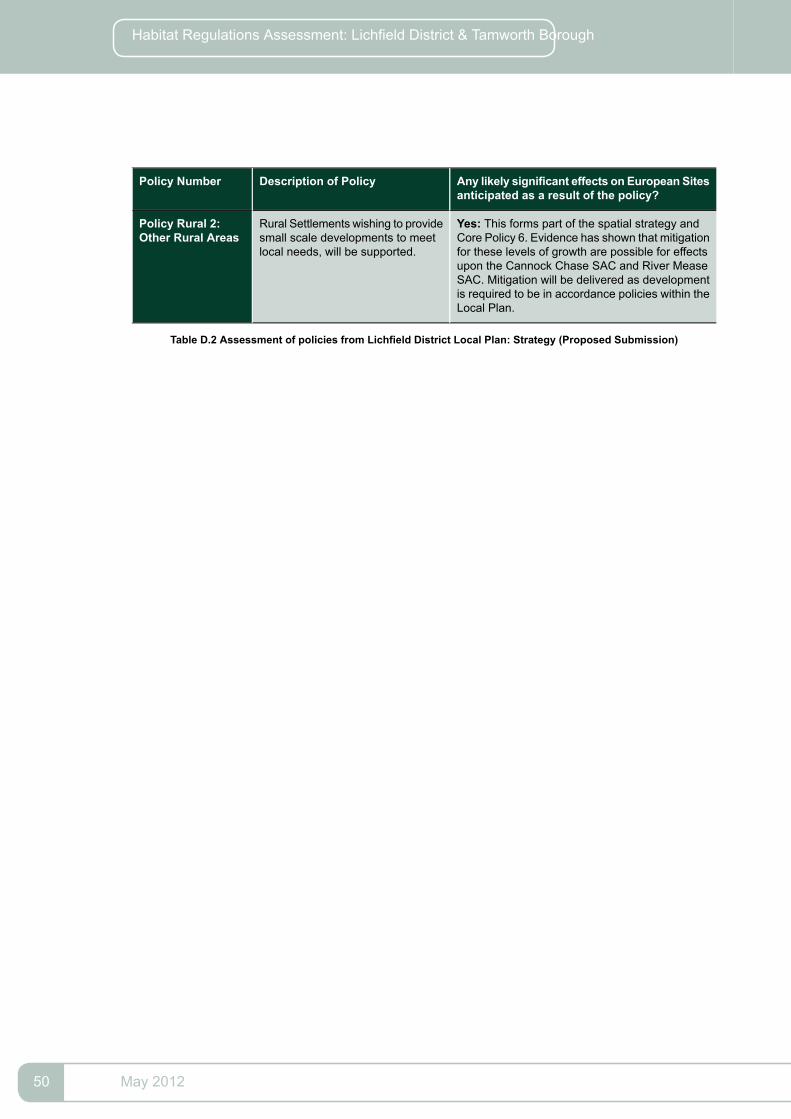
Any likely significant effects on European Sitesanticipated as a result of the policy?
Description of PolicyPolicy Number
Yes: This forms part of the spatial strategy andCore Policy 6. Evidence has shown that mitigation
Rural Settlements wishing to providesmall scale developments to meetlocal needs, will be supported.
Policy Rural 2:Other Rural Areas
for these levels of growth are possible for effectsupon the Cannock Chase SAC and River MeaseSAC. Mitigation will be delivered as developmentis required to be in accordance policies within theLocal Plan.
Table D.2 Assessment of policies from Lichfield District Local Plan: Strategy (Proposed Submission)
May 201250
Habitat Regulations Assessment: Lichfield District & Tamworth Borough

Appendix E Review of Proposed Policies in Tamworth BoroughLocal Plan
Any likely significant effects onEuropean Sites anticipated as aresult of the policy?
Remit of PolicyPolicyDescription
No: The strategy is based on deliveringdevelopment in sustainable locations
Provides a guide to how the spatial vision andstrategic objectives will be achieved in practical
SP1: A SpatialStrategy forTamworth supplemented by improvements to theterms. The role of the spatial strategy is to set out
natural environment. The impact of thehow much development there will be, broadlyAnker Valley allocation is covered inthe assessment of Policy SP6.
where it will go, when it will take place and who willdeliver it. It emphasises the ‘centres first’ objective,spatial direction for delivering housing andemployment needs whilst identifying key spatialpriorities for infrastructure and environmentalimprovements.
No: The town centre lies outside of the12 mile zone of influence for Cannock
Identifies strategic sites and opportunities for retail,leisure, culture/tourism & office development along
SP2: Supportinginvestment in
Chase SAC and no proposals whichexceed 100 dwellings are proposed.
with encouraging higher density residential andimproved linkages within the town centre and to
Tamworth TownCentre
the out of centre retail areas. It also identifies thekey gateway sites and introduces design andconservation principles.
No: No large scale developments areproposed by this policy.
Sets out guidance for achieving environmental andaccessibility improvements and where applicable
SP3: Supportinginvestment in
linked to delivering community regenerationobjectives.
local &neighbourhoodcentres
No: The employment areas are locatedoutside of the 12mile zone of influence
Identifies the employment land requirement alongwith main employment sites, and introduces a
SP4: Sustainableeconomicgrowth
for Cannock Chase SAC and noproposed two tiered approach; ‘strategic sites’ andproposals which exceed 100 dwellingsare proposed.
‘local sites’ to ensure Tamworth has sufficientcapacity to serve need whilst offering a degree offlexibility over allowing future housing developmentin the more poorly performing local sites. The policyalso sets out environmental and accessibilityrelated improvements required to regenerate andenhance employment sites.
No: Notwithstanding Anker Valleystrategic location, no other strategichousing sites are proposed
This policy will set out the overall future housingneed release of land to achieve a balanced deliveryover the plan period to meet identified housing
SP5: Housingdelivery
need including the criteria for achieving high qualitydevelopment in sustainable locations.
Yes: The proposal exceeds 100dwellings and will be required to
Includes a criteria based policy for delivering theproposed strategic housing site including the
SP6: AnkerValley
include an assessment of measureshousing numbers and associated infrastructureSustainableto mitigate any impacts on therequired to deliver a new sustainable
neighbourhood.UrbanNeighbourhood Cannock Chase SAC. Reference is
made within the policy which requiresthe delivery of social, physical andgreen infrastructure including a SANG.
51May 2012

Any likely significant effects onEuropean Sites anticipated as aresult of the policy?
Remit of PolicyPolicyDescription
No: The Regeneration Priority Areasare located outside of the 12 mile zone
Identifies Regeneration Priority Areas: Post WarSocial Housing areas, and the Wilnecote Corridor
SP7:RegenerationPriority Areas of influence for Cannock Chase SACas a result of them demonstrating high levels of
and no proposals which exceed 100dwellings are proposed.
deprivation and/or a poor quality environment. Setsout a series of priorities to address in each areaand commits the council and its partners to workin partnership to deliver spatial interventions toimprove the physical environment and deliver socialand economic renewal.
No: However, the policy seeks toprotect and enhance natural
Maps green and blue infrastructure and identifiesa series of priority areas and schemes and policy
SP8:EnvironmentalAssets infrastructure which have the potentialprinciples to deliver enhancements and
to act as alternative destinations toimprovements. These include improving andCannock Chase SAC thus mitigatingimpacts.
enhancing the network of green linear linkagesacross the town and to the, canal and river network.
No: The policy seeks to enable betteraccess to facilities through alternative
Identifies the supporting infrastructure required todeliver the sustainable pattern of growth identified
SP9: SustainableInfrastructure
to car use and ensuring developmentin the strategy. It refers to key strategic locationsis located in sustainable locationsfor transport improvements including to A5whilst tackling congestion. Thejunctions, Anker Valley Linkages, Tamworth &emphasis on low carbon developmentWilnecote stations, cycle and pedestrian routesand renewable energy should helpalong with general principles for improvingmitigate against the effects of climatechange.
accessibility. The policy also seeks to providecommunity facilities in accessible locations whilstpromoting opportunities for zero carbondevelopment and maximising opportunities forrenewable energy generation and mapping theareas at risk of flooding.
No: The policy relates to assessing theimpact upon the viability and vitality ofretail proposals on other retail centres.
Reinforces the ‘centre first’ approach to deliveringidentified future convenience and comparison retailneed and defines the hierarchy of centres and sets
CP1: Hierarchyof centres
out acceptable uses in each tier of centre. Sets outthe approach to retail & leisure proposals outsideof centres including floor space thresholds as abasis to undertake impact assessments. Sets outrestrictions on future retail/leisure expansion at outof town retail parks.
No: Not site specific and does resultin development directly.
This policy defines the acceptable uses within theemployment areas- B1 (b,c), B2 & B8.Provides
CP2:EmploymentAreas detail of environmental and accessibility
improvements. Promotes preferred location foroffices as being the town centre and edge of centrelocations and refers to identified strategic sites.Also introduces Local Development Orders aspotential delivery mechanisms for strategic sites.
No: No direct impact. The policypromotes and protects designated
Sets out support for tourism and culture leddevelopment; in particular related to the town
CP3: Supportinggrowth in culture& tourism nature and natural sites which may actcentre and its proposed leisure zone. Identified
as an alternative destinations (SANGs)supporting infrastructure including hotels andto Cannock Chase SAC therefore
May 201252
Habitat Regulations Assessment: Lichfield District & Tamworth Borough

Any likely significant effects onEuropean Sites anticipated as aresult of the policy?
Remit of PolicyPolicyDescription
reducing visitor numbers andassociated impacts on the SAC.
accessibility improvements including to DraytonManor
No: Not site specific and does resultin development directly.
This policy will establish thresholds and the levelof developer contribution towards the provision ofaffordable housing target.
CP4: AffordableHousing
No: Not site specific and does resultin development directly.
The policy will establish standards for new housingdevelopment including the size and type of units,
CP5: Housingneeds
specific types based on evidence arising from theongoing update of the Housing Needs Study.
No: Not site specific and does resultin development directly.
This will contain a banded density target forparticular borough wide locations including a higher
CP6: Housingdensity
density target for centres, transport nodes and alower target for elsewhere whilst respecting thelocal context.
No: Not site specific and does resultin development directly.
Whilst not allocating specific sites, this policyestablishes criteria for assessing applications forsite proposals.
CP7: Gypsy&Travellerprovision
No: No direct impact identified.This provides and promotes a network of highquality sport and recreation facilities across the
CP8: Sport &Recreation
borough to meet needs whilst aiming to protectexisting facilities.
No: The policy seeks to protect andenhance the natural environment.
This seeks to protect the existing network of highquality open space across the borough and sets
CP9:OpenSpace
out criteria for assessing proposals which involvea loss of open space.
No: The policy relates to the existingbuilt fabric.
This policy introduces a number of principles toachieve high quality buildings and places.
CP10: Design ofnewdevelopment
No: The policy relates primarily to theexisting built fabric.
This includes a list of principles to be consideredwhen proposing development which impacts on
CP11: Protectingthe historicenvironment the historic environment including listed buildings,
Conservation Area & scheduled monuments.
No: The policy seeks to protectbiodiversity and would thus prevent
This aims to preserve sites and species, reinforcelinks between habitats and ensure appropriate
CP12: Protectingand enhancingbiodiversity harm to the SAC. The policy seeks toconsideration to development depending on status
safeguard the SAC and identifies thatof sites i.e. national and local. It also encouragesdevelopment over 100 dwellings radiushabitat restoration and creation, with emphasis on
community led initiatives and list priority schemes. may have an impact and needs toidentify what that impact is anddemonstrate how that impact will bemitigated including provision ofalternative natural green creationalspace. The policy should have apositive impact upon the SAC.
53May 2012

Any likely significant effects onEuropean Sites anticipated as aresult of the policy?
Remit of PolicyPolicyDescription
No: The policy does not proposedevelopment it seeks the provision of
The policy sets out priority measures for improvingaccessibility and linkages, particularly by public
CP13: DeliveringSustainableTransport sustainable transport opportunities andtransport, walking and cycling on a borough wide
the reduction of use of the private car,basis and to/from strategic development sites. andwhich could have positive effects uponsets out the criteria for the requirement for transport
assessments and travel plans. SACs vulnerable from air-bornepollution.
No: Not site specific and does resultin development directly. Policy seeks
This supports measures to achieve carbon zerodevelopment including renewable energy proposalsand resource management.
CP14:SustainableDevelopment & to lower the demand for energy whichClimate ChangeMitigation
could have a positive effect upon theMease SAC.
No: The Mease SAC is sensitive tochanges in water quality and this policy
This policy requires new development to considerareas susceptible to fluvial and pluvial flooding
CP15: WaterManagement
seeks to prevent a negative impactupon water quality and abstraction.
including the application of SUDs and sustainableurban design.
No: Not site specific and does resultin development directly.
This sets out support for community facilities andinfrastructure to be located in accessible locations
CP16: Providingand protecting
and encourages dual use to be considered whereappropriate in sustainable locations.
CommunityInfrastructure
No: The policy refers to theInfrastructure Delivery Plan which has
This policy includes the key infrastructure requiredto deliver the strategy and introduces theInfrastructure Delivery Plan.
CP17:Infrastructure &DeveloperContributions
identified strategic infrastructurerequirements. These include waterand sewage which could protect waterquality and quantity and visitormitigation required to protect theCannock Chase SACandRiverMeaseSAC.
Table E.1 Assessment of policies from Tamworth Borough Local Plan
May 201254
Habitat Regulations Assessment: Lichfield District & Tamworth Borough

Appendix F Critical Friend Review of HRA
55May 2012

May 201256
Habitat Regulations Assessment: Lichfield District & Tamworth Borough

57May 2012

May 201258
Habitat Regulations Assessment: Lichfield District & Tamworth Borough

Picture F.1
59May 2012

Glossary
An assessment of potential effects of a proposed plan,in-combination with other plans and projects, on one or moreNatura 2000 sites or Ramsar sites
AAAppropriateAssessment
The statutory adviser to Government on UK and internationalnature conservation
JNCCJoint NatureConservationCommittee
The plan for the future development of the local area, drawn upby the local planning authority in consultation with the community.
Local Plan
In law this is described as the development plan documentsadopted under the Planning and Compulsory Purchase Act 2004.
Includes sites which are designated as Special Areas ofConservation, Special Protection Areas and Offshore Marine Sites
Natura 2000
Specific site designated for supporting internationally importantwetland habitats and are listed under theWetlands of International
Ramsar Site
Importance especially asWaterfowl habitat, (Ramsar Convention,1971
A Strategy for how a region should look over a 15-20 year period.It identifies the scale and distribution of new housing, indicates
RSSRegional SpatialStrategy
areas for regeneration, expansion or sub-regional planning andspecifies priorities for the environment, transport, infrastructure,economic development, agriculture, minerals and waste treatmentand disposal.
Strictly protected sites for rare or threatened species and habitatson land or sea as designated by the EC Habitats Directive
SACSpecial Area ofConservation
Sites classified in accordance with Article 4 of the EC BirdsDirective April 1979, classified for rare and vulnerable birds as
SPASpecial ProtectionArea
listed in Annex 1 of the Directive and for regularly occurringmigratory species.
Specific features or environmental conditions which are likely tohave a significant effect on a protected site
Significant EffectsIndicators
Waste Water Treatment WorksWwTwWaste WaterTreatment Works
Table .1
May 201260
Habitat Regulations Assessment: Lichfield District & Tamworth Borough