hindisahityasimanchal.files.wordpress.com · web viewaerial view of the andaman islands there are...
TRANSCRIPT

Geography
Aerial view of the Andaman Islands
There are 572 islands in the territory, of which only approximately 38 are permanently inhabited. Most of the islands (about 550) are in the Andamans group, 26 of which are inhabited. The smaller Nicobars comprise some 22 main islands (10 inhabited). The Andamans and Nicobars are separated by a channel (the Ten Degree Channel) some 150 km wide.
The total area of the Andaman Islands is some 6,408 km2 (2,474 sq mi); that of the Nicobar Islands approximately 1,841 km2 (711 sq mi).
HistoryFirst inhabitants
The Andaman and Nicobar islands have been inhabited for several thousand years, at the very least. The earliest archaeological evidence yet documented goes back some 2,200 years; however, the indications from genetic, cultural and linguistic isolation studies point to habitation going back 30,000 to 60,000 years, well into the Middle Paleolithic.[2]
In the Andaman Islands, the various Andamanese peoples maintained their separated existence through the vast majority of this time, diversifying into distinct linguistic, cultural and territorial groups. By the 1850s when they first came into sustained contact by outside groups, the indigenous peoples of the Andamans were:
the Great Andamanese, who collectively represented at least 10 distinct sub-groups and languages;
the Jarawa;
the Jangil (or Rutland Jarawa);
the Onge; and
the Sentinelese (most isolated of all the groups).
In total, these peoples numbered somewhere around 7,000 at the time of these first encounters. As the numbers of settlers from the mainland increased (at first mostly prisoners and involuntary indentured labourers, later purposely recruited farmers), these indigenous peoples lost territory and numbers in the face of land encroachment and the effects of various epidemic diseases. The Jangil and most of the Great Andamanese groups soon became

extinct; presently there remain only approximately 400-450 indigenous Andamanese, the Jarawa and Sentinelese in particular maintaining a steadfast independence and refusing most attempts at contact.
The indigenous peoples of the Nicobars (unrelated to the Andamanese) have a similarly isolated and lengthy association with the islands. There are two main groups:
the Nicobarese, or Nicobari, living throughout many of the islands; and the Shompen, restricted to the interior of Great Nicobar.
Demographics The major languages spoken in the Andamans in numerical order are
Bengali, Hindi, Tamil, Nicobarese and Telugu. Other languages include Malayalam and English. [5] The majority of Andamans are Hindus, but there are significant Muslims and Christian and Sikh minorities.
Foreigners wishing to visit the Andaman and Nicobar Islands require a Restricted Area Permit; however, there are now available on arrival at Port Blair's Veer Savarkar Airport.
The Andaman & Nicobar Islands pronunciation (help·info) (Bengali: আন্দামান ও নিনকাবর দ্বীপপুঞ্জ , Tamil: அந்தமான் நிக்க�ாபார் தீவு�ள்) is a Union Territory of India. Informally, the territory's name is often abbreviated to A & N Islands, or ANI.
The territory is located in the Indian Ocean, and geographically is considered part of Southeast Asia. It comprises two island groups, the Andaman Islands and the Nicobar Islands, separated by the 10° N parallel, with the Andamans to the north of this latitude, and the Nicobars to the south. The Andaman Sea lies to the east and the Bay of Bengal to the west.
The territory's capital is the Andamanese town of Port Blair. The territory's population as per the most recent (2001) Census of India was 356,152. Added together, the total land area of the territory is approximately 6,496 km² or 2,508 sq mi.
Country India
District(s) 3
Established 1956-11-01
Capital Port Blair
Largest city Port Blair
Lt. Governor Lieutenant General Bhopinder Singh

Population• Density
356,1521 (32)• 43 /km2 (111 /sq mi)
Language(s) Nicobarese, Bengali, English, Hindi,Tamil, Malayalam, Telugu
Time zone IST (UTC+5:30)
Area 8,250 km 2 (3,185 sq mi)
ISO 3166-2 IN-AN
Footnotes[show]
Website tourism.andaman.nic.in/
Effect of the 2004 Indian Ocean earthquake on India
Countries affected by the 2004 Indian Ocean earthquake.
In India, 10,136 people, according to official estimates, were killed and hundreds of thousands were rendered homeless when a tsunami triggered by the 2004 Indian Ocean earthquake near the Indonesian island of Sumatra hit the southern peninsular coast on 26 December 2004. The earthquake registered 9.0 in moment magnitude and was the biggest in five decades. This was followed by strong aftershocks, including a 7.1 magnitude quake [1] in the Andaman and Nicobar Islands.

Affected states and regions
Satellite photo of east coast of India, flooded by tsunami, 26 Dec 2004
Andaman and Nicobar
The Andaman and Nicobar Islands comprise 572 islands (all land masses in both low and high tides) out of which 38 are inhabited, both by people from the mainland and indigenous tribes. The islands lie just north of the earthquake epicentre, and the tsunami reached a height of 15 m in the southern Nicobar Islands. The official death toll is 1,310, and about 5,600 are still missing. The unofficial death toll (including those missing and presumed dead) is estimated to be about 7,000.
The Great Nicobar and Car Nicobar islands were the worst hit among all the islands because of their proximity to the quake and relative flatness. Aftershocks continue to rock the area. [2] One fifth of the population of the Nicobar Islands is said to be dead, injured or missing ([3]). Chowra Island has lost two thirds of its population of 1,500. Entire islands have been washed away, and the island of Trinket has been split in two ([4]). Communications have not been restored with the Nancowry group of islands, some of which have been completely submerged, with the total number of the population still out of contact exceeding 7,000 ([5]).
Among the casualties in Car Nicobar, 111 Indian Air Force personnel and their family members were washed away when the wave hit their air base, which was reported to have been severely damaged ([6]). The St. Thomas Cathedral (also known as the John Richardson church after John Richardson, a missionary and member of parliament) was washed away. The church, established in 1930 was one of the oldest and prominent churches in the region.

A cricket stadium named after John Richardson and a statue dedicated to him were also washed away.
The majority of the population of Andaman Islands is made up of people from the mainland, mostly from West Bengal and Tamil Nadu. The natives of Andaman and Nicobar Islands are endangered tribal groups, such as the Jarawa, the Sentinelese, the Shompen, the Onge and the Great Andamanese. They are regarded as anthropologically significant as they are some of the world's most primitive tribes and considered the world's only link to ancient civilisation. Most of these tribes have maintained their aboriginal lifestyle for centuries, and government policy has been to not interfere with them unless absolutely essential.
It is reported that most of the native islanders survived the tsunami because they live on higher ground or far from the coast ([7]). The Onge (with a 2001 census population of 96), Jarawa (240), Sentinelese (39) and Great Andamanese (43) have been reached by survey teams and are confirmed to be safe although the number of dead is unknown. The Sentinelese live on a reserved island and are hostile to outsiders which is making it difficult for Indian officials to visit the island. They have shot arrows at helicopters sent to check on them. ([8],[9],[10]). In the Nicobar Islands, the Nicobarese, a Southeast Asian-looking tribe (2001 population of 28,653), have lost about 656 lives with 3,000 still missing. Surveys are being conducted on the Shompen (2001 census count of 398) located on Great Nicobar island.
India's only active volcano, Barren 1, located at Barren Island 135 kilometres (80 miles) northeast of the capital Port Blair, erupted because of increased seismic activity on 30 December 2004. People have been evacuated since then and there have been no reports of any casualties. India was highly affected as 700 children lost their parents.
History and GeographyThe Union Territory of the Andaman and Nicobar Islands, is situated between 6° and 14° North Latitude and 92° and 94° East Longitude. The islands located north of 10° north latitude are known as Andaman Group of islands while islands located south of 10° north latitude are called Nicobar Group of islands. The climate of the islands can be defined as humid, tropical coastal climate. The islands receive rainfall from both the south west and north east monsoons and maximum precipitation is between May & December.
The original inhabitants of the islands lived in the forests on hunting and fishing. There are four Negrito tribes, viz., the Great Andamanese, Onge, Jarawa and Sentinalese in the Andaman group of islands and two Mongoloid tribes, viz., Nicobarese and Shompens in the Nicobar group of islands.
AgricultureA total of 51,694.35 hect. of area 8068.71 hect. under agriculture and plantation in the Andaman and Nicobar Islands was damaged by Tsunami/Earthquake. Out of that paddy and other field crops in 2177.70 hect. and 5891.01 hect. under plantation crops. Area under permanent submergence is 4206.64 hect. with paddy and other field crops.
Paddy the main food crop, is mostly cultivated in Andaman group of Islands, whereas Coconut and Areca nut are the cash crops of Nicobar group of Islands. Field crops, namely,

pulses, oilseeds and vegetable grown followed by paddy during Rabi season. Different kinds of fruits such as mango, sapota, orange, banana, papaya, pineapple and root crops are grown on hilly land owned by the farmers. Spices, viz. pepper, clove, nutmeg and cinnamon are grown under multitier cropping system. Rubber, red oil, palm and cashew are grown on a limited scale in these Islands.
IndustryThere are 1833 registered MSMEs and Handicrafts Units as on 31 March 2007. Two units are 100 per cent export oriented units in the line of Fish/Prawn processing activity. Apart from this, there are shells and wood based handicraft units. SSI units are engaged in the production of paints and varnishes, mini flour mills, soft drinks and beverages, steel furniture and fixtures, readymade garments, steel gate grills and structures. MSMEs handicraft units are also engaged in shell crafts, bakery products, rice-milling, furniture-making, etc. The Andaman and Nicobar Islands Integrated Development Corporation in the Public sector has spread its wings in the field of Tourism, Fisheries, Industries and Industrial financing and functions as authorized agents for Alliance Air/Jet Airways/Air Deccan.
TransportThe Motor Transport Department of A & N Administration operates from 13 stations in Northern and Southern group of islands. The department has a total number of 205 buses in operation mainly in rural area of A & N islands. Computerized ticketing for ATR express service has been implemented w.e.f. 15th August, 2007 where advance tickets can be obtained.
During the year 2007-08 a total of 135.88 lakh people travelled by the State Transport Service buses and the Department have generated revenue of Rs. 1075.22 lakhs. It is therefore evident that the Department has been making steady progress in not only providing better public transport service but also has been increasing its earnings.
TourismAndaman and Nicobar Islands have been recognised as an eco-friendly tourist's destination. As a tourist paradise, these islands have something very special to offer like Cellular Jail, Ross Island and Havelock Island.
The Andaman tropical evergreen rain forests, beautiful silver sandy beaches, serpentine mangrove-lines creeks, marine life abounding in rare species of plants, animals, corals, etc., provide a memorable experience to the tourists. There is tremendous scope for enjoying nature in the beach resorts, water sports and adventure water sports, adventure tourism like trekking, Island camping, Nature trail, Scuba Diving, etc.
Tourism Department runs guest houses in various parts of the Islands for comfortable accommodation to tourists visiting these Islands. The important places of tourist interest are Anthropological Museum. Marine Museum, Water Sports Complex, Gandhi Park, North Bay, Viper Island, Ross Island, Chidiyatapu, (Bird watching), Red Skin Island, Corbyn's cove

Beach, Islands like Neil Island, Havelock Island, Cinque, Little Andaman, Diglipur (Ross and Smith), etc.
As regards the connectivity, the islands are well connected to the mainland by air and sea. Indian Airlines, Air Deccan, Jetlite operates to Port Blair from Kolkata and Chennai. There are regular passenger ship service from Chennai, Kolkata and Vishakhapatnam.
ForestsThe recorded forest area is 7,171 sq km of the total geographical area of the islands. Many types of forests are found in the islands, such as tropical wet evergreen, tropical semi evergreen, moist deciduous, littoral, mangrove and swamp forests. A large variety of timbers are found in the Andaman group of islands. The most valuable timbers are padauk and gurjan. These species are not found in Nicobar.
WildlifeThere are 96 Wildlife Sanctuaries, 9 National Parks and 1 Biosphere Reserve in these Islands.
Mammals - Out of 55 terrestrial and 7 Marine mammal species reported so far, 32 species are endemic.
Birds - As many as 246 species and sub species of birds are reported to inhabit these Islands, and of these, 99 species and sub species are endemic.
Reptiles - There are 76 terrestrial reptiles of these 24 species are endemic.
Marine Life - Islands harbour more than 1,200 species of fish, 350 species of echinoderms, 1,000 species of molluscs and many more lower forms of life. Among vertebrates dugongs, dolphins, whales, salt water crocodiles, sea turtles, sea snakes, etc., are common.
Coral and Coral reefs - So far, 179 species of corals belonging to 61 genera have been reported. Reefs are mostly fringing type on eastern coast and barrier type on the western.
सामान्य जानकारी के
अंडमान व नि�कोबार द्वीप समूह
स्थान
स्था� बंगाल की खाड़ी देशांतर 92 0 94 0 पूर्व� से
अक्षांश 6 0 14 0 कर�े के लिलए उत्तर
ऊंचाई ( उच्चतम प्वाइंट)

अंडमान द्वीप समूह
Saddle पीक (उत्तरी अंडमा� द्वीप) 732 मीटर निनकोबार द्वीप समूह
माउंट Thullier (गे्रट नि�कोबार द्वीप) 642 मीटर के्षत्र
कुल के्षत्र Sq.km 8249
अंडमा� जि&ला " 3106
नि�कोबार जि&ला " 1841
उत्तर और मध्य अंडमा� " 3302
शहरी के्षत्र " 16,64
ग्रामीण के्षत्र " 8232,36
लम्बाई और चौड़ाई
लम्बाई और चौड़ाई अंडमान द्वीप समूह के
कुल लम्बाई 467kms
अधि1कतम चौड़ाई 52 निकलोमीटर औसत चौड़ाई 24kms
लम्बाई और चौड़ाई निनकोबार द्वीप समूह के
कुल लम्बाई 259 निकलोमीटर Maxiimum चौड़ाई 58 निकलोमीटर
सबसे बड़ी निनवासी अंडमान द्वीप समूह में मध्य अंडमा� द्वीप 1536 Sq.Km
सबसे बड़ी निनवासी निनकोबार द्वीप समूह में गे्रट नि�कोबार द्वीप 1045 Sq.Km.
छोटा निनवासी अंडमान द्वीप समूह में Curlew द्वीप 0.3 र्वग� निकमी.
छोटा निनवासी निनकोबार द्वीप समूह में Pilomillow द्वीप 1.3 Sq.Km
दूरी दूरस्थ सागर द्वारा (निकलोमीटर में.)

पोट� ब्लेयर और चेन्नई के बीच 1190
पोट� ब्लेयर और कोलकाता के बीच 1255
पोट� ब्लेयर और Vishakapatnam के बीच 1200
दूरस्थ एयर निकलोमीटर के द्वारा. कोलकाता और पोट� ब्लेयर के बीच 1301
चेन्नई और पोट� ब्लेयर के बीच 1375
प्रशासनिनक इकाई
प्रशासनिनक इकाई �हीं जि&ला 3
उप प्रभाग 6
Tahsil 9
कस्बा 3
CDBlock 5
लोकसभा सीट 1
�गरपालिलका परिरषद 1
�गर र्वाड� 18
पंचायत 67
पुलिलस स्टेश� 15
पंचायत सधिमनित 07
जि&ला परिरषद 01
द्वीप / ग्राम Nos.
रा&स्र्व ग्राम 204
&�गण�ा ग्राम 547
बसा गांर्व 501
नि�&�� गांर्व 46
बसे हुए द्वीप 38
जलवायु
सामान्य र्वषा� पोट� ब्लेयर में 3180 धिममी 2003 के दौरा� पोट� ब्लेयर में र्वास्तनिर्वक र्वषा� 3004.2 धिममी

2003 के दौरा� पोट� ब्लेयर में बरसात के दिद�ों 149
पोट� ब्लेयर में 2003 के दौरा� न्यू�तम तापमा� मतलब
23.9 0 सेल्सिBसयस
पोट� ब्लेयर में 2003 के दौरा� अधि1कतम तापमा� मतलब
30.2 0 सेल्सिBसयस
पोट� ब्लेयर के दौरा� 2003 में सापेक्ष आर्द्र�ता मतलब
81%
जनसंख्या कुल जनसंख्या 1971 1981 1991 2001
115133 188741 280661 356152
�र 70027 107261 154369 192972
मादा 45106 81480 126292 163180
ग्रामीण जनसंख्या 88915 139107 205706 239954
�र 53195 78401 111986 128961
मादा 35720 60706 93720 110993
शहरी जनसंख्या 26218 49634 74955 116198
�र 16832 28860 42383 64011
मादा 9386 20774 32572 52187
धम4 के अ�ुसार जनसंख्या धम4 1971 1981 1991 2001
हिहंदु 70134
121793 189521 246589
निHश्चिJय� 30342
48274 67211 77178
मुल्सिस्लम 11655
16188 21354 29265
लिसख 865 991 1350 1587
बौद्ध 103 127 322 421
&ै� 14 11 17 23
अन्य 2020 1357 886 1089
साक्षरता दर

(भारत की जनगणना के अनुसार - 1 माच4 2001)
नर मादा कुल
अंडमा� र्व नि�कोबार द्वीप समूह 71.07% 76.09%
65.15%
संर्वेद�शील &�&ातीय समूह पर एक संश्चिक्षप्त �ोट
निर्वशेष रूप से संर्वेद�शील &�&ातीय समूह है &ो निक अंडमा� और नि�कोबार द्वीप समूह में पहचा� की गई है (PTGs). र्वे मुझे) गे्रट Andamanese &लसंयोगी Islandii के) Onges लिलदिटल अंडमा� के iii) Jarawas दश्चिक्षण और मध्य अंडमा� (iv) Sentinelese प्रहरी Islands.and 1् के) Shompens गे्रट नि�कोबार के हैं
कला और शिशल्प निनकोबारी जनजानित के
कल्याण Jarawas और Sentinelese की
(i) महान Andamanese: --
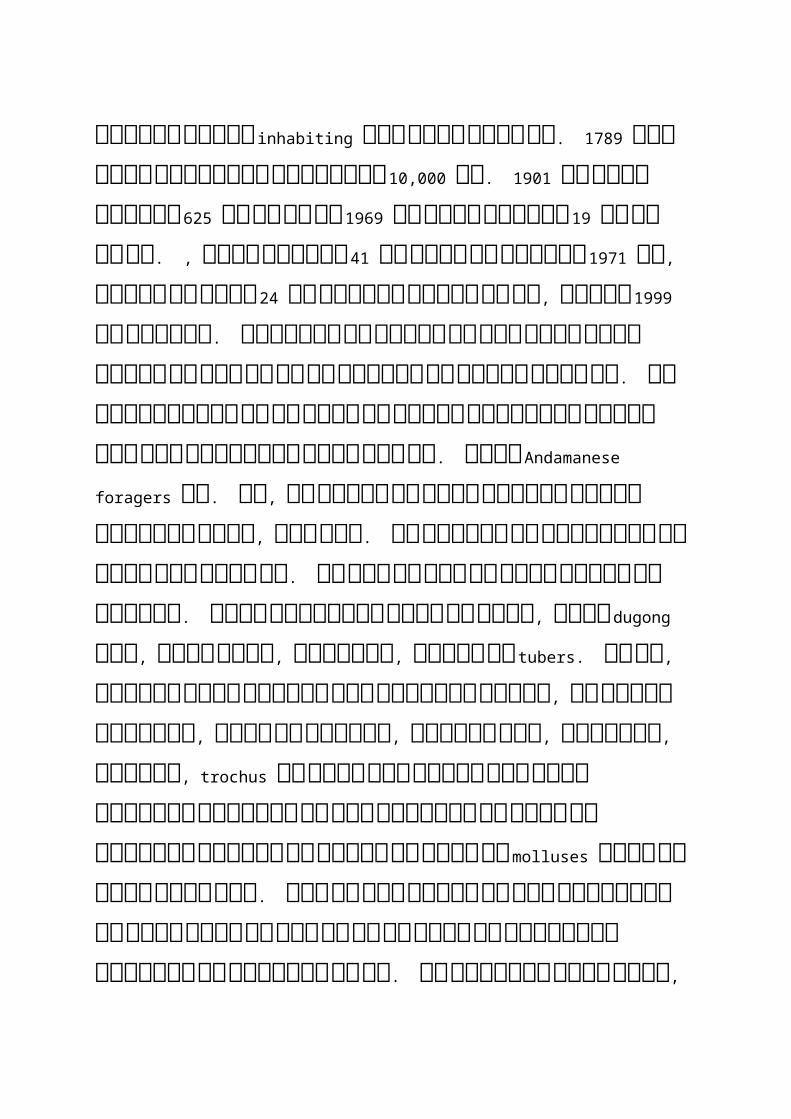
र्वे एक बार &�संख्या में निर्वश्चिभन्न &�&ानितयों के अंडमा� द्वीप inhabiting बीच सबसे बडे़ थ.े 1789 में उ�की अ�ुमानि�त &�संख्या 10,000 थी. 1901 तक उ�की संख्या 625 से कम था और 1969 तक उ�की संख्या 19 से कम ही थी. , उ�की संख्या 41 से बढ़ा था &�गण�ा 1971 की, उ�में से केर्वल 24 के अ�ुसार चारों ओर थ,े लेनिक� 1999 के द्वारा. प्रशास� की रक्षा के लिलए अप�ी पूरी कोलिशश कर रहा है और इस &�&ानित की रक्षा करता है. इ� आदिदर्वालिसयों का एक छोटा सा द्वीप &लसंयोगी द्वीप �ाम में पु�र्वा�स निकया गया है. महा� Andamanese foragers थ.े आ&, र्वे चपाती और अन्य आ1ुनि�क खाद्य र्वस्तुओं चार्वल, दाल खाओ. र्वे मसालों का इस्तेमाल कर खा�ा ब�ा सकता है. कई बार र्वे अभी भी &ा�े लिशकार और &�समूह. उ�के पारंपरिरक आहार की मछली, कछुआ dugong हैं, कछुआ अंडे, केकड़ों, &ड़ें और tubers. र्वे भी, अंडमा� पा�ी लिछपकली आदिद तटर्वतZ लोगों, र्वे स्र्वाद ऑक्टोपस, &ैसा निक देखरेख, निबचू्छ शैल, 1ूपघड़ी, हेलमेट, trochus और पेंच खोल पगड़ी खोल &ैसे समुर्द्री &ा�र्वरों का खोल केकड़ों और मछली के निर्वश्चिभन्न प्रकार के अलार्वा से बाहर ले molluses सुअर का मांस खाते हैं. हाल ही में उ�में से कुछ सल्सिब्&यों की खेती कर�े के लिलए और भी ले लिलया है पॉBट्री फामb की स्थाप�ा की है. र्वे अस्र्वस्थ पी�े र्वाला, गैर, शहरी, प्रमुख आदिदर्वासी और उन्नत समुदायों के साथ संपक� के बाद अधि1ग्रहण के अलार्वा संचारी रोगों के लिलए &ोखिखम रहता है.

ii) ONGE: --
Onges एक भारत में सबसे आदिदम &�&ानितयों के हैं. र्वे Negrito �स्लीय शेयर कर�े के लिलए हैं और र्वे लिलदिटल अंडमा� द्वीप में Dugong Hीक में आरक्षण के लिलए relegated निकया गया है. र्वे एक अद्ध� घुमंतू &�&ानित और पूरी तरह से खा�ा समथ�क स्र्वभार्व से vided पर नि�भ�र हैं. र्वे अब, उन्हें befriending पर प्रयास के रूप में सफल सानिबत कर दिदया है बाहरी लोगों के प्रभार्व को महसूस निकया है. उन्हों�े पक्का मका�, भो&�, कपडे़, प्रशास� द्वारा दर्वा आदिद उपलब्ध कराए &ा चुके हैं. र्वे, मछली, र्वे artistry और लिशBप का निर्वकास निकया है &ड़ें और &ैक फल आदिद कछुआ खाओ. इस Onges canoes कर सकते हैं. एक प्राथधिमक निर्वद्यालय भी Onges के Dugong Hीक नि�पटा� पर काय� कर रहा है. इस &�&ानित की &�संख्या ल्सिस्थर है और र्वत�मा� 94 पर है.
iii) JARAWAS:
341 की अ�ुमानि�त &�संख्या के साथ Jarawa गोत्राों अंडमा� द्वीपों दश्चिक्षण एर्वं मध्य के पश्चिJमी coasts
रहती है. र्वे लिशकार और भीड़ के अप�े सामान्य &ीर्व� &ी रहे हैं. गृह मंत्रालय, सरकार की. भारत, परामश� में &�&ातीय काय� मंत्रालय और अंडमा� र्व नि�कोबार के प्रशास� के साथ की, निर्वश्चिभन्न के्षत्रों के निर्वशेषज्ञों की लिसफारिरशों के आ1ार पर Jarawa &�&ानित अंडमा� द्वीप पर एक �ीनित को अंनितम रूप दिदया था. इस �ीनित में दिदसंबर, 2004 में अधि1सूलिचत निकया गया था सख्ती संरक्षण और Jarawas के कBयाण को सुनि�श्चिJत कर�े के लिलए काया�न्विन्र्वत की &ा रही है. आदेश में आ1ारिरत है, 847 से 1028 र्वग� को बढ़ाकर �े Jarawa आरश्चिक्षत के्षत्र कर दिदया गया है &ंगली सुअर, कछुआ, ह�ी और मछली आदिद &ैसे परंपरागत भो&� र्व� के एक अमीर संसा1� को सुनि�श्चिJत कर�े के लिलए. निकमी. निर्वशेष समुर्द्री संसा1� आ1ार भी तटीय पा�ी तक आदिदर्वासी आरश्चिक्षत के रूप में उच्च ज्र्वार रेखा से 5 निकमी की घोषणा से बढ़ा दिदया गया है. निर्वशेष र्वाड� प्राथधिमक स्र्वास्थ्य केन्र्द्र, Tushnabad, Kadamtala और &ीबी पंत अस्पताल, पोट� ब्लेयर Jarawas के लिलए और इस तरह के र्वाड� आदिदर्वासी भंडार उ�के साथ बातचीत से उत्सुक गैर आदिदर्वालिसयों को रोक�े के लिलए घोनिषत कर रहे हैं प्रदा� की गई है. इस Jarawa रोनिगयों को इ� केन्र्द्रों में इला& निकया &ा रहा है. 5 निकमी के दायरे के बफर &ो� का Jarawa रिरज़र्व� के आसपास है निक र्वे बडे़ पैमा�े पर पय�ट� या व्यार्वसाधियक गनितनिर्वधि1यों का अज्ञा� लक्ष्य ब� �हीं है यह सुनि�श्चिJत कर�े के लिलए अधि1सूलिचत निकया गया ह.ै

(iv) SENTENELESE: --
इस Sentinelese उत्तर प्रहरी द्वीप के नि�र्वालिसयों रहे हैं. इस के्षत्र के बारे में 60 र्वग� है. निकलोमीटर. र्वे शायद दुनि�या का एकमात्र Paleolithic लोग आ& निकसी अन्य समूह या समुदाय के साथ संपक� के निब�ा &ी रहे हैं. र्वे एक से, &ो एक और पृथक से संपक� खो दिदया है साथ में एक अलग पहचा� उ�की बस्ती की र्व&ह से प्राप्त कर लिलया है निक Onge Jarawa &�&ानितयों के लिलए शूटिटंग के रूप में मा�ा &ाता है मुख्य गोत्राों. यह बहुत Sentinelese और निर्वरो1ी हैं उ�के द्वीप को छोड़ कभी �हीं. बहुत कम इ� शत्रुतापूण� &�&ानितयों के बारे में &ा�ा &ाता है.
(v) SHOMPENS:
Shompens की बस्ती में गे्रट नि�कोबार &ो इस नि�कोबार द्वीप समूह के बीच में सबसे बड़ा है. इस Nicobarese की तरह, र्वे Mongoloid दौड़ के हैं. इस Shompens, छोटे प्रभाग Mawa Shompens के रूप में &ा�ा &ा रहा दो निडर्वी&�ों है. र्वे के्षत्रों बहुत �दी घादिटयों साथ तटीय के्षत्र के पास रहती है. र्वे बहुत शमZली हैं. र्वे काफी Nicobarese के साथ घनि�ष्ठ रहे हैं. Shompens के प्रमुख समूह के शत्रुतापूण� Shompens Alexendra और Galathia �दी और के्षत्रों में भी इस के्षत्र के पूर्वZ तट पर इस द्वीप के इंटीरिरयर में रह रहे हैं. अतीत में, लगातार हमलों के Mawa Shompens पर शत्रुतापूण� Shompens द्वारा निकया गया है कर�े के लिलए निर्वश्वास कर रहे हैं. लेनिक� अब ऐसी शत्रुता कर�ा बंद कर दिदया है. क्योंनिक र्वे मुख्यतः संख्या में निर्वश्चिभन्न रोगों के कारण कम हो गया है यह शायद है. इस Shompens रोग के लिशकार है, और शारीरिरक रूप से बहुत कम&ोर हैं. गे्रट नि�कोबार में कैम्पबेल बे में नि�पटा� की स्थाप�ा के साथ, Shompens �े settlers का दौरा निकया गया है और र्वे 1ीरे 1ीरे अप�ी लज्जा और सभ्य लोगों के प्रनित उपेक्षापूण� रर्वैया से निहल रहे हैं.

इस द्वीप समूह में पय4टन स्थलों देशों के साथ ही आ�ंद ले�े के लिलए देश कBप�ा की यात्रा के दौर में दुनि�या भर से पय�टक, मौसम, और लोगों को और ऐनितहालिसक स्मारकों उस स्था� में पाया. जि&समें कम से कम से बात भी कर रहे हैं स्था�ों का आ�ंद ले�े के लिलए कई पय�ट� स्थलों की है. द्वीपों के इ� निर्वलिशष्ट समूहों को भी उ� में कई पय�ट� स्थलों की है.
Chatham देखा धिमल है, एक एलिशया के सबसे बड़े देखा धिमलों के यहां अंगे्र&ों के शास�काल के दौरा� ब�ाया गया था. Patak, संगमरमर, क&�� और साट� की लकड़ी की तरह कीमती &ंगल planks, ब्लॉक और सो�े के निर्वश्चिभन्न आकार में सब काट रहे हैं. रे्व रासायनि�क समा1ा� में है और निफर बेचा निगर रहे हैं. ये आइलैंड र्वासी के लिलए और साथ ही अन्य राज्यों के लोगों को उ�की आर्वश्यकताओं के लिलए उपयोग निकया &ाता है. रे्व परधिमट मका�ों के लिलए इ� &ंगलों का उपयोग कर�े के लिलए &ा�ा होगा, सरकारी काया�लयों और कारखा�ों. कंटे�र &हा& द्वारा भारत में अन्य राज्यों के लिलए &ंगल के इ� निर्वशाल लॉग पूरा करते हैं. इस चक्की में 1000 कम�चारी काम करते हैं और सरकार के स्र्वाधिमत्र्व में हैं. पय�टकों को इस धिमल में इस प्रनिHया को देख�े के लिलए अ�ुमनित है.
इसमें एक संग्रहालय Hadoo, &ो पेड़ों के द्वीपों में उपलब्ध के प्रकार की एक दुका� है घर में र्व� निर्वभाग द्वारा निकया &ाता है. पेड़ और उसके प्रकार उ�के �ाम से प्रदर्शिशंत कर रहे हैं. लकड़ी के हस्तलिशBप का प्रदश�� कर रहे हैं और बेच दिदया. Hadoo भी &हाँ पक्षी, मगरमच्छ, बंदर, foxes, pythons, निहरण, &ंगली बकरी, सूअर, तोतों और कबूतरों की दुल�भ प्र&ानित पाई &ाती हैं एक धिम�ी लिचनिड़याघर है. इसमें &हां कोरल, गोले, मछली, समुर्द्री &ीर्व यहाँ पाया &ाता है एक �ौसैनि�क समुर्द्री संग्रहालय Samudrika पर Hadoo में स्थानिपत निकया है. �ौसे�ा के परिर1ा�, उपकरणों और हलिथयार भी प्रदर्शिशंत निकए &ाते हैं. हम भी इसी द्वीप के रृ्वत्तलिचत्रों पाते हैं. र्वहाँ बे, &हां हलिथयारों, बत��ों, झोपड़ी मॉडलों, लकड़ी �ौकाओं और मूल &�&ानितयों की तस्र्वीरें प्रदर्शिशंत निकया गया है फोनि�क्स में एक मा�र्वनिर्वज्ञा� संग्रहालय है. यह गोत्राों के एक पाँच सांस्कृनितक निर्वरासत को दशा�ती है. एक और राष्ट्रीय स्मारक के सेलुलर &ेल अटलांटा हिबंदु में &ो अंगे्र&ों द्वारा ब�ाया गया था ल्सिस्थत है. यह Hूरता और अंगे्र&ों �े भारतीय स्र्वतंत्रता से�ानि�यों पर लगाया Hूर व्यर्वहार का प्रतीक है.
र्वहाँ एक पालकों संग्रहालय Aberdeen के घाट ल्सिस्थत है बहुत अ&ीब समुर्द्र &ीर्व और पालकों में पाए &ाते हैं थे. महा� गुणर्वत्ता के Fishers यहाँ से नि�या�त निकया &ाता है. &ो &ा�कारी के बारे में पालकों इस संग्रहालय की यात्रा कर सकते हैं प्राप्त कर�े में दिदलचस्पी है. र्वहाँ एक समुर्द्र तट Corbyn है Cove Beach, &ो और एक सुन्दर समुर्द्र तट की रा&1ा�ी शहर के बगल में, �ारिरयल हथेलिलयों से धिघरा स्र्वाभानिर्वक है �ाम पर रखा गया है. पसंदीदा खेल समुर्द्र तैराकी, सूय� स्�ा�, और समुर्द्र तट तलाशी और सर्वारी कर रहे हैं. एक तैर�े के बाद कपडे़ बदल�े की सुनिर्व1ा है. एक भो&�ालय आसपास &हां हि}ंक्स और �ाश्ता धिमला &ा सकता है. लोग तो दूर, &ो समुर्द्र तट चेहरों के लिसतारा होटल में रहते हैं. एक पा�ी के खेल परिरसर Aberdeen घाट Aberdeen पा�ी के खेल, &हां �ौकाय� �ौकाओं, पेडल �ार्वों, kayaks एक्र्वा साइनिकल, एक्र्वा glides और भरपूर उपलब्ध हैं �ाम पर ल्सिस्थत है. र्वहाँ भी एक छोटा सा तालाब है. लोग गहरे समुर्द्र में पा�ी के खेल का आ�ंद सकता है.
एक समुर्द्री पाक� Aberdeen घाट के पास ल्सिस्थत है. यह परिरर्वार निपकनि�क के लिलए उपयुक्त &गह है और एक समुर्द्री हर्वा स्र्वाद कर सकते है. यह एक म�ोरं&� पाक� है. &ो बच्चों को यातायात के नि�यमों और सड़क सुरक्षा समझा�े एक खिखलौ�ा रेलगाड़ी और एक टै्रनिफक पाक� है. एक ध्र्वनि� और प्रकाश दिदखा�े की सेलुलर &ेल में निर्वशेष समय पर कर सकते हैं &हाँ एक गर्वाह निहन्दी दो�ों में है और अंगे्र&ी में अंगे्र&ों के भाग्य का रक्तमय &गहें &गह ले लेता है. दिटकट &ेल के प्रर्वेश द्वार पर बेच रहे हैं. जि&समें कें र्द्र सरकार का है इस Sipicot सेंट्रल कृनिष अ�ुसं1ा� फाम� पोट� ब्लेयर, शहर से लगभग 14 निकलोमीटर दूर के पास है. यह केन्र्द्र प्रयोगात्मक फसलों, सल्सिब्&यों, सुगं1 और इत्र cultivates. इस क्षेत्र के बारे में 80acres के एक खंड पर है. शो1कता�ओं का समुर्द्री &ीर्व और पालकों पर भी ब�ा रहे हैं.
Wandoor Beach और महात्मा गां1ी समुर्द्री राष्ट्रीय पाक� एक संुदर स्था� दूर पोट� ब्लेयर से 29km ल्सिस्थत है. महात्मा गां1ी समुर्द्री राष्ट्रीय पाक� है जि&सके बारे में 281.50gq.km. लोग मूँगे की राख के पार आए खिखंचार्व इ� द्वीपों पर नि�र्मिमंत निकया गया है, गहरे समुर्द्र &ा�र्वरों और mangrove &ंगलों यहाँ. प्राची� समय का समुर्द्र तट समुर्द्र तट कर�े के लिलए सौंदय� कहते हैं. पय�टकों को नि�श्चिJत रूप से यहाँ मज़ा प्यार करेंगे.
एक छोटे से बंदरगाह चाट�र �ौकाओं और Red त्र्वचा द्वीप बोया Jolly लिलए. इस &ेBली और बोया लाल त्र्वचा द्वीपों को महात्मा गां1ी पाक� के बंदरगाह हैं. साफ रेत और तरणताल इ� द्वीपों के लिलए मज़ा &ोड़ें. पा�ी साफ है और परिरर्वह�. निर्वश्चिभन्न रंग की मछली की बहुत भर में म�ुष्य के डर के निब�ा तैर�ा. गहरे समुर्द्र &ीर्व की &ीर्व� शैली देखी &ा सकती है. यह एक आ1े दिद� की यात्रा है. पय�टकों को उ�के साथ भो&� और पा�ी रख�ा चानिहए. माउंट Harriet, 55km के बारे में एक बड़ा पहाड़ दूर पोट� ब्लेयर, समुर्द्र तल से 365 मीटर के बारे में उठाए से. एक Pamp प्लॉट कर�े के लिलए �ार्व से यात्रा कर�े के लिलए है और गाड़ी से 15 निकमी यात्रा. फोएनि�क्स बे Ferry को �ार्वों के लिलए भूखंड बांस को शुरुआती हिबंदु है. राज्यपाल �े नि�दिटश साम्राज्य के अप�े गर्मिमयंों इस पर्व�त पर निबताया. पूरी सरकार भी यहाँ नि�दिटश शास� के दौरा� काय� निकया. यह एक शा�दार &गह र्वातार्वरण, सब्ज़ &ंगलों, एकांत, �ीला आकाश, दिदखाई आदिदम समुर्द्र coasts से भरी इस पहाड़ से दुल�भ स्था�ों रहे हैं. यह पर्व�त नि�&ी समय चाह�े के लिलए एक पसंदीदा &गह है और यह भी एक नि�मा�ता के लिलए स्र्वग� है. पहाड़ भी एक सरकारी पय�टक घर है.
रॉस द्वीप, &ो Aberdeen घाट के निर्वपरीत है निक रा&1ा�ी में नि�दिटश शास� के दौरा� निकया गया. अब इस �ौसैनि�क बल का एक निहस्सा है. यह फोनि�क्स बे के पास है. इस द्वीप cruises के माध्यम से पहुँचा &ा सकता है. कुछ खंडहर नि�दिटश अधि1कारिरयों द्वारा नि�र्मिमंत की अभी भी बाकी है. एक संग्रहालय का �ाम 'Smrithka' को �ौसे�ा के बल द्वारा अ�ुरश्चिक्षत भी यहीं ल्सिस्थत है. पत्र नि�दिटश अधि1कारिरयों, तस्र्वीरें और द्वीप के बारे में निर्वस्तृत दस्तारे्व&ी �े लिलखा की फोटो प्रनितयां संग्रहालय में पाए &ाते हैं. भूकंप के कारण, इस द्वीप के कुछ निहस्सों डूब रहे हैं. इस द्वीप पूरी तरह से कुछ र्वषb के बाद निर्वफल हो सकता है. पय�टकों बहुतायत में इस द्वीप में निहरण और मोर पा सकते हैं. यह दिद� के समय सुखद है. इस अंगे्र&ों के लिलए एक कनि�स्ता� है. यह द्वीप पूरी तरह �ारिरयल हथेलिलयों से धिघरा हुआ है. यह भी फुसफुसाती अतीत के शोकान्विन्र्वत कहानि�याँ.
Chidiya &ो Tapu दश्चिक्षण अंडमा� में है पोट� ब्लेयर से 26 निकमी दूर ल्सिस्थत है. &ंगलों यहाँ घ�े होते हैं और एक संुदर समुर्द्र तट है. यह एक गांर्व को पूरी तरह पश्चिक्षयों से आबाद है. पहाड़ों भययोग्य है सूया�स्त के बीच. Chidiya में Tapu पसंदीदा खेल और �ार्व की सर्वारी snorkeling हैं. सागरिरका में औद्योनिगक एम्पोरिरयम लकड़ी हस्तलिशBप पोट� ब्लेयर में सरकार द्वारा निकए गए के लिलए एक एम्पोरिरयम है. निर्वश्चिभन्न प्रकार के फ�Zचर, लकड़ी गुनिड़या, कुर्शिसंयाँ, बत�� लकड़ी, खोल गह�ों के चलते ब�ाया लकड़ी का ब�ा है और लिचपक स&ार्वटी लैंप इस एम्पोरिरयम में प्रदर्शिशंत कर रहे हैं. माल की कीमतों में सस्ते होते हैं.
गां1ी पाक� के लेल्सि�ट�ेंट गर्व��र के आर्वास के नि�कट ल्सिस्थत है. यह भी श्री Vetrimalai Murugan मंदिदर के पास ल्सिस्थत है. गां1ी पाक� में दिदल Dhaman झील का नि�मा�ण निकया है. यह पाक� एक प्राची� बुद्ध मंदिदर है. र्वहाँ भी एक बैठा ल्सिस्थनित में गां1ी की एक प्रनितमा है. यहाँ बच्चों के निर्वशालकाय पनिहयों, बम्पर �ौकाओं और �ार्व की सर्वारी का आ�ंद लें. इस &गह को अच्छी तरह से उ�के परिरर्वारों के लिलए सप्ताहांत का आ�ंद ले�े के लिलए अ�ुकूल है. र्वहां एक रेस्तरां भी इस पाक� में है. पोट� ब्लेयर Hू& की सर्वारी सुनिर्व1ाए.ँ पोट� ब्लेयर, पय�टकों और द्वीप समूह के लोगों से Hू& कुछ द्वीप रॉस द्वीप, Hadoo, Panighat, सांप द्वीप, हाब�र और फ़्लोटिटंग �ौर्वह� याड� &ैसे.
Madhar बाबा Durgah है Corbyn Cove कर�े के रास्ते में ल्सिस्थत है. ऐसा लगता है निक एक व्यलिक्त &ो बाबा की कृपा से धिमल &ाएगा कुछ प्राप्त कर�ा चाहता है मा�ा &ाता है. पशु 'बलिल आम होते हैं और भक्तों को भो&� के साथ परोसा &ाता है. लोग यहाँ भले ही उ�के डाली और पंथ के आते हैं. Rangat-बे Cutbert मध्य अंडमा� में जि&सके बारे में पोट� ब्लेयर से 170 निकलोमीटर दूर है. इस बे के लिलए transports का मतलब है दो�ों को सड़क माग� से �ार्व के साथ ही कर रहे हैं. &�संख्या यहाँ है निक पोट� ब्लेयर के बगल में है. गांर्व के पहाड़ों से धिघरा हुआ है. यह शांत &गह है और शांत हो &ाओ. कछुओं को इस गांर्व के तट रेखा पर अंडे

देते हैं. दो�ों सरकार और साथ ही नि�&ी resorts यहाँ है.
मध्य अंडमा� में एक और निपकनि�क स्पॉट आम है कंु& बीच, एक समुर्द्र तट Rangat में पाया. यह &गह व्यार्वसाधियक व्यर्वहाय�ता से भरा है. निर्वदेशी पय�टकों को &रूर म&ा करेंगे और इस &गह का आ�ंद लो. इस बीच में तरंगें बहुत अधि1क हैं और म&बूत. माया Bunder, 240 निकलोमीटर के बारे में एक घ�े &ंगल में भाग पोट� ब्लेयर से उत्तरी अंडमा� में है. र्वहाँ से एक बंदरगाह के नि�कट है. काया�लय शीष� पुलिलस अधि1कारिरयों, सरकारी काया�लयों और शैक्षश्चिणक संस्था�ों के यहाँ हैं. यह एक व्यस्त स्था� है. Karmatang बीच उत्तरी अंडमा� में भी माया Bunder से लगभग 10 निकलोमीटर दूर है. इस समुर्द्र तट की अप�ी सफेद लहरों के कारण संुदर है. एक सरकारी पय�टक घर 'यानित्रक Nivas ", इस बीच करीब है.
उत्तरी अंडमा� Diglipur है भी. एक �ौकाय� द्वारा Kalighat को माया Bunder और यात्रा से Diglipur को बस से Diglipur तक पहुँच�े के लिलए है. इसमें 46 निकमी सड़क के लिलए �हीं है. हालिथयों Diglipur कर�े के लिलए लकड़ी के लॉग गाड़ी. यहां प्रचुर मात्रा में हैं एक घ�े &ंगल Diglipur तक पहुँच�े के लिलए पार कर�ा होगा. बंगालिलयों. केर्वल कुछ Tamilians यहाँ पर ध्या� केजिन्र्द्रत कर�ा. इस Kalpang �दी एक प�निब&ली निब&ली परिरयो&�ा है. यह &गह. Havelock द्वीप का आ�ंद ले�े के लिलए दश्चिक्षण अंडमा� में है एक दिद� की &रूरत है. यह पोट� ब्लेयर से लगभग 30 निकलोमीटर दूर है. कोई सड़क परिरर्वह� है. यह एक शांनितपूण� द्वीप है. इस Havelock द्वीप, &ो एक प्राकृनितक एक है Rudhanagar बीच है. घ�े &ंगलों के समुर्द्र तट में पाए &ाते हैं. हालिथयों �हा�ा और ठंडा पेय पीते हैं. &ो यहाँ हर समय रह�े के लिलए प्यार प्रकृनित पे्रधिमयों.
�ील द्वीप पोट� ब्लेयर से 32 निकलोमीटर दूर है. एक पोट� ब्लेयर से द्वीप तक पहुँच�े के लिलए �ार्व से यात्रा कर�े के लिलए निकया है. यह एक बहुत छोटा सा द्वीप है. दो�ों बंगालिलयों और Tamilians यहाँ पर ध्या� केजिन्र्द्रत कर�ा. उद्या� फसलों यहां पाए &ाते हैं और रे्व पोट� ब्लेयर ले &ाया &ाता है. लोग &ो अकेले ही &ा रही अच्छी तरह इस &गह को सूट करेगा प्यार करते हैं. लिलदिटल अंडमा� थोड़ी दूर पोट� ब्लेयर से है और यह छोटा &हा& लिलदिटल अंडमा� की यात्रा कर�े की आर्वश्यकता है. इस यात्रा के समय दस घंटे है. हट बे लिलदिटल अंडमा� की रा&1ा�ी शहर है. अंडमा� और नि�कोबार द्वीप समूह हाब�र और बंगलादेश और Srilanka बस�ा से कुछ अन्य शरणार्शिथंयों की यहाँ के मुख्य काया�लय. फाम�, हथेलिलयों के पेड़, खेती कर रहे हैं. पाम तेल के कारखा�ों से नि�काली है. इस द्वीप के कें र्द्र भाग में एक निर्वशाल झर�ा है. इस नि�कोबारी &�&ानित का र्वास Harmandar बे द्वीप का एक निहस्सा है. इस Ongi गोत्राों Twank Hीक में रहते हैं. Malaka कार नि�कोबार में पाया &ाता है. प्रभु Murugan के लिलए एक मंदिदर के समुर्द्र तट पर ब�ाया गया है. एक मंदिदर में तधिमलों 'श्री Gnana Dhandayudhapani' Malaka में है द्वारा नि�र्मिमंत. निHश्चिJय� गोत्राों एक यहाँ बसा. कुछ Tamilians यहाँ पर ध्या� केजिन्र्द्रत कर�ा.
नि�कोबार की सीमा कैम्पबेल बे है. कैम्पबेल बे की यात्रा इंदिदरा निबन्दु कहा &ाता है. यह 60 मील दूर इंडो�ेलिशया से है. इस &गह के लिलए र्वास्तनिर्वक और ऐनितहालिसक �ाम प्राची� तधिमल सानिहत्य में Nakkavaram. Nakkavaram निर्वशेषताएं है. �दी Kalathiya यहाँ चलाता है. निर्वदेश कछुए द्वीप पर &ाए.ँ रे्व यहाँ पर अंडे देते हैं और र्वापस चले आते हैं. निक�ारे मगरमच्छ है. यह द्वीप भूकंप और चHर्वातों के द्वारा frequented है. पूर्व� - से�ा पुरुषों यहाँ रहते हैं.
इस द्वीप समूह में एक पय�ट� त्योहार है. यह पय�टकों बहुतायत में आ�े के लिलए प्रोत्सानिहत कर�े के लिलए आयोजि&त निकया &ाता है. इससे पहले निक त्योहार स&ार्वट &गह रख�ा शुरू होता है. त्योहार स्टालों के समय दो�ों को सरकारी और नि�&ी प्रदर्शिशंत कर रहे हैं. इस त्योहार पर चला &ाता है 10 दिद�ों के लिलए. हम संगीत, �ृत्य, कनिर्वता और बहस में अप�ी प्रनितभा का प्रदश�� दो�ों उत्तर भारतीय, दश्चिक्षण भारतीय कलाकारों की खो& कर सकते हैं. त्योहार फरर्वरी के दूसरे सप्ताह के दौरा� &गह लेता है हर साल. त्योहार का उद्घाट� एक र्वीआईपी द्वारा भारत से है. पोट� ब्लेयर के दौरा� सभी अधि1क भीड़ होगी इ� 10 दिद�.
The dreadful moment when the Tsunami of 26 December 2004 hits the Thai coast after travelling ca. 400 km around the northern tip of Sumatra and then WNW across the Andaman sea and the Strait of Malacca. The coast shown in this photograph is "sheltered" (if that is quite the word for it in these circumstances) by Sumatra. The epicentre of the earthquake was on the far side of Sumatra and the tsunami had to work its way around the northern tip of that island, losing a lot of energy in the process. The photograph captures only too clearly the tremendous power that even a weakened major tsunami can have.

The human figure on the left and the boats on the right can give a sense of scale. The unknown photographer did not survive and the same must be assumed for the human being. The camera was found later with the film intact. The exact part of the coast shown has not been identified. The breaking wave appears to be roughly 5-6 m high, which compares with the unimaginable wave of 30 m or even more that hit the town of Aceh much closer and in direct line to the epicentre
Tsunami
The Tragedy in Pictures
Warning:
There are pictures in this section that may be distressing to those with delicate sensibilities.
You look at these pictures at your own risk!

The arrival of the Tsunami The following sequence of six pictures was taken by a couple, Mr and Mrs John and Jackie Knill of North Vancouver, Canada, who were on a beach at Khao Lak resort in Thailand just before 10:11 a.m. on 26th December 2004. They saw the tsunami coming and took a series of pictures that are among the most impressive photographs to come out of the disaster.
Their camera was found later, washed up on a beach among other debris. Its chip still contained the couple's last pictures.
Mr and Mrs Knill died seconds after their last picture. Their bodies were found and identified.
May they and the countless other victims of the disaster rest in peace.
Photograph 1 shows the "false ebb" (receding waters) before the arrival of the tsunami which is just visible on the horizon

Photograph 2
Photograph 3
Photograph 4
Photograph 5 (note the lone human figure on the beach and the boats for comparison of size)

Photograph 6

The Nicobar Islands
Camorta Island (Nicobars)
30 Dec 2004 30 Dec 2004, Camorta jetty
30 Dec 2004, Camorta jetty 30 Dec 2004, Camorta jetty

30 Dec 2004, Rani Isge's grave
Car Nicobar Island
31 Dec 2004

31 Dec 2004, Mus village, jetty 31 Dec 2004, Mus village, jetty
Nancowry island (Champin village)
30 Dec 2004 30 Dec 2004
30 Dec 2004 30 Dec 2004

30 Dec 2004 30 Dec 2004
30 Dec 2004 30 Dec 2004
30 Dec 2004

Trinket Island
30 Dec 2004
Other and unknown locations
Nicobari survivors on their boat 26 Dec 2004, on a flooded island

31 Dec 2004, survivors on a rescue vessel 31 Dec 2004, survivors in a "daisy chain" of small boats being towed to safety
31Dec 2004, children praying on board a rescue vessel 31 Dec 2004, survivors on a rescue vessel
26 Dec 2004, flooding in Marirk "It is an ill wind that blows nobody any good"

- small businessmen use the opportunity after the disaster
Damage in unidentified Nicobarese places. Bottom right shows a doomed coconut grove, standing in salty water.

The Moken of the Thai Coast
The new Moken boat

The Moken reclaim Ko Surin

Building a new Moken village
Temporary tent accomodation on Ko Surin

Sumatra: closest to the epicenter
The city of Banda Aceh (population around 100,000). The city was visited by Marco Polo in 1292 abd by Ibn Battutah 1345/46. Apart from the ancient mosque, only ground-level rectangles show where houses have stood only days before the picture was taken.

Banda Aceh before 26th December 2004 Banda Aceh after 26th December 2004

Thailand
Left and below: nobody was spared:Bodies on the beach at Khao Lakwhere the tsunami reached a hight of 10.6 m.

An after-wave of the tsunami hits the beach of Patong on Phuket island in Thailand after the main wave. The main waves there reached 5.5 m.

Sri Lanka
The tsunami was "only" a little less than 4 m in height when it reached the southwestern coast of Sri Lanka. Yet it still had enough power to throw a train off the rails and kill more than 1000 of its passengers. The twisted rails shown above were found not far from the derailed train (photos: Jimin Lai / AFP, above; Shahidul Alam / DRIK, below).
