h - rhode island historical preservation & heritage … · heavily travelled north main street...
TRANSCRIPT

* UNI’i’LI S’I’.Vl’I:S II1’ ICIMLiNI’ UI’ TI lit IN H.RIORFOR NPS USE ONLY
NATIONAL PARK SERVICE
NATIONAL REGISTER OF HISTORIC PLACESRECEIVEQ *
INVENTORY -- NOMINATION FORM I DATE ENTERED **‘
SEE INSTRUCTIONS IN HOWTO COMPLErENATIONAL REGISTER FORMSTYPE ALL ENTRIES--COMPLETE APPLICABLE SECTIONS
NAME
HISTORIC
North Burial GroundAND/OR COMMON
LOCATION .
STREET& NUMBER Between Branch Avenue and North Main St.FOR PUBLICATION
CITY TOWN
Providence #1- Rep.CONGRESSIONAL DISTRICT
Pernand J. St..
GermainSTATE COOE COUNTY COOS
-- Rhode Island
CLASSIFICATION
44 Providence 007
OWNERSHIP
±PU B LI C
_,,PRPVATE
PUBLIC ACQUISITION
_IN PROCESS
.BEING CONSIDERED
STATUS
OCCU PIED
_UNOCCUPIED
_WORIK IN PROGRESS
ACCESSIBLE_YES: RESTRICTED
YES’ UNRESTRICTED
-NO
PRESENT USE
_AGRICULTURE
COMMERCIAL
.EDU CAT ID N A L
NTE B TA IN M EN T
OV E RN ME N T
_INDUSTRIAL
MILITAPY
-MUSEUM
PAR K
..PRIVATE RESIDENCE
RELPGIOUS
_SCIENTIFIC
_rRANSPORTATION
OTHER: cemetery
OWNER OF PROPERTYdo Vincent Lanzieri Jr.
NAMECity of Providence Superintendent, North Burial Ground
STREET & NUMBER
Branch AvenueCITY. TOWN STATE
Providence Rhode Island 02904
aL0CATION OF LEGAL DESCRIPTIONCOURTHOUSE.
REGISrRY OF DEEDS.ETC Providence City HallSTREEt & NUMBER
25 florrance SttZeetCITY, tOWN - STATE
Providence Rhode Island
REPRESENTATION IN EXISTING SURVEYS
TITLE
Providence BroadbruEhj Maunt Hope , -________
DATE
July 1976 ..FEDERAL XSTAIE COUN[Y
DEPOSItORY FOR -
SURVEYRECOROS Rhode Island Historical Preservation CommissionCITYTOWN STATE
Providence Rhode
p ‘‘ i .. , u’ rC/ ‘
iRev. 10.74
CATEGORY
DtSTRICT
_BUtLDINGISI
,STRUCTURE
SITE
_OBJECT
If
r
1-*’L.
DESCRIPTION ‘
CONDITION CHECK ONE CHECK ONE
EXCELLENT XDETERIDRATEO UNALTEHED X-ORIGI NAL SITE
000D _RUINS X..ALTERED _MOVED DArE I,
_FAIR UNEXP0SED ‘
DESCRIBETHE PRESENT AND ORIGINAL IF KNOWN PHYSICAL APPEARANCE * .
The North Burial Ground, located in ‘Providence just south of thePawtucket City Line, is bounded on the southwest by Branch Avenue, onthe northwest by Interstate Highway 95, on the north by Cemetery Street,and on the east by North Main Street. When the cemetery, the oldestcommon burial ground in Providence, was established in 1700, the areawas beyond the compact settlement in Providence. Late nineteenth andtwentieth-century urban growth have created commercial strips along’heavily travelled North Main Street arid Branch Avenue and lower middleclass residential neighborhoods to the north and east of the cemetery,isolating it as one of the largest open spaces in Providence.
The cemetery has grown from the ten acres set aside in 1700 to 150acres today, and includes over 100,000’ graves. Additions to the cemeterywere small and sporadic before the middle of the nineteenth century,whenthe grounds were vastly expanded to the north and replatted by the cityin keeping with the precepts of the rural cemetery movement, which wasthen achieving prominence. By 1870, the cemetery,had grown to itspresent size, although the development of the northern portion did notbegin until late in the nineteenth century. In the 1960’s a small portion of the northwest cornerwas removed from the cemetery to allow forthe construction of Interstate Highway 95.
The topography varies in the cemetery. A rolling plateau extendsnorth from the,entrance at ‘the junction of North Main Street and BranchAvenue. To the west. this plate’u slopes gently down to the ‘lowlands ofthe floshassuck River, now covered hy Interstate 95. A small pond, now
____
empty, once stood in this dell. The land rises abruptly at. the westernedge of the grounds where banking for Interstate Highway 95 has beenconstructed. To the north, the plateau ends in a curvilinear hillside,which gives way to a low-lying plain in the north and northwest of thegrounds. The flatness ‘of this area is relieved by an esker and an adjacent man-made pond just north of the center of the grounds, and a shortlength of the Blackstone Canal constructed in 1828 and already listed on frthe National Register which crosses the northwest corner of the grounds.
The cemetery is surrounded by a simple, early twentieth-centurywrought-iron picket fence’. The main entrance is at the cemetery’ssouthern end, at the junction of North Main Street and Branch Avenue.It is defined only by two simple wrought-iron gates that are part of theenclosing fence. Two auxiliary entrances on North Main Street are morelaborate. At the intersection of North Main Street and RochambeauAvenue, stand large stone gateposts, built to enframe a main’entrancein the late nineteenth century, which is now little used. In the north-east corner, at the junction of North Main and Cemetery Streets, a
____
pedestrian gate with a large, curving, double staircase, constructed inthe 1890’s, of stone left over from the construction of the, present
See’ continuation Sheet ‘ill

*
Form No. 1D3OD . . 1,.’ pIRe.v. 10-741
‘..
UNIILIJSFAISDIPARFMLNIOI till INIIRIOR FORNPSUSEONLYNATIONAL PARK SERVICE ‘ . ‘
RECEIVED’ .
NATIONAL REGISTER OF HISTORIC PLACESINVENTORY--NOMINATIONFORM DATEENTERED . "
___
CONTINUATION SHEET 1 ITEM NUMBER 7 PAGE 2
Rhode Island Statehouse, provides northern access. This entrance nowgoes unused and reflects the change in the cemetery’s environs.
The cemetery can be divided into four distinct areas, each withits own visual impact. These areas differ topographically, historically,and visually, and reflect the long history and varied patronage oftheNorth Burial Ground.
The southern plateau includes the site of the earliest burials.Its intimate scale is a result of the densely-platted circulation system,the closely serried graves, and the small headstones. The area is ar
____
ranged in rectilinear fashion, with several major north-south axes andnumerous secondary and tertiary paths. No apparent formal circulationsystem was used until the middle of the nineteenth century,when Atwaterand Schuharth refurbished this section concurrent with the further platting to the north. The roadway surfaces are macadam,but many of thegravel and dirt paths, partly because of poor maintenance, are no longerreadily discernible. While the major roads are adequate for automobiletraffic, the narrow secondary and tertiary paths are suited only topedestrian traffic.
____
The gravestone’s, in this section primarily face west, followingan eighteenth century custom hased on the belief that the sun will risein the west’ on the Day of Judgment. The stones are small, and generallyeither of slate or New England marble. A moderate number from theeighteenth century survive; they exemplify many of the iconographicthemes then common in funerary sculpture: the ascension of the.soul toheaven the Sarah Antram marker of 1732 ; the tempus fugit theme theMary Harris marker of 1744 ; the tree of life Lthe William Harris stoneof 1725 and the Job Harris stone of 1729; the winged head the MiriamWalton stone [eighteenth century] . These include a sampling of thework of the well-known John Stevens shop in Newport, active beginningin 1705. The Stevens shop today’continues to produce handsomeslatetombstones; and the fine calligraphy, for which the shop is famous, isstill chiseled entirely by hand. While slate headstones comprise themajority of markers in this section, other modestly-scaled markers exist,chiefly raised table or ledger stones and sniall ohelisks.
*
There are also a number of fine Federal stones in this section.While many of these markers are slate headstonessimilar in scale to the!arlier eighteenth-century markers, they differ both stylistically andicongraphically from colonial stones. Formally, the stones have a more
See continuation Sheet.#2GPO 892 455
4 s3øt

UNITED STAlES DEI’AR’!’MENT Ol’’!’ lIE I NTERIURNATIONAL PARK SERVICE
NATIONAL REGISTER OF HISTORIC PLACESINVENTORY-- NOMINATION FORM
CONTI NUATION SHEET ITEM NUMBER 7 PAGE 3
linear calligraphic quality-characteristic also of Federal architecture, painting, and decorative arts - and rely less on more implicitlysculptural forms popular through most of the eighteenth centurySimilarly,, the iconography is less dependant on baroque-inspired imageTypical Federal markers include the Mary Thurber Mrs. Edward stoneof 1825 Tingley Shop , the many Sheldon family markers 1806 et q.Tingley Shop , and the Luther family markers 1810 et seq. , some byTingley
The central section of the cemetery directly north of the plateauincludes the steep hillside on the plateau’s northern side, the esker,and the man-madepond. The platting of this section was carried outby Atwater and Schuharth, a Providence surveying team, in the 1850’s.and reflects the impact of the rural cemetery movement which began toenjoy great popularity in’the 1830’s or 1840’s. Rural cemeteriessought to create a more pleasant environment for burials and to providethereby a park for the living. To achieve this end, cemetery developersrelied heavily on the picturesque landscape designtheories of men likeAndrew Jackson Downing. In the central section of the North BurialGround, the scale established in the plateau area is continued, but,theroads ‘curve in a picturesque fashion to’take advantage of the topography
Unlike the markers on the plateau, those in the hillside sectionare oriented toward the curving roads, not along a cardinal axis, indicating a greater concern with aesthetic rather than eschatologicalconcerns. There are a numher of small headstones in this section, butmany reflect the mid- and late nineteenth century predilection for moremonumental sculptural markers. These monuments, many of which alludeto ancient burial practices, became popular’ concomitant with the ruralcemetery movement. For example, massive obelisks mark the graves ofCyrus Butler and John Carter Brown. The largest of the private structures in the cemetery, the handsome brownstone Gothic Brown familychapel, is located at the crest of a hill to capitalize on this naturalpromontory. In spite of the increased size and opulence of the markersin this area, there is little of the lavishness that is typical ofcontemporary monuments in Swan Point, which was more thoroughly developed as *a rural cemetery
ry.S
SI.
The area at the north end and the northwest corner of the burialground contains twentieth-century interments. The curvilinear roadpattern established by Atwater and Schubarth on the hillside ‘was conti’nued here, but at a larger scale. The roads are broader and more
See continuation Sheet #3GPO 892 455
Form NolO-300aHey. 10-741
* ‘ ‘ . * .
FOR NPS USE ONLY , . ‘ "
RECEIVED
DATE ENTERED

.1 t.’t
* .
‘or.m No, 1O-300aRev. 10-74 *
UNITED STAFFS DEI’AR’FMENT OFF HE IN’I’ERIOR FOR NPS USE ONLYNATIONAL PARK SERVICE .‘ ‘
RECEIVED " ‘
NATIONAL REGISTER OF HISTORIC PLACES . ‘ .
___
INVENTORY-- NOMINATION FORM DATE ENTERED ‘
‘..
CONTINUATION SHEET 3 ITEM NUMBER 7 ‘ PAGE 4
‘widely spaced, creating an effect more of open vistas than of’smaller
____
scale picturesquenessof the central hillside section.
The markers in* this still-active section are generally slabs,though more massive than those used in the eighteenth century. ‘Theshift’in scale toward larger markers on standard size lots, especiallyin areas of many burials, produces a density not found elsewhere in thecemetery. In contrast to these dense, privately-developed areas, thesection where remains from the West Burial Ground were reinterred, atthe .far northern end of the grounds, has a single substantial marker
____
for several hundred graves, and this section is more sweepingly open.
Along the western edge of the cemetery is the free burial ground,the potters’ field. Roads in this area follow the same curvilinearscheme used in the northern section, hut markers,are small and low tothe ground--or non-existent. These markers are obscured by the high,dense weeds which grow in this rather neglected area.
The western slope of the plateau, platted in the same curvilinear
____
pattern used in the northern section, is given over to burial of warveterans. The markers are small, but, unlike the potters’ field, thisarea is well maintained and provides a visual transition from the
.
eighteenth-century area on the plateau to the pond, which is traversedby a consciously picturesque Victorian stone and brick triple-archedbridge with iron railings.
r’r..Native deciduous trees grow throughout thecemetery. Many of these
are the result of extensive planting efforts which began in the nineteenth century. Little landscaping has been done since the 1930’s, andthe remaining trees are largely a product of natural selection. Thelandscaping by the cemetery has been augmeflted in the private lots byevergreen shrub’s and’ small trees.
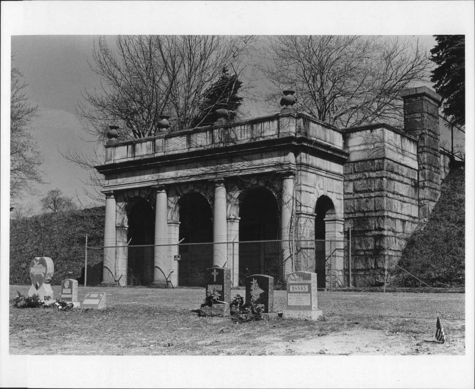
Several service structures stand in the North Burial Ground. Justnorth of the main entrance, a small stone vernacular Romanesquebuilding constructed in 1883 serves as the cemete’ry office. Northeast ofthe office is the large greenhouse built in the 1930’s. The most
____
impressive service structure is the monumental stone receiving tomb kbuilt into the western slopeof the southern plateau. Designed by theProvidence architectural firm Martin and Hall, the Beaux-Arts tomb wasfinished in 1904. The portico is an arcade three bays wide and one baydeep defined by engaged columns; both the heavily-rusticated walls
See continuation Sheet ‘HA * ‘
GPO 892 455
&-j
. 3

‘or-rn No, 1 O-300o11ev, 10.741 - - -
UNI’I’EI, SI’AFES IILP,R’FMENi’ Oil lIE INFERIOR FOR NE’S USE ONLYNATIONAL PARK SERVICE
RECEIVED ‘
NATIONAL REGISTER OF HISTORIC PLACES ‘. ‘ ‘
INVENTORY-- NOMINATION FORM DATE ENTERED -
CONTI NUATION SHEET 4 ITEM NUMBER 7 PAGE 5
and the ‘arcade carry a fully-articulated attic. West of the receivingtomb is the modern cinder-block maintenance building. Just to itswest, overlooking Interstate Highway 95, is a modest five-bay, one-and-a-half story, flank-gable, clapboard Greek Revival house with a one-story ell at the rear. This building was acquired by the cemetery inthe 1840’s,’and until recently it has been used as the superintendent’shouse. ‘ ‘
The condition of the cemetery varies, the more modern areas beingthe better maintained. Maintenance is at best haphazard, and poormaintenance, damage by weathering, and vandalism have abetted the general deterioration of the cemetery. Plans by the Providence ParkCommission to refurbish the North Burial Ground, however, promise tomake the visual quality of the cemetery commensuratewith its histor
_____
ical value. ‘ ‘
- GPO 892455

QSIGNIFICANCE -
PERIOD ‘ AREAS OF SIGNIFICANCE-- CHECK ANDJUSTIFY BELOW,,,PREHrSTORIC ARCHEQLUGY-PREFIISTORIC _,COMMUNITY PLANNING _LANDSCAPC ARCHITECTURE RELIGION
._1400-1499 _ARCHE0LOGV-HISTORIC _CONSEHVATION _LAW , SCIENCE
_____
500-1599 AGRICULTURE _ECONOMICS LITEHATUHE ‘ &SCULPTURE ‘‘
i6O0-l699 _ARCHITECTURE _EDUCATION _MILITARV S0CIA1JHUMAr4ITARIAN .
Xi 700-1799 AHT _ENGINEEHING _MUSIC _THEATER
CiB00-1899 _COMMERCE ,,EXPLORATION/SETTLEMEF4T _PHILOSOPHV ,THANSPOHTATION ‘
X1900- _COMMUNICATIONS ‘ JNDUSTRV _POLITICS/GOVERNMENT _OTHER SPECIFY
,_INVENTION
SPECIFIC DATES , BUILDER/ARCHITECT
STATEMENT OF SIGNIFICANCE ‘
The North Burial Ground, founded in 1700, is the oldest comrionburial ground in Providence and the earliest extant example of Providencecivic institutions. The cemetery has always operated under the auspicesof local government, and reflects the growth and change in, the socialand humanitarian attitudes that are so completely interwoven with anycivic history. Further, the cemetery contains many fine examples ofeighteenth- and nineteenth-century gravestones, includingseveral,byprominent’Rhode Island stonecutters.
Unlike other colonists in New England, the founders of Providenceinsisted :on a complete separation of church and state. While others inNew England ‘followed the English custom of locating their burial groundsadj acent to their churches, no church- - and hence no churchyard- -was constructed for the first sixty or so years after the settling of Providence. Consequently, burial p’lots were located on family house lots.All, but one of these private cemeteries have since been dc-activated asa result of development pressures on land in the compact settlement area.Only the Tillinghast lot near the intersection of Transit and BenefitStreets remains.
Toward the end of the seventeenth century, the First Baptist Societyundertook the construction of the first meeting house in Providence atthe present intersection of North Main and Smith Streets, but no landwas set aside for burials.
In 1700, the town meeting saw fit to set aside a common ground forpublic use as a military training field and burial ground. - The locationof the Common ground at the northernmost part of town, outside the compact section, indicates both increased development pressures on morecentrally located land and the Continuing separatist religious viewsof Providence citizens.‘ 1’ --
The original tract of land Contained about forty-five acres, ‘ofwhich only ten were designated for burials. The land was consideredgenerally unfit for any more productive use because of large’sanddeposits along the Moshassuck River at the tract’s western boi-der.
See’continuatioxj Sheet #5

Form No. 10’30baHey. lQ-?41 -
- UN1llil, STAlLS DEPARlMENFOI"’I’ Ilk IN’lIiIIOI - ‘
NATIONAL PARK SERVICE
NATIONAL REGISTER OF HISTORIC PLACES -
INVENTORY ..- NOMINATION FORM
CONTINUATION SHEET 6 ITEM NUMBER 5 PAGE 2
The setting aside of the common burying ground had little immediateeffect, and many families continued to use their private lots. Thefirst interment, that of a body of Samuel Whipple, did not take placeuntil 1710/11, and he was probably buried here becausehe lived immediately adjacent to ‘the grounds. By the 1720’s however, the cemeterygained.more general acceptance,and burials increased. ‘
From its inception, the North Burial .Ground has functioned as acommon burying ground in the fullest sense of the word. The independence and egalitarianism that characterized the early settlement ofProvidence was reflected in the North Burial Ground, which has always ‘
_____
been open to all. The oldest section of the cemetery demonstrates thisegalitarian spirit in its racial and social integration: graves ofearly black servants are interpolated with those of white citizens, andlaborers lie next to the wealthy proprietors of Providence. For example,the graves of the black Revolutionary War soldier Charles Haskell andhis wife Lucy ‘are adjacent to those of the prominent Brown and Angellfamilies. Their handsome slate Federal stones were carved by theTingley shop. Unlike the Common Burying-Ground in Newport, a separate
____
section was not set aside for slaves. ‘
As the population of Providence increased in the eighteenth centuryand settlement east of Town Street now Main Street became denser, theuse of small family lots became less practicable. The very real needfor the common burial ground was emphasizedwhen the North Burial Groundbecame part of the Town of North Providence in the partition of 1765.Negotiations to return the North Burial Ground to Providence began ‘
almost immediately, and were concluded in 1767 when the cemetery onceagain became part of Providence.
.
Throughout the eighteenth and early part of the nineteenth century,few changes were made in the common ground other than small, occasionaladditions of land to. the burial ground, such as the purchase ofeight ‘
acres from Moses Brown in 1796... -:
By the time Providence was chartered as a city in 1832, the lackof any comprehensive planning -for the North Burial Ground had become ,
_____
readily apparent in its ad hoc arrangement and maintenance. The firstmayor of Providence, Samuel W. Bridgham, found the cemetery in a. shabby ‘ 4state, and’made it one of his goals to improve the general condition
‘7
See continuation Sheet #7
GPO BOa 455 . ‘ 1-’"
ic
FOR NPS USE ONLY
RECEIVEO’
DATE ENTERED

form No, iO-aOOaHey, 1QflI
-- UNIFLI StAlES DIYAR1MLN’IoEI HE INrERIOR
NATIONAL PARK SERVICEFOR NI’S USE ONLY
AECEIVED.
DATE ENTERED’ , ‘‘ :‘
_______
p
PAGE 6
NATIONAL REGISTER OF HISTORIC PLACESINVENTORY-- NOMINATION FORM
CONTINUATION SHEET ITEM NUMBER
23
14
56 Pond7 Eskers8
Entrance LodgeElks StatueSarah Harris MarkerReceiving TombDried Pond
Caretakers Cottage
640
320
160
80$
GPo 892.455

Torm No, 1 0’300aHey, 10-741
- UNITED STATES DEI’ARTMENTOFTHE IN’I’ERIURNATIONAL PARK SERVICE
FORNPSUSEONLY‘ ‘.
RECEIVED: , ‘ ". ‘
DATE ENTERED’ ‘ ‘ ‘
NATIONAL REGISTER OF HISTORIC PLACESINVENTORY-- NOMINATION FORM
-
_
CONTINUATION SHEET 7 ITEM NUMBER 8 PAGE 3
of the grounds. As early as 1834 he began to agitate fo,r the plattingand fencing-in of the cemeteryJ The activity begun by Mayor Bridgham,who is buried in the cemetery, Came to fruition under his successor,Thomas M. Burgess. , Under his guidance, the governance of the cemeterywas re-organized in,1848 under the direction of a three-member commission,chosen annually. About this time, detailed regulations concerning interments, death certificates, and the supervision of undertakers werepromulgated.
Like most early American cemeteries, the North Burial Ground at itsinception -- aside from its function as a training field for militia --
_____
was simply a place to deposit the remains of the deceased. The conceptof the well-landscaped burial park was irrelevant to eighteenth-centurythought. The rural cemetery movement of the middle third of the nineteenth century, pioneered at Mount Auburn Cemetery in Cambridge, Massachusetts in 1831, had an almost immediate impact in Providence. ThomasC. Hartshorn, the founder of Swan Point Cemetery now npminated to theNational Register , called attention as early as 1840 to the desolate . Lcondition of local cemeteries. The North Burial Ground was prominent inhis’ thoughts. ilartshorn’s continuing zeal, which culminated in the
____
creation of Swan Point in 1846, no doubt influenced Mayor Burgess andthe City Council to’ take steps toward major improvements in the visualquality’of the North Burial Ground. Upon the petition of Zachariah Allen rtrand 256 other citizens, the City Council appointed a committee on 12thAugust 1844 "to devise and report some plan for improving the North BurialGround. . .and for ensuring the preservation of the Monuments erected ‘
theron."2 A report of the committee, comprised of Messrs Patten, Stimson,Peck and Alderman Knowles, dated 8th December fl45, noted that progresswas being made toward laying out "lanes and avenues for the Convenientuse of the Ground."3 The committee "also p1ace a valuation upon thelots which are of various dimensions and shape" and contracted for theconstruction of a fence to enclose the grounds. The impact’ of therural cemetery movement, which stressed spacious burlal parks, wasevident in the findings of the committee, which noted that
1T}ie Early Records of the Town of Providence, Printed under the Author- ‘_‘ -
ity of the City Counci,l of Providence Providence: Snow and Farnum,1904, V. 18, pp. 5860. :
2ibid, pp. l07-10&. . ‘
___
3ibid, pp. 111-115.
See continuation Sheet #8 ,
- GPO 892455
2 I -;
$‘-

form No 10- X04 ‘ ‘ .
-
iOe. 10-74 -‘
-- UNITED STAlES DEPAR’l’MENTOI-’’I’ I-IN IN’l’ERIORNATIONAL PARK SERVICE
NATIONAL REGISTER OF HISTORIC PLACESINVENTORY-- NOMINATION FORM
___
- CONTINUATION SHEET $ ITEM NUMBER 8 PAGE 4
the lots in the oldest section of the cemetery are- va’lued at the lowest rate of valuation, not because
these locations are less esteemedbut because the
____
Unmethodical manner in which it has been used andits crowded state leave but little opportunity forselection 9r satisfactory arrangement.4
____
Following the recommendation of the committee, extensive work beganon expanding and replatting the North Burial Ground. This work con- itinued into the 1850’s, and was carried out by the Providence surveyingfirm Atwater.and Schuharth. This firm was at the same time involved inthe design of Swan Point Cemetery, and the arrangement of the centralsection of the North Burial Ground reflects the same picturesque landscape concepts found at Swan Point. -
Concurrent with the refurbishing of the North Burial Ground was its TTT
considerable expansion to the north. While expansion in this direction -
was the greatest, parcels of land on all sides of the early common ground‘‘
were purchased from private landowners by the City in the middle years -
of the nineteenth century. In 1876, the City finally reached an agreement
____
with the heirs of William Randall concerning the strip of land immediatelyabutting North Main Street on the east side of the cemetery. Long thesite of the Randall family home, the area is known now as Randall Parkand is restricted to use as a landscape buffer in which no burials are
_____
permitted.
The civic nature of the North Burial Ground took on an added dimen- rr*sion in the second half of the nineteenth century. Beginning as early.as 1862, many group lots for civic organizations were established, including sections for the Masons, the Rhode Island Hospital, the GrandArmy of the Republic, the Home for Aged Men, the Benevolent ProtectiveOrder of Elks, the Providence Police Association, the Providence Association of Firemen for Mutual Assistance, the Home for Aged Colored Women,and Spanish-American War Veterans. This trend has continued into thiscentury with the setting aside of space ‘for mil:i.tary veterans and theclustering of several ethnic groups--Armenians are most prominent--in
-
the northern part of the grounds. The lots set off for these organiza-, -
tions have been marked with monumental sculpture that readily identifiesthe group, such as the large elk on the B.P.O.E. lot and the uniformed . -
fireman on the Association of Firemen lot.
4ibid, p. 113. . .-
See continuation Sheet #9 ‘ I
Gpo 892 455
FORNPSUSEONLY -
RECEIVED ,‘ H:’’
DATEENTEr.ED’ ‘

i’s
form N& 0-3fl0a . F -
Roy 10-741 .
UNll’Il S’FA’I’NS lFI’ARFMNN’IOl-’I’ III-: INI’ElIORNATIONAL PARK SERVICE -
Toward the end of the nineteenth century, the long history and thecivic importance of the North Burial Ground made it a desirable’sitefor the re-interment of bodies transferred from other cemeteries asthese sites were developed for other purposes. Remains formerly interredin private cemeteries on the original house lots were gradually moved -
_____
to the North Burial Ground as demands’for land on the East Side grewin the nineteenth century. A group of independent cemeteries collectivelyidentified as the West Burial Ground--located in the vicinity of Pointand Plain Streets today--was steadily de-attivated in the 1840’s. Thisprocess was completed in the 1890’s with the transfer of several hundred
____
unidentified bodies to the northernmost portion of the North BurialGround. In 1891, the bodies in the Hopkins family plot--except for thatof Admiral Esek Hopkins--at the intersection of Charles Street and BranchAvenue were removedto the North Burial Ground. The North Burial Groundbecame, as it were, the final resting place for the many small cemeterieslocated throughout Providence.
The turn of the twentieth century also marked a period of diligentcaretaking and improvements of the North Burial Ground. The planting Hefforts of mid-century came to fruition, ,and the tree-lined ,avenues androlling slopes were well-maintained. With the growth of the ‘Mount Hope -
neighborhood to the east, direct access from that direction became
_____
desirable,. and this was accomplished by the construction of the marblestaircase at the intersection of Cemetery and North Main Streets. The’physical, care c-f the cemetery was augmented by the increased historicalinterest in the cemetery at its bicentennial in 1900: a great deal, ofresearch was collated at this time, including the two volumes of theEarly Records of the Town of Providence, published in 1904, which weredevoted entirely to the history of the North Burial Ground.
-‘
--
/‘ -
- I,_-$-’ -
hi
See continuation Sheet It’D- GPO 092455
‘
Q’ -- _ffceJ;:r:T ;:-:
NATIONAL REGISTER OF HISTORIC PLACES- INVENTORY-- NOMINATION FORM
CONTINUATION SHEET 9 ITEM NUMBER
FOR NPS USE ONLY
RECEIVED
DATE ENTERED -
8 PAGE
______-
‘fly
a
During the Great Depression of the 1930’s the North Burial Groundbecame the focus of several Works Progress Admihistration projects.TWA workers were used to help maintain the cemetery grounds, and thecurrent greenhouse was erected to facilitate landscaping efforts.Toward the end off the decade, however, rising costs of labor and thereduction of the workforce abetted the deterioration of the ‘cemetery.Primarily to hinder the increasing decrepitude of the ground’s, theadministration of the cemetery was re-organized under the auspices ofthe Parks Commission in the early 1940’s. In spite of the Cothmission’ssupervision, howe-ver, gradual deterioration continued,’and vandalismincreased.

rotc, No, 10-3GOaRev 10-14
LINI1IjU Si’AIES DEI’ARI’MEN’F UI"] Ilk INI’ERIURNATIONAL PARK SERVICE
FORNPSUSE ONLY
‘
RECEIVED ‘
DATE ENTERED’ - .
The renascenceof civic spirit in Providence in the 1970’s has-once again,hrought the North Burial Ground to th,e attention of the City,and proposals for re-furbishing it are already in progress. To this end,the LAND/RISD North Burial Ground Study,published in September 1976,was dedicated. This document examines the history and physical characterof the grounds toda, and suggests actions to improve the physicalquality of the cemetery. Plans for the cemetery include a series ofwalking tours to focus public attention on the cemetery, restoration’ anddocumentation of the many early markers on the grounds, and restorationof the park-like atmosphere that characterized the park in the laternineteenth century.
Not only is the North Burial Ground itself a chronicle of socialand humanitarian attitudes, but it further contains the graves of anumber of Rhode Islanders important to civic and social history. Theseinclude Eheneezer Knight Dexter, benefactor of the Dexter Asylum 1830,John Holden Greene, architect; now demolished and the Dexter ParadeGround now 1istec on the National Register ; Nicholas Brown, a founder-of
VBrown University; Cyrus Butler, benefactor of Butler Hospital and theProvidence Arcade both listed on the National Register ; Francis
____
Wayland, president of Brown University from 1827 to 1855; and HoraceMann, the prominent American educator. Military leaders buried in the ,
cemetery include Captain Israel Angell, off Revolutionary War fame, and. -
Charles Haskell, a black Revolutionary War soldier. Six Rhode IslandGovernors are buried at North Burial Ground: Stephen Hopkins 1755-1757 ,
1758-1762, 1763-1765, 1767-1768, Nicholas Cook 1775-1778, ArthurFenner 1790-1805, James Fenner 1807-1811, 1824-1851, John Brown ‘
Francis 1833-1858, Charles Jackson1845-1846, and Philip Allen -
1851-1853. As well as Mayor Bridgham 1832-1840, two other mayorsof Providence are interred in the North Burial Ground, Thomas MackieBurgess 1841-1852, Bridgham’s successor, and Edward Peck Knowles1854-1855. ‘
‘
1*
See continuation Sheet‘#11- GPO 892, 455
‘r-:t,_>v.’7;’ ‘t- - ,---. ‘ - - - .-,-‘- ‘ - - .. ‘‘.r ‘-
NATIONAL REGISTER OF HISTORIC PLACESINVENTORY-- NOMINATION FORM
CONTINUATION SHEET . 10 ITEM NUMBER 8 PAGE 6
The North Burial Ground is further noteworthy for its numerousexamples of eighteenth- and early nineteenth-century gravestones. Withinthe oldest section of the grounds are slate markers produced by some ofthe best-known shops in Rhode Tslnnd
While Providence seems not to have had a stonecarving shop until theearly years of the nineteenth century, nearby towns had several activeshops which-provided Providence citizens with gravestones. Research hasyet to shed light on the work of John Anthony Angeli, a residdnt of

Form No, O-3OOa --
nov. 1014 -
UNITLI StArES DLLPARTMENroI: T lIE INI’ILRIOR FOR NPS USE ONLY ‘ -
NATIONAL PARK SERVICE -. ‘ ‘ -. - ‘, ‘ ‘ -
RECEIVED
NATIONAL REGISTER OF HISTORIC PLACESINVENTORY-- NOMINATION FORM , DATE ENTERED :..: L.
-. -
-
___
CONTI NLJATION SHEET 11 ITEM NUMBER 8 PAGE 7
Providence who, was listed as a stonecutter at the time of his death in1756. The Tingley shop was active in Att.leboro throughout the eighteenth
____:
century before it moved to Providence in 1811. Newport, which had itsown stonecutter as early as 1705, also produced stones in the NorthBurial Ground, including some handsomework by the John Stevens shop.
____
The gravestones in the North Burial Ground include many of thestandard eighteenth-century types. For example, the metaphorical repre-sentation of the passage of time, the scythe and hourglass, which wasquite popular in the eighteenth-century Rhode Island, is represented inthe North Burial Ground by the Mary Harris marker of 1744; unlike other -
representations of this theme, however, the scythe only touches but doesnot split the hourglass. The Mary Harris stone and the nearby Sarah,William, and Job Harris stones are all the work of the Stevens shop inNewport, probably carved by John Stevens II. This latter group of stonesis fascinating for the design virtuosity produced by the Stevens shop.On the Sarah Harris marker of 1723, the shield of the family coat ofarms is carved at the top of the marker; on the William Harris stone1725 and the Job Harris stone 1729 , Stevens had liberated the three
____
birds on the shiei,d from their strictly vertical arrangement and placed -:them in a triangular arrangement on a ruited vine; the heraldic familysymbol was thus transformed into an iconographic theme representativeof a happier existence in the hereafter.S The Chad Brown stone of 1792,which replaced an earlier stone, uses the. sun as its main motif at thetop; scholars are uncertain whether this use represents the sun as asoul-sun effigy or is more simply an emblem of the Resurrection.6 TheSarah Antram stone of 1732 shows a very sophisticated handling of theoften used theme of a host of angels escorting the soul to heaven: itscomposition is heavily dependent on harque assumption formulae, andthe carving surpassesthe ,enerally flat treatment common on tombstonesefthis period, moving toward a more fully developed three dimensionality. i’4
The long history of the North Burial Ground, the high qiiality of,,,its I.Ceighteenth-century markers, and the intention of the City of Providenceto commit funding for preservation of the oldest civic institution andone of the largest remaining open spaces in the City make its recogni-tion by the National Register essential at this time. ‘ . -
____
5Allen I. Ludwig, Graven aes Middletown: Wesleyan University Press,1966, p.°Harriette M. Forbes Gravestones’ of Early New England Boston HaughtonMifflin, 1927, p. - - , - -
-
-- GPO 9Z S5

rorm No. 1 0-300a
Rev, 10-74
UNITED SlAtES DEI’AR’rMEN’r UI- ‘Fl-IL INFERIOR FORNPS USE ONLY - - -
NATIONAL PARK SERVICERECEIVED - - -
NATIONAL REGISTER OF HISTORIC PLACES - - - -. - - --
INVENTORY-- NOMINATION FORM, DATE-ENTERED ‘-
CONTINUATIONSHEET 12 ITEM.NUMBER 9 PAGE 2
Books cont
Dorr, Henry C. The Planting and Growth of Providence. Providence,1882. ‘pgs. 8, -41, 46, 47, 238.
The Early Records of the Town of Providence. Printed under theauthority of thCii7 Council of Providence. Providence: -Snow
and Farnum, 1904. - Volumes 18 and 19.Forbes, Harriette M. Gravestones of Early New England. Boston:
Houghton-Miffin Company, 1927. -
LAND/RTSD. North Burial Ground Study, Providence, Rhode Island.Providence, 1976. -
Ludwig, Allan I. Graven Images. Middletown: Wesleyan UniversityPress, 1966.
The North Burial Ground of the City of Providence. Providence:The Providence Press, Snow and Farnum, 1900. ,
Staples, William R. Annals of the Town of Providence. Providence:Knowles and Vose, 1843. pp. 184-185. -
Tashjian, Dickran Ann. Memorials for Children of Change’Middletown: Wesleyan University Press, 1974. pp. 212-230. ‘
Periodicals- - - -
Brown, Sevellon. "Topic for Today: A Fresh Look at ‘Old North’."Providence Journal 2nd February 1964: Section N, p. 30.
Commissioners of the North Burial Ground. Annual Report. ‘1899-1907."North Burial Ground’s Public Memorials." Providence SundayJournal 26th May 1912: Section 5, p. TU."The Old North Burial Ground." Providence Sunday Telegram-22nd October 1899: pgs. 9-12. -
_______ _______-
Sherman, James L. "The Story of the Tablets." NarragansettHistorical Register Volume 4, Number -1 - Volume 7NnBErTJITl8 -January 1887 .
Interviews -
Edwin C. Connelly. Private interview held at the North ButiàlGround. 28th December 1976. - - .
UI! 892 1554.

‘5 -
-
- flMAJOR BIBLIOGRAPHiCAL REFERENCESBoos
__________
County. New York:1, pp. 288-290. -
and Architectural DevelopmentThe Book Shop, 195/. pgs. 19
#11
GEOGRAPHICAL DATA - - -
ACREAGE OF NOMINATED PROPERTY 1 50 acres : -
UTM REFERENCES E 19 ‘299690 4635530
Al 1191 1310,01l,J1 6 36l ] .0J BIl, 91 1310,013,6,01 14 6JJ3 ,5I8l9LOjZONE EASTING NORTHING ZONE EASTING - NORTHING
Ci l3I010I4,0_jj l6’i3,SiS,9,0j 011191 1310,01014101 1416131418,210- VERBAL BOUNDARY DESCRIPTION -
tJST ALL STATES AND COUNTIES FOR PROPERTIES OVERLAPPING STATE OR COUNTY BOUNDARIES
STATE - CODE COUNTY CODE
STATE - CODE COUNTY CODE
mFORM PREPARED BYNAME / TITLE
Win. -McKenzie WoodwardORGANIZATION DATE
Rhode Island Historical Preservation Commission Feb. 1977STREET & NUMBER ‘ TELEPHONE , -
150 Benefit Street 401-277-2678CITY OR TOWN STATE
Providence Rhode Island
mSTATE HISTORIC PRESERVATION OFFICER CERTIFICATIONTHE EVALUATED SIGNIFICANCE OF THIS PROPERTY WITHIN THE STATE IS:
NATIONAL........ STATE....X... LOCAL...... -
As the designated State Historic Preservation Officer for the National Historic Preservat,on Act of 1966 Public Law 89-665.ihereby nominate this property for inclusion In th National Register and certify that it has been evaluated according to thecriteria and procedures set forth by the Natio al Par Servic
rir’ttFEDERAL REPnESENTATIVE SIGNATURE I _t LLE.- - ,"3.. . M1 Q-.
TITLE State Historic Preservation Officer’ - DATE June 17, 1977FOR NPS USE ONLY -- -
I HEREBY CERTIFY THATTHIS PROPERTY IS INCLUDED IN THE NATIONAL REGISTER
- DAlEDIRECTOR OFFICE OF ARCHEOLOGY AND HISTORIC PRESERVATION
ATTEST: DATE
KEEPER OFTHE NATIONAL REGISTER - - -
______
Bayles, Richard N. Hist’oty of ProvidenceW. W. Preston, 18TTVlume
Cady, John Hutchins. The Civicof Providence. Proviffence:65, 148, 149, 160, 269
59,en rnntiniii-tinri choral-

DV c-t


I *

NORTH BURIAL GROUNDPROVIDENCE, RHODE ISLAND
Photographer: Wfl Mckenzie Woodward
Date: December 1976
Negative; Rhode Island Historical PreservationCommission
Gatehou5e
-

NORTI I BURIAL GROUNDPROVIDENCE, RHODE ISIAD
Photographer: wm MKenzio Woodward
Date: December 1976
Negative: Rhode Island Fltstorical Preservation Commission
Receiving Tomb, view from the 3outhwest

* .*
-
NORTH BURIAL GROtJIJD
PROVIDENCE, R}iOrj ISLAND
Photograther: W McKenzie Woodward
Date: December 1976
Negative: Rhode Island Historical Preservation Comrriision
Sarah Harris Stone

2/
-
I

NORTH BURIAL GROUNDPROVIDENCE, RHODE ISLAND.
Photographer: Wm McKenzie Woodward
Date: December 1976
Negative: Rhode Island Historical PreservationCommission
Victorian Bridge, view from southeast

O1
PROVIDENCE QUADRANGLERHODE ISLAND
7.5 MINUTE SERIES TOPOGRAPHICBOSTON MASS 40 Mi
SOUrHA TTLEORO, M4SS. 2.2 M 71 0223O53000 FEET 41052.:
NORTH BURIAL GROUNDPROVIDENCE, RHODE ISLANDA 19: 300120: 4636130B 19: 300360: 4635890C 19: 300400: 4635590D 19: 300040: 4634820E 19: 299690: 4635530
299 25’
4633
C’.-
oO
000