h. c. nutting company - marshall university
TRANSCRIPT

Corridor H Section 6 Mainline over South Branch Potomac River
Abutment No. 1 Site Inspection
State Project No. X316-H-100.40 04
Federal Project No. APD-0484(255)C
Hardy County, West Virginia
Cornerstoneof the Past -
DedicatedTo the Future
H. C. Nutting CompanyH. C. Nutting Company

Purpose
H. C. Nutting Personnel conducted a field inspection of the site as per request by the WVDOH and the FHWA.
The Purpose of the inspection was to try to verify the orientation of the joint system, fractures and more closely examine the condition of the high wall slope rising above the river in the vicinity below the proposed location of abutment 1.

Home on the Range

Moorefield Geology Profile

Original Proposed Design
Alternate 1

Original Proposed Design
Alternate 2

Original Proposed Design
Alternate 3 Early on - Considered the Design of Choice

Upper Slope Joint/Discontinuity
The surface is subjected to freezing and thawing cycles, and wet and dry cycles resulting in significant shallow spalling of the surface as evidenced by the accumulation of talus at the base of the slope.

Lower Slope Joints/Discontinuities
At the base of the slope, two measured joint sets were observed in the siltstone, which vary from 80° to near vertical.
The measured orientations of the joints are:
Joint Set 1 - 85° dip and 50°to 60° dip direction
Joint Set 2 - 80° to 88° dip and 320° to 335° dip direction

Small Scale Folding in Lower Slope
The Rock strata, although interrupted by some isolated, small scale folding and discontinuities has an approximate dip of 5 to 10 degrees from the horizontal in a southeasterly direction, with a strike of approximately 20 to 30 degrees in a northeasterly direction.

Small Scale Wedge Failure in Lower Slope
The risk for planar or block failure on a large scale does not appear to be a significant issue based upon the geometry of the rock strata.

Weathered Shale Slope
This type of erosion creates a very irregular slope that is subject to frequent pop outs resulting in some overhanging and weathered shale bluffs that appear to be at high risk of failing with a minimum effort of disturbance.

Undercutting & Overhanging of Shale Bluff

Width of Bench in Front of Abutment 1
South Edge of Abutment 1 to Edge of Slope is Approx. 65 ft.North Edge of Abutment 1 to Edge of Slope is Approx. 18’
Approx. 65’
Approx. 18’

Alluvial Terrace Deposits North Side of Abutment No. 1
The North Corner of the abutment is located near the contact of the discontinuity of the siltstone and extremely soft, brown, silty, clayey shale and alluvial terrace soil deposits.

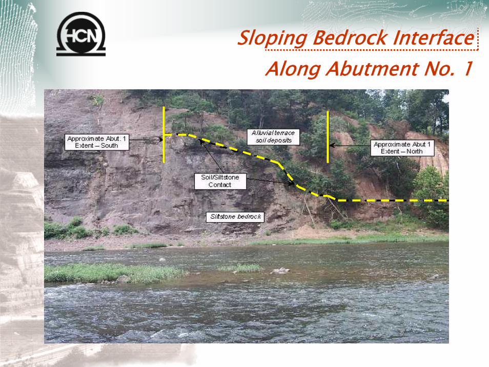
Sloping Bedrock Interface Along Abutment No. 1
The desired bedrock foundation at elevation 846.0 is not consistent for the full width of the abutment as observed by visual observation.

Summary of Field Investigation
•Recommendations by H. C. Nutting Company
•Review by the Prime Consultant
•Various Construction Alternatives
•Conclusion
Sloping Bedrock Interface Along Abutment No. 1

Proposed Plan ElevationFor Construction of Drilled Shafts

Wing Wall Details

Thank You
H. C. Nutting Company
H. C. Nutting CompanyH. C. Nutting Company
Questions