guildford borough strategic flood risk assessment final
TRANSCRIPT

Guildford Borough Strategic Flood Risk Assessment Volume 1 Final Decision Support Document July 2016

Guildford Borough Level 1 SFRA
1
Quality Management
Job No CS074594
Project Guildford Borough SFRA Update
Location G:\environment\ZWET\CS074594_Guildford_SFRA_update\Reports and Outputs
Title Volume 1 – Decision Support Document
Document Ref Guildford Borough SFRA Report Volume 1 Decision Support Document
Issue / Revision Final
Date July 2016
Prepared by 1 Hayley Todd Signature (for file)
Prepared by 2 Georgia Athanasia Signature (for file)
Checked by Louise Markose Signature (for file)
Authorised by Kerry Foster Signature (for file)
Revision Status / History
Rev Date Issue / Purpose/ Comment Prepared Checked Authorised
1 07/11/2014 Draft for Submission to GBC and EA GA LM MA
1.1 20/02/2015 Final Draft Submission GA / HT LM MA
1.2 24/07/2015 Final Submission HT LM LM
1.3 25/09/2015 Final Submission GA LM LM
1.4 26/01/2016 Final Submission GA LM LM
1.5 22/06/2016 Final Submission GA NS NS

Guildford Borough Level 1 SFRA
2
This document is the property of Guildford Borough Council (GBC). If you have received it in error, please
return it immediately to the above named Local Authority.
This report has been prepared by Capita Property and Infrastructure Limited with all reasonable skill, care and diligence within the terms of the Contract with the Client, incorporating our General Terms and Conditions of Business and taking account of the resources devoted to it by agreement with the client. We disclaim any responsibility to the client and others in respect of any matters outside the scope of the above. This report is confidential to the client and we accept no responsibility of whatsoever nature to third parties to whom this report, or any part thereof, is made known. Any such party relies on the report at their own risk.

Guildford Borough Level 1 SFRA
3
Executive Summary
Guildford Borough Council (GBC) is currently producing their Local Plan and this Strategic Flood Risk
Assessment (SFRA) will form a key evidence base to support the vision and approach to development
over the plan period. This document has been prepared in response to the guidance in National
Planning Policy Framework (NPPF) and its Planning Practice Guidance (PPG) that states that a
sequential risk based approach should be applied to decision making at all levels of the planning process.
The principle stages being the Local Level (this assessment) and the site level (planning applications).
The SFRA creates a strategic framework for the consideration of flood risk when making planning
decisions at the Local Level.
The fundamental concepts that underpin the SFRA are outlined in the NPPF. The guidance provided in
the NPPF requires local authorities and those responsible for development decisions to demonstrate that
they have applied a risk based, sequential approach in preparing development plans and that they have
considered flooding through the application of a Sequential Test. Failure to demonstrate that such a test
has been undertaken at this level potentially leaves planning decisions and land allocations open
to challenge during the planning process.
The underlying objective of the risk based sequential allocation of land is to reduce the exposure of new
development to flooding and reduce the reliance on long-term maintenance of built flood defences. Within
areas at risk from flooding, it is expected that development proposals will contribute to a reduction in the
magnitude of the flood risk.
SFRAs are essential to enable a strategic and proactive approach to be applied to flood risk
management. The assessment allows us to understand current flood risk on a wide-spatial scale and how
this is likely to change in the future.
The main objectives of Guildford Borough SFRA are to provide flood information
• As the evidence base for the application of the risk based Sequential Test to support planning decisions, in line with NPPF;
• That is strategic in that it covers a wide spatial area and looks at flood risk today and in the future;
• That supports sustainability appraisals of the draft Local Plan; and
• That identifies what further investigations may be required in flood risk assessments for specific development proposals.
The SFRA is presented in a number of documents:
• VOLUME 1 – Decision Support Document (this document);
• VOLUME 2 – Technical Report; and
• VOLUME 3 – Mapping.
A short summary document has also been produced, presenting the key elements of Volumes 1 and 2.
The SFRA is a live document that is intended to be updated as new information and guidance become available. The outcomes and conclusions of the SFRA may not be valid in the event of future changes to t h e d a t a or the baseline flooding situation. Decisions also require the inclusive assessment of wider planning issues and the user should be aware that changes to decision making principles affecting other planning issues can potentially affect the outcome of the risk based Sequential Test. It is the responsibility of the user to ensure they are using the best available information.

Guildford Borough Level 1 SFRA
4
Document register
It is accepted that the technical content of Guildford Borough SFRA will need to be reviewed and
amended as new information becomes available.
It is the responsibility of the reader to be satisfied that they are using the most up to date information and
that this has been included within Guildford Borough SFRA.
The Guildford Borough SFRA (this document) is a live document requiring review in the event of an improvement or change in the fundamental principles or best available data underpinning the strategy.
Guildford Borough Level 1 SFRA
5
Contents Executive Summary 3
Document register 4
1. Introduction 7 1.1 Background 7 1.2 SFRA Objectives 8
2. Flooding In Guildford Borough 10 2.1 Description of Study Area 10 2.2 Sources of Flooding 11 2.3 Historic flooding 12 2.4 Probability of flooding 12 2.5 Flood Risk Maps 13 2.6 Flood Zone 3b, the Functional Floodplain 14
3. Roles and Responsibilities 16 3.1 Role and Responsibilities 16 3.2 European Policies (EU) 19 3.3 National Policies 20 3.4 Other Relevant Policy 22 3.5 Local Policies and Guidance 22 3.6 Environment Agency Guidance 25
4. Guidance on Applying the Sequential Test 26 4.1 What is the Sequential Test? 26 4.2 How should the SFRA be used to apply the Sequential Test? 31 4.3 Additional Guidance 32
5. Guidance on Applying the NPPF Exception Test 34 5.1 What is the Exception Test? 34 5.2 What is required to pass the Exception Test? 34
6. Guidance on How to Use the SFRA in Development Control37 6.1 Guide to Volume 3 – Contents relevant to Development Control 37 6.2 Guidance for site-specific flood risk assessments 37 6.3 A Guide for Developers 37
7. SFRA Maintenance and Management 39 7.1 Introduction 39 7.2 Data Collection 39 7.3 Data Processing 39 7.4 Data Ownership 40 7.5 SFRA data management system 40 7.6 Monitoring the SFRA 41 7.7 Incorporating new datasets 42 7.8 Updating SFRA reports and figures 42
8. Future Flood Risk Management Practices 44 8.1 Strategic Flood Defences and Maintenance 44
9. Drainage of Development Sites 47 9.1 Background 47 9.2 What are SuDS? 47 9.3 SuDS Policies 48
10. Policy Considerations 50
11. Site Specific Flood Risk Assessment Guidance 52

Guildford Borough Level 1 SFRA
6
11.1 When are Flood Risk Assessments Required? 53 11.2 Flood Risk Assessments Requirements 54
12. Emergency Planning 56 12.1 Developing an Emergency Flood Plan 56 12.2 Use of the Emergency Plan in the Planning System 56
13. Other Possible Users of the SFRA 58
14. Conclusions and Recommendations 59 14.1 Conclusions 59 14.2 The Next Stage 59 14.3 Recommendations 59 14.4 When should the SFRA be updated 60
15. References 61
16. Glossary and Notation 62
Figures Figure 2-1: Guildford Borough Study Area 10 Figure 2-2 – Flood Zone 3b developed and undeveloped 15 Figure 4-1 – An Application of the Sequential Test for Local Plan preparation (PPG
Flood Risk and Coastal Change) 27 Figure 5-1: An Application of the Exception Test for Local Plan preparation (PPG
Flood Risk and Coastal Change) 35 Figure 7-1: SFRA Data management System 41
Tables Table 2-1: Fluvial flood events considered in this SFRA 13
Table 4-1 – Flood Risk Vulnerability Classifications 28
Table 4-2 – Flood Risk Vulnerability Classifications and flood zone ‘compatibility’
29
Table 4-3: Template table for recording Sequential Test process 30
Table 4-4: Guidance for GBC on the use of this SFRA in the application of the
Sequential Test 32
Table 5-1: Guidance for GBC on the use of this SFRA in the application of the
Exception Test 35
Table 7-1: Datasets that are known to be updated regularly 42
Table 10-1: SFRA Policy Considerations 51
Appendices Appendix A Data Document Register

Guildford Borough Level 1 SFRA
7
1. Introduction
1.1 Background
The 2009 Level 1 Strategic Flood Risk Assessment (SFRA) was carried out on behalf of GBC. The information in
the 2009 Strategic Flood Risk Assessment (SFRA) was used to inform the Local Development Framework (LDF).
The 20 09 SFRA a ls o provided information required to apply the Sequential Approach and Sequential Test
on the Local Development Document scale. The SFRA was developed in line with the now superseded Planning
Policy Statement 25 – Development and Flood Risk (PPS25) (DCLG, 2006)1.
Capita Property and Infrastructure were commissioned in June 2014 to update the Level 1 SFRA document. This
updated decision support document provides information on how to interpret Guildford Borough SFRA results to
inform land use planning, flood warning and emergency planning and development control. The document also
provides guidance for site-specific Flood Risk Assessment (FRA). The document requires the user to refer to
technical information and flood maps contained in Volumes 2 and 3 of this SFRA.
The 2009 SFRA was largely retained however several updates and reviews were carried out. The following
summarises the scope of works for this updated document:-
Identify policy updates since 2009 in particular the introduction of National Planning Policy Framework
(NPPF)2 and the Planning Practice Guidance (PPG) for Flood Risk and Coastal Change
3;
Review any post 2009 flood incident data;
Identify updates related to new datasets, including Guildford Surface Water Management Plan (SWMP),
the Updated Flood Map for Surface Water (UFMfSW) and the risk from groundwater flooding; and
Provide recommendation for general principles for flood risk management including a review of GBC Flood
Risk Reduction Measures document.
The release of Planning Policy Statement 25: Development and Flood Risk in December 2006 (PPS25) (DCLG,
2006) emphasised the responsibility that Local Planning Authorities (LPAs) have to ensure that flood risk is
understood and managed effectively using a risk-based approach as an integral part of the strategic planning
process. PPS25 encouraged LPAs to undertake SFRAs and to use their findings and those of other studies to
inform strategic land use planning. The National Planning Policy Framework (NPPF) document replaced the suite
of Planning Policy Statements, including PPS25, on 27 March 2012.
NPPF states “A Strategic Flood Risk Assessment is a study carried out by one or more planning authorities to
assess the risk to an area from flooding from all sources, now and in the future, taking account of climate change,
and to assess the impact that changes or development in the area will have on flood risk”.
The NPPF and its accompanying PPG maintain the requirement to apply a risk-based, sequential approach to the
location of development in order to avoid flood risk to people and property. The key difference for flood risk policy
compared to PPS25 is that the NPPF gives local authorities a wider remit to interpret and implement local policies.
This makes the SFRA process all the more important in establishing suitable, reasonable and practical local
development policies to manage local flood risk. Refer to Chapter 3 of this document for further discussion on the
introduction of NPPF and its implications for the management of flood risk.
PPG Flood Risk and Coastal Change recommends that SFRAs are completed in two consecutive stages. This
provides the LPA with tools throughout the Local Plan and SFRA process sufficient to inform decisions regarding
development sites. The two stages are: -
Level 1 SFRA – Study Area Flood Source Review and Sequential Test
Level 2 SFRA – Development Site Assessments for Exception Testing.
1 Planning Policy Statement 25: Development and Flood Risk, March 2010.
2 National Planning Policy Framework, March 2012
3 Planning Practice Guidance Flood Risk and Coastal Change, March 2014

Guildford Borough Level 1 SFRA
8
The results of the Level 1 SFRA should enable GBC to clearly identify where development is appropriate
according to NPPF and where development is necessary. A level 1 SFRA must be used to inform and shape the
forthcoming local plan strategy and policies. The Level 1 SFRA should therefore enable a prompt start to the
commencement of Level 2 (where required). The data review element of Level 1 also enables a robust
specification and programme to be developed for a Level 2 SFRA. At the time of writing GBC is preparing a new
Local Plan which will set out the vision and approach to development between now and 2031. Following
completion of level 1 SFRA it is anticipated that GBC will be in a position to understand if there is a requirement to
undertake a Level 2 SFRA. This will be supported by the findings of this Level 1 SFRA, which contains up to date
modelling to enable a better understanding of the flood risk across the borough.
1.1.1 Level 1 – Area Flood Source Review and Sequential Test
A Level 1 SFRA presents sufficient information to enable the LPA to apply the Sequential Test to potential
development sites and assists in identifying if application of the Exception Test will be necessary. The Level 1
SFRA also provides background information, a review of local policies, and guidance for site specific flood risk
assessment and the potential for application of Sustainable Drainage Systems (SuDS). The review of policies is
allied to guidance on the requirements for site-specific Flood Risk Assessments (FRAs) throughout the study area.
The outcomes from the Level 1 SFRA should be used by the LPA to identify the most suitable locations for
development in line with NPPF and other planning drivers. A Level 2 SFRA will be needed if the level 1 SFRA and
the sequential test shows that land outside flood risk areas cannot appropriately accommodate all the necessary
development. This report presents the information generated during Level 1 of the SFRA. The Level 1 SFRA is
based on existing published information held by local stakeholders..
1.1.2 Aim of the SFRA
The aim of Guildford Borough Level 1 SFRA is to present sufficient information in the form of a robust evidence
base to enable GBC to apply the Sequential Test to all site allocations. In addition the SFRA should form a
reference document for use by development control officers for advising and determining decisions on windfall and
allocated sites.
To assist GBC in understanding the flood risk posed to developments in areas at risk, a level 2 SFRA may be
required to provide more detailed flood risk evidence for sites identified as potential allocations. It should present
sufficient information to assist in determining if proposed developments will be safe from the risks of flooding for
their lifetime.
1.2 SFRA Objectives
In keeping with guidance presented in the NPPF and its accompanying Planning Practice Guidance (PPG), the
objectives of Guildford Borough Level 1 SFRA are:
1. Identify the extent of all Flood Zones;
2. Identify areas at risk of flooding from all flood sources present in the study area, providing GBC with the tools required to apply the Sequential Test;
3. Provide evidence-based report which inform GBC’s Local Plan and other Development Plan Documents about managing potential flood risk which are also suitable to inform the Sustainability Appraisal of related documents;
4. Advise GBC on suitable policies to address flood risk management in a consistent manner across its administrative area;
5. Advise GBC on the requirements of site specific flood risk assessments based on local conditions and policy considerations;
6. Advise GBC on the principles, objectives and applicability of Sustainable Drainage Systems (SuDS) throughout the study area; and
7. Present information to inform GBC of the flood considerations necessary in developing and progressing flood emergency planning.

Guildford Borough Level 1 SFRA
9
Note that the above objectives have not changed and remain the same (updated to account for policy changes) as
the 2009 Level 1 SFRA. The potential impact of growth on future flood risk is a key driver for preparation of the
SFRA and to provide a consistent and robust evidence base for assessment of new development.

Guildford Borough Level 1 SFRA
10
2. Flooding In Guildford Borough
2.1 Description of Study Area
The Guildford Borough SFRA covers the whole of GBC’s administrative area, in South East England. Guildford borough is situated approximately 50 km (31 miles) southwest of London. Within the study area the principle fluvial watercourse is the River Wey and its tributaries. The study area includes the Wey Navigation, which is a combination of navigable river and manmade sections maintained by the National Trust and the Basingstoke Canal, which is managed and owned by the Basingstoke Canal Authority and used mainly by leisure boats. The River Blackwater flows along the western boundary of the study area.
Figure 2-1: Guildford Borough Study Area
Catchment Area
The River Wey has a total catchment area of 904km2, draining parts of Surrey, Hampshire and West Sussex. It
joins the River Thames between Hamm Court and Whittets Ait facing a weirstream of Shepperton Lock. It is
navigable from Godalming to its confluence as part of the Wey and Godalming Navigations. The main sub-tributary
is the Tilling Bourne flowing from the western slopes of Leith Hill in Surrey westwards to a point just south of
Guildford between the main village of Shalford and its Peasmarsh locality. Downstream the river forms the
backdrop to Newark Priory and Brooklands.

Guildford Borough Level 1 SFRA
11
The River Blackwater and its major tributaries, the Whitewater, Hart and Fleet Brook, together have a catchment
area of approximately 360km2. It partially marks the western boundary of Guildford Borough. The Blackwater
Valley is fairly heavily urbanised. The source of the Blackwater is at Runfold just south of Aldershot, at Rowhill
Nature Reserve. There are no major tributaries which join the Blackwater within the study area.
Topography / Geology
The topography is quite variable to the south of the study area where the edges of the South Downs are located.
Notable areas of higher ground such as the topographic ridge of the Hogs Back can be found in the north the
study area. Through this landscape the River Wey and the Blackwater have cut south-north valleys which are well
defined topographically and especially on the River Wey the river floodplain is well developed.
In the Wey Valley the meandering floodplain increases in width as it moves northwards. Generally the floodplain
reduces in width where the river flows through the urban areas. Upstream, in Guildford the floodplain is
approximately 250m wide.
The geology of Guildford borough is characterised by three main rock types, Lower Greensand formation in the
south, typically sandstone of varying character and Weald Clay to the far south east corner. Overlying the
Greensand is a thin band of Chalk which runs east-west through the study area. To the north of this the geology is
dominated by the London Clay. The Chalk and the Greensand are relatively permeable rock types which are the
most likely to be a source of groundwater flooding. The London Clay is very impermeable and water is unlikely to
soak into the ground easily in areas underlain by London (or Weald) clay. To the west towards the river
Blackwater, the catchment geology mainly consists of Bracklesham Beds sandstone (which overlie the Bagshot
Beds), overlaid by patches of Barton Sand in Farnborough and Aldershot.
In both the Wey and the Blackwater Valleys there are significant deposits of geologically recent river gravels which
may have locally perched water tables within them.
Overland Flow
Areas of steep ground have the potential to generate runoff which can present a flood source. The steep
topography in parts of the study area may present a flood source to areas down slope of them.
Artificial Sources
Artificial sources include reservoirs, canals and lakes where water is retained above natural ground level and
operational and redundant industrial processes including mining, quarrying and sand and gravel extraction.
Guildford borough is at risk of flooding from three reservoirs based on the reservoir inundation maps as shown in
Figure 9 in Volume 3. However, only one reservoir - the Clandon Park reservoir - is located within Guildford
borough boundary. The Vachery Pond, located south of Guildford, owned by Cook, the Sutton Place Lake owed by
Knight Frank and the Clandon Park owned by Onslow both located north of Guildford.
2.2 Sources of Flooding
SFRA’s are used to refine information on areas that may flood, taking into account flooding from rivers and all
other sources of flooding and the impacts of climate change, in addition to information on the Flood Map (NPPF,
2012). Volume 2 of this SFRA is a technical assessment of the risk in Guildford borough which seeks to meet all
three objectives of a SFRA as summarised above.
The primary source of flooding within Guildford borough is from fluvial (river) flooding from the River Wey and its
tributaries. The main tributaries of the River Wey are the Tillingbourne and Cranleigh Water. The River Blackwater
is a source of fluvial flooding within Guildford borough. There are no formal flood defences within the Study Area,
however there are isolated flood relief facilities including flood relief channels and culverts. The majority of flooding
within the study area is limited to open space and rural or semi-rural areas. A few developed areas are at high risk
from flooding, notably areas of Guildford town centre on both banks of the River Wey, parts of Ash within the

Guildford Borough Level 1 SFRA
12
Blackwater Valley and some properties in villages along the Tillingbourne. Climate change is expected to cause an
increase in peak river flows over the next 50-100 years, and may result in some areas being at greater risk of
flooding in the future. The Environment Agency (EA) Flood Zones indicate that parts of the study area lie within
flood zone 2 and 3. These areas have a “medium” or “high” risk of flooding from the rivers, particularly within
Guildford urban area. This SFRA provides detail on the distribution of risk within these zones.
Although river flooding poses the greatest risk within the study area, surface water flooding, groundwater flooding
and flooding from land drainage systems and sewers can also be locally significant. The risk of flooding from other
sources than rivers have been considered in the SFRA, these include groundwater flooding, surface water
flooding, flooding from sewers and artificial sources, (including from a breach in the Basingstoke Canal
embankment).
Groundwater flooding occurred in 2000 around the area of Stoke Park, and in this area springs have reappeared
indicating that groundwater flooding is a risk in some parts of Guildford borough, particularly those located on the
Chalk or Greensand.
With regard to surface water flooding, a large proportion of the study area is currently undeveloped and so in those
areas the surface water runoff is unchanged from Greenfield rates. Any development has the potential to increase
surface water flooding if runoff is not managed correctly. In the most intensively urbanised areas (Guildford town
and surrounding urban area, and Ash), there is a higher potential for increased surface water flood risk following
development. Sewer flooding is known to occur within Guildford borough; DG5 records of sewer flooding
information were made available from Thames Water. Flooding from the Basingstoke Canal is considered a
possibility in the event of an embankment failure or breach. All sources of flooding are discussed in Volume 2 of
this SFRA.
2.3 Historic flooding
Guildford town is built around the River Wey and a number of significant floods have occurred throughout its
history. Large floods have occurred in the following years; 1900, 1928, 1968, 2000 and 2006, 2007, 2012, 2013
and 2014. In the last 15 years, 146 flood incidents of commercial and residential flooding within Guildford borough
have been reported to the Environment Agency. It is thought that many more incidents have occurred but were not
reported or recorded.
The largest recorded event was for the 1968 flood, during which widespread flooding was documented. The
second largest event was during the October and November 2000 floods. During this event, flooding occurred
within the study area including within Guildford urban area.
2.4 Probability of flooding
The probability of fluvial (river) flooding is described in this SFRA using the Annual Exceedance Probability (AEP).
This is sometimes known as the ‘annual probability’ of flooding. A flood event described as a 1% AEP has a 1%
(or 1 in 100) chance of occurring in any given year.
The assessment of risk from fluvial sources in this SFRA is focussed on three different probability flood events
summarised below in Table 2.1.

Guildford Borough Level 1 SFRA
13
Table 2-1: Fluvial flood events considered in this SFRA
Annual Exceedance
Probability (AEP) of
flood event
Return Period of
flood event Use in this assessment
5% AEP 1 in 20 years
This has been used as a starting point in determining the
extent of Flood Zone 3b*, the functional floodplain.
1% AEP 1 in 100 years
Used in the assessment of the risk of fluvial flooding for
the River Wey (including the Tillingbourne and Cranleigh
Waters) and the Blackwater.
1% plus Climate
Change
1 in 100 years
plus a 20%
increase in flows
Used for assessing the future fluvial flood risk across the
borough in respect to climate change.
0.1% AEP 1 in 1,000 years
Used in the assessment of the risk of fluvial flooding for
the River Wey (including the Tillingbourne and Cranleigh
Waters) and the Blackwater.
*This has also been divided into a developed and undeveloped flood zone 3b, as described in section 2.6.
2.5 Flood Risk Maps
Two principal sets of flood risk maps showing river flooding are included in this SFRA. It is important to understand
the differences between the two sets of maps. Firstly, Volume 3 Figure Series 3-X contains the “Environment
Agency Flood Zone Maps”. The EA Flood Zone Maps provide a broad indication of areas that may be at risk of
fluvial flooding. The Flood Zone Maps are provided to Local Authorities by the EA, are updated on a regular basis,
and provide a good starting point for the assessment of flood risk. The Flood Zone Maps show areas that may be
within the 1 in 100 year and 1 in 1000 year return period fluvial flood extents. They do not take account of any
flood defences (in any case unimportant in Guildford borough as there are no formal flood defences), they do not
consider the impacts of climate change and they do not sub-divide Flood Zone 3 (the high risk zone based on the
1 in 100 year return period floodplain) into Flood Zones 3a and 3b (the Functional Floodplain) as this breakdown is
set by the local council and planning authorities and should be based on local appropriate evidence. Consequently
the definition of flood zone 3b may vary from borough to borough.
The second set of fluvial flood risk maps, contained in the SFRA, can be found within Volume 3 Figure Series 5A-
X and are titled “Fluvial Flood Risk - Depth”. These maps are based on detailed river modelling and do consider
the impacts of climate change, the influence of flood defences and assets (negligible in Guildford borough) and
identify the areas defined as Functional Floodplain. This detailed information is necessary to allow the application
of the Sequential Test.
Not all watercourses within the Study Area have been modelled in detail and in areas where no detailed modelling
was available the EA Flood Zones data set has been used to assess flood risk. Areas where this has been
necessary are primarily undeveloped or sparsely developed rural areas. The EA Flood Zones have been included
on the detailed flood risk maps where more detailed modelled data was unavailable (Volume 3 Figure 5B map
series).
The detailed flood mapping for Guildford borough (Volume 3 Figure 5B-map series) show significant areas of land
within the 1 in 100yr Flood outline, however much of this area has remained sparsely developed or undeveloped
due to the relatively well defined river valley and floodplain.
There are however some areas of moderate to high development intensity within Flood Zone 3, most notably an
area through Guildford town centre. Proposals for redevelopment within these areas will require careful
consideration given the potentially high risk of flooding. Flood Zone 3b has therefore been divided into developed
and undeveloped zones, as discussed below in Chapter 2.6. An assessment of the risk to these areas is covered
in more detail in Volume 2.
Flood Zone 2 covers a wider area than Flood Zone 3, however, is not substantially wider than Flood Zone 3. This
is a result of the relatively well defined valley and floodplain, which means a large change in water levels results in
only a small change in flood extent.

Guildford Borough Level 1 SFRA
14
Although the floodplain areas within the Study Area are generally sparsely developed there are a number of key
transport links within the floodplain considered at high risk of flooding. The Blackwater River floodplain affects the
A331 at Ash. The floodplain of the River Wey affects the A3 at Eashing and intermittently north of Guildford to the
boundary of the study area, the A281 from Shalford to central Guildford and the A248 at Peasmarsh. The impacts
of flooding on transport infrastructure should be considered in emergency planning.
Accordingly it can be concluded that:
i. Generally existing development is at limited risk of fluvial flooding within the study area;
ii. Some key areas of development and infrastructure are at risk of flooding; and
iii. Future development must ensure that flow paths are not diverted or obstructed and that flood risk is not increased elsewhere.
2.6 Flood Zone 3b, the Functional Floodplain
The Functional Floodplain comprises land where water has to flow or be stored in times of flood. In line with NPPF, all new development should be kept outside of the Functional Floodplain, with the exception of certain ‘water compatible’ land uses (e.g. recreational and conservation uses), as well as essential transport/utilities infrastructure that have no viable alternative location. The Exception Test must be passed for essential infrastructure developments to take place in this zone. For the purpose of this SFRA, across Guildford borough, the 1 in 20 year return period flood outline is an indication of areas which may be acting as Functional Floodplain. However, some development has historically taken place within the Functional Floodplain in Guildford borough, resulting in developed and undeveloped land. Developed land constitutes the footprint of the building; it does not constitute all of the land within a site area. Surface car parks and Greenfield areas can store water in times of flood. There are developed sites within the Functional Floodplain where redevelopment is likely to continue to be proposed through windfall developments. Following application of the sequential and exception test, a Local Plan Development Management policy may consider allowing redevelopment of developed sites in the Functional Floodplain when flood risk betterment, appropriate mitigation and risk management can be achieved and implemented. There should, however, be no increase in development vulnerability or intensification in use. In the case of sites allocations, redevelopment of developed land within the Functional Floodplain should only be considered when there are no reasonably available alternatives at less risk of flooding, and when the sequential and exception test has been passed. In these cases, in addition to the fore-mentioned requirements, land swaps should be considered to enable a reduction in flood risk on site and elsewhere. It should be noted that information on the 1 in 20 year floodplain could only be provided where detailed hydraulic modelling has been carried out. Where detailed modelling and the 1 in 20 year outlines are unavailable, Flood Zone 3 from the EA Flood Maps for Planning should be used to define the Functional Floodplain.
Where detailed Flood Risk Assessments for a specific site are completed within Flood Zone 3, and there is
currently no information on the 1 in 20 year floodplain, it is recommended that the extent of the functional
floodplain is assessed in agreement with the Environment Agency.
The NPPF sets specific process and criteria for the assessment of flood risk in the preparation of Local Plans.
Whilst flood risk is one of many considerations when allocating development sites, the NPPF provides specific
constraints and requirements in relation to flood risk in order to ensure that any potential flood risks to people and
property are suitably managed.
The developed and undeveloped Flood Zone 3b through Guildford urban area is shown below, in Figure 2.2 and in
Volume 3, Appendix C, and Figure 3B. The outlines have been produced by clipping the 1 in 20 year modelled
outlines by the building footprints. These have been determined by filtering OS MasterMap data by “building” and
“structure” feature types.

Guildford Borough Level 1 SFRA
15
Figure 2-2 – Flood Zone 3b developed and undeveloped

Guildford Borough Level 1 SFRA
16
3. Roles and Responsibilities
This section provides an overview of the roles and responsibilities of those involved with water management and
the planning policy framework relevant to the study area for flood and/or water management.
3.1 Role and Responsibilities
3.1.1 Environment Agency
The Environment Agency (EA) is a government agency that has an overarching objective to protect and enhance
the environment in England. Their role involves issues such as flood risk, water quality, water resources,
biodiversity and mineral and waste regulators. With regards to water management the EA has a statutory duty to:
Maintain or improve any watercourses which are designed as Main Rivers;
Maintain or improve sea or tidal defences;
Install and operate flood warning equipment and provide flood warning services;
Issue Flood Defence Consents4; and
Control actions by riparian owners and occupiers which might interfere with the free flow of watercourses.
Statutory powers mean that the EA has powers to maintain watercourses and other activities listed above. They
are not required by law to provide a flood warning service but they do have powers to do this on a best endeavour
basis. The EA maintain their assets but are not required by law to maintain privately owned defences.
The Development Management Procedure Order 2015 (DMPO) and Environment Agency’s Flood Risk Standing
Advice (FRSA) has been revised (April 2015). The FRSA for planning authorities5 and FRSA for developers
6
provides substantive responses to flood risk issues. The FRSA provides information for councils on lower risk
planning applications in regards to flood risk issues only. Bespoke comments on other non flood related issues
may also be provided.
3.1.2 Surrey County Council (Lead Local Flood Authority)
Surrey County Council (SCC) is the Lead Local Flood Authority (LLFA) for Surrey. A LLFA is a Statutory Consultee on planning applications for surface water drainage. This role applies to major development only
7.
SCC will provide technical advice and response to GBC on surface water drainage proposal for the development.
SCC has the 'lead' role in managing flood risk from surface water, groundwater and ordinary watercourses8
across the County. Partnership working underpins the delivery of effective local flood risk management. SCC will need to ensure that:-
Proposals are not increasing flood risk on and off the site;
4 Any proposed developments or works within 8 meters of a watercourse designated as a main river requires flood defence
consent from the environment agency 5 https://www.gov.uk/flood-risk-assessment-local-planning-authorities
6 https://www.gov.uk/flood-risk-assessment-for-planning-applications
7 Major development is defined as developments of 10 dwellings or more; or equivalent non-residential or mixed development
as set out in Article 2(1) of the Town and Country Planning Development Management Procedure (England) Order 2010.
8 An ordinary watercourse is every river, stream, ditch, drain, cut, dyke, sluice, sewer (other than a public sewer) and passage
through which water flows, but which does not form part of a main river.

Guildford Borough Level 1 SFRA
17
There is a review of the maintenance schedule to ensure that the drainage system will operate effectively as designed.
This involves close working with partners involved in flood and water management, known as Risk Management Authorities.
Applying and monitoring the Local Flood Risk Management Strategy. This will be guided by the Environment Agency's National Flood and Coastal Risk Management Strategy;
Cooperating with other Risk Management Authorities within SCC, including the 11 other districts and boroughs, water utility companies, the EA and others;
Maintain a register of local structures and features that are likely to have a significant effect on flood risk;
In the event of a significant flood, investigate to an appropriate level whether the relevant flood risk management functions were exercised correctly;
Contribute towards sustainable development when exercising a flood risk management function; and
Statutory consultee on planning applications from 15th April 2015 for 10 houses or more (or equivalent other type of development) with regard to surface water management.
The EA will only provide high level advice on surface water flooding.
SCC has convened an officer group to coordinate flood risk management activity. It is also involved in reporting
the implementation of recommendations, including the 2006-2007 Flooding Task Group and 2008 Pitt Review
Monitoring Task Group.
3.1.3 Guildford Borough Council (Local Planning Authority)
GBC is responsible for determining planning applications, requiring consultation with the EA in areas of flood risk.
Following changes in National Planning Policy in April 2015, GBC as the Local Planning Authority (LPA) are
responsible for local planning policies and decisions on planning applications relating to major development. GBC
will also have to ensure that sustainable drainage systems for the management of run-off are put in place, unless
demonstrated to be inappropriate. SCC will act as a statutory consultee and GBC should consult SCC on the
management of surface water to satisfy themselves that the proposed minimum standards of operation are
appropriate. It should be ensured through the use of planning conditions or planning obligations that there are
clear arrangements in place for ongoing maintenance over the lifetime of the development.
The flow chart below outlines how the relationship with the LLFA and the LPA will work in practice.

Guildford Borough Level 1 SFRA
18
Volume 2 provides details of the Infiltration SuDS Map (detailed) developed by the British Geological Survey
(BGS). The dataset provides subsurface information enabling preliminary assessment of the ground for
infiltration SuDS. This dataset will provide a guide to developers, planners and GBC who need to assess the
properties of the ground directly, or assess planning applications for SuDS.
3.1.4 Sewerage Undertakers
Sewerage undertakers are responsible for surface water and foul drainage from developments, where this is
adopted via adopted sewers. Thames Water is the sewerage undertaker within the study area.
It may, in future, be necessary to provide evidence that surface water runoff cannot be appropriately managed
within the site through the use of soakaways or by direct discharge into a watercourse in order to gain approval
for connection to the public surface water sewer. Presently, PPG and the non statutory technical guidance on
the application of SuDS state that connection should follow a connection hierarchy. Sewerage undertakers also
have a role of providing information to LPAs so that an SFRA takes into account any areas of critical drainage
problems.
Updates to the PPG in April 2015 highlight that sewerage undertakers are not statutory consultees, however GBC
are advised to consult with Thames Water Utilities Ltd on all planning applications that are proposing to discharge
to their network.
The consultation states that the “Strategic Flood Risk Assessment would be expected to include consideration of
the provision and suitability of sustainable drainage systems across the local area”. Volume 2 provides details of
the Infiltration SuDS Map (detailed) developed by the British Geological Survey (BGS). The dataset provides
subsurface information enabling preliminary assessment of the ground for infiltration SuDS. This dataset will assist
developers, planners and GBC who need to assess the properties of the ground directly, or assess planning
applications for SuDS.
SCC will provide a technical assessment of the proposed surface water drainage
system (including any proposed SuDS) to GBC within 21 days
If GBC identifies there are any surface water drainage implications for the proposed
major development, they should consult SCC
GBC will consider SCC’s response as part of determining the planning application and
will put in place robust and sustainable arrangements for the maintenance of SuDS

Guildford Borough Level 1 SFRA
19
3.1.5 Highways England
Highways England are responsible for maintaining major roads throughout England; this includes the upkeep of
the surface water drainage infrastructure associated with the road network. Major roads within the study area
include a short stretch of the M25 at junction 10 with the A3 which continues south west across the study area,
and the A31.
3.1.6 Riparian Landowners
The person who owns the land containing or adjacent to a watercourse is the riparian owner. By law, it is the
riparian owner who is responsible for maintaining a watercourse. These responsibilities are outlined in the
Environment Agency’s ‘living on the edge’ document9. The key responsibilities associated with flood risk are
highlighted below:
To maintain a flow within a watercourse through owned land without any obstruction, pollution or diversion which affects the rights of others;
To accept flood flows through owned land, even if these are caused by inadequate capacity downstream. A landowner has no duty in common law to improve the drainage capacity of a watercourse he/she own;
To keep the banks clear of anything that could cause an obstruction and increase flood risk, either on owned land or downstream if it is washed away;
Is responsible for maintaining the bed and banks of the watercourse and the trees and shrubs growing on the banks. The property owner should always leave a development-free edge on the banks next to a watercourse;
To keep any structures, such as culverts, trash screens, weirs and mill gates, clear of debris; and
Is responsible for protecting your property from water that seeps through natural or artificial banks. Where this damages a flood defence, the local risk management authority may require you to pay for repairs.
3.2 European Policies (EU)
3.2.1 Water Framework Directive
The EU Water Framework Directive was developed following a review of EU water policy. It seeks to restore and
improve water quality in rivers, coastal waters and groundwater in an integrated way. It seeks to achieve ‘good
ecological status’ of water bodies through integrated river basin management. This is a method of ensuring all
requirements and pressures on the water environment are taken into account within a river basin. The implications
of the Water Framework Directive on flood risk are likely to include controls on the type of flood alleviation
schemes that can be implemented and that any flood alleviation schemes should also contribute to achieving
‘good ecological status’ through methods such as restoration of floodplains to their natural state and purpose.
3.2.2 Floods Directive
The European Directive on the Assessment and Management of Flood Risks (European Union, 2007) came into
force on the 26th November 2007. The directive was transposed into English and Welsh law as the Flood Risk
Regulations in December 2009. The directive requires member states to consider the potential impacts that
domestic policies might have on flood risks and the management of flood risks to neighbouring member states. It
recognises that objectives regarding the management of flood risk should be determined by the Member States
themselves and should be based on local and regional circumstances.
9 https://www.gov.uk/government/uploads/system/uploads/attachment_data/file/403435/LIT_7114.pdf

Guildford Borough Level 1 SFRA
20
The directive requires Member States to designate competent authorities to implement the Directive; for England,
this will be the Environment Agency. The directive requires the following elements to be undertaken:
Preliminary Flood Risk Assessments to identify areas that are at potentially significant flood risk, to be completed by 20 December 2011;
Flood hazard maps (showing the likelihood and flow of the potential flooding) and flood risk maps (showing the impact), to be completed by 20 December 2013;
Flood risk management plans (showing measures to decrease the likelihood or impact of flooding), to be completed by 22 December 2015; and
Updates every 6 years thereafter that take into account the impact of climate change.
The Surrey Preliminary Flood Risk Assessment (2011) confirmed that part of the County Council’s administrative
area is in a significant Flood Risk Area (The London Indicative Flood Risk Area) and is therefore required to deliver
flood hazard / risk maps and a flood risk management plan under the Regulations.
3.3 National Policies
3.3.1 Flood and Water Management Act, 2010
The Flood and Water Management Act 2010 places significantly greater responsibility on Local Authorities to
manage and lead on local flooding issues. The Act and Regulations together set out the requirements and targets
Local Authorities need to meet, including:
Taking an active role leading flood risk management as Lead Local Flood Authorities (LLFAs);
Cooperating with other relevant authorities to manage local flood risk;
Duty to investigate flood incidents and report upon them;
Maintain an ‘Asset Register’ of assets that have a significant influence on local flood risk;
Designate ‘features’ that have a significant influence on local flood risk;
Regulation of works on ‘ordinary watercourses’;
Development and implementation of Local Flood Risk Management Strategies (LFRMS); and
Responsibility for first approval, then adoption, management and maintenance of Sustainable Drainage System (SUDS) where they service more than one property.
10
The Flood and Water Management Act also clarifies three key areas that influence development:
Sustainable drainage (SuDS) - the Act makes provision for a national standard to be prepared on SuDS.
Developers will be required to obtain local authority approval for the SuDS in accordance with the
standards, likely with conditions. When they are designed and constructed robustly, local authorities will
be required to adopt and maintain the SuDS that serve more than one property;
Flood risk management structures - the Act enables the EA and local authorities to designate structures
such as flood defences or embankments owned by third parties for protection if they affect flooding or
coastal erosion. A developer or landowner will not be able to alter, remove or replace a designated
structure or feature without first obtaining consent; and
Permitted flooding of third party land - The EA and local authorities have the power to carry out work which
may cause flooding to third party land where the works are deemed to be in the interest of nature
conservation, the preservation of cultural heritage or people’s enjoyment of the environment or of cultural
heritage.
10
Note – it is unlikely that GBC will adopt or maintain SuDS assets. At the time of writing, GBC are assessing their future
strategy on the management and maintenance of SuDS following recent changes in National Policy and Guidance.

Guildford Borough Level 1 SFRA
21
3.3.2 National Planning Policy Framework (NPPF)
The National Planning Policy Framework11
was issued in March 2012 and includes national policy on development
and flood risk. This replaced with immediate effect national policy including Planning Policy Statement 25 –
Development and Flood Risk.
The NPPF requires Local Plans to be supported by a Strategic Flood Risk Assessment and develop policies to
manage flood risk from all sources. Advice should be sought from the EA and other relevant flood risk
management bodies, such as LLFAs and Internal Drainage Boards (IDBs). In developing policies, Local Plans
should apply a sequential, risk-based approach to the location of development in order to avoid flood risk to people
and property, to manage any residual risk, and to take account of the impacts of climate change. A sequential
approach is also applied to ensure that the development is placed in the area of least risk within a site.
In general, these requirements will be met by:
Applying the Sequential Test and where appropriate and necessary the Exception Test;
Safeguarding land from development that is required for current and future flood risk management;
Using opportunities offered by new development to reduce the causes and impacts of flooding;
Seeking opportunities to facilitate the relocation of development, including housing, to more sustainable locations where climate change is expected to increase flood risk to existing development;
Development should not be allocated or permitted if there are reasonably available sites appropriate for the proposed development in areas with a lower probability of flooding. The SFRA will be the basis for applying this test and a sequential approach should be used in areas known to be at risk from any form of flooding;
Following application of the Sequential Test, if it is not possible for the development to be located in zones with a lower probability of flooding, the Exception Test can be applied. It should only be applied if appropriate to the type of development and flood zone and if consistent with wider sustainability objectives;
For the exception test to be passed it must be demonstrated that the development provides wider sustainability benefits to the community that outweigh flood risk, informed by a SFRA. It must also be demonstrated within a site specific FRA that the development will be safe for its lifetime without increasing flood risk elsewhere and where possible reducing flood risk; and
When determining planning applications, the LPA should ensure that flood risk is not increased elsewhere and should only consider development in areas at risk from flooding where it can be demonstrated that a sequential approach has been taken, that the development is appropriately flood resilient, that residual risks can be managed and that priority is given to the use of sustainable drainage systems.
Further details on the application of the Sequential Approach and Sequential Test are explained in Chapter 4.
3.3.3 National Planning Practice Guidance
The Technical Guidance to the National Planning Policy Framework12
has been superseded by the Planning
Practice Guidance Flood Risk and Coastal Change13
(April 2015) which sets strict tests to protect people and
property from flooding. All local planning authorities are expected to follow the PPG. Where these tests are not
met, national policy is clear that new development should not be allowed. The main steps to be followed are
designed to ensure that if there are better sites in terms of flood risk, or a proposed development cannot be made
safe, it should not be permitted.
11
National Planning Policy Framework (DCLG, 2012) 12
Technical Guidance to the National Planning Policy Framework (DCLG, 2012) 13
http://planningguidance.planningportal.gov.uk/blog/guidance/flood-risk-and-coastal-change/

Guildford Borough Level 1 SFRA
22
The Planning Practice Guidance document provides guidance on how the local planning authorities should:
Asses flood risk;
Avoid flood risk; and
Manage and Mitigate flood risk and coastal change.
There is also information on the requirements to consult the Environment Agency, on the role of lead local flood
authorities and on flood risk in relation to minor developments. In addition, NPPF provides information on the
application of the Sequential and the Exception Tests in the preparation of a Local Plan.
3.4 Other Relevant Policy
3.4.1 Sewers for Adoption 7th Edition (September 2012)
Following the change in responsibility for sewerage services in England and Wales (October 2011), The 7
th edition of Sewers for Adoption was issued;
This document is the definitive guide for those planning, designing and constructing sewers and pumping stations for subsequent adoption by water companies in England and Wales under Section 104 of the Water Industry Act; and
This guidance provides best practice on planning, design, construction, operation and maintenance of SUDS to facilitate their effective implementation within developments.
3.4.2 BREEAM New Construction Non-Domestic Buildings Technical Manual (2011)
Similar to the code for sustainable homes there is also a guide for Non-Domestic Buildings. The primary aim of
BREEAM New Construction SD507314
is to mitigate the life cycle impacts of new buildings on the environment in a
robust and cost effective manner.
Policy 03 Surface Water Runoff aims to avoid, reduce and delay the discharge of rainfall to public sewers and
watercourse, therefore minimising the risk of localised flooding on and off site, watercourse pollution and other
environmental damage.
The guidance is split into three parts;
Flood Risk – two credits
Surface water runoff- two credits
Minimising water course pollution – one credit
There is extensive guidance contained in the document and it is recommended that the reader is referred to page
373 of the guidance document.
3.4.3 Home Quality Mark
The Code for Sustainable Homes (2010) has been replaced by the Home Quality Mark. Updated guidance is
expected to be released by the end of 2015.
3.5 Local Policies and Guidance
3.5.1 Guildford Borough Draft Local Plan
14
BRE Global Limited, BREEAM New Construction, Non Domestic Buildings Technical Manual SD5073 – 2.0:2011

Guildford Borough Level 1 SFRA
23
The new Local Plan will set out the vision for the borough and the approach to development over the plan period.
This SFRA will be used as part of the evidence base to support the Local Plan. The consultation period on the
draft Local Plan Strategy and Sites closed in September 2014. A summary of the key themes from the draft Local
Plan consultation has been published, and work continues to prepare the next iteration of the plan.
In Appendix B of the Draft Local Plan is the Infrastructure Schedule which focuses on the infrastructure needed to
support the development planned in the first five years of the plan period. It also includes the infrastructure needed
to support the strategic development sites. The Council is undertaking a project to look at possible surface water
flood mitigation measures. Three locations, Ash, Ash Lodge Drive and Tongham, were identified as ‘hotspots’ for
surface water flooding in the Council’s SWMP for Ash. There are potential schemes suggested that could alleviate
flooding in locations across the borough, (these are subject to change) these include:-
Ash Station (Harpers Road)—A Flood Storage area to the east of the Ash Hill Road would reduce the
risk of flooding and overtopping of the culvert which would cause flooding to properties along the natural
valley of the historic watercourse.
Ash Lodge Drive—Surface water sewers at Ash Church Road / Ash Street are rapidly exceeded during
times of heavy rain, which causes local flooding. Surface water sewers south of Ash Lodge Drive drain to
the low spit on South Lane into a 375mm sewer, before flowing into the 1050mm surface water sewer
which runs to the south of the Ash Lodge Drive. Both sewers should be upsized.
Tongham—Flooding reported on New Road, further investigation to determine if maintenance needs to be
improved.
A SWMP for Guildford urban area15
has also been produced, and identifies 14 hotspots and associated action
plans for addressing surface water flood risk in these areas. The 14 hotspots identified are listed below. Further
information on the proposed actions, responsibilities, cost benefit analysis and funding strategies area available in
appendix G online16
Flexford
Fairlands
Applegarth
Ashenden Estate
Rydeshill
Bellfields
Jacobswell
Send
Ripley
The Horsleys
Burpham
York Road area
Tormead and Collingwood Crescent
Effingham
3.5.2 Flood Report
GBC has prepared a flood report17
for the borough with several actions to implement the schemes mentioned
above. These include:
Build a bund to protect properties in Ash Green. Work started in the summer of 2015;
Look at areas where sandbags can be stored in the town centre. This takes away the need to transport them in times of emergency; and
15
http://www.guildford.gov.uk/surfacewatermanagementplan 16
http://www.guildford.gov.uk/media/15896/Guildford-Surface-Water-Management-Plan---Appendix-E---Action-Plans-for-
Hotspots/pdf/Guildford_SWMP_Appendix_G_-_Action_Plans_for_Hotspots_(2).pdf 17
Procedures in response to flood alerts and warnings, May 2012

Guildford Borough Level 1 SFRA
24
Look at options for temporary flood defence equipment - this could be contributed towards a more permanent form of flood defence. After careful assessment with the EA, appropriate equipment as required will be selected and procured.
3.5.3 Emergency Plan
GBC has developed an Emergency Plan. This was last updated in November 2013 and is currently being updated.
The document advises on the procedures to adopt in the event of severe flood within Guildford borough. It details
the levels of Flood Watch, and the responsibility of the “Flood Family” and the call out procedure. It also details the
distribution of sandbags in a designated order to mirror the rising flood level of the river and the actions that are
needed to protect property. Details of the Engineering Services Flood Plan are included in the Emergency Plan.
GBC’s draft Multi Agency Flood Plan details the location of shelters and emergency services to be used in a flood
event emergency. Development of Multi Agency Flood Plans (MAFPs) allows all responding parties to work
together on an agreed coordinated response to severe flooding. The Multi Agency Flood Plan will adequately
address river, coastal and surface water flood risk and the associated emergency response arrangements.
3.5.4 Surface Water Management Plan
In November 2012 GBC commissioned Halcrow Group Ltd to undertake a Surface Water Management Plan
(SWMP). A SWMP is a process by which GBC, in partnership with other organisations, can better understand
flooding from surface water, and identify cost effective actions to manage flood risk. The outputs from a SWMP are
long term plans about how to manage surface water in areas at risk. The Guildford SWMP covers the whole of the
GBC administrative area which is within the River Wey and Tillingbourne catchments. The western limit of the
study boundary is the catchment boundary of the Wey and the Blackwater. The Guildford SWMP was approved
and endorsed by the Executive in January 2015, and can be found online:
http://www.guildford.gov.uk/surfacewatermanagementplan
Within the study area 9 Hotspot Areas were identified. For each of the Hotspot Areas identified within the study
area, site-specific measures were identified that could be considered to help alleviate surface water flooding.
Analysis of the number of properties at risk of flooding was undertaken for the rainfall event with a 1 in 75
probability of occurrence in any given year. A review of the results demonstrates that 718 properties in the hotspot
areas could be at risk of surface water flooding.
3.5.5 Ash Surface Water Study
In November 2012 GBC commissioned Halcrow to undertake a surface water study for Ash. The purpose of the study was to:
identify capital schemes in high risk locations in the study area to support future funding bids;
provide an evidence base to support a business case for future funding of maintenance of key assets; and
provide drainage information to assist the determination of planning applications and form part of the evidence base informing the new Local Plan.
Of the nine hotspot areas identified in the SWMP, four areas were excluded from further analysis as part of the Ash Surface Water Study. Therefore, five proposed hotspot areas were proposed to be taken forward as part of the Study. For each hotspot a detailed risk assessment was undertaken. In addition, an economic appraisal was done and mitigation options were proposed in order to alleviate flooding in the area.
3.5.6 Preliminary Flood Risk Assessment
A Preliminary Flood Risk Assessment (PFRA) was prepared for Surrey County Council in June 2011. The report
was prepared to ensure Surrey County Council met their duty to deliver the requirements of the Flood Risk
Regulations (2009).

Guildford Borough Level 1 SFRA
25
The PFRA is aimed at providing high level overview of flood risk from all sources of flooding within the local area,
including consideration of surface water, groundwater, ordinary watercourses and canals.
The EA has used a national methodology, which was set out by Defra, to identify Indicative Flood Risk Areas
(IFRA) across England. Of the ten IFRAs that have been identified nationally, only one affects part of the County
Council’s administrative area – The London IFRA. Within this Flood Risk Area, the Regulations require Surrey
County Council to carry out two subsequent key stages:
Produce flood hazard maps and flood risk maps; and
Produce flood risk management plans.
The London IFRA extends into the north of Surrey and covers parts of Tandridge, Reigate and Banstead,
Elmbridge, Epsom and Ewell and Mole Valley.
3.6 Environment Agency Guidance
3.6.1 Catchment Flood Management Plans (CFMP)
Catchment Flood Management Plans (CFMPs) are the Environment Agency’s high level strategic plans for the
sustainable management of flood risk at a river catchment scale. The documents seek to identify those factors that
influence flooding in an area and through liaison with key decision makers identify broad policies for the long term
management of flood risk in a sustainable manner.
The study area is covered by “Sub-area 8 – Heavily populated floodplain” discussed in the Thames Catchment
Flood Management Plan (Environment Agency, January 2007). This section identifies the key issues and polices
from this document.
The Thames CFMP identifies the characteristics of Guildford borough to be:
Typically an area of heavily populated floodplain.
An area with 590 properties at a 1% risk of flooding from rivers.
The Thames CFMP also identifies the key flooding characteristics of Guildford borough urban area to be:
Flood risk will increase as a result of urbanisation and climate change.
Flood risk is concentrated in known locations and problems with flooding from rivers are well documented.
Guildford borough urban area is characterised as an area of moderate to high flood risk where generally further action can be taken to reduce flood risk. In areas of redevelopment, resilience and resistance measures can be incorporated into new buildings. Partnership work with GBC is an example of how this can be developed to achieve sustainable and flood compatible floodplain use. Flood awareness and emergency response will have an important role to play in all areas.
Guildford Borough Level 1 SFRA
26
4. Guidance on Applying the Sequential Test
4.1 What is the Sequential Test?
The NPPF Sequential Test is a risk based approach to determine the suitability of development according
to flood risk from fluvial and tidal flood sources. The NPPF requires LPAs to apply the Sequential Test at
all stages of the planning process to ensure that where possible developments are located in the areas at
least risk of flooding. Through application of the Sequential Test LPAs are required to guide new
development towards areas of the lowest flood probability. The Sequential Approach should be applied
at all levels of planning.
Allied to the Sequential Test, NPPF also assigns different vulnerabilities to different types of development
(Table 4-1). If when applying the Sequential Test development in the floodplain is necessary and
satisfactorily justified the LPA should also bear in mind the vulnerability classification of their proposed
development to assess if it is appropriate in an area of flood risk (Table 4-3). In certain circumstances,
the LPA may be required to undertake the Exception Test (discussed further in Section 6).
Table 3 of the PPG for Flood Risk and Coastal Change (April 2015) presents compatibility of different
types of development according to their flood vulnerability (Table 4-2). Following the satisfactory
application of the Sequential Test Table 3 of the Planning Practice Guidance (PPG) (ID Reference: 7-
067-20140306) should be used to guide potential land uses to areas where the development vulnerability
is appropriate to the flooding probability.
Accordingly, it is assumed that an assessment of flood risk is collected for use alongside other
information to facilitate decision-making on the proposed land use. The flood risk information should be
prepared using the risk-based, sequential process described in the flow chart in Figure 4-1, based on
PPG guidance.
NPPF also assigns which types of development are compatible within each flood zone (Table 3 of the PPG for Flood Risk and Coastal Change). Using the information within these tables (Table 4-1 and Table 4-2) in tandem with the Sequential Test methodology set out below, planners should guide developments to those areas where the development vulnerability is appropriate to the flooding probability. The Sequential and Exception Test do not need to be applied to minor developments and changes of use, except for a change of use to a caravan or camping or chalet site, or to a mobile home or park home site. Some developments may contain different elements of vulnerability and the highest vulnerability category should be used when applying the sequential test, unless the development is considered in its component parts.

Guildford Borough Level 1 SFRA
27
Figure 4-1 – An Application of the Sequential Test for Local Plan preparation (PPG Flood Risk
and Coastal Change)
* Flood Zone 3b has also been divided into a developed and undeveloped flood zone 3b through
Guildford urban area, as described in section 2.6 and shown in Figure 2.2 and in Volume 3, Appendix
C, and Figure 3B.

Guildford Borough Level 1 SFRA
28
Table 4-1 – Flood Risk Vulnerability Classifications
PPG Table 2: Flood Risk Vulnerability Classification
Essential
Infrastructure
• Essential transport infrastructure (including mass evacuation
routes), which has to cross the area at risk, and strategic utility
infrastructure
Highly Vulnerable • Police, Ambulance and Fire stations and Command Centres and
telecommunications installations required to be operational during
flooding and emergency dispersal points
• Basement dwellings, Caravans, mobile homes and park homes
intended for permanent residential use.
• Installations requiring hazardous substances consent.
More Vulnerable • Hospitals, residential institutions such as residential care homes,
children’s homes, social services homes, prisons and hostels.
• Buildings used for: dwelling houses; student halls of residence;
drinking establishments; nightclubs; and hotels.
• Non–residential uses for health services, nurseries and educational
establishments.
• Landfill and sites used for waste management facilities for
hazardous waste.
• Sites used for holiday or short-let caravans and camping, subject to
a specific warning and evacuation plan.
Less Vulnerable • Buildings used for: shops; financial, professional and other services;
restaurants and cafes; hot food takeaways; offices; general industry;
storage and distribution; non–residential institutions not included in
‘more vulnerable’; and assembly and leisure.
• Land and buildings used for agriculture and forestry.
• Waste treatment (except landfill and hazardous waste facilities).
• Minerals working and processing (except for sand and gravel
working).
• Water treatment plants and sewage treatment plants (if adequate
pollution control measures are in place).
Water-Compatible
Development
• Flood control infrastructure and
• Water transmission infrastructure and pumping stations and sewage
transmission infrastructure and pumping stations.
• Sand and gravel workings.
• Docks, marinas and wharves and navigation facilities.
• MOD defence installations and ship building, repairing and
dismantling, dockside fish processing and refrigeration and
compatible activities requiring a waterside location.
• Water-based recreation (excluding sleeping accommodation).
• Lifeguard and coastguard stations.
• Amenity open space, nature conservation and biodiversity, outdoor
sports and recreation and essential facilities such as changing
rooms.
• Essential ancillary sleeping or residential accommodation for staff
required by uses in this category, subject to a specific warning and
evacuation plan.

Guildford Borough Level 1 SFRA
29
Table 4-2 – Flood Risk Vulnerability Classifications and flood zone ‘compatibility’
PPG Table 3: Flood Risk Vulnerability and flood zone ‘compatibility’
Flood Zones Essential
Infrastructure
Highly
Vulnerable
More
Vulnerable
Less
Vulnerable
Water-
Compatible
Development
Zone 1
Zone 2 Exception Test
Required
Zone 3a * Exception Test
Required* ✗ Exception
Test Required
Zone 3b ** Exception Test
Required** ✗ ✗ ✗ **
Notes on Table 4-2 Development is appropriate
✗ Development should not be permitted
* In flood Zone 3a, essential infrastructure should be designed and constructed to remain operational and safe in times of flood
** In Flood Zone 3b (functional floodplain) essential infrastructure that has to be there and has passed the exception test, and water compatible uses, should be designed and constructed to
Remain operational and safe for users during times of flood
Result in no net loss of floodplain storage
Not impede water flows and not increase flood risk elsewhere
Guildford Borough Level 1 SFRA
30
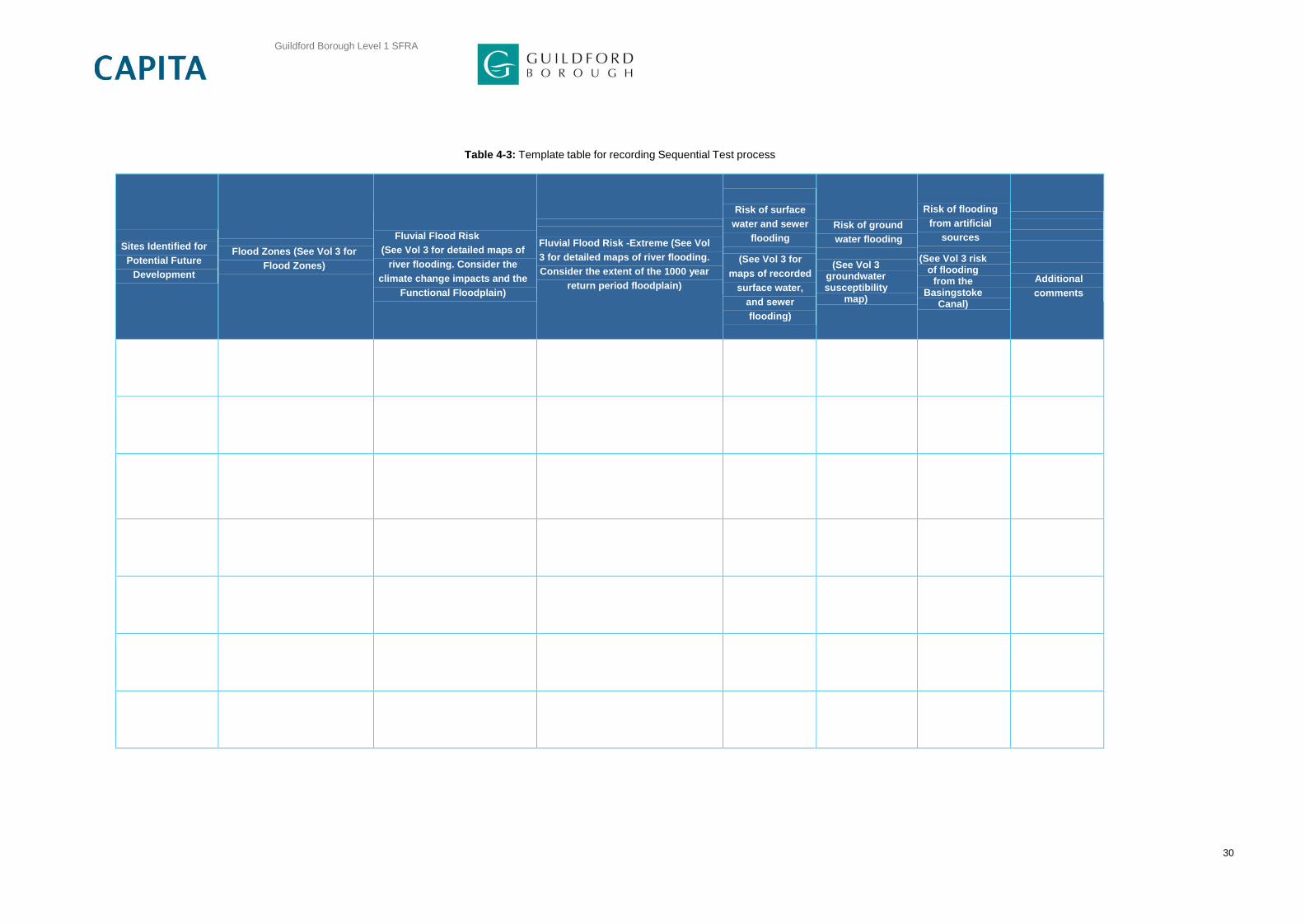
Table 4-3: Template table for recording Sequential Test process
Sites Identified for
Potential Future
Development
Flood Zones (See Vol 3 for
Flood Zones)
Fluvial Flood Risk
(See Vol 3 for detailed maps of
river flooding. Consider the
climate change impacts and the
Functional Floodplain)
Fluvial Flood Risk -Extreme (See Vol
3 for detailed maps of river flooding.
Consider the extent of the 1000 year
return period floodplain)
Risk of surface
water and sewer
flooding
(See Vol 3 for
maps of recorded
surface water,
and sewer
flooding)
Risk of ground
water flooding
(See Vol 3
groundwater susceptibility
map)
Risk of flooding
from artificial
sources
(See Vol 3 risk of flooding
from the Basingstoke
Canal)
Additional
comments

Guildford Borough Level 1 SFRA
31
NPPF acknowledges that some areas could also be at risk of flooding from flood sources other than
fluvial and tidal systems. Consequently all sources of flooding must be considered when looking to locate
development. Other sources of flooding requiring consideration when situating new development
allocations in Guildford Borough include:
Surface Water Flooding;
Groundwater;
Sewers; and
Artificial Sources.
4.2 How should the SFRA be used to apply the Sequential Test?
GBC should use the information presented in this Level 1 SFRA to undertake the Sequential Test. The
Sequential Test should be accurately documented to ensure that the decision processes followed for the
locating of a development are consistent and transparent.
It is recognised that flood risk information must be considered alongside other spatial planning issues.
Allocations are thus “Tested” on the basis of their flood risk attributes and the outcome used to inform
decisions that include other spatial planning issues such as transport, housing, economic growth, natural
resources, regeneration, biodiversity, the historic environment and management of other hazards.
All ‘reasonably available18
’ sites will need to be sequentially tested, including sites suggested through the
‘Call for Sites’ process, current records and sites in council ownership. GBC should then promote sites
accordingly, based on those at least risk of flooding and appropriate land uses. When applying the Test it
will be important for GBC to demonstrate:
That a transparent process has been formulated and followed;
That this process has sought to steer new development to areas with the lowest probability of flooding (according to Table 1 PPG); and
That full consideration has been given to reasonably available alternatives on land with a lower probability of flooding.
Table 4-3 provides a template table for GBC to consider when undertaking the Sequential Test. This
table can be used to record the information used in the decision making process for each allocated
area/site following the methodology outlined in the flow chart. The Flood Risk Matrix illustrates how the
Sequential Test should be undertaken. The development must be appropriate for the Flood Zone in order
to proceed to the Sequential or the Exception Test.
Additional guidance to assist GBC to strategically undertake the Sequential Test is detailed in Section
4.3.
18 (A site is only considered to be reasonably available if it is both ‘deliverable’ and ‘developable’ as
defined by the NPPF: • The site is within the agreed area of search.
• The site is of comparable size and can accommodate the requirements of the proposed development.
• The site is either: o Owned by the applicant; o For sale at a fair market value; or o Is publicly owned land that has been formally declared to be surplus and is available for purchase.
• The site is not safeguarded in the Local Plan for another use. Sites are not considered to be reasonably available if they fail to meet any of the above requirements or already have planning permission for a development that is likely to be implemented.)

Guildford Borough Level 1 SFRA
32
The flood risk information required to address the four stages in the application of the Sequential Test noted in the table below is provided in the relevant sections of Volume 2, and the flood maps in Volume 3 of this SFRA. Specific guidance for GBC on the use of these flood maps in the application of the Sequential Test is provided below in Table 4-4.
Table 4-4: Guidance for GBC on the use of this SFRA in the application of the Sequential Test
Stage in Sequential Test Guidance Associated Map Series in
Guildford Borough SFRA (Volume 3)
1. Can development be allocated
in Zone 1?
GBC should use Flood Zone
maps to identify areas within
Zone 1 and consider whether
proposed developments can be
allocated in Zone 1. Within Zone
1, areas at risk from other
sources of flooding should be
avoided where possible
Flood Zone Maps (Appendix C
Vol 3)
Also refer to Appendices D, E, F,
G for othersources of flooding
2. Where are the available sites
in Zone 2? Can development be
allocated within them?
GBC should use the Detailed
Maps of River Flooding to
identify areas within Zone 2 and
consider the lowest risk sites
first.
Detailed Maps of River
Flooding – (Appendix C, Vol 3)
3. Where are the lowest risk
available sites in Zone 3? Can
development be allocated within
them?
GBC should use the detailed
maps and indicative flood depth
maps within this SFRA to
understand the distribution of risk
within Flood Zone 3.
Detailed Maps of River
Flooding (Appendix C, Vol 3)
Flood Depth Maps (Appendix
C, Vol 3)
4. Is development appropriate
and permissible in remaining
areas?
In considering the
appropriateness of development
in remaining areas, GBC should
consider the vulnerability of the
proposed development and
Tables 2 and 3 of PPG Flood
Risk and Coastal Change.
Flood Depth Maps (Appendix
C, Vol 3)
Other Sources of Flooding
Maps (Appendices D, E, F, G,
Vol 3)
The protocols adopted for the Sequential Test should ideally be agreed with the EA. It is important that
the decision maker engages key stakeholders early in the decision making process. It is also important to
consider uncertainty of information when making land use planning decisions. For example is the
modelling data available detailed or broad scale and is it the most up to date (refer to Section 7.6 which
discusses when data should be reviewed).
4.3 Additional Guidance
The sequence of steps presented below in tandem with Figure 4.1 is designed to provide GBC and
developers with additional guidance on how to apply the Sequential Test strategically. The steps are
designed to ensure land allocations are allocated in line with the principles of the Sequential Test or,
failing this, that the requirement for application of the Exception Test is clearly identified.
1. Strategic developments that need to be accommodated in Guildford borough within the lifetime of its Local Plan should be assigned a vulnerability classification in accordance with Table 2 “Flood Risk Vulnerability Classification” in PPG.

Guildford Borough Level 1 SFRA
33
2. The Flood Zone classification of all development sites identified by GBC should consider the effects of climate change on flood zone definition for the design life of any development that the site may be suitable for.
3. Developers should use their experience within their locality to assess how long they anticipate the development being present for; a 60 year design life for non residential development plans should be used as a guide. Developers would be expected to justify why they have adopted a given lifetime for the development when preparing a site specific flood risk assessment. Residential development should be considered for a minimum of 100 year design life unless there is specific justification for considering a shorter period.
4. In the first instance any ‘highly vulnerable’ developments the LPA is seeking to accommodate should be located on potential development sites within Flood Zone 1. If the ‘highly vulnerable developments’ cannot be located in Flood Zone 1, because the identified sites are unsuitable or there are insufficient sites in Flood Zone 1 then sites in Flood Zone 2 can be considered, once having passed the Exception Test. If sites in Flood Zones 1 and 2 are inadequate, then to accommodate the development the LPA may have to identify additional sites in Flood Zones 1 or 2 or seek opportunities to locate the development outside their administrative area.
5. Once all ‘highly vulnerable’ developments have been allocated to a development site, the LPA can consider those development types defined as ‘more vulnerable’. In the first instance ‘more vulnerable’ development should be located in any unallocated sites in Flood Zone 1. Where these sites are unsuitable or there are insufficient sites, sites in Flood Zone 2 can be considered. If there are insufficient sites in Flood Zone 1 or 2 to accommodate the ‘more vulnerable’ development types, sites in Flood Zone 3a can be considered. However, any ‘more vulnerable’ developments in Flood Zone 3a will require application of the Exception Test (described in Section 5).
6. Once all ‘more vulnerable’ developments have been allocated to a development site, the LPA can consider those development types defined as ‘less vulnerable’. In the first instance ‘less vulnerable’ development should be located in any remaining unallocated sites in Flood Zone 1, 2 or 3a (in that order). Less vulnerable development types are not appropriate in Flood Zone 3b – Functional Floodplain.
7. ‘Essential infrastructure’ developments should also be preferentially located in the lowest flood risk zone, however this type of development can be located in Flood Zones 3a and 3b, where necessary, through application of the Exception Test.
8. Finally, it is recommended that water compatible development is allocated last. Water compatible developments typically have the least flood risk constraints and therefore it is considered appropriate to consider them last when allocating development sites.

Guildford Borough Level 1 SFRA
34
5. Guidance on Applying the NPPF Exception Test
5.1 What is the Exception Test?
As shown in Volume 3, some areas of Guildford borough are within Flood Zones 2 and 3 and are
predicted to have a medium or high risk of flooding. Following the application of the Sequential Test it
may not be possible for GBC to steer all new development towards flood zone 1, particularly when
regeneration objectives are taken into account. However, as required by the NPPF and NPPG GBC must
demonstrate that there are no other reasonable available alternative sites located in areas at less risk of
flooding.
If, following satisfactory application of the Sequential Test, it is not possible to allocate all development in
Flood Zone 1; the Exception Test may need to be applied to allocate sites in Flood Zones 2 and 3, as set
out in PPG. Following the application of the flood risk sequential test, should development sites need to
be considered in flood zones 2 and 3, subject to NPPF/NPPG criteria, an exception test may need to be
carried out and passed.
5.2 What is required to pass the Exception Test?
Figure 5.1 in Section 5 highlights the stages in the Sequential Test at which the Exception Test may need
to be applied. The PPG provides additional guidance on the application of the Exception Test.
If, following application of the Sequential Test, it is not possible, consistent with wider sustainability
objectives, for the development to be located in zones with a lower probability of flooding; the Exception
Test can be applied if appropriate. For the Exception Test to be passed:
it must be demonstrated that the development provides wider sustainability benefits to the community that outweigh flood risk, informed by a Strategic Flood Risk Assessment where one has been prepared; and
a site-specific flood risk assessment must demonstrate that the development will be safe for its lifetime taking account of the vulnerability of its users, without increasing flood risk elsewhere, and, where possible, will reduce flood risk overall.
The first criteria should be provided, for instance, through the sustainability appraisal. If a potential site
allocation fails to score positively against the aims and objectives of the sustainability appraisal, or is not
otherwise capable of demonstrating sustainability benefits, GBC should consider whether the use of
planning conditions and/or planning obligations could make it do so. Where this is not possible the
Exception Test has not been satisfied and the allocation should not be made.
The second part of the Exception Test relates to the “safety” of the development. The Planning Practice
Guide provides detail on ‘What is safe?’ When considering safety, specific local circumstances need to
be taken into account, including:
The characteristics of a possible flood event, e.g. the type and source of flooding and frequency, depth, velocity and speed of onset;
The safety of people within a building if it floods and also the safety of people around a building and in adjacent areas, including people who are less mobile or who have a physical impairment. This includes the ability of residents and users to safely access and exit a building during a design flood and to evacuate before an extreme flood;
The structural safety of buildings, and;
The impact of a flood on the essential services provided to a development.

Guildford Borough Level 1 SFRA
35
Figure 5.1 presents the process that should be followed by GBC in its application of the Exception Test under the PPG
Figure 5-1: An Application of the Exception Test for Local Plan preparation (PPG Flood Risk and Coastal
Change)
Information in Table 5.1 of this SFRA can be used to assess the safety of particular locations since it
gives greater detail on the actual risks, residual risks and the associated magnitude of the flood hazard.
As well as the safety of people while occupying a site consideration should be given to the safe access
and egress arrangements that can be implemented so that during flood events the appropriate level of
safety can be maintained.
Table 5-1: Guidance for GBC on the use of this SFRA in the application of the Exception Test
Exception Test safe development
Source of flood risk Guidance Associated Map Series in GY
SFRA
(Volume 3)
1. River flooding
The risk of fluvial flooding in much of
Guildford borough area is low.
The primary risk is in the river valleys of the
Wey (including the Tillingbourne and
Cranleigh Waters tributaries) and the
Blackwater.
Detailed Maps of River Flooding
(Volume 3, Figure 5B-X)
Show present day and future
flood outlines including the
impact of climate change

Guildford Borough Level 1 SFRA
36
Exception Test safe development
Source of flood risk Guidance Associated Map Series in GY
SFRA
(Volume 3)
2. Other sources of
flooding
This SFRA has also considered the risk of
flooding from surface water, sewers,
artificial sources and groundwater. There
are records of observed surface water and
groundwater flooding incidents within the
town.
Other Sources of Flooding –
Appendices D, E, F, G, Vol 3.
It is important that GBC retains a record of all assumptions and decisions made with regard to both the
Sequential and Exception Tests, in order to demonstrate the process has been performed. Once the
Tests are completed, and GBC is satisfied with the outcome, it is then possible to continue with the Local
Plan process.
Flood events, more than many other emergencies, can affect a wide number of homes and the time to
recover from a flood emergency can be prolonged. Accordingly it should be remembered that the level of
“safety” will vary depending on the vulnerability of the community affected. More vulnerable residents will
potentially be more severely affected by the consequences of flooding and levels of safety should be
commensurate with the risk.

Guildford Borough Level 1 SFRA
37
6. Guidance on How to Use the SFRA in Development Control
6.1 Guide to Volume 3 – Contents relevant to Development Control
Appendix A – Catchment overview
Appendix B – Flood Defences
Appendix C – Flood Zone 3b and Flood Risk from Rivers
Appendix D – Flood Risk from Surface water
Appendix E – Flood Risk from Groundwater
Appendix F – Flood Risk from Sewers
Appendix G – Flood Risk from Artificial Sources
6.2 Guidance for site-specific flood risk assessments
Although this SFRA has been undertaken for Guildford borough, it does not negate the need for site specific Flood Risk Assessments (FRA) to be undertaken at the planning application stage. Instead, this SFRA provides advice on the scope of the additional information required within FRA.
6.3 A Guide for Developers
The EA Guide for Developers (May 2013) provides a tool for developers to refer to during each
development stage. The guide gives advice on how a development can be better for people and the
environment.
At the Pre-Planning Application stage, the EA encourages developers to make enquiries on the EA
website that allows for a considered response. This stage of enquiries allows issues to be addressed
such as; a lack of information in the application, if there is any more information available to help the
application, and whether the application is likely to be refused. Pre-Planning Application Enquiries save
the developer time and money, and make sure the development is better for the environment
(Developers Guide, May 2013). Any bespoke pre-application advice from the EA will be chargeable.
The EA Pre-application enquiry form can be found at:
https://www.gov.uk/government/publications/pre-planning-application-enquiry-form-preliminary-opinion
In addition to NPPF, the Guide for Developers provides advice on “Managing the risk of flooding” by
ensuring the site land use and layout is appropriate to risk of flooding. This section of the guide also
details reiterates the government regulations set out by NPPF by stating the need for developers to
“avoid causing flooding elsewhere”.
The Guide for Developers details the permissions needed for Flood Risk Management. The Water
Resources Act 1991 and associated byelaws require the application for formal consent for works in, over,
under or adjacent to main rivers. This is to ensure that these activities don’t cause flooding or make an
existing flooding problem worse, and don’t damage the local environment, fisheries, wildlife, and flood
defences. Main rivers are watercourses designated by Defra and are usually larger rivers or streams.
The EA Guide for Developers is available at:

Guildford Borough Level 1 SFRA
38
https://www.gov.uk/government/uploads/system/uploads/attachment_data/file/289894/LIT_2745_c8ed3d.
The Development Management Procedure Order 2015 (DMPO) and Environment Agency’s Flood Risk
Standing Advice (FRSA) has been revised (April 2015). Comprehensive guidance and FRSA for
developers19
can be found online, and provides an excellent platform for developers. The FRSA
provides substantive responses to councils on lower risk planning applications in regards to flood risk
issues only. Bespoke comments on other non flood related issues may also be provided.
The FRSA for planning authorities20
also provides substantive responses to flood risk issues.
19
https://www.gov.uk/flood-risk-assessment-for-planning-applications 20
https://www.gov.uk/flood-risk-assessment-local-planning-authorities

Guildford Borough Level 1 SFRA
39
7. SFRA Maintenance and Management
7.1 Introduction
This chapter provides an introduction to the maintenance and management procedures that are required to
ensure Guildford Borough SFRA remains up-to-date and continues to make use of the best available
information. Implementing a maintenance and management procedure for the SFRA will assist GBC to
regularly review the technical data available and to commission technical updates where necessary.
Throughout this chapter, several key actions are recommended in the implementation of a maintenance and
management structure for the SFRA. These actions are highlighted in blue bold text.
7.2 Data Collection
The objective of this Level 1 report is to collate and review the information available relating to flooding in the
study area and present this in a manner suitable for GBC to apply the Sequential Test.
This section describes the data collection process, presents the available data and discusses its benefits and
limitations. A comprehensive record of all the data collected through the production of the Level 1 SFRA is
presented in a document register in Appendix A.
The information presented in this Level 1 report should not be considered as an exhaustive list of all available
flood related data for the study area. The Level 1 SFRA report is a presentation of the data collected following
consultation with and input from the partnering local authorities (neighbouring district / borough Councils, SCC
and the EA) within the timeframe available.
The Level 1 SFRA assessment methodology is based on using available existing information and data where
suitable. As a result, there has been no new investigation undertaken for this Level 1 SFRA.
7.2.1 Stakeholders The information used in this SFRA has been sourced from a variety of stakeholders including
Guildford Borough Council;
Surrey County Council;
Environment Agency - The study area is within the EA West Thames, which is responsible for the River Wey,
Basingstoke Canal Authority;
National Trust;
Thames Water - Thames Water is responsible for the management of surface water and foul water in the study area; and
British Geological Survey – Geological data used to derive SUDS suitability maps and susceptibility to groundwater data set.
It is recommended that during future iterations of the SFRA, the above organisations are contacted
to ensure that the most up-to-date records are included in the SFRA.
All of the data was registered on receipt and reviewed to assess its contribution to the Level 1 SFRA. Details
of all data collected are presented in Appendix A.
7.3 Data Processing
The following data processing was undertaken during the development of the SFRA:
Historic records of flooding were assessed to determine source of flooding and GIS layers were compiled. Maps and figures were produced using map templates designed for the SFRA report.

Guildford Borough Level 1 SFRA
40
7.4 Data Ownership
The datasets obtained for use in the SFRA have come from a number of sources under licence agreement.
These datasets cannot be passed to external sources without permission from the owner and those requiring
the data should ensure that they possess the appropriate copyrights and access. GBC should be aware of
the Intellectual Property Rights (IPR) they possess so that they only issue data that is contractually
appropriate. Datasets produced during the SFRA are owned by GBC and can be passed to external
parties at their discretion. Other datasets are the property of the EA and should not be released by GBC.
It is recommended that information on all sources of flooding continues to be collected and that where
appropriate more resources are invested in determining the source and pathways of flooding. When
more detailed or updated hydraulic modelling becomes available from the EA or other sources this
information should be incorporated into the SFRA. More detailed information may also be collected for
FRAs carried out by developers and land owners at the local site scale. Information from site level
FRAs will be submitted to the councils and the EA as part of the development control process and this
information should be used to inform the SFRA in the future.
7.5 SFRA data management system
The data management strategy developed for the SFRA is designed to account for likelihood that external
parties will seek to make use of the information within the SFRA in preparing flood risk assessments and
assessing sites. The SFRA is also a “live” document, and as such it is necessary to ensure at regular intervals
in the future that the information within it remains valid.
The final deliverables of the SFRA are delivered in two forms:
Digital copies of the SFRA reports – the SFRA contents are divided into several volumes and chapters to allow easier update during future iterations.
Electronic datasets including:
Raw GIS data - SFRA flood outlines and additional GIS data layers used to produce the SFRA
maps and figures. Some of these were obtained under licence from the Environment Agency.
All data is provided in a format compatible with GBCs existing corporate GIS infrastructure.
Electronic document management system - PDF versions of all maps and reports produced
during the SFRA.
To ensure that the SFRA remains ‘live’ it is important to nominate a Management Group with
responsibility for monitoring, managing and maintaining the SFRA, as shown in Figure 7.1. It is
recommended that the monitoring of the SFRA is linked to the Borough’s Monitoring report.
By following this process of information dissemination and review, the management team can ensure a
consistent and up to date supply of strategic flood risk information to all levels of planning process.

Guildford Borough Level 1 SFRA
41
Figure 7-1: SFRA Data management System
7.6 Monitoring the SFRA
It is in the interest of GBC that the SFRA remains current and up-to-date. To help facilitate this, it would be
useful for GBC to liaise regularly with West Thames of the EA to discuss the need for an update and if
necessary organise an annual meeting to review the SFRA. Prior to this meeting it is recommended
that the following maintenance checks be undertaken:
Review the datasets used in the SFRA are still the most up to date.
Consider whether a formal review of the SFRA is necessary.

Guildford Borough Level 1 SFRA
42
Whilst all datasets should be checked for updates and key organisations contacted, Table 7.1 contains a
list of datasets that are likely to be updated regularly.
Table 7-1: Datasets that are known to be updated regularly
Dataset Owner Comment
Flood Zones Environment Agency Updated quarterly
Catchment Flood Management Plans
Environment Agency
Updated every five years
National Flood and Coastal Defence Database (NFCDD)
Environment Agency
Ongoing updates
Historic flood incidents
Environment Agency, Water companies,
Surrey Fire and
Rescue services,
Highways authority,
Surrey.
Unknown
7.7 Incorporating new datasets
The following tasks should be undertaken when including new datasets in Guildford Borough
SFRA:
Identify new dataset.
Save new dataset/information.
Record new information in log so that next update can review this information.
7.8 Updating SFRA reports and figures
Volume 2 provides a record of all of the technical analyses used to develop Guildford Borough SFRA. In
recognition that the SFRA will be updated in the future, the report has been structured in chapters
according to the sources of flooding investigated. By structuring the report in this way, it is possible to
undertake further analyses on a particular source of flooding and only have to supersede the relevant
chapter, whilst keeping the remaining chapters unaffected.
In keeping with this principle, the following tasks should be undertaken when updating SFRA
reports and figures:
Undertake further analyses as required after SFRA review.

Guildford Borough Level 1 SFRA
43
Document all new technical analyses by rewriting and replacing relevant Volume 2 chapter/s.
Amend and replace relevant SFRA Maps in Volume 3.
Review and if required, amend Chapter 1 of Volume 1.
Reissue to departments within GBC and other stakeholders.

Guildford Borough Level 1 SFRA
44
8. Future Flood Risk Management Practices
Current flood risk management practises within the study area have been described in Section 3. This section describes the practises that are planned for the area or can be incorporated into new developments.
8.1 Strategic Flood Defences and Maintenance
Flood defences are typically designed and constructed to protect people and property from a given magnitude of flood. This is referred to as the design standard and may vary depending on the age of the structure, the value attributed to property and safety of people it is designed to serve and the scale of works necessary to construct the defence. Within Guildford borough there are no formal defences, but there are isolated flood relief facilities including flood relief channels and culverts. The flood relief schemes include the River Wey Improvement Scheme and the Broadmead and the Newark channels. GBC is also undertaking a project to install property level protection in approximately 35 properties in William Road, Mary Road, Leas Road and Walnut Tree Close in Guildford Town Centre. These are the locations which suffered from flooding in winter 2013.
There are a number of small watercourses across the study area. It is important that a maintenance regime is in place to ensure that there is regular cleaning and debris removal to prevent blockages from occurring. Where blockages do occur, flooding can occur quickly and although the disruption caused may be localised, flood depths and hazards can be significant. Across the study area, the responsibility for these watercourses lies with different organisations; but primarily with the Riparian owner (the person owning the banks). Thames Water, GBC and the EA have powers and sometimes duties to maintain watercourses.
It is important for GBC where possible to establish good relationships with the other maintaining bodies for these watercourses and then an open forum of discussion can exist, which in turn would lead to the benefit of reducing flood risk across Guildford borough. Mapping of, and improved communication between the bodies responsible for surface water drainage infrastructure is a key recommendation of Sir Michael Pitt’s review (2007).
8.1.1 Flood Warning
Ensuring people in areas of flood risk are aware of potential flooding is key to ensuring they are prepared,
facilitating the protection of property and evacuation where necessary (refer to Chapter 12 for additional
information).
Flood Warning is an essential component of the strategy to reduce flood risk. The EA seeks to provide a
flood warning service in all areas at risk of flooding. It consists of three flood warning codes – Flood Alert,
Flood Warning and Severe Flood Warning that indicate the level of danger. The flood warnings are
disseminated through a variety of mediums that include TV, radio, an automated voice messaging service
direct to a phone/fax/pager, the Internet and/or loudhailer. There is also an emergency Floodline number
(0345 988 1188) and a quick dial number for individual rivers.
Guildford Borough has been included as part of the Upper Wey Flood Alert area from July 2014. Up until
then, Guildford Borough had been covered by the Lower Wey flood alert area. This change will mean that
Flood Alerts covering Guildford Borough will be issued much earlier than they have been up until now
which will give the residents greater time to prepare for potential flooding. Guildford Borough will continue
to be covered by its own Flood Warning area which is issued when flooding is expected. The flood
Warning area of the River Wey is situated in a larger geographical area, where the EA provide a general
Flood Alert early notification to possible flooding. However, the flood warning system only operates for
fluvial flooding taking into consideration that a significant number of properties within urban areas of the
study area at risk from surface water flooding or experience flooding too quickly for current warning
systems to be effective, means that most flooding incidents are likely to occur without any warning.

Guildford Borough Level 1 SFRA
45
Sir Michael Pitt’s reviewi of the summer 2007 floods stresses the importance of developing a flood
warning system for surface water flooding. One of the report’s interim conclusions (IC3) was “the EA
further develops tools and techniques for predicting and modelling river flooding, especially to take
account of extreme multiple events; and takes forward work to develop similar tools and techniques to
model surface water flooding.”
8.1.2 Flood Alleviation Scheme Maintenance
The potential for flooding can be increased in areas where flood alleviation measures are not maintained
regularly and/or adequately. Breaches in raised flood defences, for example, are most likely to occur
where the defence has been degraded or not maintained to its design standard. Drainage infrastructure
in urban areas can also frequently become blocked with debris which, if not removed, can lead to
blockages in culverts and backing up of a watercourse resulting in flooding of property and infrastructure.
It is an essential aspect of flood risk management practise that all flood alleviation schemes and hydraulic
structures are regularly maintained to a specified design standard. It is the responsibility of the riparian
owner to maintain the watercourses or defences to a suitable standard. The Local Authority or EA has
permissive powers to act should the riparian owner not satisfy their maintenance requirements.
8.1.3 Flood Mitigation on site
Flood mitigation measures can also be incorporated within a development and are usually more
appropriate in areas of residual flood risk. The Pitt Review (Sir Michael Pitt, 2008) recognised the
importance of flood resilient and resistant techniques and came to an interim conclusion (IC11) that “no
new building should be allowed in a flood risk area that is not flood-resilient, and that Government should
work with organisations such as the Royal Institute of British Architects and the building industry to
encourage flood-resilient building and development design.”
The Code for Sustainable Homes (CLG, April 2010) also offers credits for developments that consider
flood risk. Preference is given to sites located in low flood risk zones, commensurate with policies
presented in NPPF. One credit is made available for developments in Flood Zones 2 or 3 that are
appropriately flood resilient and resistant.
Similar to the code for sustainable homes there is also a guide for Non-Domestic Buildings (CLG 2011).
One credit is made available for developments in Flood Zone 2 or 3 and 2 credits are available for
developments in Flood Zone 1.
When including flood avoidance (which should always be the first consideration through application of the
Sequential Test) flood risk mitigation measures that can be employed on individual sites can be split into
three categories:
Flood Avoidance
Flood Resistance
Flood Resilience
8.1.4 Flood Avoidance
This is defined as: -
‘Constructing a building and its surrounds (at site level) in such a way to avoid it being flooded (e.g. by
raising it above the flood level, re-sitting outside flood risk area etc.)’.

Guildford Borough Level 1 SFRA
46
These are used to restrict the pathway between the flooding source and the receptor. The preferential
option is to locate the building outside a flood risk area through rearranging the site layout if possible,
alternatives within this category could include a permanent or temporary defence such as raised kerbs to
contain and route flood water through a site or demountable barriers.
8.1.5 Flood Resistance
This is defined as:-
‘Constructing a building in such a way to prevent floodwater entering the building and damaging its
fabric’.
Floodwaters will enter buildings through the weakest points in the construction which maybe in the
brickwork, party walls of terraced or semi-detached buildings, expansion joints between walls where
different construction materials meet, vents, door thresholds, seepage from below ground through floors
and basements and/or sanitary appliances from backflow from surcharged drainage systems.
Flood resistance techniques can be employed on buildings. These can include raising finished floor levels
300mm above the design flood level including an allowance for climate change and the use of
appropriate materials that can withstand periodic flooding. They include the use of low permeability
materials in the construction of the building and are likely to only be effective for short duration flood
events and of low flooding depths (less than 0.3 m). They may be used in conjunction with flood
resilience techniques when the predicted flood level is between 0.3 - 0.6 m.
8.1.6 Flood Resilience/Repairable
This is defined as:-
‘Constructing a building in such a way that although floodwater may enter the building its impact is
reduced (i.e. no permanent damage is caused, structural integrity is maintained and drying and cleaning
is facilitated)’.
Flood resilience techniques are also employed on buildings within the floodplain. This type of approach
is often more appropriate when the predicted depth of flooding is greater than 0.3 m or flooding is
expected to last for a long time. In these cases the use of more durable materials that will not be easily
damaged by floodwaters as well as the use of construction materials that are more effective at draining
and drying are recommended.
There is currently no guidance with the UK Building Regulations for appropriate means of construction for
properties in flood risk areas. For more information on flood resistant construction refer to the
Communities and Local Government publication ‘Improving the Flood Performance of New Buildings:
Flood Resilient Construction’ (May, 2007).

Guildford Borough Level 1 SFRA
47
9. Drainage of Development Sites
Objective 6 of this Level 1 SFRA is to ‘advise GBC on the principles, objectives and applicability of
Sustainable Drainage Systems (SuDS) throughout the study area’. In keeping with the guidance of
NPPF, local authorities should encourage the application of Sustainable Drainage Systems (SuDS). This
section presents a summary of surface water policy and practices. Volume 1 should be referred to for
additional information on selection of the SuDS techniques available, and a review of the soils and
geology of the study area. Together, both sections should enable GBC to identify what type of SuDS
techniques could be employed in development schemes within the study area.
9.1 Background
Traditionally, built developments have utilised piped drainage systems to manage surface water and
convey surface water run-off away from developed areas as quickly as possible. Typically these systems
connect to the public sewer system for treatment and/or discharge to local watercourses. Whilst this
approach rapidly transfers surface water from developed areas, the alteration of natural drainage
processes can potentially impact on downstream areas by increasing flood risk and reducing water
quality. Receiving watercourses are therefore much more sensitive to rainfall intensity, volume and
catchment land uses after a catchment or areas of a catchment have been developed.
Flooding from sewers is typically less well publicised than flooding from rivers or the sea, in part due to
the often greater frequency with which sewer flooding can occur but predominately because it typically
affects geographically small areas for relatively short periods of time. However, the hazards and
nuisance of sewer flooding remain of particular concern in areas of growth.
Due to the difficulties and inconvenience associated with upgrading sewer systems it is uncommon for
sewer and drainage systems to keep pace with the rate of development/re-development. As development
progresses and/or urban areas expand, the drainage systems become inadequate for the volumes and
rates of surface water they receive, resulting in increased flood risk and/or pollution of watercourses.
Allied to this the implications of climate change on rainfall intensities, is predicted to lead to flashier
catchment/site responses and surcharging of piped systems.
In addition, as flood risk has increased in importance within planning policy, a disparity has emerged
between the design standard required of new conventional sewer systems and the return period against
which development should be safeguarded from flooding. New sewer systems are typically designed to
accommodate the 3.3% annual probability storm without flooding at the ground surface in accordance
with Sewers for Adoption21
whilst new developments are typically required to mitigate against the risks
from the 1% annual probability flood. This results in drainage inadequacies for the flood return period
developments need to consider. Whilst the risk of flooding from fluvial systems may be managed, an
inappropriately designed site drainage system could generate a new flood risk to development and
existing property.
A sustainable solution to these issues is to reduce the volume and/or rate of water entering the sewer
system and watercourses. The Government’s preferred method to achieve this is through the use of
SuDS.
9.2 What are SuDS?
SuDS are a varied collection of techniques designed to manage surface water in a sustainable manner.
SuDS achieve this by seeking to manage surface water from new developments as close to its source as
possible and by mimicking the surface water flow regime present on a site prior to development.
21
Sewers for Adoption , 7th Edition A Design and Construction Guide for Developer, September 2012

Guildford Borough Level 1 SFRA
48
Typically this approach involves a move away from conventional piped systems to softer engineering
solutions inspired by natural drainage processes.
For SuDS to be fully sustainable they should seek to contribute to each of the three goals of sustainability
(identified below), with the favoured system contributing equally to each goal. The three goals of
sustainable drainage systems are:
1. Reduce flood risk (to the site and neighbouring areas),
2. Reduce pollution, and,
3. Provide landscape and wildlife benefits.
In addition, SuDS should also be designed to ensure they remain effective for storm events up to and
including the 1% annual probability storm event including an increase in peak rainfall intensities to
account for the predicted effects of climate change.
9.3 SuDS Policies
Following changes within NPPF on the 6th April 2015, all Major Development planning applications will,
require the inclusion of SuDS designs. Full planning applications are required to be accompanied by a
detailed SuDS drainage design including simulation modelling of the proposed system. The SuDS pro-
forma must be completed and signed by a competent drainage engineer and submitted as part of the
planning application. The proposed drainage system shall be designed in accordance with the Non-
Statutory Technical Standards for Sustainable Drainage Systems and any forthcoming Sustainable
Drainage Systems Guidance from GBC.
In accordance with PPG paragraph 80, all planning applications must follow the hierarchy for
discharge destinations. Where it is not possible to achieve the first hierarchy, discharge through the
ground, applicants must demonstrate in sequence why the subsequent discharge destinations were
selected.
Where the intention is to dispose to soakaway, these should be shown to work through an appropriate
assessment carried out under Building Research Establishment (BRE) Digest 365. All designs shall be
based on actual infiltration figures obtained through percolation tests, carried out in accordance to BRE
Digest 365.
In accordance with CIRIA Report 156, Infiltration Drainage and SuDS Manual (C697 or latest amended
version C753), an adequate factor of safety must be applied to the observed infiltration value. The
minimum factor of safety acceptable is 2 and that must be increased to reflect the consequences of
failure of the system, the topography of the site and the likelihood of flooding.
Infiltration units must stand the test of half-emptying the provided storage within 24hrs for up to the 1 in
10 year annual probability storm (for all rainfall durations). The proposed infiltration devices shall not
intercept the water table and shall have at least 1m of unsaturated ground between the base of the
infiltration device and the water table. Therefore infiltration SuDS may not be suitable for use where
there is a shallow water table and insufficient unsaturated ground for soakage and or contamination.
There should be no infiltration of water into contaminated land.
If infiltration is not viable, subject to evidence being provided to support the choice of discharge
destination, proposals to dispose of surface water in to a watercourse, surface water sewer, highway
drain or another drainage system, should be accompanied by evidence of the system having spare
capacity downstream.
All development should aim to achieve pre-development greenfield run-off rates. If this is not
proposed, evidence must be submitted demonstrating why it has not been possible to achieve the
greenfield run-off rate and why it is only possible to achieve the proposed discharge rate.

Guildford Borough Level 1 SFRA
49
Sustainable drainage systems should be designed to ensure that the maintenance and operation
requirements are economically proportionate. GBC will need to decide on the strategy of adopting SuDS.
GBC, as the LPA, is expected to
Consult with SCC as the LLFA on the management of surface water.
Satisfy themselves that the proposed minimum standards of operation are appropriate.
Ensure through the use of planning conditions or planning obligations that there are clear arrangements in place for ongoing maintenance over the lifetime of the development.
9.3.1 Building Regulations 2008 H3 Rainwater Drainage
The Building Regulations 2008 (Approved UK Building Regulations 2008) enable the principles of the
NPPF to be enforced during construction by stipulating that:
1. Adequate provision shall be made for rainwater to be carried from the roof of the building;
2. Paved areas around the building shall be so constructed as to be adequately drained;
3. Rainwater from a system provided pursuant to sub-paragraphs (1) or (2) shall discharge to one of the following, listed in order of priority:
an adequate soakaway or some other adequate infiltration system; or, where that is not reasonably practicable,
a watercourse; or, where that is not reasonably practicable,
a sewer.
As the EA is the consenting authority for discharges to controlled waters (i.e. groundwater or
watercourses), SuDS will be favoured for the removal of pollutants and attenuation of discharge rates.
9.3.2 Environment Agency Policies
The Thames Catchment Flood Management Plan (Environment Agency, January 2007) also advocates
policies relating to SuDS, these are:
All sites greater than 1 hectare in size require the following:
o SuDS,
o Greenfield discharge rates,
o Attenuation of the 1 in 100 year storm event including allowance for climate change.
Allocated land should set-aside space for SuDS.
Volume 2, Chapter 5.7, provides further detailed information on the uses of SUDS in Guildford borough.

Guildford Borough Level 1 SFRA
50
10. Policy Considerations
Objective 4 of this Level 1 SFRA is ‘to advise GBC on suitable policies to address flood risk issues in a
consistent manner across its administrative area’. To meet this objective, national and local policies
have been reviewed (Section 3) along with the objectives and aspirations identified by the EA (outlined
in the Thames CFMP).
The SFRA will form part of the Local Plan evidence base, and should be used to inform the
preparation of planning policies in the emerging new Local Plan. It is not a policy document.
This section draws together information from the SFRA, to identify considerations for the formation of
planning policy. This list will be considered by policy makers along with other evidence base
documents, as needs and constraints are balanced to deliver sustainable development over the plan
period.

Guildford Borough Level 1 SFRA
51
Table 10-1: SFRA Policy Considerations
Policy Considerations
1 Apply the sequential test, and locate development in areas at least risk of flooding.
2 Seek to ensure development proposals do not increase flood risk, and where possible, reduce flood risk on site and elsewhere.
3 If, having passed the flood risk sequential test, development is proposed in areas at risk of flooding, then developers will be required to demonstrate through the exception test that suitable compensatory storage and mitigation can be provided, and that the development will result in an overall reduction of flood risk on site and, where possible elsewhere.
4 Consider the benefits of preparing planning guidance for development proposals in Guildford Town Centre in areas of medium to high flood risk, to encourage design that is resistant and resilient to flooding.
5 Consider the betterment opportunities from potential new park areas in Guildford Town Centre (with regards to the Guildford Town Centre Masterplan).
6 Consider ways to achieve betterment when development is proposed that could affect the River Wey floodplain.
7 Consider seeking detailed flood information when major development is proposed in areas at risk of flooding but where there is currently insufficient information on flood risk available
8 Consider seeking an assessment of groundwater flood risk for development proposals within areas potentially at risk of grounding water flooding. This could be part of a FRA, or a separate document.
9 Consider requirements and restrictions in relation to development impacted by or in proximity to the Basingstoke Canal and reservoirs.
10 Consider potential risk from embankment or structure failure from development in proximity to the River Wey navigation and the use of flood management measures.
11 Consider requirements in relation to surface water flood risk, particularly in relation to identified areas in the Guildford SWMP and Ash Surface Water Study.

Guildford Borough Level 1 SFRA
52
11. Site Specific Flood Risk Assessment Guidance
Objective 5 of this Level 1 SFRA is to ‘advise GBC on the requirements of site specific flood risk
assessments based on local conditions and policy considerations’.
Flood risk is a fundamental consideration for any development project regardless of scale or type.
Understanding the flood risk to and arising from a development is essential to managing the risk to
people and property reducing the risk of injury, property damage or even death. Climate change is of
particular concern to flood risk, with current predictions suggesting the UK will experience milder wetter
winters and on average hotter drier summers, whilst sea levels will continue to rise. This will lead to an
increase in rainfall and therefore flood events in winter months and increase the risk of thunderstorms in
the summer months, as well as increasing the unpredictability of our weather.
Evidence collected through this Level 1 SFRA demonstrates flooding in the study area is not limited to
just rivers (although it may be exacerbated by fluvial flooding). In fact flooding is proven to arise from a
number of sources, each presenting their own type of risk and requiring management. In addition some
areas currently not at risk of flooding may be at risk in the future as the effects of climate change take
hold.
A failure to adequately consider flood risk in development proposals can have significant implications for
the planning and development processes and longer term on the residents of new or existing
developments. Issues that may arise through inappropriate consideration of flood risk include:
Failure to consider wider plans prepared by the EA or other operating authorities may result in an objection to a proposed scheme.
Failure to identify flood risk issues early in a development project could result in failure of a development proposal, requiring redesign of the site to mitigate flood risk.
Failure to adequately assess all flood risk sources and construct a development that is safe over its lifetime could increase the number of people at risk from flooding and/or increase the risk to existing populations.
If an adverse effect can be demonstrated (i.e. flooding did not occur prior to development) by neighbouring properties or residents.
Properties may be uninsurable and therefore effectively unable to be sold if flood risk management is not adequately provided for the lifetime of the development.
However, development can work with flood risk if it is accurately understood and managed. Using a
sound understanding of flood risk to locate, and design developments enables flood risks to be managed
through positive planning. This positive planning needs to consider the risks to a development from local
flood sources but also the consequences a development may have on increasing flood risk. Early
identification of flood risk constraints can ensure developments maximise development potential whilst
achieving the principles of sustainability.
This Level 1 SFRA presents sufficient information to assist GBC to apply the Sequential Test and identify
where the Exception Test may be required. However, the scale of assessment undertaken for a Level 1
SFRA is typically inadequate to accurately assess the risks faced by a particular discrete development at
a given location with the study area. This Level 1 SFRA has attempted to identify all sources of flood risk
at the catchment and borough scale using the best available information. However, more local and site
specific sources of flooding may become apparent during a Level 2 SFRA or during the course of a site
specific FRA.

Guildford Borough Level 1 SFRA
53
In addition, the information presented in the Level 1 SFRA does not necessarily fully address all the flood
sources. For example, Flood Zones provided by the EA are not defined for all watercourses; typically
watercourses with a catchment area less than 3km2 are omitted from EA mapping unless there is a
history of flooding affecting a population. Consequently there will be some locations adjacent to
watercourses where on first inspection it is suggested there is no flood risk. This should be fully
investigated to ensure more people are not placed at risk through inappropriate development.
Therefore, as part of the planning applications which come forward in future for both allocated and non-
allocated sites, site specific FRAs will be required to assess the flood risk posed to individual discrete
proposed developments and to ensure that where necessary, and appropriate, suitable mitigation
measures are included in the development.
This section presents the recommendations for site specific FRAs, the circumstances under which they
should be prepared and their requirements for submission with planning applications to GBC.
The site specific Flood Risk Assessment guidance presented in the following sections has been
developed based on:
The recommendations presented in NPPF and its accompanying PPG;
The Environment Agency’s standing advice to LPAs;
A review of local policies and bye-laws throughout the study area; and
The information and findings gathered and developed during preparation of this Level 1 SFRA.
11.1 When are Flood Risk Assessments Required?
When informing developers of the requirements of a Flood Risk Assessment for a development site,
consideration should be given to the position of the development relative to flood sources, the
vulnerability of the proposed development and its scale.
In accordance with NPPF and the General Development Procedure Order (GDPO)22
FRAs should always
be provided with planning applications in the following situations:
The development site is located in Flood Zone 2 or 3;
The development site is equal or greater than 1 hectare in area in Flood Zone 1;
The development site is located in Flood Zone 1 but the Environment Agency, Internal Drainage Board and/or other bodies have identified critical drainage problems;
The development is located within 20m of any watercourse regardless of flood zone classification; or
The development involves any culverting operation or development which controls the flow of any river or stream.
The EA is a statutory consultee for planning applications that fall into the above situations with the
exception of minor developments in flood zones 2 and 3. Minor development23
in relation to flood risk
means:-
minor non-residential extensions: industrial/commercial/leisure etc. extensions with a footprint less than 250 square metres.
22
The Town and Country Planning (General Development Procedure) (Amendment) (No.2) (England) Order 2006
http://www.legislation.gov.uk/uksi/2006/2375/contents/made 23
Planning Practice Guidance Flood Risk and Coastal Change, 2014

Guildford Borough Level 1 SFRA
54
alterations: development that does not increase the size of buildings eg alterations to external appearance.
householder development: For example; sheds, garages, games rooms etc. within the curtilage of the existing dwelling, in addition to physical extensions to the existing dwelling itself. This definition excludes any proposed development that would create a separate dwelling within the curtilage of the existing dwelling eg. subdivision of houses into flats.
Minor developments are unlikely to raise significant flood risk issues unless:
they would have an adverse effect on a watercourse, floodplain or its flood defences;
they would impede access to flood defence and management facilities; or
where the cumulative impact of such developments would have a significant effect on local flood
storage capacity or flood flows.
For minor development in Flood Zone 2 and 3 it is the responsibility of the LPA to determine the suitability
of development against flood risk. In addition the LPA is also responsible for determining the suitability of
development against other forms of flooding (identified through this Level 1 SFRA). In summary the LPA
is responsible for determining the suitability of developments in the following situations:
Development sites less than 1 hectare in area;
Minor developments in Flood Zones 2 and 3; and
Developments at risk of flooding from flood sources other than fluvial or tidal (i.e. groundwater, surface water and infrastructure failures.
For developments in these situations the LPA must establish the requirements for FRAs and assess their
suitability as part of the planning application.
11.2 Flood Risk Assessments Requirements
In general for all planning applications where a FRA is required under the NPPF it will be necessary to
prepare a document to the satisfaction of the decision maker (GBC) who will seek the advice of the EA
and Surrey County Council as the LLFA when required.
Although not as well defined as in PPS 25 the NPPF states “there should be iteration between the
different levels of flood risk assessment”. Using the previous guidance in PPS 25 the following staged
approach comprises of:
The staged approach comprises:
Level 1 FRA - Screening Study
Level 2 FRA - Scoping Study
Level 3 FRA - Detailed Study
However it will not always be necessary to prepare each of the documents, in some cases where a site is
known to flood it may be appropriate to prepare a Level 2 or 3 assessment directly.
The following outlines the minimum requirements for FRA at each stage in the process. These include:
Considering the risk of flooding arising from the development in addition to the risk of flooding to the development;
Consider, where possible the opportunity to reduce flood risk;

Guildford Borough Level 1 SFRA
55
Identifying and quantifying the vulnerability of the development to flooding from different sources and identify potential flood risk reduction measures;
Assessments of the remaining ‘residual’ risk after risk reduction measures have been taken into account and demonstrate that this is acceptable for the particular development;
The vulnerability of those that could occupy and use the development, taking account of the Sequential and Exception Tests and the vulnerability classification, including arrangements for safe access;
Considering how the ability of water to soak into the ground may change with development, along with how the proposed layout of development may affect drainage systems.
Fully account for current climate change scenarios and their effect on flood zoning and risk.
Where a particular element of the FRA cannot be achieved to the satisfaction of the EA or LPA it will be
necessary to advance the next level of FRA.
11.2.1 Level 1- Screening Study A Level 1 Screening Study is intended to identify if a development site has any flood risk issues that
warrant further investigation. This should be based on existing information such as that presented in this
Level 1 SFRA. Therefore this type of study could be undertaken by a development control officer in
response to the developer query or by a developer where the Level 1 SFRA is available. Using the
information presented in the Level 1 SFRA and associated GIS layers a development control officer could
advise a developer of any flooding issues affecting the site. This information could then be used by the
developer as a basis to further their understanding of how the flood risks could potentially affect their
development.
11.2.2 Level 2 – Scoping Study A level 2 Scoping Study is predominately a qualitative assessment designed to further understanding of
how the flood sources affect the site and the options available for mitigation. The Level 2 FRA should be
based on existing information to further a developers understanding of the flood risk and how it affects
their development. This type of assessment should also be used to inform site master plans raising a
developer’s awareness of the flood management elements the proposed development may need to
consider.
11.2.3 Level 3- Detailed Study Where the quality and/or quantity of information for any of the flood sources affecting a site is insufficient
to enable a robust assessment of the flood risks, further investigation will be required. For example it is
considered inappropriate to base a flood risk assessment for a residential care home at risk of flooding
from fluvial sources on Flood Zone maps alone. In such cases the results of hydraulic modelling are
required to ensure details of flood flow velocity, onset of flooding and depth of flood water is fully
understood and that the proposed development incorporates appropriate mitigation measures.

Guildford Borough Level 1 SFRA
56
12. Emergency Planning
Objective 7 of this Level 1 SFRA is ‘to present sufficient information to inform GBC of the flood
considerations necessary in developing and progressing flood emergency planning’.
In Sir Michael Pitt’s Review of the 2007 floods he recognises the ‘dedicated and quick response’ of
emergency services which prevented the worsening of many situations. However, he also identified a
number of failings and opportunities to improve our preparedness for future flood events. In particular he
advises that with ‘stronger local leadership of flood risk management, clarification of roles, more effective
co-operation between responsible organisations, better protection of infrastructure and wider and deeper
public engagement’ the impact of flooding on communities could be significantly reduced.
For many of these opportunities identified by Sir Michael Pitt to be achieved, the role local authorities
have in planning and responding to flood events must be clearly defined. To assist local authorities in
understanding their role it is essential to have a technically sound emergency plan in place to provide
clear procedural instructions to the organisations, companies and individuals involved and affected.
The mobilisation and organisation of the emergency services and supporting agencies (for example
GBC) can be integral to the coordinated rescue, treatment and transport of potentially large numbers of
displaced residents or casualties. Similarly, during and after a flood event the role of the local authority
can include providing transport for the evacuees and safe rest centres in the event of homes being
flooded. Further health and welfare issues are inevitable as a result of serious flood events, which may
impact on the ability of people to return to their homes or places of business.
Whilst this SFRA is not designed to fulfil the role of providing an emergency plan it does contain useful
information for GBC and other key organisations to assist them in understanding their risks (direct and
indirect) and begin the process of developing an appropriate co-ordinated response.
12.1 Developing an Emergency Flood Plan
The existing GBC Emergency Plan (2013) sets out the procedures for the activation of the Borough
Emergency Management Team (BEMT) who will lead the Borough Council’s response to a major
incident. It is prepared for the guidance of Borough Council Officers, who may be required to provide
additional services to meet the demands of a major peacetime emergency in order to minimise the impact
of an event on the community, protect lives, the environment and ensure continuity of service provision.
Updates to the emergency plan were proposed after the Winter 2013 flooding.
Specific plans have been developed by the Council for severe weather and flooding incidents, the
activation of rest centres as well as business continuity. These are available from the District Emergency
Planning Liaison Officer (DEPLO).
12.2 Use of the Emergency Plan in the Planning System
With the appropriate management of flooding taking increasing importance in the planning system, more
developments will be required to ensure they appropriately manage their risks and do not exacerbate the
risks to surrounding property and residents as a consequence of development.
Whilst much of the impact of development should be mitigated through appropriate proactive planning
(through application of the Sequential Test), there will remain some developments that will take place in
areas at risk of flooding. In such circumstances, developments should be constructed in such a way as to
safeguard them and their residents from flooding; however the impact of the development on the ability of
emergency services to maintain current standards of service should also be considered.
Ensuring a robust emergency plan is in place will enable GBC to establish where a proposed
development will place an unreasonable pressure on emergency services and may increase risks to the

Guildford Borough Level 1 SFRA
57
existing population. Similarly it will enable developers to incorporate appropriate mitigation measures into
their developments to minimise the impact it will have on the existing emergency service provision.

Guildford Borough Level 1 SFRA
58
13. Other Possible Users of the SFRA
13.1.1 The information contained within the SFRA is primarily compiled for use in the Local Plan
process and in Development Control, however the information on flooding may also be useful to a much wider range of users. These potential users include (but are not limited to):
Transport and highways team including strategic transport planners – the SFRA can be
used to identify flood risk to essential infrastructure, both proposed and existing;
Education Building Development and Education and Children’s teams – the SFRA
should be used to ensure flood risk is considered in the allocation of land for new
schools and also used to inform emergency plans that make use of school buildings;
Police Constabulary – the SFRA can be used to inform future updates of the Flood
Plan. Information within this SFRA on the spatial distribution of flood risk throughout the
area should also be used by the Police (and other developers of critical infrastructure)
when locating new sites or developments.
13.1.2 In order to ensure these potential users are integrated into the SFRA process, it is recommended that this report is made available for their comment, review and future input as appropriate.

Guildford Borough Level 1 SFRA
59
14. Conclusions and Recommendations
14.1 Conclusions
Evidence collected through this Level 1 SFRA proves areas of Guildford borough are susceptible to
flooding from a variety of flood sources. Flood sources include:
Fluvial;
Surface Water ;
Drainage/Sewers; and,
Groundwater.
Generally existing development is at limited risk of fluvial flooding within the study area. However, there
are some key areas of development and infrastructure at risk of flooding. With the prospect of climate
change it is considered that these causes of flood risk will worsen unless management practices are
changed and/or mitigation measures are implemented.
14.2 The Next Stage
14.2.1 Strategic Planning Policy
Using the information presented in this Level 1 SFRA, GBC should apply the NPPF Sequential Test to
their strategic land allocations and future windfall sites, seeking to guide development to areas of lowest
flood risk wherever possible.
Where there are insufficient sites in areas of low flood risk to accommodate the required growth,
consideration can be given to development in higher risk flood zones, but GBC should give consideration
to the vulnerability of developments, seeking to match development vulnerability to acceptable levels of
flood risk.
In addition GBC should give consideration to the policy considerations within Section 10, as it develops
its Local Plan.
14.3 Recommendations
14.3.1 Requirement for a Level 2 SFRA
Where a Level 1 Assessment shows that land outside flood risk area cannot appropriately accommodate
all the necessary development, it may be necessary to increase the scope of Assessment to a Level 2
SFRA. This more detailed assessment would provide the information necessary for application of the
Exception Test where appropriate. The Level 2 SFRA should improve the quantity/quality of data
available in those areas requiring the Exception Test such that decisions regarding the safety and impact
of the proposed developments can be made on robust data.
Such situations will include any development allocations in areas of Flood Zone 3 and some locations in
Flood Zone 2 where the development vulnerability dictates.
14.3.2 Development Control

Guildford Borough Level 1 SFRA
60
Development Control Officers within GBC should familiarise themselves with the SFRA and ensure that site specific Flood Risk Assessments are provided where necessary and prepared against the recommendations of Table 6.1.
14.3.3 Emergency Planning
GBC should use the findings of this Level 1 SFRA to refine and inform emergency plans developed for
the area. This should include liaison with local emergency services to share and discuss the available
data and its implications for emergency planning. When developed, the emergency plans can then be
integrated with the planning system for those developments that cannot be located in lower risk flood
zones.
14.3.4 River Wey River Bank Strategy
GBC should produce a strategy to advise riparian owners and future property developers on their
obligations for the maintenance of riparian areas including a strategy for maintaining and where
necessary improving the standard of defence offered by flood defence structures along the River Wey
through Guildford urban area.
Such a strategy should be developed in liaison with the Environment Agency.
14.4 When should the SFRA be updated
NPPF and the EA intend for SFRAs to be living documents, updated as new data is available. New
sources of data become available all the time and as such GBC should liaise with the EA to determine a
suitable period for review and update of the SFRA that is acceptable to all parties. This may include
consideration of:
New climate change updates;
Modelling result updates;
Development of new flood alleviation measures;
New model data;
Issue of new guidance documentation; and/or
Development of all allocations; or
Developments through the EU Flooding Directive.

Guildford Borough Level 1 SFRA
61
15. References
National Planning Policy Framework. Communities and Local Government Publications,
London, (March 2012).
Planning Practice Guidance. Communities and Local Government Publications,
London.
Thames Catchment Flood Management Plan: Summary Report: Consultation
Environment Agency, Bristol, (December 2009).
Guildford Strategic Flood Risk Assessment, Capita Symonds, (January 2009).
Flood Risk Reduction Measures, Environment Agency, (November 2010).
Surrey County Council Preliminary Flood Risk Assessment (June 2011)
Guildford Surface Water Management Plan, Halcrow (November 2013)
Guildford Borough Council (Peter Brett Associates), Bedford Road Flood Risk
Assessment, January 2006
Environment Agency (West Thames), River Wey Flood Mapping Study, Main Report
Volume 1 (Atkins) February 2006.
Lower Wey Remodelling Flood Study Modelling Report, Mott MacDonald (December
2009)
River Blackwater Flood Study Final Flood Mapping Report, peter brett associates
(August 2007)
Environment Agency, Sustainable Drainage Systems (SUDS) – an introduction, May
2003
Flood Risk Assessment Guidance for New Development: Phase 2, FD2320/2
Woods Ballard, B., Kellagher, R., (2007a) Site Handbook for the Construction of SuDS
(C698), (CIRIA; London
Sir Michael Pitt (2008). Floods Review
(http://www.cabinetoffice.gov.uk/thepittreview.aspx).

Guildford Borough Level 1 SFRA
62
16. Glossary and Notation
Term Definition
Alluvium Sediments deposited by fluvial processes / flowing water
Annual Exceedance
Probability (AEP)
The probability of an event occurring within any one given year.
Attenuation In the context of this report - the storing of water to reduce peak
discharge of water
Aquifer
A source of groundwater comprising water-bearing rock, sand or gravel
capable of
yielding significant quantities of water.
Breach An opening – For example in the sea defences
Brownfield Previously developed land, usually of industrial land use within inner city
areas.
Catchment Flood
Management Plan
A high-level planning strategy through which the EA works with their key
decision makers within a river catchment to identify and agree policies to
secure the long-term sustainable management of flood risk.
Culvert/culverted A channel or pipe that carries water below the level of the ground.
Drift Geology Sediments deposited by the action of ice and glacial processes
EA Flood Zone 1 Low probability of flooding
EA Flood Zone 2
Medium probability of flooding. Probability of fluvial flooding is 0.1 – 1%.
Probability
of tidal flooding is 0.1 – 0.5 %
EA Flood Zone 3a
High probability of flooding. Probability of fluvial flooding is 1% (1 in 100
years) or greater. Probability of tidal flooding is 0.5%(1 in 200 years)
EA Flood Zone 3b Functional floodplain
Estuary A tidal basin , where a river meets the sea, characterised by wide inlets
Exception Test
The exception test should be applied following the application of the
Sequential
Test. Conditions need to be met before the exception test can be
applied.
Flood defence
Infrastructure used to protect an area against floods as floodwalls and
embankments; they are designed to a specific standard of protection
(design standard).
Floodplain Area adjacent to river, coast or estuary that is naturally susceptible to
flooding.
Flood Resilience Resistance strategies aimed at flood protection
Flood Risk
The level of flood risk is the product of the frequency or likelihood of the
flood events and their consequences (such as loss, damage, harm,
distress and disruption)
Flood Risk
Assessment
Considerations of the flood risks inherent in a project, leading to the
development actions to control, mitigate or accept them.
Flood storage A temporary area that stores excess runoff or river flow often ponds or
reservoirs.

Guildford Borough Level 1 SFRA
63
Flood Zone The extent of how far flood waters are expected to reach.
Fluvial Relating to the actions, processes and behaviour of a water course
(river or stream)
Fluvial flooding Flooding by a river or a watercourse.
Freeboard Height of flood defence crest level (or building level) above designed
water level
Functional
Floodplain
Land where water has to flow or be stored in times of flood.
Freeboard Height of the flood defence crest level (or building level) above designed
water level.
GIS Geographic Information System – A mapping system that uses
computers to store,
manipulate, analyse and display data
Greenfield Previously undeveloped land.
Groundwater
Water that is in the ground, this is usually referring to water in the
saturated zone below the water table.
Highly Vulnerable
Developments
Developments that are at highest risk of flooding.
Hydraulic Modelling
A computerised model of a watercourse and floodplain to simulate water
flows in rivers too estimate water levels and flood extents.
Hydrodynamic
Modelling
The behaviour of water in terms of its velocity, depth and hazard that it
presents.
Infiltration The penetration of water through the grounds surface.
Infrastructure
Physical structures that form the foundation for development.
Inundation Flooding.
LiDAR Light Detection And Ranging – uses airborne scanning laser to map the
terrain of the land.
Local Development
Framework (LDF)
The core of the updated planning system (introduced by the Planning
and
Compulsory Purchase Act 2004). The LDF comprises the Local
Development
Documents, including the development plan documents that expand on
policies and provide greater detail. The development plan includes a
core strategy, site allocations and a proposals map.
Local Planning
Authority
Body that is responsible for controlling planning and development
through the planning system.
Main River Watercourse defined on a ‘Main River Map’ designated by DEFRA. The
EA has permissive powers to carry out flood defence works,
maintenance and operational activities for Main Rivers only
Mitigation measure
An element of development design which may be used to manage flood
risk or avoid an increase in flood risk elsewhere.
Overland Flow
Flooding caused when intense rainfall exceeds the capacity of the
drainage systems or when, during prolonged periods of wet weather, the
soil is so saturated such that it cannot accept any more water.
Overtopping
Water carried over the top of a defence structure due to the wave height
exceeding the crest height of the defence.
Reach/ Upper reach A river or stream segment of specific length. The upper reach refers to
the upstream section of a river.
Residual Flood Risk The remaining flood risk after risk reduction measures have been taken
into account.
Return Period
The average time period between rainfall or flood events with the same
intensity and effect.

Guildford Borough Level 1 SFRA
64
Risk The probability or likelihood of an event occurring.
River Catchment The areas drained by a river
SAR
Synthetic Aperture Radar - a high resolution ground mapping technique,
which uses reflected radar pulses.
Sequential Test Aims to steer development to areas of lowest flood risk.
Sewer flooding Flooding caused by a blockage or overflowing in a sewer or urban
drainage system.
Solid Geology
Solid rock that underlies loose material and superficial deposits on the
earth’s
surface
Source Protection
Zone
Defined areas in which certain types of development are restricted to
ensure that groundwater sources remain free from contaminants.
Standard of
Protection
The flood event return period above which significant damage and
possible failure of the flood defences could occur.
Storm surge A high rise in sea level due to the winds of the storm and low
atmospheric pressure.
Sustainability To preserve /maintain a state or process for future generations.
Sustainable
drainage
system
Methods of management practices and control structures that are
designed to drain surface water in a more sustainable manner than
some conventional techniques.
Sustainable
development
Development that meets the needs of the present without compromising
the ability
of future generations meeting their own needs
Tidal Relating to the actions or processes caused by tides.
Topographic survey A survey of ground levels.
Tributary A body of water, flowing into a larger body of water, such as a smaller
stream joining a larger stream.
1 in 100 year event Event that on average will occur once every 100 years. Also expressed
as an event, which has a 1% probability of occurring in any one year.
1 in 100 year design
standard
Flood defence that is designed for an event, which has an annual
probability of 1%.
In events more severe than this the defence would be expected to fail or
to allow flooding.

Guildford Borough Level 1 SFRA
65
Appendix A Data Document Register

Guildford Borough Level 1 SFRA
Capita Property and Infrastructure Ltd
65 Gresham Street,
London
EC2V 7NQ
Tel +44 (0)20 7492 0200
www.capita.co.uk