guidelines on erosion control for development projects...
TRANSCRIPT
GUIDELINES ON EROSION CONTROL FO DEVELOPMENT PROJECTS IN THE COASTAL ZONE
- i -
DID GUIDELINES 1/97
GUIDELINES ON EROSION CONTROLFOR
DEVELOPMENT PROJECTSIN
THE COASTAL ZONE
DEPARTMENT OF IRRIGATION AND DRAINAGEM A L A Y S I A

GUIDELINES ON EROSION CONTROL FO DEVELOPMENT PROJECTS IN THE COASTAL ZONE
- ii -
CONTENTS Page
PREFACE……………………………………………………………………………………iii
1.0 BACKGROUND……………………….…....................................................................1
2.0 GUIDELINES ON EROSION CONTROL FOR DEVELOPMENTPROJECTS IN THE COASTAL ZONE …....................................................................3
2.1 INTRODUCTION .................................................................................................3
2.2 DATA REQUIREMMENT ...................................................................................3
2.3 TYPES OF COASTAL DEVELOPMENT ..........................................................5
2.3.1 SHORE FRONT DEVELOPMENT PROJECTS......................................5
2.3.2 BACK SHORE DEVELOPMENT PROJECTS........................................8
2.3.3 LAND RECLAMATION.........................................................................10
2.3.4 OFFSHORE SAND MINING AND RIVER MOUTH DREDGING......11
2.4 CONCLUSION....................................................................................................13
3.0 FIGURE 1: FLOW CHART FOR PROCESSING SHORE FRONT DEVELOPMENT …………...15
FIGURE 2: FLOW CHART FOR PROCESSING BACK SHORE DEVELOPMENT ………….…16
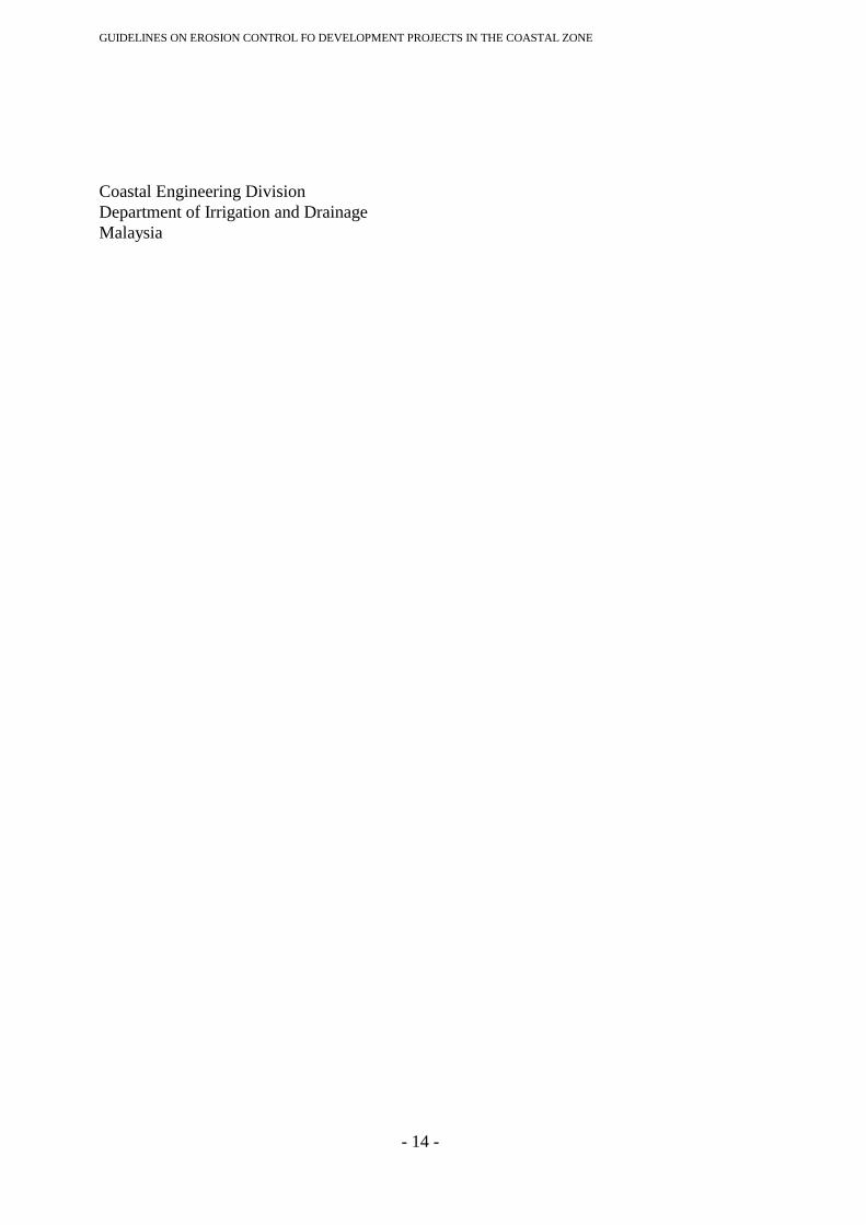
FIGURE 3: FLOW CHART FOR PROCESSING LAND RECLAMATION ………………….……17
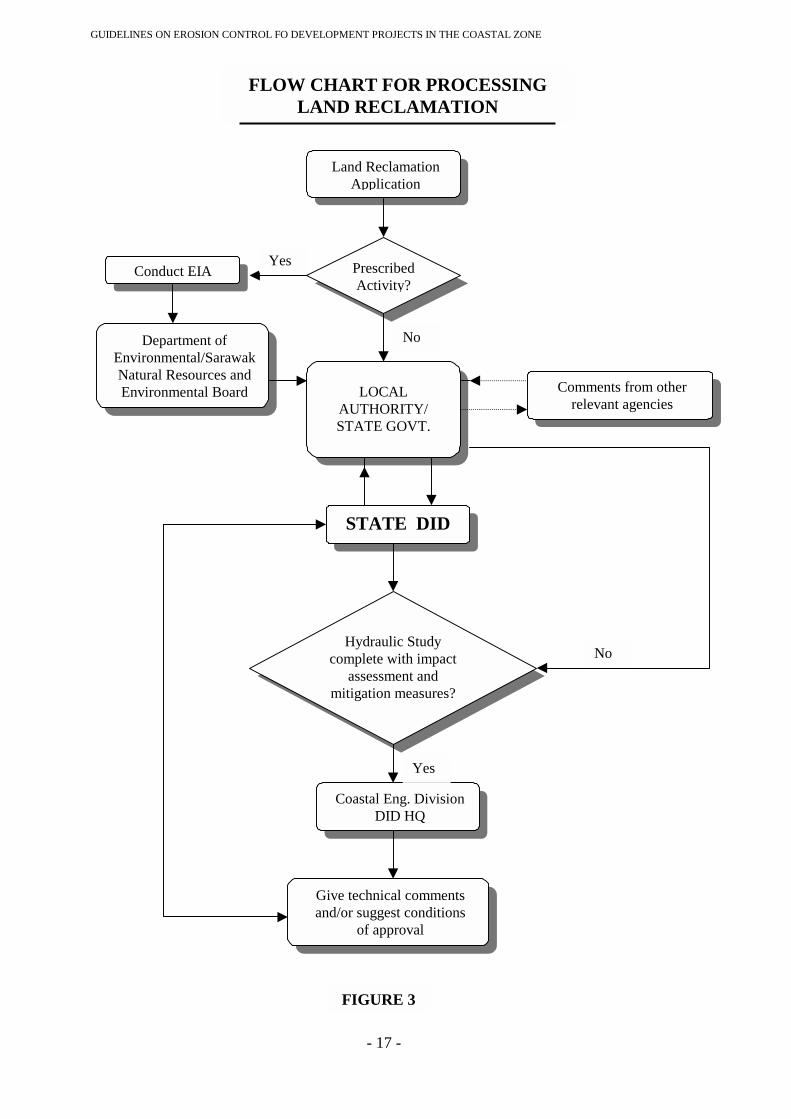
FIGURE 4: FLOW CHART FOR PROCESSING SAND MINING AT STATE LEVEL …………..18
FIGURE 5: FLOW CHART FOR PROCESSING SAND MININGAT FEDERAL LEVEL …….…19
4.0 APPENDIX I: GENERAL ADMINISTRATIVE CIRCULAR NO. 5 OF 1987 ….…………………..20
GUIDELINES ON EROSION CONTROL FO DEVELOPMENT PROJECTS IN THE COASTAL ZONE
- iii -
PREFACE
The "Guidelines on Erosion Control for Development Projects in the Coastal Zone" wasapproved by the Cabinet on 27 Jan.1997 and is aimed at ensuring the proper planning andsustainable development of the coastal zone. The guideline describes in detail the datarequirements and the scope of impact evaluation for the various types of development in thecoastal zone namely shorefront development, backshore development, land reclamation andoffshore sand mining and river mouth dredging. The guideline is also supplemented with flowcharts for the processing of development applications.
The contents of these guidelines are intended primarily for decision-makers, project proponentsas well as consultants involved in development projects in the coastal zone. This bookletcontains some background information as well as the full text of the approved guidelines.
GUIDELINES ON EROSION CONTROL FO DEVELOPMENT PROJECTS IN THE COASTAL ZONE
- 1 -
1.0 BACKGROUND
1.1 Since 1987, upon the completion of the National Coastal Erosion Study (NCES),the Government of Malaysia has been adopting a two-pronged strategy (short termand long term) for the control of coastal erosion. The short-term strategy isconstruction focused and reactive in nature and aimed at preventing the further lossof existing facilities, properties and valuable land from the result of coastal erosion.The long-term strategy on the other hand, is management focused and aimed toobviate the need for expensive protective works in the future by according dueconsideration to the consequences of coastal erosion in the planning andimplementation of projects in the coastal zone. This is achieved through institutingnon-structural and regulatory measures such as proper land use planning andcontrol of development projects in the coastal zone.
1.2 Among the regulatory measures instituted by the Government are the GeneralAdministrative Circular No. 5 of 1987 issued by the Prime Minister's Department,the Environmental Quality Act 1974, Environment Quality (Prescribed Activities)(Environmental Impact Assessment) Order 1987, and the Natural Resources andEnvironment Ordinance (Sarawak) 1949 (As Amended 1994). Circular No. 5 of1987 requires all proposed development projects in the coastal zone to be referredto the Coastal Engineering Division (CED) of the Department of Irrigation andDrainage (DID) for comments while the Environmental Impact Assessment (EIA)Order 1987 spells out a list of development activities which require mandatorysubmission of EIA reports for prior approval of the Department of Environment(DOE). CED provides assistance to DOE in the form of providing review andcomment on EIA submissions for projects, which affect the coastline,
1.3 Through these regulatory measures, CED has provided advice to approvingauthorities for development project applications in the coastal zone by pointing outpotential impact, in particular, from the consideration of risk of coastal erosion andoverall stability of the directly affected or adjacent shorelines. On average, CEDprocesses and provides comments on some 170 proposed development applicationsand 30 EIA reports on development projects in the coastal zone annually. TheGovernment of Malaysia is however, aware that the Administrative Circular No.5/1987 and the EIA Order 1987 are only instruments to promote effective coastalzone management but are inadequate by themselves to bring about integratedcoastal zone management and sustainable development.
1.4 As a result, the Economic Planning Unit (EPU) of Malaysia embarked on thepreparation of a National Coastal Resources Management Policy in early 1992 as afirst step towards a rational and integrated approach in coastal zone management inMalaysia. For that purpose, the EPU had set up an Inter-Agency Planning Group(IAPG) comprising of members from all the relevant agencies such as Ministry ofAgriculture, Ministry of Science, Technology and the Environment. Ministry ofLand and Cooperatives Development, Ministry of Housing and Local Government,Ministry of Transport, Ministry of Primary Industries, Department of Environment,Department of Agriculture, Department of Irrigation and Drainage, Department ofPublic Works, Department of Forestry, Department of Town and Country Planning,Department of Survey and Mapping. Department of Geological Survey, the

GUIDELINES ON EROSION CONTROL FO DEVELOPMENT PROJECTS IN THE COASTAL ZONE
- 2 -
Attorney General's Office, Implementation and Coordination Unit of the PrimeMinister's Department, and the Forestry Research Institute.
1.5 To assist the IAPG three Technical Working Groups (TWG) were established tostudy in detail the various related aspects and to prepare inputs for drawing up therequired final policy. TWG- I on Coastal Resources was to define the coastal zone,describe its resources and document the resource utilisation problems; TWG-2 onCoastal Planning Processes was to analyse the strengths and weaknesses of thecurrent planning system and to propose a multi-sectoral holistic approach to coastalzone planning which can be implemented nation-wide; while TWG-3 onLegislation and Institutional Aspects was to review the legislative and institutionalarrangements for coastal zone planning and management. All the technicalworking groups have completed their reports in mid 1993, while EPU is currentlyfinalising the policy document.
1.6 Nevertheless, the National Coastal Resources Management Policy aims to providethe framework to ensure that the development of coastal resources and land use inthe coastal zone will be properly planned and managed. This is to preserve andenhance the coastal environment and coastal resources for sustainable use anddevelopment for both present and future generations, as well as to identify andprotect the critical coastal ecosystem and unique areas in the coastal zone. It isexpected to include a specific management plan complete with guidelines asappendices for the following resources and activities:
(a) Coastal and Mangrove Forest(b) Fisheries and Aquaculture(c) Coastal and Offshore Sand Mining and Mineral Resources(d) Coastal Erosion and Sedimentation(e) Water Resources and Water Quality(f) Coastal Land Use(g) Islands, Coral Reefs and Associated Marine Ecosystems
1.7 In view of the increasing incidences of coastal erosion (the number of criticalerosion sites had increased from 45 sites measuring 140 km. at the end of theNCES to 74 sites measuring 232,7 km. currently) and increasing pace ofdevelopment in the coastal zone, the National Coastal Erosion Council in itsmeeting on 28 January 1995 requested EPU to form a committee to formulateguidelines for erosion control for development projects in the coastal zone at thesoonest possible. A working committee to formulate the guidelines was formallyestablished by EPU in June 1995 comprising of members from EPU,Implementation and Coordination Unit of the Prime Minister's Department,Ministry of Agriculture, Department of Environment, Department of Fisheries,Department of Town and Country Planning and Department of Irrigation ofDrainage which served as the secretariat.
1.8 The Guidelines were completed and presented by the Director General, Departmentof Irrigation and Drainage to the National Development Council (NDC) at itsmeeting on 17 June 1996. Following the endorsement and approval of theGuidelines at that meeting, DID was requested to submit the Guidelines for Cabinetapproval through the Ministry of Agriculture. The Cabinet subsequently approvedthe Guidelines for implementation at its regular meeting on 29 January 1997. The
GUIDELINES ON EROSION CONTROL FO DEVELOPMENT PROJECTS IN THE COASTAL ZONE
- 3 -
completed guidelines which aim at ensuring proper planning and implementation ofcoastal development projects to obviate the need for expensive coastal protectionworks in the future and to ensure sustainable development of the coastal zone.
2.0 GUIDELINES ON EROSION CONTROL FOR DEVELOPMENTPROJECTS IN THE COASTAL ZONE
2.1 INTRODUCTION
These guidelines are to be used for processing applications for development in thecoastal zone in accordance with the General Administrative Circular No. 5 of 1987issued by the Prime Minister's Department. The aim of these guidelines is toensure proper planning and development of coastal projects for sustainabledevelopment in line with the directions stipulated in the erosion controlmanagement plan of the National Coastal Resources Management Policy. Theseguidelines together with the General Administrative Circular No. 5 of 1987 also actto supplement the Environmental Quality Act, 1974 Environmental Quality(Prescribed Activities) (Environmental Impact Assessment) Order 1987 and theNatural Resources and Environment Ordinance (Sarawak) 1949 (As Amended1994).
2.2 DATA REQUIREMMENT
2.2.1 The data required for the processing of all development applications in thecoastal zone shall meet the mandatory requirements as stipulated in theDevelopment Proposal Report under sections 21 A, 21 B and 21 C of theTown and Country Planning Act, 1995 (Act A 933). In addition, thefollowing data are required: -
2.2.1.1 Key Plan
Key Plan with a scale of 1:50,000 or equivalent, which includes thefollowing information:-
a) type of landuse within the range of 10 km from the project site;
b) latitude and longitude; and
c) types of flora and fauna, available in the coastal zone.
2.2.1.2 Location Plan
Location plan/revenue sheet with a scale of 1:5,000 or equivalent whichincludes the following information:-

GUIDELINES ON EROSION CONTROL FO DEVELOPMENT PROJECTS IN THE COASTAL ZONE
- 4 -
a) the position of the lots planned to be developed and the position of theneighbouring lots within 1 km of the boundary of the project site;
b) location of all existing infrastructures such as canals, drains rivers,bunds, coastal structures as well as roads within the area;
c) latitude and longitude; and,d) location of all existing aquaculture and marine fisheries activities
including turtles habitat.
2.2.1.3 Site Plan
Site plan or layout plan with a scale of 1:500 or equivalent, which includesthe following details: -
a) all the buildings and structures that are to be constructed;
b) the high water mark (mean high water spring);
c) the existing and proposed drainage system, coastal erosion controlstructures, jetties, and drainage outfall structures if any;
d) any existing ground features such as sandspit, sand bar, erosion scarp,alor and rivers;
e) spot levels at 20 metre intervals including contour lines at 1 metreintervals to be plotted on the site/layout plan;
f) latitude and longitude; and,
g) information on existing aquaculture and marine fisheries activitiesincluding turtles habitat.
2.2.1.4 Design Calculation and Plan
Design carried out by professional engineers registered with the Board ofEngineers Malaysia including the detail calculation and plans for allerosion control structures and systems need to be submitted. The designcalculation and plans for those structures, which can interfere with thenatural coastal processes, including those related to marine fisheries, turtlehabitat and aquaculture activities also need to be submitted. In thiscontext, all structures constructed into the sea fall within the ambit of thiscategory.
2.2.1.5 Photographs
Photographs showing the existing condition of the project site to bedeveloped are required. They should show the view of the shorelinecovering the landward and seaward areas of the project site, which depict
GUIDELINES ON EROSION CONTROL FO DEVELOPMENT PROJECTS IN THE COASTAL ZONE
- 5 -
clearly the conditions of the existing shoreline i.e. stable, eroding oraccreting. Photographs of existing neighbouring buildings and structureson both sides of the project site are also required.
2.2.1.6 Additional Information
The above general data or information are required for all types ofdevelopment applications in the coastal zone. Additional information,maps and data required for the processing of a specific type ofdevelopment in the coastal zone will be mentioned under the respectivetype of development, which follows.
2.3 TYPES OF COASTAL DEVELOPMENT
For the purpose of these guidelines, development projects in the coastalzone may be classified into four broad types: -
a) Shore front development
b) Backshore development
c) Land reclamation
d) Sand mining and river mouth dredging.
2.3.1 SHORE FRONT DEVELOPMENT PROJECTS
2.3.1.1 Preamble
Shore front development projects are those projects located on theshoreline or foreshore such as the construction of ports, marinas,breakwaters, groynes, jetties, causeway, bridges, undersea tunnels,sewerage outfalls, and laying of submarine cables and pipelines,These development projects can interfere with the equilibrium ofnatural coastal processes which may result in coastal erosion/siltationproblems; damage to marine ecosystems, aquaculture systems andwater pollution, although the severity of the adverse impacts maydiffer from one case to another. Hence they should be subjected toproper impact evaluation study using appropriate technologycommensurate with the nature and scale of the development project.
2.3.1.2 Activities Captured Under Environmental Impact AssessmentOrder 1987 (EIA)
GUIDELINES ON EROSION CONTROL FO DEVELOPMENT PROJECTS IN THE COASTAL ZONE
- 6 -
Some of the above activities are captured under the purview of theEnvironmental Quality Act, 1974 Environmental Quality (PrescribedActivities) (Environmental Impact Assessment) Order 1987 such as: -
a) Activity 8Construction of shipyard with Dead Weight Tonnage greater than5,000 tonnes;
b) Activity 10(a) Construction of ports and port expansion involving an increase of50% or more in handling capacity per annum;
c) Activity 12Construction of petroleum-related activities such as constructionof oil refineries (Activity12 (d)) and construction of offshore andon-shore pipelines in excess of 50 km in length (Activity12 (b));
d) Activity 13(d) Construction of power generation and transmission facilities suchas construction of combined cycle power stations;
f) Activity 18(c)(ii)Construction of marine outfall.
2.3.1.3 Scope of Impact Evaluation Study
For shore front development projects, the study for coastal engineeringworks done for the purpose of Administrative Circular No. 5 of 1987can also be used for the purpose of EIA review. For coastalengineering works a comprehensive impact evaluation study shouldtypically include:
a) preparation of key plan, location plan and site plan showing thesiting and layout of proposed development or engineering worksas outlined in paragraph 2.1 above;
b) topographic, hydrographic, natural and physical conditions of theproject site and its vicinity as outlined in paragraph 2.1 above aswell as the existing socio-economics conditions;
c) determination of the local wave climate, current, tides, stormsurge, and sediment characteristics;
d) study of historical information to determine the trends and ratesof accretion and erosion;
e) prediction or measurement of the movement of sediment, littoraltransport, sediment budget analysis under the without and withproject assumptions;
GUIDELINES ON EROSION CONTROL FO DEVELOPMENT PROJECTS IN THE COASTAL ZONE
- 7 -
f) determination of the immediate and long-term influence of theproposed development works on the neighbouring sections of thecoastlines and future trends. This should include quantitativeestimation of shoreline changes such as erosion and accretion andtheir socio-economic implications;
g) evaluation of environmental impact with regard to all of the usesof the shoreline/estuaries such as aquaculture, fishing activities,recreation, including potential impacts on water quality andmarine ecology; and,
h) identify, describe and map feasible mitigative measures toovercome the various adverse effects arising from (f) and (g)above. This should cover capital works as well as the operationand maintenance measures, where applicable.
2.3.1.4 Use of Computer Modelling
a) For the larger and more complex projects, physical and/orcomputer modelling studies are strongly recommended.Computer models, however, are less time consuming and moresuitable for problems involving coastal sediment transport. Forsome projects, it may be possible to resort to expert opinions ofexperienced coastal engineers for a preliminary impactassessment and to decide on the need and/or scope of moredetailed modelling studies.
b) Where computer models are used in the analysis, they must beproven or well tested. In addition, proper attention must be givento data collection, model calibration and verification. All rawdata and boundary conditions must be clearly stated and madeavailable to enable the Coastal Engineering Technical Centre(CETC), Department of Irrigation and Drainage to verify themodel predictions by similar or independent means. It isadvisable that the Consultants have prior consultation with CETCregarding the acceptability of a particular computer software forproject-specific applications.
2.3.1.5 Other Guidelines
The other guidelines for shore front development activities are: -
a) for the construction of jetties, bridges and causeway, an openpiling system is preferred over solid barriers because the lattercould interfere with the continuity of littoral sediment transport;
b) the use of vertical faced shore front protection works (forexample sea wall) is not encouraged; and
GUIDELINES ON EROSION CONTROL FO DEVELOPMENT PROJECTS IN THE COASTAL ZONE
- 8 -
c) sewage outfall pipes should be extended to beyond the Mean LowWater Spring (MLWS) and buried with a minimum cover of 1metre to avoid any obstruction to the littoral drift. Likewisesubmarine cables and pipelines should also be buried with aminimum cover of 1 metre along the entire stretch.
2.3.1.6 Flow Chart
The flow chart for the processing of shore front developmentprojects is as shown in Figure 1.
2.3.2 BACK SHORE DEVELOPMENT PROJECTS
2.3.2.1 Preamble
Backshore development projects include works such as construction ofhotels, housing, agricultural and industrial development. These projects byfar represent the bulk of economic development activities in the coastalzone.
2.3.2.2 Activities Captured Under Environmental Impact Assessment Order1987
Some of the back shore development activities that are captured under theEnvironmental Quality Act, 1974 Environmental Quality (PrescribedActivities) (Environmental Impact Assessment) Order 1987 are: -
a) Activity 7Housing development covering an area of 50 hectares or more; and,
b) Activity 17(a)Resort and recreational development such as construction of coastalresort facilities or hotel with more than 80 rooms.
2.3.2.3 Scope of Impact Evaluation Study
The impact of such projects can be wide-ranging. In the case of projectsinvolving extensive clearing of vegetation, backfilling of land and bundingand construction of inland lagoon, full impact evaluation studies along thelines of paragraph 3.1.3 and 3.1.4 would be required. However, in casescomprising of small scale housing, resort and industrial development, it isadvised that such development be sited at a suitable distance from theshoreline (development setback) to minimise the risk of damage or losses dueto coastal erosion and undue interference on the near shore biological andmarine environment. If this is complied with, an impact evaluation study (onthe coastal erosion aspect) is not necessary. It is, however, cautioned that the

GUIDELINES ON EROSION CONTROL FO DEVELOPMENT PROJECTS IN THE COASTAL ZONE
- 9 -
need for an environmental impact study is still required. by the Department ofEnvironment if it falls within the purview of Environmental Quality Act,1974 Environmental Quality (Prescribed Activities)(Environmental ImpactAssessment) Order 1987 (for example Activity 17 (a)) or Natural Resourcesand Environment Ordinance (Sarawak).
2.3.2.4 Setback Limits
a) The following setback limits are proposed: -
i) 60 metres for sandy coast measured from Mean High Water Line;and;
ii) 400 metres for muddy coast measured from the seaward edge ofmangrove vegetation/forest. However, no development should beallowed in areas where mangrove vegetation/ forest have beengazetted as permanent forest reserve under the National Forestry Act1984.
b) Where beach dunes are present, they should be preserved in their naturalstate. New development or re-development activities on sand spits andsandbars should not be permitted.
c) The above setback limits are not entirely dependent on the currentstability of the coastline or classification of erosion hazard (critical,significant or acceptable). They are considered as goodmanagement/engineering practices for shoreline development inrecognition of the dynamic nature of coastal processes and the potentialrisk of shoreline erosion, which requires substantial funds for theirredressal.
d) The minimum setback requirements may be reviewed on account of sitespecific conditions. Examples of conditions warranting such review are: -
i) where it is within 1 km of a well-developed area with high-valuepermanent buildings located at distances less than the recommendedsetback;
ii) where the proposed development is landward of an existing publicaccess for example Public Works Department (JKR) road or coastalbund, the loss or failure of which is unacceptable;
iii) where the developer undertakes to provide coastal erosion protectionworks based on a design acceptable to the government;
iv) where the prevailing backshore is an erosion - resistant headland;and;
v) where the developed area is on high ground at levels exceeding fivemetres above the Mean Sea Level

GUIDELINES ON EROSION CONTROL FO DEVELOPMENT PROJECTS IN THE COASTAL ZONE
- 10 -
vi) where turtle nesting site facilities are required.
2.3.2.5 Other Guidelines
For development projects sited in critical erosion areas the developers shallbe required to construct feasible erosion protection works at their own cost.The use of vertical faced shore front protection works (for example sea wall)is not encouraged.
2.3.2.6 Flow Chart
The flow chart for processing backshore development projects is as shown inFigure 2.
2.3.3 LAND RECLAMATION
2.3.3.1 Preamble
The potential impact of a reclamation project is governed by a number offactors such as its location, wave and tidal regime, size and the geometricalplanform of the reclamation area. In this respect, hydraulic study/modellingis a useful tool for optimising the layout of large-scale reclamation works andin identifying potential adverse impact. Piece-meal reclamation involvinguncoordinated effort of a large number of small, individual land owners ishighly undesirable because it often results in a highly irregular coastlinewhich is difficult to manage from the viewpoints of coastal erosion controland for recreational use of the beach. Some typical impacts of coastal landreclamation projects are: -
a) complete or partial loss of recreational beaches and undue obstruction ofpublic access to these beaches;
b) interference with the normal coastal processes resulting in erosion ofcoastlines or siltation of natural or man-made drainage channels;
c) lack of effective works, for protection against coastal erosion;
d) interference with the natural drainage of hinterland areas;
e) destruction of mangrove ecosystems and other environmental habitat forflora and fauna;
f) pollution of coastal waters; and,
g) complete or partial loss of aquaculture and fishing activities and access tofish landing sites.

GUIDELINES ON EROSION CONTROL FO DEVELOPMENT PROJECTS IN THE COASTAL ZONE
- 11 -
2.3.3.2 Scale of Reclamation Captured under Environmental ImpactAssessment Order 1987
Coastal reclamation involving an area of 50 hectares or more is capturedunder Activity 4 of Environmental Quality Act, 1974 Environmental Quality(Prescribed Activities) (Environmental Impact Assessment) Order 1987where an EIA study is mandatory under the law.
2.3.3.3 Scope of Impact Evaluation Study
However, all land reclamation projects irrespective of paragraph 3.3.2 shouldbe subjected to impact evaluation studies as detailed in paragraphs 3.1.3 and3.1.4 above, The impact assessment should capture the hydrodynamics andmorphological changes using a modelling approach.
2.3.3.4 Provision of Drainage Facilities to the Hinterland
There should be proper provisions for discharging the drainage or flood flowsof the hinterland catchment intercepted by the reclamation landfall
2.3.3.5 Setback Limits
For the reclaimed shoreline, there should be a setback of 60 metres measuredfrom the landward edge of the Mean High Water Spring. However, if coastalerosion protection works are provided, the developer need to provide asufficient setback to be agreed upon by the CETC for the maintenance of thestructures. This setback zone should also be equipped with a service roadbuilt by the developer for public access to sea frontage.
2.3.3.6 FLOW CHART
The flow chart for processing land reclamation projects is as shown inFigure 3
2.3.4 OFFSHORE SAND MINING AND RIVER MOUTH DREDGING
2.3.4.1 Preamble
Offshore sand mining activities change the bathymetry of the seabed, whichcan alter beach dynamics, waves and swell patterns, as well as coastal currentcirculation, which may lead to erosion or sedimentation. Mining activities caninfluence the coastal processes through: -

GUIDELINES ON EROSION CONTROL FO DEVELOPMENT PROJECTS IN THE COASTAL ZONE
- 12 -
a) erosion of beaches from drawdown due to the backfilling of the dredgepit during calm period;
b) interception of sediment movement by the dredged pit, which results insand depletion onshore or downdrift;
c) removal of protection afforded by offshore banks, which leads to biggerwaves impinging on the coast;
d) changes in the waves refraction pattern, which concentrates wavesenergy at a particular place; and
e) destruction of aquatic ecosystems and adverse effects on aquaculturesystems.
2.3.4.2 Federal and State Jurisdiction
The approval for sand mining fails under the purview of either the Federal orState jurisdiction, depending on the location of the operation. All land,including the foreshore up to 3 nautical miles seaward from the low-watermark, is controlled by the state. The seabed and water beyond this limit, upto the continental shelf boundary, falls under federal jurisdiction. UnderEmergency (Essential Powers) Ordinance No. 7/1969, the territorial sea isextended to 12 nautical miles measured from the low-water mark, in all statesexcept Sabah and Sarawak. This law applies for all purposes except for thosecovered under the Continental Shelf Act (1966), the Petroleum Mining Act(1966), the National Land Code (1965) and written laws relating to land inSabah and Sarawak.
2.3.4.3 Sand Mining Activities Captured under Environmental ImpactAssessment Order 1987
Sand mining activities involving an area of 50 hectares or more are capturedunder Activity 11 (c) of Environmental Quality Act, 1974 EnvironmentalQuality (Prescribed Activities) (Environmental Impact Assessment) Order1987.
2.3.4.4 Additional Data Requirement
In addition to the data requirement as stated in paragraph 2.1, the followinginformation/reports are also required to be submitted to enable the applicationto be processed: -
a) the location on a hydrographic chart of the sand source where the projectproponent intends to mine;
b) site investigation report on the availability of the sand source;
GUIDELINES ON EROSION CONTROL FO DEVELOPMENT PROJECTS IN THE COASTAL ZONE
- 13 -
c) quantity of sand to be mined per month and per year; and,
d) the sequence / procedure of sand mining and the equipment / machinery to beused.
2.3.4.5 Guidelines for Sand Mining
As a general rule, sand mining is not permitted in nearshore areas which areless than 1.5 km from the Mean Low Water Line or 10 metre water depth(from Lowest Astronomical Tide) whichever is further from the shore. Thisis to ensure that this will not result in any major disruption to the delicatebalance of sediment movement in the nearshore littoral cell.
If it is not possible to comply with the para above due to technical, practicalor economic reasons, a suitable study as outlined in paragraphs 3.1.3 and3.1.4 should be conducted to demonstrate that the proposed site of sandmining operation would not lead to adverse impacts on the coastal processes,aquatic ecosystems and the stability of the adjacent shorelines. Notwithstanding the above, if there is an existing study which shows that anysand mining activity in a particular area will have adverse impacts, all miningactivities in these sensitive areas shall be prohibited even if the generalguidelines for sand mining have been adhered to.
2.3.4.6 River Mouth Dredging
Dredging or deepening of natural river mouths may result in the creation ofsediment sinks leading to problems of erosion in adjacent coastlines. As suchsand raining at river mouth or sandspit for commercial uses without properhydraulic study as outlined in paragraph 3.1.3 and 3.1.4 shall be prohibited.
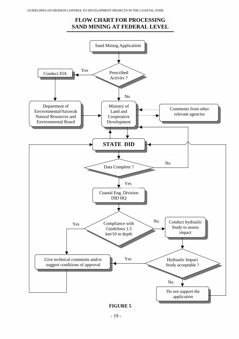
2.3.4.7 Flow Chart
The flow chart for processing sand mining applications is as shown in Figures4 and 5.
2.4 CONCLUSION
These guidelines are to be read together with the guidelines prepared in respect of themanagement plans for the other sectors in the National Coastal Resources Managementpolicy for example coastal forests; mangrove forests; aquaculture; fisheries;coastal/offshore sand mining; land use and water quality and tourism in processingdevelopment applications in the coastal zone in accordance with the GeneralAdministrative Circular No. 5 of 1987. It is to be reviewed when necessary to keepabreast with current technology in coastal engineering, Government policies and currentlegislation.
GUIDELINES ON EROSION CONTROL FO DEVELOPMENT PROJECTS IN THE COASTAL ZONE
- 14 -
Coastal Engineering DivisionDepartment of Irrigation and DrainageMalaysia

GUIDELINES ON EROSION CONTROL FO DEVELOPMENT PROJECTS IN THE COASTAL ZONE
FLOW CHART FOR PROCESSINGSHORE FRONT DEVELOPMENT
DevelopmentApplication
Conduct EIA
Department ofEnvironmental/SarawakNatural Resources andEnvironmental Board
Where Hydraulic Studis not required
DataComplete?
Coastal Eng. DivisiDID HQ
No
Yes
Yes
- 15 -
PrescribedActivity?
LOCALAUTHORITY/STATE GOVT.
Comments from otherrelevant agencies
y STATE DID Where Hydraulic Studyis required
on
Hydraulic Studycomplete with impact
assessment andmitigation measures?
Coastal Eng. DivisionDID HQ
Give technical commentsand/or suggest conditions
of approval
FIGURE 1
No
Yes
No

GUIDELINES ON EROSION CONTROL FO DEVELOPMENT PROJECTS IN THE COASTAL ZONE
FLOW CHART FOR PROCESSINGBACKSHORE DEVELOPMENT
DevelopmentApplication
Conduct EIA
Department ofEnvironmental/SarawakNatural Resources andEnvironmental Board
Where Hydraulic Studis not required
DataComplete?
Coastal Eng. DivisiDID HQ
No
Yes
Yes
- 16 -
PrescribedActivity?
LOCALAUTHORITY/STATE GOVT.
Comments from otherrelevant agencies
y STATE DID Where Hydraulic Studyis required
on
Hydraulic Studycomplete with impact
assessment andmitigation measures?
Coastal Eng. DivisionDID HQ
Give technical commentsand/or suggest conditions
of approval
FIGURE 2
No
Yes
No
GUIDELINES ON EROSION CONTROL FO DEVELOPMENT PROJECTS IN THE COASTAL ZONE
FLOW CHART FOR PROCESSINGLAND RECLAMATION
Land ReclamationApplication
Conduct EIA
Department ofEnvironmental/SarawakNatural Resources andEnvironmental Board
Yes
- 17 -
PrescribedActivity?
LOCALAUTHORITY/STATE GOVT.
Comments from otherrelevant agencies
STATE DID
Coastal Eng. DivisionDID HQ
Hydraulic Studycomplete with impact
assessment andmitigation measures?
Give technical commentsand/or suggest conditions
of approval
FIGURE 3
No
Yes
No
GUIDELINES ON EROSION CONTROL FO DEVELOPMENT PROJECTS IN THE COASTAL ZONE
FLOW CHART FOR PROCESSINGSAND MINING AT STATE LEVEL
Sand Mining Application
Conduct EIA
Department ofEnvironmental/SarawakNatural Resources andEnvironmental Board
Give technical cand/or suggest c
of appro
Yes
Yes
- 18 -
PrescribedActivity?
District LandOffice/State Dept.
of Land andMines
Comments from otherrelevant agencies
STATE DID
Data Complete?
Do not support theapplication
Hydraulic ImpactStudy acceptable?
Coastal Eng. DivisionDID HQ
ommentsonditionsval
FIGURE 4
No
No
Yes
No
Compliance withGuidelines 1.5km/10 m depth
No
Conduct hydraulic Studyto assess impact
Yes
GUIDELINES ON EROSION CONTROL FO DEVELOPMENT PROJECTS IN THE COASTAL ZONE
- 19 -
PrescribedActivity ?
FLOW CHART FOR PROCESSINGSAND MINING AT FEDERAL LEVEL
Sand Mining Application
Conduct EIA
Department ofEnvironmental/SarawakNatural Resources andEnvironmental Board
Ministry ofLand and
CooperativeDevelopment
Comments from otherrelevant agencies
STATE DID
Data Complete ?
Do not support theapplication
Hydraulic ImpactStudy acceptable ?
Coastal Eng. DivisionDID HQ
Give technical comments and/orsuggest conditions of approval
FIGURE 5
No
No
Yes
Yes
No
Yes
Compliance withGuidelines 1.5km/10 m depth
No Conduct hydraulicStudy to assess
impact
Yes
GUIDELINES ON EROSION CONTROL FO DEVELOPMENT PROJECTS IN THE COASTAL ZONE
- 20 -
APPENDIX 1
GENERAL ADMINISTRATIVE CIRCULAR NO. 5 OF 1987
PERATURAN MELULUS DAN /ATAU
MELAKSANAKAN PROJEK PEMBANGUNAN
DI KAWASAN PANTAI NEGARA

GUIDELINES ON EROSION CONTROL FO DEVELOPMENT PROJECTS IN THE COASTAL ZONE
- 21 -
Telefon: 23221957
Kawat: PEPDANA
Rujukan Kami: 0.93/380/7-IA/1
Tarikh: 10 September 1987
Ketua-Ketua Setiausaha Kementerian,
Y.B. Setiausaha-Setiausaha Kerajaan Negeri,
Ketua-Ketua Jabatan Persekutuan,
Ketua-Ketua badan Berkanun Persekutuan.
SURAT PEKELILING AM BIL. 5 TAHUN 1987
PERATURAN MELULUS DAN/ATAU MELAKSANAKANPROJEK PEMBANGUNAN DI KAWASAN PANTAI NEGARA
1. TUJUAN
1.1 Surat Pekeliling ini bertujuan untuk menetap dan menjelaskan peraturan yangperlu di patuhi oleh setiap Kementerian, Jabatan dan Badan Berkanun yang terlibat sertasemua Kerajaan Negeri ketika melulus dan/atau melaksanakan projek-projekpembangunan di kawasan pantai.
2. LATARBELAKANG
2.1 Sejak beberapa kebelakangan ini, hakisan pantai telah menyebabkan kerosakandan kemusnahan kepada kawasan pertanian, hutan paya bakau, perumahan, rangkaianjalan perhubungan dan pantai rekreasi. Daripada sepanjang 4,800 km. pantai di Negarakita ini, lebih kurang 1,300 km (atau 27%) sedang mengalami hakisan pantai.Anggaran kasar nilai harta benda yang terancam oleh fonomena semulajadi ini adalahkira-kira RM 200 juta untuk tempoh lima (5) tahun akan datang.
3. KAWALAN HAKISAN PANTAI NEGARA
3.1 Pengawalan ke atas kesan hakisan pantai Negara sekarang ini telah menjadi satukeperluan dari segi ekonomi dan sosial. Untuk tujuan ini, Kerajaan akan melaksanakanstrategi pengawalan hakisan pantai yang berbentuk dua peringkat. sebagai langkah
Jabatan Perdana Menteri Malaysia,Jalan Dato’ Onn,50502 Kuala Lumpur.
GUIDELINES ON EROSION CONTROL FO DEVELOPMENT PROJECTS IN THE COASTAL ZONE
- 22 -
jangka pendek, harta benda dan kemudahan awam di kawasan kritikal yang terancamoleh fenomena ini akan dilindungi, sekiranya didapati ekonomikal berbuat demikian.Langkah jangka panjang pula, adalah untuk mengawal kesan hakisan pantai melaluipenyelarasan perancangan dan pengawalan pembangunan di kawasan pantai secarabersepadu.
4. PELAKSANAAN STRATEGI
4.1 Untuk melaksanakan strategi ini Kerajaan telah, antara lain mengujudkan duainstitusi kawalan iaitu Majlis Kawalan Hakisan Pantai Negara (MKHPN) dan PusatTeknikal Kejuruteraan Pantai (PTKP).
4.2 Majlis Kawalan Hakisan Pantai Negara (MKHPN) adalah merupakan badanpenasihat mengenai kawalan hakisan pantai dan fungsi utamanya ialah untukmemperakukan kepada Kerajaan mengenai program, pembiayaan dan penyelarasantindakan, bukan sahaja di antara Kerajaan Persekuatuan dan Negeri tetapi juga dengansektor swasta. Pusat Teknikal Kejuruteraan Pantai (PTKP) pula telah ditubuhkan diJabatan Parit dan Taliair Malaysia dan bertanggungjawab untuk melaksanakan kajianteknikal dan memberi khidmat nasihat hakisan pantai.
4.3 Kajian Hakisan Pantai Negara yang telah dijalankan baru-baru ini menunjukkanbahawa kebanyakan kemusnahan yang berlaku adalah kerana pembangunan telahdilaksanakan di kawasan yang berpotensi untuk terhakis, dimana kerja-kerjakejuruteraan untuk pengawalan hakisan memerlukan perbelanjaan yang tinggi.Kemusnahan berlaku juga akibat pembinaan struktur-struktur yang tidak dirancang disepanjang pantai serta aktiviti-aktiviti di luar pantai yang telah menyebabkanberlakunya hakisan ataupun memburukkan lagi keadaan hakisan.
4.4. Sebagai langkah pertama kearah mengurangkan kesan hakisan pantai dan kospencegahannya, perlu dipastikan supaya segala usaha pembangunan di kawasan pantaiyang dilaksanakan di masa hadapan hendaklah mengambil kira kemungkinan risikohakisan serta kesan-kesan negatif lain yang mungkin timbul. Demikian juga denganpembinaan struktur-struktur di sepanjang pantai seperti jeti, pelabuhan, tembok penahandan lain-lain serta aktiviti-aktiviti di lautan berhampiran seperti pengambilan pasir,pembinaan pelantar minyak, pemasangan paip/kabel di dasar laut dan lain-lainhendaklah pada masa akan datang dirancang supaya tidak akan menyebabkan ataumemburukkan lagi hakisan pantai (contoh struktur/aktiviti pantai yang mungkindibina/dijalankan adalah seperti di Lampiran A). Sehubungan dengan ini setiapKementerian, Jabatan dan Badan Berkanun yang terlibat serta semua Kerajaan Negeriadalah dinasihatkan supaya merujukkan segala cadangan pembangunan, aktiviti danpembinaan struktur di kawasan pantai termasuk di lautan yang berhampiran, untukulasan kepada:
Ketua Pengarah,Jabatan Parit dan Taliair, Malaysia,Jalan Mahameru,50626 KUALA LUNTUR,( u.p: Pengarah, Pusat Teknikal Kejuruteraan Pantai )
GUIDELINES ON EROSION CONTROL FO DEVELOPMENT PROJECTS IN THE COASTAL ZONE
- 23 -
5. TANGGUNGJAWAB KETUA JABATAN
5.1 Dengan berkuatkuasanya Surat Pekeliling ini, Ketua-Ketua SetiausahaKementerian, Ketua-Ketua Jabatan, Ketua-Ketua Badan Berkanun yang terlibat sertasemua Setiausaha-Setiausaha Kerajaan Negeri adalah bertanggungjawab melaksanakanperaturan yang termaktub dalam Surat Pekeliling ini. Sebarang kemusykilan yangtimbul dari Surat Pekeliling ini hendaklah dirujukkan kepada:
Ketua Pengarah,Unit Penyelarasan Perlaksanaan,Jabatan Perdana Menteri,Jalan Dato' Onn,50502 KUALA LUNPUR
6. TARRKH KUATKUASA
6.1 Tarikh kuatkuasa peraturan ini adalah dari tarikh Surat Pekeliling ini.
"BERKHIDMAT UNTUK NEGARA"
( t.t.)
(TAN SPJ DATO' SALLEHUDDIN BIN MOHAMED)KETUA SETIAUSAHA NEGARA
Note:
Paragraph 4.4 line 16 should be changed to
Ketua Pengarah,Jabatan Pengairan dan Saliran, Malaysia,Jalan Sultan Salahuddin,50626 KUALA LUMPUR.(u/p: Pengarah,
Bahagian Kejuruteraan Pantai)
GUIDELINES ON EROSION CONTROL FO DEVELOPMENT PROJECTS IN THE COASTAL ZONE
- 24 -
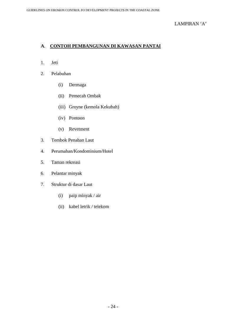
LAMPIRAN ‘A’
A. CONTOH PEMBANGUNAN DI KAWASAN PANTAI
1. Jeti
2. Pelabuhan
(i) Dermaga
(ii) Pemecah Ombak
(iii) Groyne (kemola Kekubah)
(iv) Pontoon
(v) Revetment
3. Tembok Penahan Laut
4. Perumahan/Kondominium/Hotel
5. Taman rekreasi
6. Pelantar minyak
7. Struktur di dasar Laut
(i) paip minyak / air
(ii) kabel letrik / telekom