guidefor master planningin...
TRANSCRIPT

GUiDe for master
PlanninG in Delawareseptember 2012
office of state PlanninG coorDination
stateplanning.delaware.gov
GUiDe for master
PlanninG in Delawareseptember 2012
office of state PlanninG coorDination
stateplanning.delaware.gov
with assistance from the
University of Delaware’s institUte for PUblic aDministration
with assistance from the
University of Delaware’s institUte for PUblic aDministration
MasterPlanningGuide_cover_cover 9/27/12 8:22 AM Page 1

GUIDE FOR MASTER PLANNING IN DELAWARE
September 2012

STATE OF DELAWARE
EXECUTIVE DEPARTMENT
OFFICE OF STATE PLANNING COORDINATION
122 William Penn Street Third Floor Dover, DE 19901
Phone (302)739-3090 Fax (302)739-5661 stateplanning.delaware.gov
September 24, 2012
Dear Delaware State Agencies and Local Governments:
I am pleased to present the Guide for Master Planning in Delaware developed by the Delaware
Office of State Planning Coordination with assistance from the Institute for Public
Administration at the University of Delaware.
Our office is working to develop a framework, called Complete Communities, which will include
guidelines for creating communities that can improve the quality of life for citizens and
encourage more economic development opportunities while minimizing the use of natural and
fiscal resources. In order to achieve these goals, we believe that Master Planning is one of the
cornerstones of good government land use activities. It complements the other planning
activities that are already ongoing. Local comprehensive plans formulate visions for each
jurisdiction’s future and articulate general guidelines for achieving desired land use patterns.
Master Planning brings all stakeholders—state agencies, local governments, civic groups, and
business leaders—together to actually implement certified comprehensive plans by spelling out
the details of, and the responsibilities for, the provision of infrastructure services in an efficient,
timely, and cost-effective manner.
We believe that the partnerships formed during Master Planning between state agencies and
our local governments and their citizens will contribute to a vision for Delaware that keeps it a
great place to live and work while supporting an environment that grows businesses and
preserves our critical natural and fiscal resources through sensible land–use planning practices.
Our planners stand ready to assist local governments and state agencies to develop and
implement Master Plan projects.
Sincerely,
Constance C. Holland, AICP Director
Guide for Master Planning in Delaware Table of Contents
September 2012 i
Table of Contents
What Is a Master Plan? ................................................................................................................... 1
Characteristics ........................................................................................................................... 1
Different from Local Comprehensive Plans .............................................................................. 1
When Is a Master Plan Needed?..................................................................................................... 2
How To Do a Master Plan ............................................................................................................... 3
Step 1. Identify Key Stakeholders .......................................................................................... 4
Step 2. Get Organized ............................................................................................................ 5
Step 3. Commit to Move Forward.......................................................................................... 6
Step 4. Assess Existing Conditions ......................................................................................... 7
Step 5. Involve the Public ....................................................................................................... 8
Step 6. Prepare Plan Draft.................................................................................................... 10
Step 7. Get Feedback on Plan Draft ..................................................................................... 12
Step 8. Adopt Plan ................................................................................................................ 13
Step 9. Implement Plan ........................................................................................................ 14
How Others Have Done Master Plans .......................................................................................... 15
Churchman’s Crossing Study ................................................................................................... 16
Westown Master Plan ............................................................................................................. 20
Eden Hill Farm Master Plan ..................................................................................................... 24
Southern New Castle County Infrastructure Master Plan ...................................................... 29
Milford Southeast Neighborhood Master Plan ...................................................................... 33
Georgetown South Area Master Plan ..................................................................................... 37
Lessons Learned ...................................................................................................................... 41
Appendix A. Memorandum of Agreement Example ................................................................. 42
Appendix B. Public-Engagement Tips ........................................................................................ 48
Appendix C. Stakeholder Commitments Example .................................................................... 50

Guide for Master Planning in Delaware What Is A Master Plan?
September 2012 1
What is a Master Plan?
A land use plan focused on one or more sites within an area that identifies access, general improvements and needed infrastructure, and intended to guide growth and development over a number of years and in phases.
Source: American Planning Association, APA Planners Dictionary, as amended by the Delaware Office of State Planning Coordination.
What Is a Master Plan?
Characteristics
Master Plans present opportunities
to enhance the lives of those who
either will or already live and/or
work in the project areas, especially
if “complete communities”
guidelines are used (as defined in the
2010 Delaware Strategies for State
Policies and Spending1).
Master Plans supplement, support, and help stakeholders implement comprehensive
plans.
Master Plans are collaborative undertakings among jurisdictions, agencies, service
providers, and infrastructure providers.
Master Plans are more detailed than comprehensive plans because they include build-
out calculations, identification of infrastructure needs and costs, and the phasing and
coordination of infrastructure provision with development.
Master Plans are meant to produce more predictable outcomes than comprehensive
plans and are thus seen as beneficial for economic development as well as
environmental protection and other efforts.
Master Plans earn public acceptance via public meetings and/or workshops.
Different from Local Comprehensive Plans
Master Plans differ from “local comprehensive plans” mandated by the Delaware Code in Title 9
for counties and in Title 22, Section 702 for municipalities. Delaware law prescribes the
contents of comprehensive plans and the frequency with which they are to be reviewed or
adopted. As a result, comprehensive plans represent general guidelines for growth and
development. Making the road improvements, extending the water and sewer lines, or
transferring the development rights to implement a comprehensive plan are undertakings that
a local jurisdiction frequently cannot accomplish on its own. It requires collaboration with
other governments, service providers, and the community.
1 For additional information, see http://stateplanning.delaware.gov/strategies/default.shtml.

Guide for Master Planning in Delaware When Is A Master Plan Needed?
September 2012 2
When Is a Master Plan Needed?
There are a variety of situations in which creating a
Master Plan would be helpful. So, how do you know that
you need a Master Plan? You need a Master Plan when
you realize that you must do more detailed planning for
infrastructure than is provided for in your comprehensive
plan. You need a Master Plan when you realize that you
can’t go it alone (e.g., you need a master plan when the municipality next door is responsible
for your sewage treatment).
What sorts of situations might trigger the need for a Master Plan? Here are some examples.
While updating a comprehensive plan, a town planner realizes that in order to annex a
property adjacent to the town, an extension to the county sewer is needed.
A developer presents a concept for a traditional neighborhood development that
includes properties in a municipality and an adjacent county.
A proposal for infill development requires improvements to streets and roads not
controlled by the town.
Your town has annexed a 200-acre parcel adjacent to a major highway and wants to
make the site shovel-ready for economic development.
A major employer, who is also a large-water user, announces plans to triple its
workforce over the next five years.

Guide for Master Planning in Delaware How to Do a Master Plan
September 2012 3
How To Do a Master Plan

Guide for Master Planning in Delaware Step 1. Identify Key Stakeholders
September 2012 4
Step 1. Identify Key Stakeholders
Once it is determined that a Master Plan is needed, the first
step is to identify the persons, groups, or organizations that
can help solve the problem—the stakeholders.
Stakeholders should include high-level, elected officials and
administrators from the local jurisdictions and organizations
affected by the plan as well as appropriate state
departments and agencies. These representatives should be persons who are authorized to
commit resources to the Master Plan effort and make decisions on behalf of the agencies they
represent. Their participation provides an incentive for other stakeholders to attend and
participate. Although the composition of stakeholder groups should be tailored to each Master
Plan, the list below provides a starting point.
Local Representation—Mayor, municipal manager, planning staff, council members,
planning commission, business organizations, fire companies, school districts, civic
groups, citizens
State Agency Representation—Office of State Planning Coordination (OSPC);
Departments of Agriculture (DDA), Education (DDOE), Natural Resources and
Environmental Control (DNREC), and Transportation (DelDOT); State Housing Authority
(DSHA); and Economic Development Office (DEDO)
Community leaders from business and civic groups
Stakeholders must agree to assume responsibility for participation in the project and
implementation of infrastructure and service decisions. Responsibilities should be described,
and a formal agreement should be made to solidify commitment from each stakeholder. An
effective way to solidify stakeholder responsibilities is through a Memorandum of Agreement
(MOA).
Step 1 Identify Key Stakeholders Step 2 Get Organized Step 3 Commit to Move Froward Step 4 Assess Existing Conditions Step 5 Involve the Public Step 6 Prepare Plan Draft Step 7 Get Feedback on Plan Draft Step 8 Adopt Plan Step 9 Implement Plan

Guide for Master Planning in Delaware Step 2. Get Organized
September 2012 5
Step 2. Get Organized
The purpose for this step is to bring together the
stakeholders identified in Step 1 in order to determine how
the Master Plan effort should go forward.
Flesh out the problem. To a certain extent, it will
involve describing existing conditions in the project
area.
Delineate the extent of the Master Plan project area.
Ascertain stakeholder commitment.
Determine stakeholder responsibilities and contributions to the project.
Do a first cut of a vision for the Master Plan area.
Determine how the project will be managed. The project should be managed by a
professional planner or someone with considerable knowledge of planning. A paid
consultant is preferred. If this alternative is chosen, stakeholders must determine who
will fund the consultant’s work. Another approach is for OSPC to lead the project.
It is expected that some of this analysis will have been done when identifying the need for a
Master Plan (see page 2). It is also to be expected that the plan initiator will have developed a
preliminary concept of the project area, the end-state land use pattern, etc.
Consider the following guidelines when establishing boundaries for the Master Plan area.
Project area boundaries should not be constrained by municipal or county boundaries.
Rather, the geographical extent of the planning issues should determine the area to be
incorporated into the Master Plan.
Bigger is not always better. It is often difficult to achieve detailed infrastructure
planning for large areas.
To the extent feasible, Master Plan–area boundaries should respect established analysis
areas for which data are available, such as census tracts, traffic analysis zones, and
watersheds.
Step 1 Identify Key Stakeholders Step 2 Get Organized Step 3 Commit to Move Froward Step 4 Assess Existing Conditions Step 5 Involve the Public Step 6 Prepare Plan Draft Step 7 Get Feedback on Plan Draft Step 8 Adopt Plan Step 9 Implement Plan

Guide for Master Planning in Delaware Step 3. Commit to Move Forward
September 2012 6
Step 3. Commit to Move Forward
All Master Plans should have a signed Memorandum of
Agreement (MOA). A signed MOA demonstrates
commitment by the stakeholders to participate in the effort
and assume their responsibilities in the implementation of
the plan’s recommendations. The following list recommends
elements that an MOA document should include.
A clear description of the situation that identified the
need for a Master Plan.
Scope of work that includes key components of the project. These may change as the
project develops.
A map of the project area. As with the scope of work, this may change as the project
develops.
A schedule with milestones.
A strategy for “getting the work done” that outlines responsibilities, funding, and staff
commitments for each stakeholder identified in Step 1.
Designation of a project manager.
The MOA for the Milford Southeast Neighborhood Master Plan is presented in Appendix A as an
example. The “Whereas” statements on pages 42 and 43 identify the issues that prompted
initiation of the Master Plan. The “Be It Resolved” statements on pages 43-45 outline the
stakeholder responsibilities. Stakeholder signatures are found on page 46. The initial Master
Plan project area boundaries are depicted in the appendix to the MOA on page 47.
Step 1 Identify Key Stakeholders Step 2 Get Organized Step 3 Commit to Move Froward Step 4 Assess Existing Conditions Step 5 Involve the Public Step 6 Prepare Plan Draft Step 7 Get Feedback on Plan Draft Step 8 Adopt Plan Step 9 Implement Plan

Guide for Master Planning in Delaware Step 4. Assess Existing Conditions
September 2012 7
Step 4. Assess Existing Conditions
This step is about providing further detail regarding existing
conditions in the Master Plan area that was begun in Step 2.
This effort should include gathering data and mapping the
existing conditions of the study area. It is important to
organize this information in a manner that will be easily
understood when involving the public in Step 5.
Data collection and mapping should rely as much as possible on existing data. Each stakeholder
agency should provide pertinent informational data and GIS (geographic information systems)
mapping data already prepared for other projects. Local government officials should contribute
information and GIS mapping compiled for comprehensive plans.
Below are suggestions for organizing and putting together the study area’s existing conditions.
Data
– Socio-economic characteristics, such as population, housing, income, age,
educational attainment, occupation; important to show trends as well as present
current statistics
– A list of the key stakeholders identified in Step 1 and community groups and other
interested parties not identified in Step 1
– An inventory of service providers in the project area
– Existing and proposed capacities of area infrastructure
Maps
– Residential—Housing types, existing and planned subdivisions
– Farmland—Areas being farmed and those in farmland-preservation programs
– Community Facilities—Parks, schools, public safety, libraries, community centers,
health care, social services
– Natural and Environmental—Rivers, streams, water bodies, floodplains, wetlands,
source water protection areas, and protected natural areas such as wildlife areas,
trails
– Employment—Retail, service, manufacturing, public, agri-businesses, major
employers
– Infrastructure—Roads, water, sewer, gas, electricity, communications (telephone,
broadband, fiber optics)
Step 1 Identify Key Stakeholders Step 2 Get Organized Step 3 Commit to Move Froward Step 4 Assess Existing Conditions Step 5 Involve the Public Step 6 Prepare Plan Draft Step 7 Get Feedback on Plan Draft Step 8 Adopt Plan Step 9 Implement Plan

Guide for Master Planning in Delaware Step 5. Involve the Public
September 2012 8
Step 5. Involve the Public
The public-engagement process is intended to obtain input
that will guide the creation of a Master Plan. Its goal is to
create an environment in which the public can:
Voice their opinions.
Help formulate the future of the project area.
Be invested in the outcome.
Support actions needed to implement the plan.
Project leaders must emphasize that all ideas are appreciated and will be considered, but the
implementation strategy is a process of consensus. Considerable time should be given to
hearing what participants have to say. It may take a series of meetings and workshops to
ensure that all public comment has been received.
Getting Started
The public-engagement process should begin with a meeting or workshop in which the
following information is presented to the public. It is recommended that this information be
outlined in a written handout and presented verbally at the beginning of an initial meeting.
Description of the situation that initiated the Master Plan effort and a map of the
Master Plan area
An introduction of the stakeholders and their commitments to the project
Information on existing conditions
Overview of the remainder of the process
Visioning
One of the most difficult aspects of any planning exercise is to get participants to articulate
their preferred future. Project leaders must continually encourage participants to think beyond
their immediate neighborhood and focus on the entire project area. Another challenge is to get
participants to envision an end-state or a scenario more than a few years into the future.
Try Something Different
Alternative public-participation processes should be considered, especially technology-driven
techniques. These provide another way of getting people engaged, since it appears that there
is less public interest in Master Plan meetings and workshops than in meetings or workshops
for local comprehensive plans.
Step 1 Identify Key Stakeholders Step 2 Get Organized Step 3 Commit to Move Froward Step 4 Assess Existing Conditions Step 5 Involve the Public Step 6 Prepare Plan Draft Step 7 Get Feedback on Plan Draft Step 8 Adopt Plan Step 9 Implement Plan

Guide for Master Planning in Delaware Step 5. Involve the Public
September 2012 9
One framework for community engagement is the charrette. A charrette is a process that has
been utilized for the design of a number of new communities. Charrettes are also used to
address issues related to sustainability planning, regional planning, community planning, and
transportation planning.2 They are characterized by sustained and intense efforts to produce a
solution to a planning problem. They often involve multiple sessions over a number of
subsequent days (and sometimes nights). Participants typically include government officials,
consultants, and the public. The charrette typically closes with a presentation of a document or
design that includes implementation strategies.
A tool for public engagement that could be
employed within the charrette framework or any
other public-engagement format is
CommunityViz®. CommunityViz® is an interactive
GIS (geographic information systems) software
application that can generate “what if” land use
scenarios.3 Using CommunityViz®, the University
of Delaware’s Sustainable Coastal Communities
Initiative4 program staff developed a land use
model for Sussex County. The county was divided
into 100-acre grids, or tiles, to illustrate potential
development patterns. The grid configuration is used instead of parcel boundaries, natural
features (such as streams), or man-made features (such as roads) to take away some of the
personal aspects of the land use–planning process. Each grid represents a typical land use, such
as rural, suburban, urban, mix of suburban and urban, and non-residential.
The interactive nature of CommunityViz® permits participants to change land uses by painting
tiles with electronic crayons representing the land uses that they would like to see in the future.
The re-coloring process can be done quickly, allowing participants to create any number of
alternative development scenarios at a single meeting or workshop. The scenarios can be
discussed, analyzed, combined, and displayed in a three-dimensional format.
Tips for Success
Regardless of what mechanisms are used, it is important to reach out to the entire community.
See Appendix B on page 48 for tips to ensure a successful public-engagement experience.
2 For additional information, see www.charretteinstitute.org.
3 Community Viz
® is an ArcGIS software extension from Placeways, LLC. For additional information about using
CommunityViz® for public participation and development of planning scenarios, see Doug Walker and Tom Daniels,
The Planners Guide to CommunityViz, (Chicago: American Planning Association, 2011). 4 For additional information, see www.scc.udel.edu.

Guide for Master Planning in Delaware Step 6. Prepare Draft Plan
September 2012 10
Step 6. Prepare Plan Draft
This step involves writing and assembling maps for an initial
draft of the plan.
Before putting together the plan document, the
stakeholders must come together to consider the public
input, existing conditions, and the end-state visions
developed in Step 5. They must work collaboratively to
develop the desired future land use pattern and determine the infrastructure required to
service it.
Below are some general considerations regarding the organization and contents of the Master
Plan document.
Consider having the initial draft of each chapter or major section of the plan authored
by the stakeholder who contributed to plan. For example, a DNREC representative
might be tasked with drafting the environmental element of the plan.
The project manager named in Steps 2 and 3 should serve as editor and assembler of
the draft document.
Use charts, tables, graphics to illustrate and organize information in plan document.
Plan Elements
Although the organization and format of each Master Plan should be tailored to the issues of
the study area, the document should include text, maps, and graphics and contain at least the
following:
Description of the issues that prompted the need for a Master Plan and delineation of
study area
Description of the preferred end-state—how the project area might look if developed in
accordance with the Master Plan recommendations
Description of the public-outreach process and how the input from public outreach was
incorporated into plan recommendations
Future land use element with map and text
Other plan elements such as housing, agricultural preservation, environmental
protection, historical and cultural preservation, transportation, water and sewer, design
guidelines. Each element should consist of text and maps
Step 1 Identify Key Stakeholders Step 2 Get Organized Step 3 Commit to Move Froward Step 4 Assess Existing Conditions Step 5 Involve the Public Step 6 Prepare Plan Draft Step 7 Get Feedback on Plan Draft Step 8 Adopt Plan Step 9 Implement Plan

Guide for Master Planning in Delaware Step 6. Prepare Draft Plan
September 2012 11
An implementation element that:
– Describes actions to carryout plan recommendations
– Outlines stakeholder commitments
– Include mechanisms to monitor plan implementation
Plan Details
This aspect distinguishes Master Plans from comprehensive plans. Local comprehensive plans
contain goals, visions, and relatively general strategies for implementing those goals and
visions. Master Plans must be more specific than comprehensive plans by filling in the details.
The table below illustrates how the detailed implementation components of a Master Plan
might differ from those of a typical comprehensive plan.
Comprehensive Plan Master Plan
A sewer extension may be required for the development of the XYZ area.
Approximately 2,500 lineal feet of 12-inch sewer must be in place prior to approval of a development plan for the XYZ area. The Town of Delapolis commits to designing and constructing this sewer line and will include this project in the town CIP (Capital Improvements Program) for Fiscal Years 2013-2018.
Consider using TDRs (transfer of development rights) to increase density in undeveloped residential areas.
Development rights at 4 dwelling units per acre, calculated by Delaware Department of Agriculture (DDA), can be transferred from Parcels A, B, or C to increase the density on Parcel D from 4 dwellings per acre to a maximum of 8 dwellings per acre. The town will amend the Delapolis Land Use and Development Code to permit this density increase.
Appendix C on page 51 uses language from the Milford Southeast Neighborhood Master Plan to illustrate further the level of detail that Master Plans should incorporate.

Guide for Master Planning in Delaware Step 7. Get Feedback on Draft Plan
September 2012 12
Step 7. Get Feedback on Plan Draft
After writing the draft, share the details of the work done in
Step 6 with the public, stakeholders, and relevant parties. It
is important for the public to know that the plan drafters
listened to them.
Explain how the existing conditions, public input, and
alternative scenarios were analyzed to formulate the
recommendations in the plan document draft.
Get feedback on the choices included in the plan document.
Although the format of public input on the plan draft may differ from the format utilized in the
initial public outreach, make sure that the public has ample opportunity to review, analyze, and
comment on it. It may require a number of meetings or workshops to accomplish this. It is
recommended that these workshops be conducted by one of the participating local jurisdictions
or a joint meeting could be hosted by several participating jurisdictions.
The draft plan should also be submitted
to OSPC for PLUS (Preliminary Land Use
Service) review.
If input from the public workshops,
hearings, or PLUS review held in Step 6
reveal the need for substantial
alterations, changes in policy direction,
etc., it might be necessary to do another
draft (return to Step 5) and initiate
another round of public-participation
efforts.
Step 1 Identify Key Stakeholders Step 2 Get Organized Step 3 Commit to Move Froward Step 4 Assess Existing Conditions Step 5 Involve the Public Step 6 Prepare Plan Draft Step 7 Get Feedback on Plan Draft Step 8 Adopt Plan Step 9 Implement Plan

Guide for Master Planning in Delaware Step 8. Adopt Plan
September 2012 13
Step 8. Adopt Plan
This step involves assessing and incorporating feedback on
the plan draft into a final document and adopting the plan.
The final plan should be amended based on feedback
from the public review.
The final plan should point out how the plan was
changed as a result of feedback on the plan draft. It
is recommended that this information be placed in an appendix.
The Master Plan should be adopted in a formal manner by the local government(s) with
jurisdiction. The preferred method is adoption as an amendment to applicable local
comprehensive plan(s).
Step 1 Identify Key Stakeholders Step 2 Get Organized Step 3 Commit to Move Froward Step 4 Assess Existing Conditions Step 5 Involve the Public Step 6 Prepare Plan Draft Step 7 Get Feedback on Plan Draft Step 8 Adopt Plan Step 9 Implement Plan

Guide for Master Planning in Delaware Step 9. Implement Plan
September 2012 14
Step 9. Implement Plan
No plan is meaningful unless it is implemented. Needless to
say, the pace of development, changing consumer
preferences, and marketing conditions will control the pace
at which the plan is implemented and will no doubt prompt
adjustments to even the most thorough Master Plan.
Below is what needs to happen after Master Plan adoption.
Decisions, recommendations, and strategies contained in the Master Plan should be
incorporated into appropriate county and municipal comprehensive plans. This could
be combined with the Master Plan adoption process in Step 8.
Infrastructure-improvement projects should be incorporated into state and local capital
improvement programs and budgets.
Local governments should adopt the zoning, subdivision, and other land use regulations
needed to implement the plan’s recommendations.
Agreements between jurisdictions and service providers should be made to determine
timing and cost-sharing aspects of delivering or extending the services called for in the
Master Plan.
Periodic reports should be made that chronicle the progress made to implement plan
recommendations.
– OSPC staff might be tasked with this responsibility.
– The reports should be distributed to stakeholders and community leaders.
– Consideration should be given to conducting periodic public meetings to share this
information.
Step 1 Identify Key Stakeholders Step 2 Get Organized Step 3 Commit to Move Froward Step 4 Assess Existing Conditions Step 5 Involve the Public Step 6 Prepare Plan Draft Step 7 Get Feedback on Plan Draft Step 8 Adopt Plan Step 9 Implement Plan

Guide for Master Planning in Delaware How Others Have Done Master Plans
September 2012 15
How Others Have Done Master Plans
This section of the guide chronicles
several Delaware Master Plan projects.
As this section demonstrates, Delaware
Master Plans come in a variety of shapes
and sizes. As pointed our earlier, county
and municipal comprehensive plans are
constrained by jurisdictional boundaries,
but Master Plan boundaries have been
tailored to the specific issues and project
boundaries of each area. Some include
more than one local government, as did
the Southern New Castle County
Infrastructure Master Plan or the Milford
Southeast Neighborhood Master Plan.
Others encompass areas within a county
or municipality such as Churchman’s
Crossing in New Castle County, Eden Hill
Farm in the City of Dover, or Westown in
the Town of Middletown.

Guide for Master Planning in Delaware Churchman’s Crossing Study
September 2012 16
Churchman’s Crossing Study

Guide for Master Planning in Delaware Churchman’s Crossing Study
September 2012 17
Getting Started
The Churchman’s Crossing area is a suburban area consisting of between five and six square
miles located at the crossroads of Interstate Route 95 and State Route (SR) 1. It is also within
Amtrak’s heavily traveled Northeast Corridor. The area includes a major employment center
north of I-95 and a regional retail center south of I-95 at Christiana Mall. Its boundaries are
entirely within New Castle County.5 The graphic below shows the boundaries of the study area
and identifies the project’s key stakeholders.
Step 1. Identify Key Stakeholders
The key stakeholders for this project were DelDOT, New Castle County, WILMAPCO, and the
residents, employers and employees of the Churchman’s Crossing area.
5 For additional information including periodic status reports on this project, see Churchman’s Crossing Area
Monitoring at www.deldot.gov/information/projects/churchmans_cross.

Guide for Master Planning in Delaware Churchman’s Crossing Study
September 2012 18
Step 2. Get Organized
The Churchman’s Crossing area of New Castle County had been a focal point for development
since the mid-1970s. Factors leading to this development pressure included impacts related to
the I-95 and SR 1 interchange, Christiana Care Medical Facility, Christiana Mall, Delaware
Technical Community College, and numerous other office and commercial land uses. The
purpose of the study was as follows:
Clarify the vision for Churchman’s Crossing.
Develop a transportation/land use plan that supports the vision.
Assess whether to create a transportation-improvement district that would:
– Meet the unique needs of the area.
– Augment public-sector investment.
Continue a public/private partnership.
Project area boundaries include:
North—Kirkwood Highway (SR 2)
East—Limestone Road (SR 7) and SR 1
South—SR 273 and Old Baltimore Pike
West—Salem Church Road and Red Mill Road
Step 3. Commit to Move Forward
A formal MOA was not executed for this project.
Step 4. Assess Existing Conditions
The data-collection and mapping activities for this project were a joint effort among DelDOT,
New Castle County, and WILMAPCO. Information gathering was completed in the summer of
1995, strategies were established in the fall of 1995, and transportation/land use options were
identified also in the fall of 1995. The stakeholders were responsible for supplying the
appropriate data for conducting the analysis of transportation options.
Step 5. Involve the Public
On July 19, 1995, a public workshop was held to present background information and to solicit
input for the development of a vision for Churchman’s Crossing. A second public workshop was
held on February 16, 1996, to discuss an analysis of transportation and land use options.
Step 6. Prepare Plan Draft
In the fall of 1996, findings and recommendations were prepared.
Guide for Master Planning in Delaware Churchman’s Crossing Study
September 2012 19
Step 7. Get Feedback on Plan Draft
Following publication of the findings and recommendations in the fall of 1996, a public
workshop was held.
Step 8. Adopt Plan
On April 1, 1997, the Churchman’s Crossing Study Final Report presented a package of
recommendations involving transportation and land use components for the Churchman’s
Crossing area. The study recommendations were to be adopted by the stakeholders through
their respective comprehensive plan updates, transportation-improvement programs, and
capital-improvement programs.
Step 9. Implement Plan
According to the 1997 study mentioned earlier, “The implementation of the package of
improvements will require careful coordination between DelDOT, New Castle County,
WILMAPCO, and the residents, employers and employees of Churchman’s Crossing. The
recommendations in this document are a starting point for that cooperative effort.”
Furthermore, they were also responsible for including the implementation recommendations
into their respective codes, plans, and budgets. According to the Phase 2 Report, the following
commitment was indicated:
The study recommendations will be considered in the development of DelDOT’s Capital Improvement Program (CIP), WILMAPCO’s Transportation Improvement Program (TIP) and Metropolitan Transportation Plan (MTP) and the New Castle County Comprehensive Development Plan Update. The Study recommendations provide both a short term and long range conceptual plan for dealing with land use and transportation issues in Churchman’s Crossing. The recommendations have not been assessed or tested with respect to federal, state and local environmental requirements. That analyses/evaluation will occur during the next phase of the project.
Evaluation and follow-up to the study recommendations have taken place through the periodic
update of the county comprehensive plan and the yearly preparation of WILMAPCO’s
Transportation Improvement Program and DelDOT’s Capital Improvement Program.
Since 1997, many transit, intersection, roadway, pedestrian, and bicycle projects have been
planned, designed, and constructed in the Churchman’s Crossing area.

Guide for Master Planning in Delaware Westown Master Plan
September 2012 20
Westown Master Plan

Guide for Master Planning in Delaware Westown Master Plan
September 2012 21
Getting Started
The Westown Master Plan area is located in the southwest quadrant of Middletown, west of
the Norfolk-Southern Railroad and south of SR 299 in the vicinity of U.S. Rt. 301. When the plan
was first introduced to the Middletown mayor and council, most of the study area was within
the corporate limits of Middletown. Since then, almost the whole study area has been annexed
into the town.
Step 1. Identify Key Stakeholders
Key stakeholders included a group of landowners (described in the previous section) proposing
development plans for the Westown area, the Town of Middletown, and DelDOT. Unlike many
other Master Plan approaches, the Westown Master Plan was initiated by the private sector.
The landowners chose this type of path because they believed that the best way to make their
plans possible was to present not only land uses, but also to delineate the infrastructure
improvements needed to support it.
Step 2. Get Organized
The challenge was determining how the then largely undeveloped southwestern quadrant of
Middletown south of SR 299 and east of the railroad should be developed. Another factor
affecting development in this area was the planned extension of U.S. Route 301 from SR 1 to
the Maryland State Line. In 2003, a development concept for 1,100 acres submitted to the
town. Because much of the area was undeveloped or sparsely developed in 2003, an
opportunity existed for a comprehensive approach to development of the entire area, and the
provisions of the services to support it, as opposed to a project-by-project review.
An interesting aspect of the Westown plan was that it is located within the boundaries of the
Southern New Castle County Infrastructure Master Plan area. It is a Master Plan area within a
Master Plan area.
Step 3. Commit to Move Forward
There was no formal agreement or MOA as part of the review process for this project. As will
be shown later, an implementation agreement was executed.
Step 4. Assess Existing Conditions
Most of the data and mapping was done by the group of private developers.
Step 5. Involve the Public
Much discussion about development in the Westown area occurred during the public outreach
held in conjunction with Middletown’s 2002 Comprehensive Plan Update. The 2005 plan and
the proposed 2011 updates continued discussion of the Westown plan.

Guide for Master Planning in Delaware Westown Master Plan
September 2012 22
Step 6. Prepare Plan Draft
Following adoption of Middletown’s 2002 Plan Update, a group of landowners prepared a
development application in the form of a Master Plan for properties in the Westown area.
Similar to a Master Plan, the application depicted land uses for defined areas within Westown
and showed conceptually where roads might be extended or improved to support the proposed
land uses. It also identified agricultural parcels that might be considered for TDR sending areas
and corresponding receiving areas. At least three receiving areas were identified as suitable for
traditional neighborhood design. Open space was also shown.
Step 7. Get Feedback on Plan Draft
Public input was received via workshops led by the Town.
Step 8. Adopt Plan
For purposes of this analysis, the plan could be considered published when a tri-party
agreement for coordinating private construction and infrastructure improvements was
executed by the Town of Middletown, the private developers, and DelDOT. This agreement
outlines how private construction will be coordinated with the provision of roads and other
infrastructure. To date, a portion of the planned development and accompanying
improvements have taken place.
Step 9. Implement Plan
Following up on submission of the Westown Master Plan, the Westown Circulation Plan was
reviewed by the PLUS committee in June 2005. This plan provided detail on the types of
transportation improvements needed to support the land uses proposed in the Master Plan.
To date, a portion of the planned development and accompanying improvements have taken
place in accordance with the tri-party agreement. The CTP Westown Transportation
Improvement Program (T200512801) project provides for “the coordination of private
development construction and necessary infrastructure improvements, including public
utilities.”
The map on the following page depicts the status of selected development projects in the
Westown area as of December 2011. Evaluation and adjustments are anticipated as the area
continues to develop and the market shapes the pace of development.

Guide for Master Planning in Delaware Westown Master Plan
September 2012 23
Status of Selected Westown Master Plan Projects
Source: Westown Ventures et al., Westown Master Plan A Livable Delaware Initiative, Land Use Planning Act Report to accompany rezoning, subdivision and development plan application for various properties located on the west side of the Town of Middletown, May 2003, base map edited by IPA to portray status of selected development plans included in the pending 2011 Middletown Comprehensive Plan.

Guide for Master Planning in Delaware Eden Hill Farm Master Plan
September 2012 24
Eden Hill Farm Master Plan

Guide for Master Planning in Delaware Eden Hill Farm Master Plan
September 2012 25
Getting Started
Eden Hill Farm is situated entirely within the City of Dover corporate limits. It is bounded on
the north by West North Street, on the east and south by the Delmarva Secondary Track (a rail
line operated by Norfolk-Southern), and on the west by Kraft Foods.
The farm represented one of the last possible alignments for the West Dover Connector. The
concept of this roadway had been included in most of Dover’s comprehensive plans since the
1960s. While the land was being farmed, an alignment for the Connector through the property
was not feasible. Then, in the early 2000s, the farm’s owners decided to sell the property.
Knowing that a traffic study and access approvals would be needed to develop the property,
the owner’s real estate broker contacted DelDOT. DelDOT hired Wallace Roberts & Todd, a
planning firm with considerable experience in Traditional Neighborhood Design (TND), to guide
them and the property owners through the process of developing a site design for the property
that would provide site access, accommodate regional traffic, and include the residential
development that the owners desired.
Step 1. Identify Key Stakeholders
Key stakeholders included the owners of the Eden Hill Farm, DelDOT, and the City of Dover.
OSPC was also involved.
Step 2. Get Organized
Early in the process, DelDOT, the property owners, and the consultant undertook the following:
Vision and Concept—Developed to help the property owners feel comfortable going
forward with development plans.
Concept Plan—Identified location for the connector road and portions of the Eden Hill
Farm to be preserved.
Market Study—Included analysis of demand and estimated pace of product absorption.
At the same time, the City of Dover, aware of the owners’ desire for something other than
industrial uses, was updating the comprehensive plan. A survey conducted for the 2003 Dover
comprehensive plan update indicated that heavy industry might not be the best use for the
property, and a concept incorporating a mix of commercial, employment, and residential uses
in a neo-traditional design was preferred. The extension of Saulsbury Road at least to New
Burton Road was also supported.

Guide for Master Planning in Delaware Eden Hill Farm Master Plan
September 2012 26
The study area consisted of the boundaries of the 265-acre farm shown in the graphic below.
The boundaries of the study area remained the same for the duration of the project.
Step 3. Commit to Move Forward
The commitment to move forward clearly came from the results of a series of workshops held
by the City of Dover in conjunction with the comprehensive plans of 1996, 2003, and 2008.

Guide for Master Planning in Delaware Eden Hill Farm Master Plan
September 2012 27
Step 4. Assess Existing Conditions
Data collection and mapping were assembled by the following.
The Dover planning staff collected the data and developed maps in conjunction with the
2003 Comprehensive Plan, which designated mixed use for the farm.
Following adoption of the 2003 comprehensive plan, Becker Morgan Group, an
architectural and engineering firm, prepared the site layout and pattern book of
architectural standards accompanying the rezoning application to place the property in
the TND Zone.
DelDOT provided maps and data in connection with the West Dover Connector project.
Step 5. Involve the Public
While preparing for the 2003 comprehensive plan update, the planning staff held several
workshops to revisit and determine whether findings of a 1996-1997 questionnaire remained
valid. One of the 2003 findings was that the community no longer supported industrial uses for
the Eden Hill Farm; a mixed-use traditional neighborhood design was preferred. The public was
also engaged through the process of drafting and adopting the standards for the TND zoning
district, through the rezoning process from IPM (Industrial Park Manufacturing) to TND, and
finally through the subdivision-review and -approval process for the Eden Hill Farm subdivision.
Step 6. Prepare Plan Draft
The recommendation for a traditional neighborhood development concept for Eden Hill was
included in the 2003 update to Dover’s comprehensive plan. On behalf of the developer, the
Becker Morgan Group designed the subdivision plan and pattern book. The comprehensive
plan was an initial step to recognize the land use change to mixed use, but the creation of the
subdivision plan truly represents the “design” component of the master plan for this property.
The pattern book goes one step further by addressing urban design and architectural elements
for the development.
Step 7. Get Feedback on Plan Draft
The Eden Hill plan was one of many ideas presented in the hearings and workshops held in
conjunction with the adoption of Dover’s 2003 comprehensive plan update. Feedback from the
public was also received through the process of drafting and adopting the TND zoning district,
through the rezoning process from IPM to TND, and finally through the subdivision-review
and -approval process for the Eden Hill Farm subdivision.
Step 8. Adopt Plan
The final plan could be considered to have been adopted when the concept for Eden Hill and
the steps needed to implement it were adopted as part of the 2003 comprehensive plan

Guide for Master Planning in Delaware Eden Hill Farm Master Plan
September 2012 28
update. The city subsequently engaged in the process of creating the TND Zone with the Eden
Hill area in mind. Alternatively, the plan could be considered adopted when the property was
rezoned from industrial to traditional neighborhood design (TND) in 2005. The rezoning action
included approval of the General Overall Master Plan for Eden Hill Farm and the adoption of a
Comprehensive Design Standards Manual, a pattern book of architectural styles. The 2008
comprehensive plan6 update continues the city’s commitment to the Eden Hill Farm Master
Plan.
Step 9. Implement Plan
Implementation of the Master Plan for Eden Hill Farm is underway. Below are some
milestones.
2003 Recommendation for zoning district that would permit mixes of residential and commercial uses, encourage pedestrian-friendly environments, and flexible bulk standards for lot sizes, building placement, and parking locations
2004 Adoption of new TND Zoning District
2005 Rezoning to TND, including approval of the Master Plan and pattern book
2007-2008 Infrastructure improvements
2008 Beginning of construction on first housing units and opening of Eden Hill Medical Center
2008-Present Refinements and amendments to pattern book and Master Plan layout as
construction continues
Continual evaluation is taking place as the property develops. From time to time, the City
adopts amendments to the plan layout and the pattern book. For each revision or amendment,
a thorough staff report is prepared that outlines details of the current application, provides
background on past applications and plan amendments, and makes recommendations.
In addition, meetings on the West Dover Connector began in January 2004. This project (CTP
T200411701) calls for the extension of Saulsbury Road (SR 15) along the eastern boundary of
Eden Hill Farm to U.S. Route 13.
6 For additional information, see www.cityofdover.com/Comprehensive-Plan-4005.

Guide for Master Planning in Delaware Southern New Castle County Infrastructure Master Plan
September 2012 29
Southern New Castle County Infrastructure Master Plan

Guide for Master Planning in Delaware Southern New Castle County Infrastructure Master Plan
September 2012 30
Getting Started
This Master Planning project is located in southern New Castle County, extending from the
Chesapeake and Delaware Canal to the Kent County border. It also includes the towns of
Middletown, Odessa, and Townsend (often referred to collectively as MOT). Before the
economic downturn beginning in 2008, this area was one of the fastest developing sections of
New Castle County. Development pressures were evident in Middletown and, to some extent,
Townsend and the unincorporated areas north and east of SR 299. The type of development
was mostly residential but also included commercial, office uses, and industrial uses especially
in the Middletown area. To service these areas, both New Castle County and Middletown
made major infrastructure improvements both in transportation and sanitary sewer facilities.
This development activity created considerable need for the construction of additional
educational facilities. Between 2001 and 2008, seven new schools opened in the
Appoquinimink School District alone. Three other school districts, Colonial, Smyrna, and the
New Castle County Vocational School District, were also being impacted by increased
development pressure.
Step 1. Identify Key Stakeholders
Then–County Executive Chris Coons and Secretary of Transportation Carolann Wicks
spearheaded this Master Plan effort, and two co-chairs were appointed to govern the study
committee. An independent consultant was engaged to facilitate this planning effort. Other
stakeholders included OSPC; DDA; the Appoquinimink, Colonial, and Smyrna School Districts;
the Towns of Middletown, Odessa, Townsend, and Smyrna; and the Wilmington Area Planning
Council (WILMAPCO).
Step 2. Get Organized
As stated previously, this area of New Castle County was experiencing considerable
development pressures. Specific infrastructure issues included the final alignment, design, and
construction of U.S. Rt. 301 and the completion of the New Castle County southern sewer
service plan. DelDOT was also experiencing difficulty in reviewing traffic-impact statements for
individual development proposals, and there was no mechanism in the New Castle County code
that allowed for the analysis of “mega” traffic-impact statements. In addition, the
Appoquinimink School District was faced with constructing a number of new schools to respond
to increased enrollments.

Guide for Master Planning in Delaware Southern New Castle County Infrastructure Master Plan
September 2012 31
The planning area consists of about 122,240
acres and includes southern New Castle
County, from the Chesapeake and Delaware
Canal to the Kent County border. Based on the
recommendation of participants, the planning
area was further divided into five subregions.
The boundaries of these subregions were
determined by the level of development
activity, environmental constraints, and the
extent to which infrastructure planning, i.e.,
sanitary sewers, was already underway.
Step 3. Commit to Move Forward
An MOA was deemed essential for this project.
Accordingly, its signatories included the major
governmental land use decision-makers. New
Castle County was named as the lead agency
for project management.
Step 4. Assess Existing Conditions
This study relied on mapping and data from a number of sources as shown in the table below.
In addition, Erika Rush, a consultant with Urban Engineers employed to manage the plan
project, assembled much of these data and generated additional data and maps as needed.
Subject Provider Types of Information
Environmental and Sewer Availability
New Castle County State resource areas, agricultural-preservation areas, DNREC critical and natural areas
Transportation New Castle County
WILMAPCO
DelDOT
Planned projects from 2009-2014 State CTP (Consolidated Transportation Program)
Southern New Castle County programs and studies such as 2008-11 TIP (Transportation Improvement Program) and Local Roads Study
WILMAPCO plans and studies
U.S. Route 301 project federal environmental-impact study (FEIS)
Eastown and Westown Transportation Plan
Step 5. Involve the Public
This plan did not have a public-participation component. However, New Castle County has
made this a component of its 2012 comprehensive plan update, and thus the public is now
aware of the project.

Guide for Master Planning in Delaware Southern New Castle County Infrastructure Master Plan
September 2012 32
Step 6. Prepare Plan Draft
An interim report was produced in September 2009, prepared by Urban Engineers. This report
included detailed recommendations for Middletown-Odessa-Townsend (MOT), the first
subarea to be analyzed. While a final report has not been prepared, several of the stakeholders
indicated that the framework for the continuing process of cooperation and coordination is
really the final product of this effort.
Step 7. Get Feedback on Plan Draft
No public workshops were held in conjunction with this plan. However, New Castle County has
made this a component of its 2012 comprehensive plan update, and thus the public is now
aware of the project.
Step 8. Adopt Plan
It is not likely that a final document will be published in conjunction with this plan. As pointed
out in the discussion of Step 6, the framework for cooperation and coordination is really the
final product of this project.
Step 9. Implement Plan
The Master Plan Interim Draft calls for the development of “implementation and monitoring
measures as [the five subregions] are completed.” It also calls for the incorporation of “the
infrastructure Master Plan process into the [local] Comprehensive Plan by reference.”
Master Plan recommendations have been incorporated into the 2012 New Castle
County Comprehensive Plan Update.7
The 2010 Townsend Comprehensive Plan, adopted July 2010 and certified August 2010,
is consistent with the Master Plan recommendations.
The 2012 Middletown Comprehensive Plan Update draft demonstrates how it is
consistent with the Infrastructure Master Plan.
7 For additional information, see www2.nccde.org/landuse/Planning/ComprehensivePlan, especially Chapter 11
Intergovernmental Coordination.

Guide for Master Planning in Delaware Milford Southeast Neighborhood Master Plan
September 2012 33
Milford Southeast Neighborhood Master Plan

Guide for Master Planning in Delaware Milford Southeast Neighborhood Master Plan
September 2012 34
Getting Started
The Milford Area Master Plan area consists of approximately 4,937 acres located on both sides
of SR 1 south of SR 36. It includes land within Milford’s corporate limits referred to in the city’s
comprehensive plan as the Southeast Neighborhood as well as substantial acreage south and
east of Milford’s city boundary. Prior to the economic slowdown beginning in 2008, the area
was experiencing substantial residential growth, especially in the southeast quadrant of the city
along the SR 1 corridor. Situated just 25 miles from the beach, it would come as no surprise
that the area can be expected to continue experiencing development pressures (although
perhaps not as intense as prior to 2008), as retirees continue to relocate to this area.
Step 1. Identify Key Stakeholders
Government agencies and departments included the City of Milford, OSPC, DelDOT, and DDA.
Although not a signatory, DNREC developed maps depicting environmental features. Other key
stakeholders identified in the MOA for this plan included Sussex County, Kent County, the Town
of Slaughter Beach, Milford School District, and emergency-service providers such as the
Carlisle Fire Company, and Sussex EMS. Other groups or interested parties were briefed.
Step 2. Get Organized
While updating its municipal comprehensive plan toward the end of 2007 and early 2008, the
City of Milford became concerned over a proposed subdivision east of SR 1 that would have as
many as 780 homes. Though not adjacent to Milford, the City was concerned about it for two
reasons. First, because Sussex County zoning regulations allowed this subdivision by right, the
city would have no input on the review of a development that could be expected to have a
significant impact on its residents. Second, the city feared that it would become the de facto
provider of services to the new community. Accordingly, an early draft of the city’s
comprehensive plan proposed an annexation area that extended to the property proposed for
development. To achieve contiguity, the plan also recommended annexation of a number of
intervening properties.
DDA became concerned that Milford’s annexation plans and the residential development
proposal in Sussex County would deter farmers east of SR 1 from remaining in state
agricultural-preservation programs. The result would be that prime farming areas would be
taken out of production.
Similar to the Southern New Castle County area, DelDOT found itself confronted with figuring
out how to provide transportation infrastructure to support the development suggested by the
Milford municipal plan and the prospect of 780 single-family homes east of SR 1. Not all
requested improvements could be funded. Choices had to be made.

Guide for Master Planning in Delaware Milford Southeast Neighborhood Master Plan
September 2012 35
Another factor that surfaced after the project commenced was Bayhealth’s8 plan to purchase
land in Milford’s proposed annexation area. Bayhealth is a not-for-profit healthcare system
serving central and southern Delaware, which includes Kent General Hospital and Milford
Memorial Hospital as well as a number of walk-in and outpatient services in Middletown,
Smyrna, Dover, Harrington, Milton, and Milford. Although the company decided not to go
forward with the purchase, it no doubt underscored the need for a Master Plan.
Initially, the Master Plan boundary was limited to areas east of SR 1 inside of Milford’s town
boundaries. It was extended west of SR 1 and included land outside of the town limits in order
to create a more logical area for the evaluation of transportation, water, and sewer facilities.
Once configured to include land on both sides of SR 1, the planning area remained intact. It
included 4,937 acres.
Step 3. Commit to Move Forward
Like the Southern New Castle County plan, an MOA was considered essential. In 2008 the City
of Milford, OSPC, DelDOT, and DDA signed an MOA. As the plan progressed, DNREC, DSHA, and
the State Historic Preservation Office (SHPO) became partners and contributed expertise.
Step 4. Assess Existing Conditions
DelDOT provided GIS staff resources and put together the plan maps using data layers provided
by other stakeholders in addition to producing plan-specific data. Additional mapping and data
were generated by staff from the University of Delaware’s Sustainable Coastal Communities
Initiative (SCCI) using CommunityViz®.
Step 5. Involve the Public
The public was involved; everyone residing in the Master Plan area was invited to participate.
Individual notifications were sent to 1,000 property owners, and public meetings were
advertised extensively in the newspapers.
Three public workshops were held. Each workshop built on the work done at previous
meetings. The task was to generate preferences about how development of the southeast area
might look in the future. CommunityViz® was used to generate alternative “what if” land use
scenarios for the area. Three development scenarios emerged: Current Trends, New
Community, and Suburban. After weighing the benefits, challenges, and cost implications of
each scenario, a composite development scenario was chosen by vote.9
8 For additional information, see www.bayhealth.org.
9 Community Viz
® Case Study by University of Delaware Cooperative Extension, Delaware Office of State Planning
Coordination, and City of Milford. http://placeways.com/communityviz/gallery/casestudies/pdf/Milford.pdf.

Guide for Master Planning in Delaware Milford Southeast Neighborhood Master Plan
September 2012 36
Step 6. Prepare Plan Draft
On November 22, 2010, the following series of maps was presented to the Milford City Council
and Planning Commission.
Existing Zoning
Future Land Use
Agriculture
Environmental
Transportation
Water Systems
Sewer Facilities
The data presented in these maps were based on detailed analyses of the land use and
infrastructure information assembled in Step 4 and from the public input in Step 5. The
elements depicted in these maps formed the basis for chapters in the Master Plan document.
Each state and municipal participant drafted a chapter reflecting its expertise and input to the
plan. University of Delaware staff at the Georgetown office refined the CommunityViz® model
to reflect the preferred development scenario. In May 2011, a plan draft was presented to the
Milford City Council.
The City of Milford organized meetings and coordinated presentations. Milford planner Gary
Norris, AICP, and OSPC planner David Edgell, AICP, coordinated the assemblage of chapters and
maps. They also were responsible for the chapters on public input, design guidelines, and
implementation.
Step 7. Get Feedback on Plan Draft
On June 22, 2011, the PLUS Committee reviewed the plan draft. On July 11, 2011, the Milford
City Council held a public hearing to receive input on the draft plan.
Step 8. Adopt Plan
The Milford Southeast Neighborhood Master Plan was adopted and certified as an amendment
to the city’s comprehensive plan as of July 25, 2011.
Step 9. Implement Plan
As noted earlier, the Milford Southeast Neighborhood Master Plan was adopted on July 25,
2011, and its provisions were certified as an amendment to Milford’s comprehensive plan. The
implementation chapter contains a list of the actions that each stakeholder needs to undertake
in order to carry out the plan’s provisions. The first of these actions will be to work with
DelDOT to create a Transportation Improvement District (TID).
Guide for Master Planning in Delaware Georgetown South Area Master Plan
September 2012 37
Georgetown South Area Master Plan

Guide for Master Planning in Delaware Georgetown South Area Master Plan
September 2012 38
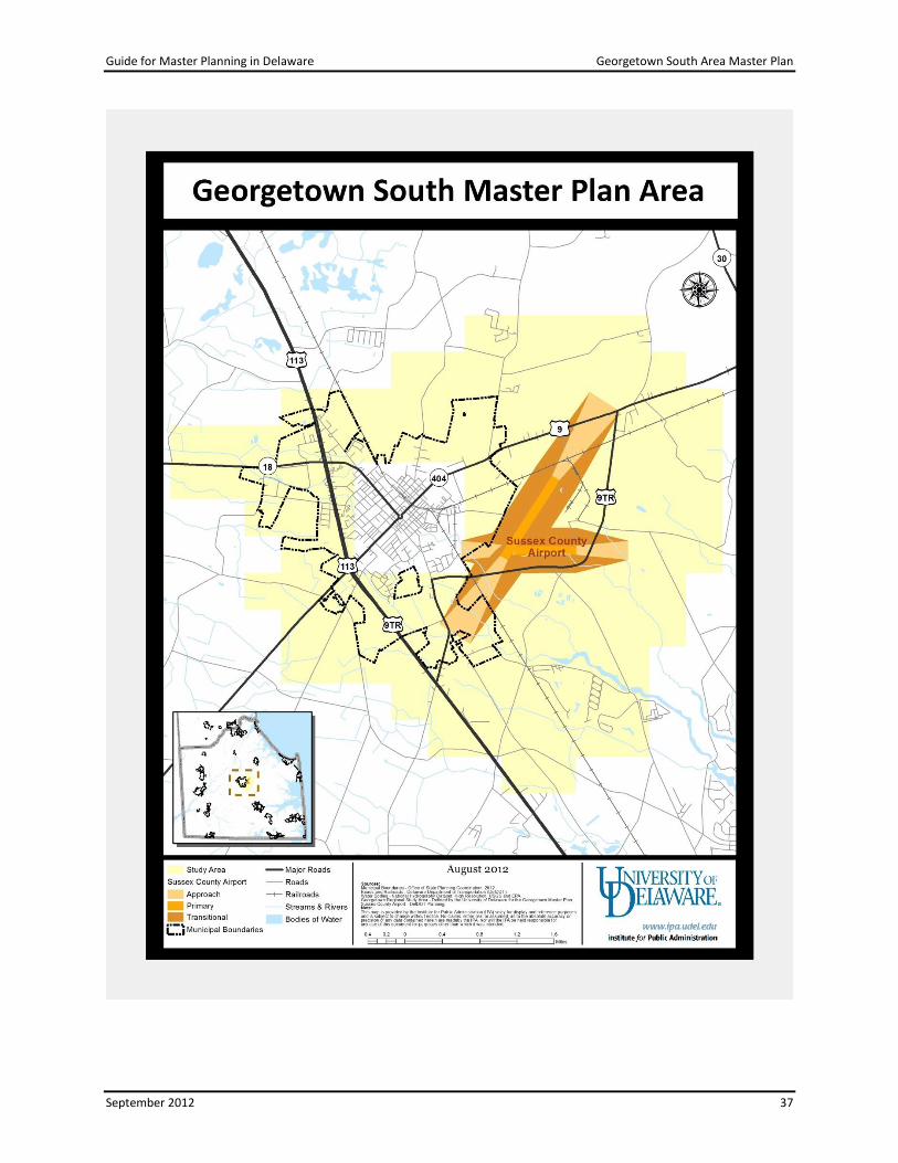
Getting Started
The Georgetown South Area Master Plan area is strategically located at the intersection of two
important transportation corridors (SR 404 and U.S. Rt. 113) and the Norfolk Southern Railroad
which operates an important freight-rail line. It is the county seat for Sussex County and,
accordingly, the center for a number of public and private job opportunities. The Sussex
County Airport, a regional aviation facility owned by Sussex County, is also in this area.
Adjacent to this airport is the 600-acre Sussex County Industrial Airpark,10 which has industrial
sites ranging in size from 2 to 6.5 acres.
Step 1. Identify Key Stakeholders
The initial stakeholders consisted of staff from OSPC, the Town of Georgetown, Sussex County,
and the University of Delaware’s Extension Office, which is located in Georgetown. Additional
members included staff from DelDOT and the airport, with IPA staff attending several meetings
mainly as observers. Staffs from DDA, DNREC, and Delaware Technical and Community College
were kept informed of the work and attended meetings as needed.
Step 2. Get Organized
The Georgetown South Area Master Plan was initiated following state review of the 2010 Town
of Georgetown Comprehensive Plan. During development and review of the town plan,
comments were made both by state and county interests that a regional approach was needed
to plan the future land use of the area surrounding the Sussex County Airport located adjacent
to, but outside of, the town boundaries. Some of this area was identified on the town’s
potential annexation area map in the plan, and concerns included balancing the proposed low-
density land use (about 3.5 units/acre) with land use appropriate for preserving and enhancing
the future of the Sussex County Airport and Sussex County Industrial Airpark as an economic
engine for Sussex County and the well-paying jobs associated with it.
Another reason for initiating this plan was to develop a process that would engage more of the
residents of this area into planning for future uses, in an effort to try to align their views with
the draft of the growth plans for this area. Opinions differ on the actual initiator of this plan,
but it is clear that OSPC staff assumed the lead role in assembling and coordinating this work.
The study area depicted on the previous page comprises about 11,000 acres. The boundaries
were selected based on the participants’ knowledge of the area, with the focus being on the
areas that will most likely impact state and local expenditures. Although some participants
expressed concern that the area might be too large, the study area remains unchanged.
10
For additional information, see www.sussexcountyde.gov/about/airport.

Guide for Master Planning in Delaware Georgetown South Area Master Plan
September 2012 39
Step 3. Commit to Move Forward
Considerable effort was made to develop an MOA for this work. A working draft was
developed, but it was not agreed to by the group and thus was not signed. Opinions differed
on the need for the MOA, with those in favor citing MOAs as beneficial for outlining
expectations for the planning work and formalizing an agreement that the participants will
work together until a result is realized. A key issue for the MOA was identifying the appropriate
representative to sign on behalf of the agency or jurisdiction.
Step 4. Assess Existing Conditions
OSPC staff and staff from the Sustainable Coastal Communities Initiative, based at the
Georgetown office of the University of Delaware, created maps and drafted written products.
Step 5. Involve the Public
Like the Milford Area Master Plan, CommunityViz® was utilized. The group used 100-acre grids,
to initially define the study area with CommunityViz®. As pointed out earlier, grids were
selected instead of parcel boundaries, natural features (such as streams), or man-made
features (such as roads) to take away some of the personal impacts of the work. The purpose
was to avoid situations in which a landowner is distracted from broad, regional, future uses by a
specific land use proposed for his/her property. At this time, the tiles are being smoothed into
more traditional boundary lines, such as parcel lines, roads, streams, etc.
The public participation process was refined for this project by lessons learned in, and the
process developed for, the Milford Southeast Neighborhood Master Plan. One refinement was
that planning concepts were explained to stakeholders at the beginning of the process. As a
result, the Georgetown process worked very well. It was noted that perhaps this public process
should be packaged as the format for future Master Planning projects. Another positive result
from this work was that the effort forced participants to think outside the boundaries of their
jurisdictions. Further, it is hoped that the relationships developed while working on this project
form the basis for consensus on, collaboration on, and support for the actions needed to
implement plan recommendations.
Step 6. Prepare Plan Draft
No written report has been prepared, but it is anticipated that it will be a document consisting
of the written plan and a set of maps. The sections will likely be written by various authors,
with OSPC coordinating the assembling of the final product.
Step 7. Get Feedback on Plan Draft
Since a plan draft is in-progress, no public workshops have been held.

Guide for Master Planning in Delaware Georgetown South Area Master Plan
September 2012 40
Step 8. Adopt Plan
The Georgetown South Area Master Plan is on-going; a final plan has not yet been adopted.
Step 9. Implement Plan
This is not applicable since the Georgetown South Area Master Plan is on-going.

Guide for Master Planning in Delaware Lessons Learned
September 2012 41
Lessons Learned
Elected officials must be involved in Master Plans. It is very helpful, almost essential, to
have a strong mayor or other local government leader to act as an advocate for the
project. In the Westown Master Plan, Middletown’s mayor advocated for the plan.
Besides elected officials, Master Plans need the support of top state and local officials.
Although no plan was produced, one of the things that “went right” with the Southern
New Castle County Infrastructure Master Plan process was the participation of the New
Castle County Executive and DelDOT secretary.
It is difficult for a state agency to be the lead. As recommended, a paid consultant is the
preferred alternative. Another approach is for OSPC to manage the project, as it can
engage all agencies.
All stakeholders should have a strong commitment to the project. To do this, articulate
the benefits of the project to each stakeholder to get buy-in. Property owners, local
government, and state agencies all benefit from knowing what type of development to
expect in a plan that spells out the phasing of investments in infrastructure and
services. If consultant services are to be utilized, buy-in can be enhanced with funding
contributions from key stakeholders.
A single large development project might be the catalyst for a Master Plan. Use the
prospect of such a project to engage all stakeholders in the Master Plan process, as was
done for the Westown and Eden Hill plans.
A strong consultant, one with skill in the issues being addressed, is deemed essential.
Having an outside consultant for the Southern New Castle Infrastructure Master Plan
was a key to managing the many stakeholders and pulling together a document covering
the very large planning area. For the Eden Hill Farm plan, DelDOT hired a consultant to
guide the process.
Don’t go it alone as an agency. The Churchman’s Crossing Master Plan project would
have gone much better if the Governor and Secretary of Transportation had engaged
the County Executive and Council from the start to explain the issue and get buy-in.
Develop a schedule with milestones for completing the plan and stick to it. This will help
stakeholders include time for the Master Plan in their own schedules. If something
takes longer than scheduled, revise the schedule.
Articulating the fiscal benefits and impacts of a Master Plan may be a way to engage
stakeholders and earn their commitments.

Guide for Master Planning in Delaware Appendix A. Memorandum of Agreement Example
September 2012 42
Appendix A. Memorandum of Agreement Example
MEMORANDUM OF AGREEMENT
BETWEEN
THE STATE OF DELAWARE
AND THE
CITY OF MILFORD, DELAWARE
FOR
THE COMPREHENSIVE MASTER PLANNING OF THE
“MILFORD EAST PLANNING AREA” AND ENVIRONS
THIS MEMORANDUM OF AGREEMENT (“MOA”) is hereby made by and
between the State of Delaware (“the State”) and the City of Milford (“the City”), a
municipal corporation of the State of Delaware and states as follows:
WHEREAS, the City has completed a comprehensive plan amendment that
would allow it to annex lands located East of Route 1, southwest of the current City
boundary, show on the map attached as “Exhibit A” and know hereinafter as “The
Planning Area;”
AND WHEREAS, the City initiated this plan amendment process due to
imminent development pressure in this area proposed under Sussex County regulations
which would have allowed housing to be constructed without public utilities or
municipal services;
AND WHEREAS, it is the City’s position that said proposed development
would have impacted the City in many ways, including but not limited to roads, police,
fire service, parks and libraries;
AND WHEREAS, the City desires to integrate this area into the municipal
limits in order to provide future developments with utilities and municipal services,
while also capturing tax revenue to offset the City’s cost in providing those services;
Page 1 of 5
Milford East Planning Area MOA

Guide for Master Planning in Delaware Appendix A. Memorandum of Agreement Example
September 2012 43
AND WHEREAS, prior to annexation the land in question was located in
Investment Level 4 according to the Strategies for State Policies and Spending, and the
development of this territory has the potential to negatively impact the State
transportation network, sensitive natural resources, and a viable agricultural area that the
State has already expended nearly $2 million to preserve;
AND WHEREAS, all parties agree that if development of this area is imminent it
should be planned and implemented in a fashion that protects critical natural resources,
ensures the continued viability of the agricultural economy, maximizes needed
infrastructure investments, provides sufficient tax revenue to support city services, and
integrates into the transportation network to ensure safe and convenient travel for all
current and future residents of Milford;
AND WHEREAS, after plan certification and annexation The Planning Area is
considered to be in compliance with the Strategies for State Policies and Spending and
the City of Milford has the legal right and obligation to manage the development of any
lands within its boundaries through zoning and other land use regulations;
NOW, THEREFORE, BE IT RESOLVED that the State and the City,
intending to be legally bound, do hereby agree:
1) To work cooperatively through the planning process to produce a comprehensive
regional master plan to include land use policies and the transportation, sewer,
water, and other community facilities plans needed in order to best accommodate
future growth and land preservation in the Milford East Planning Area and
Environs (The Planning Area). The scope of work for this master plan is attached
as “Exhibit B” and is hereby made a part of this agreement.
2) To actively involve other key stakeholders in the preparation of the master plan
for the Planning Area. The master plan is to be coordinated with these
stakeholders to the maximum extent that is possible, depending upon their interest
Page 2 of 5
Milford East Planning Area MOA

Guide for Master Planning in Delaware Appendix A. Memorandum of Agreement Example
September 2012 44
and ability to be actively involved in the planning process. Key stakeholders
include, but are not limited to, Sussex County, Kent County, the Town of
Slaughter Beach, the Milford School District, emergency service providers
such as the Carlisle Fire Company and Sussex EMS, and any relevant State
agencies.
3) To work cooperatively and coordinate these planning efforts to ensure that
property owners, residents, business owners, developers of proposed
developments in the project area, other interested parties, and the general public
have an opportunity to participate in the plan.
4) That it is the intent of the parties to ensure that sewer, water or public utility
infrastructure is not extended into areas outside designated area to serve new
development, unless the City, State, and County agree and such extensions are
part of a future certified comprehensive plan. The parties agree to use all
technical, administrative, and legal means available to ensure that this is achieved.
The parties reserve the right to consider health, safety and welfare issues related
to existing uses, such as remediation of failing septic systems, on a case-by-case
basis.
5) To work collaboratively to determine the needed transportation improvements to
serve the intended uses and densities in the Planning Area, and to integrate those
needs in the master plan document as a detailed circulation element. The State,
the City, private developers and land owners will work jointly to develop cost
estimates, funding strategies, implementation plans and land use controls to
ensure that new development activity is implemented in conjunction with needed
transportation improvements.
6) That it is a goal of the parties to ensure the continuation of the agricultural
economy and the many viable agricultural land uses in the environs around the
Planning Area, and to include strategies and implementation mechanisms in the
master plan that foster the preservation of these areas.
Page 3 of 5
Milford East Planning Area MOA

Guide for Master Planning in Delaware Appendix A. Memorandum of Agreement Example
September 2012 45
7) That it is the goal of the parties to recognize and protect the important natural
resources in the Planning Area, and to include strategies and implementation
mechanisms in the master plan that foster the preservation of these areas.
8) That in order to support the necessary public investment in infrastructure and
services, the gross residential density in the Planning Area will be no less than
four (4) units per acre and no more than eight (8) units per acre.
9) To consider and encourage a variety of appropriate and complimentary land uses
in The Planning Area, including hospitals, schools, other institutional uses, small
scale commercial uses intended to serve the local area, and parks.
10) To institutionalize a process for continual communication and monitoring of plan
implementation that includes regular information sharing, developing a set of
indicators for the timing of new infrastructure investment, and acting on such
indicators in order to provide the infrastructure when needed.
11) That the City may consider the annexation of properties in the Planning Area at
any time after plan certification.
12) That the none of the parties will give any subdivision, site plan, development
approvals, or permits for new development activities prior to the completion of
the master plan, and then only in compliance with the master plan.
13) That the City of Milford waives its legal right to further amend its Comprehensive
Plan until February 25, 2008 when the City will be required to review its
Comprehensive Plan under 22 Del. C. § 702.
14) To review the provisions outlined within this Memorandum of Agreement
annually beginning one year from the date affixed by the signatures below.
Page 4 of 5
Milford East Planning Area MOA

Guide for Master Planning in Delaware Appendix A. Memorandum of Agreement Example
September 2012 46
Page 4 of 5
Milford East Planning Area MOA
Signature Page

Guide for Master Planning in Delaware Appendix A. Memorandum of Agreement Example
September 2012 47

Guide for Master Planning in Delaware Appendix B. Community Engagement Tips
September 2012 48
Appendix B. Public-Engagement Tips
Give sufficient notice so that participants can fit meetings and workshops into personal
and work schedules.
Enlist stakeholder representatives in the notification process. Ask local civic and
business groups to announce workshop dates. Use local listservs, municipal utility bills,
and community newsletters.
Hold workshops and public meetings at convenient locations with sufficient parking.
Consider holding meetings when no other significant community events are scheduled.
Consider placing notices in other than the legal notice sections of newspapers.
Ask the local newspaper to do an article on the Master Plan as a way of generating
community interest.
Make sure that the meeting room is comfortable and large enough to accommodate
expected number of participants.
Ensure that the location for public meetings is ADA-compliant and can accommodate
persons with special needs.
Provide refreshments.
Provide childcare.
Use a skilled facilitator whose primary interest is to create a successful public-
participation effort.
Make sure participants know why they are there. Equally important is to tell people
what will not be dealt with in the meeting. For example, inform participants that they
are not attending a rezoning hearing.
Consider using small discussion groups to work on separate topics or to analyze how
various groups react to the same issue.
Discussion groups should be diverse. Mix developers, residents, and government
officials. Try not to let friends sit with friends.
Set time limits for discussion of individual topics; try not to revisit prior issues during
discussion of subsequent items.
Provide many mechanisms for input. Some people are not comfortable speaking in a
group setting and may prefer writing their thoughts on paper or talking one-on-one with
a facilitator.

Guide for Master Planning in Delaware Appendix B. Community Engagement Tips
September 2012 49
Establish a website for the project where interested parties can post comments, ask
questions, or request information; assign someone to monitor questions and inquiries
as well as to summarize comments. This could be an in-kind contribution from one of
the stakeholders identified in Step 2.
Use social media, such as Facebook and Twitter. New Castle County used Twitter to
receive comments on its 2011 Comprehensive Plan Update.
Use visual aids, such as CommunityViz® to help participants picture alternative
development scenarios.
If funds and expertise permit, consider using electronic polling to tally preferences.
Allow sufficient time for public comment following public meetings.

Guide for Master Planning in Delaware Appendix C. Stakeholder Commitments Example
September 2012 50
Appendix C. Stakeholder Commitments Example
Below are selected stakeholder commitments reproduced from Chapter 11 of the Milford
Southeast Neighborhood Master Plan. These commitment statements illustrate the level of
detail that Master Plans should incorporate.11
The City of Milford 1. The City will develop and adopt an ordinance to enable to use of transfer‐of‐
development rights (TDRs) credits in receiving zones. This ordinance will enable developers build at up to eight (8) units per acre by‐right through the purchase of TDR credits from farms in the sending areas.
2. A stormwater utility is a legal and financial structure to allow stormwater management facilities to be constructed, managed, and maintained in common by a local government or other entity. This Master Plan area is well suited to such a utility, although there are many ways to structure such an entity. Both the City and DNREC agree to explore this option in more detail as this area develops in accordance with this Master Plan.
3. The City will construct a public water system as described in Chapter 9 to serve the Master Plan Area. This is a funded project.
4. The City will design and permit a sewer system to serve the Master Plan Area as described in Chapter 9. Private developers will be responsible for funding and constructing this system. The City will discuss various financing and construction options with any developer.
Delaware Department of Agriculture 1. The Delaware Department of Agriculture (DDA) and the Delaware Agricultural Lands
Preservation Foundation (DALPF) will partner with the City to establish a Transfer of Development Rights program as described in the Agricultural Preservation chapter of this document (Chapter 4).
2. By partnering with DALPF, the City will avoid the initial financial expenditures required to preserve a parcel of land. These expenditures include paying to survey the property, paying the legal costs of a real estate settlement, and other associated administrative costs. DALPF would bear those costs.
3. The City would avoid the future obligation of monitoring the preserved farms to make sure they remain in compliance with the preservation agreement (easement). DALPF would assume that responsibility and add any properties preserved by Milford to the hundreds of permanently preserved farms it already monitors. In addition, should any
11
For additional information on this plan, see www.cityofmilford.com/index.aspx?NID=82. especially pages 71-75 of the SE Master Plan.

Guide for Master Planning in Delaware Appendix C. Stakeholder Commitments Example
September 2012 51
future litigation be required to uphold the preservation easement, the City would not have to incur any legal costs.
4. DDA will assist the City in the creation and administration of a TDR bank as described in the Agricultural Preservation chapter of this document (Chapter 4). This includes assistance with appraisals to set the fair market value of TDR units.
5. In addition to any funds the City would have for agricultural preservation and the TDR bank, they would also be eligible for state matching funds from DALPF, as well as any federal matching funds from United States Department of Agriculture (USDA) Farm and Ranch Lands Protection Program (FRPP). As allowed by law, these matching funds would be awarded to the city based on availability. If the City were able to capture state and federal matching funds, it could significantly leverage its funds with additional money and preserve additional farmland.
Delaware Department of Transportation (DelDOT) 1. DelDOT will fund and construct the grade separated interchange at SR 1 and SR 30 as
per the current Capital Transportation Plan (CTP). The current timeline involves construction in 2012 and 2013, with completion in late 2013. Please note that the CTP is subject to amendment annually.
2. Work with the City of Milford to adopt this Master Plan area as a Transportation Improvement District (TID) to enable equitable and timely funding for roadway improvements within the area in accordance with the recommendations in this Master Plan.
3. DelDOT will work with the City to ensure that the road improvements identified in this report are implemented by the public and/or private sector in a phased manner that is paced with the timing of development activities.

Delaware Office of State Planning Coordination
122 William Penn Street Third Floor Dover, DE 19901
phone: 302-739-3090 fax: 302- 739-5661
stateplanning.delaware.gov
The Office of State Planning Coordination (OSPC) reports to the Governor's Office and works
closely with the Cabinet Committee on State Planning Issues. The Office of State Planning
Coordination's mission is the continuous improvement of the coordination and effectiveness of
land use decisions made by state, county, and municipal governments while building and
maintaining a high quality of life in the State of Delaware.
The Office meets its mission through:
Effective coordination of state, county and local planning efforts;
Coordinating state agency review of major land use change proposals prior to
submission to local governments;
Research, analysis, and dissemination of information concerning land use planning;
and
Aiding the effort of the state to meet the information needs of state agencies and local
governments, especially in the realm of spatial data and Geographic Information
Systems (GIS).
Institute for Public Administration School of Public Policy & Administration
College of Arts & Sciences University of Delaware
180 Graham Hall University of Delaware Newark, DE 19716-7380
phone: 302-831-8971 e-mail: [email protected] fax: 302-831-3488
www.ipa.udel.edu
The University of Delaware’s Institute for Public Administration (IPA) addresses the policy,
planning, and management needs of its partners through the integration of applied research,
professional development, and the education of tomorrow’s leaders.
The University of Delaware is a non-discriminatory, equal opportunity, and affirmative action institution. See www.udel.edu/aboutus/legalnotices.htmlfor detailed policy information.