guide to the college valley - northumberland
DESCRIPTION
Guide to 12,000 acres of wilderness in the Cheviot hills. Covers history, nature and estate management.TRANSCRIPT

The College Valley
This guide is written principally for guests to the Valley. People who are staying at one of the four holiday cottages. However it might also be of interest to anyone else who wishes to explore this beautiful part of Northumberland.
Directions
The first important point to realise is that there are no signposts for the College Valley. The closest you get is a signpost for Hethpool which is on the B6351 at Westnewton.
The easiest way to get to the Valley starting at Wooler is to take the A697 north, signposted for Coldstream and Scotland. At Akeld, where the A697 takes a right hand turn you will come to what the locals call “The Flags”. These fly outside the Akeld Manor and Country Club. It is here that you turn left onto the B6351. Continue along this road past Yeavering and Kirknewton. You will shortly cross a bridge over the College burn which flows out of the College Valley. Immediately after this you come to the small hamlet of Westnewton. Turn left following the sign for Hethpool, 2 miles. After this turn there is no through road, just 16 kms to explore the College Valley.
Follow this single track as it climbs upwards until you reach the point where the College Valley opens up before you. Stop here and take a minute to enjoy the view.
If you have a sat nav then enter postcode NE71 6TW to get to Hethpool.

Entering the Valley.
As you pause at the top of the hill leading into the Valley stop and admire the view laid out below. What you are seeing is a valley closed off from the outside world. There are no signposts to invite curious travellers. The roads all end within the valley so no one comes here on their way to somewhere else. The picture below shows the long view towards Red Cribbs and the Schil in the background. The white house in the middle is “Whitehall”. Hethpool is bottom left and there is a second valley to Trowupburn and Elsdonburn to the right of the picture.

If you turn around and look back the way you have just come then this is what you see. The road to enter the valley follows the line of trees on the right and the viewpoint is within “Trafalgar woods”.
On your left of the picture above is White Hill. At 226m there is easy access to the top and tremendous views up the Valley. At the start of the track to the top is Trafalgar Wood. A small monument tells you that the trees here were planted in 2005, to celebrate the 200th anniversary of the battle of Trafalgar. The Valley’s historical link comes from Admiral Collingwood who owned substantial parts of the Valley and indeed, planted acorns on the hill to your left. His plan was to grow oaks which in turn could provide wood for the Navy. Interestingly Sir Arthur Munro Sutherland who owned the valley from just after the 1st world war until he died in 1953 mentions the oaks being planted by Collingwood’s wife.
The hill with the oaks ( right in the picture ) is called Hethpool Bell. Unfortunately there is no easy access to it from the Valley.
As you drive down the hill the road forks and you need to take the left hand branch. At this point you are entering the private road system. Follow the road under the avenue of trees and you come to Hethpool house on your left. The house is open for B&B.

Hethpool.
Hethpool is an ancient village with a history going back to border reiving times and before. If you walk down the lane towards Hethpool house then look out for the pair of Cannons hidden in the shrubs on your right. They came from Newcastle in the 19th century. There is also a nice summer house on your left and as you follow the lane further you will come to a gate to access Hethpool Lake.
This picture shows the view across the valley towards the “arts and crafts” cottages at Hethpool. It is taken from along St Cuthberts Way. The path would have crossed the bridge below Hethpool Mill and started to climb up the hill towards the plantation.
As you drive past the turning for Hethpool house the road takes a very sharp right hand turn. The terrace of houses on your right was built in the 1920’s in the arts and crafts style ( see picture above). Immediately after turning right there is a track and cattle grid on your left. This follows St Cuthbert’s Way across the Valley, up onto Newton Tors and eventually on to Wooler and Holy island. The track is also the access point for the self catering holiday cottage at Hethpool Mill.
Just past the terrace of cottages you cross a cattle grid and immediately on your left is the public car park. Access beyond this point is limited to permit holders or guests at the holiday cottages only.

This autumnal picture was taken looking down the small side road to Hethpool house and the lake.
The road to Southernknowe.
After the car park the flat ground on your right is the site for a Neolithic stone circle. There are a few low lying stones left to give an indication of how large this circle must have been. This field is also the site for the College Valley summer fete which is usually on the first Saturday in August.
The first hill on your right after the field is Great Hetha with its hill fort on the top. Looking to your left over the valley the broadleaves you see growing on the lower slopes are the Harrowbog. This is the largest remaining semi natural woodland in the Northumberland National Park and also the site for an old abandoned farmhouse. Now there are just two farms covering the whole 12,000 acres. But originally there were many more small farms with shepherds. Without quadbikes this was a large area to cover.
After a short distance the conifer woods come down to the road on your right. This is now Sinkside Hill and soon you will come to the large house at Whitehall. At this point look for a wide forest track opening on your right. This goes to Trowupburn, Elsdonburn and the western hills of the College Valley. It is a key part of many circular walks.
Shortly after this on your right hand side is Grey’s cottage. It’s a small wooden cottage in the middle of a field. Quite unique and local folklore attributes its origin as having been built for a Lady of the Grey family who suffered from tuberculosis. She was advised to go to Switzerland for the benefits of fresh air. She chose the Valley instead and lived many more years.
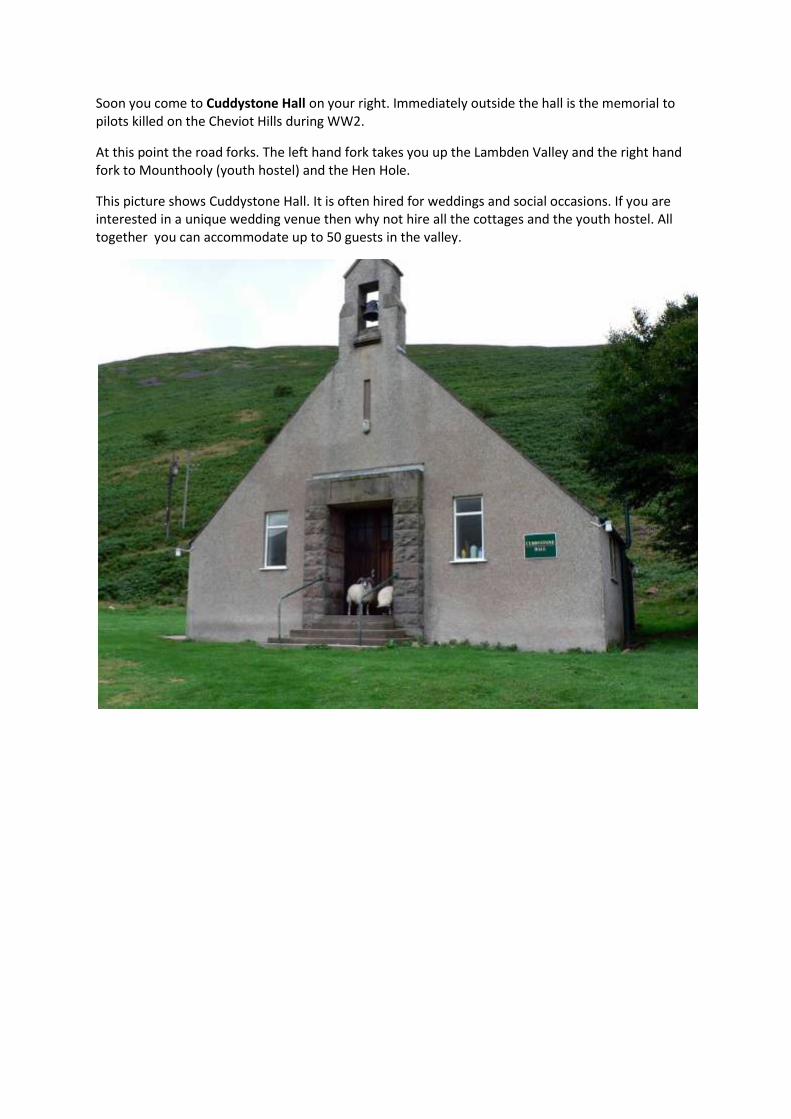
Soon you come to Cuddystone Hall on your right. Immediately outside the hall is the memorial to pilots killed on the Cheviot Hills during WW2.
At this point the road forks. The left hand fork takes you up the Lambden Valley and the right hand fork to Mounthooly (youth hostel) and the Hen Hole.
This picture shows Cuddystone Hall. It is often hired for weddings and social occasions. If you are interested in a unique wedding venue then why not hire all the cottages and the youth hostel. All together you can accommodate up to 50 guests in the valley.
Cuddystone to the Lambden Valley
When you take the left hand fork at Cuddystone you will shortly cross the river at Sutherland Bridge. This is a good stop to picnic besides the river. Immediately after crossing the bridge there is a small bank on your left which is covered in primroses in April.
On your right are two houses. Southernknowe and The Old School house. The latter is one of the 4 holiday cottages in the Valley.
Climbing along the single track road you will soon pass Coldburn cottage on your right. The road then passes under Dunsdale crags and comes to a bridge or ford back over the Lambden burn. There is then a short steep climb and you enter the Lambden Valley proper. On your right, further up the hill is Dunsdale house. This is an important point for walkers who are covering the circular route from Langleeford to the Cheviot and back. At this point they follow the path up to Dunsdale and then take a small climb along the side of the hill and down to Mounthooly before walking through the wilderness and up onto the ridge beside the mountain rescue hut.
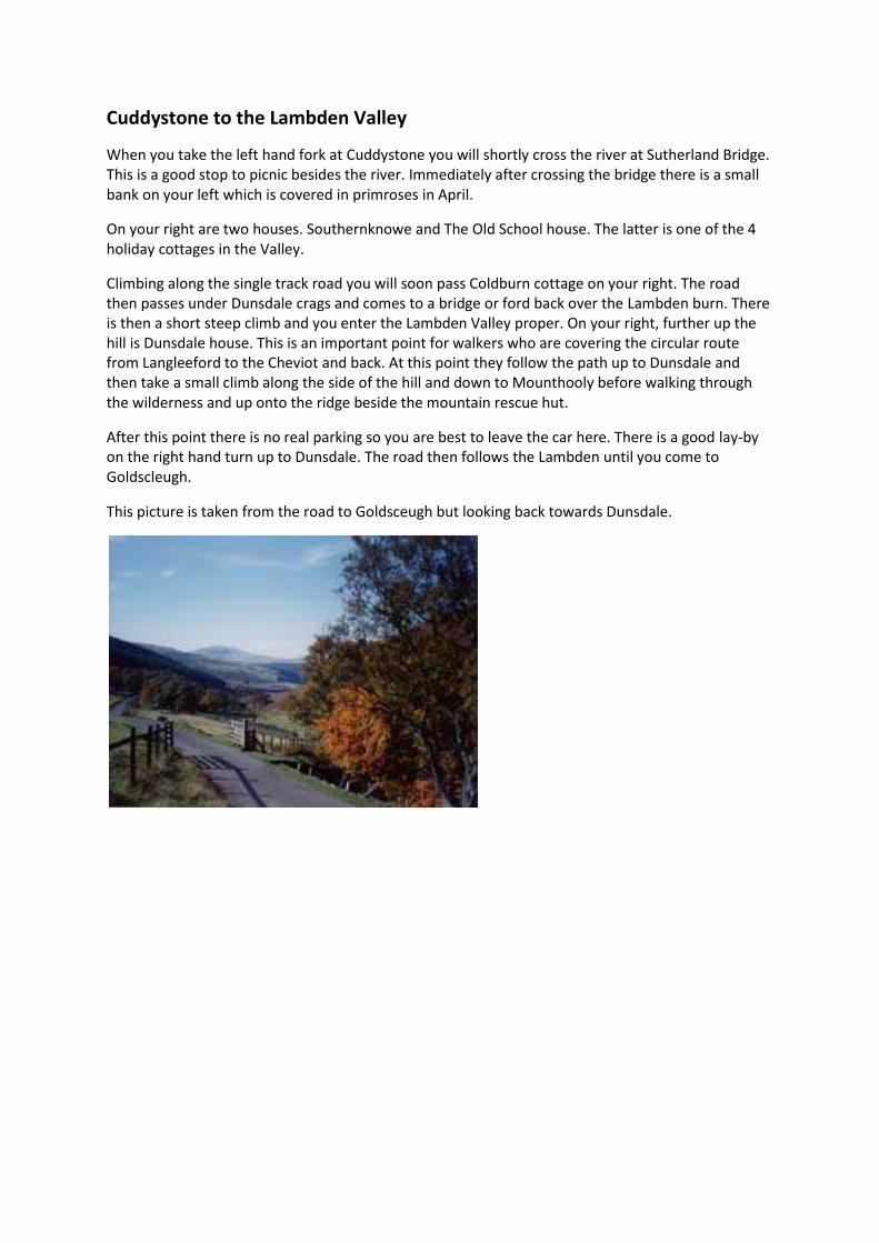
After this point there is no real parking so you are best to leave the car here. There is a good lay-by on the right hand turn up to Dunsdale. The road then follows the Lambden until you come to Goldscleugh.
This picture is taken from the road to Goldsceugh but looking back towards Dunsdale.

Cuddystone to Mounthooly
If you follow the right hand road at Cuddystone you will come to the youth hostel at Mounthooly. But before this you will pass the house at Fleehope. When you arrive at Mounthooly there is ample parking on the right hand side before you enter the YHA grounds.
This is the start of the circular walk up the Schil ( on your right) and then follow the Pennine way towards Auchope cairn and the Cheviot. Stop at Red Cribs to admire the view down the valley. Just after the mountain rescue hut turn left down the hillside. On your right you will have fantastic views into the Hen hole.
The Youth hostel at Mounthooly

Trowupburn and Elsdonburn.
When you first enter the Valley and drop down the hill towards Hethpool the road forks. If you take the right hand turn you are on the road for Trowupburn and Elsdonburn. Although this is a public road there is precious little parking space and it is a no through road so you are best to explore this valley on foot. Look for the cultivation terraces on your right.
Walking in the Valley
Great Hetha. The public car park is the best starting point. Walk up the Valley and as soon as you pass the small plantation on your right start to follow the track up the hill alongside the wood. At the top of the wood turn left and head for the top where there is an Iron Age fort. You will have fantastic views across the Valley. From the top there is a gentle descent towards Trowupburn where you can then follow the road back to Hethpool.
This picture shows the view from Great Hetha north towards the Millfield plain. You can just make out the cottage at Hethpool Mill towards the bottom right. Hethpool lake is centre left and behind it you can see the Collingwood oaks on Hethpool Bell. The field immediately at the bottom of the slope is where the stone circle is and you can just make out the public car park beside the field. This photo was taken about 10.00 am as the sun was rising in the east and starting to shine into the valley.

Whitehill. This is the first hill on the right as you enter the Valley. The best place to park is right at the bottom of the hill, over the cattle grid, and on your right. Here you can climb past the cultivation terraces and quickly gain some height. From here you can walk along the ridge gradually climbing until you come to Haddon Hill. From here the path runs through the top of the Elsdonburn plantation and then drops down onto Ring Chesters and Crowden Sike. Look at the cultivation terraces at the bottom of the hill.
Trowupburn. The western hills of the College Valley are quiet and rarely walked. They offer beautiful views into Scotland without any arduous walking. One favourite way to access the Valley is by taking the forest track from the valley road at Whitehall. This takes you down to Trowupburn where you have a choice. You can proceed along the road back. This takes you along the bottom of Great Hetha and from here down to Elsdonburn and back to Hethpool. Alternatively instead of following the road you can follow the stream further up the valley. This takes you up to the border line with evocative names like Maddie’s Well, Tuppie’s Grave, Eccles Cairn and Tom’s Knowe. The path at Trowupburn takes you through part of the farm yard and can be quite muddy!

Hethpool Linn. The waterfall at Hethpool Linn is a beautiful quiet part of the Valley. There are two ways to get to it.
On the way to Hethpool Mill the bridge crosses over the College Burn. Immediately before you cross the burn there is a gate to the left which takes you through a small field, below Hethpool lake and you will approach the Linn from the west bank.
The second way is to cross the bridge towards Hethpool Mill but immediately you cross the bridge follow the track to the left. You are on St Cuthbert’s Way and it leads through a small plantation. When you leave the woods, you also leave the College Valley estate lands and follow the track until a stile takes you over a stile and into a small glen. Take the path to the left and follow it downstream until the small stream joins the College burn at Hethpool Linn.

Hethpool Lake. Accessed from avenue alongside Hethpool house. This is a manmade lake with some interesting history. It was used to power a generator to bring electricity to the Village. There is also a disused Salmon run at the end of the Lake. There is no formal access to the shore and care is needed. Please note that there is no formal right of way past Hethpool house and through the courtyard. However guests staying in the cottages are welcome to visit the lake. The pathway around the lake is not maintained and can be dangerous especially for little children, please take care.

Newton Tors. These are the hills along the east side of the Valley. There is a great circular walk as follows. Start at the car park just below Great Hetha. Walk back towards Hethpool but cross the cattle grid on your right marked for Hethpool Mill. Follow the track until it crosses the College burn. At this point take the track to your left. You are now following St Cuthbert’s Way. The path takes you through the middle of a pine forest. At the other end you leave the College Valley itself and cross swampy ground heading for a small glen running down the hill. Climb over the stile and follow the path to the right (to the left takes you down to Hethpool Linn). You then continue climbing until you come to a remote house ahead and to the left. At this point the path heads to the right and there is a steep climb up onto the Tors themselves. Up there you can see the grouse buts and where the heather has been burnt. Easter Tor, Wester Tor and eventually Harelaw are all short climbs from the path and eventually you will descend to Southernknowe from which point it is a simple walk back along the road.
Please note that whilst it is possible to walk across the Goldsceugh the way can be very boggy in wet weather and care is needed descending through the plantation above Goldsceugh as the public right of way is heavily obscured by falling trees.
This picture was taken just past the Harelaw and is looking towards the Cheviot.

The Schil and Hen hole. A relatively easy walk from the car park outside Mounthooly up to the border fence and then follow the Pennine Way (in reverse) until you reach Red Cribs with its fantastic views down the whole length of the Valley. Shortly after at the mountain rescue hut turn left and descend down into the Valley. The Hen hole is open on your right.
This picture is taken from Red Cribbs looking down the length of the valley.
Cheviot itself. Access either from the Schil and Auchope Cairn, Goldscleugh or directly up from Braydon Crags. Take care on the top. You should use the track running along the Border fence (it is the Pennine Way) to reach the summit. Away from the track the peat bog is dangerous.

Braydon crags
A short 45 minute to one hour walk from Dunsdale. The last part is quite a pull as there is no proper path and you have to walk over and around the grass tussocks.

Archaeology and history in the Valley
The Valley is full of reminders from the past.
Start with the Neolithic stone circle just past Hethpool. Especially worth visiting in the quiet evening light.
The Iron Age hill forts are the next most recent remains. Great Hetha and Ring Chesters are easily accessible and both provide great views.
There are Romano/British remains within the Valley. The best site to see this is after you have walked past the YHA at Mounthooly. You come to a brief conifer forest on your right and immediately after this stop and look up the hill. All you see now are the ridges and lumps in the ground that was once a dwelling.
The Valley has many cultivation terraces from the middle ages. The easiest ones to see are at the bottom of Whitehill. On entering the Valley park at the point where the road splits for Trowupburn and Hethpool. On your right you can see the terraces.
For more recent history visit the WW2 memorial at Cuddystone and then climb up to Braydon Crags to hunt for the remains of the Flying fortress amongst the peat hags.
This picture shows some of the wreckage just below Braydon Crags

Farming in the Valley
There are two tenant farmers. Bill who lives adjacent to Hethpool house has the sheep around Hethpool. Ted, who lives at Elsdonburn, covers the rest of the College Valley.
Sheep are the main animals but occasionally there are some cattle within the Valley.
This shows the sheep being brought down. It was taken in February 2009 just above Dunsdale as the weather turned cold and snow blanketed the Cheviots.
Wildlife in the Valley
The feral goats of the College valley are quite famous. They have a white/blue coat as opposed to the piebald markings more commonly seen on feral goats. The Valley people work with the National park staff to monitor and check the goats. You are most likely to see them either on the Newton tors or close to St Cuthberts way just past the plantation between Hethpool Mill and Hethpool Linn.
Birds. You will see bird spotters regularly. Owls, heron and ravens are relatively common.
Animals. Deer are common. There are also fox, red squirrel, stoats and so on. Otter have been spotted in the Valley but it is more usual to find evidence of their presence.

Activities in the Valley.
Horse riding. The Valley has over 100kms of roads and paths with some great horse riding. If you want to keep your horse overnight then usually arrangements can be made.
Cycling. With so many pathways the options for mountain biking are tremendous.
Fishing. It is possible at Hethpool Lake by arrangement with the estate agents.
Shooting. Again by arrangement with the estate agents.
Seasons in the Valley.
The Valley is famous for its displays of gorse during April and May when the smell of vanilla permeates the air. During the summer the Valley is lush and verdant. The river becomes slow and sluggish and you can walk across it or build dams with the Children. In autumn the broadleaves change and the colours are beautiful. Come winter with the snows the Valley quietens down.

Things to do outside the Valley
Activities.
Border Gliding at Millfield. Using the old WW2 airfield the gliding club offers a 20 minute flight for £60. The glider will be taken up to above the Ad Gefrin plain and it will usually circle around the Lanton monument. From here you will have views up the College Valley as well as across the Glendale plain.
Fishing. There are fisheries where you can purchase a day permit. For river fishing please ask Sale and partners for advice. There is also good sea fishing available off the side of boats.
Rock climbing and bouldering. Within the valley you have Bizzle crags. But, arguably, the best climbing is at Bowden doors just outside Belford.
Beaches. The beach at Bamburgh is just 14 miles from Wooler. Goswick sands to the north of Holy Island are usually very quiet. Another firm favourite is Alnmouth which also has the attraction of good pubs within the port.
History.
Flodden. Look for the village of Branxton. There is a monument close to the village but equally importantly you can hunt out the story boards which are laid around the battlefield explain what happened.
Northumberland rock art. The county is famous for the cup and ring marks engraved into local stones. The best place to see these is up around Doddington golf course. Take the Berwick road out of Wooler and park on the road beside the entrance to the golf course. You will need one of Stan Beckensall’s books to help find the locations.
Old churches. Eglingham church along the one at Old Bewick are both remarkable and well worth a visit.
Castles. You are spoilt for choice. Norham and Chillingham are both close. A little further away are Bamburgh, Alnwick and the atmospheric Dunstanburgh Castle.
Shopping. Wooler should provide most of your provisions but there are larger shops in Alnwick or Berwick.
Doctor or vet. There is a large medical centre in Wooler. A little further up the main road and with good parking. The vet is on a side road close to the Tankerville arms.

Questions and answers.
Best walk if wet or just want a gentle stroll. Follow the valley up to Whitehall and then look for the forest track to Trowupburn. From their either return via Great Hetha or follow the Elsdonburn road back to Hethpool.
Easiest climb for great views. Park just before Mounthooly and walk up the Schil. Follow the border ridge towards the Cheviot until you reach Red Cribs. Then at the mountain rescue hut follow the track back down into the valley and return to your car. The walks to Braydon Crags (from Dunsdale ) and Great Hetha also offer good views for only a short climb.
Good mid level walk. The Easter Tors round between Southernknowe and Hethpool.
Quietest part of the Valley. The western hills and Ring Chesters.
Easy mistakes when out walking.
Trying to reach Red Cribbs and the Schil from Braydon Crags. The Henhole is in the way and although it is probably feasible and safe to descend into the valley above Mounthooly there is no easy walking here.
Trying to climb from Hethpool Mill directly up onto the Tors. Possible but a real struggle.
Trying to trace the low level path along the eastern side of the valley between Hethpool Mill and Southernknowe. Wait until it is fully signposted ( written autumn 2010).
Forgetting just how deep the peat bog is around the summit of the Cheviot. Keep to the boardwalks.
It’s raining! Head for the coast. The climate is separate to that around the Cheviot and will often be better.

The houses in the Valley
Dunsdale.
Right at the start look at the view in the picture below. This is what you see from the dining room. You are looking right up towards the Bizzle crags.
Dunsdale is a large house which has been created by converting the old byre into an separate annexe. This means that the 4 bedrooms are really two upstairs in the old portion and two downstairs in the annexe. This provides great privacy if you have a group of people or alternatively just want the children upstairs and safely out of the way.Dunsdale is possibly the highest house in Northumberland and you are ideally situated for easy walking straight out of the door.
There are good dog kennels outside.

Coldburn cottage.
Coldburn is found as you start to climb towards the Lambden valley from Southernknowe. It is the next house down from Dunsdale. An old fashioned two up two down it is cozy, quiet and has a lovely enclosed garden. There is a small stream or burn right outside it.
This picture shows the large enclosed garden.
There are steep stairs to reach the two upstairs bedrooms. The kitchen is large and well equipped . This is a warm and cosy cottage.
In the early morning or at evening time it is very pleasant to walk along the road as it climbs towards the Lambden valley. It was here that an iron age arrowhead was found and you can sit beside the stream as it flows down towards Southernknowe.

And this shows the view up the valley towards the Cheviot.

Hethpool Mill.
The Mill is the first of the holiday cottages as you come into the valley. The conversion was unusual in that most rental properties are redesigned to provide as many bedrooms as possible. The Mill has just two within a large open plan design. This picture was taken from the bank behind the Mill and is looking towards Hethpool .
The Mill is a very warm, clean and modern house. It is easy to relax here.

Pictures in the College Valley
The Valley is a great place for photographers. With the light constantly changing, the long views across the hills and the history and wildlife there is always plenty of choice.
This picture was taken looking down the valley from above Mounthooly. The light and colours are typical.

This dramatic picture was taken during the burning of the heather. You will see the large squares which are burnt every year to provide better breeding and living conditions for the grouse.
Looking into Scotland. The Valley is the only place in England where you can look for miles south into Scotland.


References for further reading
The main valley website.
Northumberland National park
There is plenty of interesting information here. Let us quote directly from the site
“The College Valley is one of the gems of the Northumberland National Park”.
For serious access to historical sites – keys to the past.
Photographs of the Valley.
Northumbria-byways to book a cottage in the valley
The Byways blog with lots of articles about the Valley
Northumberland tales has a lot of information on the valley.
Books about the Valley include Walking the Cheviots Classic Circular Routes. Ed Baker The Cheviot Hills as well as Walks from Wooler. Both by Geoff Holland Where the Hills meet the Sky: A guide to wartime aircrashes in the Cheviot Hills.Peter Clark. Published by Glen Graphics Rural branch lines of Northumberland C.R.Warn. Published by Frank Graham Northumberland Prehistoric Rock Carvings Stan Beckensall. Pendulum publications Northumberland, The Official National Park Guide Tony Hopkins