guidance on developing structural operating protocols
TRANSCRIPT
Guidance on DevelopingStructural Operating Protocols
March 2009
Website Version

2
3
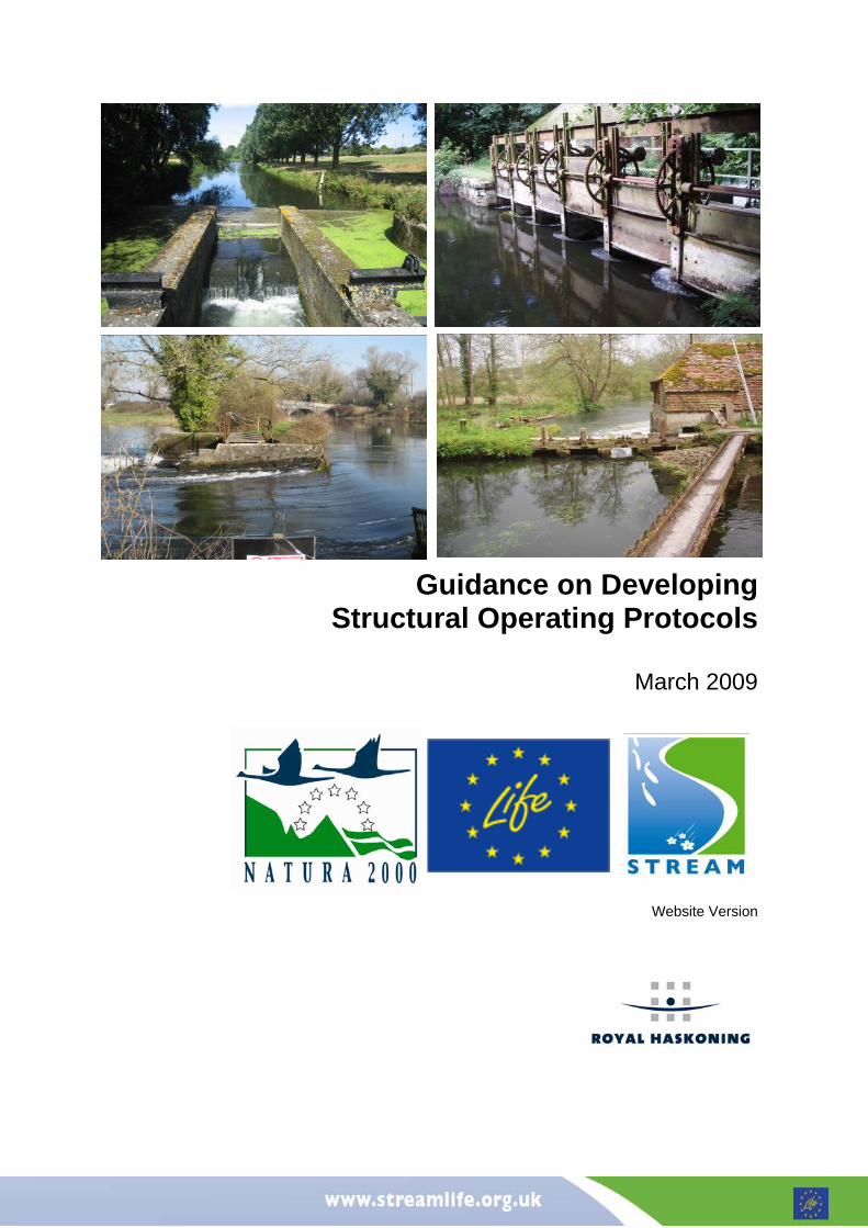
The River Avon, upon which this approach is based, is one of the UK’s most biodiverse chalk streams. The importance of the river is recognised by its designation as an internationally important Special Area of Conservation (SAC) and Special Protection Area (SPA), as well as a Site of Special Scientific Interest (SSSI). Sluice and hatch operation is a key factor in managing water levels throughout the River Avon catchment. With over 100 weir and hatch structures throughout its entire length, it is crucial that an integrated approach to their management is adopted to enable control of water levels for the benefit of the river and adjacent floodplain and to reflect the many different functions of the river. Currently, many of structures along the River Avon are in private ownership and hatch operators have no clear guidance on best practice. Demonstrating Strategic Restoration and Management (STREAM) is funded jointly by the European Commission's LIFE-Nature programme, Natural England, Environment Agency, Wiltshire Wildlife Trust, Hampshire and Isle of Wight Wildlife Trust, and Wessex Water to improve river habitat conditions along a number of reaches of the River Avon Special Area of Conservation. As part of the STREAM project, Royal Haskoning were commissioned by Natural England to develop Hatch Operating Protocols (HOPs) for seven pilot structures in the River Avon Catchment and, based on the lessons learnt, provide generic guidance applicable to other structures and other catchments. Purpose of Hatch Operating Protocols In common with other catchments, there is currently no clear guidance as to how structures (locally known as hatches) within the River Avon catchment should be operated in the best interest of the SAC, SPA or SSSI. As a consequence, a number of privately owned structures are not being appropriately operated or maintained or are being operated in a way that conflicts with the interests of the SAC, SPA or SSSI. Lack of agreed objectives and of co-ordination between hatch operators, land managers and other stakeholders can lead to conflict and inappropriate water level management. The key purpose of developing a Hatch Operating Protocol (HOP) is to set clear objectives for each structure and to provide guidance to meeting these objectives through appropriate operation. Although the protocol is not a legally binding document the idea is that by reaching agreement with all parties involved, it will be in the stakeholder’s best interests to operate the structure according to the protocol. Where formal abstraction or impoundment licence conditions apply, the HOP should also reflect these conditions. Aims and Objectives The aim of this document is to outline a generic approach towards drafting and agreeing Hatch Operating Protocols, which has been developed based on experiences in developing seven pilot HOPs in the Hampshire Avon catchment. The guidance should be particularly useful to Environment Agency and Natural England staff, as well as local stakeholders with an interest in the operation of in-channel structures. It is intended that this approach should be applicable both on a catchment-wide basis for the River Avon SAC and also to other catchments where similar issues are encountered. It is likely on application of this guidance that many other lessons will be learnt relating to issues that may not have been encountered during the development of the seven pilot HOPs. Issues encountered to date, and potential ways of resolving them, are recorded in the final chapter of this guidance document and it is intended that this section of the guidance is reviewed and added to as appropriate. The guidance should be read in conjunction with the flow chart included within the inside cover. A copy of the flow chart can also be obtained as a standalone document from the STREAM website (www.streamlife.org.uk). Further information Other outputs of the HOP development process include a Technical Report that provides further information on the HOP development process and detailed baseline information on the structures upon which this generic guidance is based. A Geographical Information System (GIS) has also been produced containing information relating to all of the water level control stuctures in the catchment and their condition and operation. This data is held by the Environment Agency at their Wessex Area Office in Blandford and Natural England at their Wiltshire Office in Devizes Office (addresses supplied below). Environment Agency Wessex Area Office, Rivers House, Sunrise Business Park Higher Shaftesbury Road Blandford DT11 8ST Tel: 08708 506 506
Natural England Units 5 & 6, Prince Maurice Court, Hambleton Avenue, Devizes, Wiltshire, SN10 2RT Tel: 01380 726344
Introduction
4
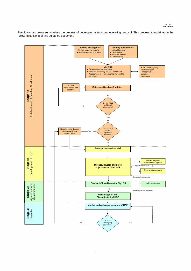
The flow chart below summarises the process of developing a structural operating protocol. This process is explained in the following sections of this guidance document.
5
1.1 Review of existing data In many cases there is likely to be relevant existing data relating to the structure in question or the river corridor and floodplain where it is located. It is important to review the available data to gain an understanding of baseline conditions at the site and inform HOP development. A list of typically useful data and likely sources is provided in Table 1. Table 1 Suggested data and possible sources Type of data Specific Data Source
Geomorphology Fluvial audits Environment Agency
Catchment baseline surveys Environment Agency
Geomorphological audits Environment Agency
River enhancement information Environment Agency/Natural England
Sediment transport modelling records Environment Agency
Topographic survey Environment Agency
Catchment Flood Management Plans Environment Agency
Ecological Fisheries surveys Environment Agency
EC salmonid and cyprinid reaches Environment Agency
Macrophyte survey data Environment Agency
SSSI Citation Natural England
SSSI Unit condition Natural England
Water resources Alleviation of low flow schemes Environment Agency
Water Level Management Plan (WLMP) Environment Agency
Catchment Abstraction Management Strategies Environment Agency
Flood risk modelling outputs Environment Agency
Water level gauging information Environment Agency
Historical Landuse change Environment Agency
Historical maps Environment Agency/internet (old-maps.co.uk)
Landowner maps Environment Agency/Natural England
Structure design document Environment Agency
While every effort should be made to collect as much relevant information as possible there will be cases where information is limited. More detailed information is likely to be available for structures located in a SSSI where a WLMP is available or along “main” rivers monitored by the Environment Agency.
1.2 Identification of stakeholders Consultation with all relevant stakeholders is critical to development of the HOP and allows their views and interests to be taken into account. A list of likely stakeholders is shown below, although this should not be considered exhaustive:
• Environment Agency (including representatives from Fisheries, Recreation and Biodiversity, Water Resources, Asset System Management, and Operations Delivery)
• Natural England • Landowner (s) • Structure owner(s) • Structure operator(s) • Fishing clubs • Abstraction licence holder(s)
If the site is located within a SSSI, the nominated Natural England officer is likely to be able to provide details of relevant local stakeholders and potentially also details of fishing clubs and other river users. If there is a WLMP, the Environment Agency WLMP contact is likely to hold contact details for relevant stakeholders. If the site is not within a SSSI, the Environment Agency (particularly the Asset System Management and Operations Delivery teams) are likely to hold relevant information. It is useful to record landownership in the form of an annotated map, if this has not already been done. It is important to consider stakeholders located upstream and downstream of the structure as well as those directly involved with management of the structure, as they may also affected by flow and water level management control using the structure.
Stage 1: Establishment of Baseline Conditions

6
Having identified all relevant stakeholders, it is recommended that an introductory leaflet is distributed that describes the nature and purpose of hatch operating protocols and outlines the intention to develop one for the structure in question. This leaflet provides an opportunity to begin the consultation process and provides context for the initial site visit (see next section). An example leaflet is available on the STREAM website (www.streamlife.org.uk).
1.3 Initial Site Visit Arranging a site visit with key stakeholders provides a good opportunity to build on existing relationships and gain a first hand understanding of the site. The key aims of the initial site visit are to: • Make direct, face-to-face contact with key stakeholders. • Establish Natural England’s assessment of current SSSI condition (if the site is in a SSSI) and any priorities for
improvement. • Record the current condition and operation of the structure. • Identify potential issues, concerns or conflicts of interest at the site. • Obtain stakeholders’ views on future operation. • Facilitate initial discussions regarding to potential changes already identified through previous work. • Take photographs of the structure(s) and key features of the site. • Record the National Grid Reference of the structure(s). If it is not possible to involve all stakeholders in the site visit, alternative consultation methods must be used to ensure that the views of those not able to attend are obtained and included in the HOP development process.
1.4 Determining Baseline Conditions Following the review of available data and initial site visit, understanding of the baseline conditions at the site should be documented so that all the relevant information required to develop the HOP is collated in one place. A structured format for presenting the baseline conditions, with a brief description of the relevant information under each heading, is provided in Table 2. A worked example of a baseline conditions table from one of the seven pilot HOPs is contained in Appendix A for further information. Table 2 Example table for the presentation of baseline information.
Heading Required Information Information Source
Pilot Structure Insert the recognised name of the structure Environment Agency, Natural England, local stakeholders
Function Function of the structure eg. abstraction for public water supply, flood prevention, aesthetics.
Environment Agency WLMP or Operations Delivery teams, local stakeholders.
Relevant WLMP(s) If a WLMP exists for the river, insert the relevant name and unit number. WLMP.
Relevant SSSI/SAC/SPA units & condition
If the structure is located within a designated site include all the relevant unit numbers and their condition. Natural England website.
Overview of Location Include a location map of the site, labelling all the structures, key features and any SSSI Units.
Ordnance Survey 1:10000 mapping, Natural England website.
Site Description A general description of the site and the nature and purpose of any structures. Findings of initial site visit, local stakeholders.
Landowner (s) Name and location of landowner(s) including upstream and downstream of the site.
Natural England, Environment Agency, WLMP.
Structure owner/operator The current owner and operator of the structures. Natural England, Environment Agency, WLMP.
Current Operation Details of how the structure is currently operated and the justification for the operation. This should include whether any existing abstraction or impoundment license conditions apply, and quantitative details of the extent of hatch opening, timing and resulting water levels wherever possible.
Information obtained directly from the operator, findings of the initial site visit.
Potential constraints / problems with current operation
Constraints include physical and environmental constraints. Problems may reflect both actual problems and identified conflicts of interest.
Findings of initial site visit, responses to initial consultation leaflet.
Potential opportunities / improvements in operation.
Opportunities may include enhancement of channel or floodplain conditions due to changes in flow or water level management, as well as practical operational improvements.
7
At this stage, key opportunities for enhancement and potential constraints should have been identified. This will involve obtaining the views of all relevant Environment Agency and Natural England staff and all local stakeholders involved. Potential opportunities include: • Increase in flow velocities, often resulting in reduced
siltation (particularly upstream of structures). • Easement of fish passage. • Changes in apportionment of flow between
connected channels to provide more appropriate water levels or flow conditions.
• Increase in wetness of adjacent floodplain wetland habitats.
• Reduction of flood risk. • More appropriate timing or coordination of hatch
operation involving more than one structure. • Reduce build up of debris and weed.
Constraints could include: • Structures that do not operate as designed. • Physical dimensions or operational design of
structure that limited the extent of change that is possible.
• Migratory and spawning habits of fish. • Existence of abstraction and eeling licences. • Legal obligations e.g. ensuring fish passage under the Salmon and freshwater fisheries act.
1.5 Do we have sufficient information?
It is desirable to obtain as much information relating to the structure and its operational and environmental context as possible. However, in some cases information may be limited. The list below indicates the information that is essential to the development of an appropriate HOP. If any of this information is missing, further consultation and research should be carried out prior to setting draft objectives:- • Function of the structure. • Condition of designated site(s) (if located within a designated site). • Landowner, structure owner and operator details and views on operation. • Nature of current operation. • Potential opportunities and constraints. Much of this essential information can be obtained through consultation with stakeholders. Where it is not possible to contact the relevant stakeholders, it will prove extremely difficult to develop and implement an appropriate HOP.
1.6 Is change in current operation desirable? When the necessary baseline information has been collected and recorded, consultation should be undertaken with the Environment Agency and Natural England and local stakeholders as required to confirm that the information accurately reflects existing knowledge of the structure. The agreed baseline conditions should then be used to inform a decision as to whether a change in operation is desirable or whether the current operation is considered best practice. Some simple guidance on making this decision is contained in Table 3, although these considerations will vary according to the site. Table 3 Deciding if a change in operation is desirable
Circumstances where a change in operation is likely to be required:
Circumstances where current operation is likely to be best practice:
The structure is not operated with the interests of the designated site in mind.
Channel and floodplain designated sites are already in favourable condition. Changing the operation would have no obvious beneficial effect on the designated site
There are identified, realistic opportunities for improvement in operation of the structure, including for habitat enhancement, flood risk, or operation and maintenance purposes.
There are no identified opportunities for improvement.
There are obvious conflicts of interest between current operation and stakeholder requirements.
There are no obvious conflicts of interest between current operation and stakeholder requirements.
It is practically feasible to implement changes to structural operation. Identified constraints limit alternative operation of the structures.
It is unlikely to be within the scope of the development of a HOP to implement structural changes, or changes to the nature of eeling and abstraction licenses associated with the structures or channels involved. The HOP should therefore aim to reach a balance between the requirements of the HOP and the constraints that exist. If structural changes are required this could be delivered through the WLMP process or from the agri-environment capital works scheme.

8
2.1 Setting HOP objectives Setting clear and achievable objectives is critical both for the development and future success of the HOP. Specific objectives will ensure that the HOP remains focussed on the opportunities identified to improve operation, provides the basis for operation of the structure(s) concerned and will be of value in the future in assessing the “success” of the HOP itself. There are a number of considerations to take into account when setting objectives for the HOP:
1. Consideration of the conservation objectives and current condition of designated sites and the causes underlying this condition. Where the HOP relates to a designated site, the conservation objectives for the site should be reviewed. Causes of unfavourable condition and conflicts with conservation objectives should be identified. This may include factors such as inappropriate water levels, flow velocities, land drainage, water abstraction, impoundment or siltation. The objectives of the HOP may include resolution of one or several of these issues.
2. Legal requirements
Although the overall HOP is voluntary, certain aspects are legal requirements e.g. allowing fish passage under the Salmon and freshwater fisheries act. Mandatory legal requirements should be clearly identified as separate from voluntary aspects of the HOP.
3. Requirements of local stakeholders.
Landowners, structure owners, structure operators, fishing clubs and other stakeholders are likely to have objectives for the site that are unrelated to conservation. These may include maintaining meadows for grazing, irrigation of crops, water supply to fish farms, eeling activities or water abstraction. The overall aims of the HOP will need to balance conservation requirements with the needs of other river or floodplain users. If a change in operation is considered desirable, the inclusion of change in the objectives for the HOP will need to be negotiated and discussed with stakeholders.
4. Physical limitations of structural operation.
It is imperative that any proposed objectives are achievable through physical operation of the structure. It is unlikely to be within the scope of the HOP to implement any structural changes and therefore it must be possible to satisfy the objectives using the resources currently available to the operator.
5. Consideration of the function of the individual structures.
If there is more than one water level control structure at the site for which the HOP is being developed, specific objectives will need to be set for each structure. These should aim to meet the overall HOP objectives whilst not compromising the overall function of the structure eg. flood prevention, flow apportionment or fish passage.
Stage 2: Development of the HOP
9
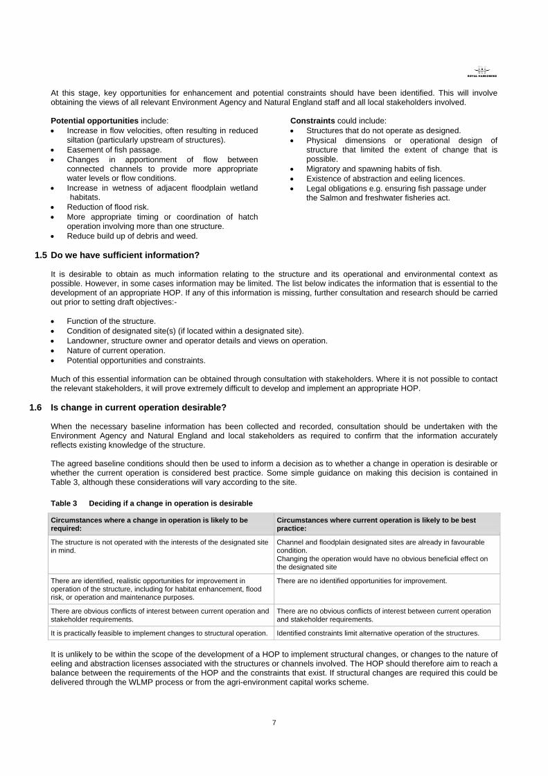
2.2 Drafting the HOP Having set the overall objectives for the HOP, a draft HOP should be developed providing simple and clear instructions that enable these objectives to be met. A template has been developed for the HOP as part of this project. A generic example HOP template is described in detail in this section and illustrated in figures 1, 2 and 3. Generic names are used for rivers, locations etc. Page 1 should include the following: • Purpose - A brief description of the purpose of HOPs in general. • Golden rules for fish passage - These have been developed in consultation with the Environment Agency and Natural
England and provide general rules for fish passage. These can be adjusted to account for the main fishery interests and specific timings relating to the location in question.
• Location of structure - A brief description of the location of the structure and a map locating the site in the river catchment.
• Review and monitoring - Include details of how the HOP will be reviewed and monitored including the frequency of review and responsibilty for agreed monitoring activities.
• Agreed objectives at the site - List the agreed overall HOP objectives and highlight any that are a legal requirements. • Agreement to hatch operating protocol - Include space for all relevant stakeholders to sign to indicate their
agreement to the HOP. Figure 1 – Page one of an example HOP Hatch Operating Protocol: Willow Hatches Purpose Location of structures at Willow Hatches Sluice and hatch operation is a key factor in managing water levels on the River Red and its tributaries. With over 100 weir and hatch structures throughout the catchment, they make a vital contribution to water level management within the river and adjacent floodplain. The purpose of Hatch Operating Protocols is to document agreed best practice guidance on how structures should be operated in order to both sustain the internationally important habitats along the river and meet the needs of river users.
Willow Hatches are located to the west of Ambridge on the River Blue There are 3 structures at the site which are currently operated to apportion flow between the main river and two side channels (see map overleaf):
• Willow Hatches • Eel Stream Hatches • Lake Feed Hatches
The Eel Stream flows through the gardens of Willow House and is important for aesthetic reasons. The northern side channel feeds an ornamental lake to the north.
Golden rules for fish passage Hatches should be operated to achieve optimum attracting flow for fish in order to ease their passage upstream. This will meet the following conditions: • The greatest flow velocity, to attract fish should be at one point and along one channel
(where the channel divides). • Uninterrupted flow should be maintained through at least one hatch. • There should be no obstruction at this flow point – the bottom of the hatch will be clear of the
water (i.e. visible air space between the water surface and the hatch) and kept clear of debris.
• The head difference (the difference between water surface level above and below the sluice) at the weir structures should be kept as low as possible, consistent with other factors.
• The main period of concern is between November and June because this is the primary time for fish spawning and fish passage.
• Open apertures of a gate should be a minimum size of 0.3m x 0.3m, with a head drop of less than 0.6m. A head drop exceeding 0.6m may cause an obstruction, requiring investigation.
• At a head drop of less than 0.6m, obstruction to migration may still occur and is dependent on factors such as approach conditions and hatch operation.
• Spreading the flow across the structure should be avoided, particularly at low flows.
Review and monitoring The protocol will be reviewed annually by representatives of Willow Estate, Natural England and Environment Agency. • The Environment Agency will be responsible for occasional monitoring of the hatches and an
investigation into the river condition / macrophyte community upstream of that hatches and in the Eel Stream.
Agreed objectives at this site Agreement to Hatch Operating Protocol (described overleaf) 1. Allow fish passage all year round (legal requirement) 2. Minimise bank erosion downstream. 3. Keep sufficient water in the Eel Stream to maintain flow through Willow House gardens and
to allow salmon passage while minimising flooding of the field opposite the house. 4. Give priority to maintaining flow in the Eel Stream rather than feeding the ornamental lake.
Environment Agency Signed………………………. Print name………………………… Date…………………………………
Natural England Signed………………………. Print name………………………… Date…………………………………
Willow Estate Signed………………………. Print name………………………… Date…………………………………
Willow Hatches
Willow Hatches
10
Figure 2 – Page two of an example HOP
Page 2 should consist of a location map of the site including the following: • Base mapping - 1:10,000 Ordnance Survey base mapping is recommended. • Structure and watercourse labels - the location of all water level control structures within the site. • Photographs - a photograph of each individual structure should be included with the labels to aid identification in the field. • Annotated notes – notes should be included describing any other key features of the site that are referred to or are of
relevance to the HOP. Page 3 should contain the following information relating to each individual structure:- • National Grid Reference – can be taken in the field using GPS or measured using GIS where the structure is marked on
OS mapping.
• Annotated photograph –should be the same photograph used on Page 2 of the HOP.
• Hatch specific objectives – individual objectives should be developed to balance achievement of the overall HOP objectives and function of the structure.
• Agreed operation; - quantitative details, including timing, sequencing, extent of hatch opening and resulting water levels should be included wherever possible.
• Owner and operator details – may be different for different structures at the same site. The nature of the guidance relating to the agreed operation will vary according to the type of the structure and feasibility of measurements being made by the operator (e.g. gauge boards). It is not anticipated that the HOP should provide guidance for maintenance or safe practices of operation, as ultimately this is the responsibility of the owner/operator and is often based on long-term experience with the particular structure.
Lake Feed Hatches
Ornamental Lake
Willow Hatches
Eel Stream Hatches
Northern Side Channel
Eel Stream
Concrete abutment to gauge
11
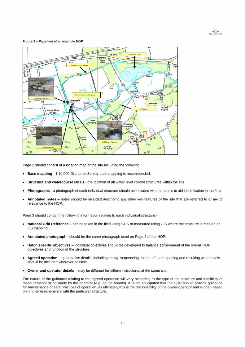
Figure 3 - Page 3 of an example HOP Willow Hatches Eel Stream Hatches Lake Feed Hatches National Grid Reference – AB0123456 National Grid Reference – AN123457 National Grid Reference – AB123458
Function Control the distribution of flow between the main river and two side channels (the northern channel and the Eel Stream to the south)
Function Control flow from the Main River to the Eel Stream.
Function Controls flow from the Main River to the northern side channel which feeds an ornamental lake.
Hatch Specific Objectives • Minimise downstream bank erosion. • Minimise flood risk in Ambridge. • Maintain sufficient flow in Eel Stream to enable fish
passage.
Hatch Specific Objectives • Maintain sufficient flow in Eel Stream to enable fish passage
and to keep water flowing through Willow House Gardens. • Prevent flooding of paddock opposite Willow House.
Hatch Specific Objectives • Relieve flood pressure downstream at times of very high
flows. • Maintain flows to the ornamental lake downstream for
aesthetic purposes.
Agreed Operation • The desired river level is within 45cm of the top of the
concrete abutment located just upstream on the left hand bank.
• Primarily gates 1 and 6 should be used to control river levels to minimise erosion.
• In low flows gates 1 and 6 should be lowered sufficiently to maintain flow in the Eel Stream.
• In high flows 4-5 gates to be opened.
Agreed Operation In normal flows:- • Hatch 1 kept 50% open. • Hatch 2 kept 25% open. In low flows:- • Hatch 1 and Hatch 2 kept 100% open.
Agreed Operation • Hatch 1 and 2 should be shut at all times in normal flows. • Hatch 3 should be 25% open to feed ornamental lake. • In very high flows, all hatches to be opened to reduce
flooding of the paddock downstream.
Owner: Willow Estate - Mr. Yellow Current Operator: Mr. Orange - River Keeper
Owner: Willow Estate - Mr. Yellow Current Operator: Mr. Orange - River Keeper
Owner: Willow Estate - Mr. Yellow Current Operator: Mr. Orange - River Keeper
Hatch 1 Hatch 6
Hatch 1 Hatch 2Hatch 1 Hatch 2
Hatch 3
2.3 Discuss, develop and agree draft objectives and HOP Since the HOP is not a legally binding document (although it may include legal requirement associated with fish passage), the future success of any protocol depends largely on agreeing the objectives and proposed operation with all relevant stakeholders. Discussion with local stakeholders is therefore critical to agreeing the objectives and proposed operation of the structure(s) in question. The most effective method of consultation with local stakeholders is through face-to-face meetings. Although arrangement of the necessary meetings and reaching agreement can take considerable time, it is important that this process is not rushed for the agreed HOP to be successful. Agreeing the draft objectives and HOP should be done using a tiered approach to ensure that all comments are incorporated in sequence. Tier 1 – Steering group A meeting should be held with key Natural England and Environment Agency contacts to obtain their comments on the draft objectives and HOP. Revisions should be made to the HOP to take account of any issues raised prior to further circulation. Meetings may be held to discuss more than one HOP should several be in the process of development in the same area. Tier 2 – Wider consultation group The revised HOP should be circulated to key interest groups, likely to include representatives of other Environment Agency functions, the structure operator and landowner(s) directly involved. It is preferable if the HOP can be discussed face-to-face with local stakeholders to obtain their buy-in to the HOP. If they have further comments, the HOP should be revised in close consultation with Natural England and the Environment Agency to ensure that additional revisions do not conflict. Face-to-face meetings are the most effective method of obtaining comments from stakeholders and provide an opportunity for two way discussion of the issues involved. In the event that this is not possible, email or post can be used to circulate the HOP, followed by discussion by telephone.
12
3.1 Finalise HOP When final comments from all stakeholders have been received and incorporated, the HOP should be sent to all stakeholders for final agreement. This can be done using e-mail or post, since the relevant issues should already have been discussed in the previous round of consultation on the draft HOP. There should also be few additional comments at this stage in finalising the HOP. Comments should only be incorporated if they are agreeable to all parties
3.2 Obtain sign off and disseminate final HOP Once all parties have agreed to the final HOP, the final document needs to be circulated for signature by all parties. The most effective method for achieving sign-off is to arrange a meeting with Natural England and the relevant stakeholders (landowner/structure operator). The HOP should then be signed by the Environment Agency and a signed copy circulated to all interested parties. In the event of a face-to-face meeting proving problematic the HOP could be posted to stakeholders to sign individually before forwarding on in sequence until all relevant parties have signed the document. The signed HOP should be scanned to create an electronic copy that is reproducible. Copies of the HOP should then be printed and issued to relevant parties. It is recommended that the key stakeholders are issued with a laminated copy of the HOP as this will be more durable and could potentially be kept on-site adjacent to the structure or in a site office.
4.1 Monitor and review performance of HOP The HOP should be continually monitored and it is recommended that it is formally reviewed after the first year of its implementation so that stakeholders have an opportunity to discuss any issues or concerns. Monitoring requirements will depend on the objectives of the HOP and may be limited to qualitative, informal monitoring by operators who regularly visit the structure. More quantitative monitoring techniques could include: • Repeated SSSI condition assessment • Analysis of routine monitoring data already been
collected by the Environment Agency. • Recording water levels using gauge boards. • Measuring of changes in silt depths. • Physical habitat mapping.
• River Corridor Survey. • Monitoring water levels on the floodplain. • Monitoring plant growth in the channel and/or on the
floodplain. • Monitoring upstream or downstream fish populations
to assess improvement in fish passage. Monitoring activities may be undertaken by the Environment Agency, Natural England and the landowner/structure operator and responsibilities should be agreed as part of the HOP. Based on the findings of monitoring a summary of influence on physical and ecological conditions should be drafted as part of the review process.
4.2 Is HOP satisfying objectives? Having reviewed the findings of monitoring, the performance of the HOP should be measured against the original overall HOP objectives. Where structure operation is not currently felt to be fulfilling the objectives of the HOP, causes should be identified where possible. These may include: • Operation of structures other than outlined in the HOP • Misunderstanding of the influence of the structure(s) • Factors outside the influence of hatch operation (e.g. increased fine sediment input upstream or low flows limiting the
reduction in siltation) Where it is felt that the HOP is not being fully implemented, negotiations with relevant stakeholders should be held to understand why. If it is felt that the HOP objectives are not appropriate, changes should be agreed following the approach outlined in Stage 1, section 1.
Stage 3 - Agreement and dissemination
Stage 4 - Evaluation

13
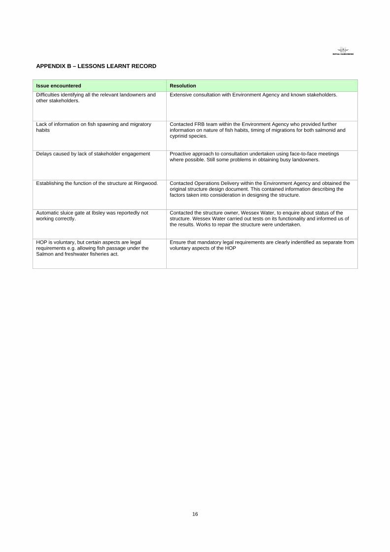
There are a number of issues that may be encountered during the HOP development process and these can often take time
to resolve and delay the development of HOPs. By maintaining a live record of lessons learnt, we hope to make the process of developing HOPs more easy and efficient in the future.
A table highlighting the issues encountered by Royal Haskoning during the development of HOPs and what was done to resolve these issues is contained in Appendix B. A “live” copy of this table is held by the River Avon lead at Natural England in Devizes. Any additional issues encountered in the future development of HOPs should be forwarded to Natural England so that the table can be revised and circulated in the future.
Documenting Lessons Learnt
14
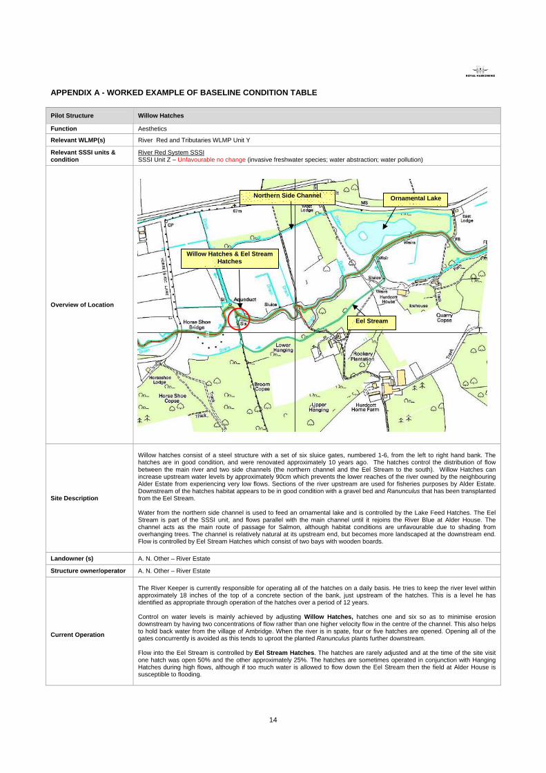
APPENDIX A - WORKED EXAMPLE OF BASELINE CONDITION TABLE Pilot Structure Willow Hatches
Function Aesthetics
Relevant WLMP(s) River Red and Tributaries WLMP Unit Y
Relevant SSSI units & condition
River Red System SSSI SSSI Unit Z – Unfavourable no change (invasive freshwater species; water abstraction; water pollution)
Overview of Location
Site Description
Willow hatches consist of a steel structure with a set of six sluice gates, numbered 1-6, from the left to right hand bank. The hatches are in good condition, and were renovated approximately 10 years ago. The hatches control the distribution of flow between the main river and two side channels (the northern channel and the Eel Stream to the south). Willow Hatches can increase upstream water levels by approximately 90cm which prevents the lower reaches of the river owned by the neighbouring Alder Estate from experiencing very low flows. Sections of the river upstream are used for fisheries purposes by Alder Estate. Downstream of the hatches habitat appears to be in good condition with a gravel bed and Ranunculus that has been transplanted from the Eel Stream. Water from the northern side channel is used to feed an ornamental lake and is controlled by the Lake Feed Hatches. The Eel Stream is part of the SSSI unit, and flows parallel with the main channel until it rejoins the River Blue at Alder House. The channel acts as the main route of passage for Salmon, although habitat conditions are unfavourable due to shading from overhanging trees. The channel is relatively natural at its upstream end, but becomes more landscaped at the downstream end. Flow is controlled by Eel Stream Hatches which consist of two bays with wooden boards.
Landowner (s) A. N. Other – River Estate
Structure owner/operator A. N. Other – River Estate
Current Operation
The River Keeper is currently responsible for operating all of the hatches on a daily basis. He tries to keep the river level within approximately 18 inches of the top of a concrete section of the bank, just upstream of the hatches. This is a level he has identified as appropriate through operation of the hatches over a period of 12 years. Control on water levels is mainly achieved by adjusting Willow Hatches, hatches one and six so as to minimise erosion downstream by having two concentrations of flow rather than one higher velocity flow in the centre of the channel. This also helps to hold back water from the village of Ambridge. When the river is in spate, four or five hatches are opened. Opening all of the gates concurrently is avoided as this tends to uproot the planted Ranunculus plants further downstream. Flow into the Eel Stream is controlled by Eel Stream Hatches. The hatches are rarely adjusted and at the time of the site visit one hatch was open 50% and the other approximately 25%. The hatches are sometimes operated in conjunction with Hanging Hatches during high flows, although if too much water is allowed to flow down the Eel Stream then the field at Alder House is susceptible to flooding.
Willow Hatches & Eel Stream Hatches
Eel Stream
Northern Side Channel Ornamental Lake
15
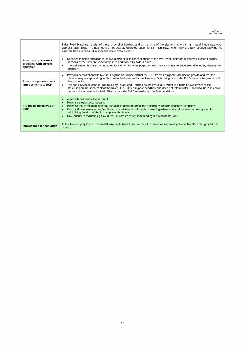
Lake Feed Hatches consist of three undershot hatches and at the time of the site visit only the right hand hatch was open approximately 50%. The hatches are not actively operated apart from in high flows when they are fully opened allowing the adjacent fields to flood. This happens about once a year.
Potential constraints / problems with current operation
• Changes to hatch operation must avoid making significant changes to the river level upstream of Willow Hatches because sections of the river are used for fisheries purposes by Alder Estate.
• The Eel Stream is currently managed for salmon fisheries purposes and this should not be adversely affected by changes in operation.
Potential opportunities / improvements to HOP
• Previous consultation with Natural England has indicated that the Eel Stream has good Ranunculus growth and that the channel may also provide good habitat for bullhead and brook lamprey. Optimising flow in the Eel Stream is likely to benefit these species.
• The non-SSSI side channel controlled by Lake Feed Hatches drains into a lake, which is situated downstream of the structures on the north bank of the River Blue. This is in poor condition and does not retain water. Flow into the lake could be put to better use in the Main River and/or the Eel Stream during low flow conditions.
Proposed objectives of HOP
• Allow fish passage all year round. • Minimise erosion downstream. • Minimise the damage to planted Ranunculus downstream of the hatches by reducing/concentrating flow. • Keep sufficient water in the Eel Stream to maintain flow through House B gardens and to allow salmon passage while
minimising flooding of the field opposite the house. • Give priority to maintaining flow in the Eel Stream rather than feeding the ornamental lake.
Implications for operation In low flows supply to the ornamental lake might have to be sacrificed in favour of maintaining flow in the SSSI designated Eel Stream.
16
APPENDIX B – LESSONS LEARNT RECORD
Issue encountered Resolution
Difficulties identifying all the relevant landowners and other stakeholders.
Extensive consultation with Environment Agency and known stakeholders.
Lack of information on fish spawning and migratory habits
Contacted FRB team within the Environment Agency who provided further information on nature of fish habits, timing of migrations for both salmonid and cyprinid species.
Delays caused by lack of stakeholder engagement Proactive approach to consultation undertaken using face-to-face meetings where possible. Still some problems in obtaining busy landowners.
Establishing the function of the structure at Ringwood. Contacted Operations Delivery within the Environment Agency and obtained the original structure design document. This contained information describing the factors taken into consideration in designing the structure.
Automatic sluice gate at Ibsley was reportedly not working correctly.
Contacted the structure owner, Wessex Water, to enquire about status of the structure. Wessex Water carried out tests on its functionality and informed us of the results. Works to repair the structure were undertaken.
HOP is voluntary, but certain aspects are legal requirements e.g. allowing fish passage under the Salmon and freshwater fisheries act.
Ensure that mandatory legal requirements are clearly indentified as separate from voluntary aspects of the HOP