guidance for flood risk analysis and mapping - fema.gov · guidance for flood risk analysis and...
TRANSCRIPT

Guidance for Flood Risk Analysis and Mapping
Flood Insurance Rate Map Index
May 2014
This Document is Superseded. For Reference Only.

This guidance document supports effective and efficient implementation of flood risk analysis and mapping standards codified in the Federal Insurance and Mitigation Administration Policy FP 204-07801.
For more information, please visit the Federal Emergency Management Agency (FEMA) Guidelines and Standards for Flood Risk Analysis and Mapping webpage (http://www.fema.gov/guidelines-and-standards-flood-risk-analysis-and-mapping), which explains the policy, related guidance, technical references, and other information about the guidelines and standards process.
Nothing in this guidance document is mandatory other than standards codified separately in the aforementioned Policy. Alternate approaches that comply with FEMA standards that effectively and efficiently support program objectives are also acceptable.
FIRM Index May 2014 Guidance Document 7 Page i
This Document is Superseded. For Reference Only.

Document History
Affected Section or Subsection Date Description
First Publication May 2014
Initial version of new transformed guidance. The content was derived from the Guidelines and Specifications for Flood Hazard Mapping Partners, Procedure Memoranda, and/or Operating Guidance documents. It has been reorganized and is being published separately from the standards.
FIRM Index May 2014 Guidance Document 7 Page ii
This Document is Superseded. For Reference Only.

Table of Contents 1.0 Flood Insurance Rate Map (FIRM) Index Layout....................................................................... 1
2.0 Database Linkages ................................................................................................................... 2
3.0 Base Map Elements .................................................................................................................. 3
4.0 Panel Information...................................................................................................................... 4
5.0 Collar Information ..................................................................................................................... 4
5.1 Title Block ............................................................................................................................. 4
5.2 Scale Bar .............................................................................................................................. 5
5.3 North Arrow ........................................................................................................................... 5
5.4 Projection .............................................................................................................................. 5
6.0 Map Service Center Deliverables .............................................................................................. 5
7.0 Distribution to Communities ...................................................................................................... 6
7.1 Product Distribution ............................................................................................................... 6
7.2 FIRM Index Distribution ......................................................................................................... 6
8.0 Regional Flexibility .................................................................................................................... 7
9.0 PMR Considerations for FIRM Indexes ..................................................................................... 8
9.1 Political Boundary Changes Outside the PMR Footprint ........................................................ 8
9.2 S_Submittal_Info ................................................................................................................. 11
10.0 Partial Countywide Mapping ................................................................................................... 11
11.0 Multiple-County Communities ................................................................................................. 12
11.1 Processing Option 1: Single Jurisdiction ............................................................................. 12
11.2 Processing Option 2: Entire Community Mapped in Only One of the Countywide FIRMs ... 12
11.3 Processing Option 3: Community Split Between Counties .................................................. 12
List of Figures Figure 1 - Multi-Sheet FIRM Index Locator Diagram and Title Block .................................................... 2 Figure 2 - FIRM Index with Key to Communities .................................................................................. 3 Figure 3 - FIRM Index with Preliminary Stamp .................................................................................... 5 Figure 4 - Scenarios Associated with Watershed Projects ................................................................... 8 Figure 5 - 2003 Format FIRM Index with Corporate Limits Note .......................................................... 9 Figure 6 - 2013 11"x17" Format FIRM Index with Corporate Limits Note ........................................... 10 Figure 7 - Corporate Limits Note in 2013 Format FIS Report ............................................................. 11
FIRM Index May 2014 Guidance Document 7 Page iii
This Document is Superseded. For Reference Only.
1.0 Flood Insurance Rate Map (FIRM) Index Layout There is some flexibility in the FIRM Index layout as noted below.
• For a watershed-based Flood Risk Project, FIRM Indexes should be prepared for each of the jurisdictions in the watershed, as applicable. Countywide FIRM Indexes should be prepared for any countywide FIRMs with map changes resulting from the Flood Risk Project and community-based FIRM Indexes should be prepared for any FIRM with map changes that remain community-based.
• Mapping Partners may retain the 2003 FIRM Index layout at the discretion of the Regional Project Officer if the Flood Insurance Study (FIS) Report is not updated to the 2013 specification.
• The 11”x17” FIRM Index layout is customizable to a certain degree based upon space requirements within the following constraints:
o The body of the FIRM Index shall always reside at the top of the page.
o The Panel Not Printed notes, North Arrow, scale bar, projection information, and Map Service Center (MSC) note shall reside at the bottom left.
o The County Locator (where applicable) shall be at the bottom center.
o The Title Block shall be at the bottom right.
o In cases where the list of printed panels does not fit in the title block due to the number of panels, the size of the title block may be increased.
• FIRM Indexes in the new 11”x17” layout can be oriented as portrait or landscape pages, depending on the shape of the jurisdiction being mapped. FIRM Index templates can be found at the following location: http://www.fema.gov/media-library/assets/documents/32786?id=7577
• The county locator map is optional for studies with a single page index.
• The scale used for the FIRM Index is at the discretion of the Mapping Partner. It should be chosen to best reflect the necessary information in a readable format. The FIRM Index may span more than one printed page as necessary. If more than one FIRM Index page is included, only the panels shown on the page should be listed in the Title Block for that page.
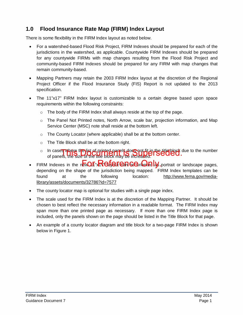
• An example of a county locator diagram and title block for a two-page FIRM Index is shown below in Figure 1.
FIRM Index May 2014 Guidance Document 7 Page 1
This Document is Superseded. For Reference Only.

Figure 1: Multi-Sheet FIRM Index Locator Diagram and Title Block
• If the 2013 11”x17” FIRM Index layout is used but the FIS Report remains in the 2003 format,
the information previously included in tables on the FIRM Index (e.g., map repositories, community dates, notes to users) should be added to a new section at the end of the FIS Report.ID Numbering
Each FIRM Index requires an ID number to be applied to the FIRM Index title block and the FIRM Index file name as described in the FIS Report Technical Reference. The FIRM Index ID number includes a suffix that is advanced each time the FIRM Index is republished with a new effective date. The first issuance of a countywide study will reset the suffix. Example FIRM Index ID numbers are as follows:
• 12345CIND0A for a one-page first time countywide FIRM Index
• A suffix of “A” would also be used the first time the FIRM Index receives a suffix if it does not yet have a suffix. For example, a revision to a countywide FIRM Index created in the 1990’s before the FIRM Index suffix was required would also be numbered as 12345CIND0A.
• 12345CIND1B and 12345CIND2B for a 2-page map revised FIRM Index on its first map revision since receiving a suffix
• 123456IND0C for a community-based one-page map revised FIRM Index on its 2nd map revision since receiving a suffix
2.0 Database Linkages The FIS Report Technical Reference provides a cross walk between the FIRM Database and the components of the FIS Report, including the FIRM Index. The following summarizes the FIRM Database sources of the FIRM Index components.
• All of the panel-specific information, including the FIRM panel number and suffix, FIRM panel effective dates, printed panels, and Panel Not Printed notes are derived from the S_FIRM_Pan table.
• The political entities and their names as shown on the FIRM Index are derived from the S_Pol_Ar table.
• The HUC-8 boundaries and names are derived from the S_Subbasins table where BASIN_TYP = “HUC8”.
FIRM Index May 2014 Guidance Document 7 Page 2
This Document is Superseded. For Reference Only.

• If included on the FIRM Index, the transportation features and labels are derived from the S_Trnsport_Ln table.
• If included on the FIRM Index, the major studied streams and their names are derived from the S_Profil_Basln and/or S_Wtr_Ln and S_Wtr_Ar tables.
• The FIRM Index title block information for jurisdiction name and type, Effective or Map Revised date, and the projection information shown in the collar are derived from the Study_Info table.
Note: The following FIRM Index elements are not currently included in the FIRM Database tables.
• The ID number described above (e.g., 12345CIND0A)
• Surrounding county names that are labeled on the FIRM Index
3.0 Base Map Elements The following guidance applies to FIRM Indexes prepared in the 2013 11”x17” format.
• As noted in Standard 252, all political jurisdictions must be shown and labeled on the FIRM Index. If there is not enough space to label all political entities and their Community Identification Numbers within the FIRM Index, a numbered key may be used for the congested area. If a numbered key is used, it should be placed in an open area of the body of the FIRM Index. An example of a key to communities is shown below in Figure 2.
Figure 2: FIRM Index with Key to Communities
• For communities that have Extraterritorial Jurisdictions, the corporate limits lines that are interior to the Extraterritorial Jurisdiction boundaries should be eliminated on the FIRM Index to reduce clutter. See the Extraterritorial Jurisdiction Mapping and Distribution Guidance document for additional guidance on the depiction of Extraterritorial Jurisdictions.
FIRM Index May 2014 Guidance Document 7 Page 3
This Document is Superseded. For Reference Only.

• State parks and national parks no longer need to be shown or labeled on the FIRM or FIRM Index.
• HUC8 basins should, at a minimum, cover the entire county and should be clipped to the county boundary.
• Transportation and streams, if shown on the FIRM Index, are a subset of the vector data in the FIRM Database.
• Major transportation features (i.e., Interstate Highways, U.S. Highways, State Highways, County Highways, and railroads) should be shown and labeled on the FIRM Index, where appropriate, in order to facilitate ease of geographic location by the user. However, these features are not required.
• Major studied stream should be shown and labeled on the FIRM Index, where appropriate, in order to facilitate ease of geographic location by the user. However, these features are not required.
4.0 Panel Information The following guidance applies to FIRM Indexes prepared in the 2013 11”x17” format.
• When Physical Map Revisions (PMRs) include Panels Not Printed within the PMR footprint, each revised FIRM panel affected by the PMR should get a new effective date and have its suffix advanced to the next letter. This includes advancing the suffix on the FIRM Index for panels that are not printed if there has been a change to the Panel Not Printed. For example, a FIRM panel that is newly created as a result of a change in map scale, but not printed, would have its suffix advanced. Other examples of changes that would advance the suffix include a change in the Panel Not Printed footprint, absorption of the panel onto a different FIRM Index, or the rare circumstance where a Panel Not Printed is all one homogenous flood zone that is changing.
• As noted in Standard 253, FIRM panels shown on the index should be labeled with the four-digit panel number and suffix.
• Effective dates shown as 9/9/9999 in the FIRM Database should not be printed on the FIRM Index.
• The 0.75-point white halo is optional for any annotation on the FIRM Index other than the panel numbers. However, halos should be used for annotation that overprints other features.
• The Notes to Users, Map Repositories, and Listing of Communities table should not be included on the FIRM Index. These items are now shown in tables within the FIS Report.
5.0 Collar Information The following guidance applies to FIRM Indexes prepared in the 2013 11”x17” format.
5.1 Title Block
• The jurisdiction name and type (e.g., Flood County, USA and Incorporated Areas) shown in the FIRM Index title block should follow the same guidance provided for FIRM Panel title blocks regarding how to list the jurisdiction’s name and type.
FIRM Index May 2014 Guidance Document 7 Page 4
This Document is Superseded. For Reference Only.

• FIRM Indexes that are issued as Preliminary or Revised Preliminary should be stamped “Preliminary” or “Revised Preliminary” as appropriate, in a manner similar to that shown on the FIRM Panel title block. An example of a FIRM Index title block with a “Preliminary” stamp is shown below in Figure 3. No effective date or map revised date should be shown on the preliminary or revised preliminary title blocks.
Figure 3: FIRM Index with Preliminary Stamp
• Even though the FIS Report cover includes the Effective or Map Revised date or the “Preliminary” or “Revised Preliminary” stamp and the FIRM Index is included within the FIS Report as Figure 1, the date or stamp is also needed on the FIRM Index title block, since the FIRM Index is often provided separately for reference with the FIRM Panels.
• The version number (i.e., VERSION NUMBER 2.3.3.2) does not need to be included in the FIRM Index title block since it is included on the FIS Report cover.
• A graphic image of the FEMA logo suitable for use in the FIRM Index title block can be found at http://www.fema.gov/media-library/assets/documents/32786?id=7577.
5.2 Scale Bar The scale bar shown on the FIRM Index should reflect the actual scale of the FIRM Index body. It does not need to be an even increment, although the Mapping Partner may choose an even increment map scale if it best suits the FIRM Index layout.
5.3 North Arrow The FIRM Index should follow the FIRM panel orientation (i.e., grid north at the top of the map sheet).
5.4 Projection The projection used for the FIRM Index and shown in the FIRM Index collar should match the projection used for the FIRM panels (e.g., State Plane, UTM, or a local projection).
6.0 Map Service Center Deliverables The following guidance applies to FIRM Indexes prepared in the 2013 11”x17” format.
FIRM Index May 2014 Guidance Document 7 Page 5
This Document is Superseded. For Reference Only.
• In addition to being included in the FIS Report as Figure 1, the FIRM Index is also delivered to the MSC as a georeferenced PNG file so it can be posted on the MSC website for viewing in the Product Catalog. The PNG file should be accompanied by a file providing coordinate information that allows the images to be georeferenced (e.g., a pgw file).
7.0 Distribution to Communities This section provides an overview of preliminary and final distribution of FIRM products including the FIRM Index to communities.
7.1 Product Distribution Distribution of the flood hazard data is summarized below.
• Preliminary distribution of the hardcopy map panels and the digital flood hazard data is made by the Production and Technical Services contractor or the Regional Support Center.
• Preliminary digital flood hazard data, including new or revised FIRM panels, the FIRM Index, FIS reports, and FIRM Databases are provided to the public by the MSC at the Preliminary Flood Hazard Data webpage, which can also be accessed via the MSC’s Product Catalog web page.
• During the period between the Letter of Final Determination date and the effective date, future digital flood hazard data, including new or revised FIRM panels, the FIRM Index, FIS reports, and FIRM Databases are provided to the public by the MSC at https://msc.fema.gov. At the same time these data are posted to the website, the MSC also provides copies of the hardcopy map panels and the digital flood hazard data to affected community officials.
• Once the flood hazard data are effective, the FIRM Database data are provided for download via the National Flood Hazard Layer (NFHL) only.
7.2 FIRM Index Distribution Because the mapped communities share one FIS report and FIRM Index when they are prepared in the countywide format, the preliminary and final distribution of the FIRM Index to jurisdictions is as follows.
• For FIRMs prepared for the first time in the countywide format, the FIRM Index is distributed to all jurisdictions in the county. Each jurisdiction also receives the FIS report and only those FIRM panels on which they are located, as itemized on the FIRM Index Listing of Communities table or the FIS Report Listing of NFIP Jurisdictions table.
• For revisions to existing countywide FIRMs that are prepared with a FIRM Index in the 2013 11”x17” format, the revised FIRM Index is distributed to all communities in the county along with a letter explaining why they are receiving the FIRM Index. In addition, the revised FIRM panels are distributed only to those communities that are located on panels that are being revised.
• For revisions to existing countywide FIRMs with a FIRM Index in the 2003 format (i.e., that have the FIRM Index Listing of Communities table) the FIRM Index, revised FIRM panels, and FIS Report are distributed only to those communities located on revised panels.
FIRM Index May 2014 Guidance Document 7 Page 6
This Document is Superseded. For Reference Only.

• All communities within a county whose FIS Report is being updated to the 2013 format should receive a copy of the new FIS Report, regardless of whether they are affected by the new studies or are outside the project watershed altogether.
• For PMRs, the FIS report/FIRM Index should be delivered to every community in the county regardless of PMR footprint with “For informational purposes only” notification as applicable. This is because many community ordinances adopt specific versions or effective dates of the FIRM and FIS and if the PMR affects the version or effective date of the FIS report, then all communities affected by the new FIS must be notified so they can re-adopt the FIS even if there are no changes to FIRM panels within the community.
• Additional distribution of preliminary products, including the FIRM panels, FIS report, and FIRM Index may be made by Mapping Partners to other interested groups such as Levee Districts, the U.S. Army Corps of Engineers, or other governmental agencies that may manage aspects of the Special Flood Hazard Areas. Identification of these additional entities should be made during Discovery and distribution of hardcopy and/or digital products to them should be included in the Mapping Activity Statement (MAS) for the Flood Risk Project.
8.0 Regional Flexibility In cases where only a small portion of a county is affected by a new study (County 3 in Figure 4 below), the discretion is left to the Regional Project Officer to decide whether to update the FIS Report in that county to the new format as part of the watershed project, or to amend the information for those flooding sources in the format of the previous countywide FIS Report. The decision about the format of the FIS Report and FIRM Index format should be made during Discovery and should be noted in the MAS for the Flood Risk Project.
If the FIS Report is prepared in the new format, the FIRM Index must also be prepared in the new 11”x17” layout.
While it is recognized that flexibility in the application of these guidelines is needed, based on unique circumstances or budget constraints, it is strongly encouraged that every effort be made to transition FIS Reports to this new format.
Whenever possible, it is advisable to update the FIS Report to the new format for each county that is affected by the new studies (Counties 1, 2, and 3 in Figure 4). However, in cases where only a small portion of a county is affected by the new studies (County 3), the discretion is left to the Regional Project Officer to decide whether to update the FIS Report in that county to the new format, or to amend the information for those flooding sources in the format of the previous countywide FIS Report.
FIRM Index May 2014 Guidance Document 7 Page 7
This Document is Superseded. For Reference Only.

Figure 4: Scenarios Associated with Watershed Projects
9.0 PMR Considerations for FIRM Indexes The following guidance is provided for PMRs where only a portion of the panels within a county or community are being updated. The footprint of the PMR is defined as the boundary or boundaries of the FIRM panels affected by the PMR’s study area (per SID 551).
Regardless of the extent of the PMR footprint, the submitted FIRM Index and FIS Report should encompass the entirety of the original jurisdiction extents (i.e., if the PMR is revising portions of a countywide study, the FIRM Index and FIS Report must remain countywide).
9.1 Political Boundary Changes Outside the PMR Footprint Often when processing a PMR, political boundary updates are provided by local jurisdiction(s) that extend beyond the footprint of the PMR. If updated political boundaries are made available outside the PMR footprint they should be reflected on the FIRM Index and in the Listing of Communities table. Details for the scenarios for both the 2003 and 2013 11”x17” FIRM Indexes are provided below.
• FIRMs will not be reprinted just to show updated political boundaries if there are no flooding changes on the panel.
• Including the revised political boundaries in the NFHL beyond the PMR footprint and not republishing FIRMs just to reflect these corporate limits changes means that the NFHL may not be able to be used to reprint an effective FIRM exactly as published. It also means that subsequent Letters of Map Revision (LOMRs) that start with NFHL data will reflect the revised political boundaries which may not match the previous effective FIRM panel.
• The revised political boundaries should be documented in the FIRM Database with a new SOURCE_CIT abbreviation and the source of the data should be documented in the accompanying metadata file.
FIRM Index May 2014 Guidance Document 7 Page 8
This Document is Superseded. For Reference Only.
9.1.1 2003 Format Studies This section provides details for how political boundary changes outside a PMR footprint should be handed for 2003 format studies.
9.1.1.1 FIRM Index
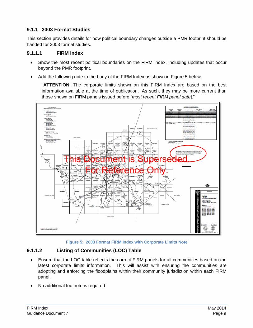
• Show the most recent political boundaries on the FIRM Index, including updates that occur beyond the PMR footprint.
• Add the following note to the body of the FIRM Index as shown in Figure 5 below:
“ATTENTION: The corporate limits shown on this FIRM Index are based on the best information available at the time of publication. As such, they may be more current than those shown on FIRM panels issued before [most recent FIRM panel date].”
Figure 5: 2003 Format FIRM Index with Corporate Limits Note
9.1.1.2 Listing of Communities (LOC) Table
• Ensure that the LOC table reflects the correct FIRM panels for all communities based on the latest corporate limits information. This will assist with ensuring the communities are adopting and enforcing the floodplains within their community jurisdiction within each FIRM panel.
• No additional footnote is required
FIRM Index May 2014 Guidance Document 7 Page 9
This Document is Superseded. For Reference Only.

9.1.1.3 Hard Copy FIRM panels (and FIRMettes created from the MSC tool)
• Panels that are a part of the PMR will show the new corporate limits. Non-revised panels will continue to have outdated corporate limits. This may result in mismatches in political boundaries between published FIRMs with different effective dates. However, the NFHL will always reflect the most updated political boundaries provided to FEMA.
9.1.1.4 FIRM Database
• The FIRM Database as reflected in the NFHL will have the most recent corporate limits
• S_POL_AR will be submitted for the entire county to enable the NFHL to show the most current corporate limits as of the latest study.
• The remainder of the submitted FIRM Database may be clipped to the PMR footprint
9.1.2 2013 Format Studies This section provides details for how political boundary changes outside a PMR footprint should be handed for 2013 format studies.
9.1.2.1 FIS Report
• On Table 1 in the FIS Report (Listing of NFIP Jurisdictions) ensure that it reflects the correct FIRM panels for all communities based on the latest corporate limits information. This will assist with ensuring the communities are adopting and enforcing the FIRM panels on which their community falls.
• On the FIRM Index show the most recent political boundaries, including revisions to political boundaries outside the PMR footprint. Add the following note to the body of the FIRM Index as shown in Figure 6 below.
“ATTENTION: The corporate limits shown on this FIRM Index are based on the best information available at the time of publication. As such, they may be more current than those shown on FIRM panels issued before [most recent FIRM panel date].”
Figure 6: 2013 11"x17" Format FIRM Index with Corporate Limits Note
FIRM Index May 2014 Guidance Document 7 Page 10
This Document is Superseded. For Reference Only.

• On Figure 2 in the FIS Report (FIRM Notes to Users) add the following note in the NOTES FOR FIRM INDEX section as highlighted in Figure 7 below (note that this note does not replace the existing FIRM Notes to Users note about corporate limits).
“ATTENTION: The corporate limits shown on this FIRM Index are based on the best information available at the time of publication. As such, they may be more current than those shown on FIRM panels issued before [most recent FIRM panel date].”
Figure 7: Corporate Limits Note in 2013 Format FIS Report
9.1.2.2 Hard Copy FIRM panels (and FIRMettes created from the MSC tool) Panels that are a part of the PMR will show the new corporate limits. Non-revised panels will keep the effective corporate limits. This may result in mismatches in political boundaries between published FIRMs with different effective dates. However, the NFHL will always reflect the updated political boundaries.
9.1.2.3 FIRM Database
• The FIRM Database as reflected in the NFHL will have the most recent corporate limits.
• S_POL_AR will be submitted for the entire county to enable the NFHL to show the most current corporate limits.
• The remainder of the submitted FIRM Database may be clipped to the PMR footprint.
9.2 S_Submittal_Info The final FIRM Database S_Submittal_Info polygon(s) for a PMR should reflect the extent of the new or updated Flood Risk Project and/or redelineated areas. They do not need to match exactly the PMR footprint. Rather, they should reflect areas with new or revised engineering information. The S_Submittal_Info polygon included in the FIRM Database submitted for the Base Map MIP workflow step for the PMR would reflect the entirety of the revised political boundaries if they exceed the extents of the PMR footprint.
10.0 Partial Countywide Mapping If partial countywide mapping is approved by the FEMA Regional Office, a countywide FIRM Index should be prepared showing all FIRM panels in the final paneling scheme. Some panels will use the countywide quad-based paneling and others will retain their existing non-quad-based layout. Any overlapping panels should be clearly numbered and labeled with no duplicated panel numbers.
FIRM Index May 2014 Guidance Document 7 Page 11
This Document is Superseded. For Reference Only.

11.0 Multiple-County Communities The following guidance applies to FIRM Indexes that include multiple-county communities. There are three processing options for multiple-county communities as described below. Other special circumstances may require special handling.
11.1 Processing Option 1: Single Jurisdiction Under this option, the FIRMs of the surrounding counties show the community as an “Area Not Included” (ANI), with no flood hazard or base map information shown, and the community retains the format of its Single-Jurisdiction FIRM. When this option is chosen the community retains its single-jurisdiction FIRM Index. Minor revisions of the adjacent counties may be necessary to ensure that no overlaps or gaps in coverage exist.
11.2 Processing Option 2: Entire Community Mapped in Only One of the Countywide FIRMs
Under this option, the entire community is mapped on a single countywide FIRM and FIRM Index with panels being added to the Flood Risk Project to cover the entire multiple-county community. The prior community-based FIRM and FIRM Index for the multiple-county community are superseded. Any adjacent counties will continue to show the multiple-county community as an ANI on their FIRMs and FIRM Index.
11.3 Processing Option 3: Community Split Between Counties Under this option, areas in the multiple-county community are shown on the countywide FIRMs and FIRM Indexes of their respective counties. The prior community-based FIRM and FIRM Index for the multiple-county community are superseded. However, when Processing Option 3 is chosen, if the processing of any of the contiguous countywide FIRMs that share the subject community are delayed (usually as a result of an appeal, protest, or other flood risk project complication), thereby making it impossible for all countywide FIRMs to become effective at the same time, the multiple-county community shall retain the effective community-based FIRM or previous single- or multiple-county map for the portion of the community in the county with the delayed map. Any processing decisions made must result in continuous and non-conflicting coverage for all land areas being mapped. Once all issues causing the delay are resolved, the assigned Mapping Partner can proceed with the inclusion of the community into each countywide FIRM.
FIRM Index May 2014 Guidance Document 7 Page 12
This Document is Superseded. For Reference Only.