ground water - idaho little salmon river basin - 50 ground water less than 100 acres, all located in...
TRANSCRIPT

CSWP: Little Salmon River Basin - 50
Ground WaterLess than 100 acres, all located in the lowerbasin, are irrigated with ground water as thesole source of water. Using the IDWRvolumetric standard of four acre-feet peracre per irrigation season as a guide forestimating volume of use, the totalmaximum of diversion is about 400 acre-feetof water. Five hundred fifty-five additionalacres are irrigated using ground watersupplemental source (Idaho Department ofWater Resources 1998). The term“supplemental source” means that there areother sources of water for these acres, andthe ground water is used only as asupplement or back-up to the primarysource. Diversion volume for supplementaluse in the Little Salmon River basin rangesfrom a high of four acre-feet per acre, tozero, if the supplemental source is not usedduring an irrigation season. Supplementaluse may add as many as 2,220 acre-feet tothe 400 acre-feet diverted for sole sourceground water rights (Idaho Department ofWater Resources 1998). These volumeestimates do not include any half-acreparcels that may be irrigated in conjunctionwith a domestic use.
4.2.4 Stock WaterMost of the water provided for livestockconsumption in the Little Salmon Riverbasin comes from surface water. Table 4shows the estimated number of livestock in
the Little Salmon River basin. In federalmanagement areas, estimates are based onthe number of grazing permits issued. Inprivately owned areas of irrigated pasture,local experts provided estimates.
Standard water use, as defined by theIDWR, is 12 gallons of water per day forrange cattle and horses, and two gallons perday for sheep. Total stock water use wasestimated by multiplying the number ofgallons typically used in a day by anestimate of days of livestock water use.Total annual livestock water use in the basinis estimated at 18 million gallons, or about56 acre-feet. The estimates do not allow forevaporation and any additional waterrequired other than that which is directlyconsumed, or for the same animals thatpasture in more than one management area.
Up until recently, Idaho water law did notallow diversion of stock water from livestreams to watering troughs unless thelandowner held a permitted water right. Thislaw was a disincentive for livestock ownerswho wanted to develop off-stream waterfacilities for water quality and streamprotection purposes. A law recently passednow allows diversion of in-stream stockwater to troughs without the previouslyrequired water right. Refer to Idaho Code §42-113 for other requirements related to off-stream livestock water facilities.
Table 4. Estimated numbers of livestock by land management/ownership (Sources: 1. Kwader, J., 2. Daly,L., 3. Lake, L., 4. Grinde, P., 5. Dryden, D.).
Land Ownership Cattle Sheep Horses Grazing PeriodBoise Cascade1 1,277 * June-October
Bureau of Land Management2 710 8,000 1 May-October1,070 July
U.S. Forest Service (Nez Perce National Forest)3 355 June-OctoberU.S. Forest Service (Payette Forest)4 2,125 4,000 100-200 July-mid OctoberOther Private Land5 9,000 June-September
* Included in cattle numbers.

CSWP: Little Salmon River Basin - 51
4.2.5 Domestic, Commercial,Municipal, and Industrial
This section describes the amount andsources of water in the basin for domestic,commercial, municipal, and industrial uses.One exception is commercial water, whereno amount is described because of itsminimal use for that purpose. In general,domestic is defined as single family use,commercial is defined as non-manufacturingbusinesses, municipal is defined as in IdahoCode § 42-202B(2) as “municipal provider,”and industrial is defined as manufacturingindustries.
DomesticDomestic use is defined in Idaho Code § 42-111. For the purposes of this analysis,domestic use will be considered one home;with irrigation limited to 1/2 acre and totaluse not exceed 13,000 gallons per day.
According to IDWR records, there areapproximately 100 domestic users of surfacewater in the basin. About 40 percent of theuse is from springs located on or near theusers’ property. If each user were to divert13,000 gallons per day, daily use would total1.3 million gallons (about four acre-feet.)Actual use is undoubtedly a much loweramount because the use of surface water fordomestic purposes is usually seasonal; theremay be no use other than lawn and gardenirrigation. Domestic use from surface wateris scattered throughout the basin, but severalusers may be concentrated on the samespring or small stream. This may result inlocalized supply conflicts that are notindicative of basin-wide water supplies.
Because withdrawals from domestic wellsare not typically measured, actual domesticground water use is difficult to calculatewith certainty. Based on U.S. Bureau of theCensus data (2000), approximately half ofthe homes in the basin are not served by amunicipal system. Assuming each of thesehomes diverts 13,000 gallons a day, dailywithdrawals from the basin would total 6.5million gallons (about 20 acre-feet). Actualuse is probably lower, as it is rare for a userto divert 18 gallons a minute (0.04 cubic feetper second) for 12 hours each day, every day
(13,000 gallons per day, as allowed by Idaholaw.) No map of well locations is providedin this document because the locations havenot been recorded consistently before 1984,and since 1984, locations were onlygenerally located.
Commercial
Surface WaterFor surface water, one commercialswimming pool uses hot springs for its poolsand to heat the buildings. For ground water,several small businesses in the basin that arenot served by municipal systems rely onsmall wells. These uses are minimal.
Municipal
Surface WaterSurface water is used for several communitysystems in the basin. The Pollock WaterUsers system serves 11 residences from aspring that is a tributary to Hat Creek. Threeof these residences have their own wells inaddition to the community system. Othermultiple home uses of surface water arerestricted to non-culinary uses. Subdivisionslocated on Thrush Creek and Boulder Creekhave water right permits to divert waterfrom those creeks for external use.
The city of Riggins’ original municipalsystem diverted water from Squaw Creekinto an open ditch/wooden flume system.Residents not on the flume would bringbuckets to a cistern located near the town’shotel (Manser and Wilson 1983). WhileSquaw Creek diversion is no longer used forculinary water needs, it still suppliesirrigation water (as does the Little SalmonRiver) to city residents and businesses.
Ground WaterMost of the municipal systems in the basinuse ground water. The most significantmunicipal providers are the city of NewMeadows, located in the upper basin, andthe city of Riggins, located at the mouth ofthe Little Salmon River. Municipal use mayinclude some irrigation (lawns and gardens),commercial, and industrial uses, along with

CSWP: Little Salmon River Basin - 52
uses inside domestic dwellings, as well ashook-ups outside of the city limits. Forinstance, in 1997 New Meadows identified11 commercial users on the municipalsystem, and provided service to customersoutside of the city limits (Idaho Departmentof Commerce 1997).
The city of New Meadows has recentlycompleted an upgrade of its water deliverysystem. The Idaho Water Resource Boardhas been a financial partner with the city inthe design and construction improvements,providing $5,000 grants in both 1995 and1997. The current upgrade replaced dead-end lines in the delivery system with aclosed loop system, replaced a well,resurfaced the system’s storage tank, andrepaired the pump on the city’s second well.
The city of New Meadows has filed a claimin the Snake River Basin Adjudication for2.0 cubic feet per second (900 gallons perminute). The claim is based on a licenseissued by the IDWR for 1.3 cubic feet persecond (585 gallons per minute). Thediscrepancy between the claim filed in theSRBA and the previously issued water rightlicense will be resolved during theadjudication process.
The other principal municipality in the basinis the city of Riggins. The city hasmaintained its municipal delivery systemsince it was purchased from a special servicedistrict in the 1970s and has recentlycompleted an upgrade of the system. Thecity of Riggins filed a statutory water rightclaim for 0.71 cubic feet per second(approximately 320 gallons per minute). TheIDWR did not investigate statutory claims,and the actual beneficial use of the waterright has not been verified. The city filed aclaim on the same water right in the SRBAfor 0.89 cubic feet per second(approximately 400 gallons per minute). Thediscrepancy between these two claims willbe resolved in the SRBA process.
Other municipal systems using ground waterinclude one multiple-family system servingfive mobile homes and a 27-space RV park,and another facility of 17 mobile homes and
two cabins. The first system has a waterright license for 9.4 acre-feet per year, andthe second system has not yet beenmeasured by the IDWR.
IndustrialThere is one water right for industrial use inthe basin. It is for a milling operation nearRiggins, and is licensed for 41.3 acre-feetper year.
4.2.6 Water QualityIdaho’s primary water quality protectionresponsibilities lie within the Department ofEnvironmental Quality (DEQ). The DEQworks to implement federal and state waterquality standards, including the regulation ofpollutants that are discharged to the state’swaters. The IDWR also has water qualityresponsibilities as they relate to waterquantity. Comprehensive state water planssuch as this document are generallycoordinated with DEQ’s water qualityprotection efforts.
Water Quality Limited Water BodiesIn 1994, the U.S. Environmental ProtectionAgency (EPA), under the authority ofSection 303(d) of the federal Clean WaterAct, listed the Idaho waters with waterquality problems. These water qualitylimited designations require that the State ofIdaho develop Total Maximum Daily Load(TMDL) standards for these waters. ATMDL is the sum of all contributions for agiven constituent pollutant allowable in aspecific waterway each day, plus someseasonal variations and a margin of safety.The TMDLs must be at or below the levelestablished for the waterway’s designateduses. For instance, the Little Salmon River iscurrently designated as supporting salmonidspawning, coldwater biota, domestic andagricultural water supplies, and recreation.The TMDLs become the basis for plans torestore the water quality to a level thatsupports its designated uses. TMDLs are tobe established for the Little Salmon Riverbasin by the end of 2004.
The proposed 1998 303(d) list for Idahorecommended the Little Salmon River be

CSWP: Little Salmon River Basin - 53
listed only below Round Valley Creek.However, in April of 2000, the EPAamended Idaho’s 303(d) list and the upperLittle Salmon River segment (upstream fromRound Valley Creek) was added back to thelist. The EPA sought the listing becauseavailable data indicated exceedence of thetemperature standard in that stream segment(Shepard 2000).
The eight water quality limited water bodiesin the basin that are not currently meetingapplicable water quality standards forspecific designated beneficial uses–thebasin’s 303(d) streams–are identified inTable 5 (Zaroban 1993). Two reaches,Squaw Creek and the Little Salmon River,were included by the EPA because studiesexist indicating there is a water qualityproblem, but the contaminants and sourceshave not yet been established (Essig 1998).Several water bodies have listed unknowncontaminants or sediment listed as thepollutants. A stream is listed for unknowncontaminants when beneficial usereconnaissance monitoring indicatespossible impairment of aquatic species. Alllisted streams are considered low in priorityfor development of TMDLs, indicating thatthe designated uses may not be fullysupported, but that risks to human health,aquatic life, recreation, economic, oraesthetics of the water body are minimal.
Special Resource Waters andOutstanding Resource WatersThe Little Salmon River and the RapidRiver are designated as “Special Resource
Waters.” Special Resource Waters arespecific water bodies identified by the DEQas needing intensive protection to preserveeither outstanding or unique characteristics,or to maintain a designated beneficial use.One of the purposes of Special ResourceWaters is to prevent degradation from pointsource pollution, such as municipal orindustrial pollutants. New discharge sourcesare allowed only if water quality of thereceiving water remains unchanged. No“Outstanding Resource Waters”designations have been approved by Idaholegislators.
Surface Water Quality StudiesIn 1979, the DEQ reported on the waterquality of the upper Little Salmon Riverbasin, with an emphasis on the impacts ofthe New Meadows wastewater treatmentfacility (Wroten and Clark 1979). The 1979study concluded the following for themainstem Little Salmon River:
• wastewater treatment lagoon dischargefrom the city of New Meadows did notviolate fecal coliform standards;
• animal waste was the primary source ofbacteria in the river; and
• dissolved oxygen, pH, temperature,turbidity, and bacteria measurementsdownstream from the wastewater lagoonwere not affected.
Table 5. Water quality limited water bodies (303(d) listing (U.S. Environmental Protection Agency 1996)).Waterway Pollutant PriorityBig Creek nutrients, sediment,
temperaturelow
Elk Creek sediment lowIndian Creek sediment lowSquaw Creek contaminant(s) unknown lowShingle Creek sediment lowLittle Salmon River: Round Valley Creek to Salmon River temperature, unknown low Headwaters to Round Valley Creek temperature low Brundage Reservoir temperature low

CSWP: Little Salmon River Basin - 54
Between 1980 and 1983, the DEQ and BoiseState University assessed the water qualityof the upper Little Salmon River and sometributaries near New Meadows (Edmondson1985). The study concluded that:
• the fecal coliform bacteria standard wasexceeded during both high and lowflows;
• turbidity in the Little Salmon Riverincreases with increased runoff becauseof streambank erosion;
• activities with the greatest likelihood ofimpacting water quality in the NewMeadows area were the wastewatertreatment facility, hot spring discharges,and livestock;
• nitrate and nitrite nitrogen and totalphosphorus did not consistently exceedrecommended levels during samplingperiod even with the presence oflivestock; and
• water quality was similar to otherstreams in mountainous areas wherelivestock are present.
Water quality testing has been done on theLittle Salmon River, the Rapid River, andFourmile and Sixmile Creeks by the U.S.Geological Survey, U.S. Forest Service,EPA, and DEQ. The results of these tests aresummarized below.
• Temperature (seasonal) at somelocations in the Little Salmon River andFourmile and Sixmile Creeks, maytemporarily exceed the standard (22°Cmaximum daily temperature, 19°Cmaximum daily average) for coldwaterbiota, but the mean values remain withinthe accepted standard. In 1994, theBureau of Land Management measuredtemperatures on the Little Salmon Riverat several locations and found watertemperatures often exceeded 18°C inJuly and August. Temperaturesmeasured during July and August inRapid River, where water temperature istypically lower than the mainstem, oftenexceeded 15°C, but never exceeded
18°C, even during the summer of 1994,which was the hottest and driest onrecord (U.S. Forest Service 1995).
• Suspended sediment: during earlyspring runoff in March and April, theLittle Salmon River runs turbid and is amajor contributor of suspendedsediment to the Salmon River (U.S.Forest Service 1995). Throughout thesummer months, turbidity improves inthe Little Salmon River from HazardCreek to the mouth. There have beenseveral flooding events over the last fewdecades (1974, 1976, and 1997) thathave contributed large amounts of mudand debris to the Little Salmon River.Seasonally and periodically, even beforerecent human activity modified thewatershed, the Little Salmon Riverexperienced high suspended sedimentloads from natural erosion and massmovements. Generally, the Rapid Riverruns very clear (U.S. Forest Service1995). The total sediment yield(suspended and bedload sediment)between 1986 to 1993 averaged 3,093tons per year (Gloss 1995). The highduring that period was estimated at11,565 tons for 1993, the majority ofwhich was from natural causes (U.S.Forest Service 1995).
• Fecal coliform bacteria counts areconsistently high in Sixmile andFourmile Creeks, and occasionally, theLittle Salmon River downstream fromNew Meadows exceeds the standard.
• Nutrients: nitrate and nitrite nitrogen inexcess of the 0.3 mg/l standard havebeen detected only at the mouth of theLittle Salmon River at Riggins. Whileindividual counts may occasionallyexceed the standard, the mean valueremains low. Total phosphorus exceedsthe EPA recommended criteria (0.10mg/l), on the Little Salmon River belowNew Meadows and on Fourmile andSixmile Creeks.
Ground Water Quality StudiesThe IDWR’s Statewide Ambient GroundWater Quality Monitoring Program

CSWP: Little Salmon River Basin - 55
measures water quality in wells throughoutthe state. No serious ground water qualityconcerns have been found in the LittleSalmon River basin (Crockett 1998). Thewater in the basin is naturally soft with lowdissolved solids. Iron and manganese wereelevated in several wells, which can causeplumbing problems and/or aestheticconcerns, particularly laundry staining.Radon was tested at six sites, with results ashigh as 1500 picocuries per liter. Thestandard for radon is still under review, butis deals with the contribution of radon in thewater to airborne radon. Idaho healthdistricts recommend that all households inIdaho test for airborne radon.
Nitrates were slightly elevated at two sites(samples ranged from 2.4 to 4.0 mg/l).Anything above 2.0 mg/l is consideredelevated (Crockett 1995); ten mg/l is themaximum contamination level allowed forpublic water supplies. Pesticides or volatileorganic compounds have not been detected.At one site, three colonies of fecal coliformbacteria were detected. One colony isconsidered the maximum contaminationlevel.
Critical Tributaries for Maintenance orImprovement of Water Quality forSalmonidsAs reported below by various authors,certain specific tributaries in the LittleSalmon River basin have been identified asbeing important for salmonid production(Anderson, D. 1998; Apperson 1998;Janssen 1998; U.S. Forest Service 1995).
• Rapid River is the most importanttributary in the basin for bull troutproduction in addition to the productionof other salmonid species. Watertemperatures are always below thesalmonid maximum (22°C maximumdaily temperature, 19°C maximum dailyaverage) in Rapid River, and itscontribution of cold water to the LittleSalmon River is critical to significantlymitigating adverse temperatureconditions below their confluence.Development and grazing have affectedriparian areas in localized areas along
the lowest reach of Rapid River.
• Boulder Creek has been impacted bystream alterations including, removal oflarge wood from the floodplain andhardening of the streambanks. Thesealterations are believed to have lead todecreased production of chinooksalmon, steelhead trout, bull trout, andWestslope cutthroat trout in the creek.
• Hazard/Hard Creeks complexprovides a sustained contribution of coldwater that supports downstreamsalmonid habitat.
4.2.7 HydropowerTwo elements are needed to createhydroelectric power: flowing water andelevation drop. Steep gradients throughoutthe Little Salmon River basin and availableinstream flows provide the ideal physicalenvironment for hydroelectric powergeneration. Although hydroelectric powergeneration does not produce pollutants orwastes, construction impacts and changes tothe natural hydrologic regime can effectfish, wildlife, and vegetation resources. Dueto numerous regulatory and financialhurdles, few if any new hydropower projectsare expected to succeed in the basin. Whilethere are no specific state licensingrequirements for hydropower projects, allhydropower projects must have a water rightissued by the IDWR. Consequently, thereare no projects with water rights issued byIDWR that may be exempt from FERClicensing.
All non-federal hydropower projects that areconnected to the power grid or are locatedon public lands or reservations must beauthorized by the Federal EnergyRegulatory Commission (FERC). Federallybuilt or operated hydropower projects areauthorized by public law (Congress). In themid-1980’s arduous attempts were made toobtain FERC authorization on severalprojects in the Little Salmon River area. Allbut a few of these projects were abandonedlargely because of sedimentation concerns inthe anadromous fishery basin.

CSWP: Little Salmon River Basin - 56
Existing Hydropower ProjectsThere are two existing projects that havereceived water right licenses from IDWRand licenses from FERC. Together, theyhave an installed capacity of 2.544megawatts and produce an average of 6,980megawatt hours annually (Figure 22). Threeadditional projects have received permitsfrom IDWR. These projects either arecompleted or are nearing completion. Noneof these projects require FERC licenses, asthe use of the power is limited to theowners’ properties.
Four older hydropower projects that havereceived licenses from IDWR or decreedrights from a court have not filed claims inthe Snake River Basin Adjudication. Sincethe owners of these projects have not soughtprotection of their rights through the SRBA,it is assumed that these projects are nolonger functional.
4.2.8 NavigationThere is no water navigation involving itemsof commerce in the Little Salmon Riverbasin. The average annual discharge of theLittle Salmon River, 570,000 acre-feet, isless than seven percent of the averageannual flow of the main Salmon Riverbelow Riggins (Brennan et al. 1996). In turn,the discharge volume and flow of the LittleSalmon River contributes an average of 1.5percent of the total volume and flow of theSnake River near Lewiston, with monthlyvariability from 0.83 to 2.2 percent,contributing little to the navigability of theSnake River downstream of Lewiston(Ondrechen 1999, U.S. Geologic Survey1999).
4.2.9 Floods and LandslidesThere are few flood and related landslidemanagement or control practices found inthe Little Salmon River basin. Exceptions tothis are structures installed by state and localhighway departments and private individualsfor road and river bank protection, and thepresence of basic flood insurance programactivities.
For the most recent update regarding LittleSalmon River Basin flooding and landslideissues, please refer to the attachedsupplement, the Little Salmon RiverComprehensive State Water Plan-Part B:Supplement—Flood and LandslideManagement Information.
4.3 Water ResourceDevelopment
4.3.1 Surface Water
IntroductionThe consumptive use of surface water in theLittle Salmon River basin is mainly forirrigation purposes. Based on diversionrates, irrigation uses approximately 52percent of the volume of surface wateravailable in the upper end of the basin,including Round Valley Creek. Downstreamdiversions divert about 3 percent of thevolume available in that portion of the basin.Overall, about 20 percent of the volume ofwater produced during the irrigation seasonis diverted for consumptive use.
Several factors limit the developmentpotential of the surface water in the LittleSalmon River basin. These includeadministrative actions by IDWR (amoratorium order); the importance of thebasin’s fisheries; a lack of land in the basinsuitable for irrigation; a lack of sites forreservoir storage facilities; and an isolatedgeographic location that limits commercialor industrial development. Each of thesefactors is described in detail below.
Salmon and Clearwater River BasinsAmended Moratorium OrderIn 1993, the director of the IDWR, under theauthority of Idaho Code § 42-1805, issuedan Amended Moratorium Order for theSalmon and Clearwater River Basins(Appendix F). The Little Salmon River is atributary of the Salmon River and comesunder the management umbrella of theOrder. New developments of surface waterare heavily

%
%
%
%
%
%
%
%
%
%
%
%
%
%
%
%
%
%
%
%
%
%IDAHO
COUNTYADAMS
COUNTY
N Fk Squaw Cr
S Fk Squaw
Pap
oose Creek
Squaw Cre ek
H
ailey Creek
Captain John Cr
Emery Creek
Lit tl
e Sal
mon
R
iver
N Fk Sheep
Sheep Cree k
Shingle Cree kS Fk S hingle Cr
Rap
id R
iver
Ranyhan Gulch Hat Creek
Denny Creek
Hanson Creek
Wes
t Fork Rapid Rive
r
Indian Creek
N Fk R
attlesnake Cr
Rattlesnake Cre
ek
Lockwood Cr
Elk C
reek
Fall CreekCamp Creek
Castle CreekCopper Creek
Paradise Cree kLit tle Salm
on Rive r
Rap
id River
Little
E
lk C r
Hya
tt Creek
BuckCreekJac ks C
r
Ha zard Cr
Trai l C
reek
S
quirrel Cr
Pony Cr
Bul l Horn Cr
Ha rd C
reek
Bou l
de r Cr eek
Bascu m Can
yon
LakeSerens
DisappointmentLake
Grass MtLakes
Big HazardLake
HazardLake
Upper HazardLake
Wa rm
Sp rings C
r
Clayburn C
r
Br o
wn
C ree
k
Corral Cr
TwinLake
GooseLake
BrundageReservoir
Rou
nd V
alley
Cr
Mid dle M
ud Cr eek
Mud C
r eekLit tle M
u d Cr
Si xm
i le Cr eek
Martin Cr eek
Fourmile Creek
Thre emi le C
reek
Brun
dage
Cr
Thor
n CrWes t Branch Goose
E
ast Branch Goose Cr
Campb ell D
itch Goo
se
Cre
ek
Little G oose CrLittle C reek
Mi ll
Cre
ek
Vic
k Cre
ek
Li ttle Salmon River Th
rush
Cre
ek
Big C
reek
Fish LakeF
ish
Cre
ek
Black Lake
Lake Fork
G
ranite F
or
k
RM 0
RM 5
RM 1 0
RM 1 5
RM 2 0
RM 2 5
Water Bodies
% Potential Hydroelectric Power Projects
Potential Hydroelectric Power Pipelines
% Existing Hydroelectric Power Projects
Existing Hydroelectric Power Pipelines
Basin Boundary
Potential Domestic Hydroelectric Projectsr
Prepared by:
IDAHO GEOGRAPHICINFORMATION CENTER
Idaho Department of Water Resources1301 North Orchard StreetBoise, ID 83709(208) 327-7900
X:\spatial\projects\planning\little_salmon\littlesalmon.apr (hydroelectric)
SCALE = 1 : 325,000
3 0 3 6 Miles
6 0 6 12 Kilometers
BasinLocation
N
EW
S
* "Domestic" refers to small hydroelectricprojects that serve individual houses.
Map date: 12/18/00Source: Idaho Department of Water Resources, 2000.
Upper Squaw Project
Lower Squaw Creek Project
Upper Shingle Creek Project
Lower Shingle Creek Project Sheep Creek Project
Hat Creek ProjectLittle Salmon River Project
Domestic*
Fall Creek Project
Elk Creek Project
Domestic*Domestic*
Boulder Creek Project
Hazard Project
Hard Creek Project
Hazard Creek Project
Powerhouse No. 1
Powerhouse No. 2
Sixmile Creek Project Powerhouse No. 3
Powerhouse No. 4
Goose CreekProject
CSWP: Little Salmon River Basin - 57
Hydroelectric power development in the Little Salmon River basin: potential and existing.Figure 22.

CSWP: Little Salmon River Basin - 58
restricted. The moratorium does not apply todomestic use of surface water, ground water,and non-consumptive uses. Insignificantconsumptive uses are reviewed on a case bycase basis. Applications for otherconsumptive uses of the basin’s surfacewater will not be considered until theDirector either lifts or changes therestrictions of the Order, althoughapplications may be submitted in order toestablish a priority date.
FisheriesThree fish species listed under theEndangered Species Act spend part of theirlife in the Little Salmon River basin. Somewaterways in the basin provide viablefisheries, however, several waterbodies arewater quality limited and are on the state’s303(d) list. Development of additionalirrigation water diversions will beconstrained by concerns over these listedspecies.
Development of Additional IrrigatedLandsThe Idaho Water Resource Board publisheda series of reports in 1969, summarized in astate-wide document in 1970, that identifiedthe potentially irrigable lands in the state.Lands were categorized by their physicalcapabilities for irrigated agriculture. Threeland classes were delineated: Class 1 landshave little or no limitations for irrigatedagriculture; Class 2 lands are moderatelylimited for irrigated agriculture because ofdevelopment problems such as stoneremoval, land smoothing, or drainage; andClass 3 lands have severe limitations forirrigated agriculture (Idaho Water ResourceBoard 1970).
In the upper end of the Little Salmon Riverbasin (in Adams County), only smallacreages were identified as possible newsites for irrigation. These sites are locatedalong the riparian area of Mud Creek and inother very small parcels (Idaho WaterResource Board 1969). All are identified asClass 2 lands. No Class 1 lands wereidentified anywhere in the basin (IdahoWater Resource Board 1970).
StorageThe Idaho State Water Plan, Part A,identifies 17 potential reservoir sites in thestate. None of these sites are in the LittleSalmon River basin. As explained in othersections of this plan, neither additionalstorage facilities nor increasing capacities atexisting facilities are feasible options in theLittle Salmon River basin.
Geographic IsolationThe Little Salmon River basin is bracketedby rugged terrain, including Hell’s Canyon,one of the deepest river canyons in NorthAmerica (second only to King’s Canyon inCalifornia). Surface transportation systemsin and out of the basin are limited. Residentsof the basin rely on the road corridors thatare located in sometimes steep and hillyterrain, in an environment where snow, rain,and landslides are common experiences.This environment provides considerablechallenges for extensive commercial orindustrial development in the basin.
The Interior Columbia Basin EcosystemManagement Project, in its review ofeconomic and social conditions in its studyarea, categorized both New Meadows andRiggins as “isolated communities” (InteriorColumbia Basin Ecosystem ManagementProject 1998). The study attempted toidentify communities where residents cannotreasonably access the economic and socialbenefits offered by larger cities because ofdistance or difficult traveling conditions.These benefits include access to air andsurface transportation, educationalopportunities, cultural amenities, higherorder goods and services (such as medicalservices), and job opportunities.
Other Water Use Opportunities
Surface WaterThere are many “non-consumptive” uses ofwater in the Little Salmon River basin. Non-consumptive uses result in no water lossfrom the system (except for evaporation ortranspiration losses).

CSWP: Little Salmon River Basin - 59
FisheriesOne non-consumptive water use with greatpotential for meeting the state’s interests isthe maintenance of the basin’s fisheries.Three fish species in the Little Salmon Riverbasin are protected by the EndangeredSpecies Act. Members of Indian tribes andlocal economies depend on healthy fisheriesin order to maintain traditions and cultures,enhance economic wealth, and maintainstable communities. Flows to maintain thebasin’s fisheries have not been quantified,although claims in the SRBA have beenfiled by various parties.
The Idaho Water Resource Board is the onlyentity given the authority by the state to fileapplication for and hold water rights forminimum stream flows. The Board does notcurrently hold any minimum stream flowrights in the Little Salmon River basin,although the Board may submit applicationsfor these types of rights as a result of thisPlan.
The IDWR’s Amended Moratorium Orderfor the Salmon and Clearwater River Basinsdoes not apply to applications for non-consumptive uses of water or for groundwater. However, given the presence of threeendangered fish species, non-consumptiveuses that may significantly reduce flows in aportion of a stream or impact the physicalstructure of a stream system must becarefully evaluated to determine if it is in thepublic’s best interests.
HydropowerSeventeen hydropower projects that requireFERC licensing have been proposed, but notbuilt, in the Little Salmon River basin. Afteraccounting for overlapping proposals andproposals with multiple powerplant sites,there are 20 identified potential hydropowersites that could produce an estimated213,695 megawatt hours of electricityannually.
In addition to these 20 projects, three otherapplications for hydropower generation areon file with the Idaho IDWR. Theseproposals either do not require FERC
licensing, or have not yet initiated thelicensing process.
A summary of potential projects is shown inTable 6 and also on Figure 22. Unlessotherwise stated, all data about potentialprojects is from FERC licensing informationon file at the IDWR.
A preliminary feasibility analysis wasconducted for each site to determine itsBenefit/Cost ratio. A feasible project (i.e.,benefits greater than costs) will have a ratiogreater than one, while a non-feasibleproject (benefits less than costs) will have aratio of less than one. To determinefeasibility, a 30-year project life wasassumed. It was also assumed that the entireconstruction cost would be financed at 7.5 %for 50 years. A power sales cost of 51.71mills per kwh was used, and it was assumedthat the power sales cost would rise with thegeneral inflation rate. Construction costs andannual operations and maintenance costswere estimated by the U.S. Army Corps ofEngineers as part of the Pacific NorthwestHydropower Database and Analysis System,and corrected to mid-2000 price levels.Capitol costs, engineering, licensing fees,and administration costs are included in thisanalysis (added to analysis byIDWR)(Patton 2000). The three projectspermitted by the IDWR, but not required toobtain FERC licenses, are not included.
Goose Creek No. 4 is the only project that isidentified as a potentially feasibleundertaking. Given the additional costsassociated with building and maintaining theproject, Goose Creek No. 4 is unlikely toproceed (Patton 2000).
4.3.2 Ground WaterGround water in the Little Salmon Riverbasin is recharged mostly by the surfacewater systems and somewhat byprecipitation (see Water Supply section inthis chapter). Ground water levels tend tofluctuate with stream flows, although theremay be some lag time in the ground wateraquifer’s response to changing surface waterflows. Alluvial materials yield water atshallow depths, but yields tend to be low
CSWP: Little Salmon River Basin - 60
(two to 15 gallons per minute). Wells drilledinto the underlying basalts have yieldedmore water, but development to deepersystems has been limited, making realisticpredictions of ground water supply therevery difficult (Bendixsen 2000).
IrrigationSome areas of the basin may have groundwater supplies that would support irrigation.However, based on previous studies by the
Idaho Water Resource Board, most of theland in the basin that supports irrigatedagriculture has already been developed forthat purpose. In addition, the IDWR has notgenerally supported changing the source ofirrigation water from a surface water sourceto ground water. Development of groundwater for irrigation, other than for lawn andgarden use, will be minimal for thesereasons.
Table 6. Potential hydroelectric power development.
Powerplant Site
Installed
Capacity
(MW)1
Average
Annual
Generation
(MWH)2
Total First
Cost (2000)
Total
Annual Cost
Benefit-Cost
Ratio
Boulder Creek 2.02 5,970 $26,270,282 $2,363,475 0.13
Fall Creek 0.90 2,600 $2,609,435 $225,131 0.60
Goose Creek No. 1 0.49 1,986 $3,602,365 $405,789 0.25
Goose Creek No. 2 0.25 1,013 $2,257,776 $181,362 0.29
Goose Creek No. 3 0.55 2,229 $6,223,668 $518,363 0.22
Goose Creek No. 4 3.70 14,993 $8,349,858 $729,436 1.06
Hard Creek 1.31 4,200 $6,825,589 $578,899 0.38
Hazard Creek 2.47 8,500 $9,541,416 $834,838 0.53
Little Salmon No. 1 6.83 35,365 $26,776,637 $2,338,715 0.78
Little Salmon No. 2 6.09 31,534 $27,790,388 $2,387,131 0.68
Little Salmon No. 3 6.96 36,038 $26,892,399 $2,347,640 0.79
Little Salmon No. 4 6.38 33,035 $25,668,361 $2,235,272 0.76
Little Salmon No. 5 3.19 16,518 $21,169,256 $1,760,196 0.49
Lower Hat Creek 1.29 2,753 $3,365,670 $51,080 0.19
Lower Squaw Creek 0.64 2,702 $3,642,757 $303,016 0.46
Upper Squaw Creek 0.61 2,600 $5,007,333 $410,009 0.33
Rattlesnake Creek 1.48 4,539 $5,930,931 $508,582 0.46
Sheep Creek 0.86 2,393 $4,807,665 $427,927 0.29
Lower Shingle Creek 0.62 1,127 $3,150,768 $267,909 0.22
Sixmile Creek 2.10 3,600 $9,531,214 $742,887 0.251MW=Megawatts2MWH=Megawatt hours

CSWP: Little Salmon River Basin - 61
MunicipalPopulation projections forecast an increaseof 0.14 percent to 10.8 percent for thecounties in the Little Salmon River basin inthe next decade. Recent system efficiencyupgrades have been designed to meetincreases in demand of 2.5 percent per year,which would meet the demands of projectedpopulation increases. Other uses of themunicipal systems (commercial and/orindustrial) may require increased use of theground water supply.Development of housing subdivisionsoutside of the municipal water providersmay lead to increased use of ground water.It is difficult to anticipate whethersubdivisions will use one community well,or if each homeowner will drill their ownwell. Each well represents a conduit forcontaminants, both between aquifers andfrom the surface into aquifers. Communitywells are more efficient, but require waterright permits and regular water qualitytesting. Single family homes do not havepermit or testing requirements.Consequently, single home systems maydominate the development of ground water,regardless of the inefficiencies and aquiferprotection concerns.
4.4 Other Resources
4.4.1 Fish and Wildlife
FishThe Idaho Department of Fish and Game isresponsible for the state’s management offisheries resources. Idaho Department ofFish and Game shares managementresponsibility with Idaho’s Indian Tribesand the federal government. IdahoDepartment of Fish and Game’s FisheriesManagement Plan 1996-2000 (IdahoDepartment of Fish and Game 1996) sets outstatewide fisheries management objectives,including those for the Little Salmon Riverbasin. The management plan identifies theLittle Salmon River drainage, from itsmouth upstream to, and including, HazardCreek, as habitat for spring chinook salmon,
steelhead, rainbow trout, cutthroat trout, bulltrout, brook trout, mountain whitefish, and
nongame species. The Rapid River issingled out as extremely important toIdaho’s anadromous fish. This drainageprovides essential, high quality spawningand rearing habitat for bull trout, salmon,and steelhead. It also is an important sourceof clean, cold water. Water temperatureswithin Rapid River never exceeded 18oCduring the summer of 1994, considered anextremely hot and dry summer (U.S. ForestService 1995). The July and August averagedaily water temperatures within Rapid Riverwere 11.3oC and 12.9oC respectively.Temperatures below 18oC are consideredacceptable for maintaining coldwater biota.The Rapid River’s low temperatures help todecrease water temperatures downstream inthe Little Salmon.
The Rapid River Fish Hatchery, whichspawns and rears spring chinook, relies oncold, clean water from the Rapid River forsuccessful operation. Anadromous fishmanagement emphasizes hatcheryproduction to provide spring chinook forharvest as the first priority. The Rapid RiverHatchery has also supplied eggs for anumber of programs outside the drainage(Idaho Department of Fish and Game 1996).
Fish passage for resident and anadromousfish on the Little Salmon River above itsconfluence with Round Valley Creek isblocked by a series of steep gradient falls.“The Falls” are a series of sharp cascadeslocated at the point where the Little SalmonRiver becomes constricted as it enters thecanyon section of the drainage, justdownstream of the mouth of Round ValleyCreek. The Northwest Power PlanningCouncil’s Fish and Wildlife Program hastargeted The Falls for removal. Given thecurrent paucity of suitable habitat upstreamof The Falls, the Idaho Department of Fishand Game does not, at this time, supportremoval of the barrier (Idaho Department ofFish and Game 1996).
CSWP: Little Salmon River Basin - 62
Fish Lake Reservoir lies on a headwatertributary to the Little Salmon Riversoutheast of the town of New Meadows. TheIdaho Department of Fish and Game ownsthe dam and most of the reservoir at FishLake. Idaho Department of Fish and Gamemanages a broodstock of westslope cutthroattrout for egg-taking purposes, producingbetween 200,000 to 300,000 eggs annually.Westslope cutthroat trout are considered asensitive species and were petitioned forlisting under the Endangered Species Act in1997. After review of the petition, the U.S.Fish and Wildlife Service did not feel that alisting was warranted (U. S. Fish andWildlife Service 2000a).
In 1996, the four Columbia Basin treatytribes (Nez Perce, Umatilla, Warm Springs,and Yakama) along with the Columbia RiverInter-Tribal Fish Commission, developed afish restoration plan, the Wy-Kan-Ush-MiWa-Kish-Wit (Spirit of the Salmon). Thedocument lists the Tribes’ recommendationsto restore all anadromous fish stocks aboveBonneville Dam. There are 11 institutionalrecommendations, 13 technicalrecommendations, and watershed orsubbasin-specific recommendations. Eightrecommendations are specific to the SalmonRiver basin, of which the Little Salmon istributary. The recommendations address thelegal limitations of diversions of waterrights, protection of the physical integrity ofstream and riparian systems, thedevelopment and enforcement of waterquality standards, and new broodstockprograms. The plan goes on to describespecific actions that are recommended toassist in the implementation of therecommendations (Columbia River Inter-Tribal Fish Commission 1995).
Fish production is limited by high summerwater temperatures, particularly in the upperbasin (U.S. Forest Service 1995). Riparianvegetation can be an important factor incontrolling stream temperature. Riparianvegetation is also important in controllingstreambank vegetation and plays animportant role as large woody debris isincorporated into the channel.
Riparian vegetation along the Little SalmonRiver has been impacted by several factorsincluding development for housing,livestock grazing, and road construction.Several federal and state agencies, includingthe Idaho Department of Fish and Game,Idaho Soil Conservation Commission, U.S.Bureau of Land Management, U.S. Dept. ofAgriculture - Natural ResourcesConservation Service, and U.S. Fish andWildlife Service, as well as Boise CascadeCorporation, are actively involved inestablishing riparian rehabilitationpartnerships with private landowners. Forinstance, the Meadow Creek subdivisionexcluded livestock several years ago in aneffort to improve the riparian habitat(Kwader 1998).
Fish Species Listed Under the FederalEndangered Species Act
Chinook Salmon (Oncorhynchustshawytsch)The Snake River spring/summer chinookwas listed as a threatened species under thefederal Endangered Species Act in 1992.The Little Salmon River and sometributaries provide travelways, spawning,and rearing habitat for the chinook. Themajority of quality habitat is associated withthe larger tributaries, such as Rapid River,and Boulder, Hazard, and Hard Creeks.Spring/summer chinook salmon historicallyused habitat throughout the entire basin, butroad construction in the early 1900s alteredthe mainstream, creating a cascades barrierthat blocked fish passage to the upper basinat river mile 21.0 (U.S. Bureau of LandManagement 1993). Consequently, thebarrier has been considered for removal inthe Northwest Power Planning Council’sFish and Wildlife Program, but not until thefish habitat has been improved in the upperbasin (Idaho Department of Fish and Game1996).
The Little Salmon River provides limitedspawning habitat because of the large sizesubstrate, but the river does provide summerand winter rearing habitat (U.S. Bureau ofLand Management 1993). The mostimportant habitat in the basin is found in the

CSWP: Little Salmon River Basin - 63
Rapid River and Boulder Creek (U.S.Bureau of Land Management 1994).Juvenile and adult chinook salmon use theRapid River as a refuge from high summermainstream temperatures (U.S. ForestService 1995). The cold, clean waters of theRapid River also help to lower watertemperatures and improve fish habitat in thelower Little Salmon River (Anderson, D.1998).
Boulder Creek flows into the Little SalmonRiver at river mile 17.7, and second, to theRapid River, provides the most accessiblesalmon habitat. Lower in the basin, Hazardand Hard Creeks, tributaries to the LittleSalmon River, also provide suitable chinookspawning and rearing habitat. Naturalbarriers beyond 0.6 miles on Hard Creek and2.5 miles on Hazard Creek restrict chinookpassage. Potential but limited rearing habitatis found in the lower portions of severalsmaller tributaries, including Squaw, Sheep,Denny, Hat, Lockwood, Rattlesnake, Elk,and Trail Creeks (U.S. Bureau of LandManagement 1993, 1994).
Current salmon populations are artificiallysupplemented with fish from the RapidRiver Hatchery. The numbers of returningspring/summer chinook to the Rapid RiverHatchery from 1984-1994 indicate adeclining population trend. A regulatedharvest exists for hatchery adult springchinook on the Little Salmon River up to themouth of the Rapid River. The season lengthis established by the Idaho Department ofFish and Game. This sport fishery wasclosed completely between 1979 to 1984.The Nez Perce Tribe cooperates on manyfisheries management decisions.
Steelhead Trout (Onchorhynchus mykiss)Steelhead trout were listed as threatenedunder the Endangered Species Act in 1997.The Idaho Department of Fish and Gamehas been involved in a steelhead naturalproduction monitoring project in the LittleSalmon River basin since 1984 (Apperson1998). Idaho Department of Fish and Gamemanages the steelhead in the basin as thoughthere are only hatchery populationsremaining (Byrne 1998). Rapid River has
the only truly wild population in the basin,but populations are declining. In addition toRapid River, the Idaho Department of Fishand Game monitoring sites are located onLittle Salmon River, Boulder Creek, andHazard Creek.
Bull Trout (Salvelinus confluentus)The bull trout was listed as threatened underthe Endangered Species Act in 1998. TheIdaho Department of Fish and Game and theU.S. Forest Service have found bull trout inthe Little Salmon River, Rapid River, andBoulder Creek (Elle 1998). In the spring, themigrant adults move into the Little SalmonRiver and then to the Rapid River as watertemperatures reach 7-8° C. In Septemberand October they reverse their travel alongthe same routes. Adults do not overwinter inthe Little Salmon River basin. Bull trout usethe Little Salmon River only as a migratorycorridor in and out of the basin.
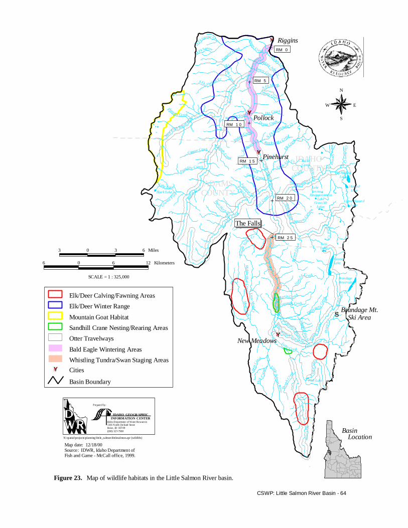
WildlifeWildlife habitats located in the LittleSalmon River basin are shown on Figure 23.These habitats have been identified instudies by various government agencies andobservations of the residents and visitors tothe basin.
Big GameMost of the large game mammal populationsin the Little Salmon River basin, includingmule deer, elk, black bear, and mountainlion, are stable or expanding (Rohlman1998). After dramatically increasing innumber in the late 1980s, mule deer arerecovering from a harsh 1992-1993 winter.Elk were introduced from YellowstoneNational Park to the New Meadows area inthe 1930s. Elk populations remainedsuppressed until the 1970s when regulationschanged to permit only bulls to be harvested.Whitetail deer populations are either stableor increasing (Kinner 1998). According toIdaho Department of Fish and Game, primeelk habitat has been eliminated bydevelopment and sloughing of hillsides(from roading) into the stream near Pollock,resulting in the displacement ofapproximately 300 elk.
#Y
#Y
#Y
#Y
#S
IDAHOCOUNTY
ADAMSCOUNTY
N Fk S
quaw Cr
S Fk Squaw
Pap
oose
Creek
Squaw Cr e ek
H
ailey Creek
Captain John Cr
Emery Creek
L it tl
e Sa
lmo n
R
iver
N Fk Sheep
Sheep Creek
Shingle CreekS Fk S hingle Cr
Rapi
d R i
ver
Ranyhan Gulch Hat Creek
Denny Creek
Hans on Creek
We st Fork Rap id R
iver
Indian Cree k
N Fk Rattles
nake Cr
Ratt lesnake Creek
Lockwo od
Cr
Elk C
reek
Fall CreekCamp Creek
Castle C
reekCopper Creek
Paradise Cree k
L ittle Salmo n R
iv er
Rapid Rive r
L it tle E
lk C r
Hya
t t Creek
BuckCreekJack s C
r
Hazard C r
Trai l
Creek
S
quirrel Cr
Pony CrBu l l Horn Cr
Hard C
reek
B oulde r C
re ek
Bascu m Can
yon
LakeSerens
DisappointmentLake
Grass MtLakes
Big HazardLake
HazardLake
Upper HazardLake
Warm
S prings C
r
Clayburn C
r
B row
n C
reek
Corral Cr
TwinLake
GooseLake
BrundageReservoir
Rou
nd V
alley C
r
Mi ddle M
ud Creek
Mud C
reekL ittl e M
ud Cr
Si xm
i l
e Cr eek
Martin Cr eek
Fourmile Creek
Threemi l e Cr
e ek
Brun
dage
Cr
Thor
n C
rWest Branch Goose
E
ast Branch Goo se Cr
Cam
pbel l Di tch G
oo
se
Cre
ek
Little G oose CrLittle Creek
Mil l
Creek
Vick
Cre
e k
Little Salmon Rive r Th
rush
Cre
ek
Big Creek
Fish LakeF
ish
Cre
ek
Black Lake
Lake Fork
G
rani te
F
or
k
Pollock
Pinehurst
New Meadows
RigginsRM 0
RM 5
RM 1 0
RM 1 5
RM 2 0
RM 2 5
The Falls
Brundage Mt.Ski Area
Whistling Tundra/Swan Staging Areas
Bald Eagle Wintering Areas
Otter Travelways
Elk/Deer Calving/Fawning Areas
Elk/Deer Winter Range
Mountain Goat Habitat
Sandhill Crane Nesting/Rearing Areas
Basin Boundary
#Y Cities
BasinLocation
Prepared by:
IDAHO GEOGRAPHICINFORMATION CENTER
Idaho D epartmen t of Water Resources1301 N orth Orchard StreetBoise, ID 83709(208) 327-7900
X:\spatial\projects\planning\little_salmon\littlesalmon.apr (wildlife)
SCALE = 1 : 325,000
3 0 3 6 Miles
6 0 6 12 Kilometers
N
EW
S
Map date: 12/18/00Source: IDWR, Idaho Department ofFish and Game - McCall office, 1999.
CSWP: Little Salmon River Basin - 64
Map of wildlife habitats in the Little Salmon River basin.Figure 23.
CSWP: Little Salmon River Basin - 65
Birds and Mammals Listed Under theEndangered Species Act
Bald Eagle (Haliaeetus leucocephalus)Bald Eagles are currently listed asthreatened. Originally listed as endangeredon March 11, 1967, they were downlisted tothreatened on July 12, 1995. On July 6,1999, the U.S. Fish and Wildlife Serviceproposed delisting the bald eagle becauseavailable data suggests that the species hasrecovered to population levels necessary tomaintain a viable population (U.S. Fish andWildlife Service 2000b).
Bald eagles have wintered along the LittleSalmon River, but U.S. Forest Servicesurveys have not yielded any wintering birdson the Little Salmon River since 1993 (Bonn1998). No summer nesting locations havebeen recorded in the basin (Rohlman 1998).
Canada Lynx (Lynx canadensis)This species is listed as threatened, effectiveApril 24, 2000. The U.S. Forest Service iscurrently in consultation with the U.S. Fishand Wildlife Service about the possibleeffects on the Canada Lynx of the GooseCreek Watershed Projects (Brandel 2000).
Gray Wolf (Canis lupus)The Idaho population of gray wolves waslisted on November 22, 1994, is an“Experimental Population – non-essential.”On July 13, 2000, the U.S. Fish and Wildlifepublished a proposal to reclassifypopulations of gray wolf. Under this change,Idaho’s population would retainExperimental Population designation, andwould be a part of the Western DistinctPopulation Segment, subject to rules specificto that Distinct Population Segment.Comments on this proposal are due byNovember 13, 2000 (U.S. Fish and WildlifeService 2000b).
Since being introduced into Idaho’sbackcountry, the gray wolf makes infrequentvisits to the Little Salmon River basin. Thespecies is not a resident, and the basin is not
in the proposed wolf recovery area(Rohlman 1998).
Northern Idaho Ground Squirrel(Spermophilus brunneus brunneus)Found only in Adams and Valley counties,Idaho, this animal was listed as threatenedeffective May 5, 2000. Remainingpopulations are threatened by the invasion ofconifers into meadows. Fire suppression,recreational hunting, land development, anddense regrowth of conifers after logging hassignificantly reduced ground squirrel habitatover the last forty years, and has reducedtravelways and created isolated populations(U.S. Fish and Wildlife Service 2000b).
Additional Sensitive SpeciesThe Little Salmon River basin is home tomany species not on the U.S. Fish andWildlife Service threatened or endangeredlist, but whose populations may be at risk.These species include:
• Mammals: fisher, wolverine, andTownsend’s big-eared bat
• Birds: pygmy nuthatch, northerngoshawk, great gray owl, black-backedwoodpecker, white-headed woodpecker,three-toed woodpecker, Lewiswoodpecker, mountain quail,flammulated owl
• Amphibians: Columbia spotted frog,giant salamander
• Fish: westslope cutthroat trout, Pacificlamprey, redband trout
• Invertebrates: Columbia pebblesnail
• Plants: puzzling halimolobos, Borsch’sstonecrop, rock stonecrop, shortfacelanx, small northern bog-orchid, swamponion, Hazel’s prickly phlox, Idahosubalpine maidenhair fern, Lyall’sphacelia, green-band mariposa lily,broad-fruit mariposa lily
Little is known about the distribution andabundance of most of these species in thebasin. However, it is known that the white-headed woodpecker, flammulated owl, and

CSWP: Little Salmon River Basin - 66
northern goshawk numbers are declining inthe basin due to the loss of the largeponderosa pine trees and their associatedecosystems (Rohlman 1998).
4.4.2 RecreationFederal, state, and local entities managelands and facilities that provide recreationopportunities in the Little Salmon Riverbasin. Based on land area, the primaryrecreation provider is the U.S. ForestService. The Idaho Department of Fish andGame is the next largest provider, followedby the U.S. Bureau of Land Management,Adams County, and some privateenterprises. It is difficult to quantify totalrecreation use because of the differentmeasurement methods used by differentorganizations. There is also considerabledispersed use (use outside developedfacilities).
Many debates have been given lately tomaking economic comparisons betweenlogging, mining, ranching, recreational-based employment, and inputs to the localeconomy. However, a lack of informationprecludes any conclusive observations frombeing made in this plan. Nevertheless, somestudies warrant mention and are foundbelow. In general, and extrapolating from astudy published last year for Valley County,Idaho (a county adjacent to the LittleSalmon River basin with some similarities),four recreation jobs are worth one sawmilljob in terms of economic impact on acommunity (Guaderama et al. 2000).
FishingThe Little Salmon River basin offers adiverse combination of anglingopportunities. Chinook and steelheadfishing, available on only a few waterwaysin the state, are both available in this basin.Only 16 lakes or reservoirs are managed fortrophy or quality trout in Idaho and two ofthem are located in the Little Salmon Riverbasin: Brundage Reservoir and Lake Serene.
Studies have been conducted that directly orindirectly measure how much value iscreated by steelhead and salmon fishing inand surrounding the Little Salmon River
basin. Appendix G presents these studies aswell as estimated economic values for othersectors in the basin (see Table G-1).
Chinook SalmonThe Rapid River supplies major tribalceremonial and subsistence opportunities forchinook salmon for members of the NezPerce Tribe. In addition, chinook salmonsport fishing occurs in the spring and earlysummer. The fishing season usually beginsin May, and had been open through July.Angler effort is greatest on weekends,comprising about 50% of the season anglereffort between 1986 and 1997.
Spring chinook salmon returning to theRapid River hatchery provide sport fishingopportunities on the Little Salmon River.From 1978 to 1990, the area provided theonly opportunity to harvest chinook salmonin Idaho (Hassemer 1991). Returninghatchery chinook were not adequate to allowsport angling in 1989, 1991, or 1994 through1996. Fishing in May 2001 has proven to beone of the best years on record for sportfisherman.
The Idaho Department of Fish and Gametracks chinook angling activity in the basin.The number of angler hours as well as thelength of the season and open reaches havevaried over the years. Length of season aswell as angler hours must be consideredwhen attempting to discern trends. Mostyears have experienced an increase in anglerhours since 1986, with 1998 having thehighest increase (78%).
Steelhead and TroutSteelhead fishing on the Little Salmon Riveris unique because no specialized equipmentis necessary. The small size of the river andeasy access via U.S. Highway 95 allow forbank fishing, unlike steelhead fishing on theClearwater or Snake rivers, where motorizedboats are required (Anderson, B. 1998).
The Rapid River, a large tributary in thelower basin, is managed as a wild troutfishery with a two fish limit. Anglingpressure is minimal (Lowell 1999). TheRapid River is the only tributary in the
CSWP: Little Salmon River Basin - 67
Salmon River basin open during steelheadseason (Idaho Department of Fish and Game1996). The season has fall and spring runswith most angling activity occurring in thefall. According to the Idaho Department ofFish and Game, angler hours increasedabout 34 percent between 1992 and 1998.
Lake FishingWith 42 alpine lakes, lake fishingopportunities are abundant in the LittleSalmon River basin. Brundage Reservoir ismanaged for quality rainbow trout fishingexperiences. Fish Lake contains abroodstock of westslope cutthroat trout, andis a major source of eggs for the state(Anderson, D. 1998). Many of the otherlakes are stocked with westslope cutthroat.Lake Serene is a trophy fishery. Goose andHazard lakes receive the most use(Anderson, B. 1998).
BoatingRiver boating in the Little Salmon Riverbasin is generally limited to the spring whenadequate flows are available. Table 7 listsriver and stream reaches where float boatingoccurs. No estimates of boating activity areavailable, but boating activity is increasing,particularly with kayakers (Grussing 1999).
Boating on lakes and reservoirs in the basinis generally associated with fishing. HazardLake allows only non-motorized boating.Although the Little Salmon River basin isonly a part of the two counties, Adams andIdaho counties contain 4.5 percent of theboatable surface acres in the state (Murphy1996). Approximately 1.6 percent ofregistered boaters identified Adams or Idahocounty as their primary use area (Hiatt1999). Boater registration increased about24 percent in Adams County between 1988and 1998, and remained level in IdahoCounty for the same period.
Rapid River Wild and Scenic RiverThe Rapid River is a tributary of the LittleSalmon River located in the lower basin.The portion of the Rapid River that runsthrough public land was designated as aWild and Scenic River as a part of thelegislation (Public Law § 94-1990) thatcreated the Hells Canyon NationalRecreation Area in 1975. The designation isto preserve the river’s remarkable waterquality values. Most of the watershed ismanaged as a roadless area providingprimitive non-motorized recreationopportunities.
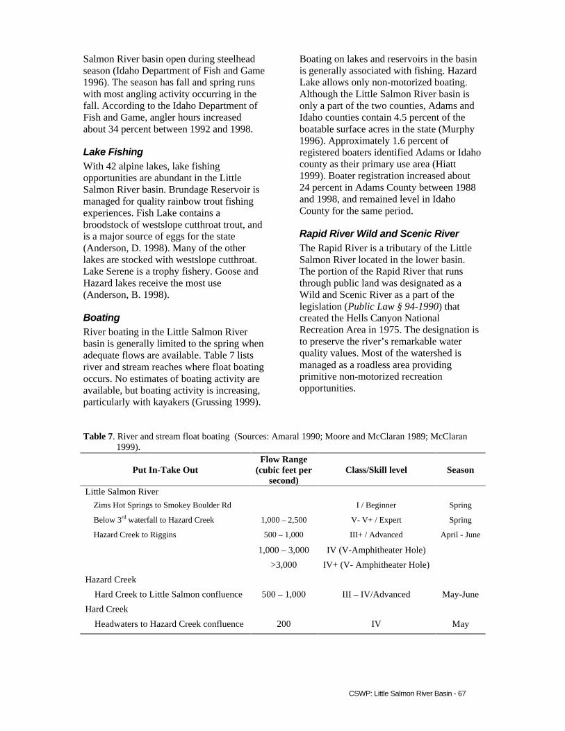
Table 7. River and stream float boating (Sources: Amaral 1990; Moore and McClaran 1989; McClaran1999).
Put In-Take OutFlow Range
(cubic feet persecond)
Class/Skill level Season
Little Salmon River Zims Hot Springs to Smokey Boulder Rd I / Beginner Spring
Below 3rd waterfall to Hazard Creek 1,000 – 2,500 V- V+ / Expert Spring
Hazard Creek to Riggins 500 – 1,000 III+ / Advanced April - June
1,000 – 3,000 IV (V-Amphitheater Hole)
>3,000 IV+ (V- Amphitheater Hole)
Hazard Creek
Hard Creek to Little Salmon confluence 500 – 1,000 III – IV/Advanced May-June
Hard Creek
Headwaters to Hazard Creek confluence 200 IV May

CSWP: Little Salmon River Basin - 68
The area attracts recreationists regionallyfrom Idaho and Washington states. The trailparalleling the Rapid River is one of threeaccess sites into the Hells Canyon NationalRecreation Area. Trail use has a longseason, usually from late March toThanksgiving. Spring arrives in the lowerLittle Salmon River basin in March,allowing early hiking access. Use drops offas the summer heatintensifies, then picks upagain in the fall. The trail receives high useby hunters from mid-October to mid-December. Approximately 90 percent of thehunters access the area by horseback. Alarge number of non-resident hunters use thearea, predominately from Washington. Useis intermittent with the majority of useoccurring around weekends (Anderson, B.1998; Lowell 1999).
The Idaho Department of Fish and Gamemanages a fish hatchery on the lower RapidRiver (outside of the national forestboundary) for the Idaho Power Company.Visitation is estimated at 5,000 to 10,000visits a year. Visitation is highest duringtrapping activities from mid-June to earlyJuly, and spawning times in late August toearly September (Lowell 1999).
HuntingThe Little Salmon River basin is located inthe Idaho Department of Fish and Game’sHunting Unit 23. The department estimatesthat deer hunter effort has doubled between1994 and 1998. Elk hunter days have growneach year, increasing about 69 percent overthe same five-year period. Success rates(total number of elk or deer harvested/totalnumber of hunters) have ranged from 16percent to 25 percent over this same period.Nonresident hunters made up about 13percent of deer hunters and 18 percent of elkhunters in Hunting Unit 23 in 1995 (Kuck1995).
Recreational Dredge MiningRecreational dredges are those with nozzlediameters of five inches or less, andequipment rated at 15 horsepower or less(Idaho Code § 42-3803(a)).
The entire Little Salmon River basin isclosed to recreational dredging under theone-stop permit. Individuals can apply for aStream Channel Alteration Permit from theIDWR for stream reaches not designated asstate protected rivers within the basin.However, the IDWR has indicated thatapplications will not be reviewed until theapplicant has received an incidental takepermit or other approval from the NationalMarine Fisheries Service or the U.S. Fishand Wildlife Service (IDWR 2000b).
CampingThe majority of campgrounds in the LittleSalmon River basin are adjacent or in closeproximity to waterways (Figure 24). Themajority of campsites are operated by theU.S. Forest Service, with one site managedby Adams County. Dispersed camping(areas lacking facilities or services) occursthroughout the basin on public lands.
Winter SportsThe Little Salmon River basin offers anumber of winter activity opportunities fromsnowshoeing to snowmobiling. There aretwo developed ski areas, both of which offera variety of types of snow skiing. The largerof the two, Brundage Mountain, reportedapproximately 100,778 skier visits duringthe 1997-1998 ski season (Naylor 1999), upfrom 97,328 estimated visitors during the1994-1995 season. The U.S. Forest Servicehas constructed a new parking lot forsnowmobiles in the Goose Creek drainage inthe southeastern portion of the basin, on theside of Brundage Mountain. This parking loteases access to Snowmobile Area 43A(Goose, Hard, and Hazard Creek drainages).
4.4.3 TimberAs of the writing of this plan, only one sawmill still existed in the region, but it lies justoutside of the Little Salmon River basin nearits southwest boundary, at Tamarack. A millowned by the Boise Cascade Corporation inCascade, just to the south of the basin,closed in May 2001. Because logging andmanufacturing of wood products haveprovided one of the primary economic

#Y
#Y
#Y
#Y
ÆQ
ÆQ
ÆQNN
NNN
N
N
NNN
N
N NN
N
NN
ÆQN
NNN
NN
N
N
NN
NN
N
N
ò
N
NÆQÆQ
ÆQJJ
ïJ
ò ÆQîÆQ
NN
JJîJîîJ N
î
N
î
îÆQ$
ò
ò
ÆQ$
b
b
bb
bb
b
b
#S
Littl
e Sa l
mon
R
iver
Rapi
d R
iver
Wes
t Fork Rapid R
iver
Little Sa lmon R
iver
R ap
id Riv e r
Hazard Cr
Hard Creek
Boul
de r Cr eek
LakeSerens
DisappointmentLake
Grass MtLakes
Big HazardLake
HazardLake
Upper HazardLake
TwinLake
GooseLake
BrundageReservoir
Mud C
r ee k
Wes t Branch Goose
E
ast Branch Goose Cr G
oo
se C
ree k
Little Salmon River
Big Creek
Fish Lake
Black Lake
IDAHOCOUNTY
ADAMSCOUNTY (/95
(/55Little
Ski Hill
Pollock
Pinehurst
New Meadows
RigginsRM 0
RM 5
RM 1 0
RM 1 5
RM 2 0
RM 2 5
Brundage Mt.Ski Area
Major Roads
Ski Area
Basin Boundary
#Y Cities
Rapid River Wild & Scenic RiverHells Canyon National Recreation Area
ÆQ Campground
b Lookout/overlook
ò Point of Interest
N Trailhead
î Boat Accessï Day Use
$ Hot Spring
J Sportsman Access Area
BasinLocation
Prepared by:
IDAHO GEOGRAPHICINFORMATION CENTER
Idaho Department of Water Resources1301 North Orchard StreetBo ise, ID 83709(208) 327-7900
X:\spatial\projects\planning\little_salmon\littlesalmon.apr (recreation)
SCALE = 1 : 325,000
3 0 3 6 Miles
6 0 6 12 Kilometers
Rapid RiverWild & Scenic River
Hells Canyon NationalRecreation Area
Map date: 12/18/00Source: IDWR, National Forests, BLM, 1999.
PapooseCave
Rapid RiverFish Hatchery
GooseCr. Falls
Brundage Mtn. HandicapFishing Access
CSWP: Little Salmon River Basin - 69
Map of recreation-related facilities or special features in the Little Salmon River basin.Figure 24.
N
EW
S
CSWP: Little Salmon River Basin - 70
foundations to the Little Salmon Riverbasin, mill closures will force logging-jobreductions and related satellite industry lay-offs. Disagreements between local residentsand federal officials over forest firesuppression policies and logging access hasfurther worried the residents in the LittleSalmon River basin.
Commercial logging has occurred in thebasin since the railroad lines were built inthe early part of the 20th century. Theheaviest logging occurred from the 1920sthrough the 1940s. Nearly all the marketabletimber was logged during that period(Kwader 1999).
Several small mills existed in the basin, andBoise Payette Lumber Company(subsequently Boise Cascade) moved toNew Meadows in 1940 (New Meadows1995). The logs or lumber were shipped byrail mainly to Emmett, via Council andPayette, with a smaller volume going toCascade. In the 1930s, cat skidding andtruck hauling became common for movingto the railroad, but most tracks in the basinhad been removed by 1946. With most ofthe easily accessible merchantable timberremoved, lumbering was done by individualcontractors, who preferred to haul by truck,eliminating the industry’s reliance on rail.Harvesting on federal lands today reliesincreasingly on methods such as cable,skyline, and helicopter. This is notnecessarily true on private lands.
The Lower Little Salmon River BiologicalAssessment analysis area, which includedthe drainages of the lower Little SalmonRiver, Rapid River, and Squaw Creek,covers 43,653 acres of Nez Perce NationalForest land (Russell and King 1995). Timberharvests were conducted on 2,569 of theseacres between 1971-1994. Since 1994, therehas been very little logging activity in theNez Perce National Forest (Paradiso 1999).Between 1994 and 1998, the PayetteNational Forest conducted sales and loggedeight tracts on public lands in the basin,which sold for about $1.5 million. They areanticipating more sales as noted in Table 8.
The Idaho Department of Lands isresponsible for approximately 13,410 acresof mixed timber and rangeland in the basin.About 7,500 of those acres are commercialforests; best described as mixed coniferousforest (Keafer 2001). See Table 9 andAppendix G for more details.
Of Boise Cascade’s 48,000 acres in thebasin, 45,000 acres are suitable for harvest,and have been logged up to three times(Appendix G). The company still conductscommercial thinning activities in the basin(Kwader 1999). For more information ontimber, refer to Appendix G.
4.4.4 MiningThe majority of past mining activity in theLittle Salmon River basin was in the SevenDevils Mountains and Hells CanyonNational Recreation Area. Historically,surface mines were found sprinkledthroughout the Little Salmon River basin(Nichols 2000). There are some talc depositsin the New Meadows area, located onprivate property, and one known inactivetalc mine near the Rapid River. There arecopper deposits in the Seven DevilsMountains, and gold was taken out of RapidRiver. Rocky Flat, now a housingsubdivision near Little Ski Hill in thesoutheast portion of the basin, was the sightof a placer mining operation. That activitycame to a halt by the 1930s (Gillerman2000).
There is very little current mining activity inthe Little Salmon River basin. However,there are several sand and gravel operationsnear Pollock (Nichols 2000), and there is anactive gemstone placer operation on atributary to Little Goose Creek, located inthe southeast portion of the basin (Gillerman2000).
Mineral potential in the basin is primarily inthe Rapid River drainage, but that potentialis low relative to the rest of the state. Thereare a number of patented claims in the RapidRiver-Hells Canyon complex. The SevenDevils area’s mining potential is limited bythe protection associated with its inclusion

CSWP: Little Salmon River Basin - 71
Table 8. Payette National Forest timber sales (Source: Alexander 1999 and Demetriades 2001).
Year Sale Name Total Volume(mbf)1 Total Value ($)
1994 Brundage Parking Lot Extension 111 50,4271994 Brundage ROW 116 47,6001995 Big Doug Salvage 54 4,0021996 Thorne 21 Salvage 1,543 508,0041996 The Haz Salvage 4,109 39,6591996 Twin Duck Salvage 2,125 90,4731996 Cooked Goose Salvage 547 38,9741998 Four Mile 4,409 770,0001999 Brown’s Creek 2,400 130,5442001 Bare Rock (Goose Creek) 7,500 1,125,0002000 Second Chance (Goose II) 4,600 541,4532002 Lockwood 10,000 2
2003 Partridge-Kelly LA 5,000 2
2004 Boulder Helicopter 10,000 2
Totals 57,014 3,346,1361Million board feet2Not yet determined
Table 9. Idaho Department of Lands timber sales (Source: McManus 1999).
Year Acres Sale Name Volume (MBF)1 Condition1988 980 Little Mud Creek 3,165 Completed
1994 690 Big Creek 3,125 Competed
1997 274 Hailey Shorts 2,980 Completed
1998 380 Bally Mountain 5,000 Active
1998 520 Pinehurting 2,925 Proposed
2000 240 Indian Mountain 3,235 Completed
2002 640 Tepee Springs 2,500 Proposed
2003 1,150 Rattlesnake Creek 4,000 Proposed
Totals 4,874 26,9301Million board feet
in the Hells Canyon National RecreationArea. There has been some limited diamondand other gemstone exploration in thesoutheast portion of the basin, nearBrundage Mountain (Gillerman 2000).
The entire Little Salmon River basin wasclosed to recreational dredge mining. Allproposals for dredge mining must submit a
joint application for permit to the IDWR andthe U.S. Army Corps of Engineers.Applications will not be reviewed unless theapplicant has received an Incidental Takepermit or other approval from the NationalMarine Fisheries Service or the U.S. Fishand Wildlife Service (Idaho Department ofWater Resources 2000b).