ground measurement acquisition report for the valeri site...
TRANSCRIPT

Ground measurement acquisition report for the VALERI site
Alpilles
sampled from 22/07/2002 to 23/07/2002
Sébastien Garrigues Organization: INRA
email: [email protected]
Date of report 15/10/2002
People participating to the field experiment:
Fistname & Name 0rganization
Cédric Bacour Inra, Avignon Roland Bosseno IRD/INRA CSE, Avignon, France Sébastien Garrigues Inra, Avignon Franck Oro Inra, Avignon Eleanor Stevens Marie Weiss Noveltis, Toulouse Nadine Bruguier Inra, Avignon
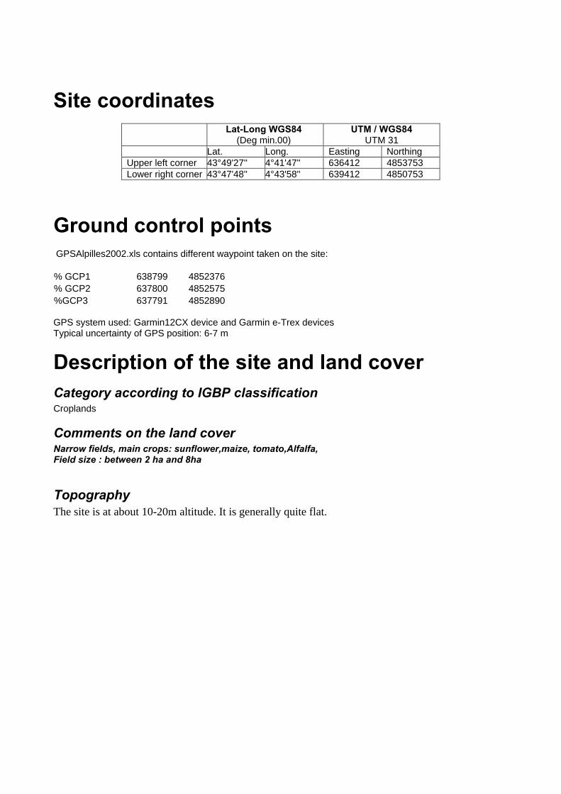
Site coordinates Lat-Long WGS84
(Deg min.00) UTM / WGS84
UTM 31 Lat. Long. Easting Northing Upper left corner 43°49'27'' 4°41'47'' 636412 4853753 Lower right corner 43°47'48'' 4°43'58'' 639412 4850753
Ground control points GPSAlpilles2002.xls contains different waypoint taken on the site: % GCP1 638799 4852376 % GCP2 637800 4852575 %GCP3 637791 4852890 GPS system used: Garmin12CX device and Garmin e-Trex devices Typical uncertainty of GPS position: 6-7 m
Description of the site and land cover Category according to IGBP classification Croplands
Comments on the land cover Narrow fields, main crops: sunflower,maize, tomato,Alfalfa, Field size : between 2 ha and 8ha
Topography The site is at about 10-20m altitude. It is generally quite flat.
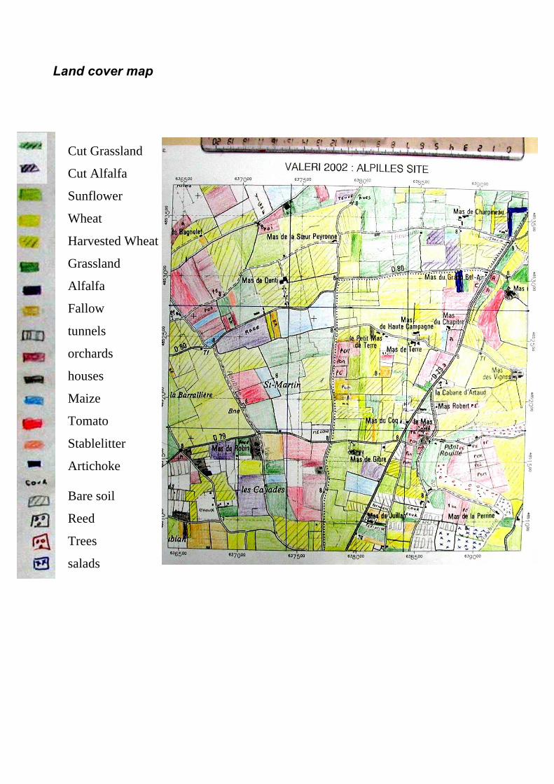
Land cover map
Cut Grassland
Cut Alfalfa
Sunflower
Wheat
Harvested Wheat
Grassland
Alfalfa
Fallow
tunnels
orchards
houses
Maize
Tomato
Stablelitter
Artichoke Bare soil
Reed
Trees
salads
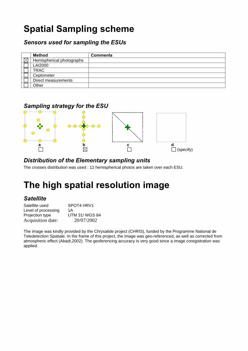
Spatial Sampling scheme Sensors used for sampling the ESUs Method Comments
Hemispherical photographs LAI2000 TRAC Ceptometer Direct measurements Other
Sampling strategy for the ESU
a b c d (specify)
Distribution of the Elementary sampling units The crosses distribution was used : 12 hemispherical photos are taken over each ESU.
The high spatial resolution image Satellite Satellite used SPOT4 HRV1 Level of processing 1A Projection type UTM 31/ WGS 84 Acquisition date: 20/07/2002 The image was kindly provided by the Chrysalide project (CHRIS), funded by the Programme National de Teledetection Spatiale. In the frame of this project, the image was geo-referenced, as well as corrected from atmospheric effect (Abadi,2002). The geoferencing accuracy is very good since a image coregistration was applied.

List of the ESUs The GPSAlpilles2002.xls file contains the information for each ESU: %Name Easting (m) Northing (m) Note % GCP1 638799 4852376 Crossing roads % GCP2 637800 4852575 Crossing roads %GCP3 637791 4852890 Crossing roads ULC 636412 4853753 LRC 639412 4850753 CB01 637993 4852687 Sunflower CB02 637864 4852383 Apple tree orchard, Above and Below acquisitions (understorey), distance between rows = 8m50CB03 637931 4852238 Sunflower CB04 638841 4852760 Tomato CB05 638776 4853212 Alfalfa, Height 40cm, Homogeneous CB06 638604 4853468 Grassland, Homogeneous, different species CB07 638186 4853461 Grassland, Homogeneous, different species CB08 637722 4853026 Harvested wheat, green regrowth, heterogeneous CB09 638045 4852910 Sunflower, same as CB01 CB10 637183 4853195 Sunflower, Height:1.70m CB11 637134 4853447 Harvested Wheat, LAI=0, no photo CB12 636691 4853076 Peach tree orchard, Below photos, Distance between rows = 4m, height = 3mCA01 637658 4852663 Maize CA02 637708 4852489 Grassland, very low and sparse vegetation CA03 637695 4852080 Harvested wheat + green regrowth CA04 637164 4852521 Alfalfa, Heterogeneous CA05 636771 4852223 Harvested wheat + green regrowth CA06 637031 4852111 Tomato CA07 639317 4852633 Sunflower, it stings! CA08 638621 4852359 Tomato CA09 638552 4851799 Harvested wheat + green regrowth CA10 639094 4851554 Apple tree orchard, Above and Below acquisitions (dense green understorey), high hedges around the field, 1 row is missing at the center of the field, CA11 638500 4851363 Harvested wheat + green regrowth CA12 639075 4850895 Salads CA13 637164 4851192 Alfalfa (sparse) CA14 637317 4851225 Grassland CA15 636690 4850916 Fallow CA16 637788 4850925 Sunflower CA17 637668 4851279 Peach tree orchard, Peaches not mature,Hedges at the middle of the field, Above and Below photosCA18 637667 4851566 Tomato
Acknowledgements Many thanks to the farmers who let us walk into their fields (J. GRANGIER, Yvonne CAVALIER, Henriette PALOT, E. ESPIGUE, G. GONTIER, A. MISTRAL, N. CLARION, C. VIVARES, L. GRANGIER, T. CHASSEFIERE…). Thanks also to the Chrysalide project for providing the SPOT image. Thanks to all the people who participated to the field campaign and to the field campaign preparation ( thanks to Nadine and Marie !!)

Photo gallery The photos illustrating the campaign are to be stored in the directory “photo gallery” and the labels should be indicated in the table above. For each ESU a panoramic photo was taken, the photo name is the ESU number # File name Comments 1 CYXX.jpg ESU Panoramic photo for Team Y and photo number XX 2 CHRIS&VALERITeamsatLunch.jpg 3 HappyEnd.jpg 4 HappyWork.jpg 5 HemiTeamAB.jpg 6 HowToUseAcar.jpg 7 MixedTeams.jpg 8 SebIsAnExcellentDriver.jpg 9 TeamsAB.jpg
Additional comments Very friendly campaign