greenways and landscapes - opus.lib.uts.edu.au
TRANSCRIPT
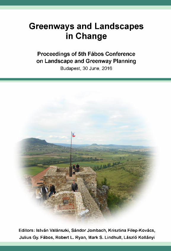
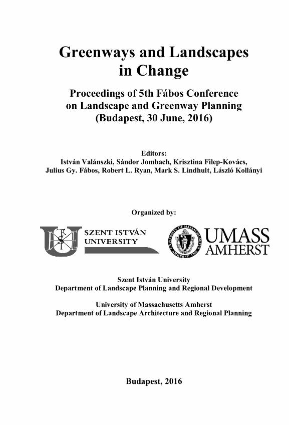
Greenways and Landscapes in Change
Proceedings of 5th Fábos Conference on Landscape and Greenway Planning
(Budapest, 30 June, 2016)
Editors: István Valánszki, Sándor Jombach, Krisztina Filep-Kovács,
Julius Gy. Fábos, Robert L. Ryan, Mark S. Lindhult, László Kollányi
Organized by:
Szent István University Department of Landscape Planning and Regional Development
University of Massachusetts Amherst Department of Landscape Architecture and Regional Planning
Budapest, 2016
This publication should be cited as follows: Valánszki, I., Jombach, S., Filep-Kovács, K., Fábos, J. Gy., Ryan, R. L., Lindhult, M. S., Kollányi, L. (Eds.) 2016: Greenways and Landscapes in Change – Proceedings of 5th Fábos Conference on Landscape and Greenway Planning (Budapest, 30 June, 2016) Editors: István Valánszki, Sándor Jombach, Krisztina Filep-Kovács, Julius Gy. Fábos, Robert L. Ryan, Mark S. Lindhult, László Kollányi Conference Committee: Julius Gy. Fábos, Ph.D., FASLA, Univeristy of Massachusetts Krisztina Filep-Kovács, Ph.D., Szent István University Sándor Jombach, Ph.D., Szent István University László Kollányi C.Sc, Szent István University Mark S. Lindhult, FASLA, Univeristy of Massachusetts Robert L. Ryan, Ph.D., FASLA, Univeristy of Massachusetts István Valánszki, Ph.D., Szent István University Published by: Szent István Egyetem, Tájtervezési és Területfejlesztési Tanszék Szent István University, Department of Landscape Planning and Regional Development, 1118 Budapest Villányi út 39–43, Hungary Printed by Amber Industries Kft. This publication is available on the conference web-site: https://sites.google.com/site/fabos2016/home Sponsors of the conference: Fabos Fund in Landscape Architecture & Regional Planning
Szent István University, Department of Landscape Planning and Regional Development
University of Massachusetts Amherst, Department of Landscape Architecture and Regional Development ISBN 978-963-269-547-1 Editing and page print: István Valánszki, Sándor Jombach Cover design by Sándor Jombach
3
TABLE OF CONTENTS
Plenary 1 9
Gina Ford: Micro, Mega and Macro: Designing Landscapes of Urban Change
11
Session 1: Climate Change and Greenways 19
Rieke Hansen, Anton Stahl Olafsson, Alexander Van der Jagt, Emily Rall, Stephan Pauleit: Planning multifunctional green infrastructure in urban areas – advanced approaches based on case studies from Denmark, Germany and the UK
21
Birgit Gantner, Brigitte Allex, Christiane Brandenburg, Christina Czachs, Doris Damyanovic, Florian Reinwald, Jürgen Preiss: Urban Heat Islands Strategy Plan Vienna – Implementing Urban Green Infrastructure to Reduce Negative Effects of Urban Heat Islands
29
Ingrid Merete Ødegård: Is there an ideal model for effective stormwater management in Norway?
37
David C. Ralston: Climate Action Planning and Urban Greenways: Weaving Together Sustainability, Health and Resilience
45
Melissa Wagner, Lauren E. Gentile, Joanna Merson, Elizabeth Wentz: Sustainable Urban Planning and Climate Change Scenarios: an investigation of Staten Island's urban planning
53
Session 2: Ecosystem Services and Landscape Planning 61
Zhang Wei, Jack Ahern: Novel Urban Waterfront Ecosystem Services Evaluation, Monitoring and Improving Strategies
63
Mina Di Marino: Ecological networks and ecosystem services in urban regions - Implementation and planning practices
71
Klaudia Máté, László Kollányi: The potential impact of greening as a directed land use on the landscape structure
79
Viktória Csizmadiáné Czuppon, Nino Chachava, Gudrun Nahrendorf, Andrea Malerba, Andrea Pizzato: Green for commons: paths of development in Hungary, Germany and Georgia
87
László Kollányi, Klaudia Máté: Connectivity analysis for green infrastructure restoration planning on national level
95
4
Session 3: Open Space Design 103
Jose LaSalle, Ezra Marcus, Josh Nolan, Yamaan Ziade, Brandon Curtin: BioSTEAD Initiative: A Transdisciplinary Initiative to Construct Safe-to-Fail Green Buildings as Sustainable Development Research Sites on University Campuses
105
Maria Ananiadou-Tzimopoulou, Sofia Tzimopoulou, Panagiota Mouratidou: The Agia Sofia’s axis. A corridor of change and resilience for Thessaloniki
113
Heike Tenzer: The Garden Kingdom of Dessau-Wörlitz as an example for the management of a historical monument
121
ZhengWang Wu, Yuting Han: Flexible Space Design of Community Greenways in Temperate Zone of Asia -- Beijing Case Study
131
Fruzsina Zelenák, Attila Szűz, Péter István Balogh, Andrea Dúll, Kinga Szilágyi: A Method for Analyzing Open Space improvements in Urban Environments: A Budapest Case Study
139
Session 4: Heritage, History and Art 147
Dagmar Grimm-Pretner, Ulrike Krippner: Vienna and theDanube Island: Shifting Objectives for an Urban Greenway
149
Charles L. Tracy: Art in Parks: Seeing with Fresh Eyes 157
James C. O’Connell: The Legacy of Frederick Law Olmsted’s Emerald Necklace in Contemporary Boston
165
Simon Kilbane, Jonathan Kopinski: Evolution and Evaluation of Contemporary Greenways and Green Infrastructure in Sydney, Australia
173
Fatemeh Shahani, Julie Rudner: The Role of Culture in Greenway Planning: Focus on Islamic-Persian Garden Characteristics in the UK and the USA
183
Session 5: Rural Landscapes 193
Attila Tóth: Greenways as Linear Components of Green Infrastructure in Rural Agricultural Landscapes of South-Western Slovakia
193
5
Krisztina Filep-Kovács, Ágnes Sallay, Zsuzsanna Mikházi, Sándor Jombach, Zsolt Szilvácsku, István Valánszki, Géza Gelencsér: Green infrastructure in rural development, case study in Hungary
203
Ercan Gökyer, Melih Öztürk: Planning Greenway Alternatives within the Rural Areas of Bartın Province, Turkey
211
Brankica Babec, Srđan Šeremešić, Ljiljana Nikolić, Ksenija Hiel: Designing the network of ecological corridors among organic farms in South Bačka district of Vojvodina Province
221
Session 6: Landscape Ecology and Nature Protection 229
Julie Chaurand, Jean-Philippe Tonneau, Jacques Baudry: The “Trame verte et bleue” French policy: what territorial coherence does it offer?
231
Zoltán Horváth, Rita Szeiler, Anouk Cormont, Michiel van Eupen: Designation of potential excavation zones suitable for minig - modelling different types of land uses; MINATURA2020 Hungarian Case Study (Tállya Region)
239
Klara Marijanušić, Saša Orlović, Aleksandar Kurjakov, Lazar Pavlović, Maja Manojlović: Greenways in landscape planning – case study: Municipality of Subotica
247
Beata Fornal-Pieniak, Maciej Żołnierczuk, Ewa Zaraś-Januszkiewicz: Ecological structure of Nasielsk commune in Poland
255
Jadwiga Środulska-Wielgus, Krzysztof Wielgus, Olga Maj: Cultural tourism trails as part of sustainable tourism – the tool of shaping the greenways and protection of ecosystems in Gorce
263
Plenary 2 271
Charles A. Flink: Greenways As Resilient Global Landscape Solutions
273
Session 7: "Greenspace" Design and Art 285
Eric Firley, Frank Sleegers: The landscape in urbanism - a historical view into the future
287
6
Urszula Forczek-Brataniec: The degree of visibility as a tool to assess and design of a visual corridor
295
ZhengWang Wu, Yanhui Wang: Design Strategy of Community Greenway Connectivity of High-density Urban Asia – A Case Study on Beijing
303
Deni Ruggeri: Landscape infrastructure and the retrofitting of sustainability into suburban communities: Irvine, California’s Jeffrey Open Space Trail
311
Hongbing Tang: Pressing Challenges in China’s Greenway Planning and Design: Promoting or Diminishing Cultural Identities and Values?
321
Session 8: Cultural Landscapes 331
Albert Fekete, Martin van den Toorn: The Maros river and its potential for landscape development
333
Dorota Gawryluk, Maciej Kłopotowski: Bialystok (Poland) -green city. Historical greenways in a contemporary city
343
Susanne Gerstberger: Lp(R)evolution: A City on the Way to the Future. Las Palmas: ParkCity
351
Nedim Kemer: Historic Roads of Asia Minor and Greenway Potential for Ankara
359
Session 9: Urban Agriculture and Horticulture 369
Matt Hisle, Frank Sleegers: Utilizing Phytotechnologies: Redesigning Abandoned Gas Stations
371
Magdalena Błaszczyk, Marzena Suchocka: The tree valuation method as a tool for supporting greenway planning and development. Case study: section of Central Highway in Gliwice, Poland
379
Marzena Suchocka, Henryk Kociel: Structural soil in dense city areas - functions and chances for urban greenways development
387
Krisztina Szabó: The potential roles of biodiverse green roofs in the extending urban green network
397
7
Session 10: Urban Green Infrastructure 407
Fan Fu, Guangsi Lin, Bo Zhang: Greenway: The Backbone of Sponge City in China
409
Pedro Calaza-Martínez: Green infrastructure, physical activity and health. Evidence of their relationships in Spain
417
Agnieszka Olszewska, Paulo Marques: Contemplative Greenway Design for the Health and Well-Being of City Inhabitants
425
Ian Fisher, Ann Sharrock: Urban Natural Burial: Re-presenting Data as a Means of Communicating New Approaches to Green Infrastructure
433
Na Xiu, Maria Ignatieva, Cecil Konijnendijk van den Bosch: Planning and Design of Urban Green networks in Stockholm
441
Luke Engleback: Ecourbanism in Rwanda – a whole system approach to city building
449
Session 11: Landscape Theory and Methodology Development 459
Anne A. Gharaibeh, Haneen A. Sawalqah: Greenway Planning; Developing A Network Methodology For Jordan
461
Ildikó Réka Báthoryné Nagy, Katalin Takács: Evaluation methods of urban trees along the Danube in Budapest
471
Haiyun Xu, Tobias Plieninger, Jørgen Primdahl: A systematic review of landscape corridor conservation and management in Europe
479
Christian Küpfer, Sascha Arnold: Avoid – mitigate – compensate: Halting the loss of biodiversity in landscapes “under pressure” - Landscape Planning and Eco Account examples from the Stuttgart region, Germany
487
Martin van den Toorn, Albert Fekete: Greenway planning and landscape structure; some theoretical backgrounds
495
Claudia Stoll: Improving Urban Greenways Using James Rose’s Theories of Integration
505
8
Session 12: Tourism, Public Participation and Landscape 513
János Csapó, Géza Szabó, Zoltán Horváth, Réka Pintér: A new step in greenway planning and practice – the challenges of branding a cross-border greenway in Hungary
515
Kristin Faurest, Deni Ruggeri: Landscape Education for Democracy: A Proposal for Building Inclusive Processes into Spatial Planning Education
523
Beáta Stefanics: Developing opportunities of bicycle tourism between Budapest and Lake Balaton
531
Zoltán Zakota, Tamás Z. Zakota: On the Possibility of Extending the European Green Belt to the Hungarian-Romanian Border Region
539
Chingwen Cheng, Mohsen Garshasby: Resilient Greenway: A Participatory Planning Framework
547
Heritage, History and Art
173
Evolution and Evaluation of Contemporary Greenways and Green Infrastructure in Sydney, Australia
Simon Kilbane1, Jonathan Kopinski2 1University of Technology Sydney, Sydney, Australia
2University of Queensland, Brisbane, Australia
Introduction
Greenways are as diverse in their contemporary forms as the geographical regions they sample. Within an Australian urban context this paper will outline how greenways have added to their culturally focussed intentions of recreation and active transport (Little, 1995; Walmsley, 1995) and could now be described as ‘green infrastructure’. Described by Benedict & McMahon (2006) as essential and life-supporting, Australian green infrastructure follows Europe’s lead (Jongman, Külvik, & Kristiansen, 2004) expanding the greenway remit to include vital hydrological functions (Ahern, 2007), the provision of valuable ecosystem services (Millennium Ecosystem Assessment, 2005) and a range of essential ecological benefits for urban regions across multiple scales. This paper begins by reviewing Sydney’s open space and greenway history, policy and planning and culminates with a detailed study of its most recent greenway proposal, the Sydney Green Grid (Schaffer, 2015). As a multi-functional green infrastructure this city-wide framework aims to create a strategic open space network; to reinforce sense of place between citizens and landscape; and to promote multifunctional environmental, health, social and economic benefits. A series of drawings then explored one strand of this network, the Mountains to the Sea greenway where the shift from large (city) to small (neighbourhood) scale was explored in detail, revealing a potential green infrastructure that offered a spectrum of critical ecological, hydrological, cultural and transportation benefits. However, it also revealed the existing complexities in implementing such a scheme in the contemporary city. This paper argues that it is both timely and relevant that greenways be considered and reframed as essential ‘green infrastructure’, however that such networks must also be interrogated through mapping and design methods such as those demonstrated herein in order to facilitate their implementation and adoption.
Background
Sydney’s most recent metropolitan-scale greenway proposal, The Sydney Green Grid (SGG), has its origins in a sequence of historical events, key open space planning, greenway and green infrastructure projects that have shaped the city’s form and character over the last 70 years.
Session 4
174
In the years directly following the Second World War, Sydney quickly grew to house nearly a quarter of Australia’s entire population (Winston, 1957). This growth led New South Wales Premier William McKell to introduce an additional tier of government, the Cumberland County Council, positioned between the local and state level in order to address urban issues and to guide holistic metropolitan planning strategy. Released in 1948, the post-war County of Cumberland Planning Scheme as a progressive and comprehensive planning model prioritised landscape as a means to organise the city (Dictonary of Sydney Staff Writer, 2008). As a statutory body, the Council was charged with overseeing the coordination, consolidation and conservation of Sydney’s metropolitan form against the opportunistic privatised housing development occurring along the city’s periphery. To counter the corresponding infrastructure expenditure to service these green-field locations (Winston, 1957) the Cumberland Plan proposed a system of land-use zoning, suburban employment precincts and open space acquisitions, together with the implementation of a city-scale green belt that further aimed to limit further peripheral sprawl (Ashton & Freestone, 2008). The council also sought to establish a unified open space system ‘The Green Web’. This comprised ‘green lungs’ or ‘breathing spaces’ as a network of greenways to link existing tracts of landscape and waterways, establishing landscape buffers between differential land zones. Within the web a range of social infrastructures including walking tracks, playgrounds, parks, sports fields, nature reserves and scenic areas were programmed connecting the city’s centre to its edge (Winston, 1957). The Cumberland Plan was strongly opposed throughout the Council’s 12 years and when the critical federal funding – deemed critical for the resumption of lands to link the green belt – was removed, its realisation stalled (Dictonary of Sydney Staff Writer, 2008). Replaced by the non-statutory Sydney Regional Outline Plan Sydney abandoned the green belt and web shifting towards singular landscape projects that nevertheless illustrate the potential of a greater system.
With the 1960s and 1970s heralding the introduction of ecology and sustainability into broader consciousness (Bull, 1996), the practice of landscape architecture in Australia began to serve as a kind of ‘ecological infrastructure’ that could critically reconstruct – or remediate the city – one project at a time. Two key greenway projects benchmark this shift. First, Sir Joseph Banks Reserve, designed and constructed between the late 1970s and early 1980s, is a 28ha linear parkland commissioned as part of the relocation of Sydney’s port from to Botany Bay. Mediating a particularly problematic wedge of residual territory squeezed between the port’s new freight roadway and residential surroundings, Mackenzie reconnected the community and foreshore through sculpting the site into an undulating landmass of sand dunes
Heritage, History and Art
175
and lagoons. These served to both reduce traffic noise and to provide a substrate for a constructed ecology of plant species once endemic to the area (MacKenzie, 2011). Importantly, this project illustrates the potential of the greenway as a typological model, ably mediating the often-competing interest of government, development, community and ecology. A decade later the Restoring the Waters Project, designed by Schaffer Barnsley Landscape Architects (1999), focused on the landscape restoration of a degraded water corridor. An early precursor to the Water Sensitive Urban Design (WSUD) projects now commonplace in Australia, engagement with a diverse range of interest groups, stimulated a revenue stream for the project, essential for a suite of recreational, ecological and social benefits, in addition to WSUD aims.
The use of the landscape project as a device for ecological infrastructure ultimately coalesced in the designed remediation of the degraded Homebush Bay site for Sydney’s ‘Green Olympic Games’ in 2000 (Tyrrell, 2011). Here, principles tested in the aforementioned projects were super-sized on a scale never seen before in Australia, resulting in the total reclamation of 50 hectares of contaminated post-industrial wetland corridor (Lynch, 2000). As the key feature of the Olympic landscape, it was the greenway as a multi-scalar and infrastructural typology that became one of the principal design drivers behind many subsequent revitalisation projects in the inner city. This is particularly evident in the Green Square Public Domain Strategy (McGregor Coxall) and The Goods Line (Aspect Studios) which represent a catalytic shift in the approach to urban densification. Green Square, set within one of Sydney’s largest ever urban renewal developments inverted the typical redevelopment staging model by prioritising the design and delivery of the public domain (MacGowan, 2008). Envisaged as a piece of ‘ecological machinery’, the project condensed the hydrological services of greenway design into a compact network of hydrological infrastructure to which future development could connect. This proposed the daylighting of an underlying drainage stream that had once flowed through the site as restored water corridor and proposed a new, ecologically-active civic heart for surrounding development (MacGowan, 2008). The recently completed Goods Line, linking Sydney’s famed Darling Harbour with the rest of the city, connects a range of neighbouring institutions by reconfiguring a disused railway corridor as linear greenway park. This has increased pedestrian traffic and recreational use and incentivised commercial revitalisation while acknowledging the historical fabric of the site and providing a variety of visitor spaces and experiences.
With the ability of such projects to integrate social, ecological and economic benefits, the NSW State Government’s Architect’s Office developed a wider plan to advocate and choreograph future projects across Sydney, the Sydney
Session 4
176
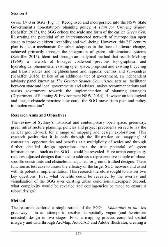
Green Grid or SGG (Fig. 1). Recognised and incorporated into the NSW State Government’s non-statutory planning policy, A Plan for Growing Sydney (Schaffer, 2015), the SGG echoes the scale and form of the earlier Green Web, illustrating the potential of an interconnected network of metropolitan open space to improve citizen liveability and well-being. However, this 21st century plan is also a mechanism for urban adaption in the face of climate change, achieved primarily through the integration of green infrastructure systems (Schaffer, 2015). Identified through an analytical method that recalls McHarg (1969), a network of linkages coalesced previous topographical and hydrological phenomena, existing open space, proposed and existing bicycling and transit routes and neighbourhood and regional centres and sub-centres (Schaffer, 2015). In lieu of an additional tier of government, an independent advisory panel known as The Greater Sydney Commission acts as facilitator between state and local governments and advises, makes recommendations and assists government towards the implementation of planning strategies (Department of Planning & Environment NSW, 2014). However an ideological and design obstacle remains: how could the SGG move from plan and policy to implementation?
Research Aims and Objectives
The review of Sydney’s historical and contemporary open space, greenway, green infrastructure planning, policies and project precedents served to lay the critical ground-work for a range of mapping and design explorations. This research posits that it is only through the illustration or ‘mapping’ of constraints, opportunities and benefits at a multiplicity of scales and through further detailed design operations that the true potential of green infrastructures – such as the SGG – could be revealed. Here urban complexity requires adjusted designs that need to address a representative sample of place-specific constraints and obstacles as adjusted, or ground-truthed designs. These function as test case to assess the efficacy of the larger SGG network and assist with its potential implementation. This research therefore sought to answer two key questions. First, what benefits could be revealed by the overlay and visualisation of the SGG over existing urban condition/landscapes? Second, what complexity would be revealed and contingencies be made to ensure a robust design?
Method
The research explored a single strand of the SGG – Mountains to the Sea greenway – in an attempt to resolve its spatially vague (and heretofore untested) design in two stages. First, a mapping process compiled spatial imagery and data through ArcMap, AutoCAD and Adobe Illustrator, creating a

Heritage, History and Art
177
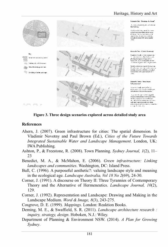
suite of high quality maps to accurately illustrate and highlight both the SGG’s spatial influence and to reveal potential conflicts. Second, three potential greenway design ‘scenarios’ were explored: ‘Business-as-usual’; the ‘Classic Greenway’; and ‘True Green Infrastructure’. These documented a range of design possibilities from minimal impact, low cost to significant, high cost options as spatially accurate and visual illustrations.
Results
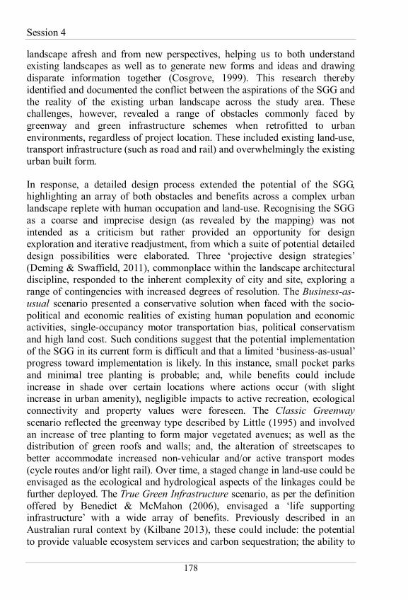
The overlay of the selected Mountains to the Sea Greenway over the urban landscape of Sydney’s Eastern suburbs revealed several findings, illustrated as annotated maps (Fig. 2). These document revealed benefits congruent with SGG aims including: the establishment of an interconnected network to provide active transport; potential reduction of the urban heat island effect; improvement of ecological connectivity; augmentation of property values; and, enhanced provision of recreational opportunities. However mapping also revealed the complexity involved in the SGG’s potential implementation. Obstacles revealed included the significant limitations of a landscape replete with human occupation – namely built-form and existing land-use – however other aspects of the urban condition were noted, including political support and the existing hegemony of private vehicle use and consequent impacts upon the public realm. These challenges were then explored through the spectrum of design scenarios in a discreet local study area to illustrate and spatially articulate – in degrees of fidelity – the aspirations of the SGG (Fig 3).
Discussion
The review of policies, projects and precedents revealed significant influence toward not only the evolution of Sydney’s open space – including large-scale greenbelts, greenways and smaller interventions – but the overall configuration of the contemporary metropolis. Nevertheless, such planning has seldom been successfully legislated, nor fully implemented. Cognisant of the plans that preceded it – and also their shortfalls – a series of brief design exercises were undertaken to explore and investigate the latest plan: the Sydney Green Grid. Here, its potential was considered not at the broad city level, but at a fine (local) scale through a series of staged design scenarios which – arguably – could assist in the SGG adoption by both community and governance.
The discipline of landscape architecture is entwined with that of mapping (Corner, 1991) and a fundamental difference between mapping and the design processes that typically follow is that ‘a survey drawing is projected from the ground, whereas the construction drawing is projected onto the ground’ (Corner, 1992). The act of mapping offers a novel opportunity to consider
Session 4
178
landscape afresh and from new perspectives, helping us to both understand existing landscapes as well as to generate new forms and ideas and drawing disparate information together (Cosgrove, 1999). This research thereby identified and documented the conflict between the aspirations of the SGG and the reality of the existing urban landscape across the study area. These challenges, however, revealed a range of obstacles commonly faced by greenway and green infrastructure schemes when retrofitted to urban environments, regardless of project location. These included existing land-use, transport infrastructure (such as road and rail) and overwhelmingly the existing urban built form.
In response, a detailed design process extended the potential of the SGG, highlighting an array of both obstacles and benefits across a complex urban landscape replete with human occupation and land-use. Recognising the SGG as a coarse and imprecise design (as revealed by the mapping) was not intended as a criticism but rather provided an opportunity for design exploration and iterative readjustment, from which a suite of potential detailed design possibilities were elaborated. Three ‘projective design strategies’ (Deming & Swaffield, 2011), commonplace within the landscape architectural discipline, responded to the inherent complexity of city and site, exploring a range of contingencies with increased degrees of resolution. The Business-as-usual scenario presented a conservative solution when faced with the socio-political and economic realities of existing human population and economic activities, single-occupancy motor transportation bias, political conservatism and high land cost. Such conditions suggest that the potential implementation of the SGG in its current form is difficult and that a limited ‘business-as-usual’ progress toward implementation is likely. In this instance, small pocket parks and minimal tree planting is probable; and, while benefits could include increase in shade over certain locations where actions occur (with slight increase in urban amenity), negligible impacts to active recreation, ecological connectivity and property values were foreseen. The Classic Greenway scenario reflected the greenway type described by Little (1995) and involved an increase of tree planting to form major vegetated avenues; as well as the distribution of green roofs and walls; and, the alteration of streetscapes to better accommodate increased non-vehicular and/or active transport modes (cycle routes and/or light rail). Over time, a staged change in land-use could be envisaged as the ecological and hydrological aspects of the linkages could be further deployed. The True Green Infrastructure scenario, as per the definition offered by Benedict & McMahon (2006), envisaged a ‘life supporting infrastructure’ with a wide array of benefits. Previously described in an Australian rural context by (Kilbane 2013), these could include: the potential to provide valuable ecosystem services and carbon sequestration; the ability to
Heritage, History and Art
179
deal with hydrology including WSUD and water security; as well as ecological connectivity; the possibility to enact indigenous corridors (commonly referred to as ‘songlines’) on a regional scale; and, the potential to positively impact upon property values. However in this urban context, health, active transport and further recreational opportunities were also envisaged. Overwhelmingly, such benefits were congruent with the SGG’s aims to ‘create greener, cleaner, healthier, socially cohesive and biodiverse urban environments within a connected city ecosystem for people and wildlife … resilience measures against climate change … management of stormwater, flood risk and water quality … enhance our ability to adapt to, and mitigate the impacts of heat, noise and air pollution’ (Schaffer, 2015). Such qualities qualify this project clearly as a novel green infrastructure for the city of Sydney.
Conclusion
This paper has explored the origins and latest development of open space planning and greenways in Sydney, Australia. Through its findings it posits that the potential of the SGG is through its consideration as a novel green infrastructure for the metropolis. This new addition to Sydney’s open space and broad scale landscape planning occupies a critical role as an overarching framework within which to situate local action and is argued as the next evolutionary step and continuation of Sydney’s explorative relationship with its landscape: offering a range of novel and multi-functional ecological, hydrological, cultural and transportation benefits nested within a spectrum of new public spaces. The mapping and design-based approach used here adds value to the initial historical evaluation survey and could potentially feedback into the conceptualisation and initial development processes as a framework for action over multiple scales. Such design resolution is especially important for such policy and schemes (such as the SGG) that are common globally. These frequently exist only as a planning overlay and could benefit from significant design refinement and resolution at the local scale (Kilbane, Weller, & Hobbs, 2016). Furthermore the retro-fitting of existing landscapes with proposed greenways and green infrastructure schemes is a task that has widespread potential application across an increasingly urbanised planet (United Nations, 2006). This study therefore shows that proposed greenways, open space and green infrastructure strategies – no matter where located globally – could benefit from a similar design-based method and critique.
Session 4
180
Figure 1. The Sydney Green Grid and its design genesis
Figure 2. The ‘Mountains to the Sea’ Greenway mapping process
Heritage, History and Art
181
Figure 3. Three design scenarios explored across detailed study area
References
Ahern, J. (2007). Green infrastructure for cities: The spatial dimension. In Vladimir Novotny and Paul Brown (Ed.), Cities of the Future Towards Integrated Sustainable Water and Landscape Management. London, UK: IWA Publishing.
Ashton, P., & Freestone, R. (2008). Town Planning. Sydney Journal, 1(2), 11–23
Benedict, M. A., & McMahon, E. (2006). Green infrastructure: Linking landscapes and communities. Washington, DC: Island Press.
Bull, C. (1996). A purposeful aesthetic?: valuing landscape style and meaning in the ecological age. Landscape Australia, Vol 18 No 2(69), 24-30.
Corner, J. (1991). A discourse on Theory II: Three Tyrannies of Contemporary Theory and the Alternative of Hermeneutics. Landscape Journal, 10(2), 129.
Corner, J. (1992). Representation and Landscape: Drawing and Making in the Landscape Medium. Word & Image, 8(3), 243-275.
Cosgrove, D. E. (1999). Mappings. London: Reaktion Books. Deming, M. E., & Swaffield, S. R. (2011). Landscape architecture research :
inquiry, strategy, design. Hoboken, N.J.: Wiley. Department of Planning & Environment NSW. (2014). A Plan for Growing
Sydney.
Session 4
182
Dictonary of Sydney Staff Writer. (2008). County of Cumberland Planning Scheme. Retrieved fromhttp://dictionaryofsydney.org/entry/county_of_cumberland_planning_scheme
Jongman, R. H. G., Külvik, M., & Kristiansen, I. (2004). European ecological networks and greenways. Landscape and Urban Planning, 68(2-3), 305-319.
Kilbane, S. (2013). Green infrastructure: planning a national green network for Australia. Journal of Landscape Architecture, 8(1), 64-73. doi:10.1080/18626033.2013.798930
Kilbane, S., Weller, R., & Hobbs, R. (2016). Beyond ecological modelling: ground-truthing connectivity conservation networks through a design charrette in Western Australia. Landscape and Urban Planning, (under review).
Little, C. E. (1995). Greenways for America. Baltimore: Johns Hopkins University Press.
Lynch, L. (2000). The Corridor at Millenium Parklands. Landscape Australia, Vol 22(87), 228-229.
MacGowan, T. (2008). Green Square. Landscape Architecture Australia, No 119, 26-27.
MacKenzie, B. (2011). Design with Landscape: A 50 year Journey. Manly: Bruce MacKenzie Design.
McHarg, I. L. (1969). Design with Nature. Garden City, N.Y.: Natural History Press.
Millennium Ecosystem Assessment. (2005). Ecosystems and Human Well-being: Synthesis: Island Press, Washington, DC.
Schaffer, B. (2015). Green Visions: Nature as Infrastructure. Landscape Architecture Australia, 146, 21-23.
Schaffer Barnsley Landscape Architects. (1999). Project Award in Landscape Architecture: Planning- Environmental Planning. Restoring the Waters Project, Fairfield, NSW. Landscape Australia, Vol 21No 1(81), 30-31.
Tyrrell, M. (2011). Millenium Parklands. Landscape Architecture Australia, No 129, 75-80.
United Nations. (2006). World urbanization prospects the 2007 revision. Retrieved fromhttp://www.un.org/esa/population/publications/wup2007/2007wup.htm
Walmsley, A. (1995). Greenways and the making of urban form. Landscape and Urban Planning, 33(1-3), 81.
Winston, D. (1957). Sydney's great experiment: the progress of the Cumberland County Plan. Sydney: Angus and Robertson.