greenland surface mass-balance observations from the ice ... · greenland surface mass-balance...
TRANSCRIPT

Greenland surface mass-balance observations from the ice-sheetablation area and local glaciers
HORST MACHGUTH123 HENRIK H THOMSEN1 ANKER WEIDICK1
ANDREAS P AHLSTROslashM1 JAKOB ABERMANN4 MORTEN L ANDERSEN1
SIGNE B ANDERSEN1 ANDERS A BJOslashRK5 JASON E BOX1
ROGER J BRAITHWAITE6 CARL E BOslashGGILD2 MICHELE CITTERIO1
POUL CLEMENT1 WILLIAM COLGAN17 ROBERT S FAUSTO1 KARIN GLEIE1
STEFANIE GUBLER8 BENT HASHOLT9 BERNHARD HYNEK10 NIELS T KNUDSEN11
SIGNE H LARSEN1 SEBASTIAN H MERNILD1213 JOHANNES OERLEMANS14
HANS OERTER15 OLE B OLESEN1 C J P PAUL SMEETS14 KONRAD STEFFEN16
MANFRED STOBER17 SHIN SUGIYAMA18 DIRK VAN AS1 MICHIEL R VAN DENBROEKE14 RODERIK S W VAN DE WAL14
1Geological Survey of Denmark and Greenland (GEUS) Copenhagen Denmark2Centre for Arctic Technology (ARTEK) Technical University of Denmark Kgs Lyngby Denmark
3Department of Geography University of Zurich Zurich Switzerland4Asiaq Greenland Survey Nuuk Greenland
5Centre for GeoGenetics Natural History Museum of Denmark University of Copenhagen Copenhagen Denmark6The University of Manchester Manchester UK
7Department of Earth and Space Science and Engineering York University Toronto Canada8Federal Office of Meteorology and Climatology MeteoSwiss Zurich Switzerland
9Department of Geosciences and Natural Resource Management University of Copenhagen Copenhagen Denmark10Zentralanstalt fuumlr Meteorologie und Geodynamik (ZAMG) Vienna Austria
11Institute for Geoscience Aarhus University Aarhus Denmark12Faculty of Engineering and Science Sogn og Fjordane University College Sogndal Norway
13Direction for Antarctic and Subantarctic Programs Universidad de Magallanes Punta Arenas Chile14Institute for Marine and Atmospheric Research Utrecht (IMAU) Utrecht The Netherlands
15Alfred Wegener Institute (AWI) Helmholtz Centre for Polar and Marine Research Bremerhaven Germany16Swiss Federal Institute for Forest Snow and Landscape Research (WSL) Birmensdorf Switzerland
17Stuttgart University of Applied Sciences Stuttgart Germany18Institute of Low Temperature Science Hokkaido University Sapporo Japan
Correspondence Horst Machguth lthorstmachguthgeouzhchgt
ABSTRACT Glacier surface mass-balance measurements on Greenland started more than a century agobut no compilation exists of the observations from the ablation area of the ice sheet and local glaciers Suchdata could be used in the evaluation of modelled surface mass balance or to document changes in glaciermelt independently from model output Here we present a comprehensive database of Greenland glaciersurface mass-balance observations from the ablation area of the ice sheet and local glaciers The databasespans the 123 a from 1892 to 2015 contains a total of sim3000 measurements from 46 sites and is openlyaccessible through the PROMICE web portal (httpwwwpromicedk) For each measurement we provideX Y and Z coordinates starting and ending dates as well as quality flags We give sources for each entryand for all metadata Two thirds of the data were collected from grey literature and unpublished archivedocuments Roughly 60 of the measurements were performed by the Geological Survey of Denmark andGreenland (GEUS previously GGU) The data cover all regions of Greenland except for the southernmostpart of the east coast but also emphasize the importance of long-term time series of which there are onlytwo exceeding 20 a We use the data to analyse uncertainties in point measurements of surface massbalance as well as to estimate surface mass-balance profiles for most regions of Greenland
KEYWORDS glacier and ice caps ice sheet surface mass balance
1 INTRODUCTIONGreenland being home to the second largest contemporaryice mass in the world has a long history of glaciological
field investigations For more than a century glaciologistshave studied the climate the mass budget and the dynamicsof ice sheet and glaciers Recent studies into the mass
Journal of Glaciology (2016) 62(235) 861ndash887 doi 101017jog201675copy The Author(s) 2016 This is an Open Access article distributed under the terms of the Creative Commons Attribution-NonCommercial-ShareAlike licence(httpcreativecommonsorglicensesby-nc-sa40) which permits non-commercial re-use distribution and reproduction in any medium provided the sameCreative Commons licence is included and the original work is properly cited The written permission of Cambridge University Press must be obtained forcommercial re-use
httpwwwcambridgeorgcoreterms httpdxdoiorg101017jog201675Downloaded from httpwwwcambridgeorgcore Alfred-Wegener-Institut - Bibliothek on 24 Nov 2016 at 123521 subject to the Cambridge Core terms of use available at
balance of the ice sheet make extensive use of remotesensing products and large-scale modelling Investigationsaiming at assessing the balance state of the entire ice sheetor large glacier samples provide clear evidence of substantialloss of ice (eg Shepherd and others 2012 Bolch and others2013 Andersen and others 2015) Surface mass balance cal-culated from regional climate models indicates that betweenhalf to two thirds of the Greenland ice sheetrsquos current massloss stem from increased meltwater runoff with enhancediceberg production accounting for the remainder (van denBroeke and others 2009 Enderlin and others 2014)
Evaluating models and remote sensing data against fieldobservations is essential The most comprehensive intercom-parison of the aforementioned surface mass-balance modelsto date (Vernon and others 2013) however revealed anasymmetry in the availability of accumulation and ablationobservations Ice and firn cores in the accumulation areaprovide over 3000 observation-years across 100 sites Bycontrast only 100 measurements from one single site wereavailable in the ablation area Naturally far more ablation-area observations have been performed throughout thehistory of Greenland glaciological research but until recentlythey have been largely unavailable
Difficulties in accessing data from the ablation area arerelated to the nature of ablation processes While in the accu-mulation zone one could drill and analyse an ice core unrav-elling 100 a of accumulation history within one field seasonthe ablation zone requires 100 annual visits to a measuringsite to obtain an ablation record of equal length Themelting surface requires repeated re-installation of measuringequipment which can create inconsistencies and rendersmeasurements in the ablation area labour intensive andcostly Consequently ablation observations are mostly con-fined to local projects of shorter duration Given the crucialrole of melt in the ice sheet mass balance it is paramountto collect these scattered measurements to enable for in-stance model evaluation in a broad spatiotemporal context
Here we present the first database of surface mass-balancemeasurements from the ablation area of the ice sheet and thelocal glaciers dynamically disconnected from the ice sheetThe major purpose of the data collection is to make availablequality tested and georeferenced point observations ie pre-dominantly stake readings and snow pit data The data canbe downloaded from httpwwwpromicedk The databasealso sheds light on an important chapter of the history ofGreenland glaciology and is intended to counter the risk ofeventually losing data and metadata We hereby alsosuggest a methodological framework for editing and archiv-ing point surface mass-balance observations
2 GREENLANDrsquoS HISTORY OF SURFACEMASS-BALANCE OBSERVATIONSGreenland spans the latitudes between 59degN and 83degN has asurface area of 216 times 106 km2 and is dominated by the icesheet (Fig 1) The ice sheet itself is surrounded by numeroussmaller glaciers covering an area of 90 000ndash130 000 km2depending on the definition used to delineate ice sheetfrom local glaciers (Rastner and others 2012) Combinedthe ice sheet and the local glaciers cover 181 times 106 km2 or84 of the surface area of Greenland (Rastner and others2012 Citterio and Ahlstroslashm 2013)
Documented scientific interest in the ice sheet and its origindates back to the middle of the 19th century (eg Rink 1877
1887) andwas soon followed by glaciological exploration (egNansen 1890 von Drygalski 1897) Early expeditionsaddressed basic questions such as measuring the surface ele-vation of the interior of the ice sheet (de Quervain andMercanton 1925) but soon a diverse set of research questionsevolved as listed in Fristrup (1959)rsquos overview of glaciologicalresearch on Greenland One of these research questions is themeasurement of mass balance whereby a distinction is madebetween the actual mass balance which is the result fromsurface internal and basal mass balance as well as ice dynam-ics the climatological mass balance (as eg measured bySchytt 1955) which comprises the surface mass balance aswell as internal ablation and accumulation (Cogley andothers 2011) and the surface mass balance which quantifiesmass changes resulting solely from surface processes
21 History of surface mass-balance measurementsThe mass budget of the ice sheet is among the research ques-tions that were addressed very early on Hinrich Rinkrsquos esti-mations of the unknown interior of the ice sheet werebased on mass budget considerations with focus on icebergdischarge and led to the first recognition of its vast size (lsquoatminimum 20 000 square milesrsquo ( sim 115 times 106 km2 at 1Danish mile =7532 km) Rink 1877) and a reasonable esti-mate of the position of the ice divide (called lsquodrainage dividersquoby Rink 1877) The same author also measured the velocityof Jackobshavn Glacier but the oldest preserved measure-ments of ice sheet and glacier surface mass balance aresomewhat younger and date to our knowledge from the1891 to 1893 German expedition under the leadership ofErich von Drygalski (1897) Similar to the second oldestknown and preserved ablation dataset (1912 SermekKujadlek de Quervain and Mercanton 1925) the measure-ments were basically a by-product of the determination of icevelocities While ablation data remain scarce in the earlyyears of Greenland glacier research accumulation data aremore abundant as they have been measured during all ofthe early crossings of the ice sheet (eg The Danish exped-ition to Dronning Louise Land and across the Inland Ice1912ndash1913 Koch and Wegener 1930)
After the Second World War a number of large-scaleexpeditions were organized among them the Greenland expe-ditions of the lsquoExpeacuteditions Polaires Franccedilaisesrsquo (EPF 1949ndash1953) the lsquoExpeacuteditions Glaciologiques Internationale auGroenlandrsquo (EGIG 1959ndash1960 and 1967ndash1968) andthe lsquoBritish North Greenland Expeditionrsquo (1952ndash1954)(Hamilton and others 1956) These expeditions also involvedsurface mass-balance studies but it is the contemporary USinvestigations that provided the most extensive comprehen-sible and accessible documentation of surface mass-balanceobservations (eg Schytt 1955 Benson 1996) A focus on theaccumulation area is a common characteristic of the aforemen-tioned large-scale investigations andalsoof themore recent ac-cumulation measurements in the framework of the Program forArctic Regional Climate Assessment (PARCA) (eg Bales andothers 2001 Mosley-Thompson and others 2001)
Until recently no coordinated effort targeted the ablationarea of the ice sheet or the local glaciers as a whole Insteadmeasurements were performed in the framework of numerouslocal and shorter term studies (Fig 1) The earliest ablationmeasurements (von Drygalski 1897 de Quervain andMercanton 1925) were followed by the 1929ndash31 observa-tions of the Alfred Wegener expedition (Wegener and
862 Machguth and others Greenland surface mass-balance observations from the ice-sheet ablation area and local glaciers
httpwwwcambridgeorgcoreterms httpdxdoiorg101017jog201675Downloaded from httpwwwcambridgeorgcore Alfred-Wegener-Institut - Bibliothek on 24 Nov 2016 at 123521 subject to the Cambridge Core terms of use available at
others 1933) the 1933 short-termmeasurements on a numberof glaciers in East Greenland (Hasholt and others in press) andthe 1939ndash41 measurements on Freya Glacier a small moun-tain glacier in northeast Greenland (Ahlmann 1941) Afterthe Second World War the number of investigations stronglyincreasedmainly due to theUSArmyrsquos extended glaciologicalstudies in the vicinity of the Thule Air Base founded in 1951 inNorth-West Greenland (eg ACFEL 1955 Schytt 1955Griffiths 1960 Nobles 1960) Starting in the 1970s theDanish GGU (Groslashnlands Geologiske Undersoslashgelse inEnglish The Geological Survey of Greenland) soon becamethe institution involved in the largest number of ablation-areastudies During the 1970s and 1980s GGUrsquos glaciological ac-tivities were focused on numerous sites in south and central
West Greenland and were mostly related to estimating theglacier melt contribution to hydropower potential GGUrsquos gla-ciological activities in the 1990s focused on north and north-east Greenland (in collaboration with the Alfred WegenerInstitute Helmholtz Centre for Polar and Marine ResearchAWI) and addressed surface mass balance in the context ofice-sheet dynamics as well as climate reconstruction
Noneof the aforementioned studies produced surfacemass-balance series exceeding 10 a in duration and there is ageneral lack of longer-term surface mass-balance seriesOnly the observations near Kangerlussuaq along the so-called K-Transect (1990ndashpresent initiated during theGreenland Ice Margin Experiment) (Oerlemans and Vugts1993 Van de Wal and others 2005 2012) on the local
Fig 1 Map of Greenland showing location and duration of observation of all currently known surface mass-balance sites located in theablation area of the ice sheet and on the local glaciers (a considerable number of the entries are on the basis of Weidick 1995)
863Machguth and others Greenland surface mass-balance observations from the ice-sheet ablation area and local glaciers
httpwwwcambridgeorgcoreterms httpdxdoiorg101017jog201675Downloaded from httpwwwcambridgeorgcore Alfred-Wegener-Institut - Bibliothek on 24 Nov 2016 at 123521 subject to the Cambridge Core terms of use available at
MittivakkatGlacier (1995ndashnow EastGreenland) (Knudsen andHasholt 2008 Mernild and others 2011) and at Swiss Camp(see the following paragraph) have reached 20 a in duration
The Program for the Monitoring of the Greenland Ice Sheet(PROMICE) run by the Geological Survey of Denmark andGreenland (GEUS) the successor of GGU is the first largescale effort focusing on the ablation area of the ice sheetObservations started in 2007 (Ahlstroslashm and others 2008van As and others 2011) and automated ablation measure-ments are currently carried out at sim20 automatic weather sta-tions (AWS) located in eight marginal regions of the ice sheetsThe PROMICE network complements the Greenland ClimateNetwork (GC-Net) which started in 1995 (Steffen and Box2001) and operates sim15 AWS predominantly located in theaccumulation area Among the sim4 stations located in the ab-lation area is the so-called Swiss Camp site (Steffen and others2010) with a record of continuous measurements starting in1990 (Steffen and others 2010 Stober and others 2015)
22 Previous surface mass-balance data collectionsThe brief historical overview of surface mass-balance obser-vations on Greenland highlights that data are scattered acrossnumerous projects and that there is a need to collect andstandardize the data Accumulation measurements havealready been compiled by for example Mock (1967a b)Ohmura and Reeh (1991) for the purpose of estimating theaccumulation distribution over the ice sheet The samedata were later filtered and combined with new measure-ments to calculate updated accumulation maps (eg Jung-Rothenhaumlusler 1998 Bales and others 2001 Cogley2004 Bales and others 2009) Two recent efforts Benson(2013) and the Surface Mass Balance and Snow on Sea IceWorking Group (SUMup Koenig and others 2013) aim atcompiling accumulation data in tabulated format for thepurpose of easy accessibility by the scientific community
To date no comprehensive compilation of ablation-areadata exists Braithwaite (unpubl a) and Weidick (1984)provide first summaries of surface mass-balance measure-ments in the ablation area of the ice sheet and on local glaciersThe latter author gives an updated and more comprehensivelisting of surface mass balance measuring sites in Weidick(1995) Six (2000) performed a statistical analysis of glaciersurface mass-balance data from the northern hemisphere in-cluding data from a number of Greenland sites Glacier widemass balance as well as surface mass-balance profiles andsome point data for a few glaciers on Greenland are further-more available at the World Glacier Monitoring Service (egWGMS 2015) and summarized by Jania and Hagen (1996)
3 DATA COLLECTION
31 FocusThe goal of this study is to compile the existing point surfacemass-balance observations from the ablation area of the icesheet and the local glaciers of Greenland into a databaseoptimized for ease of use and automated analysis
Observations are extracted from a multitude of documentsdetailed below The source documents reveal not onlysurface mass balance but include other data such as for in-stance measurements of ice velocities and detailed meteoro-logical observations In accordance with the focus of thisstudy such data are not considered here
The surface mass-balance data contained in the sourcedocuments come in a variety of formats the temporal reso-lution of measurements varies from several years to minutesas measured from AWS Some authors list uncommentednumbers while others provide rich metadata such as forexample detailed descriptions of snow stratigraphy Tomaintain a consistent character of the collected data the fol-lowing set of rules was applied
(1) Only pointmeasurements of surfacemass balance from theablation area of the Greenland ice sheet and the ablationand accumulation areas of local glaciers are collected
(2) Preference is given to including a larger number of qualitylabelled data over a collection restricted to a smallernumber of high-quality data In the latter case the databasewould lack information about the rejected data and usershaving knowledge of such datawould be in doubtwhetherthe data were rejected or have been overlooked
(3) Where available raw measurements are collectedVirtually all the collected measurements were carriedout on so-called floating dates (cf Cogley and others2011) The data are not extrapolated spatially or tempor-ally to for example a fixed data system (cf Cogley andothers 2011) or unmeasured locations
(4) Measurement periods should approximately correspondto summer winter or annual surface mass balanceWhere none of the previous exist also short-term mea-surements of at least 1 month in duration or multi-annual measurements are permitted
(5) Time periods of measurements at one point are notallowed to overlap and the higher temporal resolutionis given preference ie if for one site and 1 a bothwinter and summer mass balance exist and consequent-ly annual balance can be calculated then only summerand winter balance are included in the database
(6) In the few cases where both surface and climatic massbalance (cf Cogley and others 2011) are available pref-erence is given to the former because meltwater reten-tion included in climatic mass balance is oftenestimated rather than measured
(7) Metadata are limited to a number of mostly mandatoryparameters as listed in Section 34 If the set of mandatoryparameters cannot be completed then a surface massbalance entry is discarded
To ease access to full background information the data-base contains unique links to all source documents Thelatter are scanned (if not already available in digital format)and listed in a literature database provided together withthe surface mass-balance database
Focusing on raw data guarantees that these are preservedand become available to the community While the rawdata can be used in evaluating numerical models (egEttema and others 2009 Vernon and others 2013) the disad-vantage is that their direct analysis is difficult as spatio-temporal distribution is not standardized In order tomaintain a clear focus on collecting archiving and preservingthe raw data spatiotemporally standardizing the data shouldbe addressed in subsequent studies
32 Data sourcesVarious archives were scoured for documents describingsurface mass-balance measurements people involved inthe measurements were contacted for raw data in analogue
864 Machguth and others Greenland surface mass-balance observations from the ice-sheet ablation area and local glaciers
httpwwwcambridgeorgcoreterms httpdxdoiorg101017jog201675Downloaded from httpwwwcambridgeorgcore Alfred-Wegener-Institut - Bibliothek on 24 Nov 2016 at 123521 subject to the Cambridge Core terms of use available at
or digital format and an internet search was performed Thecollected material encompasses a large variety of documenttypes including hand written notes expedition reports tech-nical reports data reports digital files books and peer-reviewed publications The latter however play a minorrole since they rarely include raw data in tabulated format to-gether with comprehensive metadata
33 Database structureStake readings encompass three hierarchical entities
(1) The measuring site which can be defined as the area orlocation target by a project or study One site contains atleast one but usually multiple measuring points
(2) Measuring points are the specific stakes weather stationsor locations of snow pits where measurements are per-formed They are often being revisited more than onceand consequently with each point several readings aregenerally associated
(3) The actual reading is defined as the surface mass balancemeasured at one measuring point over a certain timeperiod
A strict definition of measuring site is challenging and alsonot crucial for the purpose of collecting point observationsExamples of measuring sites are the Tuto Ramp (eg Davis1967) the Paakitsoq area (eg Thomsen and others 1989)(both on the ice sheet) as well as Hare Glacier (Reeh andothers 2001) or Amitsuloq Ice Cap (Ahlstroslashm and others2007) (both on local glaciers) If geographical locations of in-dependent studies are very similar all measuring points areassigned to a single measuring site The term reading is illu-strated using the most negative annual reading contained inthe database from 10 October 2009 to 18 December2010 minus84 m we was measured at the measuring pointQAS_L belonging to the lsquoQassimiutrsquo site
The structure of the actual database is flat and addressesthe three hierarchical entities using two layers a superordi-nated overview table contains basic information about allmeasuring sites and subordinated data tables represent themeasuring sites and contain all readings (Fig 2) The mainpurpose of the superordinated table is to ease data access
Each measuring site is represented by one data tablewhich is organized according to the concept lsquoone reading=one row in the tablersquo Information on the measuring points isincluded as metadata with each reading
34 Data fieldsFigure 2 shows the data fields every data table is composedof and Table 1 provides a description of the content and for-matting of each field While the actual readings (field lsquobrsquo) areat the core of the database metadata are required It wasdecided to include a limited number of metadata to quantifyuncertainties as accurately as possible using quality flags andto provide unique links to the sources of each data field Werefrained from including metadata whose availability is gen-erally limited such as for example the material of the stakesused or the type of glacier surface (ie snow firn or ice) at thebeginning or ending of a measurement
Each measuring point is assigned a unique identifier (fieldlsquoPoint_IDrsquo) composed of the glacier ID and the point name asgiven in the source Including the original point name opti-mizes linkage between database and the source documentsThe most important metadata are the edited X and Y geograph-ic coordinates (lsquoXrsquo and lsquoYrsquo) as well as start and end dates ofeach measurement (lsquot_startrsquo and lsquot_endrsquo) All metadata aremandatory except for the edited Z coordinates (lsquoZrsquo) and the un-modified X Y and Z coordinates as given in the original source(lsquoX_orsquo lsquoY_orsquo and lsquoZ_orsquo) The lsquoX_orsquo and lsquoY_orsquo entries are option-al because older sources show locations on maps rather thanproviding geographical coordinates lsquoZrsquo is optional becauselsquoZ_orsquo in older sources if provided is often subject to large un-certainties strongly limiting the informative value
35 Data editingData obtained from the original sources were edited asdescribed in the following
351 Surface mass-balance valuesAll data are given in meter water equivalent (m we)Original data (m we) are directly included data given inmeter ice or meter snow are converted to m we if the
Fig 2 Schematic illustration of the database structure Grey shading denotes mandatory fields If a lsquoZrsquo (elevation) value is provided then thefield lsquoZ_sourcersquo is considered mandatory as well
865Machguth and others Greenland surface mass-balance observations from the ice-sheet ablation area and local glaciers
httpwwwcambridgeorgcoreterms httpdxdoiorg101017jog201675Downloaded from httpwwwcambridgeorgcore Alfred-Wegener-Institut - Bibliothek on 24 Nov 2016 at 123521 subject to the Cambridge Core terms of use available at
density is known or if the value refers to ice melt alonewhich justifies the assumption of ice density The latter wasassumed to be 900 kg mminus3 as this value reflects a slight low-ering in density (compared with pure ice at 917 kg mminus3) dueto air bubble content and the formation of a brittle surfacemelt crust (eg Cogley and others 2011) Data values fromthe original sources are never truncated and always enteredinto the database with the full number of digits (this alsoapplies to data converted to m we) This does not imply acertain level of accuracy but allows for optimal tracing ofthe values in the original sources
352 Geographical coordinatesAll coordinates are provided in latitudelongitude WGS 84decimal degree format Where coordinates are availableand considered reliable they were converted and added tothe database Limited availability of coordinates from thepre-GPS era required a major effort to reconstruct geograph-ical locations Older sources often show locations on maps ofvarying detail and quality To obtain approximate coordi-nates these maps were georeferenced against a number ofspatial datasets DEMs digital maps glacier polygons(Rastner and others 2012 Citterio and Ahlstroslashm 2013Howat and others 2014 Noh and Howat 2015) as wellas Landsat imagery Figure 3 shows an example of howsuch data were combined to assess point locations from amap For certain older sites (eg Nordbo Glacier andQamanarssup Sermia) accurate coordinates referring to alocal reference system exist but the linkage to a globalsystem is missing In such cases local coordinates areincluded under lsquoX_orsquo and lsquoY_orsquo while lsquoXrsquo and lsquoYrsquo arederived from maps In most cases only one set of coordinatesper measuring point could be established and hence themovement of the measuring point through time is not takeninto account Where more than one set of coordinates existand the dates of the measurements are known the respectivecoordinate values are assigned to the readings with the
closest dates It is often unknown whether upon replace-ment stakes were set back to their initial location to compen-sate for ice flow or whether they were redrilled at theircurrent location Unambiguous coordinates exist only forthe few sites with annual measurements of geographicalpositions
353 Surface elevationSurface elevation is always taken from the original sourceand the edited lsquoZrsquo entry is intended to reflect height abovethe Earthrsquos EGM96 geoid Surface elevations however aresubject to relatively large uncertainties In most cases it isunknown whether measurements refer to an ellipsoid or ageoid and also the specific geoid or ellipsoid is not specifiedFurthermore accurately measuring elevation on the ice sheetin the pre-GPS era was a major challenge sometimes becom-ing manifest in contradictory height information (eg initialestimates of surface elevation of measuring points at thePaakitsoq site differ from later and more precise measure-ments by up to 140 m (cf Thomsen 1984 unpubl)) If anelevation is considered unreliable a lsquoZ_orsquo value is providedbut lsquoZrsquo is left empty Often both lsquoZ_orsquo and lsquoZrsquo are empty as nu-merous sources do not provide any elevation data We refrainfrom deriving missing surface elevations from DEMs becauseice-surface elevation is subject to changes Recent DEMs (eg the GIMP DEM Howat and others 2014) might be oflimited representativeness for the time of measurements
354 DatesAll dates are given with 1 d precision in ddmmyyyy formatIn consecutive readings the starting date is always consideredidentical to the end date of the previous reading This is donebecause the time of a day a reading has been performed israrely known It appears reasonable to assume that readingsstart and end at noon of a given day When and where avail-able dates from the original source were used Numeroussources however state only that measurements refer to
Table 1 Description of content and format of all columns of the data tables (cf Fig 2)
Column Mandatory Description Format Unit
Glacier_ID times Unique glacier identifier Numeric code ndash
Stake_ID times Unique stake identifier Glacier_ID+ site name as in source ndash
X_o X-coordinate as given in the source Identical to source VariableY_o Y-coordinate as given in the source Identical to source VariableZ_o Z-coordinate as given in the source Identical to source VariableX times X-coordinate (edited) Longitude WGS84 Decimal degreeY times Y-coordinate (edited) Latitude WGS84 Decimal degreeZ Z-coordinate (edited) Height above the EGM96 geoid mt_start times Starting date of reading (edited) ddmmyyyy ndash
t_end times End date of reading (edited) ddmmyyyy ndash
B times Measured surface mass balance (edited) Mass loss is defined as negative m weXY_src_flag times Level of detail provided by original source Numeric code ndash
XY_unc_flag times Estimated uncertainty Numeric mt_src_flag times Level of detail provided by original source Numeric code ndash
t_unc_flag times Estimated uncertainty Numeric db_src_flag times Level of detail provided by original source Numeric code ndash
b_rho_flag times Density applied for conversion to m we Numeric kg mminus3
b_unc_flag times Estimated uncertainty Numeric m weXY_source times Source X_o Y_o X and Y description how derived Unique link to source ndash
Z_source Source Z_o Z description how derived Unique link to source ndash
t_source times Source t_start and t_end description how derived Unique link to source ndash
b_source times Source b description how derived Unique link to source ndash
Remarks Any other remarks ndash
866 Machguth and others Greenland surface mass-balance observations from the ice-sheet ablation area and local glaciers
httpwwwcambridgeorgcoreterms httpdxdoiorg101017jog201675Downloaded from httpwwwcambridgeorgcore Alfred-Wegener-Institut - Bibliothek on 24 Nov 2016 at 123521 subject to the Cambridge Core terms of use available at
lsquowinter balancersquo lsquosummer balancersquo or a certain year In somecases a reconstruction of the dates was possible from otherpieces of information Where this was not possible yet it isclear that readings refer to the concept of the hydrologicalyear it is assumed that summer and winterannual balancestart at the end of May and at the end of August respectivelyDates based on such assumptions are flagged with corres-pondingly high uncertainties
The archiving framework follows modern-day terminologyaccording to Anonymous (1969) Cogley and others (2011) Asoutlined by Braithwaite (unpubl a) terminology of the oldestliterature sources differs by for example the use of the termablation to denote surface mass balance in the ablation areaSuch differences were taken into account when workingwith old literature sources It was also noted throughout theentire literature that observations labelled summer or winterbalance often only loosely refer to the seasons To guaranteesafe arrival at and return from remote field sites measure-ments are generally started in early summer when wintersnow at lower elevations has already melted and are endedbefore the onset of the accumulation season As a conse-quence lsquoseasonalrsquo measurements from certain field sites(mainly northeast Greenland) often do not represent winterand summer balance in a strict sense
36 Quality managementFor a few sites (eg Qamanarssup Sermia Braithwaite 1986Braithwaite and Olesen 1989) quality assessments are avail-able and the information therein was used to flag suspiciousmeasurements However comprehensible uncertainty esti-mates also need to be provided for the vast majority of data
points (ie the surface mass-balance readings and therelated metadata) lacking such information The followingmeasures were implemented to achieve this goal
(1) A series of quality criteria was applied during the processof data editing as outlined in the previous section andcertain metadata were declared mandatory (see Section34) Data not complying with these basic criteria wererejected likely avoiding the most uncertain entries
(2) The surface mass-balance values and the related metadataall receive quality flags describing (i) the format and levelof detail of the information in the original sources (ii) thetransformation performed for compliance with the data-base format and (iii) the estimated uncertainty of the data-base entry (following section) The quality flags allowfiltering the data prior to use and thus the database cancontain entries of varying levels of quality
(3) The information content of quality flags needs to belimited to remain comprehensible and to ease their appli-cation in automated filtering Important information notfitting the format of the quality flags is included in thelsquoremarksrsquo field Access to complete meta information issecured by linking each piece of information to itssource Where required the user can thus access add-itional information reproduce the data make an ownquality assessment or compare with other sources
37 Uncertainty assessmentThe database specifies uncertainties of surface mass balancegeographical coordinates and measuring dates through
Fig 3 Map of Nunatarssuaq Ice Ramp (Nobles 1960) georeferenced against GIMP 30 m resolution DEM (hillshade in the background andblue elevation contours in feet Howat and others 2014) and ice-sheet margin according to Rastner and others 2012 (blue polygon withorange outline) The georeferenced points and their names as listed in the database are shown in red
867Machguth and others Greenland surface mass-balance observations from the ice-sheet ablation area and local glaciers
httpwwwcambridgeorgcoreterms httpdxdoiorg101017jog201675Downloaded from httpwwwcambridgeorgcore Alfred-Wegener-Institut - Bibliothek on 24 Nov 2016 at 123521 subject to the Cambridge Core terms of use available at
quality flags The criteria of the uncertainty assessment areoutlined in the following
371 Surface mass balanceError sources in point surface mass-balance measurementshave been discussed in the literature (eg Bauer 1961Oslashstrem and Brugman 1991 Braithwaite and others 1998Fausto and others 2012) Thereby two types of errors are dis-tinguished (1) measurement can be flawed by erroneousreadings Sources of this type of error are diverse and com-prise for example wrong measurements floating sub-merged or melting-out of stakes undulations in the surfacea stake is placed in erroneous density measurements or con-versions as well as a variety of sensor issues at AWSs (2) thesecond type of error is related to assuming a measuring pointto be representative for a certain area of a glacier As moststake networks are lsquosparsersquo (cf Braithwaite 1986) areas ofassumed representativeness can reach many square kilo-metres Sparse networks are generally capable of capturinglarge-scale variability in surface mass balance but represen-tativeness is nevertheless limited as measurements are alsoinfluenced by surface mass-balance variability on smallerscales Maintaining a network dense enough to quantifyand filter out small-scale variability is generally not feasibleand thus the deviations between measurements and theunknown truly lsquorepresentativersquo values are treated as an error
Type (1) errors depend on the quality of the individualdata contained in the database Type (2) errors affect alldata and are assumed to be of more similar magnitudeamong measurements Separating the contributions of thetwo types of errors to overall measuring uncertainties is chal-lenging Uncertainty is thus addressed as follows eachsurface mass-balance entry is assigned an uncertainty value(field lsquob_unc_flagrsquo m we) which provides an estimate ofadditional uncertainty related to Type (1) errorslsquoAdditionalrsquo thereby refers to the influence of any extrasources of Type (1) measuring errors as compared withdata of optimal quality Consequently lsquob_unc_flagrsquo is set tozero for good quality data Only few sources quantify meas-uring uncertainties and thus most estimates of lsquob_unc_flagrsquoare based on subjective evaluations of data quality It is fur-thermore noted that the collected data generally refer tosurface mass balances Any internal accumulation thattakes place below the ice surface (in the case of ablationmeasurements) or below the bottom of a snow pit (in thecase of accumulation measurements) is neglected and alsonot treated as contributing to Type (1) errors
Total uncertainties from the combined effect of Type (1)and (2) errors are not quantified in the database as their cal-culation would require the existence of stake farms(Braithwaite and others 1998) which is rarely the case Tonevertheless suggest a range of plausible total uncertaintiesthe measurements at Nordbo Glacier stake farm are analysedin the context of other literature sources (see Section 51)
Older measurements in particular involve an additionalerror source that is difficult to characterize as either Type (1)or (2) the ice movement requires stakes to be redrilled attheir initial positions to prevent measurements becomingbiased due to the downhill movement of the stake locationMeasuring coordinates was challenging in the pre-GPS eraand thus in many cases such as on Qamanarssup Sermia(Braithwaite 1986) stakes were replaced at their current loca-tions The aforementioned glacier is relatively steep and ice
flow velocities reach 250 m aminus1 This means horizontal move-ment over the total observation period of 7 a translates in thesteepest sections of the glacier into a lowering of measuringpoints of almost 100 m Given the surface mass-balance gradi-ent at the glacier (sim0004 mwe mminus1 aminus1) a bias of almost 04m we in measured annual surface mass balance can resultGiven the high flow speed steep slope and the relativelylong observation period the example likely represents amaximum estimate of this type of error Currently the dataare not corrected for this type of error
372 Geographical coordinatesEach geographical location specified by the two fields lsquoXrsquoand lsquoYrsquo is assigned an uncertainty (lsquoXY_unc_flagrsquo m)Uncertainties refer to one standard deviation and are quanti-fied directly where the measuring method is known For in-stance handheld GPS devices are assigned an uncertaintyof 5 m Uncertainties of coordinates derived from georefer-enced maps are based on a qualitative assessment of the ac-curacy of the map and the georeferencing Furthermoreuncertainties of measuring points denoted on maps are con-sidered smaller for points in structured terrain (eg on anarrow glacier tongue) and larger for featureless locations(eg higher elevations on the ice sheet)
Positions of measuring points are shifting due to ice move-ment However for most measuring points only one locationis known and in many cases a time stamp is missingFurthermore it is often unknown whether stakes have beenredrilled at their initial or current locations For simplicityuncertainties in the geographical position refer only to thegiven locations and do not consider the aforementionedissues related to ice movement
373 DatesStart and ending dates (lsquot_startrsquo and lsquot_endrsquo) are assigned acommon uncertainty value (one standard deviation fieldlsquot_unc_flagrsquo) quantified in days The uncertainty is set tozero where exact dates are given A value of typically 2 dis chosen if measurements have been carried out over atime period of a few days but are summarized in thesource document under a common date Where it is onlyknown that measurements refer to summer or winter bal-ances starting and ending dates are set to either 1 May or1 September and uncertainty is typically chosen to be 15 dThe starting point of the time period represented by accumu-lation measurements in snow pits is often not exactly knownas the time stamp of the previous summer surface can besubject to ambiguity Consequently snow pit data areassigned a temporal uncertainty of 10ndash15 d
4 DATA ANALYSIS
41 Data overviewAt the time of publication the database contains 2961 read-ings from 633 unique measuring points Figure 1 andTable 2 illustrate the locations and provide basic informationfor all 53 measuring sites known to the authors For sevensites no data were found or the available data were consid-ered unsuitable The readings presently included in the data-base stem from the remaining 46 sites
Numerous institutions contributed to the measurements aslisted in the Appendix Approximately 60 of the data havebeen derived through projects headed by GEUSGGU
868 Machguth and others Greenland surface mass-balance observations from the ice-sheet ablation area and local glaciers
httpwwwcambridgeorgcoreterms httpdxdoiorg101017jog201675Downloaded from httpwwwcambridgeorgcore Alfred-Wegener-Institut - Bibliothek on 24 Nov 2016 at 123521 subject to the Cambridge Core terms of use available at
Denmark Another important contributor to the database isthe US Army through a number of its research and engineer-ing institutions who worked mainly in north-west GreenlandThe Institute for Marine and Atmospheric Research Utrecht(IMAU) at Utrecht University The Netherlands establishedthe longest uninterrupted time series of ablation-area mea-surements along the so-called K-Transect
Roughly half of all readings have not been published beforeand were therefore inaccessible to the broader scientific
community Data previously published are mostly containedin grey literature which can also be difficult to access
Half of the measurements were carried out on the icesheet Seasonal surface mass balance readings account for61 of all readings annual balance for 36 short-termreadings for 2 andmulti-annual readings for 1 Amajority(56) of the seasonal readings are summer balances Theduration of all readings adds up to 2064 measurement-years and thus exceeds the number of measuring years of
Table 2 Overview of all currently known surface mass-balance sites located in the ablation area of the ice sheet and on the local glaciersField sites for which readings have been included are highlighted in bold sites that are lacking any readings are in italic
Site name Ice sheet Local glacier Latitude Longitude Measuring period Readings
Hare Glacier times 8282 minus3643 199495 63Hans Tausen Ice Cap times 8250 minus3750 1970 1995 14Christian Erichsen Ice Cap times 8200 minus3275 1948ndash50 4Flade Isblink times 8123 minus1586 2006 ndash
Petermann times 8068 minus6029 2002 - 4Kronprins Christian Land times 7991 minus2407 199394 2008 - 62Nioghalvfjerdsfjorden times 7950 minus2160 199697 13Qaanaaq Ice Cap times 7751 minus6915 2012 - 12Storstroslashmmen times 7750 minus2300 1989ndash94 113Britannia Glacier times 7720 minus2420 1952ndash54 ndash
Admiralty Glacier times 7710 minus2430 1952ndash54 ndash
North Ice Cap times 7692 minus6782 195556 1965 ndash
Nunatarssuaq ice ramp times 7678 minus6704 195354 17Tvillinggletscherne times 7671 minus6717 1953 9Tuto Ramp times 7641 minus6815 1953ndash64 2010 - 109P-Mountain Glacier times 7640 minus6868 195556 39Steenstrup Glacier times 7524 minus5775 2004ndash08 4APOlsen times 7464 minus2145 2008 - 56Freya Glacier times 7438 minus2082 1938ndash40 2008 - 129Upernavik times 7279 minus5412 2009 - 8Violin Glacier times 7235 minus2698 2008 - 12Bersaeligrkerbraelig times 7216 minus2458 1963 20Schuchert Glacier times 7198 minus2436 2008 2Roslin Glacier times 7180 minus2480 197071 ndash
Renland times 7126 minus2707 1984 1988 ndash
Sermikavsak times 7120 minus5306 1957 1Qaumarujuk times 7112 minus5142 1929ndash31 14Nuussuaq Glaciers times 7050 minus5200 189293 3Qarassaq Sermia times 7042 minus5055 189293 57Sermek KujadlekEGIG times 697 minus5007 1912 1959 11Swiss CampST2 times 6956 minus4933 1990ndash2013 12PaakitsoqJAR times 6940 minus5000 1982ndash92 1996 - 220Camp Disco times 6714 minus4850 2007ndash09 2K-Transect times 6710 minus4990 1990 - 193Helheim times 6641 minus3834 2008ndash10 59Mint Julep times 6628 minus4777 195455 6Tasersiaq times 6626 minus5140 1982ndash89 37Sukkertoppen times 6620 minus5210 1938 1964 42Imersuaq1DG16156 times 6618 minus4965 1985ndash87 2000 10Amitsuloq Ice Cap times 6614 minus5032 1981ndash90 422Isertoq ice lobe times 6570 minus3889 2007 - 15Mittivakkat times 6569 minus3777 1996 - 362Qapiarfiup times 6558 minus5221 1980ndash89 70Isua times 6520 minus4970 2008 ndash
Kangilinnguata Sermia times 6488 minus4930 2010ndash14 3Qamanarssup Sermia times 6450 minus4940 1979ndash88 2007 - 174Qasigiannguit times 6416 minus5136 2012 - 30Glacier 33 times 6401 minus5065 1981ndash88 56Isortuarssup Sermia times 6380 minus4980 1983ndash88 9Nordbo Glacier times 6144 minus4550 1977ndash83 328Valhaltinde Glacier times 6144 minus4532 1978ndash83 65Qassimiut ice lobe times 6107 minus4689 2000 - 27Narssaq Braelig times 6099 minus4591 197071 1980ndash83 38
869Machguth and others Greenland surface mass-balance observations from the ice-sheet ablation area and local glaciers
httpwwwcambridgeorgcoreterms httpdxdoiorg101017jog201675Downloaded from httpwwwcambridgeorgcore Alfred-Wegener-Institut - Bibliothek on 24 Nov 2016 at 123521 subject to the Cambridge Core terms of use available at
ablation-area data used by Vernon and others (2013) by anorder of magnitude
42 Spatial and temporal coverage of the dataFigure 4 illustrates the spatial and temporal coverage of thecollected data Over the 123 a (1892ndash2015) almost allcoastal areas of Greenland have been subject to surfacemass-balance observation Only larger sections of the southeastern coast remain unmeasured
The very early measurements were carried out in centralwest Greenland Driven by US-Army research the focusshifted to the north-west in the 1950s Planning of hydro-power plants has been the major funding source of exten-sive surface mass-balance measurements in the 1970s and1980s The measuring networks have been maintained byGGU and are clustered along the most densely populatedsouth and south-western section of the coast The 1990ssaw extensive observations performed in the north and
northeast again with strong involvement from GGU Withthe start of the PROMICE program in 2007 the ice-sheet ab-lation area is for the first time monitored in many regionssimultaneously
43 Data qualityThe aforementioned issues related to establishing coordi-nates (Section 35) are reflected in only 43 of all entrieshaving geographical positions with an accuracy better than100 m For comparison 78 of all dates are considered ac-curate (uncertainty of plusmn2 d or better) and 82 of all readingsare considered reliable (additional uncertainties are esti-mated at 01 m we or less) Although not declared manda-tory 86 of all readings contain surface elevations (lsquoZrsquofield) For reasons stated in Sections 34 and 35 howeverit is recommended that original sources be consulted priorto using elevation data
Fig 4 Overview of the data currently contained in the surface mass-balance database (a) Temporal availability of data for each site andtemporal resolution of the data (b) Number of active measuring sites over time (c) Number of active measuring points over time
870 Machguth and others Greenland surface mass-balance observations from the ice-sheet ablation area and local glaciers
httpwwwcambridgeorgcoreterms httpdxdoiorg101017jog201675Downloaded from httpwwwcambridgeorgcore Alfred-Wegener-Institut - Bibliothek on 24 Nov 2016 at 123521 subject to the Cambridge Core terms of use available at
5 GLACIOLOGICAL INTERPRETATION
51 Representativeness of the dataUsing the collected data requires knowledge of their uncer-tainties As outlined in Section 37 two basic sources of un-certainty are distinguished Their combined effect can onlybe quantified where measuring points are spaced denselyenough to assume their mean value approximates anunknown truly representative value Here we quantify totaluncertainties on the example of Nordbo Glacier (Fig 1)where summer and winter balance was measured in afarm of 22 stakes (Fig 5) The stake farm covered an areaof sim 18 timessim18 km and was maintained over six consecutivehydrological years (197778ndash198283) Summer and winterbalance was measured over the full 6 a at 14 stakes andduring 4 a at the remaining eight stakes
We calculated a series of 18 variograms applying the R-function lsquovariogrsquo (Cressie 1993) to summer winter and
annual mass-balance readings of each hydrological yearFurthermore three variograms were calculated for theaverage summer winter and annual mass-balance readingsIn each variogram the sill was estimated using the R-functionlsquovariofitrsquo (Barry and others 1997) The standard deviationwas calculated according to σ frac14
ffiffiffiffiffiffi
sillp
All calculated stand-ard deviations are shown in Table 3 Most variograms indi-cate a limited or almost no spatial autocorrelation betweenthe mass-balance readings In three cases (marked with an as-terisk in Table 3) an unrealistically high sill was estimated Inthese cases the sill was replaced by the variance of the datawithout the use of geostatistics
The results are interpreted as follows if annual surfacemass balance measured at only one stake would be consid-ered representative for the area covered by the stake farmthen this single measurement falls with a probability of68 within plusmn028 m we of the truly representative valueThereby annual averages over all stakes are assumed to bethe truly representative values and plusmn028 m we aminus1 is theaverage of all six annual standard deviations The latterhowever vary substantially from 017 to 045 m we aminus1
(Table 3) At the cost of reduced temporal resolution uncer-tainty could be slightly reduced by temporal averaging (ie to024 m we aminus1 for the mean annual balance over the 6 aperiod) The location of the aforementioned single stake isof limited importance as there appears to be no systematicpattern in annual and summer balance distribution Winterbalance in contrast is subject to a spatial pattern with sys-tematically higher values along the centre line of theglacier (Fig 5a) This pattern however cannot be general-ized as snow accumulation is controlled by local topographyand surface properties (eg Machguth and others 2006Taurisano and others 2007) Prior knowledge of site-specificaccumulation patterns (cf Sold and others 2016) is benefi-cial for choosing sparse measuring points representingaverage accumulation
Braithwaite and others (1998) list a selection of studieshaving analysed errors in surface mass-balance measure-ments Bauer (1961) for instance quantifies variations of a2-month (summer) melt record at six stakes on theGreenland ice sheet to be plusmn023 m we Values in therange of plusmn02 m we aminus1 to plusmn04 m we aminus1 for annual bal-ances are given in other studies (Lliboutry 1974 Braithwaite1986 Cogley and others 1996) Notably these values havebeen derived using various calculation approaches and arebased on measurements covering both Arctic and Alpinesites Uncertainties calculated for the Nordbo Glacier stakefarm lie within the same bounds Thus it appears justifiedto adopt values in the range of 02ndash04 m we aminus1 as a firstorder approximation of the basic level of uncertainty inpoint measurements of surface mass balance Uncertaintyestimates have to be adjusted for example if the measuredquantity is on average very small (eg accumulation mea-surements at low-accumulation sites)
52 Surface mass-balance profilesElevation profiles of surface mass balance have earlier beenshown for a few areas of Greenland by for example Ambach(1979) Reeh (1991)Weidick (1995) Herewe use the collecteddata to provide a first comprehensive overview of surfacemass-balance profiles for all major regions of Greenland
Stake networks vary over time and are often irregularlyspaced in elevation These issues need to be addressed to
Fig 5 Variability of surface mass balance within a farm of 22 stakeson the tongue of Nordbo Glacier (a) Mean winter surface massbalance (b) Mean summer surface mass balance The observationperiod encompasses the 6 hydrological years from 197778 to198283 and at all stakes at least four summer and four winterbalance values have been recorded The characteristics of theglacier surface are illustrated with elevation contours (blue) and anaerial orthophoto from the year 1987 (Korsgaard and others 2016)
871Machguth and others Greenland surface mass-balance observations from the ice-sheet ablation area and local glaciers
httpwwwcambridgeorgcoreterms httpdxdoiorg101017jog201675Downloaded from httpwwwcambridgeorgcore Alfred-Wegener-Institut - Bibliothek on 24 Nov 2016 at 123521 subject to the Cambridge Core terms of use available at
derive surface mass-balance profiles that are smooth enoughto remain readable when plotted against other profiles Toreduce the influence of individual years we first filter outall measuring points that have been measured duringlt50 of the total duration of a time series In a secondstep we divide the elevation extent of each surface mass-balance network into 100 m intervals and average all read-ings falling into the same intervals Linear interpolation issubsequently used to generate values for elevation intervalslacking observations The resulting profiles can still lookjagged and are smoothed by first increasing the vertical reso-lution to 50 m (using linear interpolation) followed bymoving window (three 50 m elevation intervals) averaging
We select sites where annual balance values are availableand elevations of measuring points are considered reliableand reasonably well distributed over the elevation extent ofthe network Eventually surface mass-balance profiles for17 sites are calculated and displayed in Figure 6 Six selectedprofiles are also visualized in Figure 7 together with the meanannual mass balances at the individual measuring pointsWhile the point values are generally well represented by
the profiles Figure 7 also shows that point measurementscarried out at similar elevations on a glacier deviate to acertain degree (see also Section 51)
Differences between the profiles are discussed qualitative-ly as differing time periods and duration of measurements(cf Fig 6) prohibit quantitative comparisons ELAs in thenorth are considerably lower than in the south-west andsurface mass-balance gradients dbdz here approximatedby linearly regressing surface mass balance below the ELAincrease from north to south (dbdz= 13517minus 0014158yR2= 066 where y is latitude and the unit of dbdz is mwe (100 m)minus1) This is to be expected as the length of the ab-lation period influences dbdz (eg Kuhn 1981) andincreases on Greenland from north to south A simplelinear regression of dbdz against longitude does not yielda significant correlation because climate along bothGreenlandrsquos east and west coast varies substantiallyHence there is no clear longitudinal trend in the factors con-trolling dbdz (cf Kuhn 1981 Oerlemans and Hoogendorn1989) Consequently the surface mass balance at any givenelevation decreases mainly from north to south but is also
Table 3 Variability of winter summer and annual balance measurements across the Nordbo Glacier stake farm For each category thenumber of stake readings n and the average b (m we) of all available mass balance readings is provided σ (m we) corresponds to
ffiffiffiffiffiffi
sillp
of the semivariograms or to the standard deviation calculated without the use of geostatistics (marked with an asterisk)
Year Winter Summer Annual
n b σ n b σ N b σ
197778 22 0236 0112 22 minus2543 0229 22 minus2307 0224197879 22 0230 0158 22 minus2083 0303 22 minus1853 0449197980 21 0184 0099 21 minus2820 0480 21 minus2637 0345198081 21 0288 0094 21 minus2687 0236 21 minus2400 0166198182 16 0221 0070 16 minus2740 0233 16 minus2136 0240198283 15 0430 0125 15 minus1589 0234 15 minus1159 0280
1977ndash83 22 0251 0043 22 minus2404 0255 22 minus2153 0236
Fig 6 Mean annual surface mass balance profiles for 17 sites in Greenland Note the figure illustrates qualitative differences in balanceprofiles any quantitative comparison is hampered by differing time periods of measurements
872 Machguth and others Greenland surface mass-balance observations from the ice-sheet ablation area and local glaciers
httpwwwcambridgeorgcoreterms httpdxdoiorg101017jog201675Downloaded from httpwwwcambridgeorgcore Alfred-Wegener-Institut - Bibliothek on 24 Nov 2016 at 123521 subject to the Cambridge Core terms of use available at
strongly influenced by regional-scale variability of forexample precipitation
Certain sites feature inverted profiles at low elevationsmost prominently seen at Qamanarssup Sermia andNioghalvfjerdsfjorden In the first case effects related tolocal topography (eg shadows from surrounding mountains)might reduce melt at the tongue In the second case localtopography is expected to have no influence as the tongueof Nioghalvfjerdsfjorden forms an extended shelf Possibleexplanations are albedo effects or the strong and persistenttemperature inversions of northeast Greenland (eg Hansenand others 2008)
6 DISCUSSION AND CONCLUSIONSThe collected data cover a time span reaching from the lastphase of the Little Ice Age (cf Weidick 1959) to thepresent period of continued strong warming This exception-ally long time period spanning 123 a bears the potential tofor example utilize the data to assess longer term surfacemass-balance trends Such an assessment however needsto rely on a spatially and temporally discontinuous datasetfrom the 1890s to the 1940s only snapshots in time can beprovided with no time series exceeding 3 a in durationStarting from the 1970s surface mass-balance observationsbecome continuous but are fragmented between mostlyshorter-term measuring programs Naturally the fragmenta-tion of the data also reflects in varying data qualityCoordinated monitoring of the entire ablation area of theice sheet has recently started but limited resources led to ex-tremely sparse networks (ie two measuring points per eleva-tion lsquotransectrsquo in the PROMICE network vs typically 10ndash30points in regional networks)
Twomajor questions result from the above and are assessedin the following (1) how can surface mass-balance data mea-sured in the past be optimized for use in contemporary re-search and (2) what can be learnt from past measurementsto optimize current and future observations
61 Optimizing historical dataUnlocking historical data for modern day usage requires lo-cating interpreting and archiving the data Quality of inter-pretation and archiving greatly benefits from a clearly
defined structure in archiving An extensive set of metadatawould be desirable but comprehensiveness and quality ofdata reporting and publishing was found to vary strongly (fol-lowing section) Given these constraints we refrained fromextensive metadata requirements as this would have eitherled to the inclusion of uncertain data or data fields wouldhave remained mostly empty
The developed structure is considered suitable to accom-modate most existing surface mass-balance data is flexiblewith respect to the fragmentation of the data sources andallows the user to perform efficient and automated data se-lection We recommended using the various quality flags tofilter the data or to provide feedback on which uncertaintiesimpact usability of the data most Detailed linkage to thesources provides the possibility of easily accessing additionalinformation or investigating suspicious data Data assimila-tion into regional climate models (eg MAR RACMO2Ettema and others 2009 Fettweis and others 2013 Noeumlland others 2015) is seen as a promising approach to maxi-mize the use of the spatially and temporally discontinuousdata
It is planned to amend the database regularly by includingadditional data and updating existing entries Utilizing thedata in scientific studies will hopefully be of mutualbenefit to research on Greenland mass balance but also tothe quality of the database through user-feedback
62 Recommendations for future workThe large range in accuracy and comprehensiveness of datasources was perceived as the major obstacle in establishing aconsistent database Whether data are thoroughly postpro-cessed and made accessible in comprehensible reports orpublications seems to depend strongly on the individualsrunning the measurements In many cases an imbalance isperceived between resources invested in the actual measure-ments and the effort spent on reporting While the back-ground of projects varies greatly and it is acknowledgedthat results from purely scientific projects are published dif-ferently from contract work comprehensible documentationis always compulsory to optimize the use of measurements
Raising the general level of data reporting is consideredimperative and thus the following list of basic recommenda-tions is made
Fig 7 Mean annual surface mass-balance profiles for six sites shown together with mean annual mass balances (crosses) measured at theindividual points
873Machguth and others Greenland surface mass-balance observations from the ice-sheet ablation area and local glaciers
httpwwwcambridgeorgcoreterms httpdxdoiorg101017jog201675Downloaded from httpwwwcambridgeorgcore Alfred-Wegener-Institut - Bibliothek on 24 Nov 2016 at 123521 subject to the Cambridge Core terms of use available at
Thanks to direct experience and background knowledgesuperior postprocessing and reporting is generally done bythe persons who also supervised the measurements Inferiorresults are achieved if interpretation of raw measurementsis left to the enduser
Planning of research programs should allocate substantialamounts of time to data management Funding agenciesshould label this a crucial project deliverable Scientific pub-lishers can contribute by requiring data and related metadataused in scientific publications to be archived and made pub-licly accessible
The work on post-processing and reporting can be assistedby providing guidelines and by offering platforms for datastorage as operated by for example the World GlacierMonitoring Service (WGMS) or the National Snow and IceData Centre (NSIDC) Guidelines and data platforms needto be regularly adapted to changing user needs and techno-logical progress
These recommendations do not directly refer to techno-logical development regardless of recent discussions revolv-ing around for example the design of novel ablation devices(Boslashggild and others 2004 Hulth 2010) Further automatizedand miniaturized such devices have the potential to improveeffectiveness and density of measuring networks However itwould be a misconception to argue that technological pro-gress will render the above recommendations obsoleteSheer simplicity is the reason for stake readings remainingsuch a successful concept simplicity eases working withthe data and minimizes potential error sources Fully auto-mated and continuously measuring devices provide amuch more complex set of data Exploiting their potentialrequires developing and applying adequate methods forpost-processing and data management
ACKNOWLEDGEMENTSThe contributions from countless individuals form the basisof the measurements presented in this manuscript It is withesteem and gratitude that the results of their commitment toglaciological research are hereby made available to the sci-entific community Numerous funding agencies and institu-tions made the various measuring programs possible Theyare hereby greatly acknowledged and are listed to the bestof our knowledge in the Appendix under the respective mea-surements they funded This study is under the auspice of theProgramme for Monitoring of the Greenland ice sheet(PROMICE) funded by The Danish Energy AgencyDANCEA program This publication is contribution number72 of the Nordic Centre of Excellence SVALI lsquoStability andVariations of Arctic Land Icersquo funded by the Nordic Top-level Research Initiative (TRI) HM acknowledges financialsupport by the Swiss National Cooperative for the Disposalof Radioactive Waste (Nagra) in the framework of theproject lsquoGlacial Erosion Potential of LGM Glaciersrsquo
REFERENCESAbermann J (unpubl) Mass balance measurements Qasigiannguit
glacier Excel spreadsheet (22102014)Abermann J van As D Petersen D and Nauta M (2014) C31B-0281 a
new glacier monitoring site in West Greenland In 2014 FallMeeting AGU San Francisco CA 15ndash19 December
ACFEL (1954) Project Mint Julep ndash Investigation of the smooth icearea of the Greenland ice cap Part IV ndash Report of Arctic
Construction and Frost Effects Laboratory 50 Corps ofEngineers US Army
ACFEL (1955) Preliminary report Project 1 approach roads 1955Greenland program Technical Report 60 Arctic Constructionand Frost Effects Laboratory (ACFEL) ndash U S Army EngineerWaterways Experiment Station Corps of Engineers
ACFEL (1963) Approach roads Greenland 1956ndash1957 programTechnical Report 3-505 Arctic Construction and Frost EffectsLaboratory (ACFEL) ndash U S Army Engineer WaterwaysExperiment Station Corps of Engineers Vicksburg Mississippi
Ahlmann HW (1941) Studies in North-Eastern Greenland GeogrAnn 23 145ndash209
Ahlstroslashm A (2003) Ice sheet ablation assessed by observationremote sensing and modelling (PhD thesis Faculty of SciencesUniversity of Copenhagen) Copenhagen
Ahlstroslashm A and 13 others (2008) A new programme for monitoringthe mass loss of the Greenland ice sheet Geol Surv DenmarkGreenland Bull 15 61ndash64
Ahlstroslashm AP Boslashggild CE Olesen OB Petersen D and Mohr JJ (2007)Mass balance of the Amitsulocircq ice cap West Greenland InGlacier Mass Balance Changes and Meltwater Discharge(selected papers from sessions at the IAHS Assembly in Foz doIguaccedilu Brazil 2005) number 318 in IAHS Publication IAHSPress Wallingford 107ndash115
Ambach W (1963) Untersuchungen zum Energieumsatz in derAblationszone des Groumlnlaumlndischen Inlandeises Medd Groslashnl174(4) 1ndash311
Ambach W (1979) Zur Nettoeisablation in einem Houmlhenprofil amGroumlnlaumlndischen Inlandeis Polarforschung 49(1) 55ndash62
Andersen M and 10 others (2015) Basin-scale partitioning ofGreenland ice sheet mass balance components (2007ndash2011)Earth Planet Sci Lett 409 89ndash95 (doi 101016jepsl201410015)
Andersen ML (unpubl a) Helheim glacier stake readings 2008 textfile (07072014)
Andersen ML (unpubl b) Helheim stake readings 2006 2009 and2010 Excel spreadsheet (23062014)
Andersen ML and 14 others (2010) Spatial and temporal melt vari-ability at Helheim glacier east Greenland and its effect on icedynamics J Geophys Res 115 F04041 (doi 1010292010JF001760)
Andreasen JO Knudsen NT and Moslashller JT (1982) Glaciologicalinvestigations at Qamanarssup Sermia field report 1980Technical Report 824 Groslashnlands Geologisk UndersoslashgelseKoslashbenhavn
Anonymous (1969) Mass balance terms J Glaciol 8(52) 3ndash7Bader H (1954) Sorgersquos law of densification of snow on high polar
glaciers J Glaciol 2(15) 319ndash323Bales RC McConnell JR Mosley-Thompson E and Csathe B (2001)
Accumulation over the Greenland ice sheet from historical andrecent records J Geophys Res 106(D24) 33813ndash33825
Bales RC and 8 others (2009) Annual accumulation for Greenlandupdated using ice core data developed during 2000ndash2006 andanalysis of daily coastal meteorological data J Geophys Res114 D06116 (doi 1010292008jd011208)
Barry J Crowder M and Diggle P (1997) Parametric estimation of thevariogram Technical Report Dept Maths amp Stats LancasterUniversity
Bauer A (1961) Preacutecision des mesures drsquoablation In GeneralAssembly of Helsinki 1960 ndash Snow and Ice vol 54International Association of Scientific Hydrology
Benson CS (1996) Stratigraphic studies in the snow and firn of theGreenland ice sheet Research Report 70 US Army Snow Iceand Permafrost Research Establishment
Benson CS (2013) Greenland snow pit and core stratigraphy (analogand digital formats) National Snow and Ice Data CenterBoulder Colorado USA
Billinghurst AW (1971) Cambridge East Greenland Expedition 1971preliminary report Technical Report Cambridge Univ Explorersand Travellers Club
874 Machguth and others Greenland surface mass-balance observations from the ice-sheet ablation area and local glaciers
httpwwwcambridgeorgcoreterms httpdxdoiorg101017jog201675Downloaded from httpwwwcambridgeorgcore Alfred-Wegener-Institut - Bibliothek on 24 Nov 2016 at 123521 subject to the Cambridge Core terms of use available at
Boslashggild C Jung-Rothenhaumlusler F and Oerter H (1995) Glacial inves-tigations on Storstroslashmmen glacier North-East Greenland InHiggins A ed EXPRESS REPORT Eastern North Greenland andNorth-East Greenland 1995 Groslashnlands GeologiskeUndersoslashgelse Copenhagen Denmark
Boslashggild C Oerter H and Tukiainen T (1996) Increased ablation ofWisconsin ice in eastern north Greenland observations andmodelling Ann Glaciol 23 144ndash148
Boslashggild CE Olesen OB Ahlstroslashm AP and Joslashrgensen P (2004)Automatic glacier ablation measurements using pressure trans-ducers J Glaciol 50(169) 303ndash304
Bolch T and 6 others (2013) Mass change of local glaciers and icecaps on Greenland derived from ICESat data Geophys ResLett 40(5) 875ndash881 (doi 101002grl50270)
Box JE (unpubl a) Ablation at camp darksnow summer 2014 (24102014)
Box JE (unpubl b) Ice melt rates at Camp Disco 2007ndash2009 Worddocument (18092013)
Braithwaite RJ (1983) Glaciological investigations at QamanarssupSermia interim report 1982 and appendix tables TechnicalReport 834 Groslashnlands Geologisk Undersoslashgelse Koslashbenhavn
Braithwaite RJ (1986) Assessment of mass-balance variations withina sparse stake network Qamanarssup Sermia West Greenland JGlaciol 32(110) 51ndash53
Braithwaite RJ (1989) Glaciers and hydropower for NuukGodtharing bWest Greenland volume 89 of Open File Series The GeologicalSurvey of Greenland Koslashbenhavn
Braithwaite RJ (unpubl a) Brief review of ablation studies inGreenland (1980) Geological Survey of Greenland
Braithwaite RJ (unpubl b) Mass balance investigations on Glacier33 south-west of NuukGodtharing b West Greenland (1988)Geological Survey of Greenland
Braithwaite RJ and Olesen O (1989) Detection of climate signal byinter-stake correlations of annual ablation data QamanacircrsucircpSermia West Greenland J Glaciol 35(120) 253ndash259
Braithwaite RJ and Olesen OB (1982) Glaciological investigations atQamanarssup sermia field report 1979ndash1981 and appendixtables Technical Report 822 Groslashnlands GeologiskUndersoslashgelse Koslashbenhavn
Braithwaite RJ and Olesen OB (unpubl) Ablation variations in asparse stake network with missing data 1980ndash88Qamanarssup sermia West Greenland (date unknown)Geological Survey of Greenland
Braithwaite RJ Pfeffer W Blatter H and Humphrey N (1992)Meltwater refreezing in the accumulation area of theGreenland ice sheet Pacirckitsoq summer 1991 Rapport GroslashnlGeol Undersoslashgelse 155 13ndash17
Braithwaite RJ Konzelmann T Marty C and Olesen O (1998) Errorsin daily ablation measurements in northern Greenland 1993ndash94and their implications for climate studies J Glaciol 44(148)583ndash588
Citterio M (unpubl) Snow pit and AWS data Schuchert glacier Excelspreadsheet (22052015)
Citterio M and Ahlstroslashm A (2010) Zackenberg Basic the GlacioBasisprogramme In Jensen L and Rasch M eds Zackenberg ecologicalresearch operations 15th annual report 2009 NationalEnvironmental Research Institute Aarhus University Denmark36ndash45
Citterio M and Ahlstroslashm AP (2013) Brief communication ldquoThe aero-photogrammetric map of Greenland ice massesrdquo Cryosphere 7445ndash449 (doi 105194tc-7-445-2013)
Citterio M and Larsen SH (unpubl) A P Olsen ice cap stake read-ings 2007ndash2014 Excel spreadsheet (09072015)
Citterio M and Mottram R (2008) Glaciological investigations atMalmbjerg Stauning Alper East Greenland field report andresults of GPR surveys Technical Report Geological Survey ofDenmark and Greenland
Citterio M Mottram R Larsen SH and Ahlstroslashm A (2009)Glaciological investigations at the Malmbjerg mining prospect
Central East Greenland Geol Surv Denmark Greenland Bull17 73ndash76
Citterio M and 5 others (2013) Zackenberg Basic the GlacioBasisprogramme In Jensen LM Rasch M and Schmidt NM edsZackenberg ecological research operations 18th annual report2012 Aarhus University DCE ndash Danish Centre forEnvironment and Energy 30ndash37
Clausen HB and 5 others (2001) Glaciological and chemical studieson ice cores fromHans Tausen Iskappe Greenland In Hammer CUedTheHansTausen IceCap glaciologyandglacial geologyvolume39 ofMeddelelser om Groslashnland ndash geoscience Danish Polar CenterCopenhagen
Clement P (1980) Glaciologiske undersoslashgelser i Johan Dahl Land1979 Technical Report Groslashnlands Geologiske Undersoslashgelse
Clement P (1981a) Data report Johan Dahl Land 1978 GroslashnlandsGeologisk Undersoslashgelse
Clement P (1981b) Data report Johan Dahl Land 1979 GroslashnlandsGeologisk Undersoslashgelse
Clement P (1981c) Data report Johan Dahl Land 1980 GroslashnlandsGeologisk Undersoslashgelse
Clement P (1981d) Glaciologiske undersoslashgelser i Johan Dahl Land1980 Technical Report Groslashnlands Geologiske Undersoslashgelse
Clement P (1982a) Data report Johan Dahl Land 1981 GroslashnlandsGeologisk Undersoslashgelse
Clement P (1982b) Glaciologi paring Narssaq Braelig Massebalance 1981og 1982 Technical Report 825 GGU Copenhagen
Clement P (1982c) Glaciologiske undersoslashgelser i Johan Dahl Land1981 Technical Report Groslashnlands Geologiske Undersoslashgelse
Clement P (1983a) Data report Johan Dahl Land 1982 GroslashnlandsGeologisk Undersoslashgelse
Clement P (1983b) Data report Johan Dahl Land 1983 GroslashnlandsGeologisk Undersoslashgelse
Clement P (1983c) Glacial-hydrologisk forhold i NordbososlashbassinetJohan Dahl Land Technical Report Groslashnlands GeologiskUndersoslashgelse
Clement P (1983d) Glaciologiske undersoslashgelser i Johan Dahl Land1982 Technical Report Groslashnlands Geologiske Undersoslashgelse
Cogley J Adams W Ecclestone M Jung-Rothenhaumlusler F andOmmanney C (1996) Mass balance of White Glacier AxelHeiberg Island NWT Canada 1960ndash91 J Glaciol 42 548ndash563
Cogley JG and 10 others (2011) Glossary of Glacier Mass Balanceand Related Terms IHP-VII Technical Documents inHydrology No 86 IACS Contribution No 2 UNESCO-IHP Paris
Cogley JG (2004) Greenland accumulation an error modelJ Geophys Res 109 D18101 (doi 1010292003JD004449)
Cressie NAC (1993) Statistics for spatial data Wiley New YorkDavis JL Halliday JS and Miller KJ (1973) Radio echo sounding on a
valley glacier in east Greenland J Glaciol 12 87ndash91Davis RM (1967) Approach roads Greenland 1960ndash1964
Technical Report 133 Corps of Engineers Cold RegionsResearch and Engineering Laboratory US Army
Davis RM (1971) Approach roads Greenland 1958ndash59 TechnicalReport 125 Corps of Engineers Cold Regions Research andEngineering Laboratory US Army
de Quervain A and Mercanton PL (1925) Reacutesultats scientifiques delrsquoexpeacuteditions suisse au Groenland 1912ndash13 Medd Groslashnl 59(5) 55ndash272
Enderlin E and 5 others (2014) An improved mass budget for theGreenland ice sheet Geophys Res Lett 41 866ndash872 (doi1010022013GL059010)
Etienne E (1940) Expeditionsbericht der Groumlnland-Expedition derUniversitaumlt Oxford 1938 volume 2 Geophys Inst der UnivLeipzig Leipzig
Ettema J and 6 others (2009) Higher surface mass balance of theGreenland ice sheet revealed by high-resolution climate model-ing Geophys Res Lett 36 L12501 (doi 1010292009GL038110)
Fausto R (unpubl) Ice ablation at PROMICE stations Excel spread-sheet (04122014)
875Machguth and others Greenland surface mass-balance observations from the ice-sheet ablation area and local glaciers
httpwwwcambridgeorgcoreterms httpdxdoiorg101017jog201675Downloaded from httpwwwcambridgeorgcore Alfred-Wegener-Institut - Bibliothek on 24 Nov 2016 at 123521 subject to the Cambridge Core terms of use available at
Fausto R Van As D Ahlstroslashm AP and Citterio M (2012) Assessing theaccuracy of Greenland ice sheet ice ablation measurements bypressure transducers J Glaciol 58(212) 1144ndash1150
Fettweis X and 6 others (2013) Estimating the Greenland ice sheetsurface mass balance contribution to future sea level rise usingthe regional atmospheric climate model MAR Cryosphere 7469ndash489 (doi 105194tc-7-469-2013)
Fristrup B (1951) Climate and glaciology of Peary Land NorthGreenland In General Assembly of Brussels 1951 ndash Snow andIce vol 32 International Association of Scientific Hydrology
Fristrup B (1952) Danish expedition to Peary Land 1947ndash1950Geog Rev 42(1) 87ndash97
Fristrup B (1959) Recent investigations of the Greenland ice capGeogr Tidss Dan J Geogr 58 29 pp
Goldthwait R (1956) Study of ice cliff in Nunatarssuaq GreenlandAnnual Report 11 The Ohio State University ResearchFoundation Project 636
Goldthwait RP (1971) Restudy of Red Rock ice cliff NunatarssuaqGreenland Technical Report 224 Corps of Engineers USArmy Cold Regions Research and Engineering LaboratoryHannover New Hampshire
Griffiths T (1960) Glaciological investigations in the TUTO area ofGreenland Technical Report 47 US Army Snow Ice andPermafrost Research Establishment Corps of Engineers
Griffiths TM (1961) Some glacial investigations in the Thule areaGreenland Folia Geogr Dan 9 116ndash126
Gundestrup N Keller K Knudsen T and Jonsson P (2001) Locatingthe Hans Tausen drill site In Hammer CU ed The HansTausen Ice Cap glaciology and glacial geology volume 39 ofMeddelelser om Groslashnland ndash geoscience Danish Polar CenterCopenhagen
Hamilton RA and 6 others (1956) British North Greenland exped-ition 1952ndash4 scientific results Geog J 122(2) 203ndash237
Hammer CU and Thomsen HH (1998) Final report for Hans TausenIskappe project glacier and climate change research NorthGreenland 1993ndash1997 Technical Report Niels Bohr Institutefor Astronomy Physics and Geophysics and Geological Surveyof Denmark and Greenland Copenhagen
Hansen BU and 9 others (2008) Present-day climate at ZackenbergAdv Ecol Res 40 111ndash149
Hasholt B van As D and Knudsen NT (in press) Historical ablationrates on southeast Greenland glaciers measured in the 1933warm summer Polar Res
Holmes CW (1955) Morphology and hydrology of the Mint Juleparea southwest Greenland In Project Mint Julep Investigationof Smooth Ice Areas of the Greenland Ice Cap 1953 Part IISpecial Scientific Reports Project Mint Julep Investigation ofSmooth Ice Areas of the Greenland Ice Cap 1953 Part IISpecial Scientific Reports
Hooke RL (1970) Morphology of the ice-sheet margin near ThuleGreenland J Glaciol 9(57) 303ndash324
Howat IM Negrete A and Smith BE (2014) The Greenland IceMapping Project (GIMP) land classification and surface elevationdata setsCryosphere8 1509ndash1518 (doi 105194tc-8-1509-2014)
Hoslashy T (1970) Surveying and mapping in southern Peary Land northGreenland Medd Groslashnl 182(3) 1ndash50
Hulth J (2010) Using a draw-wire sensor to continuously monitorglacier melt J Glaciol 56(199) 922ndash924
Hynek B Binder D Weyss G and Schoumlner W (2014a) Mass andenergy balance monitoring on Freya glacier In Jensen LChristensen T and Schmidt N eds Zackenberg ecological re-search operations 19th annual report 2013 Aarhus UniversityDCE ndash Danish Centre for Environment and Energy Denmark130 pp
Hynek B Verhoeven G Binder D Boffi G and Schoumlner W (2014b)Straightforward surface reconstruction with a camera a newDEM of Freya glacier In Jensen L Christensen T andSchmidt N eds Zackenberg ecological research operations19th annual report 2013 Aarhus University DCE ndash DanishCentre for Environment and Energy Denmark
Hynek B Weyss G Binder D and Schoumlner W (2014c) Mass balanceof Freya glacier Greenland since 20072008 (doi 101594PANGAEA831035)
Jania J and Hagen JO (1996) Mass balance of Arctic GlaciersNumber 5 in lASC Report International Arctic ScienceCommittee Working Group on Arctic Glaciology
Johnsen SJ and 7 others (1992) A ldquodeeprdquo ice core from EastGreenland Medd Groslashnl 288 1ndash22
Jung-Rothenhaumlusler F (1998) Fernerkundungs- und GIS-Studien inNordostgroumlnland ndash Remote sensing and GIS studies in North-East Greenland In Berichte zur Polarforschung (Reports onPolar Research) vol 280 Alfred-Wegener-Institut fuumlr Polar-und Meeresforschung Bremerhaven 161 p
Jung-Rothenhaumlusler F Oerter H Boslashggild C and Reeh N (1995)Glaciological fieldwork on Storstroslashmmen glacier results 1994In Obleitner F and Olesen OB eds Report of the 5th workshopon mass balance and related topics of the Greenland ice sheetvolume 95 of Groslashnlands Geologisk Undersoslashgelse
Knudsen NT and Hasholt B (2008) Mass balance observations atMittivakkat glacier Ammassalik island southeast Greenland1995ndash2006 Geogr Tidss Dan J Geog 108(1) 111ndash120
Koch JP and Wegener A (1930) Wissenschaftliche Ergebnisse derdaumlnischen Expedition nach Dronning Louises-Land und queruumlber das Inlandeis von Nordgroumlnland 1912ndash13 Medd Groslashnl75
Koenig L Box JE and Kurtz N (2013) Improving surface mass balanceover ice sheets and snow depth on sea ice Eos Trans AmGeophys Union 94(10) 100
Konzelmann T and Braithwaite RJ (1995) Variations of ablationalbedo and energy balance at the margin of the Greenland icesheet Kronprins Christian land eastern north Greenland JGlaciol 41(137) 174ndash182
Korsgaard NJ and 6 others (2016) Digital elevation model andorthophotographs of Greenland based on aerial photographsfrom 1978ndash1987 Sci Data 3 160032 (doi 101038sdata201632)
Kuhlman H (1959) Weather and ablation observations atSermikavsak in Umanak district Medd Groslashnl 158(5) 21ndash50
Kuhn M (1981) Climate and glaciers In Sea level ice and climaticchange (Proceedings of the Canberra Symposium December1979) volume 131 of IAHS Publ 3ndash20
LaChapelle E (1955) Ablation studies in the Mint Julep area south-west Greenland In Project Mint Julep Investigation of SmoothIce Areas of the Greenland Ice Cap 1953 Part II SpecialScientific Reports Air University (US) Arctic Desert andTropic Information Center Maxwell Air Force Base Alabama
Larsen L Steffensen J and Dahl-Jensen D (2006) Field season 2006Flade Isblink ice and Climate Group NBI Copenhagen
Larsen SH Citterio M Hock R and Ahlstroslashm A (2015) Surface massbalance at AP Olsen ice cap NE Greenland EGU2015-15481InGeophysical research abstracts vol 17 European GeoscienceUnion
Lister H and Taylor P (1961) Heat balance and ablation on an arcticglacier Medd Groslashnl 158(7) 1ndash52
Lliboutry L (1974) Multivariate statistical analysis of glacier annualbalances J Glaciol 13(69) 371ndash392
Loewe F (1936) Houmlhenverhaumlltnisse und Massenhaushalt desGroumlnlaumlndischen Inlandeises Beitr Geophys 46 317ndash330
Loewe F andWegener K (1933) Die Schneepegelbeobachtungen InK Wegener im Auftrag der Notgemeinschaft der DeutschenWissenschaft ed Wissenschaftliche Ergebnisse der deutschenGroumlnland-Expedition Alfred Wegener 1929 und 193031 BandI Geschichte der Expedition Brockhaus Leipzig
Luumldecke C (1992) Vor 100 Jahren Groumlnlandexpedition derGesellschaft fuumlr Erdkunde zu Berlin (1891 1892ndash1893) unterder Leitung Erich von Drygalskis Polarforschung 60(3) 219ndash229
Machguth H and Huss M (2014) The length of the worldrsquos glaciers ndasha new approach for the global calculation of center linesCryosphere 8 1741ndash1755 (doi 105194tc-8-1741-2014)
876 Machguth and others Greenland surface mass-balance observations from the ice-sheet ablation area and local glaciers
httpwwwcambridgeorgcoreterms httpdxdoiorg101017jog201675Downloaded from httpwwwcambridgeorgcore Alfred-Wegener-Institut - Bibliothek on 24 Nov 2016 at 123521 subject to the Cambridge Core terms of use available at
Machguth H Eisen O Paul F and Houmllzle M (2006) Strong spatialvariability of snow accumulation observed with helicopter-borne GPR on two adjacent Alpine glaciers Geophys ResLett 33 L13503 (doi 1010292006GL026576)
Mernild SH (unpubl) Mass balance readings Mittivakkat glacierExcel spreadsheet (22052015)
Mernild SH and 6 others (2011) Increasing mass loss fromGreenlandrsquos Mittivakkat Gletscher Cryosphere 5 341ndash348(doi 105194tc-5-341-2011)
Miller KJ (1971) The Cambridge Staunings expedition 1970Technical Report Vol 1 General Report and the GlaciologicalProjects University of Cambridge Department of Engineering
Mock SJ (1967a) Accumulation patterns on the Greenland ice sheetTechnical Report 233 Cold Regions Research and EngineeringLaboratory
Mock SJ (1967b) Calculated patterns of accumulation on theGreenland ice sheet J Glaciol 6(48) 795ndash803
Moslashller JT (1959) A west Greenland glacier front ndash a survey ofSermikavsak near Umanak in 1957 Medd Groslashnl 158 5
Mosley-Thompson E and 8 others (2001) Local to regional-scalevariability of annual net accumulation on the Greenland icesheet from PARCA cores J Geophys Res 106(D24) 33839ndash33851
Nansen F (1890) The first crossing of Greenland Longmans GreenLondon and New York 1st English edition edition
Nobles LH (1960) Glaciological investigations Nunatarssuaq iceramp Northwestern Greenland Technical Report 66 USArmy Snow Ice and Permafrost Research Establishment Corpsof Engineers
Noeumll B and 5 others (2015) Evaluation of the updated regionalclimate model RACMO23 summer snowfall impact on theGreenland ice sheet Cryosphere 9 1831ndash1844 (doi 105194tc-9-1831-2015)
Noh M and Howat I (2015) Automated stereo-photogrammetricDEM generation at high latitudes surface extraction fromTIN-Based Search Minimization (SETSM) validation and demon-stration over glaciated regions GISci Remote Sens 52(2)198ndash217 (doi 1010801548160320151008621)
Oerlemans J and Hoogendorn N (1989) Mass-balance gradients andclimate change J Glaciol 35 399ndash405
Oerlemans J and Vugts HF (1993) A meteorological experiment inthe melting zone of the Greenland ice sheet Bull AmMeteorol Soc 74 355ndash365
Oerter H (unpubl) Mass balance readings from Kronprins CristianLand stakes 0293 to 1493 Excel spreadsheet (date unknown)
Oerter H Jung-Rothenhaumlusler F Boslashggild CE and Reeh N (1994)Glaciological investigations in Kronprins Christian Land easternNorth Greenland In Henriksen N ed EXPRESS REPORT EasternNorth Greenland and North-East Greenland 1994 GroslashnlandsGeologiske Undersoslashgelse Denmark Copenhagen 97ndash105
Oerter H Boslashggild CE Jung-Rothenhaumlusler F and Reeh N (1995a)Glaciological fieldwork in Kronsprins Christian Land resultsfrom 1994 In Obleitner F and Olesen OB eds Mass balanceand related topics of the Greenland ice sheet Report of the 5thworkshop volume 95 of Open Files Series Geological Surveyof Greenland Copenhagen Denmark
Oerter H Jung-Rothenhaumlusler F and Boslashggild CE (1995b)Glaciological investigations in Kronprins Christian Landeastern North Greenland In Higgins A ed EXPRESS REPORTEastern North Greenland and North-East Greenland 1995Groslashnlands Geologiske Undersoslashgelse Denmark Copenhagen157ndash162
Ohmura A and Reeh N (1991) New precipitation and accumulationmaps of Greenland J Glaciol 37 140ndash148
Olesen OB (1986) Fourth year of glaciological field work atTasersiaq and Qapiarfiup sermia West Greenland RapportGroslashnl Geol Undersoslashgelse 130 121ndash126
Olesen OB (unpubl a) All mass balance readings of Tasersiaqglacier Excel spreadsheet (unknown date)
Olesen OB (unpubl b) Daily measurements of mass balance atstakes 950 and 951 Amitsulocircq ice cap values in centimeterExcel spreadsheet (unknown date)
Olesen OB (unpubl c) Daily measurements of mass balance atstakes 950 and 951 Amitsulocircq ice cap values in centimeterwater-equivalent Excel spreadsheet (unknown date)
Olesen OB (unpubl d) Meteorological observation at elevation 980Amitsulocircq ice cap Excel spreadsheet (unknown date)
Olesen OB Reeh N and Braithwaite RJ (1995) The Hans Tausenglaciological project In Obleitner F and Olesen OB eds Massbalance and related topics of the Greenland ice sheet Report ofthe 5th workshop volume 95 of Open File Series GeologicalSurvey of Greenland Copenhagen Denmark 89ndash96
Oslashstrem G and Brugman M (1991) Glacier mass-balance measure-ments a manual for field and office work NHRI ScienceReport Saskatoon Canada
Pert GJ (1971) Some glaciers of the Stauning Alper NortheastGreenland In Meddelelser om Groslashnland Kommissionen forVidenskabelige Undersoslashgelser i Groslashnland Denmark
Podlech S Mayer C and Boslashggild C (2004) Glacier retreat mass-balance and thinning the Sermilik Glacier South GreenlandGeogr Ann 86A(4) 305ndash317
Rastner P and 5 others (2012) The first complete inventory of thelocal glaciers and ice caps on Greenland Cryosphere 61483ndash1495 (doi 105194tc-6-1483-2012)
Reeh N (1991) Parameterizations of melt rate and surface tempera-ture on the Greenland ice sheet Polarforschung 59 113ndash128
Reeh N Boslashggild CE and Oerter H (1993a) On the dynamics ofStorstroslashmmen an outlet glacier from the North-East Greenlandice sheet In Reeh N and Oerter H eds Mass balance and relatedtopics of the Greenland ice sheet volume 93 of Open File SeriesGeological Survey of Greenland Copenhagen Denmark 54ndash59
Reeh N Oerter H and Boslashggild CE (1993b) Glaciological investiga-tions in north-east and eastern north Greenland In EXPRESSREPORT Eastern North Greenland and North-East Greenland1993 Groslashnlands Geologisk Undersoslashgelse Copenhagen Denmark
Reeh N Braithwaite RJ and Olesen OB (1994a) Glaciological inves-tigations on Hans Tavsen ice cap North Greenland In EXPRESSREPORT Eastern North Greenland and North-East Greenland1994 Groslashnlands Geologisk Undersoslashgelse Copenhagen Denmark
Reeh N Oerter H Boslashggild CE and Jung-Rothenhausler F (1994b)Glaciological investigations on Storstroslashmmen glacier North-East Greenland In Henriksen N ed EXPRESS REPORT EasternNorth Greenland and North-East Greenland 1994 GroslashnlandsGeologiske Undersoslashgelse Copenhagen Denmark
Reeh N Olesen OB Thomsen HH Starzer W and Boslashggild CE (2001)Mass balance parameterisation for Hans Tausen Iskappe PearyLand North Greenland In Hammer CU ed The Hans TausenIce Cap Glaciology and glacial geology volume 39 ofMeddelelser om Groslashnland Danish Polar Center MuseumTusculanum Press Denmark 57ndash69
Reeh N Christensen EL Thomsen HH and Forsberg R (unpubl)Nioghalvfjerdsfjorden glacier Northeast Greenland report ondata collection processing and analysis Technical ReportDanish National Space Center 109 pp
Rink H (1877) Om Indlandsisen og om Frembringelsen af desvoslashmmende Isfjaeliglde (efter de seneste iagttagelser) GeogrTidsskr Dan J Geog 1 112ndash119
Rink H (1887) Resultaterne af de nyeste danske Undersoslashgelser iGroslashnland ined Hensyn til Indlandet og de svoslashmmendeIsbjaeligrges Oprindelse Geogr Tidsskr Dan J Geog 9 63ndash73
Rundle A (1965) Glaciological investigations on Sukkertoppen icecap southwest Greenland summer 1964 Technical Report 14Institute of Polar Studies Ohio State University ResearchFoundation Columbus Ohio
Schuster R (1954) Snow studies In Project Mint Julep (Investigationsof a Smooth Ice Area of the Greenland Ice Cap) Part III 19 11 US Army Snow Ice and Permafrost Research EstablishmentSIPRE Wilmette Illinois
877Machguth and others Greenland surface mass-balance observations from the ice-sheet ablation area and local glaciers
httpwwwcambridgeorgcoreterms httpdxdoiorg101017jog201675Downloaded from httpwwwcambridgeorgcore Alfred-Wegener-Institut - Bibliothek on 24 Nov 2016 at 123521 subject to the Cambridge Core terms of use available at
Schytt V (1955) Glaciological investigations in the Thule Ramp areaTechnical Report 28 Snow Ice and Permafrost ResearchEstablishment Corps of Engineers US Army
Shepherd A and 46 others (2012) A reconciled estimate of ice-sheetmass balance Science 338 1183ndash1189 (doi 101126science1228102)
Six D (2000) Analyse statistique des distributions des series de bilansde masse des glaciers alpins et des calottes polaires de llsquohemi-sphere nord (PhD thesis Laboratoire de Glaciologie etGeophysique de lrsquoenvironment associeacute agrave lrsquoUniversiteacute JosephFourier ndash Grenoble 1) Grenoble France
Sold L and 8 others (2016) Mass balance re-analysis ofFindelengletscher Switzerland benefits of extensive snow accu-mulation measurements Front Earth Sci 4(18) (doi 103389feart201600018)
Sorge E (1935) Glaziologischer Untersuchungen in Eismitte In KWegener im Auftrag der Notgemeinschaft der DeutschenWissenschaft ed Wissenschaftliche Ergebnisse der deutschenGroumlnland-Expedition Alfred Wegener 1929 und 193031 BandIII Glaziologie Brockhaus Leipzig
Steffen K and Box JE (2001) Surface climatology of the Greenland icesheet Greenland climate network 1995ndash1999 J Geophys Res106(D24) 33951ndash33964
Steffen K Box JE and Abdalati W (1996) Greenland climate networkGC-Net In Colbeck S ed Special report on glaciers ice sheetsand volcanoes trib to M Meier vol 96 US Army CRRELHanover NH 98ndash103
Steffen K Phillips T Colgan W and McGrath D (2010) Surface pro-cesses of the Greenland ice sheet under a warming climateProgress Report 20010 National Aeronautics and SpaceAdministration
Stober M (unpubl a) SMB from poles ST2 2004ndash2014 Excelspreadsheet (25022015)
Stober M (unpubl b) SMB from poles Swisscamp 1991ndash2014 Excelspreadsheet (25022015)
Stober M Rott H Houmlnes M Grom G and Floricioiu D (2015) Thegeodetic campaign 2014 for studies in mass balance icedynamics and validation of satellite data in the Swiss Camparea West Greenland In Tijm-Reijmer C ed IASC-NAG work-shop Obergurgl IASC Network on Arctic Glaciology
Sugiyama S (unpubl) Qaanaaq ice cap stake readings 2012 to 2014Excel spreadsheet (08072015)
Sugiyama S and 5 others (2014) Initial field observations onQaanaaq ice cap northwestern Greenland Ann Glaciol 55(66) 25ndash33
Taurisano A and 6 others (2007) The distribution of snow accumula-tion across the Austfonna ice cap Svalbard direct measurementsand modelling Polar Res 26 7ndash13 (doi 101111j1751-8369200700004x)
ThomsenHH (1984)Mass balancemeasurements at themargin of theinland ice near Jakobshavn West Greenland Polarforschung 54(1) 37ndash41
Thomsen HH (unpubl) Unpublished documents from the Paakitsoqmass balance measurements Glaciological Archive of theGeological Survey of Denmark and Greenland
Thomsen HH Thorning L and Olesen OB (1989) Applied glacier re-search for planning hydro-electric power IllulissatJakobshavnWest Greenland Ann Glaciol 13 257ndash261
Thomsen HH and 6 others (1997) The Nioghalvfjerdsfjorden glacierproject North-East Greenland a study of ice sheet response toclimatic change Geol Greenland Surv Bull 176 95ndash103
Thomsen HH Reeh N Olesen OB Starzer W and Boslashggild CE (1999)Bottom melting surface mass balance and dynamics of floatingNorth-East Greenland ice tongues Final Report ECEnvironment and Climate Programme 1994ndash1998 Copenhagen
Unknown (unpubl a) Accumulation rates measured in shallowcores on Hans Tausen ice cap (unknown date author probablyH H Thomsen) printout handwritten notes and correspond-ence unknown origin
Unknown (unpubl b) Data sheets Qapiarfiup measurements 1981ndash1989 Groslashnlands Geologisk Undersoslashgelse
Unknown (unpubl c) Digitized field books Storstroslashmmen (1989 to1994)
Unknown (unpubl d) Digitized field books Storstroslashmmen (1990 to1994)
Unknown (unpubl e) Documentation of surface elevations of meas-uring points on Qapiarfiup Sermia Groslashnlands GeologiskUndersoslashgelse written in 1981
Unknown (unpubl f) Mass balance readings from 79-FjordExcel spreadsheet (date unknown probably compiled by NielsReeh)
Unknown (unpubl g) Mass balance readings Storstroslashmmen 1989and 1990 Excel spreadsheet (date unknown probably compiledby Hans Oerter)
Unknown (unpubl h) Stake readings Hans Tausen Hare Glacier(unknown date author probably N Reeh) printout unknownorigin
Unknown (unpubl i) Summary of stake readings Hans Tausen HareGlacier including coordinates (unknown date author probablyN Reeh) handwritten note unknown origin
van As D (2011) Warming glacier melt and surface energy budgetfrom weather station observations in the Melville Bay region ofnorthwest Greenland J Glaciol 57(202) 208ndash220
van As D (unpubl a) Hourly ablation values Melville bay AWS2004 to 2006 Excel spreadsheet (07052014)
van As D (unpubl b) Hourly ablation values Melville bay AWS2006 to 2008 Excel spreadsheet (07052014)
van As D and 11 others (2011) Temperature and ablation recordsfrom the programme for monitoring of the Greenland Ice Sheet(PROMICE) Geol Surv Denmark Greenland Bull 23 73ndash76
Van As D and 5 others (2012) Large surface meltwater dischargefrom the Kangerlussuaq sector of the Greenland ice sheetduring the record-warm year 2010 explained by detailedenergy balance observations Cryosphere 6 199ndash209
van den Broeke M and 8 others (2009) Partitioning recent Greenlandmass loss Science 326 984ndash986 (doi 101126science1178176)
van de Wal R (unpubl) Mass balance measurements K-TransectIMAU Excel spreadsheet (21082014)
Van de Wal R Greuell W van den Broeke M Reijmer C andOerlemans J (2005) Surface mass-balance observations and auto-matic weather station data along a transect near Kangerlussuaqwest Greenland Ann Glaciol 42 311ndash316
Van de Wal RSW and 5 others (2012) Twenty-one years of massbalance observations along the K-transect West GreenlandEarth Syst Sci Data 4 31ndash35 (doi 105194essd-4-31-2012)
Vernon CL and 6 others (2013) Surface mass balance model inter-comparison for the Greenland ice sheet Cryosphere 7 599ndash614 (doi 105194tc-7-599-2013)
von Drygalski E (1897) Groumlnland-Expedition der Gesellschaft fuumlrErdkunde zu Berlin 1891ndash1893 vol 1 Kuumlhl Berlin
von Drygalski E Vanhoumlffen E Stade H and Schumann R (1897)Groumlnland-Expedition der Gesellschaft fuumlr Erdkunde zu Berlin1891ndash1893 vol 2 Kuumlhl Berlin
Wegener K and 7 others (1933) Wissenschaftliche Ergebnisse derdeutschen Groumlnland-Expedition Alfred Wegener 1929 und193031 Band I Geschichte der Expedition Brockhaus Leipzig
Weidick A (1959) Glacier variations in West Greenland in historicaltime Medd Groslashnl 158(4)
Weidick A (1984) Studies of glacier behaviour and glacier massbalance in Greenland ndash a review Geogr Ann 66A(3) 183ndash195
Weidick A (1995) Satellite image atlas of glaciers of the worldGreenland In US geological survey professional paper 1386-C US Geological Survey United States Government PrintingOffice Washington
Weidick A and Olesen OB (1978) Hydrologiske bassiner iVestgroslashnland (Hydrological bassins in West Greenland)Groslashnlands Geologiske Undersoslashgelse Copenhagen Denmark
878 Machguth and others Greenland surface mass-balance observations from the ice-sheet ablation area and local glaciers
httpwwwcambridgeorgcoreterms httpdxdoiorg101017jog201675Downloaded from httpwwwcambridgeorgcore Alfred-Wegener-Institut - Bibliothek on 24 Nov 2016 at 123521 subject to the Cambridge Core terms of use available at
Weidick A Boslashggild C and Knudsen N (1992) Glacier inventory andatlas of West Greenland Rapport Groslashnl Geol Undersoslashgelse158 194 pp
WES (1959) Approach roads Greenland 1955 Program TechnicalReport 3-305 US Army Engineering Waterways ExperimentStation (WES)
WGMS (2015) Global Glacier change bulletin no 1 (2012ndash2013)ICSU(WDS)IUGG(IACS)UNEPUNESCOWMO WorldGlacier Monitoring Service Zurich Switzerland (doi publicationbased on database version doi105904wgms-fog-2015-11)230 pp
White S (1956) Glaciological studies of two outlet glaciersNorthwest Greenland 1953 In Meddelelser om Groslashnland vol137 Kommissionen for Videnskabelige Undersoslashgelser iGroslashnland Denmark
APPENDIXThe appendix provides basic background information for all53 surface mass-balance sites known to the authors (Table 2)The sites are listed in alphabetical order
Admiralty Glacier Ice sheet Admiralty Glacier is a small(sim35 km long) outlet glacier of the ice sheet Surface massbalance on the glacier was measured in the hydrologicalyear of 195253 The work was performed in the frameworkof the British North Greenland Expeditions 1952ndash54(Hamilton and others 1956) The aforementioned sourceprovides a detailed map showing the locations of the exten-sive stake network but provides only average surface massbalance for the entire measured section of the glacierHamilton and others (1956) indicate that in contrast toBritannia Glacier Admiralty Glacier was not measured in195354
No suitable data could be foundAmitsuloq Ice Cap Local glacier The Amitsuloq Ice Cap
covering sim200 km2 and being located just sim3 km west ofthe ice-sheet margin discharges into Tasersiaq Basin con-sidered as one of the basins with the largest hydropowerpotential on Greenland (Weidick and Olesen 1978)Glaciological observations were carried out by GGU in theframework of mapping hydropower potential of WestGreenland Surface mass-balance observations consistingof 26 stakes situated along 5 transects on the ice cap(Olesen 1986) were initiated in autumn 1981 and discontin-ued in 1990 (Ahlstroslashm and others 2007) Complete datafrom Amitsuloq could not be restored as seasonal surfacemass-balance values are preserved (Ahlstroslashm 2003Ahlstroslashm and others 2007) while information on exact meas-uring dates appears lost Daily resolution measurements forone measuring point could be located (Olesen unpubl bc) and comparing daily resolution surface mass balancewith seasonal values for the same point (Ahlstroslashm 2003Ahlstroslashm and others 2007) allowed reconstructing seasonalsurvey dates of the stake network to within a few days accur-acy The measurements have been funded from the GGUbudget supplemented with funding from the Ministry ofGreenland Denmark and the EEC Regional DevelopmentFund
Surface mass-balance readings contained in the databasewere acquired from Ahlstroslashm (2003) Ahlstroslashm and others(2007) Olesen (unpubl b c d)
AP Olsen Ice Cap Local glacier Surface mass-balanceobservations at AP Olsen a 300 km2 ice cap in northeastGreenland started in 2008 by means of ablation stakessnow pits snow radar and three AWS labelled ZAC-M
(650 m asl) ZAC-S (880 m asl) and ZAC-T (1470 m asl) (Larsen and others 2015) The observations are distributedon one of the major outlet glaciers from its terminus to thetop of its catchment area coinciding with the highest pointof the ice cap The measurements are carried out in theframework of the GlacioBasis program being funded bythe Danish Energy Agency (ENS)
Surface mass-balance readings and metadata contained inthe database were acquired from Citterio and Ahlstroslashm(2010) Citterio and others (2013) Citterio and Larsen(unpubl)
Bersaeligrkerbraelig Local glacier Located in the northern partof the Stauning Alper the glacier was studied in the frame-work of the 1963 Imperial College East GreenlandExpedition (Pert 1971) The work of the expedition focusedon moraine structures and glacier length changes in theregion and for the duration of sim15 months surface massbalance was measured on the tongue of Bersaeligrkerbraelig Theexpedition was mainly supported by the Mount EverestFoundation and the Imperial College Exploration Board
Surface mass-balance readings contained in the databasewere acquired from Pert (1971)
Britannia Glacier Ice sheet Britannia Glacier is a smaller(sim20 km long) outlet glacier of the ice sheet Surface massbalance on the glacier was measured in the hydrologicalyears of 195253 and 195354 The work was performed inthe framework of the British North Greenland Expeditions1952ndash54 (Hamilton and others 1956) The aforementionedsource provides a detailed map showing the locations ofthe extensive stake network but surface mass-balance dataare only provided as averaged values for sections of theglacier Lister and Taylor (1961) study measured energyfluxes and ablation on Britannia Glacier and show a fewshorter term ablation measurements in graphs
No suitable data could be foundCamp Disco Ice sheet Camp Disco located on the
ice sheet in the upper ablation area at 6714008degN4849877degW 1420 m asl was populated 11 July 2007ndash2September 2007 and visited briefly in the subsequent 2periods for resurvey of the 10 bamboo stakes Activities atCamp Disco were funded initially by a Discovery Channelproduction hence the name Disco The site was re-visitedon 3 September 2008 20 June 2009 and 1 September 2009to re-measured the heights of permanent marks on thebamboo stakes Subsequently the site was decommissionedLogistics were covered by Svensk Kaumlrnbraumlnslehantering AB
Surface mass-balance readings contained in the databasewere acquired from Box (unpubl b)
Christian Erichsen Iskappe Local glacier ChristianErichsen Iskappe is an sim510 km2 ice cap in southernmostPeary Land For the two hydrological years of 194849 and194950 surface mass balance was measured along staketransects on the eastern lobe of the ice cap The measure-ments were carried out as part of the 1947ndash50 Danish exped-ition to Peary Land (Fristrup 1952) The two references thatwere found (Fristrup 1951 1952) both provide a superficialdescription of the glaciological results without using a mapor a table Hoslashy (1970) provides a detailed map showingthe stake locations but no surface mass-balance values
Surface mass-balance readings contained in the databasewere acquired from Fristrup (1952) Hoslashy (1970)
Flade Isblink Local glacier Flade Isblink at sim8000 km2
the largest local glacier on Greenland was the locale of anice core drilling program in 2006 (Larsen and others 2006)
879Machguth and others Greenland surface mass-balance observations from the ice-sheet ablation area and local glaciers
httpwwwcambridgeorgcoreterms httpdxdoiorg101017jog201675Downloaded from httpwwwcambridgeorgcore Alfred-Wegener-Institut - Bibliothek on 24 Nov 2016 at 123521 subject to the Cambridge Core terms of use available at
No publications from the project have been found and nosuitable data could be acquired
Freya Glacier (Froumlya Gletscher) Local glacier FreyaGlacier is a small land terminating valley glacier onClavering Island 10 km southeast of Zackenberg ResearchStation (northeast Greenland) The northwest-orientatedpolythermal glacier covers an area of 53 km2 (2013) reach-ing from 1305 to 275 m asl and has a maximum ice thick-ness of 200 m (2008) Detailed glaciological observations onFreya Glacier were initiated in 1939 but were discontinuedalready in 1940 due to outbreak of the Second World War(Ahlmann 1941) The measurements encompassed surfacemass-balance observations which are included in thepresent database
In the International Polar Year 200708 a surface mass-balance program was initiated by the Zentralanstalt fuumlrMeteorologie and Geodynamik (Austria eg Hynek andothers 2014a) Annual surface mass balance is measuredat sim15 sites on the glacier and in most years winter surfacemass balance was also measured Monitoring on FreyaGlacier includes an AWS and automatic cameras In 2013a high-resolution DEM was created (Hynek and others2014b) All recent surface mass-balance data are publishedas point measurements as mean values on elevation bandsand as glacier-wide values by Hynek and others (2014c)
Surface mass-balance readings contained in the databasewere acquired from Ahlmann (1941) Hynek and others(2014c)
Glacier 33 (Gletscher 33) Local glacier lsquoGletscher 33rsquois a small local glacier of 08 km2 located in theKangerluarsunnguaq catchment to the south of AmeralikFjord The glacierrsquos name is an abbreviation of its glacier ID1GC14033 according to Weidick and others (1992) Surfacemass balance of the glacier was measured at eight stakesfrom 1981 to 1988 in the framework of feasibility studies tosupply the city of Nuuk with hydropower A hydropowerplant at Kangerluarsunnguaq was commissioned in 1993and nowadays supplies Nuuk with electricity Investigationsstarted in the early 1980s and were led by the GreenlandTechnical Organization (GTO now Asiaq GreenlandSurvey) responsibility for the glaciological measurementswas with GGU (Braithwaite 1989) According to Braithwaite(unpubl b 1989) the measurements on the small glacier suf-fered from always being carried out under time pressure Themeasurements have been funded from the GGU budget sup-plemented with funding from the Ministry of GreenlandDenmark and the EEC Regional Development Fund
Surface mass-balance readings contained in the databasewere acquired from Braithwaite (unpubl b 1989)
Hans Tausen Ice Cap Local glacier With a surface area ofsim4000 km2 and reaching 83degN Hans Tausen Ice Cap is oneof the northernmost large ice bodies in the world In 1975and 1976 two shallow cores were drilled in the accumulationarea and accumulation rates were measured (Unknownunpubl a Clausen and others 2001 Gundestrup andothers 2001) The aforementioned sources do not cite anypublication related to the drillings in the 1970s and provideonly accumulation values averaged over various timeperiods The accumulation value of the shortest of them1970ndash75 was included in the database In 1993 and 1994potential sites for deep drilling were investigated includingmeasurement of accumulation in snow pits (year 1994Clausen and others 2001) In 1995 a 345 m surface-to-bedice core was drilled down to the bed and additional snow
pits were dug (Olesen and others 1995 Hammer andThomsen 1998 Clausen and others 2001) The accumula-tion rates from snow pits were included in the databaseThe studies performed from 1993 to 1995 were funded byThe Nordic Environmental Research Programme 1993ndash97of the Nordic Council of Ministers
Surface mass-balance readings contained in the databasewere acquired from Clausen and others (2001) Gundestrupand others (2001) Unknown (unpubl a)
Hare Glacier (Hans Tausen Ice Cap) Local glacier Hareglacier is an sim130 km2 outlet glacier of Hans Tausen IceCap The glacier lacking an official name was labelledlsquoHare Glacierrsquo for the purpose of the 199495 surface mass-balance measurements (Reeh and others 2001) Theglacier was selected for surface mass-balance measurementsduring an aerial survey of Hans Tausen Ice Cap in 1993(Reeh and others 1993b) The measurements were carriedout for the purpose of confining surface mass-balance para-metrizations of the ice cap in connection with an ice coredrilling program (description of lsquoHans Tausen Ice Caprsquoabove Reeh and others 1994a 2001 Olesen and others1995) The study was funded by The Nordic EnvironmentalResearch Programme 1993ndash97 of the Nordic Council ofMinisters
Surface mass-balance readings contained in the databasewere acquired from Reeh and others (1994a) Unknown(unpubl h i)
Helheim Glacier Ice sheet Helheim Glacier is a majoroutlet glacier located on the east coast at 6635degN During2006ndash2010 networks of GPS instruments were deployedon the glacier trunk with the purpose of observing ice flowdynamics in the context of glacial earthquakes (Andersenand others 2010) Each GPS site comprised an antennaand an instrument box each tethered to an aluminiumstake Together the two poles at each site produced onesurface mass-balance value yielding 13 21 12 and 7values across the glacier for the years 2006 2007 2008and 2009 respectively The work was conducted collabora-tively by Columbia University (USA) University of Maine(USA) Harvard-Smithsonian Center for Astrophysics (USA)University of Kansas (USA) GEUS (Denmark) and Institutefor Space Sciences and Marine Technology Unit (Spain)with funding from the Gary Comer Science and EducationFoundation the US NSF KVUG (Denmark) the SpanishMinistry of Science and Innovation GEUS GeocenterCopenhagen the Danish National Space Center NASAthe Lamont-Doherty Climate Center and the Dan and BettyChurchill Exploration Fund
Surface mass-balance readings contained in the databasewere acquired from Andersen (unpubl a b)
Imersuaq1DG16156 Ice sheet Imersuaq1DG16156stands for a set of three outlet glaciers (located within 30km from each other) at the southwest Greenland ice sheetmargin In the framework of the GGU program for the region-al mapping of the hydroelectric potential of West Greenlanda transect of stakes was installed in 1985 on the outlet1DG16156 (Olesen 1986) The intended purpose of themeasurements was to compare melt at the local AmitsuloqIce Cap with the adjacent ice sheet Relocating the ice-sheet stakes in the following year proved to be challengingand the measurements were soon abandoned In the frame-work of the Imersuaq project surface mass balance transectson two nearby outlet glaciers were surveyed during the 2000melt season Similar to the GGU program the Imersuaq
880 Machguth and others Greenland surface mass-balance observations from the ice-sheet ablation area and local glaciers
httpwwwcambridgeorgcoreterms httpdxdoiorg101017jog201675Downloaded from httpwwwcambridgeorgcore Alfred-Wegener-Institut - Bibliothek on 24 Nov 2016 at 123521 subject to the Cambridge Core terms of use available at
project aimed at improving estimates of the ice-sheet contri-bution to hydropower potential (Ahlstroslashm 2003) The mea-surements from the 1980s have been funded from the GGUbudget supplemented with funding from the Ministry ofGreenland Denmark and the EEC Regional DevelopmentFund The Imersuaq Project was funded under the NorthAtlantic Programme of the Danish Natural Science ResearchCouncil
No measurements were found from the 1980s Surfacemass-balance readings contained in the database stem fromthe year 2000 and were acquired from Ahlstroslashm (2003)
Isertoq ice lobe Ice sheet The south-facing Isertoq ice lobeof the Greenland ice sheet is sim15 km wide covering over 300km2on the southeast coast ofGreenland ThePROMICEAWSsTAS_L TAS_U and TAS_A arewere located sim3 10 and 26 kmfrom the margin (along a flow line) all in the ablation areaTAS_L and TAS_U were established in 2007 and TAS_A athigher elevation than TAS_U in 2013 This site was chosendue to its relative proximity to the Tasiilaq heliport and to con-tinue the (intermittent) measurement series taken here since2004 as part of the GEUS IceMon project The stations arenamed after the nearby town of Tasiilaq
Together with the SCO (see site description for lsquoViolinGlacierrsquo) KPC (Kronprins Christian Land) QAS (Qassimiutice lobe) NUK (Qamanarssup and Kangilinnguata Sermia)KAN (Kangerlussuaq) UPE (Upernavik) and THU (TutoRamp) stations these make up the network of theProgramme for Monitoring of the Greenland Ice Sheet(PROMICE) PROMICE is an effort to monitor ice-sheet cli-matology and mass change The program was initiated in2007 and is operated by GEUS in collaboration with theDTU Space institute of the Technical University ofDenmark and Asiaq Greenland Survey Nuuk ThePROMICE AWS network focuses on the ablation area ofthe ice sheet and therefore complements the GreenlandClimate Network (GC-Net) in the accumulation area Permeasuring site two or three stations (typically labelled lsquoLrsquofor lower and lsquoUrsquo for upper) make up a (minimal) elevationtransect to assess elevation-dependent iceatmosphere inter-action PROMICE as well as its precursor IceMon is fundedby the DANCEA program of the Danish Energy Agency TheKAN weather stations were funded by the GreenlandAnalogue Project (GAP see lsquoK-Transectrsquo for details)
Surface mass-balance readings contained in the databasewere acquired from Fausto (unpubl) Podlech and others(2004)
Isortuarssup Sermia Ice sheet Outlet glacier of the icesheet located in the Isortuarsuup Tasia basin to the southof Kangerluarsunnguaq (see lsquoGlacier 33rsquo) Surface massbalance on the outlet was measured at three stakes from1984 to 1988 in the framework of feasibility studies tosupply Nuuk with hydropower No hydropower plant wasplaned in Isortuarsuup Tasia but consideration was givento transferring water from the mainly glacier-fed basin toKangerluarsunnguaq which offers good conditions to builda hydropower plant but has only a sparse glacier cover anddepends mainly on precipitation The investigations startedin the early 1980s and were led by the GreenlandTechnical Organization (GTO now Asiaq GreenlandSurvey) responsibility for the glaciological measurementswas with GGU (Braithwaite 1989) The measurementshave been funded from the GGU budget supplementedwith funding from the Ministry of Greenland Denmark andthe EEC Regional Development Fund
Surface mass-balance readings contained in the databasewere acquired from Braithwaite (unpubl b 1989)
Isua Ice sheet Surface mass-balance and ice-velocitymeasurements at the Isua site have been carried out insummer 2008 by Niels Reeh and assisted by SimoneBircher The measurements were discontinued no surfacemass-balance values could be found
K-Transect (Soslashndre Stroslashmfjord Russell Glacier) Ice sheetSince 1990 mass-balance observations have been carried outalong the 67degN parallel at eight sites ranging from 300 to1850 m asl Stake measurements are combined with sonicheight ranger data from four weather stations (S5 S6 andS9 S10) along the transect At each site at least two stakesare maintained throughout the entire period Data are notreduced to a fixed date but measurements are usuallycarried out in late August An exception to this rule is themass-balance year 200910 which showed a significantmelt in autumn 2010 Based on sonic height ranger data atS5 S6 and S9 we reconstructed the autumn 2010 melt sub-tracted this from 201011 and added this to the mass-balance year 200910 This correction ranges from 09 mwe at S4 to 019 m we at S9 Sites near the margin havebeen relocated a few times because of crevasse zones dataat the lowest two sites are therefore reduced to a fixed eleva-tion The mass-balance data for the other sites are not cor-rected for the small height differences due to ice flow orstake replacement The largest uncertainty (estimated at1σ frac14 02 mwe) in the measurements in the lower region(S4 S5 SHR) is caused by the rough surface topographyDetails are described by Van de Wal and others (20052012) The K-transect program has been funded by UtrechtUniversity the Netherlands Polar Program of NWOALWand a Spinoza grant awarded to JOerlemans
Adding further detail to the transect the GreenlandAnalogue Project (GAP) funded by the Swedish andFinnish nuclear fuel and waste management agencies SKBand Posiva respectively initiated surface mass-balance mea-surements at three locations in 2008 and 2009 The AWSsKAN_L and KAN_M (named after the nearby town ofKangerlussuaq) were placed in the ablation area at 13 and62 km respectively from the glacier front in late summer2008 KAN_U was established at sim140 km from the glacierfront in the lower accumulation area in spring 2009 The rela-tively dense regional observational network was utilized for adetailed study of surface mass balance and meltwater runoff(Van As and others 2012) which is updated annually
Camp Dark Snow was a temporary camp installed insummer 2014 on the K-Transect 250 m down-glacier ofthe point 670785degN 49399degW 1011 m asl At the campdaily ablation (19 Junendash11 August 2014) was measured on10 bamboo stakes Camp Dark Snow 2014 was funded byVillum Young Investigator Programme grant VKR 023121and more than 700 crowd funders to darksnoworg
Surface mass-balance readings contained in the databasewere acquired from Van de Wal and others (2012) van deWal (unpubl) Fausto (unpubl) Box (unpubl a)
Kangilinnguata Sermia Ice sheet On a west-facing icelobe just north of Kangilinnguata Sermia the northernmostglacier draining into Godtharingbsfjord the PROMICE AWSNUK_N (lsquoNuuk northrsquo) was established in the ablation areain summer 2010 within the framework of the GreenlandClimate Research Center (GCRC) project (see alsolsquoQamanarssup Sermiarsquo) The purpose of the station was toinvestigate the along-slope gradients in surface mass-balance
881Machguth and others Greenland surface mass-balance observations from the ice-sheet ablation area and local glaciers
httpwwwcambridgeorgcoreterms httpdxdoiorg101017jog201675Downloaded from httpwwwcambridgeorgcore Alfred-Wegener-Institut - Bibliothek on 24 Nov 2016 at 123521 subject to the Cambridge Core terms of use available at
forcings between this glacier and Qamanarssup Sermia Withthe ending of this project the station was removed in 2014See lsquoIsertoq ice lobersquo for more details on PROMICE
Surface mass-balance readings contained in the databasewere acquired from Fausto (unpubl)
Kronprins Christian Land Ice sheet The area under inves-tigation at the ice margin in southwestern Kronprins ChristianLand (KPCL) covered a range from 7956deg to 7994degN andfrom 2401deg to 2629degW In the summer seasons 19931994 and 1995 a team from AWI (now Alfred-WegenerInstitute Helmholtz Centre for Polar and Marine Research)and Danish Polar Centre joined the GGU (now GEUS) geo-logical expedition to northeast Greenland (base camp atCentrum Soslash) to carry out glaciological investigations at theice margin In the area under investigation the inland icewas ascending smoothly and thus the ice was easily access-ible The investigations were carried out along a 60 km longstake line starting at an altitude of 186 m and ending at 1065m (Oerter and others 1995b) The 18 main stakes were posi-tioned by means of GPS measurements intermediate stakeswere surveyed from a fixed rock point (NG930079909594degN 24004639degW 390 m asl WGS84) besidethe ice margin which was also used as a fixed point for theother GPS measurements and referred to an earlier triangula-tion point at Centrum Soslash (CTSO 80150761degN 22506378degW 15 m asl WGS84) (Oerter and others 1994) The icesurface displays a lineated structure originating from stadial(brownish) and interstadial (white) ice layers during theWisconsin ice age (Konzelmann and Braithwaite 1995Boslashggild and others 1996) The work in 199394 was finan-cially supported by the EC ENVIRONMENT program (con-tract EV5 V-CT91-0051)
The KPC (Kronprins Christian Land) AWSs were estab-lished in summer 2008 and the site was chosen due to itsrelative proximity to Station Nord and because of the afore-mentioned earlier measurements The lower station KPC_Lis located at a site previously monitored by GGU within 1km of the margin The upper station KPC_U was established23 km inland near the present-day ELA More details onPROMICE are provided under lsquoIsertoq ice lobersquo
Surface mass-balance readings contained in the databasewere acquired from Oerter (unpubl) Oerter and others(1994 1995a) Fausto (unpubl)
Mint Julep Ice sheet Project Mint Julep served the con-tinuation of investigations of the construction and mainten-ance of airfields on the ice sheet (ACFEL 1954) An areaclose to the apparent firn line was selected because it wasexpected to be suitable for landing and take-off of wheeledaircrafts In the framework of Project Mint Julep detailedsnow (Schuster 1954) and ablation studies (LaChapelle1955) were carried out Ablation was measured at sim20points along a transect of sim30 km in length (Fig 2 ofLaChapelle 1955) Only a limited number of the ablationmeasurements are included in the database as LaChapelle(1955) reports snow depth and changes therein mostlywithout stating snow densities Project Mint Julep was ledby the American Geographical Society under contract withthe Air University US Air Force and was furthermore sup-ported by a number of US Army research institutions
Surface mass-balance readings contained in the databasewere acquired from LaChapelle (1955) Holmes (1955)
Mittivakkat (Mitdluagkat) Local glacier MittivakkatGletscher (262 km2 6568N 378degW) is a temperateglacier ranging from sim160 to 880 m asl located in the
Ammassalik region southeast Greenland sim15 km northwestof the town of Tasiilaq and 50 km east of the eastern marginof the Greenland ice sheet
Based on the earliest scientific glacier work on MittivakkatGletscher in 1933 conducted by the geologist Keld MiltersMittivakkat Gletscher was during the InternationalGeophysical Year (IGY) 195758 picked as one of theDanish focus sites for Arctic research Mittivakkat Gletscheris the only local glacier in Greenland for which there existslong-term mass-balance observations In 1995 the presentongoing observational glacier mass-balance program(based on the direct glaciological method) was establishedcovering 163 km2 of the glacier area (eg Knudsen andHasholt 2008 Mernild and others 2011) The measure-ments are used to determine annual variations and trendsin icesnow extent and ice volume and to calculate the equi-librium line altitude Surface mass balance is measured usingcross-glacier stake lines at separations of sim500 m The stakesin each line are 200ndash250 m apart and measurements areobtained at a total of 45ndash50 stakes The stake program hasover the years been funded by University of Copenhagenthe EU funded InterAct program and by Miljoslashstyrelsen inDenmark
Surface mass-balance readings contained in the databasewere acquired from Mernild (unpubl)
Narssaq Braelig local glacier Narsaq Braelig is a small localglacier with an area of 14 km2 situated inside two cirquebasins north of the town of Narsaq near to the coast insouth Greenland Surface mass-balance measurementswere made in the period 1980ndash83 as part of a GGUprogram for regional mapping of the hydropower potentialand partly funded by the Danish Ministry of Energy Theresults from Narsaq Braelig compared with Nordbo Glacierand Valhaltinde Glacier clearly demonstrate that the massexchange decreases as one goes from the coastal regions tothe interior of the country (Clement 1982b)
Surface mass-balance readings for the first two balanceyears are acquired from Clement (1982b) Stake readingswere performed also for a third balance year (personal com-munication P Clement Jania and Hagen 1996) but couldnot be located
Nioghalvfjerdsfjorden (79-Fjord) Ice sheet Floatingglacier tongue filling Nioghalvfjerdsfjorden at 795degN innortheast Greenland and one of the three major outlets ofthe North-East Greenland ice stream The name is theDanish word for lsquo79 Fjordrsquo Ice and climate studies werecarried out by the Geological Survey of Denmark andGreenland (GEUS) 1996ndash98 and by the Alfred WegenerInstitute (AWI) 199798 (Thomsen and others 1997 1999Reeh and others unpubl) Surface mass balance was mea-sured by GEUS on the floating ice tongue and on the ice-sheet sector above the grounding zone The project was sup-ported by the European Community under the Environmentand Climate Programme through contract ENV4-CT95-0124
Surface mass-balance readings contained in the databasewere acquired from Unknown (unpubl f) Thomsen andothers (1999)
Nordbo Glacier (Kuukuluup Sermia Nordbogletscher)Ice sheet On Nordbo Glacier an outlet of the ice sheet atJohan Dahl Land South Greenland surface mass-balancemeasurements were carried out during the period 1978ndash83Measurements were made from the snout of the glacier660 m asl to the accumulation area 2100 m asl Theglacier with a topographic area of sim208 km2 is the main
882 Machguth and others Greenland surface mass-balance observations from the ice-sheet ablation area and local glaciers
httpwwwcambridgeorgcoreterms httpdxdoiorg101017jog201675Downloaded from httpwwwcambridgeorgcore Alfred-Wegener-Institut - Bibliothek on 24 Nov 2016 at 123521 subject to the Cambridge Core terms of use available at
water source to the Nordbososlash a lake proposed as a reservoirfor a hydroelectric project (Clement 1983c) The mainpurpose was to calculate the meltwater contribution fromthe glacier to the lake as well as annual variations The inves-tigations also included observations of glacier dynamics ice-dammed lakes and climateablation relationships (Clement1980 1981d 1982c 1983c d) The investigations werepart of a GGU program for regional mapping of the hydro-power potential and partly funded by the Danish Ministryof Energy A detailed description of the techniques appliedby GGU researchers to measure and calculate surface massbalance at stakes and snow pit locations is given inClement (1983d)
Surface mass-balance readings contained in the databasewere acquired from Clement (1981a b c) Clement (1982a1983a b)
North Ice Cap Local glacier In connection with the USArmy investigations in north Greenland also the genesismovement and changes in vertical ice cliffs were investi-gated North Ice Cap is a larger local ice body whosemargin in the Nunatarssuaq area forms a distinct up to 40m high land based ice cliff (Goldthwait 1971) In thecourse of these investigations surface mass balance was mea-sured in 1955 and 1956 (eg Goldthwait 1956) and again in1965 (Goldthwait 1971)
To date only the 1971 report could be found Despitementioning ablation measurements it contains no data suit-able for the present database
Nunatarssuaq Ice Ramp (Nuna Ramp) Ice sheet TheNunatarssuaq ice ramp is a land terminating and gentlysloping ice-sheet marginal area (Nobles 1960) whichwas investigated under the USA SIPRE Project 2211lsquoGlaciological studies in Nunatarssuaq arearsquo The investiga-tions aimed at studying marginal areas with a potential toprovide road access to the ice-sheet interior Among a varietyof glaciological parameters such as firnice temperature andice movement also surface mass balance was measured
Surface mass-balance readings contained in the databasewere acquired from Nobles (1960)
Nuussuaq Glaciers Local glacier Flow velocities of threelocal glaciers on the Nuussuaq peninsula at 70degN wereobserved from August 1892 to August 1893 by vonDrygalski (1897) The measurements were carried out usingrows of stones and bamboo stakes Almost a full year of mea-surements could be achieved but the surface mass-balancemeasurements are hampered by all stakes except one beingmelted out upon revisit in 1893 However von Drygalski(1897) claims that for some of the stakes meltout happenedshortly before revisit as depressions were still visible wherethe holes of the stakes were located To our knowledge themeasurements constitute the earliest surface mass-balancemeasurements on local glaciers of Greenland The measure-ments were carried out in the framework of the GreenlandExpedition of the Berlin Geographical Society (for detailson the expedition see the entry on Qarassaq Sermia)
Surface mass-balance readings contained in the databasewere acquired from von Drygalski (1897)
P-Mountain Glacier Local glacier During the Cold Warthe US Army undertook a large-scale research and develop-ment program in northwest Greenland In the framework ofthe program surface mass balance of the local P-Mountainglacier was measured for comparison with the observationson the nearby Tuto ramp of the ice sheet (see below) The2 a of P-Mountain glacier investigations are described in
Griffiths (1960 1961) While annual surface mass-balancevalues are given for all stakes the report does not mentionwhether values refer to ice snow or both The main conclu-sion of Griffiths (1961) is that the ELA is higher on P-Mountain glacier than on the nearby Tuto ramp
Surface mass-balance readings contained in the databasewere acquired from Griffiths (1961)
PaakitsoqJAR Ice sheet Sector of the Greenland ice sheet45 km northeast of the town Ilulissat in west Greenland Thesector which drains ice down to three marginal lakes wasinvestigated by GGU now Geological Survey of Denmarkand Greenland (GEUS) from 1982 to 1992 in connectionwith hydropower planning for Ilulissat (Thomsen 1984Braithwaite and others 1992) Two different basin configura-tions were studied a large basin called Paakitsup Ilordlia anda smaller basin called Paakitsup Akuliarusersua Nowadaysmeltwater from the ice sector is used in a hydroelectric powerplant which was inaugurated in 2013 The work at Paakitsoqwere funded by the European Economic Community (EEC)through the European Regional Development Fund and bythe former Ministry for Greenland Denmark
The Greenland Climate Network (GC-Net Steffen andothers 1996 Steffen and Box 2001) maintains a transectof three AWS in close vicinity of the earlier transect ofGGU ablation stakes A first station labelled JAR1 was in-stalled in 1996 The stations JAR2 and JAR3 began operatingin 1999 (the latter having been dismantled in the meantime)The stations measure surface mass balance together with anumber of meteorological parameters
Surface mass-balance readings contained in the databasewere acquired from Thomsen (unpubl 1984) Braithwaiteand others (1992) GC-Net data have been requested fromhttpcires1coloradoedusteffengcnet
Petermann Glacier Ice sheet Petermann glacier is one ofthe larger remaining ice shelves in the Arctic The GreenlandClimate Network (GC-Net Steffen and others 1996 Steffenand Box 2001) maintains a transect of two AWS on theglacier A lower station labelled lsquoPetermann Glrsquo is situatedclose to sea level on the floating tongue and was installedin 2002 An upper station labelled lsquoPetermann ELArsquo was in-stalled 1 a later at 960 m asl close to the expected localELA The latter station was in the meantime removed fromthe field
Surface mass-balance readings contained in the databasewere compiled from GC-Net data (requested from httpcires1coloradoedusteffengcnet)
Qaanaaq Ice Cap Local glacier Qaanaaq Ice Cap islocated in Prudhoe Land in northwestern Greenland Theice cap covers the central part of a peninsula over an areaof 289 km2 and an elevation range 30ndash1110 m aslSurface mass-balance measurements have been carried outsince 2012 along the flowline of Qaanaaq Glacier one ofthe outlet glaciers of the southern part of the ice cap(Sugiyama and others 2014) The measurements were per-formed by Hokkaido University and National Institute ofPolar Research as a part of Green Network of Excellence(GRENE) Arctic Climate Change Research Project fundedby Japanese Ministry of Education Culture Sports Scienceand Technology
Surface mass-balance readings contained in the databasewere acquired from Sugiyama (unpubl)
Qamanarssup Sermia Ice sheet Qamanarssup Sermia is arelatively steep land-terminating outlet glacier borderingGodtharingbsfjord in mountainous southwest Greenland The
883Machguth and others Greenland surface mass-balance observations from the ice-sheet ablation area and local glaciers
httpwwwcambridgeorgcoreterms httpdxdoiorg101017jog201675Downloaded from httpwwwcambridgeorgcore Alfred-Wegener-Institut - Bibliothek on 24 Nov 2016 at 123521 subject to the Cambridge Core terms of use available at
glacier was surveyed from 1979 to 1987 as part of GGUrsquosprogram of regional mapping of hydropower potential inwest Greenland No hydropower plant was planned at theglacier but the site was chosen as a midpoint betweenNordbo Glacier in the south and Amitsuloq Ice Cap furthernorth The glacier was subject to a relatively detailedsurvey including meteorological observations measure-ments of surface mass-balance and ice movement within anetwork of stakes installed at 15 measuring sites on theglacier (eg Braithwaite and Olesen 1982) and detailedmapping of the lower parts of the glacier (Andreasen andothers 1982) The measurements have been funded fromthe GGU budget supplemented with funding from theMinistry of Greenland Denmark and the EEC RegionalDevelopment Fund
The PROMICE AWSs NUK_L and NUK_U (named afterthe nearby town of Nuuk) were established in 2007 andare located respectively on the outlet glacier and in theice-sheet ablation area feeding the glacier respectivelyNUK_U was moved north by 2 km in 2013 due to crevasseformation This site was chosen because of the surfacemass-balance measurements performed here by GGU inthe 1980s and its convenient location due-east of NuukThe Greenland Research Climate Center (GCRC) co-fundedthese stations for several years See lsquoIsertoq ice lobersquo formore details on PROMICE
Surface mass-balance readings and related metadata con-tained in the database were acquired from Andreasen andothers (1982) Braithwaite and Olesen (unpubl) Braithwaite(1983) Braithwaite and Olesen (1982) Braithwaite (1986)Braithwaite and Olesen (1989) Fausto (unpubl)
Qapiarfiup Local glacier lsquoQapiarfiup Sermiarsquo is an ice capof sim110 km2 located east of the town of Maniitsoq close tothe coast Glaciological measurements were focused on oneof the catchments of the ice cap ending in a lake whosehydropower potential was investigated The observationswere carried out in the framework of GGUrsquos program forthe mapping of the hydropower potential of westGreenland (Olesen 1986) The observations complimentedthe Amitsuloq measurements and were used to investigateglaciological gradients from the coast to the ice-sheetmargin Over the time period 1981ndash89 surface massbalance was measured at five stakes (Ahlstroslashm 2003) Themeasurements have been funded from the GGU budget sup-plemented with funding from the Ministry of GreenlandDenmark and the EEC Regional Development Fund
Surface mass-balance readings contained in the databasewere acquired from Unknown (unpubl b e) Ahlstroslashm(2003)
Qarassaq Sermia (Karajak Store Gletscher) Ice sheetGlaciological investigations were the main focus of the189293 lsquoGroumlnland-Expedition der Gesellschaft fuumlrErdkunde zu Berlinrsquo (Greenland Expedition of the BerlinGeographical Society) (von Drygalski 1897 von Drygalskiand others 1897 Luumldecke 1992) Particular attention wasdevoted to studying the flow of the ice sheet At the timethe mechanics of ice sheets were debated controversiallyand Greenland was seen as a potential analogy to the pro-posed Scandinavian ice sheet of the last glacial maximum(Luumldecke 1992) On Qarassaq Sermia an extended stakenetwork was installed to measure horizontal and verticalcomponents of ice flow over the course of almost anentire year (17 July 1982ndash7 July 1893) At the sim100 stakesalso surface mass balance was measured As with the
measurements on the Nuussuaq glaciers many stakesmelted out (von Drygalski 1897) The expedition (includinga preliminary expedition in 1891) was mainly sponsored bythe Berlin Geographical Society
Surface mass-balance readings contained in the databasewere acquired from von Drygalski (1897)
Qasigiannguit Local glacier Qasigiannguit is a small (07km2) north-facing glacier situated on the north side ofKobbefjord 18 km east of Nuuk the capital of GreenlandThe glacier spans an elevation range of 680ndash1000 m aslThe entire drainage basin of the glacier covers 101 km2
and discharges into Kobbefjord The Qasigiannguit surfacemass-balance program is run by Asiaq Greenland Surveyand was initiated in 2012 as a strategic initiative ofClimateBasis in the framework of the Greenland EcosystemMonitoring (GEM) program in order to better understandthe cryospheric component in the hydrology of a low-Arctic ecosystem The stake network includes nine stakesA discharge station has been maintained further down-glacier since 2007 In 2014 an AWS has been establishedin collaborationwith the PROMICE program in order to inves-tigate climate and surface mass-balance gradients betweenthe coast and the ice sheet (Abermann and others 2014)
Surface mass-balance readings contained in the databasehave been acquired from Abermann (unpubl)
Qassimiut ice lobe (Sermilik) Ice sheet The Qassimiut icelobe is a mostly land-terminating ice sheet marginal area withsix marine-terminating outlet glaciers covering an area ofsim3000 km2 in south Greenland The PROMICE transect con-sists of three AWSs named after the ice lobe QAS_L (at 2 kmfrom the margin established in 2007) QAS_U (near thepresent-day ELA established in 2008) and QAS_A (9 kmfurther inland established in 2012) The QAS_L recordstarted as lsquoStation 71rsquo in 2001 and additional surface mass-balance observations were made along a transect in follow-ing years (Podlech and others 2004) The measurementswere thus initiated in the framework of the IceMon projectat GEUS funded by the Danish Environmental ProtectionAgency under the program lsquoDanish Cooperation forEnvironment in the Arctic ndash DANCEArsquo The site was takenover by PROMICE in 2007 Since 2013 six stakes provideadditional summer and winter balance measurements (notyet contained in the present database) The QAS_L stationwas moved 16 km east in 2009 due to increased crevasseextent at its original location See lsquoIsertoq ice lobersquo formore details on PROMICE
Surface mass-balance readings contained in the databasewere acquired from Podlech and others (2004) Fausto(unpubl)
Qaumarujuk (Kamarujuk) Ice sheet The lsquoDeutscheGroumlnland Expedition Alfred Wegener 1929 und 193031rsquo(German Greenland Expedition Alfred Wegener 1929 and193031) consisted of a preliminary expedition in 1929 andthe main expedition in 193031 (Wegener and others1933) The expedition is remembered for having achieveda comprehensive set of glaciological and meteorologicalobservations but also for being overshadowed by the tragicdeath of Alfred Wegener and his companion RasmusVillumsen on return from camp lsquoEismittersquo The latter wasthe site of the first ever over winter stay on the ice sheetand the locale of pioneering firn studies (eg lsquoSorgersquos Lawrsquocf Sorge 1935 Bader 1954) In the framework of the exped-ition the first set of measurements fully focused on surfacemass balance in the ablation area of the ice sheet was
884 Machguth and others Greenland surface mass-balance observations from the ice-sheet ablation area and local glaciers
httpwwwcambridgeorgcoreterms httpdxdoiorg101017jog201675Downloaded from httpwwwcambridgeorgcore Alfred-Wegener-Institut - Bibliothek on 24 Nov 2016 at 123521 subject to the Cambridge Core terms of use available at
performed (Earlier expeditions used stakes primarily for vel-ocity measurements) For a full 2 a surface mass balance wasmeasured along a stake transect on Qaumarujuk a smallland-terminating outlet of the ice sheet (Loewe andWegener 1933 Loewe 1936) The measurements are alsothe first on Greenland to exceed 1 a in duration
Surface mass-balance readings contained in the databasewere acquired from Loewe and Wegener (1933)
Renland Ice Cap Local glacier The local Renland Ice Caphas been subject to the 1988 drilling of a surface-to-bedrockice core (Johnsen and others 1992) Accumulation ratesmeasured in the ice core could be included in the databasebut availability of the data has not yet been investigated
Roslin Glacier Local glacier The Cambridge StauningsExpeditions 1970 and Cambridge East Greenland Expedition1971 performed research in the area of the central StauningAlper The 1970 expeditionrsquos radar measurements on RoslinGlacier constitute an early application of radar to measureice thickness of a valley glacier (Davis and others 1973)Furthermore a stake network was installed on the sameglacier (Miller 1971) According to Billinghurst (1971) abla-tion from JulyAugust 1970 to summer 1971 could be mea-sured at 23 out of a total of 26 stakes Billinghurst (1971)provides only a very brief summary of the 1971 expeditionsbut announces publication of a detailed report for the year1972 The latter could not be located
No suitable data could be foundSchuchert Glacier Local glacier Schuchert Glacier is a 31
km long (Machguth and Huss 2014) land terminating valleyglacier in the Stauning Alper central east Greenland whereglaciological investigations were carried out in connectionwith planned mining activity at the Malmbjerg molybdenumprospect (Citterio and Mottram 2008 Citterio and others2009) In 2008 the GEUS AWS QUA was established in theablation area sim45 km from the terminus at an elevation of600 m asl and near the confluence with Arcturus GlacierThe measurements were carried out by GEUS in the frame-work of consultancy for Quadra Mining VancouverCanada (now KGHM International Ltd Lubin Poland)
Surface mass-balance readings contained in the databasewere acquired from Citterio (unpubl)
Sermek KujadlekEGIG (Eqip Sermia) Ice sheet The EqipSermia area is the starting point of one of the first crossings ofthe ice sheet which took place in June and July 1912 Thesuccessful crossing was led by the expedition leader A deQuervain while a second expedition party remained in theEqip Sermia area and performed scientific investigationunder the leadership of P-L Mercanton (de Quervain andMercanton 1925) Sermek Kujadlek a small lobe at theice-sheet margin immediately south of Eqip Sermia wassubject to measurements of ice velocity and ablation in Julyand August 1912
The area of Eqip Sermia is also the starting point of theso-called EGIG line a transect subject to glaciological andgeodetic studies during the lsquoExpeacuteditions GlaciologiquesInternationale au Groenlandrsquo (EGIG 195960 and 196768) reaching from the west coast all the way to CeciliaNunatak close to the eastern margin of the ice sheet (Fig 1in Bauer 1961) To date only surface mass-balance measure-ments carried out in 195859 have been located (Bauer1961 Ambach 1963 1979)
Surface mass-balance readings contained in the databasewere acquired from Bauer (1961) and de Quervain andMercanton (1925)
Sermikavsaq Local glacier At the occasion of theInternational Geophysical Year Copenhagen University orga-nized a 195657 glaciological expedition to West Greenland(Moslashller 1959) During the summer of 1957 one of the threeexpedition teams was working on Sermikavsak a land termin-ating valley glacier onUpernivik Island north of UummannaqMeteorological observations on the glacier as well as ablationmeasurements were carried out in the glacierrsquos ablationarea (Kuhlman 1959) The expedition was supported by theCarlsberg Foundation and the Rask-Oslashrsted Foundation
Surface mass-balance readings contained in the databasewere acquired from Kuhlman (1959) Moslashller (1959)
Steenstrup Glacier (Melville Bay) Ice sheet The so-calledlsquoCryorsquo AWSwas established in 2004 on stagnant ice within 1km of the calving front of Steenstrup glacier in the MelvilleBay area northwest Greenland The purpose of the stationinvolved in-situ validation for the failed CryoSat-1 satelliteThe station initially was a basic station measuring chiefly ab-lation but was replaced by a full surface energy balancestation in 2006 which was removed from the field in 2008(van As 2011)
Surface mass-balance readings contained in the databasewere acquired from van As (2011 unpubl a b)
Storstroslashmmen Ice sheet Storstroslashmmen (Danish for lsquoLargeStreamrsquo) is one of the three major outlets of the North-EastGreenland Ice Stream The glacier believed to be a surgetype glacier (Reeh and others 1993a Jung-Rothenhaumluslerand others 1995) was subject to glaciological investigationsby the Alfred Wegener Institute (AWI) and GGU The inves-tigations included studies on glacier dynamics glacierclimate relationships and mass balance Surface mass-balance observations have been carried out from 1989 to1995 (Reeh and others 1994b Boslashggild and others 1995 both refer to glaciological investigations starting in 1988 butno surface mass-balance measurements could be found forthat year) The surface mass-balance measurements carriedout along an extensive stake transect reaching from sealevel to the ELA constitute the longest time series inGreenland north of 75degN The work on the glacier wascarried out in collaboration with the GGU Eastern NorthGreenland expedition and was supported by the EuropeanProgramme on Climatology and Natural Hazards and bythe Commission for Scientific Research in Greenland
Surface mass-balance readings contained in the databasewere acquired from Reeh and others (1994b) Boslashggild andothers (1995) Jung-Rothenhaumlusler and others (1995)Unknown (unpubl c d g)
Sukkertoppen Local glacier Sukkertoppen Ice Cap is thelocale of one of the earlier glaciological expeditions onGreenland The Oxford University expedition of 1938(Etienne 1940) had a goal to investigate surface massbalance and energy fluxes on Sukkertoppen IceCapDue to lo-gistical problems only part of the planned investigations wereperformed (Braithwaite unpubl b) among them firn studies(Etienne 1940) After a few more expeditions mostlyworking in the area surrounding the ice cap Rundle (1965) per-formed a crossingof the ice cap andmeasuredmulti-annual ac-cumulation in a series of snow pits Thework by Rundle (1965)was supported by theOhio State UniversityMershon Fund andby the US Army Natick Laboratories
Accumulation readings contained in the database wereacquired from Rundle (1965)
Swiss CampST2 Ice sheet In a long-term project (1991ndash2014) one of the co-authors (M Stober Stuttgart University
885Machguth and others Greenland surface mass-balance observations from the ice-sheet ablation area and local glaciers
httpwwwcambridgeorgcoreterms httpdxdoiorg101017jog201675Downloaded from httpwwwcambridgeorgcore Alfred-Wegener-Institut - Bibliothek on 24 Nov 2016 at 123521 subject to the Cambridge Core terms of use available at
of Applied SciencesHFT Stuttgart) has performed geodeticcampaigns in the Swiss Camp area in order to determine ele-vation change surface mass balance ice flow velocity andsurface deformation The project was mainly funded by theGerman Research Foundation (DFG) and by HFT StuttgartA short summary of most results is published in Stober andothers (2015)
There are two research areas (1) Swiss Camp at an altitudeof 1170 m and (2) ST2 at an altitude of 1000 m both situatedin the western part of the Greenland ice sheet In both re-search areas a stake network was maintained consisting offour stakes (triangle with a central stake) At Swiss Camp 12campaigns were undertaken At ST2 measurements startedin 2004 and up till 2014 there had been six campaigns
At Swiss-Camp (Stober unpubl b) and at ST2 (Stoberunpubl a) the specific surface mass balance was derivedfrom stake readings and the geodetic mass balance was cal-culated from digital terrain models
Surface mass-balance readings contained in the databasewere acquired from Stober (unpubl a b) The GC-Net mea-surements from Swiss Camp (Steffen and others 2010) havenot yet been included in the database
Tasersiaq Local glacier Tasersiaq Glacier is an outletglacier of the Sukkertoppen ice cap protruding from itseastern end towards Tasersiaq Lake (Ahlstroslashm 2003) A tran-sect of six ablation stakes was maintained on the glacier from1983 to 1989 As with Amitsuloq Ice Cap and QapiarfiupSermia the measurements were carried out in the frameworkof GGUrsquos program for the mapping of the hydropower poten-tial of West Greenland (Olesen 1986) The measurementshave been funded from the GGU budget supplementedwith funding from the Ministry of Greenland Denmarkand the EEC Regional Development Fund
Surface mass-balance readings contained in the databasewere acquired from Ahlstroslashm (2003) Olesen (unpubl a)
Tuto Ramp Ice sheet The US Army undertook a large-scale research and development program in NorthwestGreenland with the goal of establishing year-round opera-tions on the ice sheet A key task of the program was main-taining reliable summer access across the ice sheet ablationarea via ramp roads Between 1954 and 1964 US ArmyEngineers constructed and maintained two ramp roads atCamp Tuto located at sim500 m elevation on the ice-sheetmargin inland of Thule AFB Our review of US Armyengineering literature finds for the vicinity of the Tutoramp roads two types of mass balance data (1) surface
mass-balance measurements were carried out with thedirect glaciological method (Schytt 1955 Griffiths 1961)Most of the data are described and tabulated in great detailby Schytt (1955) including surface mass-balance observa-tions for parts of the accumulation area (up to 30 km awayfrom the Tuto ramp) (2) We find numerous charts ofannual ice surface profiles relative to ramp road centerlineposition (WES 1959 ACFEL 1963 Davis 1967 1971Fig 8) Given the US Army Engineerrsquos design criterion of pre-venting ice ablation beneath the ramp roads (ie maintainingsubzero year-round basal road fill temperatures ACFEL(1963)) the annual increase in the elevation of a ramp roadrelative to surrounding ice reflects annual surface ablation(Fig 8) This second class of measurements is describedand discussed in the following
We digitally interpolated annual ice-surface elevationchanges relative to ramp road centerline from cross sectionspresented in WES (1959) ACFEL (1963) Davis (1967 1971)Where necessary we also digitally interpolated position in-formation from a georeferenced version of the local coordin-ate system ramp road map created by Davis (1971) (Fig 9)We only digitized relative elevation changes on the southside of the ramp roads thus minimizing the apparent interfer-ence of the ramp roads themselves with solar radiation Wealso employed the furthest field relative elevation changespossible to minimize the potential influence of ramp road-derived dust and debris on surface ablation (Fig 8) In asses-sing the uncertainty associated with digitizing these legacyobservations we combine in quadrature a fixed 030 mwe (or 1 US foot) digitization uncertainty as well as a frac-tional lsquodisturbancersquo uncertainty that decreases with distancefrom ramp road centerline This latter uncertainty reflects thatthese repeat profile surveys were not collected exclusively forglaciological use and therefore acknowledges disturbancemechanisms such as elevated dust or debris and slight abla-tion of ice beneath the ramp road
WES (1959) demonstrates that increased surface ablationon the south side of the original ramp road due to enhanceddebris and dust decreases from 100 immediately adjacentto the ramp road to negligible 105 m away We thereforeparameterize disturbance uncertainty as an exponential de-crease from 100 at 0 m off centerline to a minimum of10 at and beyond 105 m off centerline We note thatUS Army Engineers intentionally spread both waste lubrica-tion oil and diesel fuel along the ramp roads as an lsquoeffectivedust palliativersquo to prevent the removal of the topmost fine
Fig 8 A sample of multi-annual cross-sectional ramp road profiles from lsquo13+00rsquo also known as lsquoMP1rsquo (figure reproduced from Davis 1971)South is to the right
886 Machguth and others Greenland surface mass-balance observations from the ice-sheet ablation area and local glaciers
httpwwwcambridgeorgcoreterms httpdxdoiorg101017jog201675Downloaded from httpwwwcambridgeorgcore Alfred-Wegener-Institut - Bibliothek on 24 Nov 2016 at 123521 subject to the Cambridge Core terms of use available at
material cover over coarser fill (ACFEL 1963) While dustmay potentially increase the inferred ablation of surroundingice any ablation of the ice beneath the ramp road decreasesrelative elevation changes and potentially underestimatesinferred ablation Using thermocouples and under-road abla-tion pin gauges Davis (1967) demonstrated that the 0degC iso-therm is capable of penetrating sim15 m of road fill andcausing sim01 m of summer ablation The net effect of thisslight change in relative ramp road elevation potentiallyresults in underestimating the ablation of surrounding iceby sim6 We therefore suggest that the major sources of un-certainty associated with the Tuto ramp road legacy surfacemass-balance data namely digitization and counteractingdust and relative road elevation effects on ablation areacknowledged within the measurement-specific uncertaintyestimates we provide
Surface mass-balance measurements were also carried outby Hooke (1970) but have not yet been included in thedatabase
Two PROMICE AWSs named THU_L and THU_U after theThule region were established on Tuto ramp Due to the lowELA and a correspondingly narrow ablation area the stationsare both positioned within 4 km from the margin This sitewas chosen due to its proximity to the Thule Air Base provid-ing the possibility for land-based access to the stations SeelsquoIsertoq ice lobersquo for more details on PROMICE
Surface mass-balance readings contained in the databasewere acquired from Schytt (1955) Griffiths (1961) ACFEL(1963) Davis (1967 1971) Fausto (unpubl)
Tvillinggletscherne Ice sheet Two neighbouring(lsquoTvillinggletschernersquo= Twin Glaciers) valley shaped andland terminating outlet glaciers located directly adjacent tothe southern margin of the Nunatarssuaq ice ramp The gla-ciers were monitored for ice movement and surface massbalance by White (1956) in parallel with the investigationsat Nunatarssuaq
Surface mass-balance readings contained in the databasewere acquired from White (1956)
Upernavik Ice sheet The PROMICE AWSs UPE_L andUPE_U (named after the nearby town of Upernavik) wereestablished in summer 2009 between large ice streams inthe ablation area at sim2 and 26 km from the margin respect-ively This site was chosen due to its representativeness ofthe regional ice margin and its relative proximity to theUpernavik airport See lsquoIsertoq ice lobersquo for more detailson PROMICE
Surface mass-balance readings contained in the databasewere acquired from Fausto (unpubl)
Valhaltinde Glacier (Valhaltindegletscher) Local glacierValhaltinde Glacier is a small local glacier of 19 km2 cover-ing the northern slopes of the Valhaltinde mountain in JohanDahl Land south Greenland The glacier is situated in theelevation range 1080ndash1630 m asl Surface mass-balancemeasurements were carried out during the period 1978ndash83The main purpose was to lsquocalibratersquo or compare the resultswith the results from the adjacent Nordbo Glacier The inves-tigations were part of a GGU program for regional mappingof the hydropower potential and partly funded by theDanish Ministry of Energy
Surface mass-balance readings contained in the databasewere acquired from Clement (1981b c 1982a c 1983a b)
Violin glacier Ice sheet Violin glacier is a land terminatingoutlet glacier sim4 km in width and sim65 km in length locatedin mountainous east Greenland The PROMICE AWSsSCO_L and SCO_U are located sim15 and 45 km from theglacier front respectively both well into the ablation areaThe measurement record started in summer 2008 This sitewas chosen due to its relative proximity to the airport atConstable Point and named lsquoSCOrsquo after the Scoresbysundregion See lsquoIsertoq ice lobersquo for more details on PROMICE
Surface mass-balance readings contained in the databasewere acquired from Fausto (unpubl)
MS received 17 October 2015 and accepted in revised form 22 May 2016 first published online 29 July 2016
Fig 9 Tuto ramp road sites of surface mass-balance observations A georeferenced version of the site map of Davis (1967) overlaid on a 2002Landsat 7 false colour image
887Machguth and others Greenland surface mass-balance observations from the ice-sheet ablation area and local glaciers
httpwwwcambridgeorgcoreterms httpdxdoiorg101017jog201675Downloaded from httpwwwcambridgeorgcore Alfred-Wegener-Institut - Bibliothek on 24 Nov 2016 at 123521 subject to the Cambridge Core terms of use available at
- Greenland surface mass-balance observations from the ice-sheet ablation area and local glaciers
-
- INTRODUCTION
- GREENLANDS HISTORY OF SURFACE MASS-BALANCE OBSERVATIONS
-
- History of surface mass-balance measurements
- Previous surface mass-balance data collections
-
- DATA COLLECTION
-
- Focus
- Data sources
- Database structure
- Data fields
- Data editing
-
- Surface mass-balance values
- Geographical coordinates
- Surface elevation
- Dates
-
- Quality management
- Uncertainty assessment
-
- Surface mass balance
- Geographical coordinates
- Dates
-
- DATA ANALYSIS
-
- Data overview
- Spatial and temporal coverage of the data
- Data quality
-
- GLACIOLOGICAL INTERPRETATION
-
- Representativeness of the data
- Surface mass-balance profiles
-
- DISCUSSION AND CONCLUSIONS
-
- Optimizing historical data
- Recommendations for future work
-
- ACKNOWLEDGEMENTS
- References
-
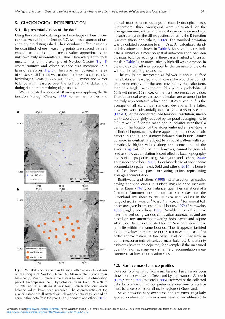
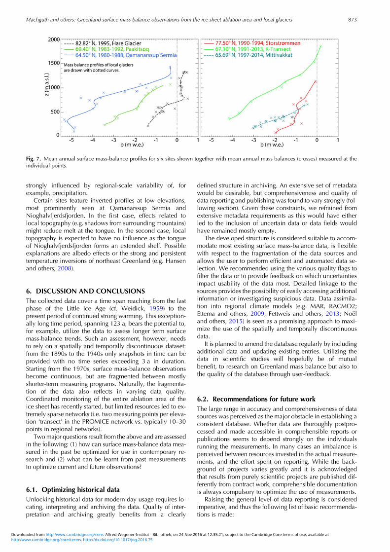