greene county infrastructure inventory & development
TRANSCRIPT

Final Report
0
Greene County Infrastructure Inventory and Development Project
Prepared for:
Greene County Economic Development and Tourism
411 Main Street Catskill, New York 12414
Prepared BY:
With:
Elan.3 Consulting
March 2017
Made possible through a grant from

Final Report
1
Table of Contents Introduction ........................................................................................................................................................ 3
Water and Wastewater Infrastructure ............................................................................................................... 4
1. Town of Ashland ......................................................................................................................................... 5
2. Town of Athens ........................................................................................................................................... 5
3. Village of Athens ......................................................................................................................................... 5
4. Town of Cairo .............................................................................................................................................. 5
5. Town of Catskill........................................................................................................................................... 6
6. Village of Catskill ......................................................................................................................................... 6
7. Town of Coxsackie ...................................................................................................................................... 6
8. Village of Coxsackie .................................................................................................................................... 6
9. Town of Durham ......................................................................................................................................... 6
10. Town of Greenville ................................................................................................................................... 6
11. Town of Halcott ........................................................................................................................................ 7
12. Town of Hunter ......................................................................................................................................... 7
13. Village of Hunter ....................................................................................................................................... 7
14. Village of Tannersville ............................................................................................................................... 7
15. Town of Jewett ......................................................................................................................................... 7
16. Town of Lexington .................................................................................................................................... 7
17. Town of New Baltimore ............................................................................................................................ 7
18. Town of Prattsville .................................................................................................................................... 7
19. Town of Windham .................................................................................................................................... 8
Water and Wastewater Infrastructure – Expansion, Extension, and Creation .................................................. 8
Land Use and Zoning: The State of Zoning in Greene County, New York .......................................................... 9
What does the IDA Look for in Developable Parcels? ...................................................................................... 12
Potential Economic Development Sites ........................................................................................................... 12
1. Existing Shovel-Ready Sites ...................................................................................................................... 13
2. MLS-Listed Properties ............................................................................................................................... 13
3. County-Owned Vacant Land ..................................................................................................................... 14
4. Privately-Owned Land .............................................................................................................................. 15
5. Business Corridors .................................................................................................................................... 15
6. Agricultural Lands ..................................................................................................................................... 16
7. Environmental Constraints and Recreational Opportunities ................................................................... 16
7.1 Funding for Recreational Opportunities ............................................................................................. 18

Final Report
2
Infrastructure Funding Opportunities .............................................................................................................. 19
Recommendations ............................................................................................................................................ 19
List of Attachments Attachment 1. Overview Map of Greene County Infrastructure Attachment 2. Greene County Water and Sewer Capacity Summary Table Attachment 3. Greene County Water and Sewer Infrastructure Maps Attachment 4. Zoning: Zoning Map and Zoning/Land Use Controls Table (ELAN) Attachment 5. MLS-Listed Properties Map Attachment 6. County-Owned Vacant Land Map Attachment 7. Privately-Owned Land Maps Attachment 8. List of Privately-Owned Lands Attachment 9. Business Corridors Maps and List of Corridor Parcels Attachment 10. Map of Agricultural Land and Agricultural District 124 Attachment 11. List of Agricultural Land Attachment 12. Environmental Constraints Map List of Figures Figure 1. Map of Greene County Figure 2. Greene County Agricultural Map Figure 3. Typical Development Considerations Figure 4. Greene County Business Corridors Figure 5. Catskill State Park Map Figure 6. NYS Watershed Map List of Tables Table 1. Greene County Water Systems and Capacities Table 2. Greene County Sewer Systems and Capacities Table 3. MLS-Listed Properties Table 4. County-Owned Land
Final Report
3
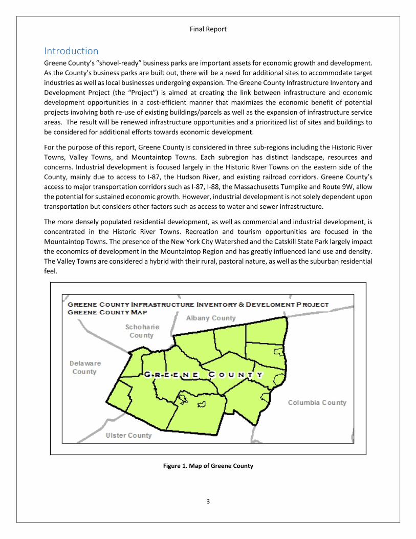
Introduction Greene County’s “shovel-ready” business parks are important assets for economic growth and development. As the County’s business parks are built out, there will be a need for additional sites to accommodate target industries as well as local businesses undergoing expansion. The Greene County Infrastructure Inventory and Development Project (the “Project”) is aimed at creating the link between infrastructure and economic development opportunities in a cost-efficient manner that maximizes the economic benefit of potential projects involving both re-use of existing buildings/parcels as well as the expansion of infrastructure service areas. The result will be renewed infrastructure opportunities and a prioritized list of sites and buildings to be considered for additional efforts towards economic development.
For the purpose of this report, Greene County is considered in three sub-regions including the Historic River Towns, Valley Towns, and Mountaintop Towns. Each subregion has distinct landscape, resources and concerns. Industrial development is focused largely in the Historic River Towns on the eastern side of the County, mainly due to access to I-87, the Hudson River, and existing railroad corridors. Greene County’s access to major transportation corridors such as I-87, I-88, the Massachusetts Turnpike and Route 9W, allow the potential for sustained economic growth. However, industrial development is not solely dependent upon transportation but considers other factors such as access to water and sewer infrastructure.
The more densely populated residential development, as well as commercial and industrial development, is concentrated in the Historic River Towns. Recreation and tourism opportunities are focused in the Mountaintop Towns. The presence of the New York City Watershed and the Catskill State Park largely impact the economics of development in the Mountaintop Region and has greatly influenced land use and density. The Valley Towns are considered a hybrid with their rural, pastoral nature, as well as the suburban residential feel.
Figure 1. Map of Greene County

Final Report
4
Greene County was number one in the state in percentage job growth in 2014 and has identified the need for additional potential commercial and industrial development sites as critical to maintaining and expanding job growth opportunities. While Greene County has continued to grow its population in recent years, many of the previously prepared sites for economic development have been utilized by companies such as Empire Merchants, National Bedding, Ducommun AeroStructures, and the Ferguson Waterworks warehouse/distribution center constructed in 2015.
This Project will allow Greene County and its communities to develop further strategies that maximize existing infrastructure and channel investment in infrastructure improvements to support environmental protection and economic development. All forms of economic development rely on the capacity, sustainability, viability, and cost of the underlying public infrastructure.
Water and Wastewater Infrastructure The provision of sufficient quantities of good quality drinking water is an important goal of every community in Greene County. Water and wastewater infrastructure, or lack thereof, can be a restriction to economic growth and employment, especially for impoverished individuals in distressed communities. The availability of water and wastewater capacity and the cost of services are vital to business retention, expansion, and attraction.
As part of the Project, existing water and sewer systems in the County were inventoried and identified including publicly-owned and significant privately-owned systems (Attachment 1, Overview Map of Greene County Infrastructure). A basic evaluation was completed for the permitted capacity and service areas for each system including quantitative data regarding existing demands for service (Attachment 2, Greene County Water and Sewer Capacity Summary Table). Descriptions and of municipalities’ existing infrastructure is provided below and throughout this text. Individual maps of each municipality showing infrastructure can be found in Attachment 3.
Table 1. Greene County Water System Capacities Table 2. Greene County Sewer System Capacities
Water System Rated
Capacity (MGD)
Current Avg
Demand (MGD)
Remaining Capacity
Sewer System
Rated Capacity (MGD)
Current Avg Flow
(MGD)
Remaining Capacity
% MGD % MGD Ashland 0.062 0.007 88.70% 0.055 Athens (V) 0.4 0.185 53.75% 0.215 Athens 0.500 0.226 54.80% 0.274 Athens (V) 0.017 0.013 23.53% 0.004 Cairo 0.216 0.146 32.41% 0.070 Cairo SD 0.089 0.051 42.70% 0.038
Catskill 2.000 0.847 57.65% 1.153 Catskill (T) 0.026 0.014 46.15% 0.012 Coxsackie 1.200 0.713 40.58% 0.487 Catskill (V) 1.55 0.868 44.00% 0.682 Greenville 0.079 0.071 10.35% 0.008 Coxsackie (V) 1.25 0.879 29.68% 0.371
Hensonville 0.240 0.039 83.75% 0.200 Hunter (V) 0.326 0.127 61.04% 0.199 Hunter 0.360 0.236 34.44% 0.124 New Baltimore (T) 0.06 0.015 75.00% 0.045
Prattsville 0.062 0.020 67.70% 0.042 Tannersville (V) 0.8 0.13 83.75% 0.67 Tannersville 0.622 0.409 34.25% 0.213 Windham (T) 0.445 0.1865 58.09% 0.2585
Windham 0.240 0.043 82.08% 0.197 Greenville (T) 0.058 0.021 63.79% 0.037
Sleepy Hollow 0.06 0.047 21.67% 0.013
Machne Tashbar 0.026 0.017 34.62% 0.009
Ashland 0.026 0.0095 63.46% 0.0165
Lexington 0.025 - - -
Prattsville 0.086 0.021 75.58% 0.065

Final Report
5
1. Town of Ashland The Town of Ashland, located in the northwestern portion of Greene County, along the Schoharie County border, has a public water distribution system as well as a community septic system that serve parcels located in the Hamlet of Ashland along Route 23 and the Batavia Kill.
The water system was completed in 2014 and includes water supply wells, pump station and housing for mechanical and disinfection equipment, water mains and associated equipment, and a water storage reservoir.
In Ashland, as in many cases, the NYC Watershed-funded community septic systems are not intended to provide additional capacity and are not structured for easy expansion. The current rated capacity of the septic system is 0.026 MGD. The Town is served by a small diameter gravity sewer collection system where septic tank effluent is conveyed to the WWTP that uses a UV disinfection system as a final treatment step.
2. Town of Athens The Town of Athens does not own or operate water or wastewater infrastructure; however, areas of the Town in proximity to the Village of Athens water and sewer systems are served by those systems. The Village of Athens source water, water treatment plant and water storage are located in the Town of Athens at Hollister Lake. Sleepy Hollow Lake WTP and WWTP, located within the Village, are owned and operated by the Sleepy Hollow Lake Association of Property Owners. These facilities serve properties in both the Town and Village of Athens located around Sleepy Hollow Lake.
3. Village of Athens The Village of Athens owns and operates a WWTP located within the down-town area of the Village. The sewer system serves the Village as well as limited areas in the Town of Athens. The Village also operates a small WWTP which serves the Brick Row community. The Village WWTP has recently been upgraded; the Brick Row WWTP is nearing the end of its useful life.
Sleepy Hollow Lake WTP and WWTP, located within the Village, are owned and operated by the Sleepy Hollow Lake Association of Property Owners (APO). These facilities serve properties in both the Town and Village of Athens located around Sleepy Hollow Lake. The APO water and sewer systems are both currently the focus of capital improvements to extend the useful life of the facilities and achieve sustainable regulatory compliance.
The Village owns and operates a WTP with a main source of water at Hollister Lake. The WTP is located in the Town of Athens on the Schoharie Turnpike. The WTP serves the Village as well as portions of the Town and was upgraded within the past ten years.
4. Town of Cairo The Town of Cairo owns and operates a WWTP and a water distribution system, which relies on wells for water supply. Water storage is provided by a 365,000 gallon tank. The WWTP was constructed in 2000 as an alternative design gray-water system, which utilizes on-site septic tanks, force mains, and relatively small diameter gravity sewer installed at a shallow depth. Both systems serve the central business area along Main Street, near the Route 145, 32, and 23 intersections. The Town water system is currently the subject of capital improvements.

Final Report
6
5. Town of Catskill The Town of Catskill, located on the Hudson River on the eastern side of Greene County, does not own or operate a WTP; however, the Village of Catskill water system has a transmission line which has been tapped to provide water service in the Town of Catskill in the hamlets of Leeds and Jefferson Heights. The Town recently formed a Water District to provide governance for the water service provided by the Village to properties located in the Town. The Town is currently installing a sewer system which serves the areas of Leeds and Jefferson Heights within the Town. Wastewater collected in this new system will be conveyed to the Village WWTP. In addition, a small Town-owned WWTP is located at the southern end of the Town which serves the Hamlet of Cementon.
6. Village of Catskill The Village of Catskill owns and operates a WWTP and a water treatment and distribution system. The Catskill water system’s water source is the Potic Reservoir located in the Town of Coxsackie on Schoharie Turnpike. The Village WWTP is located on Main Street near the confluence of the Catskill Creek and the Hudson River. The Village systems serve the Village as well as some properties in the Town of Catskill.
7. Town of Coxsackie The Town of Coxsackie does not own or operate a WTP or WWTP; however, the Town owns and contracts for operations with the Village of Coxsackie water and sewer lines. Portions of the Town are served by the Village-owned WTP and WWTP. The Town has several water and sewer districts.
8. Village of Coxsackie The Village of Coxsackie owns and operates a WTP and WWTP. The WTP is located in the Town of Coxsackie and serves the Village as well as portions of the towns of Coxsackie and New Baltimore. The WWTP is located in the heart of the Village on the Hudson River and also serves the Village as well as portions of the towns of Coxsackie and New Baltimore. Industrial sites, including the County IDA Industrial Parks and the Hudson Valley Business Park are provided with water and sewer service by the Village through infrastructure owned and operated by the towns of Coxsackie and New Baltimore.
The WTP was recently upgraded to achieve regulatory compliance and increase capacity. The Village WWTP is scheduled for major capital improvement prior to 2020 which will address regulatory compliance and extend the useful life of the facilities.
9. Town of Durham The Town of Durham, located in northern Greene County along the Albany County border, does not have public water or wastewater infrastructure.
10. Town of Greenville The Town of Greenville owns and operates a WTP and a WWTP that serve portions of the Town. Both systems have been updated recently.
The public water supply system was first installed around 1900. The Town of Greenville Water District #1 covers approximately 5% of the Town’s land area. The district boundaries intersect NYS Route 32 one mile north of, and 2,400 feet south of the Town’s center. Water is supplied from 3 bedrock wells.
The Town of Greenville Sewer District No. 1 was originally established as the Joint Effort Private Sewer Company (JEPSCO) which was formed as a Transportation Corporation in 1991. The Town took over the

Final Report
7
system in 2004. The system consists of gravity sewer main, manholes, a pump station and the WWTP itself. A sewer district extension is currently underway which will extend service along NYS Route 32 and Route 81.
11. Town of Halcott The Town of Halcott, located in western Greene County along the Ulster and Delaware County borders, does not have public water or wastewater infrastructure.
12. Town of Hunter The Town of Hunter, located in southern Greene County along the Ulster County border, does not own or operate public water or wastewater infrastructure. Portions of the Town are served by water and sewer infrastructure owned by the Villages of Hunter and Tannersville. Machne Tashbar, a large privately-owned WWTP, serves a seasonal camp located in the southeastern corner of the Town.
13. Village of Hunter The Village of Hunter owns and operates a WTP and a WWTP. These systems also serve portions of the Town of Hunter. The WWTP and collection system were funded by the City of New York New Sewage Treatment Infrastructure Program. The WWTP and collection system provide robust capacity to support economic development. The Village water system was created through the consolidation of the assets of a number of private water companies.
14. Village of Tannersville The Village of Tannersville owns and operates a WTP and is served by a WWTP owned and operated by the City of New York. These systems also serve portions of the Town of Hunter. The WTP is subject to a capital improvement project aimed at meeting regulatory requirements and extending the useful life of the facility.
15. Town of Jewett The Town of Jewett, located in southwestern Greene County, does not have public water or wastewater infrastructure.
16. Town of Lexington The Town is not served by public or private water treatment systems; however the Town is in the planning phase of developing a City of New York funded community septic system with a capacity of approximately 0.025 MGD which includes over 60 connections. Septic tank effluent will be conveyed to a treatment site that includes absorption beds.
17. Town of New Baltimore The Town of New Baltimore owns and operates a WWTP located in the northeastern area of the Town which serves the Hamlet of New Baltimore. The portion of the Kalkberg Commerce Park that is within New Baltimore is served by the Coxsackie WTP and WWTP. Properties in the northern portion of the Town are provided potable water through an intermunicipal agreement with the Village of Ravena in Albany County.
The Town WWTP is currently subject to an upgrade to extend the useful life of the facilities.
18. Town of Prattsville The Town of Prattsville, located at the northwestern corner of Greene County, along the Schoharie and Delaware County borders, has a public water distribution system and a community septic system that serve parcels located in along Route 23 and the Schoharie Creek. Construction of the community septic system was

Final Report
8
funded by the City of New York. In Prattsville, as in many cases, the community septic systems is not intended to provide excess capacity and it is not structured for expansion.
19. Town of Windham The WWTP was constructed by the Town with funding from the City of New York through the New Infrastructure Program. The Town of Windham WWTP became operational in 2005 and serves properties in the hamlets of Windham and Hensonville. The system is robust and has excess capacity to support economic development.
The Town of Windham owns and operates two separate water supply distribution systems, both located within Windham Water District No. 1. The systems serve the Hamlet areas of Windham and Hensonville and improvements to these systems are currently under construction. The Town is engaged in a project to extend service, improve water treatment and create a backup interconnection between the Town-owned water systems with the Ski Windham-owned water system, which serves the ski mountain as well as some nearby private residences. Eventually, the two Town water systems will be connected along South Street, creating a single system with much existing capacity for future connections.
Water and Wastewater Infrastructure – Expansion, Extension, and Creation Public infrastructure is an important factor for economic development, providing a community the capacity to provide for existing and future development. Improvements to existing infrastructure require substantial financial means. The addition of new or the expansion of existing infrastructure also requires significant public investment and can impact community character and safety. Such expansion requires careful thought with regard to growth inducing impacts. It is untenable to consider a built-it-and-they-will-come plan for infrastructure expansion, extension and creation as it burdens the users of today with costs for the benefit of future users who may or may not materialize to support the cost of debt and operations and maintenance. This section focuses on efforts that can be taken at little or no cost to provide enhanced infrastructure services and how to plan for the future so that the actions of the present do not foreclose but rather facilitate future economic development opportunities.
Water and wastewater resources, technical capacity and financial considerations affect every town and village in the County. Mechanisms such as shared services, expansions of service, and the formation of new districts and service areas offer communities additional resources and technical and financial capabilities relative to the provision of water and sewer. As a rule of thumb, every mile of water or sewer infrastructure constructed to serve future development costs $1 million if constructed by a municipality. Some savings are gained if the construction is not subject to public bidding, perhaps 10% and the construction of both water and sewer simultaneously can provide an economy of scale; however, such a reduction is perhaps another 10% cost savings only. The cost to expand water and sewer plants and related infrastructure will vary greatly depending on the nature of the systems to be expanded.
Fortunately for the communities within Greene County, the layout of villages and hamlets has allowed for at least initial stages of infrastructure and in many cases municipalities own and operate advanced water and sewer systems that are planned for future regulatory compliance and incorporate reasonable growth capacity. However, some communities are still lacking public sewer and water systems, leaving residents to rely on groundwater wells and on-site septic systems.

Final Report
9
As communities contemplate capital investments and planning for infrastructure, the following should be considered:
• Opportunities for shared services o Source water o Treatment facilities o Equipment used for operations and maintenance o Personnel
• Treatment Unit Process sizing o For wastewater systems, collection system pump stations and forcemains as well as the
preliminary treatment should be sized sufficiently to accommodate peak hydraulic flows as well as a growth projection
o Select technologies that are readily expandable o Consider construction of tankage that can accommodate additional equipment in the future
for expansion o Layout plant sites to ensure land base is available for future construction o Ensure that extensions of distribution and collection pipelines are sized to serve a future
area, not just a single project • Anticipate future regulatory matters and plan for flexibility to add equipment and processes as
needed without major reconstruction
Large segments of land in the Mountaintop area of the County are owned and/or managed by the NYCDEP to protect the drinking water of New York City. To further protect the tributaries and reservoirs that supply this drinking water, several municipalities are undergoing or have undergone either the upgrade of existing sewer facilities or the construction of entirely new wastewater systems. While the City of New York funds both the capital and operating costs of sewer infrastructure mandated by the Watershed MOA, the Watershed regulations create an increased burden on land owners and the cost of non-City funded infrastructure is high.
As communities in the Watershed review comprehensive plans and zoning (where applicable), consideration as to access to existing water and sewer infrastructure should be a guiding principle with respect to desired future land uses.
Land Use and Zoning: The State of Zoning in Greene County, New York New York is a ‘home rule’ state, meaning that the legislature has delegated considerable authority to individual municipalities to regulate land use within their borders. Greene County consists of 19 municipalities; 5 villages and 14 towns covering a land area of 658 square miles. Each municipality has developed its own set of land use and subdivision regulations, each with a varying degree of complexity.
According to the 2010 US Census, Greene County’s population was 49,221.Roughly 74.8 people per square mile. However, the population is not evenly distributed across the county. The majority of the population is located along the Hudson River, following historical settlement patterns, in Catskill, Athens, and Coxsackie. Accordingly, the land use controls in the more populated, eastern half of the county are more advanced.
Notably, 79,200 acres of the Catskill Forest Preserve are within Greene County. This is primarily in the south eastern area of the county. Jewett (T), Hunter (T), Tannersville (V), and Hunter (V) are completely within the Catskill State Park as is the majority of Lexington (T). Public lands within the Catskill State Park are subject to

Final Report
10
The Catskill State Park State Land Master Plan (CPSLMP). The privately owned land within the boundary of the Catskill Preserve is primarily agricultural and residential.
The Greene County Agricultural Development and Protection Plan, adopted in 2002, established numerous Agricultural Districts pursuant to Agriculture and Markets Law 25AA. The plan is intended to protect productive farmland from non-agricultural development. Land use decisions in and adjacent to designated agricultural districts are subject to review by the Greene County Agricultural and Farmland Protection Board. Greene County maintains maps of county agricultural districts on their website.
Figure 2. Greene County Agricultural Map
The following municipalities have very basic zoning:
Ashland (T): The Town of Ashland adopted an “Interim Zoning Ordinance” in 1975 which separates the town into two districts- Flood Zone (as determined by FEMA 100 year flood maps) and non-Flood Zone. There is no substantial regulation of land outside of the 100 year flood zone asides from a provision that a building permit must be obtained for new construction. For practical purposes the Town of Ashland does very little to regulate where structures outside of the 100 year flood zone are built.
Halcott (T): The Town of Halcott (pop 258) established zoning in 2009. The town (partially within the Catskill Forest Preserve) has just one district. The district is largely intended to preserve the rural residential and agricultural character of the town. The district allows most residential and agricultural development ‘by right’ but restricts almost all non-agricultural commercial and industrial development to special use permit. Wind energy conversion, mining and large commercial structures are subject to a higher level of scrutiny than residential development and have corresponding supplemental regulations.
The following municipalities have developed and maintain modern zoning codes.
Athens (T): The Town of Athens (pop 4,089) established zoning in 1986 and updated the ordinance in 2011. Commercial and industrial development is encouraged primarily in the light industrial districts (1 & 2) and the mixed-use commercial district. These districts are mainly along routes 28 and 9W.

Final Report
11
Athens (V): The Village of Athens (pop 1,668) adopted zoning in 1994 and has made updates to the ordinance in keeping with some recommendations from a 2007 joint Town and Village Comprehensive Plan. The most recent updates were adopted in 2015. Almost all commercial uses require a special use permit. Districts along the Hudson River (Commercial and Mixed-Use Districts) are the most favorable for larger scale commercial and industrial development.
Greenville (T): The Town of Greenville (pop 3,739) established zoning in 2001 and updated the ordinance in 2015. Commercial and industrial development is encouraged in the Highway Commercial and General Commercial Districts along Route 32 and 81.
Coxsackie (V): The Village of Coxsackie (pop 2,813) bordering the western shore of the Hudson River adopted zoning in 2008. The industrial districts are located along the Hudson River and on the western side of town along an existing rail corridor.
Coxsackie (T): The Town of Coxsackie (pop 8,918) encompasses the Village of Coxsackie. The town adopted zoning regulations in 2008. The town is primarily rural residential/agricultural. Industrial, Corridor Industrial and Commercial districts are concentrated in the norther portion of the town.
Cairo (T): The Town of Cairo (pop 6,670) located in the center of Greene County. The town is bisected by highways 32 and 23. The western side of town is mountainous and zoned as “Mountain District.” The eastern side of town is primarily rural residential. Commercial and industrial development is permitted mainly in the central portion of town.
Catskill (T): The Town of Catskill (pop 11,775) is on the western shore of the Hudson River adopted zoning ordinance in 1988 and revised them in 1995. A recent comprehensive plan update (2007) prompted some revisions. A large industrial zone in the southern portion of town along Route 9W is most supportive of large-scale commercial development.
Catskill (V): The Village of Catskill (pop 4,081) adopted zoning in 2008 and revisions in 2013. The Village is centered around Catskill Creek which feeds into the Hudson River. The Central Commercial District on the northern shore of Catskill Creek is most supportive of larger commercial development.
Jewett (T): The Town of Jewett (pop 953) is located in the central western portion of Greene County and is generally mountainous. The land is zoned primarily for conservation and rural residential. Some limited commercial development is allowed by special permit in two Hamlets at either end of the Town.
Lexington (T): The Town of Lexington (pop 805) located to the west and south of Jewett is similarly mountainous. The zoning regulations favor conservation and rural residential development. Steep slopes and Catskill Forest preserve lands are prohibitive.
New Baltimore (T): The Town of New Baltimore (pop 3,370) located on the far northeastern edge of Green County along the Hudson River adopted zoning in 1977 and updated the ordinance in 2009. The town is mostly zoned as Rural/ Residential. Areas zoned for commercial and industrial uses are concentrated around Interstate 87 and Route 9W.
Hunter (V): The Village of Hunter (pop 502) established zoning in 2013. Larger commercial uses are permitted by special permit in the Gateway Business Districts on either edge of the village. The zoning ordinance includes a floating “Planned Development District” (PDD) to allow for more flexible zoning.
See Attachment 4, Greene County Zoning Map and Zoning/Land Use Controls Table for further information on zoning regulations in Greene County.

Final Report
12
What does the IDA Look for in Developable Parcels? The Greene County IDA has demonstrated impressive success in the development of shovel ready business parks which have each begun with an anchor tenant and have resulted in the creation of substantial economic activity and employment in the County. However, the inventory of shovel ready or pre-planned sites is presently very low. With the history of the County, a need to create new ready to go sites for economic development has been identified.
The County is in competition with other areas in the Region and in particular those areas with excellent highway or multi-modal access. Greene County has leveraged highway access (the area around Exit 21B for warehousing and distribution as well as light manufacturing) and rail access (Schoharie Turnpike in Athens); however, existing land base that is accessible and shovel ready (e.g. infrastructure is permitted and in place) is very limited. The site selection industry is highly competitive, with locations selected based on reduced cost to develop a site (e.g. no added cost to extend infrastructure) and reduced time to construction (e.g. SEQR and all permits are in place). The following figure summarizes typical development considerations.
Typical Development Considerations
Regional and Local Factors Natural Features Design and
Aesthetics Circulation Miscellaneous
Relationship to Local Laws (i.e. Zoning, Comprehensive Plan)
Geology Site Usage Vehicular Construction Specifications
Compatibility with Surroundings Topography Structures
Accessibility Soil Characteristics -Relationship to
Site Plans Ingress and Egress
-Pedestrian Vegetation -Elevations -Road Layout Utilities
-Automobile Wildlife -Functional Adequacy -Parking Areas
Economic Impact Open Space Architectural Features -Loading
Areas
Fiscal Impact Surface Drainage Signs -Traffic
Control
Environmental Impact Erosion Maintenance
Facilities and Services Available Ground
Waters Landscaping Pedestrian
Visual Compatibility Wetlands -Walkways
Historic and Archaeologic Considerations Flood Hazard
Areas Recreation Areas -Safety Staging of Development
Adapted from: Site Plan Review: James A. Coon Local Government Technical Series 2012
Figure 3. Typical Development Considerations
Potential Economic Development Sites Over the past ten years, in interest of commercial and light industrial sites in Greene County has led to an aggressive program for the creation of shovel-ready sites. The majority of the industrial park development in the County has been located in the Historic River Towns due to the availability of flat vacant land, transportation infrastructure and access to water and wastewater infrastructure. Future development could

Final Report
13
be located in the Valley Towns, especially along the Route 23 and 145 corridors, but this subregion faces limitations with respect to water and wastewater infrastructure.
Key areas targeted for future commercial and industrial development in Greene County will have significant environmental, archeological and infrastructure limitations that must be addressed prior to large-scale development. Infrastructure, specifically water and sewer, presents significant limitations to support future growth and development. Infrastructure is not only available in limited geographic areas, but the existing infrastructure, while the focus of significant recent investment, requires continued financial support for operations and maintenance to provide reliable services.
Potential Economic development sites were identified throughout Greene County as part of the Project. These sites were chosen based on a specific set of established criteria that meets the needs of economic development within the County. Over 38,000 parcels were evaluated in the initial stages of the Project and a total of 185 were selected as potential development sites based on the specified criteria. They are described in detail below.
1. Existing Shovel-Ready Sites Several primary areas have been targeted for the development of industrial parks within the County. These areas include fully shovel-ready business parks and former industrial areas that require various levels of redevelopment to meet current standards, as well as open, vacant, underutilized or undeveloped spaces that may face challenges before they can be developed.
There are four County-IDA business parks: Kalkberg Commerce Park, Greene Business & Technology Park, Hudson Valley Business Park and Fountain Flats Park. Several of these parks have been approved by the State of New York as shovel-ready. The Hudson Valley Business Park, located in the Village of Coxsackie, has water infrastructure in place but is lacking stormwater infrastructure and has extensive environmental constraints. While Empire Zones are no longer supported by the State, it is informative to note that Greene County designated an area in the Town of Catskill, south and west of the Village of Catskill, as Greene County Empire Zone Area 4. Catskill is the most populous Town in the County and the site is in close proximity to US Route 9W as well as Exit 21 of the New York State Thruway. The CSX main freight line also runs within Empire Zone Area 4.
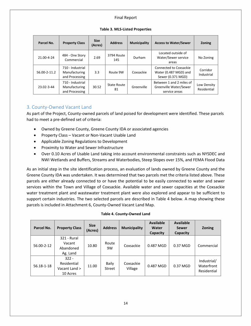
2. MLS-Listed Properties Three parcels were identified that could be used for future development. These parcels are listed on the Multiple Listing Service (MLS) for Real Estate Properties. These parcels have existing buildings located on-site. Only one parcel (56.00-2-11.2) is connected to water and sewer infrastructure in the Village of Coxsackie. One parcel (23.02-3-44) is located between 1 and 2 miles of infrastructure in the Town of Greenville, so connection is feasible, albeit expensive, between $1M and $2M. The third parcel (21.00-4-24) is located in the Town of Durham, which lacks public water and sewer infrastructure. These properties were selected based on anecdotal evidence of such available sites that are poised for development in Greene County. These parcels are depicted in Attachment 5, MLS-Listed Properties Map, and Table 3 below.
Final Report
14
Table 3. MLS-Listed Properties
Parcel No. Property Class Size (Acres) Address Municipality Access to Water/Sewer Zoning
21.00-4-24 484 - One Story Commercial 2.69 3794 Route
145 Durham Located outside of
Water/Sewer service areas
No Zoning
56.00-2-11.2 710 - Industrial Manufacturing and Processing
3.3 Route 9W Coxsackie Connected to Coxsackie Water (0.487 MGD) and
Sewer (0.371 MGD)
Corridor Industrial
23.02-3-44 710 - Industrial Manufacturing and Processing
30.52 State Route 81 Greenville
Between 1 and 2 miles of Greenville Water/Sewer
service areas
Low Density Residential
3. County-Owned Vacant Land As part of the Project, County-owned parcels of land poised for development were identified. These parcels had to meet a pre-defined set of criteria:
• Owned by Greene County, Greene County IDA or associated agencies • Property Class – Vacant or Non-Vacant Usable Land • Applicable Zoning Regulations to Development • Proximity to Water and Sewer Infrastructure • Over 0.10 Acres of Usable Land taking into account environmental constraints such as NYSDEC and
NWI Wetlands and Buffers, Streams and Waterbodies, Steep Slopes over 15%, and FEMA Flood Data
As an initial step in the site identification process, an evaluation of lands owned by Greene County and the Greene County IDA was undertaken. It was determined that two parcels met the criteria listed above. These parcels are either already connected to or have the potential to be easily connected to water and sewer services within the Town and Village of Coxsackie. Available water and sewer capacities at the Coxsackie water treatment plant and wastewater treatment plant were also explored and appear to be sufficient to support certain industries. The two selected parcels are described in Table 4 below. A map showing these parcels is included in Attachment 6, County-Owned Vacant Land Map.
Table 4. County-Owned Land
Parcel No. Property Class Size (Acres) Address Municipality
Available Water
Capacity
Available Sewer
Capacity Zoning
56.00-2-12
321 - Rural Vacant
Abandoned Ag. Land
10.80 Route 9W Coxsackie 0.487 MGD 0.37 MGD Commercial
56.18-1-18
322 - Residential
Vacant Land > 10 Acres
11.00 Baily Street
Coxsackie Village 0.487 MGD 0.37 MGD
Industrial/ Waterfront Residential

Final Report
15
4. Privately-Owned Land Privately owned land was identified within Greene County (Attachment 7 & 8) that could provide for potential development locations. From the over 38,000 parcels located within the County, 70 were identified that met the project criteria. The selection criteria were based on the following:
• Property class of Vacant or Non-Vacant Usable Land only (exclude RPS Class 900, 800, 700, 600, 500, 400, 200, and 310-315)
• Excluded properties owned by Greene County, NYCDEP, NYSDEC, Land Trusts, local schools, etc. • Over 15 acres of usable land taking into account environmental constraints such as NYSDEC and
NWI Wetlands and Buffers, Streams and Waterbodies, Steep Slopes over 15%, and FEMA Flood Data
• Zoning – Parcels within zoning districts that did not allow commercial or industrial development were eliminated (i.e. residential, conservation, etc.)
Parcels were also evaluated based on distance from water and sewer infrastructure. A 1 mile and 2 mile buffer range was put in place to help narrow down potential economic development sites. As discussed previously in this report, it will cost approximately $1M per mile of infrastructure needed in order for an industrial developer to connect. These parcels range from 15 acres to over 230 acres in size and are found throughout the County.
An additional 45 parcels were identified that met the above criteria, but were outside of the 2 mile infrastructure buffer. As a result, these will not be explored further unless warranted and are not included in the Privately-Owned Parcel list in Attachment 8.
5. Business Corridors Commercial and light industrial development in the Mountaintop region may have to be smaller scale with smaller footprints due to limitations on flatter, developable land and the surrounding mountainous terrain of the Catskills. The NYC Watershed regulations also limit the type of development to those that would not in any way be a threat to drinking water.
Figure 4. Greene County Business Corridors

Final Report
16
Two areas were identified as Business Corridors during the course of the Project. These areas are close in proximity to downtown areas and would be suitable for retail and commercial development as opposed to large industrial development. These areas were also screened for environmental constraints such as steep slopes and wetlands.
The first area in the Town of Hunter, between the Village of Hunter and the Village of Tannersville, is within close proximity to the Villages’ water and sewer systems. Although, due to NYCDEP constraints, new users are not allowed to hook-up into the systems. This business corridor may be poised for smaller commercial development that can be served by joint or separate on-site water and septic systems. Parcels within this area are located within the Catskill State Park and the NYC Watershed.
The second area in the Town of Windham, between the Hamlet of Windham and the Hamlet of Hensonville, is within close proximity of the Town’s water and sewer systems. As such, new development could utilize the existing infrastructure or, in some cases, choose to be served by joint or separate on-site water and septic systems. These Business Corridors are depicted in Attachment 9 and are expected to meet the following during and after development:
• Encourage and support the development and growth of small businesses including technology, Main Street commercial, and the arts sector;
• Encourage the development and environmentally appropriate expansion of ski facilities and communities as an economic driver; and,
• Support environmentally and visually sustainable development to enhance a unique and attractive industry.
6. Agricultural Lands Agricultural land is a valuable and declining resource in Greene County. From a historical perspective, Greene County’s agricultural industry has been in decline from the 1950s. However, the land in agriculture has increased by approximately 10,000 acres since 1990, the reverse of the general trend, demonstrating opportunities for continued development in areas such as equine, organic vegetables production, agroforestry and agri-tourism. Active farming of viable agricultural parcels should be considered a priority and prime agricultural lands should be conserved to the maximum extent practicable.
As part of this Project, a list of agricultural lands were compiled, which met the following selection criteria:
• Property class was Agricultural (RPS Class 100’s) • Excluded properties owned by Greene County, NYCDEP, NYSDEC, Land Trusts, etc. • Must have 10 acres of usable land taking into account environmental constraints such as
NYSDEC and NWI Wetlands and Buffers, Streams and Waterbodies, Steep Slopes over 15%, and FEMA Flood Data
• Zoning data is included but was not part of the selection criteria
These parcels are depicted in Attachment 10, Map of Agricultural Land and Agricultural District 124, and listed in Attachment 11.
7. Environmental Constraints and Recreational Opportunities While environmental factors can constrain site development, they can bolster other types of economic activity such as Tourism. Tourism is a significant contributor to the Greene County economy. Greene

Final Report
17
County has a rich tradition of family-owned and operated tourism businesses and numerous resorts and lodging facilities. The area boasts tremendous natural beauty, offers significant opportunities for outdoor recreation and is home to a variety of historic sites and cultural facilities that make Greene County unique.
Greene County possesses a number of significant tourist attractions, cultural and recreational amenities, and related support businesses. In combination, these assets provide a solid foundation. The natural beauty of Greene County has always been a strong lure for visitors to the region. Greene County attracts hikers, hunters, campers, and many other outdoor recreation enthusiasts. Approximately 79,000 acres in Greene County are in the Catskill Forest Preserve, an area that covers more than 290,000 acres of State-owned land.
Figure 5. Catskill State Park Map
The Mountaintop municipalities of Prattsville, Ashland, Windham, Jewett, Hunter, Tannersville, Lexington, and Halcott are challenged from a site development perspective by steep slopes, such as soil erosion and flooding, and water quality before development can occur.
Valley Towns such as Durham, Greenville, and Cairo developed at a slower pace and were historically dependent upon farming. Today, a separate agenda of environmental concerns including protection of open space, farmland protection, and potential flooding problems exists for these municipalities.
Additionally, at all currently identified potential economic development sites, environmental constraints are likely to be a substantial limiting factor to development. In addition to the limitations resulting from the cost of site assessment and permitting, environmental mitigation is also very expensive.
This Project evaluated land development opportunities with respect to the current environmental constraints including steep slopes, wetlands, flood prone areas, streams and waterbodies, the Catskill State Park, and NYC Watershed. See Attachment 12 for a map of environmental constraints within Greene County.

Final Report
18
The NYCDEP enforces Watershed Rules and Regulations which impose limits on development in the area and include added environmental restrictions that are intended to protect the New York City drinking water supply. The presence of the Catskill State Park and the NYC Watershed largely impact the type of development that is supported on the Mountaintop Region and have greatly influenced the current land use and density of development there.
Figure 6. NYC Watershed Map
7.1 Funding for Recreational Opportunities While the Historic River Towns have a stronger commercial, industrial and residential presence, the Mountaintop communities of Hunter, Tannersville, and Windham possess a strong recreational and tourism focus. For areas where there are extensive environmental constraints, there are also many chances to expand on recreational tourism and bring economic prosperity through outdoor prospects. Funding opportunities for such prospects are listed below:
• The Office of Parks, Recreation and Historic Preservation, through the Environmental Protection Fund, offers a grant program for Parks, Preservation and Heritage. This program helps municipalities fund projects such as acquisition, planning and development, rehabilitation, or conservation for parks, heritage areas ad historic sites.
• The Department of State’s Local Waterfront Revitalization Program offers funding to municipalities located along New York’s coasts and designated inland waterways to revitalize communities and waterfronts through planning, design, and construction.
• The NYSDEC offers funding through the Catskill State Park Smart Growth Program which helps municipalities implement capital projects that apply smart growth principals. Projects include those such as updating a comprehensive plan, master plan, or outdoor recreational plan, and also implement improvements to downtown areas and parks.

Final Report
19
• DOS Water Quality Planning and Implementation Grants assist NYC Watershed communities in preparing and updating comprehensive plans, community development tools, and local laws.
Infrastructure Funding Opportunities For municipalities that wish to implement or expand on existing infrastructure there are many opportunities for funding. Costs will vary greatly for the design and construction of infrastructure depending on the geographic location, size of system, environmental constraints, etc. Funding opportunities are listed below:
• NYSEFC – State Revolving Fund, Water Infrastructure Grants, • NYSDEC – Water Quality Improvement Program, Engineering Planning Grants • NYSDOH – State Revolving Fund • CFA – Consolidated Funding Applications – numerous agencies • NYCDEP – Regulatory Upgrade and New Infrastructure Program • Empire State Development – Planning and Infrastructure programs • CWC – Septic and Stormwater Programs
Recommendations The Greene County Infrastructure Inventory and Development Project is intended to aid the County and municipalities in the consideration of infrastructure investments that maximize existing infrastructure and target improvements that foster economic development and environmental sustainability. Water and sewer infrastructure is the key to supporting existing residents and businesses, and to enhancing economic opportunities for the County, its municipalities and residents. Mechanisms such as shared services, planning for the future, expansion of services, as well as the formation of new special districts and service areas can offer communities additional resources and technical and/or financial capabilities relative to the provisions of water and sewer.
Based on results from the analysis portion of the Project, recommendations regarding infrastructure management and provisions were developed with an aim of maximizing the economic development potential of the identified sites:
1. As stated previously, extension of a water or sewer line conducted with public bidding is likely to cost $1 million a mile. The cost to expand source water and/or treatment capacity will vary widely depending on the system and technology. While extending infrastructure, increasing capacity, and/or sharing services can help to bring in more businesses and jobs with the prospects of available infrastructure, the build-it-and-they-will-come strategy is not recommended as it burdens the property owners of today with costs that may never be recovered if future users do not materials. Rather, the recommendation of this report is to plan public infrastructure in ways that does not foreclose any future opportunities for infrastructure expansions. This is done through technology selection, sizing of equipment and facilities, and space planning for future growth.
2. Each community that owns and operates water and sewer infrastructure should develop asset management plans that incorporate reasonable budgets for infrastructure maintenance (e.g. water line replacement and sewer lining projects). This type of investment is critical to supporting expansions in the future.

Final Report
20
3. Zoning and Land Use law changes can be made to direct and encourage commercial and industrial development in areas of each municipality within the County as appropriate to support the community and the region.
4. The IDA is currently evaluating a large site in the vicinity of Exit 21 in the Town of Catskill for potential development of a shovel ready site. While this is the focus of the current efforts of the IDA, initial consideration for additional sites is on-going. Given that potential development sites were identified in a number of different communities, it is recommended that the municipalities in which those sites were identified initiate the process of reviewing land use codes, environmental factors, and the status of infrastructure as a next step towards identifying likely sites for future economic development. The key is to look for substantial impediments to development that would discourage future investment. If none exist, the site or sites should be further considered for steps such as coordination with the land owner, land use code updates, and due diligence activities. In this way, new sites for potential economic opportunities may be advanced towards fruition.