green infrastructure program dwsd_green... · 2019-11-25 · greening of detroit green...
TRANSCRIPT

GREEN INFRASTRUCTURE PROGRAM
PROGRESS REPORT
August 1, 2013 (Fiscal Year July 1, 2012 – June 30, 2013)
DETROIT WATER AND SEWERAGE DEPARTMENT
PURSUANT TO REQUIREMENTS UNDER
NPDES PERMIT NO.
MI0022802 Prepared for: Michigan Department of Environmental Quality Prepared by: Southeast Michigan Council of Governments (SEMCOG) 535 Griswold, Suite 300 Detroit, MI 48226 313-961-4266

i
Table of Contents ........................................................................ 1
............................................................... 1
SEMCOG Green Infrastructure Coordination ......................................................................................... 1
Greening of Detroit Green Infrastructure Contract ................................................................................. 2
Green Task Force: Water Subcommittee .................................................................................................. 2
Detroit Strategic Framework .................................................................................................................... 3
Regional Green Infrastructure Vision Task Force.................................................................................... 3
Alliance of Rouge Communities (ARC) ..................................................................................................... 3
Southeast Michigan Green Infrastructure Team (SEM GI Team) ............................................................ 3
Alternative Financing Mechanisms .......................................................................................................... 3
Regional and National Conferences; Publications & Regulatory Agency Involvement ........................... 3
................... 4
Tree Planting ............................................................................................................................................ 6
Demolition and Greening Vacant Properties. .......................................................................................... 6
Downspout Disconnection ........................................................................................................................ 7
Roadways and Parking Lots ..................................................................................................................... 8
Municipal Properties ................................................................................................................................ 8
............................................................................... 8
Administration........................................................................................................................................... 9
Technical Issues ........................................................................................................................................ 9
Execution of Specific GI Projects ............................................................................................................. 9
............................................ 10

GREEN INFRASTRUCTURE PROGRAM - PROGRESS REPORT
August 1, 2013
Page 1
DWSD’s Alternative Rouge River CSO Control Program is designed to restore water quality and
protect public health while staying within its financial means by controlling rate increases that will be
needed to pay for new projects. The program encompasses a 25-year phased plan that focuses on Green
Infrastructure solutions along with “right-sized” conventional CSO control facilities. The purpose of this
report is to outline progress achieved on the Green Infrastructure Program during Fiscal Year 2012 -
2013. SEMCOG’s 205j grant funding from the MDEQ continued to support efforts to facilitate progress
on the development of DWSD’s Green Infrastructure Program for part of this fiscal year. Ongoing
activities have focused on continued discussions with City Departments and other agencies and
jurisdictions. Concurrent with these activities, the city-wide 2012 Detroit Strategic Framework Plan has
been completed. Initial planning for DWSD’s green infrastructure is consistent with this frame work.
This Annual Report is structured in the following manner:
Green Infrastructure Program Collaboration that outlines overall partnerships and activities
that support DWSD’s program;
Green Infrastructure Implementation in Fiscal Year 2012 – 2013 summarizes implementation
activities; and
Work Plan for Fiscal Year 2013 – 2014.
This section highlights general activities that have taken place in Fiscal Year 2012 – 2013 that
directly affect the ongoing development of DWSD’s Green Infrastructure Program.
SEMCOG Green Infrastructure Coordination
DWSD has contracted with SEMCOG to help facilitate various activities associated with the Green
Infrastructure Program. This includes coordinating activities and various communications between
departments, other jurisdictions and outside stakeholders. SEMCOG’s ongoing coordination supporting
the direction of DWSD’s Green Infrastructure Program are listed as follows:
Alliance of Rouge Communities to ensure integration of green infrastructure elements with the
319 Rouge River Watershed Management Plan;
Detroit Economic Growth Corporation to understand process of land assembly and vacant
properties;

GREEN INFRASTRUCTURE PROGRAM - PROGRESS REPORT
August 1, 2013
Page 2
Environmental Protection Agency and Wayne State University to assist in site selection for their
vacant property soil sampling research project;
Southeast Michigan Green Infrastructure Team and overall implementation in the region;
ERB Foundation and Detroit Works to coordinate overall green infrastructure activities in
Detroit;
Michigan Land Bank and Greening of Detroit to coordinate Vacant Lot Treatment Program,
including issues related to property ownership;
Lower Eastside Action Plan (LEAP) and Groundworks USA to collaborate on the green
infrastructure program and transferability;
Detroit Economic Growth Corporation and the Public Land Working Group to discuss the
process for and prioritization of vacant land parcels for future assembly towards large scale
greening efforts;
Wayne County regarding Joy Road infrastructure collaboration.; and
Grandmont Rosedale Development Corporation, Wayne County and the Rosedale-Grandomt
Little League regarding Stoepel Park green infrastructure collaboration.
Additionally, SEMCOG drafted DWSD’s Green Infrastructure Plan and coordinated a recent media
event about the greening of the ten (10) vacant lots in the Rouge Cody area. Appendix A contains the
media briefing, news release and a summary of the media coverage for the June 6th media event.
Greening of Detroit Green Infrastructure Contract
Performing services to DWSD under Contract CS-1546, Greening of Detroit has been a partner in the
Green Infrastructure program since its inception. During this fiscal year, the organization was
instrumental in installing trees, coordinating all downspout disconnection workshops, facilitating
community engagement for the Vacant Lot Treatment Program and implementing greening treatments on
vacant lots. These activities are discussed in more detail in this report.
Green Task Force: Water Subcommittee
City of Detroit Councilman Cockerel formed the Green Task Force that has a Water Subcommittee.
DWSD and SEMCOG continue to attend these meetings throughout the year. Additionally, SEMCOG
will be participating on the policy subcommittee. Earlier this year, the subcommittee established three
working groups to promote policy, education and technology initiatives aligned with the Detroit Water
Agenda, which are largely complimentary with DWSD initiatives in the Upper Rouge Tributary area.

GREEN INFRASTRUCTURE PROGRAM - PROGRESS REPORT
August 1, 2013
Page 3
Detroit Strategic Framework
The 2012 Detroit Strategic Framework completed its final recommendations and report this fiscal
year. SEMCOG has routinely coordinated efforts with this process to ensure consistency between city-
wide long-range decision making and DWSD’s green infrastructure program.
Regional Green Infrastructure Vision Task Force
DWSD is an active participant in SEMCOG’s Green Infrastructure Vision Task Force. This Vision is
designed to set long-term goals and recommendations for green infrastructure implementation across the
region. Detroit’s participation helps to establish priorities and ensure consistency between regional and
DWSD green infrastructure goals.
Alliance of Rouge Communities (ARC)
DWSD approved membership to the Alliance of Rouge Communities to further facilitate
collaboration with neighboring jurisdictions and watershed partners.
Southeast Michigan Green Infrastructure Team (SEM GI Team)
The MDEQ initiated a group of stakeholders that meet on a regular basis to work collaboratively on
moving green infrastructure forward within the Southeast Michigan region. Stakeholders include MDEQ,
MDNR, MDOT, SEMCOG, DWSD & MEDC.
Alternative Financing Mechanisms
DWSD is in the process of assessing impervious areas for parcels in the city for purposes of assessing
accurate stormwater fees. Billing for stormwater-only customers is expected in 2014. DWSD is
considering green credit options to provide incentives for customers to invest in Green Infrastructure and
reduce future runoff and stormwater charges. Several large customers have applied to the DWSD with
proposals to reduce stormwater runoff into the combined sewer system in order to reduce their respective
fees to DWSD. These proposals are being evaluated on a case-by-case basis.
Regional and National Conferences; Publications & Regulatory Agency Involvement
DWSD and SEMCOG have successfully partnered to submit abstracts to present papers at regional
and national conferences regarding DWSD’s Green Infrastructure Program. During Fiscal Year 2012 –
2013, DWSD presented at the following conferences:
USGBC Greenbuild Conference November 2012 and
2013 MWEA Annual Conference June 2013.
Additionally, DWSD’s Green Infrastructure Program was also discussed at local meeting groups as
part of overall regional green infrastructure activities. These included:

GREEN INFRASTRUCTURE PROGRAM - PROGRESS REPORT
August 1, 2013
Page 4
Regional GIS User’s Group Meeting;
Michigan Environmental Council Annual Southeast Michigan Meeting and
2013 Michigan Community Tree Seminar.
On the behalf of DWSD, SEMCOG also participated on a panel of experts as part of the Model D and
MetroMode Speaker Series: Backyard to Big Picture in May 2013 that provided opportunity to highlight
DWSD’s green infrastructure efforts. This event took place at Lawrence Technological University and
focused on various ways that green infrastructure is transforming the region.
Finally, SEMCOG partnered with Sanborn to publish a paper titled, “Creating a Healthier Planet:
From Smart Data Collection Planning to Effective Analysis and Implementation, regional planners in
Southeast Michigan are enabling urban sustainability and green infrastructure” in the Earth Imaging
Journal. The focus of this paper was on SEMCOG’s land cover analysis and processing, but also
included a component about the use of the data in relation to DWSD’s Green Infrastructure Program. See
also Appendix B.
This section summarizes this fiscal year’s ongoing implementation efforts and provides an estimate of
the runoff reduction benefits from these efforts. Implementation activities, including tree planting,
demolitions and vacant lot greening are shown in Figure 1, below. Consistent with previous years,
implementation primarily took place in the Rouge/Cody, Grandmont Rosedale and Brightmoor
neighborhoods.

GREEN INFRASTRUCTURE PROGRAM - PROGRESS REPORT
August 1, 2013
Page 5
Figure 1. Green Infrastructure Implementation Locations
GREEN INFRASTRUCTURE PROGRAM - PROGRESS REPORT
August 1, 2013
Page 6
The neighborhood groups have been very active in providing assistance in identifying priority
demolitions, participating in downspout disconnection workshops and public awareness and identifying
tree planting locations. Obtaining buy-in from the local residents and neighborhood groups is a crucial
component of the green infrastructure program and while this takes time and significant effort, increased
success will be realized in the future.
Tree Planting
Coordination with tree planting efforts across the CSO area includes the City of Detroit General
Services Department and Greening of Detroit (GOD). Street tree planting is implemented within the road
right-of-way between the sidewalk and curb along city and county roads and only in front of occupied
homes. Trees are also planted in City parks. Greening of Detroit also provides one-year of after-planting
care. The following list identifies the types of trees that were planted within the Upper Rouge Tributary
area:
Red Maple;
Swamp White Oak;
London Planetree;
American Elm;
Hackberry;
Red Oak;
River Birch;
Serviceberry;
Sweet Gum;
Kentucky Coffee Tree; and
Winter King Hawthorn.
Approximately 1,463 street trees were planted in the Fall 2012 and Spring 2013 within the Upper
Rouge tributary area. Trees were selected based on species biodiversity, appropriateness for Southeast
Michigan urban areas and interception/infiltration/evapotranspiration potential. As the tree canopy
coverage increases, the rainfall interception rates will increase with a decrease in stormwater runoff
entering the system.
Demolition and Greening Vacant Properties.
DWSD has been working with the Detroit’s Buildings, Safety Engineering and Environmental
Department (BSEED), to ensure appropriate follow-through and completion of the 140 demolitions
identified in the June 2012 Green Infrastructure Annual Report. To date, BSEED has not completed these

GREEN INFRASTRUCTURE PROGRAM - PROGRESS REPORT
August 1, 2013
Page 7
demolitions; thus DWSD is actively pursuing completion by BSEED and alternative approaches to get
this work accomplished in a timely manner
During FY 2012-2013, DWSD contracted with Michigan Land Bank (MLB) to complete twenty-
five (25) demolitions on properties under MLB ownership. MLB is on schedule to have this work
completed during the current summer season.
During Fiscal Year 2012 – 2013 DWSD also contracted with Greening of Detroit to restore ten (10)
MLB vacant lots in the area of Cody Rouge. This Vacant Lot Treatment Program consisted of a
community engagement process at the Cody Rouge Community Action Alliance Meeting. At this
meeting, both site prioritization and selection of the “greening” alternatives for each of the vacant lots
was determined. Appendix C includes a complete summary of the community engagement process.
Additionally, the following elements are components of the draft agreement with MLB:
DWSD will provide funds to MLB to implement the maintenance plan, potentially through a
workforce development program;
The agreement stays with the property even if property transfer takes place to ensure long-
term sustainability;
If the property is developed, the runoff reduction benefit shall be maintained; and
The public may access the property and the property may be utilized for public education
opportunities.
Downspout Disconnection
The program is currently being implemented with DWSD, Detroit Law Department, and BSEED.
One step is ensuring the regulatory mechanisms align restricting downspouts to be connected (Currently,
the antiquated City Code requires connection). While the City Law Department advised that a change of
ordinance was not required, DWSD believes the change of ordinance is a necessary part of the program.
First, it will align City regulations with state law thereby reducing confusion by City staff and the public.
Second, it will more easily allow for enforcement through code enforcement unit.
While this change to the code is in process, DWSD has actively initiated a residential education and
voucher program through the contract with Greening of Detroit in both the Rouge/Cody and Grandmont
Rosedale neighborhood areas. DWSD via Greening of Detroit has hosted 44 workshops (between
November 2012 and June 2013) on “how to” disconnect representing 211 households. Residents who
attend the workshops are provided a voucher to pick up the materials at Greening of Detroit offices. One
hundred sixty-five (165) vouchers for free materials (e.g., downspout elbow, extender, and plug) have

GREEN INFRASTRUCTURE PROGRAM - PROGRESS REPORT
August 1, 2013
Page 8
been redeemed by residents who have attended a workshop. A total of 642 residents have attended the 29
city-wide downspout disconnection educational sessions and 15 residents attended a workshop discussing
installation of rain barrels as part of the downspout disconnect program. Runoff reduction estimates are
provided in this report as an initial basis; however, inspections have not yet been completed to verify
proper disconnection. See Table 1, Green Infrastructure Program Financial and Runoff Reduction
Summary, on Page 10.
Roadways and Parking Lots
Meetings between SEMCOG, Wayne County, MDOT, DWSD and City of Detroit have been ongoing
to discuss incorporating green infrastructure designs into future roadway projects and to identify short-
term opportunities for green infrastructure implementation. While Joy Road was identified as an initial
priority, the timing for other infrastructure projects along roads being rehabilitated is still being
evaluated. SEMCOG completed traffic counts, has convened two meetings with Wayne County and
achieved a general agreement that working collaboratively on the Joy Road infrastructure project could
result in cost savings to both agencies. While achieving this general agreement is a large milestone, the
timing between the federal funding for the road project and DWSD projects may not align. The technical
and timing issues on this project will be resolved by DWSD’s green infrastructure engineering consultant
contract which has not yet been finalized.
Municipal Properties
Municipal properties include DWSD-owned properties, fire stations, police stations and DPW
facilities. Stoepel Park #1 initially became a primary focus for evaluating municipal property green
infrastructure opportunities. Many partners are involved with upgrading this park to serve as a focal point
for neighborhood activities. Partners included not only departments within the City, such as the
Recreation Department, but also included a commitment by Wayne County to construct a non-motorized
path as well as private donations from local vendors. DWSD’s interim green infrastructure consultant
created a conceptual plan to evaluate runoff reduction opportunities. To date, this plan is still under
review and will be further evaluated once contracting is complete with the new green infrastructure
engineering consultant. The plan depicts opportunities for underground storage and infiltration with an
annual runoff reduction of approximately 5.4 million gallons at an estimated cost of $2.7 million.
Our work efforts for FY 2013 -2014 will be focused in 3 major areas. These 3 areas will be:
1) Finalize contract with GI consulting engineer and establish administration
2) Technical Issues
3) Execution of specific GI projects

GREEN INFRASTRUCTURE PROGRAM - PROGRESS REPORT
August 1, 2013
Page 9
Administration
DWSD is very close to selecting the consulting engineer. This has been a large effort for DWSD
and extreme caution is being taken to ensure the best team for this effort is selected. After the contract is
awarded, a framework of the project for the next 5 years and a detailed work plan will be developed.
Some of the administrative issues that need to be resolved include the following:
Establish a tracking system for GI installations and runoff reduction;
finalize agreement with the MDEQ on calculation methodologies;
complete maintenance and deed restrictions for the greened vacant properties with Michigan
Land Bank;
establish policy and procedures for use by DWSD for green infrastructure installed in lieu of
stormwater fees;
determine how to incentivize and develop policies for loans or grants; and
define the outreach program.
Technical Issues
The technical issues that need to addressed are types of GI for property types, how to measure the
performance of installed GI, determine level of assistance for businesses and citizens, if any, develop the
menu of GI installations for each specific application, and optimization of the implementation of
downspout disconnection effort.
Execution of Specific GI Projects
Several efforts from previous years need to be completed and DWSD will target more tree
planting and demolitions at a minimum for this FY. The following tasks will be undertaken this year:
1. Tree planting will take place in the Fall 2013 and Spring 2014. Locations and quantities will be
determined at the coordination meetings.
2. Complete the 140 demolitions Commitment made in FY 2011-2012 report.
3. Complete the 25 MLB demolitions.
4. Continued implementation of the vacant lot greening program.
5. Make a final determination on the Joy Road reconstruction project and incorporating green
infrastructure; a substitute or supplemental project may be conceived in FY-13-14 to augment
similar green road and pedestrian friendly streets.
6. Pilot improved methods of deploying downspout disconnection.

GREEN INFRASTRUCTURE PROGRAM - PROGRESS REPORT
August 1, 2013
Page 10
These planned activities represent the current discussions taking place for the next fiscal year. It is
not intended to represent the only activities planned, but represents the overall direction for the next fiscal
year.
A consistent message regarding green infrastructure is the fact that it is typically designed to manage
smaller rain events up to the 2-year; 24-hour event. Using the same Curve Number Method methodology
since the inception of this program, an approximation of the runoff benefits for the tree planting, twenty-
five (25) demolitions, ten (10) vacant property treatments and one hundred sixty-five (165) residential lot
downspout disconnections is 78,600 gallons. The cumulative runoff reduction estimate for the green
infrastructure program to-date is 454,400 gallons.
Additionally, Table 1. Green Infrastructure Program Financial and Runoff Reduction Summary,
below, describes the budgeted or expended dollars for the activities described in this report and funded
through DWSD. Program funding expended during Fiscal Year 2012-2013 was $808,536. Based on
the previous two annual reports, the cumulative expenditures for green infrastructure implementation are
approximately $2,518,325. These costs are based only on the costs expended each fiscal year and do not
include life cycle costs which will be determined as the GI program matures.
Table 1. Green Infrastructure Program Financial and Runoff Reduction Summary
Green Infrastructure
Implementation
Activity
FY
2010-11
FY
2011-12
FY
2012-13
Cumulative
Expenditures
Cumulative
Estimated
Runoff
Reduction
(gallons)3
Cost/
Gallon
Demolition N/A $ 1,200,000 $ 250,000 $ 1,450,000 406,300 $4
Tree Planting1 172,000 $172,000 $172,000 $516,000 9,000 $57
Downspout
Disconnection2
N/A N/A $221,640 $221,640 28,400 $8
Vacant Lot Greening N/A N/A $25,000 $25,000 10,700 $2
Planning (SEMCOG,
Stoepel Park Concept) N/A $40,789 $64,896 $105,685 N/A N/A
Staff $50,000 $75,000 $75,000 $200,000 N/A N/A
Totals $222,000 $1,487,789 $808,536 $2,518,325 454,400 $6
N/A = not applicable
1Tree planting estimates converted from annual reduction to that based on 2-year; 24-hour event. This is based on
initial tree canopy area which increases annually. The annual increase is not included as part of this estimate. 2Downspout disconnection based on 165 vouchers redeemed. Inspections have not yet been

GREEN INFRASTRUCTURE PROGRAM - PROGRESS REPORT
August 1, 2013
Page 11
completed to verify disconnection.
3 Estimated runoff reduction based on TR-55 methodology.
4The final $6/gallon represents an overall cost given all planning and implementation costs and techniques
implemented.

APPENDIX A
MEDIA SUMMARY ON VACANT LAND TREATMENT
PROGRAM: BRIEFING; NEWS RELEASE & SUMMARY OF
COVERAGE
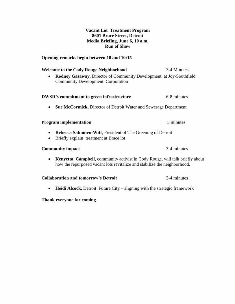
Vacant Lot Treatment Program
8601 Brace Street, Detroit
Media Briefing, June 6, 10 a.m.
Run of Show
Opening remarks begin between 10 and 10:15
Welcome to the Cody Rouge Neighborhood 3-4 Minutes
Rodney Gasaway, Director of Community Development at Joy-Southfield
Community Development Corporation
DWSD’s commitment to green infrastructure 6-8 minutes
Sue McCormick, Director of Detroit Water and Sewerage Department
Program implementation 5 minutes
Rebecca Salminen-Witt, President of The Greening of Detroit
Briefly explain treatment at Brace lot
Community impact 3-4 minutes
Kenyetta Campbell, community activist in Cody Rouge, will talk briefly about
how the repurposed vacant lots revitalize and stabilize the neighborhood.
Collaboration and tomorrow’s Detroit 3-4 minutes
Heidi Alcock, Detroit Future City – aligning with the strategic framework
Thank everyone for coming

Contact: Mary P. Alfonso, DWSD Contact: Trish Hubbell
Phone: (313) 964-9477 The Greening of Detroit
Mobile: (313) 999-2753 Phone: (313)285-2255
[email protected] Mobile: (313) 729-6109
The Greening of Detroit installs green infrastructure land treatments on 10 vacant lots
Detroit Water and Sewerage Department kicks off vacant lot greening program
Detroit, June 6: The last of 10 blighted, vacant lots owned by the Michigan Land Bank was treated with
green infrastructure today. The Detroit Water and Sewerage Department (DWSD), The Greening of
Detroit, and the Southeast Michigan Council of Governments (SEMCOG) are partnering on a pilot project
to transform 10 vacant residential property lots in the city’s Cody-Rouge neighborhood into greener,
healthier public spaces. The primary goal of the green infrastructure initiative is to reduce the amount
of storm water entering the sewer system, but the additional benefits of neighborhood stabilization,
improved property values, better air quality, and beautification are significant.
“We at DWSD believe in increasing green infrastructure in the city,” said DWSD Director Sue F.
McCormick. “Green projects help divert runoff from going into the combined sewer system, and that
could reduce costs that are passed on to our customers. The project in the Cody Rouge neighborhood is
one of the first steps in a multi-year greening program at DWSD. We’re excited about its potential.”
The Greening of Detroit is collaborating with Cody-Rouge neighborhood residents and community
groups to transform vacant residential lots into natural, low-maintenance spaces that will become
neighborhood assets.
Community residents were engaged in the process of selecting one of four low-maintenance treatment
plans for each location: a low-grow prairie grass; a perennial wildflower mix; a rye grass and wildflower
combination; and tree planting. The community voted on plans for each of the 10 properties.

-more-
-2-
“This pilot project will demonstrate how the use of natural seed mixes can help absorb more rain water,
stabilize property values, and decrease maintenance costs associated with vacant land across the city of
Detroit,” said Dean Hay, director of Green Infrastructure at The Greening of Detroit.
Repurposing vacant land in ways that add economic, environmental, and social benefits to Detroiters is
part of the vision laid out in the Detroit Future City strategic framework introduced in January. The
Greening’s Vacant Lot Treatment Program is an example of community engagement and successful
collaboration among multiple community, nonprofit, and municipal partners.
“Partnerships are essential for making green infrastructure work in our region and the City of Detroit.
Including the neighborhood in determining the types of green infrastructure, along with support from
the state, nonprofits, and the city is a winning combination for long-term success of this program.” said
Amy Mangus, Manager of Environmental Programs at SEMCOG.
“The type of partnership developed between public agencies and a local non-profit to execute this
important project is indicative of the formula needed to successfully implement the recommendations
within the strategic framework,” said Dan Kinkead, the Director of Detroit Future City. “Together they
used the framework to guide their approach to effect change in the Cody-Rouge neighborhood; each
using their particular strength to achieve the larger goal of improving the quality of life in Detroit and
creating a more environmentally and fiscally sustainable city.”
Treatment plans provide beautiful flowers, reduced maintenance, and natural habitats for birds. Trees cleanse the air by intercepting airborne particles, reducing heat, and absorbing pollutants such as carbon monoxide, sulfur dioxide, and nitrogen dioxide. Those treatments are also part of a larger urban ecosystem, creating a healthier urban environment over all.
The Greening of Detroit is a nonprofit organization committed to inspiring sustainable growth of a
healthy urban community through trees, green spaces, food, education, training and job opportunities.
DWSD supplies high-quality drinking water to Detroit and 127 other communities in southeast Michigan.
The Department provides wastewater services to Detroit and 76 other southeast Michigan communities.
SEMCOG, the Southeast Michigan Council of Governments, is the only organization in Southeast
Michigan that brings together all governments to solve regional challenges and enhance the quality of
life for the seven-county region's 4.7 million people
# # #

Media coverage on Vacant Land Treatment Program
June 6 media event
Detroit Unspun – Detroit Regional News Hub
http://blog.thedetroithub.com/2013/06/08/detroit-vacant-lots-transformed-and-revitalized-in-
cody-rouge-community/
Detroit Free Press
http://www.freep.com/article/20130608/BUSINESS06/306080014/Detroit-Greening-of-Detroit-
green-infrastructure
Deadline Detroit
http://detroitworksproject.com/2013/06/09/the-future-detroit-took-root-thursday-in-one-small-
lot-at-van-buren-and-brace/
DBusiness Magazine
http://www.dbusiness.com/DBusiness/May-June-2013/The-Greening-of-Detroit-Installs-Green-
Infrastructure-Land-Treatments/
CBS Channel 62
http://detroit.cbslocal.com/2013/06/06/group-transforms-vacant-detroit-lots-into-nature-areas/
MLive
http://www.mlive.com/news/detroit/index.ssf/2013/06/low-cost_fix_for_detroits_drai.html
WWJ – radio interviews
WDET – radio interviews
Channel 4
http://www.clickondetroit.com/news/trees-planted-on-west-side-in-effort-to-create-greener-
detroit/-/1719418/20457608/-/11vjmaaz/-/index.html
Video Blog
http://vimeo.com/67925049
Crains
http://www.crainsdetroit.com/article/20130613/BLOG112/130619921/greening-detroit-working-
to-clean-up-the-blue

APPENDIX B
EARTH IMAGING JOURNAL ARTICLE

By Sudha Maheshwari, Sanborn (www.sanborn.com), Colorado Springs, Colo., and Ann Burns and Amy Mangus, Southeast Michigan Council of Governments (www.semcog.org), Detroit.
rban sustainability involves a pleth-ora of important issues confronting urban managers and planners, from climate change and air and water
quality to stormwater management, flood-ing and many other interrelated social and environmental issues. Such issues force decision makers to balance the economic, environmental and societal outcomes of any action.
As a result, urban sustainability is prompting decision makers and planners to look more holistically at interrelated phe-nomena and focus on multiple goals instead of one outcome. Developing sustainable solutions to address complex urban issues requires urban managers to plan ahead to collect the right data, analyze the data to evaluate various scenarios, and implement policy and actions to make changes based on
the analysis. The Southeast Michigan Coun-cil of Governments (SEMCOG) is using this framework to develop more sustainable solutions to create a healthier planet.
Grant Enables Urban SustainabilitySEMCOG is the regional planning
agency for a 4,500-square-mile area, encom-passing seven Michigan counties compris-ing 4.7 million people. As the designated regional water quality management agency under the Clean Water Act, SEMCOG has
been engaged in environmental activities for more than 40 years.
The last comprehensive land cover update for the region was performed in the 1980s. With local implementation activities related to habitat restoration, low impact development and natural resource preservation on the rise, there was no doubt that an update of the land cover data was
needed to assist in planning and imple-mentation efforts. The venture was cost- prohibitive during an economic recession, but the problem was solved when SEMCOG secured a grant through the Housing and Urban Development (HUD) Sustainable Communities Regional Planning Grant (see http://portal.hud.gov/hudportal/HUD?src=/program_offices/ sustainable_housing_communities/ sustainable_communities_regional_ planning_grants program).
The purpose of SEMCOG’s grant-funded project was to develop a green infrastruc-ture vision to benchmark the agency’s cur-rent level of land cover and envision a new region that includes greening as a critical element. Specific tasks included:
• Benchmarking green infrastructure by developing a green infrastructure coverage map based on existing 2010 aerial imagery.
JULY/AUGUST 2013 © 2013 Earthwide Communications LLC, www.eijournal.com40
Healthier PlanetFrom smart data-collection planning to effective analysis and implementation, regional
planners in Southeast Michigan are enabling urban sustainability and green infrastructure.
C reating a
There was no doubt that an update of the land cover data was needed to assist in planning and implementation efforts.
U

• Envisioning the future through planning sessions with stake-holders, assessing green infrastructure benefits and opportunities, and setting targets/metrics.
• Developing recommendations on how to implement the vision.The project involved collecting data, analyzing the data with tools
such as American Forests’ CITYgreen land-use planning software and Esri’s ArcGIS geographic information system software, and implement-ing appropriate and best management practices based on data analysis.
Planning Efficient Data CollectionSEMCOG sought vendors to develop a land cover dataset that could
meet the grant’s requirements as well as the SEMCOG community’s greater needs. The Sanborn Map Company won the project based on its expertise and past experience with similar data and analysis.
The land cover layers created through the project consisted of a suite of products/thematic layers:
• Land cover data• Tree canopy data• Building footprint data• Composite dataFor land cover data, the five-class classification of SEMCOG 2010
imagery—impervious surface, open space, trees, urban:bare and water—encompassed urban and rural areas. The urban areas were mapped with a 0.025-acre minimum mapping unit (MMU), and the rural areas were mapped with a 0.25-acre MMU.
The classification also covered 873 square miles of area previously mapped by Sanborn through separate contracts with the Alliance of Rouge Communities, the Alliance of Downriver Watersheds, the City of Detroit and Shelby Township. In these areas, a change detection methodology was used instead of reclassifying the full area. The two methodologies produced a consistent and seamless dataset. The approach leveraged previous work and provided the most cost-effective, efficient way to create the data.
Because the land cover data were derived using leaf-off imagery, the dataset didn’t include the canopy’s full extent. To delineate the entire canopy, 2010 National Agricultural Imagery Program (NAIP) imagery was used to classify a full canopy dataset comprised of binary data (canopy/noncanopy). Combining full-canopy and full-impervious data using the leaf-on and leaf-off imagery allows users to model full canopy over impervious or vice versa.
For building footprint data, vector polygons were captured through heads-up digitizing in a 2-D environment. Each polygon/footprint was tagged with an estimated height using light detection and rang-ing (LiDAR) data processed separately for each county. In addition, the building footprints were leveraged for the land cover data to prioritize impervious over canopy in that dataset.
41JULY/AUGUST 2013© 2013 Earthwide Communications LLC, www.eijournal.com
Testimonials Confirm
SEMCOG Data’s ValueMultiple stakeholders are benefitting from SEMCOG’s land cover data development efforts.
“In our work at the Clinton River Watershed Council, we’re using SEMCOG’s new land cover data to help us bring landscape-level green infrastructure concepts down to the neighborhood and site level. The data allow us to assist communities to quantify green infrastructure, model runoff and set realistic, site-specific goals and targets into local commu-nities in a way that wasn’t possible before the data became available.”
— Nina Ignaczak, watershed planner, Clinton River Watershed Council
“St. Clair County has used the SEMCOG data to identify driveway loca-tions to improve address location tools. The ability to cross reference existing buildings with driveway locations is extremely beneficial in find-ing areas where field crews and first responders may have difficulty. The process to collect address points was already in progress; spatial queries against the new datasets have been great timesavers. The building footprints have been used to assist local fire departments when looking to validate mutual aid contracts and adjust service areas. With the ability to quickly count and quantify building characteristics, first responders have been able to better estimate the impact of changing districts. As we continue to strive to achieve more results on a shrinking budget, baseline datasets such as these are extremely valuable.”
— Trevor Floyd, GIS analyst, St. Clair County
“We’ve used the building footprints with several applications. We just received preliminary Digital Flood Insurance Rate Maps (DFIRMS) from the Federal Emergency Management Agency. Having the building footprints enabled us to measure the impact on the community. There are several factors that determine whether a house is in or out of a flood hazard area, location only being one of them. However, being able to compare the cur-rent DFIRMS with the preliminary DFIRMS, using the building footprints, we were able to notify the municipalities of a negative or a positive impact and highlight areas of concern that might receive an extreme impact from the preliminary study.”— Jeffrey S. Boudrie, GIS specialist, Monroe County Planning Department
The project involved planning data collection, analyzing the data, and implementing appropriate and best management practices based on data analysis.
Quantifying Economic ImpactsAnalysis Process Flow

The aforementioned datasets were combined to create a composite dataset that could be input into the CITYgreen software to provide the most suitable green infrastructure assessments. All work for the land-cover data was performed in a raster environ-ment, but final deliverables included raster and vector data. The vector data were created from raster data through a raster-to-vector conversion process using smoothing algorithms. Work for building footprint data was done in a vector environment.
Analysis Benefits Multiple StakeholdersThe collected data already have been used for several analyses
at SEMCOG and the Detroit Water and Sewerage Department
(DWSD). Additional analyses are highlighted in “Testimonials Confirm SEMCOG Data’s Value,” page 41.
DWSD Stormwater Goals
SEMCOG used the land cover data to develop a green infrastructure strategy to help DWSD meet its combined sewer overflow permit requirements. The plan sets the stage for a 2.8 million gallon reduction in stormwater volume into the city’s sanitary sewer system through the use of green infrastructure.
SEMCOG used the land cover data to determine the storm-water runoff benchmark for DWSD’s 37-square-mile tributary area. The tables above summarize the acreage of land cover based on the area’s SEMCOG Composite Dataset.
Next, as shown in the figure at left, land use was overlaid with land cover to determine the land uses with the most
opportunity to increase green infrastructure. This process illus-trated that land use areas with the most opportunity for runoff reduction included vacant land (public and private), roadways, and residential and municipal properties (municipal buildings, parks and schools).
This information, along with priority sewersheds and vacancy rates, was used to develop scenarios for the top land use opportunities. For example, vacant land was identified at the parcel level, along with local roadways. A total volume reduction was quantified based on implementing the scenario over a 20-year timeframe and a pilot implementation to meet the 2.8 million gallon reduction requirement by 2017.
SEMCOG Long-Range Transportation PlanAs part of the development of a 2040 Long-Range Transporta-
tion Plan, SEMCOG used tree canopy information as an input
JULY/AUGUST 2013 © 2013 Earthwide Communications LLC, www.eijournal.com42
Land use was overlaid with land cover to help DWSD determine the land uses with the most opportunity to increase green infrastructure.
Acreage% of total acreage
in the Tributary Area
Runoff volume (2-yr; 24-hr)
MG
% of total runoff in the Tributary
Area
Residential 10,813
90%
391
88%
Roads 6,684 283
City Parks (open and closed) 2,639 78
City Vacant (TE) 300 8
State and Wayne County Vacant Land 267 7
Vacant Non-Tax Exempt 820 22
Commercial 883
10%
41
12%
Industrial 992 47
Institutional (Churches/Universities) 354 14
Hospital and Medical 42 2
Civic 17 1
State and Federal Buildings 7 0
Totals 23,818 893
Land Cover Type Tributary Area (acres)
Impervious Cover: Buildings 3,112
Impervious Cover – Paved: Drains to Sewer 8,778
Open Space – Grass/Scattered Trees 4,706
Trees with Grass/Turf Understory > 75% 647
Trees with Grass/Turf Understory 50-75% 5,230
Trees with Impervious Understory 1,212
Urban: Bare (dirt) 301
Water 24
This set of activities is just one example of how geographic data and tools are being used by successfully by decision makers to enable a more sustainable world.

JULY/AUGUST 2013 © 2013 Earthwide Communications LLC, www.eijournal.com44
into the federal requirement to analyze potential impacts of proposed transporta-tion projects on environmentally sensi-tive areas. This analysis is shared with transportation agencies along with sug-gested guidelines to mitigate the project’s impacts on environmental resources.
Implementation and the Road AheadBecause SEMCOG’s three-year HUD
grant extends until 2014, several policies and implementation-related activities are still in the works. For example, SEMCOG is in the process of developing a green In-frastructure vision for Southeast Michigan.
To date, the land cover information has been benchmarked by region, coun-ties and watershed, as shown in the chart below. The benchmarking also included the amount of land cover included in each land use category. SEMCOG will use the information to identify areas where green infrastructure opportunities can be increased. Similarly, using CITYgreen soft-ware, the region’s stormwater runoff and air quality carbon sequestration has been benchmarked.
This summer, visioning sessions will be held to gather additional input beyond the program’s 50- person task force to
determine where green infrastructure should be added and what kind it should be. For example, green infrastructure can range from additional buffers around highly sensitive areas to adding bioswales along high-volume roadways.
In addition, these sessions will set the stage for developing recommendations on how to implement the vision. The recom-mendations will contain metrics and ac-tions to achieve the metrics. For example, the regional tree canopy is 33 percent. A metric could be to raise this to 40 percent as a region. Actions could include contin-ued funding of street tree plantings through state grants and private donations as well as from regional utility companies.
The vision will be completed and set for adoption by the SEMCOG General Assembly in the spring of 2014. This set of activities, which started with data collection, moved to data analysis and culminated with data-based action, is just one example of how geographic data and tools are being used successfully by deci-sion makers to enable a more sustainable world.
Authors' Note: Thanks to Kelly Karll at SEMCOG for her assistance with this article.
Subscribe today at www.eijournal.com — It’s FREE!
FREE EARTH OBSERVATION UPDATES delivered to your
PC, laptop or mobile device once a week.

APPENDIX C
COMMUNITY ENGAGEMENT for VACANT LOT TREATMENT
PROGRAM

Cody Rouge Vacant Land treatment Program Important information!
Dear Cody Rouge Resident,
In spring 2013, The Greening of Detroit is implementing a community-based Vacant Land Program to repurpose vacant land in Detroit. This program collaborates with landowners and the community to transform vacant land into natural, low maintenance spaces that are seen as assets to the neighborhood.
We will be transforming 10 Michigan Land Bank-owned vacant lot properties, in partnership with Detroit Water and Sewerage Department, with a tree planting or natural seed mix. The purpose of the project is to improve the appearance of the vacant lots and increase neighborhood stabilization.
On Tuesday March 18th, the community voted to prioritize vacant lots and treatments during our first phase for spring 2013. The community voting results from The Cody Rouge Community Action Alliance meeting ballots are tallied below!
There were nine vacant lots and four vacant land treatments on the ballot. Residents could choose from up to five lots and five of the following treatments: Rye and Flower Mix (Fig. 1), Low Grow Prairie (Fig.2), Perennial Wildflower Mix (Fig. 3) or Trees (Fig.4) at the meeting. Please see the voting results and implementation ranking below.
fig. 1 fig. 2 fig. 3 fig. 4
Vacant lots north of Joy Rd. Winning Treatment Votes Implementation ranking: 1-9
Lot #8: 8898 Ashton Perennial Wildflower Mix 10 1
Lot #7: 8883 Ashton Trees 4 2
Lot #2: 9223 Auburn Low Grow Prairie 9 3
Lot #3: 9048 Minock Perennial Wildflower Mix 6 4
Lot #9: 9046 Ashton Low Grow Prairie 8 5
Lot #1: 19553 W. Chicago Trees 10 6
Lot #5: 8821 Minock Perennial Wildflower Mix 10 7
Lot #6: 8851 Rosemont Trees 6 8
Lot #4: 9043 Minock Rye & Flower Mix 8 9
These lots will be implemented based on how easily they can be converted at this time. Lots with structures or fences will not be planted during the first phase but will be prioritized for implementation in phase two.
We are following up with the community to present these voting results, asking for feedback and are scheduled to begin vacant lot conversions on the five lots that are ready to be converted (highlighted in blue

above) in April 2013. We will also be planting five lots south of Joy Road. Below are the recommended treatments for these lots. Please give us your feedback as we move forward on these.
*Please see the treatment map below for physical treatment locations*
If you have questions, comments, or would like to be more involved, Please call Jay Biernat, Greening of Detroit Vacant Land Manager at 313-285-2260 or email him at [email protected] .
Thank you for your participation in helping us transform the vacant land in your neighborhood.
Sincerely,
Jay Biernat
Vacant lots south of Joy Rd. Applicable Treatment #1: 8018 Ashton Low Grow Prairie #2: 8641 Ashton Low Grow Prairie #3: 8090 Warwick Rye and Wildflower #4: 8601 Brace Trees #5: 8412 Brace Trees