great basin and sierra nevada seasonal fire potential - gina mcguire, meterologist at blm
TRANSCRIPT
MONTHLY AND SEASONAL OUTLOOK APRIL – JULY 2015
&NEW GBCC OVERVIEW
U P D A T E D A P R I L 1 6 , 2 0 1 5
G R E A T B A S I N P R E D I C T I V E S E R V I C E SG I N A M C G U I R E
S H E L B Y L A WN A N E T T E H O S E N F E L D
Great Basin Predictive Services

The Winter’s Ridge

Lake Tahoe Snowpack Summary
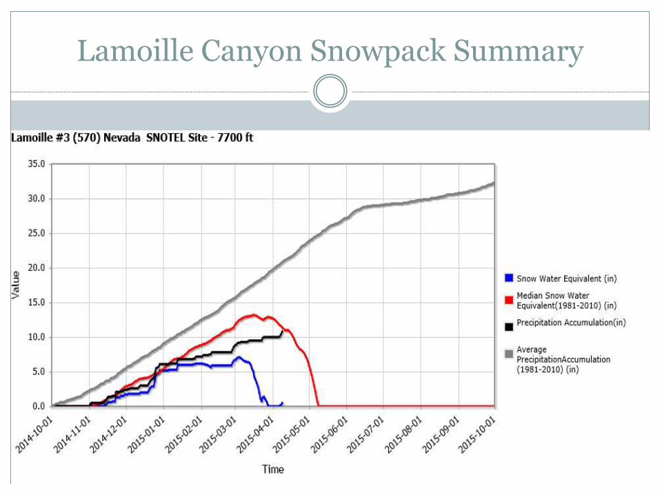
Lamoille Canyon Snowpack Summary

Departure from Average Greenness
2015 2014 2012

Temperature Precipitation
Recent Weather Trends(past 60 days)

Water Year Precipitation
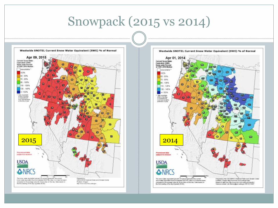
Snowpack (2015 vs 2014)
2015 2014

Drought Conditions (2015 vs 2014)
2015 20142015 2014
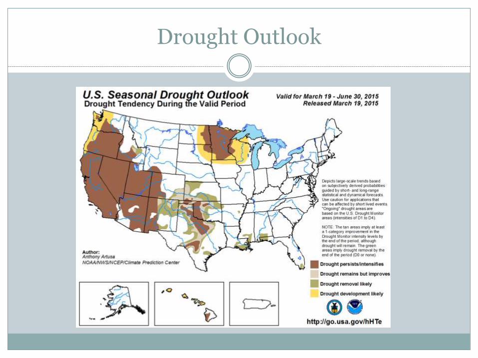
Drought Outlook

Recent Weather Trend Summary
Average temperatures have remained above normal across the GB.
Precipitation remained well below normal over the central portion of the GB and near normal in some areas of southern ID and southern UT.
The snowpack continued to decline to 2-25% over the Sierra and Nevada, and 40-65% over ID/UT.
Extreme to exceptional drought continues over the western half of NV and CA with moderate drought over much of the rest of the GB. The drought has expanded over southern ID/northern UT with some areas seeing severe-extreme drought.
The drought conditions are expected to persist through the end of July 2015 across most the GB.

Fuels
Green-up ongoing across the GB, and started early in 2015.
Despite the earlier start to green-up, the curing of the fuels may still occur on time considering the transition to a more showery pattern in the spring.
A return to a more active weather pattern will allow green-up to continue through April and even possibly into May.
Spring rains will likely bring more grass growth to the GB than in recent years.
The higher elevations are still extremely dry after another very poor year for snowpack, especially over the western half of the GB.

Temperature Precipitation
CPC 8 – 14 day Climate Outlooks

Temperature Precipitation
Long Term CPC Climate Outlooks
May - July May - July

Long Term PS Weather Outlook

Current Fire Danger
Fuel Moisture
Fuel Loading
Recent Weather Trends
Currently low Fire Potential in all areasdue to cooler temperatures and green-upand periodic winter precipitation.

April and May Fire Potential Outlook Normal large fire potential (little to no large
fire activity) through April/May, and maybe into June in some areas.
The weather pattern is shifting at the beginning of April to a more active pattern (more frequent low pressure troughs moving through the GB bringing cooler temperatures, wind and precipitation) and this should keep a lid on significant fire potential in most areas through April and May.
There is still a potential of significant larger fires during strong wind events after prolonged periods of drier weather at times during April and May, but these concerns would be of shorter duration.

June and July Fire Potential Outlook
Large fire potential is expected to increase by June/July in the higher elevations and over the Sierra, western NV into ID.
How early in June this increase takes place will depend on the weather pattern, and this time there still is a threat for cooler troughs bringing precipitation in early June.
Spring precipitation will be monitored closely as this will promote grass growth, which is likely to be more than recent years.
Any spring precipitation will not be enough to alleviate any of the drought over the western half of the Great Basin.
The higher elevations still will be a concern again this year due to drought and very low winter snowpack again.

Anticipated Exceptions to a ‘normal’ start to fire season for 2015
‘Below Normal’ across southern/southeast Utah through May and possibly into June…which would be a delayed start.
‘Above Normal’ over the Sierra and far western Nevada and southwest and central for June/July…which would be earlier than normal in June, especially in the higher elevations.
Potential ‘Above Normal’ across much of the central and northern Great Basin for July/August.

New GBCC
EGB and WGB merged as of January 1, 2015 New physical center located in SLC (renovating new
facility underway) All GBCC located in center in SLC, except Gina McGuire
(meteorologist) will remain at the NVSO in Reno, NV. New GBCC website up and running, but still not
complete – continue to look for updates. Several positions in the new center still vacant. (center
manager, logistics (including a coordinator position), meteorologist, admin, webmaster/GIS)
All requests go through SLC office. New PS products.

Great Basin Meteorologists located in Reno and Salt Lake City
Great Basin Meteorologists
Gina McGuire (Reno)– [email protected]
Shelby Law (SLC) - [email protected]
Nanette Hosenfeld (SLC)– [email protected]
Predictive Services contact phone number in SLC – 801-531-5320 (Shelby and Nanette)
Predictive Services contact phone number in Reno– 775-861-6650 (Gina)
Detailed monthly/seasonal outlooks are available on the GACC websites.

Home Page Outlooks Page
New GBCC Website

One GBCC Webcast
Multi-Media briefing for the entire GBCC
Will focus on the main areas of concern
Focus is on days 1-3, with extended outlook to 7 days (or longer if significant changes are on the horizon)

National Seasonal OutlookOne GBCC Local Seasonal Outlook
No Change to National Seasonal Outlook


New ERC Map

Current Original PS Products
Multi-Media Webcast - updated twice a week (daily during fire season)
Monthly/Seasonal 4 Month Outlook – updated at the beginning of each month (PDF, PowerPoint, Multi-Media Webcast)
7-Day Significant Fire Potential Product (issued M-F in May, and daily during fire season)
The End
S E N D Q U E S T I O N S / C O M M E N T ST O
G I N A M C G U I R E , S H E L B Y L A W , O R N A N E T T E H O S E N F E L D – G B C C
G M C G U I R E @ B L M . G O VS L A W @ B L M . G O V
N H O S E N F E L D @ B L M . G O V