great barrier reef marine park basis for zoning … · for further information on the draft zoning...
TRANSCRIPT
Great Barrier Reef Marine Park
CONSULTATION DRAFT
BASIS FOR ZONING
DECISIONSREPORT
Great Barrier Reef Marine Park
BASIS FOR ZONING DECISIONS REPORT
CONSULTATION DRAFT
June 2003
DRAFT ONLY – Subject to change following Public Consultation
Published by the Great Barrier Reef Marine Park Authority, June 2003 © Great Barrier Reef Marine Park Authority ISBN 1 876945 23 0
2-68 Flinders Street PO Box 1379 TOWNSVILLE QLD 4810 Phone: (07) 4750 0700 Fax: (07) 4772 6093
DRAFT ONLY – Subject to change following Public Consultation
Draft Great Barrier Reef Marine Park Zoning Plan 2003
BASIS FOR ZONING DECISIONS REPORT
DRAFT
June 2003
Describing the issues, public comments and management responses for the proposed zoning
DRAFT ONLY – Subject to change following Public Consultation
Further information For further information on the Draft Zoning Plan, the Basis for Zoning document, and information papers on key issues, or to make a submission please refer to the Great Barrier Reef Marine Park Authority website www.gbrmpa.gov.au or contact one of the following offices: Great Barrier Reef Marine Park Authority 2-68 Flinders Street PO Box 2184 TOWNSVILLE QLD 4810 Phone: (07) 4750 0700 Freecall 1800 990 177
John Gorton Building King Edward Terrace PARKES ACT 2600 PO Box 791 CANBERRA ACT 2601 Phone: (02) 6274 1922

DRAFT ONLY – Subject to change following Public Consultation
Table of Contents Foreword .......................................................................................................................... i 1 Summary ................................................................................................................. 1 2 Introduction ............................................................................................................ 3
2.1 The Great Barrier Reef Marine Park............................................................ 3 2.2 Statement of management intent................................................................. 5 2.3 Rezoning the Marine Park ............................................................................ 6
2.3.1 Planning and management of the Marine Park................................. 6 2.3.2 Reviewing current Zoning Plans ......................................................... 6 2.3.3 The process for rezoning the Marine Park ......................................... 7 2.3.4 Zoning the new coastal sections of the Marine Park ........................ 8 2.3.5 Amalgamating the Sections of the Marine Park................................ 9
3 Guiding principles for the Representative Areas Program ........................... 11 3.1 Bioregions...................................................................................................... 11 3.2 Biophysical Operational Principles ........................................................... 12 3.3 Social, Economic, Cultural and Management Feasibility Operational Principles................................................................................................................... 13 3.4 Submissions .................................................................................................. 13 3.5 Known uses................................................................................................... 13
4 Zoning.................................................................................................................... 14 4.1 Reef-wide changes to zoning ..................................................................... 14
4.1.1 Zones...................................................................................................... 14 4.1.2 Definitions............................................................................................. 15 4.1.3 Zone boundaries .................................................................................. 15
4.2 Zone objectives ............................................................................................. 16 4.3 Activities allowed in zones......................................................................... 18
5 Overview of submissions and other sources of information......................... 19 5.1 Comparison between previous and current zoning processes ............. 19 5.2 Community participation process ............................................................. 19 5.3 Submission analysis..................................................................................... 20
5.3.1 Method of analysis............................................................................... 21 5.4 Other sources of information ..................................................................... 22
6 Issues...................................................................................................................... 23 6.1 Conservation and biodiversity protection ............................................... 23
6.1.1 Summary of submissions.................................................................... 23 6.1.2 Responses and outcomes .................................................................... 23
6.2 Recreational fishing ..................................................................................... 24 6.2.1 Summary of submissions.................................................................... 24 6.2.2 Responses and outcomes .................................................................... 24
6.3 Commercial fishing...................................................................................... 25 6.3.1 Summary of submissions.................................................................... 25 6.3.2 Responses and outcomes .................................................................... 25
6.4 Tourism ......................................................................................................... 26 6.4.1 Summary of submissions.................................................................... 26 6.4.2 Responses and outcomes .................................................................... 26
6.5 Recreational usage sector submissions ..................................................... 27

DRAFT ONLY – Subject to change following Public Consultation
6.5.1 Summary of submissions.................................................................... 27 6.5.2 Responses and outcomes .................................................................... 28
6.6 Indigenous issues......................................................................................... 28 6.6.1 Summary of submissions.................................................................... 28 6.6.2 Responses and outcomes .................................................................... 28
6.7 GBR coastal community residents............................................................. 29 6.7.1 Summary of submissions.................................................................... 29 6.7.2 Responses and outcomes .................................................................... 29
6.8 Research and monitoring............................................................................ 29 6.8.1 Summary of submissions.................................................................... 29 6.8.2 Responses and outcomes .................................................................... 30
6.9 Compliance, surveillance and enforcement............................................. 30 6.9.1 Summary of submissions.................................................................... 30 6.9.2 Responses and outcomes .................................................................... 30
6.10 Commercial shipping and ports ................................................................ 31 6.10.1 Summary of submissions.................................................................... 31 6.10.2 Responses and outcomes .................................................................... 31
6.11 Other issues................................................................................................... 32 6.11.1 Summary of submissions.................................................................... 32 6.11.2 Responses and outcomes .................................................................... 32
7 Proposed management changes ........................................................................ 34 7.1 Recreational fishing activities..................................................................... 34
7.1.1 Line fishing ........................................................................................... 35 7.1.2 Spearfishing .......................................................................................... 35 7.1.3 Limited collecting................................................................................. 36 7.1.4 Protected species .................................................................................. 36
7.2 Commercial fishing activities..................................................................... 36 7.2.1 Line fishing and trolling...................................................................... 38 7.2.2 Commercial dive-based fisheries....................................................... 38 7.2.3 Bait netting ............................................................................................ 38 7.2.4 Commercial crabbing and commercial netting ............................... 38 7.2.5 Trawling ................................................................................................ 39 7.2.6 Fishing gear stowed or secured requirements................................. 39 7.2.7 Protected species .................................................................................. 39 7.2.8 Aquaculture .......................................................................................... 39
7.3 Biodiversity conservation ........................................................................... 40 7.3.1 Protected species .................................................................................. 40 7.3.2 Dugong protection............................................................................... 40
7.4 Designated Areas ......................................................................................... 41 7.4.1 Special Management Areas ................................................................ 42 7.4.2 Shipping Areas ..................................................................................... 43
7.5 Shipping and related issues........................................................................ 44 7.6 Cruise Ship Anchorage Areas .................................................................... 44 7.7 Scientific research......................................................................................... 45
7.7.1 Zoning for recognised areas of high research activity.................... 45 7.7.2 Zoning provisions and permits.......................................................... 46
7.8 Traditional use of marine resources.......................................................... 47
DRAFT ONLY – Subject to change following Public Consultation
7.9 Remote Natural Area and No Structures Subzone ................................. 48 8 Zone placement, examples and basis for zoning............................................. 49
8.1 Preservation Zone ........................................................................................ 49 8.1.1 Objective................................................................................................ 49 8.1.2 Placement of the Preservation Zone.................................................. 50 8.1.3 Details of each Preservation Zone within the Draft Zoning Plan. 50
8.2 Marine National Park Zone........................................................................ 52 8.2.1 Objectives .............................................................................................. 52 8.2.2 Placement of the Marine National Park Zone.................................. 52 8.2.3 Details of each Marine National Park Zone within the Draft Zoning Plan........................................................................................................... 54
8.3 Buffer Zone ................................................................................................... 70 8.3.1 Objectives .............................................................................................. 70 8.3.2 Placement of the Buffer Zone ............................................................. 70 8.3.3 Examples of Buffer Zone within the Draft Zoning Plan ................ 70
8.4 Scientific Research Zone ............................................................................. 71 8.4.1 Objectives .............................................................................................. 71 8.4.2 Placement of the Scientific Research Zone ....................................... 71 8.4.3 Details of each Scientific Research Zone within the Draft Zoning Plan 72
8.5 Conservation Park Zone ............................................................................. 73 8.5.1 Objectives .............................................................................................. 73 8.5.2 Placement of the Conservation Park Zone ....................................... 73 8.5.3 Details of each Conservation Park Zone within the Draft Zoning Plan 75
8.6 Habitat Protection Zone.............................................................................. 80 8.6.1 Objectives .............................................................................................. 80 8.6.2 Placement of the Habitat Protection Zone........................................ 80 8.6.3 Specific examples of Habitat Protection Zone within the Draft Zoning Plan........................................................................................................... 81
8.7 General Use Zone......................................................................................... 81 8.7.1 Objective................................................................................................ 81 8.7.2 Placement of the General Use Zone .................................................. 82
8.8 Commonwealth Islands Zone .................................................................... 82 8.8.1 Objectives .............................................................................................. 82 8.8.2 Placement of the Commonwealth Island Zone ............................... 82 8.8.3 Specific examples of Commonwealth Islands Zone within the Draft Zoning Plan ................................................................................................ 82
8.9 New Coastal Area Zoning .......................................................................... 83 8.9.1 Shadwell Section .................................................................................. 83 8.9.2 Heathlands Section .............................................................................. 84 8.9.3 Margaret Bay Section........................................................................... 85 8.9.4 Indian Bay Section ............................................................................... 87 8.9.5 Fair Cape Section.................................................................................. 88 8.9.6 Weymouth Section............................................................................... 89 8.9.7 Night Island Section ............................................................................ 90 8.9.8 Claremont Section................................................................................ 91
DRAFT ONLY – Subject to change following Public Consultation
8.9.9 Bathurst Head Section......................................................................... 92 8.9.10 Ninian Bay Section............................................................................... 94 8.9.11 Cape Flattery Section........................................................................... 95 8.9.12 Cooktown Section ................................................................................ 96 8.9.13 Wet Tropics Coast Section .................................................................. 98 8.9.14 Clump Point Section .......................................................................... 101 8.9.15 Mission Beach Section ....................................................................... 102 8.9.16 Halifax Bay Section ............................................................................ 103 8.9.17 Cleveland Bay Section ....................................................................... 105 8.9.18 Burdekin Section ................................................................................ 106 8.9.19 Edgecumbe Section............................................................................ 107 8.9.20 Airlie Section....................................................................................... 108 8.9.21 Repulse Bay Section........................................................................... 110 8.9.22 Sandringham Section......................................................................... 111 8.9.23 Broad Sound Section.......................................................................... 113 8.9.24 Farnborough Section ......................................................................... 115 8.9.25 Keppel Bay Section ............................................................................ 116 8.9.26 Curtis Island Section.......................................................................... 117 8.9.27 Boyne Section...................................................................................... 118 8.9.28 Bustard Bay Section ........................................................................... 119
8.10 Achievement of the Biophysical Operational Principles...................... 121 8.10.1 Principle 1 & 2: Minimum size and larger versus smaller ........... 121 8.10.2 Principle 3: Sufficient no-take areas ................................................ 121 8.10.3 Principle 4: Do not split reefs between zones ................................ 121 8.10.4 Principles 5 & 6: Represent at least 20% of each reef and non-reef bioregion.............................................................................................................. 121 8.10.5 Principles 7 & 8: Represent cross-shelf and latitudinal diversity and minimum amount of each community type and physical type .......... 121 8.10.6 Principle 9: Maximise use of environmental information............ 121 8.10.7 Principle 10: Include biophysically special/unique places.......... 122 8.10.8 Principle 11: Existing sea and adjacent land uses ......................... 122
8.11 Special and unique sites ............................................................................ 123 9 References ........................................................................................................... 131 10 Appendicies .................................................................................................... 136
10.1 Description of reef bioregions. ................................................................. 136 10.2 Description of non-reef bioregions.......................................................... 138 10.3 New coastal areas map.............................................................................. 141

DRAFT ONLY – Subject to change following Public Consultation
Tables Table 1: Zone name changes...................................................................................... 14 Table 2. Zone Objectives ............................................................................................ 17 Table 3. Activities allowed in Zones ........................................................................ 18 Table 4: Recreational fishing activities in Zones .................................................... 34 Table 5: Commercial fishing activities in Zones..................................................... 37 Table 6: Research permit requirements for each Zone. ......................................... 46 Table 7: List of symbols and associated attributes ................................................. 49 Table 8: Change in the total area of PZ for the Draft Zoning Plan. ...................... 50 Table 9: Change in the total area of MNPZ for the Draft Zoning Plan. ............... 52 Table 10: Change in the total area of BZ for the Draft Zoning Plan. .................... 70 Table 11: Change in the total area of SRZ for the Draft Zoning Plan. .................. 71 Table 12: Change in the total area of CPZ for the Draft Zoning Plan. ................. 73 Table 13: Change in the total area of HPZ for the Draft Zoning Plan. ................. 80 Table 14: Change in the total area of GUZ for the Draft Zoning Plan.................. 81 Table 15: Achievement of the BOPs ........................................................................ 122 Table 16: Special unique sites and their conservation values.............................. 125
Figures and Maps Figure 1: Zoning process.............................................................................................. 7 Map 1: Amalgamated Sections of the Marine Park and Management Areas ..... 10 Figure 2: Submissions received for various GBRMPA zoning processes........... 19 Figure 3: Number of submissions received by geographical region.................... 21
DRAFT ONLY – Subject to change following Public Consultation
i
Foreword This ‘Basis for Zoning’ document sets out the background for the development of the Draft Zoning Plan for the Great Barrier Reef Marine Park, including the new coastal sections recently added to the Marine Park. The document summarises the wide range of information that assisted the Great Barrier Reef Marine Park Authority to make the zoning decisions shown in the Draft Zoning Plan. It includes a summary of the issues raised during the first formal community participation phase (7 May to 7 August 2002), commenting on the proposal to rezone the Great Barrier Reef Marine Park. All submissions have been considered in accordance with Section 32 of the Great Barrier Reef Marine Park Act 1975. I would particularly like to thank all those who have contributed to this Draft Zoning Plan including users of the Marine Park, Indigenous Australians, interested members of the public, researchers and departmental officers. I now invite all interested persons, community groups or agencies to make written submissions on the Draft Zoning Plan during the second formal community participation phase. All such submissions should be received at the Great Barrier Reef Marine Park Authority no later than Monday 4 August 2003. Following the consideration of all submissions received on the Draft Zoning Plan, the Plan will be revised and then submitted by the Great Barrier Reef Marine Park Authority to the Minister for Environment and Heritage for tabling in both Houses of the Federal Parliament.
Virginia Chadwick Chair
DRAFT ONLY – Subject to change following Public Consultation
1
1 Summary The Great Barrier Reef Marine Park Act 1975 (‘the Act’) provides for the establishment, control, care and development of the Great Barrier Reef Marine Park (‘the Marine Park’). The Act confers responsibility for the management of the Marine Park upon the Great Barrier Reef Marine Park Authority (‘the GBRMPA’). The GBRMPA also plays a major role in the management of the Great Barrier Reef World Heritage Area (‘the GBRWHA’), in accordance with the Environment Protection and Biodiversity Conservation Act 1999. In managing the Marine Park and its responsibilities for the World Heritage Area, the GBRMPA also implements Federal Government policies arising from such international obligations as the:
• World Heritage Convention 1972; • Convention on Conservation of Migratory Species of Wild Animals 1979;
and • Convention on Biological Diversity 1992.
Against this background, the Draft Great Barrier Reef Marine Park Zoning Plan 2003 (‘the Draft Zoning Plan’) has been developed as the primary planning instrument for the conservation and management of the Marine Park, in accordance with Section 32(7) of the Act, for:
• the conservation of the Great Barrier Reef; • the regulation of the wise use of the Marine Park so as to protect the
Great Barrier Reef while allowing the reasonable use of the Great Barrier Reef Region;
• the regulation of activities that exploit the resources of the Great Barrier Reef Region so as to minimize the effect of those activities on the Great Barrier Reef;
• the reservation of some areas of the Great Barrier Reef for its appreciation and enjoyment by the public; and
• the preservation of some areas of the Great Barrier Reef in its natural state undisturbed by man except for the purposes of scientific research.
A notice of intent to prepare a Draft Zoning Plan for the Marine Park was issued on 7 May 2002 and the public was invited to provide written submissions to assist in developing a Draft Zoning Plan until 7 August 2002. Analysis of the 10,190 submissions received by the GBRMPA during the first formal phase of community participation highlighted a number of major issues to be considered in the Draft Zoning Plan. These included:
• protection of natural and cultural values; • maintenance of recreational fishing access; • maintenance of commercial fishing access;
DRAFT ONLY – Subject to change following Public Consultation
2
• tourism; • indigenous values; • shipping; • defence; • research; • complementary zoning; and • compliance, surveillance and enforcement.
The Draft Zoning Plan was developed after consideration of available natural resource, social, economic and cultural information, management issues and public input. It builds on the framework established by previous Zoning Plans for the Far Northern, Cairns, Central, Mackay/Capricorn and Gumoo Woojabuddee Sections to provide a single consistent Zoning Plan for the entire Marine Park. The Draft Zoning Plan also provides zoning for the 28 new coastal sections, which were included in the Marine Park between 2000 and 2001. Many of the provisions of previous Zoning Plans have been updated in the Draft Zoning Plan. The Draft Zoning Plan also provides for the description of zone boundaries though a process of coordinate-based mapping. It is believed that in addition to the conservation benefits, these changes will provide for a simpler and more consistent basis for the management of activities within the Marine Park. The Draft Zoning Plan was released on 2 June 2003 and is accompanied by a variety of background documentation, including this ‘Basis for Zoning’ document. The community and any interested persons are now invited to make comments on the Draft Zoning Plan in accordance with the Act. Submissions must be received by GBRMPA by the close of business on Monday 4 August 2003.

DRAFT ONLY – Subject to change following Public Consultation
3
2 Introduction This document details the basis of zoning decisions for the Marine Park. Background information on the Draft Zoning Plan for the Marine Park is provided, together with a description of the proposals presented for public comment in the Draft Zoning Plan. An overview of the issues raised in submissions during the first formal phase of public input is included. This document also contains GBRMPA’s responses to comments on the proposal to re-zone the Marine Park and explains how the specific matters have been addressed in the Draft Zoning Plan. This document should be read in conjunction with the Draft Zoning Plan and associated Draft Zoning Maps.
2.1 The Great Barrier Reef Marine Park The Great Barrier Reef Marine Park comprises the world’s largest system of coral reefs, together with inter-reefal lagoons, seagrasses, mangroves and waters up to 100-300 kilometres offshore, beyond the edge of the continental shelf. Stretching 2300km along Australia’s north-eastern coast, from the tip of Cape York Peninsula, south to Rules Beach near Bundaberg, the Marine Park covers 345,400km2. Due to its national and international importance, the Great Barrier Reef is both a Marine Park and World Heritage Area. The Marine Park was created as a multiple use Marine Park by the Act, which provides for the establishment, control, care and development of the Great Barrier Reef. The Great Barrier Reef was also inscribed on the World Heritage List in October 1981 meeting all four natural World Heritage criteria. It is the largest World Heritage Area and is a unique area of outstanding universal value. The Marine Park supports a high degree of biological diversity due to the variety of ecosystems present and the immense scale of the area. Contrary to its name, the Great Barrier Reef is not one long continuous reef, but a complex of about 2900 coral reefs, 900 islands and other associated and interconnected marine habitats. Diversity is high and includes approximately 1500 species of fish, 350 species of hard corals, over one-third of the world’s soft coral and sea-pen species, 5000 mollusc species, six of the world’s seven species of marine turtles and more than 30 species of marine mammals. The Marine Park represents an important area for the conservation of many rare or threatened species. It provides important habitat and breeding areas for marine turtles, dugong, seabirds, humpbacks and other whales. This extraordinary biodiversity and the interconnectedness of species and habitats makes the Great Barrier Reef and the surrounding areas one of the richest and most complex natural systems on earth. While coral reef, mangrove

DRAFT ONLY – Subject to change following Public Consultation
4
and seagrass habitats occur elsewhere on the planet, no other World Heritage Area contains such biodiversity. As the world’s largest coral reef ecosystem, it is also a critical global resource. The reefs and the surrounding areas are also significant for Australia's Indigenous people, the Aboriginals and Torres Strait Islanders. It has provided the basis for sustenance and been of cultural significance for thousands of years. Since European settlement in the 19th Century, use of the north Queensland coast has grown and intensified to include commercial fishing, tourism, shipping, scientific research and recreational pursuits such as boating, fishing and diving. During this period there has also been significant urban and rural development of the mainland adjacent to the Marine Park. The Great Barrier Reef today supports a major part of Australia's economy with an estimated economic worth of more than A$1 billion per annum. Tourism provides about A$650 million per annum; commercial fishing around A$150 million per annum and the large recreational fishing and recreational boating sector is worth about A$120 million per annum. The Commonwealth and State Governments have a cooperative and integrated approach to management of the Marine Park built on an agreement signed in 1979. The GBRMPA is the Federal agency responsible for overall planning and management. Field-based, day-to-day management (DDM) of the Marine Park is jointly funded and conducted primarily by Queensland agencies within programs and guidelines approved by the GBRMPA. DDM activities, undertaken mainly by officers of the Queensland Parks and Wildlife Service (QPWS), include enforcement, surveillance, monitoring and education, as well as the management of adjacent Queensland Marine Parks and island National Parks. Other Queensland and Commonwealth agencies also involved in DDM include the Queensland Boating and Fisheries Patrol, the Queensland Water Police, the Australian Customs Service (Coastwatch) and the Australian Maritime Safety Authority. The cooperative level of joint management that has now developed between the two levels of government for the Reef, and the complementary legislation for most adjoining State waters, has produced an effective management regime that assists all Reef users. The Representative Areas Program implements a current policy of the Federal Government:
‘During the next parliament, a Coalition government will … progress the representative areas process, ensuring that all habitat types in the Great Barrier Reef are adequately protected;…..’ (‘A Better Environment’, Coalition Platform, October 2001)
DRAFT ONLY – Subject to change following Public Consultation
5
Queensland Government documents also refer to RAP:
‘The State Government will support the Great Barrier Reef Marine Park representative areas program to increase protection of biodiversity by increasing the number of habitats included in the no-take zones. It will develop and implement a strategy to protect marine biodiversity and threatened species generally including extending protection under the Nature Conservation Act.’ (‘Valuing the environment’; State Budget 2001-02).
2.2 Statement of management intent The Draft Zoning Plan is the primary planning instrument for the conservation and management of the Marine Park. Subsection 32(7) of the Act provides that, in preparing a Zoning Plan, the GBRMPA must have regard to a number of objects including the conservation of the Great Barrier Reef, the regulation of the use of the Marine Park so as to protect the Great Barrier Reef, the reservation of some areas for appreciation and enjoyment by the public, and the preservation of some areas in the natural state. The Draft Zoning Plan also takes into account the Great Barrier Reef World Heritage values and the principles of ecologically sustainable development. In conjunction with other management mechanisms, the Draft Zoning Plan aims to protect and conserve the biodiversity of the Great Barrier Reef ecosystem within a network of ‘no-take zones’, while providing opportunities for the ecologically sustainable use of, and access to, the Great Barrier Reef Marine Park by current and future generations. In addition to protecting ‘representative’ examples of the entire range of habitats, the Draft Zoning Plan also provides for the protection of other areas of high conservation value by assigning protective zoning to other important habitats, breeding and spawning areas as well as other special or unique sites. The Draft Zoning Plan expressly acknowledges the rights and interests of Indigenous Australians in the Marine Park by providing for the management of the traditional use of marine resources, including traditional hunting, in accordance with Aboriginal and Torres Strait Islander custom and tradition. The contribution of scientific research to the management and understanding of the Marine Park is also acknowledged in the Draft Zoning Plan, which provides for the management of research in the Marine Park. This includes a system of Scientific Research Zones (SRZ) to facilitate research around scientific research stations.
DRAFT ONLY – Subject to change following Public Consultation
6
2.3 Rezoning the Marine Park
2.3.1 Planning and management of the Marine Park The Marine Park is a multiple-use park, where all reasonable uses are allowed. However, some locations within the Marine Park need to be set aside free from extractive activities (like a national park on land), while potentially conflicting activities (such as fishing and diving activities) need to be separated in other areas. To ensure all such areas are appropriately managed, the Marine Park has been divided into zones. Zoning establishes the foundation for managing use while protecting the Marine Park. Accordingly, Zoning Plans apply to all users of the Marine Park. All other management tools complement Zoning Plans. The Draft Zoning Plan divides the Marine Park into eight zones (Section 4.1.1) and sets out the purposes for which each zone may be used or entered, either:
• ‘as of right’ (without a permission); or • with the written permission of the GBRMPA.
The Draft Zoning Plan also provides for the management of remote natural areas of the Marine Park, and the designation of shipping and special management areas that may be applied to address management objectives in particular areas, as well as additional purposes for which zones may be used or entered. Sections 7.4 (Designated Areas) and 8 (Zone Placement, examples and basis for zoning) provide detailed information on Designated Areas and the zone types, including examples of that zone found within the Draft Zoning Plan. Zoning Plans are developed and reviewed in consultation with user and interest groups, Indigenous people, the scientific community and the general public.
2.3.2 Reviewing current Zoning Plans There are currently five Zoning Plans in place within the Marine Park:
• Central Section (in operation since October 1987) • Mackay/Capricorn Section (in operation since August 1988) • Cairns Section (in operation since April 1992) • Far Northern Section (in operation since April 2002) • Gumoo Woojabuddee Section (in operation since December 2002)
Given that the current zoning plans have been progressively developed over the last 15 years, some of the terms, management provisions and zone names differ slightly between various Sections. This current rezoning process will see the development of a single Zoning Plan for the Marine Park and will remove inconsistencies between the five Sections.
DRAFT ONLY – Subject to change following Public Consultation
7
The most fundamental aspect of the rezoning process is the implementation of the Representative Areas Program (RAP). RAP is being undertaken because the current zoning does not adequately protect the range of biodiversity now known to exist across the Great Barrier Reef Marine Park. The RAP aims to protect ‘representative’ examples of the entire range of habitats, plants and animals in the Marine Park while minimising impacts on existing uses. By ensuring the future of the Great Barrier Reef ecosystem, the GBRMPA seeks to maintain lifestyles, ensure economic prosperity and continue to allow equitable access to the natural resources of the Marine Park in perpetuity. RAP will protect the immense variety of biodiversity in the Marine Park for the benefit of all. Section 3 (Guiding principles for RAP) provides additional information on the RAP.
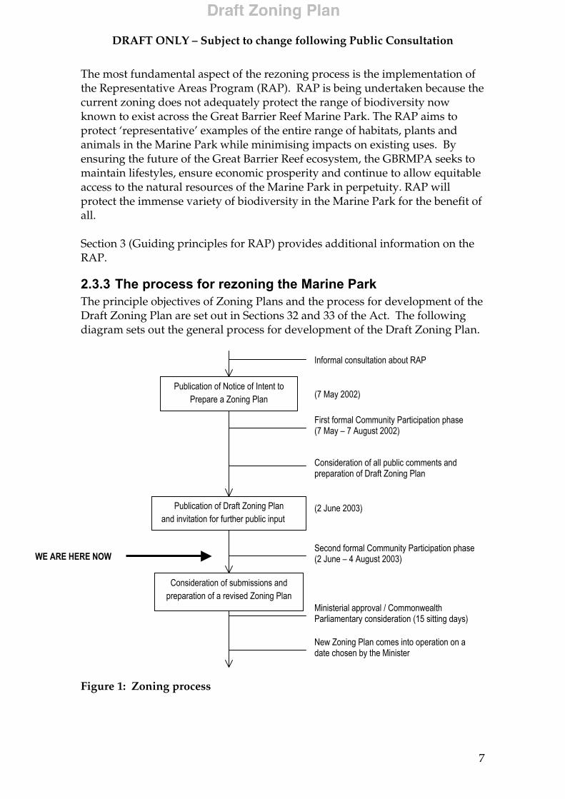
2.3.3 The process for rezoning the Marine Park The principle objectives of Zoning Plans and the process for development of the Draft Zoning Plan are set out in Sections 32 and 33 of the Act. The following diagram sets out the general process for development of the Draft Zoning Plan.
Figure 1: Zoning process
Publication of Notice of Intent to Prepare a Zoning Plan
Publication of Draft Zoning Plan and invitation for further public input
Consideration of submissions and preparation of a revised Zoning Plan
Informal consultation about RAP
WE ARE HERE NOWSecond formal Community Participation phase (2 June – 4 August 2003)
(2 June 2003)
Consideration of all public comments and preparation of Draft Zoning Plan
First formal Community Participation phase (7 May – 7 August 2002)
(7 May 2002)
Ministerial approval / Commonwealth Parliamentary consideration (15 sitting days)
New Zoning Plan comes into operation on a date chosen by the Minister
DRAFT ONLY – Subject to change following Public Consultation
8
A notice of intent to prepare a Draft Zoning Plan was issued on 7 May 2002 and the public was invited to provide input until 7 August 2002. The original proposal covered the four main sections of the Marine Park (the Far Northern, Cairns, Central and Mackay/Capricorn Sections) and the 28 new coastal sections. The Gumoo Woojabuddee Section Zoning Plan had not been finalised as at May 2002 and a subsequent public notice was issued on 10 January 2003 to provide that the area of the Draft Zoning Plan would be extended to include the Gumoo Woojabuddee Section. Over 10,000 submissions were received commenting on the proposal to develop a Draft Zoning Plan for the Marine Park. For more information, refer to Section 5 (Overview of submissions). The GBRMPA released the Draft Zoning Plan on 2 June 2003 and the community is invited to provide written comments by the close of business on Monday 4 August 2003. Following consideration of submissions received in the second phase of community participation, the Draft Zoning Plan will be revised by the GBRMPA and submitted to the Minster for Environment and Heritage for tabling in both Houses of Federal Parliament.
2.3.4 Zoning the new coastal sections of the Marine Park In January 1999, the Commonwealth Minister for Environment and Heritage announced that certain coastal areas previously excluded from the Marine Park would now be included. These areas were excluded when the Marine Park was first declared because of concerns about their potential for industrial or port developments. The addition of the 28 new coastal areas to the Marine Park has occurred in a staged process between August 2000 and July 2001. Some small areas of State waters around the major ports/urban centres remain excluded from the Great Barrier Reef Marine Park. Under the Act, it is a statutory requirement that Zoning Plans be prepared for the new areas as soon as practicable after their proclamation as Sections of the Marine Park. This is being done in parallel with the implementation of the RAP. The zoning of these areas follows the same process described above in Figure 1 and will allow for multiple use of these areas. Section 8.9 (New Coastal Area Zoning) provides detailed information on proposed zoning for each of the new coastal areas. Until a Zoning Plan is in operation, the new areas remain unzoned areas of the Marine Park. Under Section 38F of the Act, certain activities are prohibited in unzoned areas unless authorised by permission from the GBRMPA. Examples include:
• building or constructing major structures; • carrying out works such as reclamation and beach protection; and • demolition or removal of structures.

DRAFT ONLY – Subject to change following Public Consultation
9
Recreational and commercial fishing activities, and general use of the Marine Park are permitted in unzoned areas. Areas above the mean low water mark and intertidal waters of Queensland are not part of the Marine Park. However, they may be subject to existing Queensland Marine Parks zoning provisions and other State legislation.
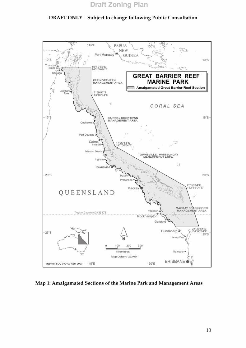
2.3.5 Amalgamating the Sections of the Marine Park Since the declaration of the first Section of the Marine Park in 1983, the Marine Park has been progressively increased to its present size by the addition of new Sections. The Far Northern Section, the Cairns Section, the Central Section and the Mackay/Capricorn Section were declared between 1983 and 1987. In 1998, the Gumoo Woojabuddee Section was incorporated into the Marine Park, and as described above, a further 28 new coastal Sections were incorporated as recently as 2001. The Draft Zoning Plan applies to all Sections. For clarity, and to facilitate coordinate based zoning, the Sections will be amalgamated to form the ‘Amalgamated Great Barrier Reef Section’ (the AGBR Section). For administrative purposes, the AGBR Section will be divided into four management areas:
• the Far Northern Management Area; • the Cairns/Cooktown Management Area; • the Townsville/Whitsundays Management Area; and • the Mackay/Capricorn Management Area.
Although these areas have no legislative effect, they approximate the areas of the previous four main Sections and provide a basis for the regional management of the Marine Park. Further sub-areas or regions may also be identified for particular management purposes. Map 1 shows the location and extent of the Amalgamated Great Barrier Reef Section and the four Management Areas
DRAFT ONLY – Subject to change following Public Consultation
10
Map 1: Amalgamated Sections of the Marine Park and Management Areas
DRAFT ONLY – Subject to change following Public Consultation
11
3 Guiding principles for the Representative Areas Program
The objective of the RAP is to increase the protection of biodiversity within the Marine Park through increasing the extent of Marine National Park Zones, (MNPZ), also called Green Zones or ‘no-take’ zones, to:
• maintain biological diversity of the ecosystem, habitat, species, population and genes;
• allow species to evolve and function undisturbed; • provide an ecological safety margin against human-induced disasters; • provide a solid ecological base from which threatened species or habitats
can recover or repair themselves; and • maintain ecological processes and systems.
To assist the RAP, two independent steering committees were formed to provide expert advice to the GBRMPA about the:
• biological and physical aspects of the Great Barrier Reef; and • social, economic, cultural and management feasibility aspects of human
use of the Marine Park. A summary of the Biophysical Operational Principles and the Social, Economic, Cultural and Management Feasibility Operational Principles developed by the committees is given below (Sections 3.2 and 3.3). These principles were applied as far as practicable to the selection of new no-take areas and helped to protect biodiversity while maximising positive and minimising negative impacts on local communities and stakeholders.
3.1 Bioregions These expert committees helped with the process whereby the biological and physical diversity of the GBRWHA was classified into 70 ‘bioregions’ (30 reef bioregions and 40 non-reef bioregions). Bioregions have habitats, communities (e.g. areas of seagrass) and physical features (e.g. sediment type, depth) that are more similar within the bioregion than those occurring in other bioregions. The bioregions were developed with panels of experts, using the best available information. More than 40 layers of data were used, compiled from years of research. Lists describing each bioregion are at Appendix 10.1 (Reef bioregions) and Appendix 10.2 (Non-reef bioregions) and a map of all bioregions is available on the web at http://www.gbrmpa.gov.au/corp_site/key_issues/conservation/rep_areas/documents/bioregions_2001_06.pdf
DRAFT ONLY – Subject to change following Public Consultation
12
3.2 Biophysical Operational Principles The independent Scientific Steering Committee (SSC), comprising of scientists with expertise in the Great Barrier Reef Region, provided advice to the GBRMPA on scientific issues relevant to the selection of representative areas of biodiversity. The following Biophysical Operational Principles (BOPs) were recommended by the SSC to guide the establishment of a new network of no-take areas that would achieve the objectives of the RAP. The following principles have been developed using best available knowledge of the Great Barrier Reef ecosystem and general principles of reserve design, and have been applied, as far as practicable, during the RAP and the rezoning process:
1. Have no-take areas the minimum size of which is 20km along the smallest dimension (except for coastal bioregions, refer to Principle 6);
2. Have larger (versus smaller) no-take areas; 3. Have sufficient no-take areas to insure against negative impacts on
some part of a bioregion; 4. Where a reef is incorporated into no-take zones, the whole reef
should be included; 5. Represent a minimum amount of each reef bioregion in no-take areas; 6. Represent a minimum amount of each non-reef bioregion in no-take
areas; 7. Represent cross-shelf and latitudinal diversity in the network of no-
take areas; 8. Represent a minimum amount of each community type and physical
environment type in the overall network taking into account principle 7;
9. Maximise use of environmental information to determine the configuration of no-take areas to form viable networks;
10. Include biophysically special/unique places; and 11. Include consideration of sea and adjacent land uses in determining
no-take areas.
(Refer to the Information Sheet ‘Biophysical Operating Principles’ available on the GBRMPA website for more details)
The BOPs need to be treated as a package used to underpin the choice of what number, size and location of no-take areas to implement. They refer to recommended minimum levels of protection. The SSC considers that to achieve the objectives of the RAP the GBRMPA should protect at least these amounts in each bioregion and each habitat. None of these recommendations is for ‘ideal’ or ‘desired’ amounts.

DRAFT ONLY – Subject to change following Public Consultation
13
Section 8.10 (Achievement of the Biophysical Operational Principles) outlines the extent to which the BOPs were achieved in the Draft Zoning Plan.
3.3 Social, Economic, Cultural and Management Feasibility Operational Principles
A summary of the Social, Economic, Cultural and Management Feasibility Operational Principles developed by the committee is given below. These principles have, as far as practicable, guided the rezoning processes.
1. Maximise complementarity of no-take areas with human values, activities and opportunities;
2. Ensure that final selection of no-take areas recognises social costs and benefits;
3. Maximise placement of no-take areas in locations which complement and include present and future management and tenure arrangements; and
4. Maximise public understanding and acceptance of no-take areas, and facilitate enforcement of no-take areas.
(refer to the Information Sheet ‘Social, economic, cultural and management feasibility operational principles’ available on the GBRMPA website for more details)
3.4 Submissions One of the main sources of information used in the placement of zones and in development of the Draft Zoning Plan was the information provided through the submissions from the first formal public consultation phase. A significant proportion of the submissions received during this phase included detailed site-specific information and important social and cultural attributes. Refer to Section 6 (Issues) for more details.
3.5 Known uses Known uses of the Marine Park were important in guiding the placement of zones and the development of the Draft Zoning Plan. Data provided by agreement from Queensland Fisheries Service (QFS) on commercial fisheries data, and data on tourism and recreational use were also essential in placing the zones to minimise the impact on known Marine Park users. Unlike farm paddocks, in which virtually all the available land area is cultivated, fishing effort is not uniformly undertaken across all available fishing grounds. Instead, fishers concentrate their fishing effort in specific areas where target species aggregate or are abundant. This would be analogous to the farmer repeatedly harvesting only part of a paddock and leaving the remainder largely untouched. This important aspect of fishing was considered in the placement of no-take zones.
DRAFT ONLY – Subject to change following Public Consultation
14
4 Zoning
4.1 Reef-wide changes to zoning The GBRMPA has reviewed the terms and provisions used in existing Zoning Plans. This has enabled:
• the introduction of a set of consistent zoning provisions and definitions through a single reef-wide Zoning Plan for the Marine Park;
• simplified zone boundaries by introducing a co-ordinate based system; and
• zoning developed for previously unzoned new coastal areas that have recently been included in the Marine Park.
4.1.1 Zones The Marine Park is divided into a number of Zones each representing a different level of conservation, protection and resource use. Prior to the development of this Draft Zoning Plan, different Zoning Plans across the Marine Park had different names, objectives and use or entry provisions for each Zone. Table 1 details the names of the Zones in the various Zoning Plans and the names of the Zones used in the new Draft Zoning Plan. Table 1: Zone name changes
Zoning Plan
Draft Zoning Plan 2003
FNSZP 2002 GWSZP 2002 Cairns Section ZP 1992
Central Section ZP 1987
Mac/Cap Section ZP 1987
Zone Name
Preservation Zone
Preservation Zone
Preservation Zone
Preservation Zone
Preservation Zone
Preservation Zone
Marine National Park Zone
National Park Zone
National Park Zone
National Park Zone
Marine National Park ‘B’ Zone
Marine National Park ‘B’ Zone
Buffer Zone Buffer Zone Absent Buffer Zone Absent Absent Scientific
Research Zone Absent Absent Absent Scientific
Research Zone Scientific Research Zone
Conservation Park Zone
Conservation Park Zone
Conservation Park Zone
Conservation Park Zone
Marine National Park ‘A’ Zone
Marine National Park ‘A’ Zone
Habitat Protection Zone
Habitat Protection Zone
Habitat Protection Zone
Habitat Protection Zone
General Use ‘B’ Zone
General Use ‘B’ Zone
General Use Zone
General Use Zone
General Use Zone
General Use Zone
General Use ‘A’ Zone
General Use ‘A’ Zone
Commonwealth Islands Zone
Commonwealth Islands Zone
Commonwealth Islands Zone
Absent Absent Absent
DRAFT ONLY – Subject to change following Public Consultation
15
The Draft Zoning Plan sets out the purposes for which each zone may be used or entered without permission, and the purposes for which the zone may be used or entered only with the written permission of the GBRMPA. The General Use Zone (GUZ) provides for the widest range of activities, while the Preservation Zone (PZ) is the most restrictive. The Commonwealth Islands Zone provides for the use or entry of areas of the Marine Park above mean low water on Commonwealth Islands (the Marine Park does not include areas that form a part of Queensland). The objectives of each of the eight Zones and the individual activities that are allowed to take place are summarised in Table 2 (Section 4.2) and Table 3 (Section 4.3).
4.1.2 Definitions The various terms used in zoning and management are defined in existing Zoning Plans and associated Regulations. Several of these definitions differ between the various Zoning Plans and Regulations, or have become outdated with time. The GBRMPA has reviewed these definitions to make them consistent on a reef-wide basis. This will improve the clarity of the Zoning Plan for Marine Park users, stakeholders and managers.
4.1.3 Zone boundaries The existing zone and Designated Area boundary descriptions can be confusing. They are primarily based on a specified distance from features such as the ‘reef edge’ that is difficult to locate, making it problematic to interpret when ‘on the water’. This can create problems for both the public and enforcement officers. In response, the GBRMPA is introducing a coordinate-based system of zone boundaries. This will make zone boundaries simpler to determine and use on the water. Wherever possible the coordinate-based approach will use points of latitude and longitude (referenced to the Geocentric Datum of Australia 1994) to define boundaries. This will allow them to be identified using modern navigational aids such as Global Positioning Systems (GPS) and plotters. As far as possible, inshore zoning boundaries will also still continue to be aligned with recognisable coastal features. The Schedule to the Draft Zoning Plan contains the boundaries for the zones and other areas described in the Draft Zoning Plan. Each zone has a unique identifier (for example, GU-10-669 or MNP-20-119). This identifier is used in the Schedule to allow specified zones to be identified easily on zoning maps. The GBRMPA will produce a variety of publications such as zoning maps and specific guides to assist the public to understand the Zoning Plan. While every effort will be made to ensure their accuracy, these products are not a substitute
DRAFT ONLY – Subject to change following Public Consultation
16
for the boundary descriptions provided in the Schedule to the Draft Zoning Plan.
4.2 Zone objectives A brief summary of the management intent for each zone type used in the Draft Zoning Plan is provided in Table 2 below.

DR
AFT
ON
LY
– S
ub
ject
to c
han
ge f
ollo
win
g P
ub
lic
Con
sult
atio
n
17
Tab
le 2
. Z
one
Ob
ject
ives
Zone
N
ame
Gen
eral
Use
Zo
ne
Hab
itat
Prot
ectio
n Zo
ne
Con
serv
atio
n Pa
rk Z
one
Buf
fer
Zone
Sc
ient
ific
Res
earc
h Zo
ne
Mar
ine
Nat
iona
l Pa
rk Z
one
Pres
erva
tion
Zone
C
omm
onw
ealth
Is
land
s Zo
ne
Zone
co
lour
Li
ght B
lue
Dar
k B
lue
Yello
w
Oliv
e G
reen
O
rang
e G
reen
Pi
nk
Whi
te
The
obje
ctiv
e of
this
Zo
ning
Pla
n fo
r the
G
ener
al U
se Z
one
is to
pro
vide
for t
he
cons
erva
tion
of
area
s of
the
Mar
ine
Park
, whi
le
prov
idin
g op
portu
nitie
s fo
r re
ason
able
use
.
The
obje
ctiv
es o
f th
is Z
onin
g Pl
an fo
r th
e H
abita
t Pr
otec
tion
Zone
ar
e:
(a) t
o pr
ovid
e fo
r the
co
nser
vatio
n of
ar
eas
of th
e M
arin
e Pa
rk,
whi
le p
rovi
ding
op
portu
nitie
s fo
r re
ason
able
use
; an
d (b
) to
prov
ide
for t
he
prot
ectio
n an
d m
anag
emen
t of
sens
itive
hab
itats
ge
nera
lly fr
ee
from
pot
entia
lly
dam
agin
g ac
tiviti
es.
The
obje
ctiv
es o
f th
is Z
onin
g Pl
an fo
r th
e C
onse
rvat
ion
Park
Zon
e ar
e:
(a) t
o pr
ovid
e fo
r the
co
nser
vatio
n of
ar
eas
of th
e M
arin
e Pa
rk in
a
rela
tivel
y na
tura
l st
ate,
whi
le
prov
idin
g op
portu
nitie
s fo
r lim
ited
extra
ctiv
e us
e; a
nd
(b) t
o pr
ovid
e op
portu
nitie
s fo
r ce
rtain
act
iviti
es
to b
e un
derta
ken
in a
reas
whe
re
othe
r use
is
limite
d.
The
obje
ctiv
es o
f th
is Z
onin
g Pl
an fo
r th
e Bu
ffer Z
one
are:
(a
) to
prov
ide
for t
he
cons
erva
tion
of
area
s of
the
Mar
ine
Park
in a
na
tura
l sta
te,
gene
rally
free
fro
m e
xtra
ctiv
e ac
tiviti
es, w
hile
pr
ovid
ing
oppo
rtuni
ties
for
trollin
g fo
r pe
lagi
c sp
ecie
s;
and
(b) t
o pr
ovid
e op
portu
nitie
s fo
r ce
rtain
act
iviti
es
to b
e un
derta
ken
in re
lativ
ely
undi
stur
bed
area
s.
The
obje
ctiv
es o
f th
is Z
onin
g Pl
an
for t
he S
cien
tific
R
esea
rch
Zone
ar
e:
(a) t
o pr
ovid
e fo
r th
e co
nser
vatio
n of
are
as o
f the
M
arin
e Pa
rk in
a
natu
ral s
tate
, ge
nera
lly fr
ee
from
ext
ract
ive
activ
ities
and
(b
) to
prov
ide
oppo
rtuni
ties
for
scie
ntifi
c re
sear
ch to
be
unde
rtake
n in
re
lativ
ely
undi
stur
bed
area
s.
The
obje
ctiv
es o
f th
is Z
onin
g Pl
an fo
r th
e M
arin
e N
atio
nal
Park
Zon
e ar
e:
(a) t
o pr
ovid
e fo
r th
e co
nser
vatio
n of
are
as o
f the
M
arin
e Pa
rk in
a
natu
ral s
tate
, ge
nera
lly fr
ee
from
ext
ract
ive
activ
ities
; and
(b
) to
prov
ide
oppo
rtuni
ties
for
certa
in a
ctiv
ities
to
be
unde
rtake
n in
rela
tivel
y un
dist
urbe
d ar
eas.
The
obje
ctiv
e of
this
Zo
ning
Pla
n fo
r the
Pr
eser
vatio
n Zo
ne
is to
pro
vide
for t
he
pres
erva
tion
of
area
s of
the
Mar
ine
Park
in a
nat
ural
st
ate,
gen
eral
ly
undi
stur
bed
by
hum
an a
ctiv
ities
.
The
obje
ctiv
es o
f th
is Z
onin
g Pl
an fo
r th
e C
omm
onw
ealth
Is
land
s Zo
ne a
re:
(a) t
o pr
ovid
e fo
r the
co
nser
vatio
n of
ar
eas
of th
e M
arin
e Pa
rk
abov
e lo
w w
ater
m
ark
in a
nat
ural
st
ate;
and
(b
) to
prov
ide
for
use
of th
e zo
ne b
y th
e C
omm
onw
ealth
; (c
) to
prov
ide
oppo
rtuni
ties
for
certa
in a
ctiv
ities
to
be u
nder
take
n in
re
lativ
ely
undi
stur
bed
area
s;
and
(d) t
o pr
ovid
e fo
r ex
istin
g fa
cilit
ies
and
uses
in th
e Zo
ne.
Zo
ne
Obj
ectiv
es
NO
TES:
1.
Spe
cific
act
iviti
es th
at m
ay b
e un
derta
ken
in e
ach
Zone
eith
er ‘a
s of
righ
t’ or
with
the
perm
issi
on o
f the
GBR
MPA
are
spe
cifie
d in
the
Use
and
Ent
ry
Prov
isio
ns fo
r eac
h Zo
ne.
DR
AFT
ON
LY
– S
ub
ject
to c
han
ge f
ollo
win
g P
ub
lic
Con
sult
atio
n
18
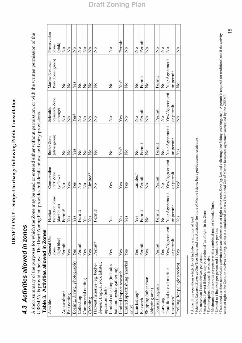
4.3
Act
iviti
es a
llow
ed in
zon
es
A s
hort
sum
mar
y of
the
purp
oses
for
whi
ch th
e Z
one
may
be
used
or
ente
red
eit
her
wit
hout
per
mis
sion
, or
wit
h th
e w
ritt
en p
erm
issi
on o
f the
G
BR
MPA
, is
prov
ided
bel
ow.
The
Dra
ft Z
onin
g Pl
an p
rovi
des
full
det
ails
of u
se a
nd e
ntry
pro
visi
ons.
T
able
3.
Act
iviti
es a
llow
ed in
Zon
es
Act
ivit
ies
Gen
eral
Use
Z
one
(l
ight
blu
e)
Hab
itat
Pr
otec
tion
Zon
e (d
ark
blue
)
Con
serv
atio
n Pa
rk Z
one
(yel
low
)
Buf
fer
Zon
e (o
live
gree
n)
Scie
ntif
ic
Res
earc
h Z
one
(ora
nge)
Mar
ine
Nat
iona
l Pa
rk Z
one
(gre
en)
Pres
erva
tion
Z
one
(p
ink)
A
quac
ultu
re
Perm
it
Perm
it1
No
No
No
No
No
Bai
t net
ting
Y
es
Yes
Y
es
No
No
No
No
Boa
ting
, div
ing,
pho
togr
aphy
Y
es
Yes
Y
es
Yes
Y
es2
Yes
N
o C
olle
ctin
g Pe
rmit
Pe
rmit
N
o N
o N
o N
o N
o C
omm
erci
al n
etti
ng
Yes
Y
es
No
No
No
No
No
Cra
bbin
g Y
es
Yes
L
imit
ed3
No
No
No
No
Har
vest
fish
erie
s (e
g. b
êche
-d
e-m
er, t
ropi
cal r
ock
lobs
ter,
aq
uari
um fi
sh)
Perm
it4
Perm
it4
No
No
No
No
No
Lim
ited
col
lect
ing
(inc
lud
es
bait
and
oys
ter
gath
erin
g)
Yes
Y
es
Yes
N
o N
o N
o N
o
Lim
ited
impa
ct r
esea
rch
Yes
Y
es
Yes
Y
es5
Yes
Y
es5
Perm
it
Lim
ited
spe
arfi
shin
g (s
nork
el
only
) Y
es
Yes
Y
es
No
No
No
No
Lin
e fi
shin
g6
Yes
Y
es
Lim
ited
7 N
o N
o N
o N
o R
esea
rch
Perm
it
Perm
it
Perm
it
Perm
it
Perm
it
Perm
it
Perm
it
Ship
ping
(oth
er th
an
ship
ping
are
a)
Yes
N
o N
o N
o N
o N
o N
o
Tou
rist
Pro
gram
Pe
rmit
Pe
rmit
Pe
rmit
Pe
rmit
Pe
rmit
Pe
rmit
N
o T
raw
ling
Yes
N
o N
o N
o N
o N
o N
o T
rad
ition
al u
se o
f mar
ine
reso
urce
s8
Yes
/Agr
eem
ent
or p
erm
it
Yes
/Agr
eem
ent
or p
erm
it
Yes
/Agr
eem
ent
or p
erm
it
Yes
/Agr
eem
ent
or p
erm
it
Yes
/Agr
eem
ent
or p
erm
it
Yes
/Agr
eem
ent
or p
erm
it
No
Tro
lling
(for
pel
agic
spe
cies
) Y
es
Yes
Y
es7
Yes
N
o N
o N
o
1 A
quac
ultu
re o
pera
tion
s w
hich
do
not i
nclu
de
the
add
itio
n of
feed
. 2 S
cien
tifi
c R
esea
rch
Zon
es a
t One
Tre
e Is
land
and
the
Aus
tral
ian
Inst
itut
e of
Mar
ine
Scie
nce
have
pub
lic a
cces
s re
stri
ctio
ns.
3 N
o m
ore
than
4 c
atch
dev
ices
per
per
son.
4 A
ccre
dit
ed h
arve
st fi
sher
ies
may
be
cond
ucte
d ‘a
s of
rig
ht’ i
n th
e Z
one.
5 P
erm
it r
equi
red
if r
esea
rch
is e
xtra
ctiv
e.
6 Max
imum
of 3
line
s/ro
ds p
er p
erso
n w
ith
a co
mbi
ned
tota
l of 6
hoo
ks/l
ures
. 7 L
imit
ed to
1 li
ne/r
od p
er p
erso
n an
d 1
hoo
k/lu
re p
er li
ne.
8 Tra
dit
iona
l use
doe
s no
t inc
lud
e ac
tivi
ties
that
are
oth
erw
ise
as o
f rig
ht w
ithi
n ea
ch Z
one
(eg.
Lim
ited
col
lect
ing,
line
fish
ing,
cra
bbin
g, e
tc.).
A p
erm
it is
req
uire
d fo
r tr
adit
iona
l use
if th
e ac
tivi
ty
not a
s of
rig
ht in
the
Zon
e, o
r in
volv
es h
unti
ng, u
nles
s it
is c
ond
ucte
d u
nder
a T
rad
itio
nal U
se o
f Mar
ine
Res
ourc
es a
gree
men
t acc
red
ited
by
the
GB
RM
P.

DRAFT ONLY – Subject to change following Public Consultation
19
5 Overview of submissions and other sources of information
5.1 Comparison between previous and current zoning processes
The number of submissions received during the first phase of community participation for the RAP rezoning process is the most received in the history of the Marine Park. The graph in Figure 2 illustrates the total number of submissions received for various zoning processes conducted by the GBRMPA since 1977, compared to the first formal phase of community participation for the RAP rezoning in 2002.
0
2,000
4,000
6,000
8,000
10,000
12,000
No. of submissions 29 920 391 233 626 1,009 138 233 10,190
Cap / Bunker 1977
Central 1983
Cairns 1983
Far Northern
1986
Mackay/ Cap 1988
Cairns 1992
Gumoo 1998
Far Northern
2001
RAP 2002
Figure 2: Submissions received for various GBRMPA zoning processes. (Note: except for the RAP 2002 figure, the number of submissions shown above is the total number of submissions received during both phases of community participation. The RAP 2002 figure represents only the first phase of community participation).
5.2 Community participation process The first formal phase of community participation for the RAP rezoning process occurred between 7 May 2002 and 7 August 2002.
The process was designed to elicit information from the community to assist with the preparation of the Draft Zoning Plan. The GBRMPA implemented a communication strategy to promote awareness, understanding and to share with the community the issues regarding impacts on the Marine Park, to explain the rezoning process and its benefits, and to encourage broad community involvement.
DRAFT ONLY – Subject to change following Public Consultation
20
. The GBRMPA undertook an extensive public communication program including the following:
• 200 formal meetings • Face-to-face engagement with approximately 6 000 people; • 1 500 community service announcements on regional television; • 33 000 submission brochures distributed; • 38 000 hits on the RAP web site; • 4 000 phone calls to the free-call number; • 100 newspaper articles; • 60 radio spots and 10 television spots; and • 70 newspaper advertisements.
5.3 Submission analysis There are important constraints on the way in which information presented in the 10 190 submissions received by the GBRMPA should be used and interpreted. Firstly, the submissions are not those from a representative sample population drawn from either geographical communities or communities of interest in the Marine Park. Accordingly, the information in each submission was analysed rather than simply recording the number of times a comment was submitted. Moreover, a planning process such as the RAP can generate varying levels of interest in the community, prompting a large number of responses from some quarters, but nothing from others. This can be due to a range of factors, such as a lack of understanding, interest or information about the issue, limited resources to respond or an assumption by some parties that they will not be affected by the proposed changes. Any summary of the content of such a large number of submissions such as this cannot fully convey the depth of information presented in many individual submissions. Submissions were received from individuals and organisations representing:
• sectoral interest groups; • community groups; • business community; • non-government organisations; • Indigenous organisation; • agencies from all three levels of government; and • Federal and State Members of Parliament.
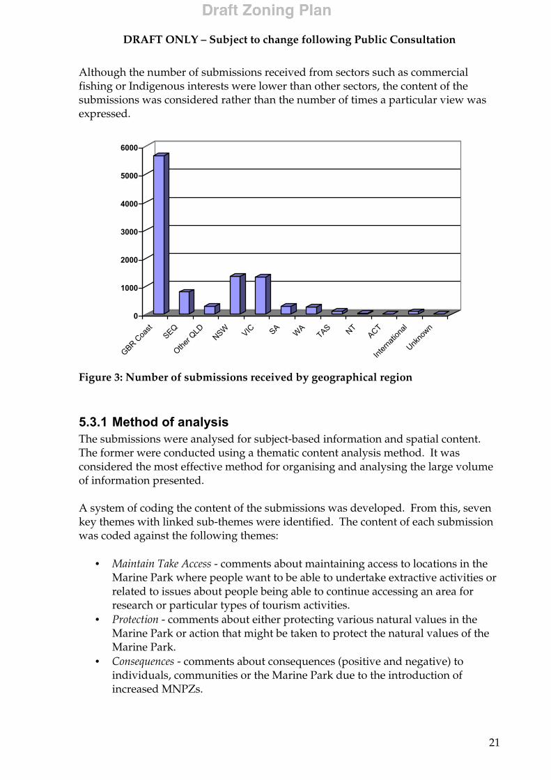
Fifty-five percent of the 10 190 submissions came from Great Barrier Reef coastal communities. Figure 3 summarises the number of submissions from each region. The majority of submissions came from individuals or groups who identified conservation or recreational fishing as their primary interests in the Marine Park.
DRAFT ONLY – Subject to change following Public Consultation
21
Although the number of submissions received from sectors such as commercial fishing or Indigenous interests were lower than other sectors, the content of the submissions was considered rather than the number of times a particular view was expressed.
0
1000
2000
3000
4000
5000
6000
GBR Coa
stSEQ
Other Q
LDNSW VIC SA
WATAS NT
ACT
Intern
ation
al
Unkno
wn
Figure 3: Number of submissions received by geographical region
5.3.1 Method of analysis The submissions were analysed for subject-based information and spatial content. The former were conducted using a thematic content analysis method. It was considered the most effective method for organising and analysing the large volume of information presented. A system of coding the content of the submissions was developed. From this, seven key themes with linked sub-themes were identified. The content of each submission was coded against the following themes:
• Maintain Take Access - comments about maintaining access to locations in the Marine Park where people want to be able to undertake extractive activities or related to issues about people being able to continue accessing an area for research or particular types of tourism activities.
• Protection - comments about either protecting various natural values in the Marine Park or action that might be taken to protect the natural values of the Marine Park.
• Consequences - comments about consequences (positive and negative) to individuals, communities or the Marine Park due to the introduction of increased MNPZs.
DRAFT ONLY – Subject to change following Public Consultation
22
• Alternatives - alternatives to MNPZs and other options that might be taken to achieve protection of biodiversity.
• Communication - comments related to communication process and information products.
• Enforcement - enforcement related issues raised in the submissions. • Other Issues - issues raised in the submissions that are not directly related to
the RAP objectives but are of relevance to Marine Park management and planning.
An Oracle database with an Access interface was specifically developed to facilitate and manage the analysis of the submissions. Procedures for handling and processing submissions, including data entry standards for maps, were also devised. The database enabled GBRMPA to answer a wide range of questions, including identification of specific issues, comments from individual sectors groups or submissions from particular geographic locations. Spatial analysis was conducted manually, by use of Geographic Information Systems, and with cross-referencing to the thematic analysis described above. Maps with information were coded for spatial references and these were used to design a Draft Zoning Plan that best reflected people’s uses and values.
5.4 Other sources of information The GBRMPA gathered a wide range of additional information and data to develop the Draft Zoning Plan. These included:
• areas used, and intensity of: • commercial trawling • commercial reef line fishing • commercial net fishing • commercial crab fishing • commercial harvest fishing • charter boat fishing
• recreational fishing (Suntag data); • recreational logbooks and diaries; • interview data on use and values; • questionnaire data on use and special/unique areas; • existing Marine Park zoning; • permits; • State closures within the Great Barrier Reef Marine Park; • State Zoning (degree of protection) of adjacent stateside land and waters; • boat ramps; • moorings and anchorages; • Native Title claims; • National Estate database; • Aboriginal and Torres Strait Islander Heritage Places database; • Historic Heritage Places database; • historic shipwrecks; • recreational/tourism use;

DRAFT ONLY – Subject to change following Public Consultation
23
• tourism settings—Cairns Area and Whitsundays Plans of Management • shell collecting areas; and • Coastwatch aerial surveillance data.
6 Issues
6.1 Conservation and biodiversity protection
6.1.1 Summary of submissions The submissions received from the conservation sector accounted for 37 percent of all submissions received, with 80 percent of these coming from coastal communities adjacent to the Marine Park.
In summary, the major issues raised by submissions from the conservation sector included:
• support for the increase in the number and size of MNPZs and that MNPZs be large and inter-connected;
• calls for MNPZs to be increased to cover greater than 25% of the Marine Park; • site specific information for consideration in the development of the Draft
Zoning Plan; • information about the need to protect a range of species (for example, dugong
and turtle habitats), natural processes, as well as protection of the World Heritage values;
• the need to protect cultural heritage values; • support for Indigenous co-management and recognition of Native Title; • concern about the level of impact from commercial fishing activities; and • other issues raised included the need for the GBRMPA to address land based
impacts and a range of other threats (for example, marine pollution and shipping impacts).
6.1.2 Responses and outcomes In conjunction with other management mechanisms, the Draft Zoning Plan aims to protect and conserve the biodiversity of the Great Barrier Reef ecosystem within a network of no-take zones. In addition to protecting ‘representative’ examples of the entire range of habitats in the Great Barrier Reef, the Draft Zoning Plan also provides for the protection of other areas of high conservation value by assigning protective zoning to other important habitats, significant breeding and spawning sites as well as special or unique sites. Details of protective zoning applied to the Marine Park are provided in Section 8 (Zone Placement, examples and basis for zoning). Details of proposed changes to zoning provisions for increased protection of biodiversity in the Marine Park are provided in Section 7.3 (Biodiversity conservation).
DRAFT ONLY – Subject to change following Public Consultation
24
6.2 Recreational fishing
6.2.1 Summary of submissions Thirty-six percent of all submissions were from people who identified themselves as being part of the recreational fishing sector. This sector accounted for the majority of submissions from communities adjacent to the Marine Park. In summary, the major issues affecting recreational fishing included:
• the need to maintain access for recreational fishing, particularly in coastal waters, from beaches, estuaries and river systems;
• fishing locations and information on fish behaviour in the local areas; • a range of alternatives to MNPZs including more Conservation Park Zones
(CPZ), increased use of bag limits and consideration that any MNPZs be located away from the coast;
• of those submissions that raised the issue of protection, many focused on making recommendations that various types of commercial fishing be banned or reduced;
• of those submissions that raised the issue of consequences to communities (due to loss of opportunity to undertake recreational fishing), most focussed on negative economic impact and negative impacts to lifestyle and family values;
• the need to address land based impacts; and • other issues raised included claims that the scientific information the GBRMPA
is using is wrong or incomplete.
6.2.2 Responses and outcomes No-take areas can protect important fish breeding and nursery areas such as seagrass beds, mangrove communities, deepwater shoals and reefs. Scientific research in the Great Barrier Reef and elsewhere shows the benefits for many species when eggs, larvae and young fish develop unhindered in protected areas. As the size of fish increase within no-take areas, bigger fish produce more offspring. Surplus adult fish, and their offspring, are not confined to the no-take areas and can move into adjoining areas, effectively creating a ‘spill-over’ effect that helps replenish fish stocks in areas where fishing is allowed. The effect of no-take areas on increasing fish stocks has been likened to a retirement savings plan, with the accumulated interest on natural capital paying valuable and sustainable dividends and hence future benefits in the long term. The GBRMPA is proposing to update/standardise use and entry provisions and definitions for recreational fishing activities in the Marine Park. Recreational fishers will benefit from the proposed changes to the Draft Zoning Plan through:
• a Zoning Plan that is standardised reef-wide, contains clearer definitions, and is easier to understand and comply with;
• greater consistency with Queensland fisheries legislation to reduce uncertainty;
• greater protection for fish species, especially those of conservation concern; • maintenance of fisheries resources for current and future generations;
DRAFT ONLY – Subject to change following Public Consultation
25
• equitable access to the CPZ for all limited extractive activities; • implementation of coordinate-based zone boundaries; • greater protection of natural resource and amenity values; and • improved enforcement of fishing provisions.
Details of protective zoning applied to areas of the Marine Park are provided in Section 8 (Zone Placement, examples and basis for zoning). Details of proposed changes to zoning provisions can be found in Section 7.1 (Recreational fishing activities).
6.3 Commercial fishing
6.3.1 Summary of submissions Submissions from the commercial fishing sector accounted for three percent of all submissions received. The majority originated from coastal communities adjacent to the Marine Park. In summary, the major issues of concern to the commercial fishing sector included:
• the need to maintain access for commercial fishing activities particularly in the coastal region;
• provision for fishing gear to be stowed and secure to ensure anchorage access in MNPZs;
• recommendations that the rezoning should align with the Queensland’s Fisheries (East Coast Trawl) Management Plan 1999 and other negotiated fisheries management agreements;
• information about areas used and comments relating to all types of fisheries in the Marine Park (including crab, line, trawl, net and dive-based fisheries);
• concern that the introduction of MNPZs would have negative economic impact and a negative impact on the income and jobs of individuals;
• comments about the contribution the commercial fishing industry makes to Queenland’s economy at a local and State level; and
• concern that increased MNPZs would result in more pressure on the system due to displaced effort from both commercial and recreational fishing.
6.3.2 Responses and outcomes World-wide there is increasing evidence that historical fisheries management practices are struggling to achieve ecological sustainable fisheries, with fishing effort increasing and fish stocks declining and in some instances collapsing. Today, with increasing effort and new technologies there are even greater pressures on fish stocks. In the Great Barrier Reef Marine Park and World Heritage Area it is essential that all fisheries are ecologically sustainable. There is an increasing awareness world-wide that the best way to ensure ecological sustainability of fisheries is to set aside areas to act as a hedge against fishery management failure and serve as reservoirs and allow for the ‘spill-over’ and recruitment effects outlined in Section 6.2.2. Therefore, the benefits of no-take areas
DRAFT ONLY – Subject to change following Public Consultation
26
for commercial fishing are substantial and the same as those outlined above for recreational fishers (Section 6.2.2). GBRMPA is proposing to update/standardise use and entry provisions and definitions for commercial fishing activities in the Marine Park. Commercial fishers will benefit from the proposed changes to the Draft Zoning Plan through:
• consistent reef-wide definitions and use and entry provisions for all commercial fishing activities;
• greater consistency with Queensland fisheries legislation; • specific provisions for most commercial harvest fisheries to enable their
conduct in relevant zones without a permit if undertaken in accordance with accredited management arrangements;
• implementation of coordinate-based zone boundaries; • greater protection of fish species, especially those of conservation concern; • maintenance of fisheries resources for current and future generations; and • clarification of requirements to stow or secure fishing gear in MNPZ.
Details of protective zoning applied to areas of the Marine Park are provided in Section 8 (Zone Placement, examples and basis for zoning). Details of proposed changes to zoning provisions can be found in Section 7.2 (Commercial fishing activities).
6.4 Tourism
6.4.1 Summary of submissions Submissions from the tourism industry accounted for just over one percent of those received. Analysis of these submissions revealed a distinction between those that supported an increase in MNPZs for non-extractive tourism and those that advocated no increase in MNPZs due to the need to maintain opportunity for tourism based on fishing. In summary, the major issues raised by submissions from the tourism sector included:
• calls for consideration of the economic impact on smaller communities if opportunities for fishing based activities are denied due to increased MNPZs;
• the need to protect species, habitats and sites of commercial tourism value such as the Ribbon Reefs;
• the need to protect the World Heritage values of the Marine Park; • calls that commercial fishing should be reduced or in some areas removed
completely; and • the need for GBRMPA to address land based impacts, anchor damage and
mooring allocation.
6.4.2 Responses and outcomes Tourism is the largest commercial activity in the Great Barrier Reef Marine Park, attracting approximately 1.8 million visitors each year (excluding ferry passengers).
DRAFT ONLY – Subject to change following Public Consultation
27
Consequently, the marine tourism industry is a major contributor to the local and Australian economies. No-take areas in the marine environment can hold the same attraction for tourists as national parks do for visitors on land. Because many no-take areas contain special and unique natural features, they often become popular for tourism and recreational activities such as snorkelling and diving (mainly at reefs or around islands). The fact that they are highly protected can become a distinct marketing advantage in attracting visitors to an area. Tourism can therefore benefit greatly from no-take areas and help bring prosperity to an area. The Draft Zoning Plan aims, in conjunction with other management mechanisms, to protect and conserve the biodiversity of the Great Barrier Reef ecosystem, while maintaining appropriate uses, such as tourism, in the Marine Park. Details of protective zoning applied to areas of the Marine Park are provided in Section 8 (Zone Placement, examples and basis for zoning). Details of proposed changes to zoning provisions can be found in Sections 7.1 (Recreational fishing activities), 7.4 (Designated Areas), 7.6 (Cruise Ship Anchorage Areas) and 7.9 (Remote Natural Area and No Structure Subzone).
6.5 Recreational usage sector submissions
6.5.1 Summary of submissions This sector represented those categories of users undertaking non-extractive recreational activities, other than those who go fishing. These included swimming and snorkelling, SCUBA diving, recreational boating and sailing and motorised water sports. These submissions accounted for approximately five percent those submissions received. Most were from people living in coastal communities adjacent to the Marine Park. In summary, the major issues raised by submissions from the non-fishing recreational use sector included:
• although this sector is classified as non-extractive recreational usage, a number of submissions presented information and views in support of maintaining access for recreational fishing;
• calls for the inclusion of spearfishing in CPZ; • the need to protect biodiversity, World Heritage values and particular
habitats; • concern about the level of commercial fishing and damage done to the Marine
Park ecosystem by certain types of commercial fishing; • support for MNPZs due to the perceived increase in fish stocks and the
benefits to tourism; • concern over possible lifestyle impacts if opportunities for recreational fishing
access was reduced; and
DRAFT ONLY – Subject to change following Public Consultation
28
• other issues raised included the need for GBRMPA to address marine pollution, coral bleaching, shipping and anchor damage.
6.5.2 Responses and outcomes The Draft Zoning Plan aims to protect and conserve the biodiversity of the Great Barrier Reef ecosystem within a network of no-take zones, while maintaining non-extractive recreational use of the Marine Park. Details of protective zoning applied to areas of the Marine Park are provided in Section 8 (Zone Placement, examples and basis for zoning). Details of proposed changes to zoning provisions can be found in Sections 7.1 (Recreational fishing activities), 7.2 (Commercial fishing activities) and 7.9 (Remote Natural Area and No Structure Subzone).
6.6 Indigenous issues
6.6.1 Summary of submissions Few submissions were received from individuals presenting Indigenous viewpoints. However, some were received from a number of Indigenous representative organisations. In summary, the major issues raised by submissions presenting Indigenous viewpoints included:
• the need to maintain opportunities for traditional hunting and fishing in addition to opportunities for recreational fishing;
• the need to protect cultural heritage values, World Heritage values and particular species and habitats within the Marine Park;
• calls for the reduction or banning of some forms of commercial fishing; • concern that the introduction of increased MNPZs will have a negative impact
on peoples’ lifestyles; • concern about the possible negative economic impacts due to loss of
opportunities for tourism based upon fishing; • issues of Native Title and co-management; and • concern about impacts from shipping, land based impacts, motorised water
sports and coral bleaching.
6.6.2 Responses and outcomes The Draft Zoning Plan expressly acknowledges the rights and interests of Indigenous Australians in the Marine Park by providing for the management of the traditional use of marine resources, including traditional hunting, in accordance with Aboriginal and Torres Strait Islander custom and tradition. Details of protective zoning applied to areas of the Marine Park are provided in Section 8 (Zone Placement, examples and basis for zoning). Details of proposed changes to zoning provisions can be found in Section 7.8 (Traditional Use of Marine Resources).
DRAFT ONLY – Subject to change following Public Consultation
29
6.7 GBR coastal community residents
6.7.1 Summary of submissions Submissions from this sector accounted for four percent of those received. Many were from local community organisations or individuals expressing concern about the potential impacts of increased MNPZs. In summary, the major issues raised by submissions from those who primarily identified as residents in coastal communities adjacent to the Marine Park included:
• the need to maintain access for recreational fishing; • the need to maintain access to beaches and waters adjacent to urban settled
areas; • protecting the reef by reducing or banning some types of commercial fishing; • a range of alternatives to MNPZs such as introducing CPZs and making better
use of fisheries regulations (including bag limits and size restrictions); • the possible lifestyle, family and economic impacts of increased MNPZs; and • other issues raised included the need for GBRMPA to address land based,
commercial shipping and tourism activity impacts.
6.7.2 Responses and outcomes The GBRMPA is proposing to update and standardise use and entry provisions and definitions for all activities in the Marine Park. Coastal communities will benefit from the proposed changes to the Draft Zoning Plan (refer to Section 6.2 (Recreational fishing activities)). Details of protective zoning applied to areas of the Marine Park are provided in Section 8 (Zone Placement, examples and basis for zoning). Details of proposed changes to zoning provisions can be found in Section 7 (Proposed management changes).
6.8 Research and monitoring
6.8.1 Summary of submissions Submissions from the research sector represented less than one percent of those received. Many originated from scientists with research interests in the Marine Park, research organisations, organisations representing scientists (for example, the Australian Coral Reef Society, Australian Marine Science Association and universities). In summary, the major issues raised by submissions from the research sector included:
• statements supporting an increase in MNPZs and for the intent of the RAP; • site specific information to support claims for the inclusion of areas in
MNPZs; • the need to maintain opportunities for extractive research to occur in SRZs
and around research stations and other areas within the Marine Park;
DRAFT ONLY – Subject to change following Public Consultation
30
• issues for the management of research and recommendations for zoning to include provision for various types of research; and
• the need for GBRMPA to address land based impacts.
6.8.2 Responses and outcomes The GBRMPA supports research in the Marine Park and recognises the important role that research has played, and continues to play, in providing a scientific basis for management and contributing to our understanding of the Marine Park. As a management agency, the GBRMPA, has chosen to obtain research primarily from external agencies, consultants and institutions. This includes all fields of study that are relevant to the Marine Park, including biological, physical, social, cultural and economic research. The Draft Zoning Plan proposes a number of measures to ensure a consistent, reef-wide approach to providing for research in the Marine Park. Details of protective zoning applied to areas of the Marine Park are provided in Section 8 (Zone Placement, examples and basis for zoning). Details of proposed changes to zoning provisions can be found in Section 7.7 (Scientific research).
6.9 Compliance, surveillance and enforcement
6.9.1 Summary of submissions A number of submissions received raised compliance, surveillance and enforcement issues, these included:
• MNPZs will not be effective if there is no enforcement; • The need to
o improve enforcement capacity; o increase fines and penalties; o increase funds for enforcement; and o seize fishing equipment as a penalty.
6.9.2 Responses and outcomes The GBRMPA acknowledges that the Draft Zoning Plan will not achieve successful outcomes for the Reef and its users without effective compliance. The Commonwealth Government has greatly strengthened the Great Barrier Reef Enforcement Program through the allocation of an additional $3.4 million dollars over the past 4 years. This means:
• patrols have been increased; • greater use of intelligence gathering and analysis has enabled strategic and
tactical planning of operations to target identified threats; and • offenders have been successfully apprehended and prosecuted.
Technology plays an increasing role in enforcement in the Marine Park. Under an arrangement with the Queensland Fisheries Service, the GBRMPA is now able to track the movements of over 500 commercial fishing boats fitted with vessel monitoring system satellite transponders to ensure compliance with zoning plans.
DRAFT ONLY – Subject to change following Public Consultation
31
High-resolution photography, night vision equipment, global positioning systems and forensic chemical analysis have been used to identify offences and provide evidence for prosecution. In 2001-02, a total of 59 commercial line fishing boats were found operating illegally in Green Zones, more than 3 times the number detected in each of the previous two years. Enforceability has been a major factor in the development of the Draft Zoning Plan:
• The Draft Zoning Plan has larger, but fewer MNPZs (Green Zones) than exist in the GBRMP under the current zoning plans.
• While the average size of the proposed MNPZs is larger, in many cases this will not greatly increase the surveillance requirement given the visual and radar capabilities of air and sea patrols.
• The proposed MNPZs are shapes more easily described by clearly defined coordinates. As well as clarifying boundaries for users, this will facilitate location and prosecution of offenders.
• The placement of many proposed zones avoid past problems such as having MNPZ reefs closely surrounded by reefs open to fishing.
The Draft Zoning Plan will be supported by a comprehensive enforcement strategy and has been designed to facilitate compliance as well as benefit GBRMP users through:
• a Zoning Plan that is standardised reef-wide, with consistent use and entry provisions and clearer definitions that are easier to understand and enforce;
• implementation of the coordinate-based zone boundaries; the new zones can be easily plotted on a chart or loaded into electronic navigation aids, this will facilitate aerial surveillance and enforcement; and
• recognising that many recreational boats may lack sophisticated navigational equipment, boundaries of inshore zones will employ landmarks or other features to clarify the location of boundaries on the water.
6.10 Commercial shipping and ports
6.10.1 Summary of submissions Submissions from the commercial shipping and ports sector represented less than one percent of submissions received. The main issues are the need to provide for ship access in the Marine Park, and harbours and jetties for small coastal communities.
6.10.2 Responses and outcomes Approximately 6000 ships transit the Marine Park each year. A major oil or chemical spill or further introductions of invasive marine pests can cause extensive, long term damage to the environmental, economic and socio-cultural values of the Marine Park. Some 600 shipping incidents have been reported since 1987 including 22 groundings and 11 collisions.
DRAFT ONLY – Subject to change following Public Consultation
32
International and national laws including the designation of the Marine Park as a Particularly Sensitive Sea Area (PSSA) in 1990 by the International Maritime Organisation (IMO), allows the Australian Government to implement a range of environmental protection measures including:
• compulsory pilotage in specified areas of the Marine Park; • the mandatory Torres Strait and Great Barrier Reef Ship Reporting System
(REEFREP) to enhance navigational safety of ships entering the reporting area; • restrictions on vessel waste discharges including oil and chemical pollution,
ballast water, garbage and litter; and • offences and penalties for damaging the reef or contravening zoning,
navigation, ship safety and other legislative provisions. Details of proposed changes to zoning provisions can be found in Section 7.5 (Shipping).
6.11 Other issues
6.11.1 Summary of submissions Many submissions from all sectors called for the GBRMPA to address land based impacts on the Marine Park. Other issues raised and not mentioned above included marine pollution, ecological impacts of commercial fishing and the need to consider Native Title and Indigenous aspirations for co-management of the Marine Park.
6.11.2 Responses and outcomes The GBRMPA has several important strategies and programs in place to manage other issues within the Marine Park. Some of the more frequent issues raised, and the ways they are being addressed, include: Water quality and coastal development The GBRMPA and Environment Australia are currently working closely with Queensland and local governments on catchment issues that affect the Great Barrier Reef. These include downstream effects of agriculture and grazing and the impacts of sediments, heavy metals and pesticides on the marine environment. Tourism and recreation industry A range of tourism management tools have been implemented cooperatively with the QPWS, including Zoning Plans, Plans of Management for high-use areas (offshore Cairns and the Whitsundays), Codes of Practice and site-specific plans. Industry best practice is encouraged through education and training programs. Protecting threatened species Specific policies and initiatives for management of threatened species, including dugong, whales, dolphins, turtles and seabirds, have been implemented or are being developed in conjunction with other agencies.
DRAFT ONLY – Subject to change following Public Consultation
33
Fishing industry The management of fisheries in the Great Barrier Reef is primarily a matter for Queensland. The GBRMPA is working with the QFS and the fishing industry to ensure fishing within the Marine Park is conducted in an ecologically sustainable manner. Following negotiations between the GBRMPA, fisheries management agencies and the fishing industry, several positive management initiatives, including Management Plans for some fisheries, have been adopted in recent years.

DRAFT ONLY – Subject to change following Public Consultation
34
7 Proposed management changes
7.1 Recreational fishing activities The GBRMPA is proposing to update/standardise use and entry provisions and definitions for recreational fishing activities in the Draft Zoning Plan. These provisions are summarised in Table 4 below. Queensland fisheries legislation also applies to all fishing activities conducted in the Marine Park. Table 4: Recreational fishing activities in Zones
ZONE
Activity
General Use Zone LIGHT BLUE
Habitat Protection Zone DARK BLUE
Conservation Park Zone YELLOW
Buffer Zone OLIVE GREEN
Scientific Research Zone ORANGE
Marine National Park Zone GREEN
Preservation Zone PINK
Line fishing (up to 3 hand-held rods/lines per person & up to 6 hooks combined total)
YES YES YES/LIMITED (1 hand-held rods/line per person & 1 hook per line)
NO NO NO NO
Trolling (no more than 2 lines per person)
YES YES YES/LIMITED (1 hand-held rods/line per person & 1 hook/lure per line)
YES – but only for pelagic species (2 lines per person)
NO NO NO
Limited spearfishing
YES YES YES NO NO NO NO
Bait netting YES YES YES NO NO NO NO Limited crabbing (4 crab pots or dillies)
YES YES YES NO NO NO NO
Limited collecting (includes oysters and bait)
YES YES YES NO NO NO NO

DRAFT ONLY – Subject to change following Public Consultation
35
7.1.1 Line fishing In the current Far Northern, Cairns and Gumoo Woojabuddee Section Zoning Plans line fishing is restricted to no more than two hand-held rods or handlines, each with only one hook, fly or lure, per person. In the Central and Mackay/Capricorn Section Zoning Plans no more than one hand-held line or handline with only one hook, fly or lure per person is allowed. Under the Draft Zoning Plan:
• Line fishing is restricted to not more than three hand-held rods or handlines with a combined number of not more than six hooks attached to the line(s) in GUZ and HPZs and not more than one hand-held rod or handline with one line and one hook per person in the CPZ.
• Trolling means fishing by the use of a line or lines trailed behind a vessel that is underway and using not more than two lines per person in GUZ, HPZ and Buffer Zone (BZ) and not more than one line per person in the CPZ. Trolling in the BZ may only be undertaken for pelagic species.
• A list of pelagic species is proposed for inclusion in the Regulations. The proposed list includes: trevallies, scad, queenfish, rainbow runner; dolphinfishes; black kingfish/cobia (single species); jobfish; barracudas (all species); billfishes, sailfishes, marlins (all species); swordfish (single species); and mackerels, tunas, bonitos, and wahoo (all species).
• To improve consistency in the use of terms, the following definitions of hook and lure are proposed to be included in the Regulations: Hook means • a single-shanked double or treble hook; or
• a lure; or • an artificial fly; or • a jig for the purposes of taking squid; or • a ganged-hook set, each component of which is in contact
with at least one of the other components in the set. Lure means an artificial bait with not more than three hooks attached to it,
in accordance with the definition proposed in the Queensland Fisheries (Coral Reef Fin Fish) Management Plan 2002 – Consultation Draft.
7.1.2 Spearfishing Under the Draft Zoning Plan:
• recreational spearfishing (limited spearfishing) means spearfishing not using a powerhead; or a firearm; or a light; or underwater breathing apparatus other than a snorkel.
DRAFT ONLY – Subject to change following Public Consultation
36
• recreational spearfishing (limited spearfishing) will be allowed in the GUZ, HPZ
and CPZs. o As recreational spearfishing is a limited extractive activity (restricted by
depth, gear and a range of other factors including the proficiency of participants), and is considered to be compatible with the zone objective, it will be allowed in the CPZ.
• Further restrictions on limited spearfishing are proposed to be included in the Regulations, including prohibiting the possession of a loaded speargun, other than in the water; or within 50 metres of another person in the water who is not a member of the spearfisher’s own group; or within 50 metres of a mooring or jetty, or within 500 metres of a resort, pontoon or aquaculture facility.
7.1.3 Limited collecting Under the Draft Zoning Plan:
• limited collecting will continue to be allowed, including the recreational collecting of shells (generally not more than 5 animals of a species are able to be taken), and the collection of bait and oysters for immediate consumption, in the GUZ and HPZs and will be allowed in the CPZ.
• it is proposed that a person can have no more than 5 individuals (unless otherwise specified) of any one species in their possession at any time. Different limits apply (for example, for bait and oysters) where specified in Queensland Fisheries Regulations 1995 and/or in the Great Barrier Reef Marine Park Regulations 1983.
7.1.4 Protected species A list of protected fish is currently included in Schedule 5 of the Regulations. The GBRMPA is proposing that this list be extended to include:
• all sizes of potato cod, hump-headed Maori wrasse and barramundi cod, consistent with zero bag limits proposed in Queensland fisheries legislation;
• all other fish species of the genus Epinephelus (cods and groupers) greater than 100cm in length (measured in accordance with Queensland fisheries legislation), consistent with maximum size limits proposed in Queensland fisheries legislation; and
• rare or threatened species including dugong, turtle, and several species of seabirds and invertebrates.
7.2 Commercial fishing activities The GBRMPA is proposing to update/standardise use and entry provisions and definitions for commercial fishing activities in the Draft Zoning Plan. These provisions are summarised in the table below. Queensland fisheries legislation continues to apply to all fishing activities conducted in the Marine Park.

DRAFT ONLY – Subject to change following Public Consultation
37
Table 5: Commercial fishing activities in Zones
General Use Zone
Habitat Protection Zone
Conservation Park Zone
Buffer Zone
Scientific Research Zone
Marine National Park Zone
Preservation Zone
ZONE Activity LIGHT
BLUE DARK BLUE
YELLOW OLIVE GREEN
ORANGE GREEN PINK
Trawling YES NO NO NO NO NO NO Commercial line fishing (maximum 3 hand-held rods/lines per person & combined total of 6 hooks)
YES YES YES/LIMITED 1 rod or handline per person & 1 hook per line, only 1 dory detached
NO NO NO NO
Commercial trolling (no more than 2 lines per person except CPZ)
YES YES YES/LIMITED 1 line per person/rod per person and one hook/lure per line
YES but only for pelagic species
NO NO NO
Commercial crabbing
YES YES YES/LIMITED 4 pots per person
NO NO NO NO
Commercial bait netting
YES YES YES/LIMITED net length not more than 250m
NO NO NO NO
Commercial netting other than bait netting
YES YES NO NO NO NO NO
Commercial harvest fishery( eg bêche-de-mer, tropical rock lobster, aquarium fish, trochus
YES if accredited PERMIT if not accredited
YES if accredited PERMIT if not accredited
NO NO NO NO NO
Commercial coral fishery (collecting)
YES if accredited PERMIT if not accredited
YES if accredited PERMIT if not accredited
NO NO NO NO NO
DRAFT ONLY – Subject to change following Public Consultation
38
7.2.1 Line fishing and trolling Refer provision changes detailed in Section 7.1.1 (Line fishing). In addition to those provisions the following is proposed:
• Regulations will require that no more than one tender commercial fishing vessel may be detached in the CPZ from a primary commercial fishing vessel.
7.2.2 Commercial dive-based fisheries Commercial dive-based fisheries include sea cucumber (bêche-de-mer), trochus, tropical spiny lobster, marine aquarium (fish and coral) fisheries undertaken in accordance with Queensland fisheries legislation. The Draft Zoning Plan will, in regards to commercial dive based fisheries:
• consolidate current zoning provisions for these fisheries (other than the coral fishery) by providing that as a harvest fishery, they may be undertaken, without a permit, in the GUZ and HPZs if management arrangements for that fishery are accredited by the GBRMPA. The current requirement of a permit for harvest fisheries in these Zones, will apply to each fishery until fishery management arrangements are accredited by the GBRMPA; and
• maintain the status quo for the commercial take of coral in the GUZ and HPZs with a permit.
7.2.3 Bait netting The GBRMPA has reviewed both the recreational and commercial limits for bait netting. Bait netting is currently unrestricted in the GUZ, HPZ and CPZs under all Zoning Plans, and includes both recreational nets (cast, scoop and seine) and commercial bait nets. The maximum allowable commercial bait net has been 400m in length in these Zones. However, it is known that this length of net is being used to capture a range of species for uses other than bait. Accordingly, it is proposed to reduce the maximum length of commercial bait net allowed in the CPZ to 250m to meet the zone objective of limited extractive use. The Draft Zoning Plan will, in regards to bait netting by the commercial sector:
• provide an updated definition of bait netting by referring to the relevant Queensland fisheries management arrangements through the Regulations.
• maintain the status quo, allowing bait netting in the GUZ, HPZ and CPZs, without a permit;
• further restrict bait netting by the commercial sector to a maximum net length of 250 metres in the CPZ; and
• remove the provision for bait netting from the Buffer Zone as this activity is no longer consistent with the objective of the Buffer Zone.
7.2.4 Commercial crabbing and commercial netting The Draft Zoning Plan will maintain the status quo for commercial crabbing and netting definitions and use and entry provisions (noting that the aquarium fish fishery is to be managed as a harvest fishery).
DRAFT ONLY – Subject to change following Public Consultation
39
7.2.5 Trawling The Draft Zoning Plan will generally maintain current management arrangements but will mirror Queensland trawl closures in the Fisheries (East Coast Trawl) Management Plan 1999 by incorporating those areas closed to trawling in the HPZ.
7.2.6 Fishing gear stowed or secured requirements Gear that is normally used for fishing must be stowed or secured in a zone in which the use of the equipment is not permitted. As discussed above in Section 7.2.1 (Line fishing and trolling), the Regulations will also require that no more than one tender commercial fishing vessel may be detached in the CPZ from a primary commercial fishing vessel. It is proposed the following definition of stowed or secured be included in the Regulations: Fishing equipment be rendered inoperative and stowed or secure in accordance with requirements declared in the GBRMP Regulations, whereby:
• trawl fishing apparatus is stowed or secured if it is rendered inoperative at least to the extent that the nets are out of the water; or the fore and aft ends are drawn up to the mast or booms; and all otter boards are drawn up to the booms or secured inboard the boat; and cod ends are open; and no part of the fishing apparatus is astern of the boat; and
• other fishing apparatus is stowed or secured if all components of the fishing apparatus are inboard the boat; or all components of the fishing apparatus are out of the water.
7.2.7 Protected species The same limits and protected species discussed in Section 7.1.4 (Protected species) apply to both commercial and recreational users of the Marine Park.
7.2.8 Aquaculture The GBRMPA recognises there is increasing interest in aquaculture along the Queensland coastline. In assessing the potential impact of aquaculture, the GBRMPA is concerned about the maintenance of natural systems and ensuring that ecological risk is minimised. Under the Draft Zoning Plan, the GBRMPA will be required to assess two basic types of aquaculture operation in the Marine Park:
• extensive aquaculture that does not include the addition of feed; and • intensive aquaculture that does include the addition of feed.
DRAFT ONLY – Subject to change following Public Consultation
40
To ensure a consistent, reef-wide approach to the management of aquaculture, the following is proposed in the Draft Zoning Plan:
• extensive aquaculture be allowed only with permission in GUZ and HPZs; • intensive aquaculture be allowed only with permission in the GUZ if the
applicant can demonstrate, to the satisfaction of the GBRMPA, that there have been operational and technological advances that substantially mitigate ecological risk;
• aquaculture not be permitted in the area encompassed by the Whitsundays Plan of Management (as provided by that Plan); and
• that aquaculture be restricted under the proposed Special Management Areas (SMAs) for Dugong Protection Area ‘A’ Zones (see Section 7.3.2 Dugong protection).
The provisions currently prescribed in the Regulations regarding the taking of leader prawn broodstock in Mission Beach Trawl Closure Area have been incorporated into the Draft Zoning Plan. It is proposed to replace the current trawl closure with an area of HPZ (the provisions only extend to the proposed HPZ and will not apply in any proposed areas of CPZ or MNPZ).
7.3 Biodiversity conservation Details of proposals in the Draft Zoning Plan to protect special or unique sites and representative areas of biodiversity are provided in this report. In addition to zone placement, a number of provisions proposed in the Draft Zoning Plan are used to provide for the conservation of biodiversity of the Marine Park.
7.3.1 Protected species The GBRMPA is proposing the same limits and protected species discussed in Sections 7.1.4 and 7.2.7 (Protected species) apply to both commercial and recreational users of the Marine Park.
7.3.2 Dugong protection Dugong Protection Areas (DPAs) are recognised as being areas of significant dugong habitat. The effective conservation of dugongs requires the protection of key habitats, including feeding and calving areas and migratory pathways. DPAs are designated under the Queensland Fisheries Regulations 1995 and have no complementary provisions under the Act. As part of the RAP process, each of the DPAs in the Marine Park was reviewed for adequacy of zoning to provide appropriate protection against specific threats to dugong. In particular, consideration was given to protection of seagrass beds. In some cases zoning a level higher than HPZ may be appropriate for the protection of dugongs. This was not generally recommended in the analysis due to commercial netting restrictions being imposed through the Queensland Fisheries Regulations 1995. However, the proposed zoning has provided for greater conservation through CPZ or MNPZs in several of the DPAs.

DRAFT ONLY – Subject to change following Public Consultation
41
To provide complementary approaches for dugong conservation, the GBRMPA intends to reflect the provisions of DPAs through designating a series of SMAs for species conservation purposes in those DPAs where the proposed zoning allows for the continuation of commercial netting. The GBRMPA will apply special management provisions to these SMAs through the Regulations. See Section 7.4.1 (Special Management Areas) for more information. Princess Charlotte Bay Princess Charlotte Bay (PCB) is currently zoned as CPZ in the Far Northern Section Zoning Plan to protect dugong. The Far Northern Section Zoning Plan intended to provide for permits to be granted for commercial netting in PCB, subject to the limitations in the GBRMP Regulations. However, the proposed Princess Charlotte Bay Regulations were disallowed by the Senate in April 2002 and accordingly there is no process in place for the granting of commercial netting permits in PCB. The Draft Zoning Plan proposes to zone a large area of PCB as MNPZ, with the remainder of PCB (including Bathurst Head) to be zoned HPZ with a SMA to restrict commercial netting. The Princess Charlotte Bay SMA will require commercial net fishers to apply for a GBRMPA permit to operate in PCB.
7.4 Designated Areas In previous Zoning Plans, designated areas have been used by the GBRMPA to manage issues or activities associated with specific areas within the Marine Park. These designated areas have included:
• Defence Areas; • Restricted Access Areas; • Replenishment Areas; • Seasonal Closure Areas; and • Special Management Areas
Due to the complex provisions associated with their designation and the implementation of other, more flexible management tools such as permits, site plans and plans of management, the GBRMPA has reviewed the way designated areas are used in the Draft Zoning Plan. The Draft Zoning Plan provides for two over-arching categories of designated areas that may be designated to address current management concerns either, by the Zoning Plan, or, after public consultation, in accordance with the Regulations:
• Special Management Areas (SMAs) are areas where specific management may provide to restrict use of or entry to a specific area of the Marine Park; and
• Shipping Areas are areas within which ships may navigate through the Marine Park.

DRAFT ONLY – Subject to change following Public Consultation
42
7.4.1 Special Management Areas SMAs restrict access or use within a specific area of the Marine Park, providing a more flexible approach to implementing appropriate management strategies at a site-specific level. Special management provisions may apply to SMAs on a temporary, seasonal or permanent basis and are as described in the Regulations. A SMA may be designated for a number of reasons including:
• conservation of a particular species or natural resource, e.g. turtle, bird nesting sites or fish spawning aggregation sites;
• restricting access due to public safety; • amenity reasons; and • response to an emergency (e.g. a ship grounding, oil spill or marine pest
outbreak). Designation of a SMA requires the GBRMPA to undertake formal consultation with the community. After designation, public notices will be placed in the Commonwealth Gazette, newspapers and on the GBRMPA website to provide information on:
• the location of each SMA; • any restrictions that have been put in place; and • the length of time the designation is expected to last.
However, in an emergency situation, which requires immediate management action, an SMA may be declared by public notice, but may only be in place for a continuous period of up to 90 days. There is currently no intention to require a public consultation phase for an emergency SMA. Transitional arrangements will provide for areas that are designated under current Zoning Plans to be declared under the new special management area provisions.
7.4.1.1 Proposed Special Management Areas Several SMAs, specified in the Draft Zoning Plan, are proposed to protect dugong and restrict the use and entry into sensitive sites in the Marine Park. Species protection As discussed in Section 7.3.2 (Dugong protection) the Draft Zoning Plan proposes to reflect the provisions of Queensland DPAs by designating a series of SMAs for species conservation. The areas proposed for designation are:
• Zone ‘A’ DPAs o Port Clinton (Reef Point–Cape Clinton); o Shoalwater Bay; o Ince Bay (Cape Palmerston–Allom Point); o Stewart Peninsula–Newry Islands–Ball Bay; o Upstart Bay; o Cleveland Bay–Magnetic Island; and o Hinchinbrook Island area.
• Zone ‘B ’ DPAs o Port of Gladstone–Rodds Bay; o Clairview Bluff–Carmilla Creek;
DRAFT ONLY – Subject to change following Public Consultation
43
o Llewellyn Bay; o Ball Bay–Sand Bay; o Repulse Bay; o Edgecumbe Bay–Bowen; o Bowling Green Bay; and o Lucinda to Allingham–Halifax Bay.
Restricted Access The Draft Zoning Plan proposes SMAs (restricted access) at the following locations to reflect their status under current Zoning Plans. These areas may not be used or entered without the permission of the GBRMPA:
• Raine Island (reef 11-243); • Maclennan Cay (reef 11-070); • Moulter Cay (reef 11-130); • Australian Institute of Marine Science (AIMS) SRZ (Cape Cleveland); and • One Tree Island SRZ (reef 23-055).
7.4.2 Shipping Areas Section 7.5 below proposes several initiatives to improve the management of shipping in the Marine Park, including the designation of Shipping Areas. Ships may transit the Marine Park through the GUZ or designated Shipping Areas (subject to any limitations prescribed in the Regulations). Ships requiring access to areas outside of designated Shipping Areas, other than in GUZs, require a permit. Permission may be obtained to access all areas of the Marine Park for special ‘one off’ activities (e.g. barges, dredging for special projects) subject to the activity being consistent with the Zone objectives. The Shipping Areas proposed in the Draft Zoning Plan reflect vessel usage patterns in the inner and outer shipping routes, existing recommended tracks and proposed new routes to allow for growth in shipping. The Shipping Areas have been placed to minimise the impact on the shipping industry whilst having regard for Australia’s international obligations. Shipping Areas that are designated in the GUZ are indicative only and do not, by way of the Draft Zoning Plan, restrict the navigation of ships in that zone. Additional Shipping Areas may subsequently be designated by the Regulations.

DRAFT ONLY – Subject to change following Public Consultation
44
7.5 Shipping and related issues In addition to designating a system of Shipping Areas to provides for the navigation of ships through the Marine Park, the Draft Zoning Plan proposes several initiatives to improve the management of shipping in the Marine Park, including:
• providing an updated definition of ‘ship’ based on the Torres Strait and Great Barrier Reef Ship Reporting System (REEFREP);
• any zone (including a zone or part of a zone in the Remote Natural Area or a Designated Area) may be used or entered without permission, after notification to the GBRMPA and subject to any directions given by the GBRMPA, to locate or secure the safety of a ship that is, or may be, endangered by stress of weather or by navigational or operational hazards;
• allowing the GBRMPA to designate Special Management Areas in an emergency to promote improved management of and rapid response to maritime incidents and vessel salvage (see Section 7.4 (Special Management Areas)); and
• providing for the construction and maintenance of navigation aids by the Commonwealth and Queensland.
Exemptions to the definition of a ship include Defence force vessels and private recreational vessels (not in charter) such as super-yachts (vessels 50 metres or greater in overall length used for private recreation activities). All vessels operating in Marine Park under commercial charter, including super-yachts, will require a GBRMPA permit. The Regulations will also include a category of ‘managed vessels or aircraft’, which due to their speed, noise, or other environmental impacts will require a permit for operation in the Marine Park. This category will include hovercraft, Wing-in-Ground effect vessels, and hydrofoils.
7.6 Cruise Ship Anchorage Areas All cruise ship operations are required to obtain a permit from the GBRMPA to operate in the Marine Park. Prior to the commencement of the Far Northern Section Zoning Plan, cruise ship access to the Marine Park, including the Far Northern Section, was controlled though a combination of permits, Regulations and Plans of Management.
The revised Far Northern Section Zoning Plan introduced Cruise Ship Anchorage Areas (CSAAs). CSAAs are areas that have been assessed by the GBRMPA as suitable locations for the regular anchoring or mooring of cruise ships. Within the Remote Natural Area (RNA) of the Far Northern Section of the Marine Park, the GBRMPA must not grant a permit for anchoring or mooring a cruise ship, except in a designated CSAA.
DRAFT ONLY – Subject to change following Public Consultation
45
CSAAs are difficult to create under the provisions of the Far Northern Section Zoning Plan and are resource intensive and often inflexible. The GBRMPA believes that cruise ship anchoring and mooring could be more effectively managed through the permitting process with supporting policy, site plans and Regulations, as appropriate. Accordingly, the designation process used in the Far Northern Section will not be applied in the Draft Zoning Plan.
7.7 Scientific research The Draft Zoning Plan provides generally for the management of research in the Marine Park. It includes a system of SRZs to facilitate research around scientific research stations and other areas of high research activity. It is anticipated that the proposals outlined in the Draft Zoning Plan will streamline and standardise the research permit process to the benefit of both researchers and the GBRMPA, and will reduce number of research activities, particularly minor or low-impact projects, that require permits.
7.7.1 Zoning for recognised areas of high research activity SRZ have historically recognised areas of particular importance for research (particularly around research stations and institutions). However, access was limited to scientists only, and other activities such as education and filming could not be undertaken in the Zone. The provisions of the SRZ have been revised the Draft Zoning Plan to address the previous problems with access to the Zone. Use and entry provisions for the SRZ will be similar to those for the MNPZ for all users of the area except for bona-fide researchers conducting research in accordance with the Regulations. They will be allowed to undertake limited impact research activities without a permit and other types of research activities with a permit in the Zone. To ensure a consistent, reef-wide approach to managing research, the Draft Zoning Plan proposes to:
• designate the waters adjacent to the research institutions in the GBRMP as SRZ;
• revise the provisions of the SRZ to ensure that such zones may be used for limited impact research (both extractive and non-extractive research) without a permit;
• ensure the provisions of SRZ for uses other than research are consistent with that of the MNPZ; and
• use the SMA provisions to restrict access around One Tree Island Research Station (OTIRS) and AIMS to provide places in the Marine Park where research can be carried out without the possibility of disturbance by other users. This will maintain the current situation where access to these locations is restricted and will provide for research to be carried out without the possibility of disturbance of experiments by other users (OTIRS) and for the ongoing protection of research infrastructure (AIMS).

DRAFT ONLY – Subject to change following Public Consultation
46
7.7.2 Zoning provisions and permits The Draft Zoning Plan provides for a new system of permitting research to be implemented in the GBRMP. Research activities that represent an insignificant risk to the GBRMP, or that are consistent with the objectives of the zone, will be considered ‘as of right’ and will not require a permit. Research permits will only be required in situations where the activity may impact on the GBRMP, or where the activity involves extractive research in a zone that generally prohibits other forms of extractive use. However, extractive research activities proposed to be conducted in highly protected zones (BZ, MNPZ and PZ) must be:
• relevant to, and a priority for, the management of the GBRMP, and/or • unable to be reasonably carried out elsewhere.
Both conditions are required to be satisfied for research in the PZ. The table below summarises the requirements for research permits in different Zones of the Marine Park. Table 6: Research permit requirements for each Zone.
ZONE
Activity ZONE
General Use Zone LIGHT BLUE
Habitat Protection Zone DARK BLUE
Conservation Park Zone YELLOW
Buffer Zone OLIVE GREEN
Scientific Research Zone ORANGE
Marine National Park Zone GREEN
Preservation Zone PINK
Limited impact research (non-extractive)
No permit required
No permit required
No permit required
No permit required
No permit required
No permit required
Permit required
Limited impact research (extractive)
No permit required
No permit required
No permit required
Permit required
No permit required
Permit required
Permit required
All Other Research
Permit required
Permit required
Permit required
Permit required
Permit required
Permit required
Permit required
The following policy changes are proposed in conjunction with the Draft Zoning Plan:
• permits may be granted to cover the range of activities undertaken by a research institution (institutional permits), or research programs led by a senior researcher (umbrella permits).
• to ensure consistency with other permitted activities in the Marine Park, permit assessment fees may be introduced for research permits in the future.
• the GBRMPA may issue permits for a research program for the period of the research to a maximum of six years. Pilot studies, the use of new research techniques, or research that may present a risk to the Marine Park may be limited to a shorter period.
DRAFT ONLY – Subject to change following Public Consultation
47
Research activities involving access to biological resources will be managed in a manner consistent with Australia’s international obligations under the Convention on Biological Diversity. The GBRMPA will continue to manage the environmental impacts of access to these resources, whilst the obligation for benefit sharing agreements will be managed by Environment Australia, on behalf of the Commonwealth Government.
7.8 Traditional use of marine resources A new system for managing traditional use of marine resources in the Marine Park, including traditional hunting and traditional fishing, is proposed in the Draft Zoning Plan. Under the proposed management arrangements, traditional use of marine resources will be managed in accordance with ‘Traditional Use of Marine Resources Agreements’ that have been developed and endorsed by Traditional Owner groups and accredited by the GBRMPA. The proposed zoning provisions provide that:
• traditional fishing and collecting can be conducted ‘as of right’ (without a permit) in all Zones which generally allow for fishing and collecting;
• traditional hunting of dugong and turtle, and traditional use in other Zones will be managed under Traditional Use of Marine Resources Agreements;
• Traditional Use of Marine Resources Agreements will be developed between the GBRMPA and the Traditional Owner groups for ‘sea country’. Guidelines for establishing the Traditional Use of Marine Resources Agreement (including the contents of such agreements) will be established in consultation with traditional owner representative bodies;
• as a transitional arrangement, the permit system will continue to apply to activities whilst Traditional Use Marine Resource Agreements are being established;
• a reef-wide framework for traditional use of marine resources will be developed, in the first instance for dugong and green turtles; and
• traditional inhabitants will maintain access to all zones for non-extractive purposes.
The proposed framework will encourage a cooperative approach to the management of the Marine Park and will benefit Traditional Owners and the GBRMPA. The goal is to achieve sustainable levels of harvesting that will benefit species conservation generally, and be consistent, transparent, and enforceable.
DRAFT ONLY – Subject to change following Public Consultation
48
7.9 Remote Natural Area and No Structures Subzone The purpose of the Remote Natural Area (RNA) is to ensure that some areas of the Marine Park remain in a natural state largely unaltered by works and facilities, and provide opportunities for quiet appreciation and enjoyment of those areas. Within the RNA, motorised water sports are prohibited. The Regulations also prevent the issuing of permits for:
• carrying out works involving the dumping of spoil, reclamation, beach protection works or harbour works (excludes any works relating to the construction and operation of navigational aids);
• anchoring or mooring a cruise ship, except in a CSAA; • establishing or operating a site-dedicated tourist program; or • constructing or operating a structure other than a vessel mooring or a
navigational aid. The No Structure Subzone (NSS), currently in use in the Cains Section Zoning Plan, is similar to the RNA in that its purpose is to ensure that some areas of the GBRMP remain free from structures and permanently moored facilities. Due to the similar objectives of the RNA and NSS, the GBRMPA is proposing to retain only the RNA in the Draft Zoning Plan. The provisions of the RNA will be revised to allow the GBRMPA to consider granting permission for anchoring or mooring a cruise ship and site-dedicated tourism, subject to the normal permit assessment process. The NSS provisions will continue to be applied in the Cairns Section through the Regulations to enable the objectives of the NSS to continue to be achieved in particular locations. The GBRMPA also intends to review its policies on works, structures, motorised watersports, cruise ships and site-dedicate tourism following the rezoning process.
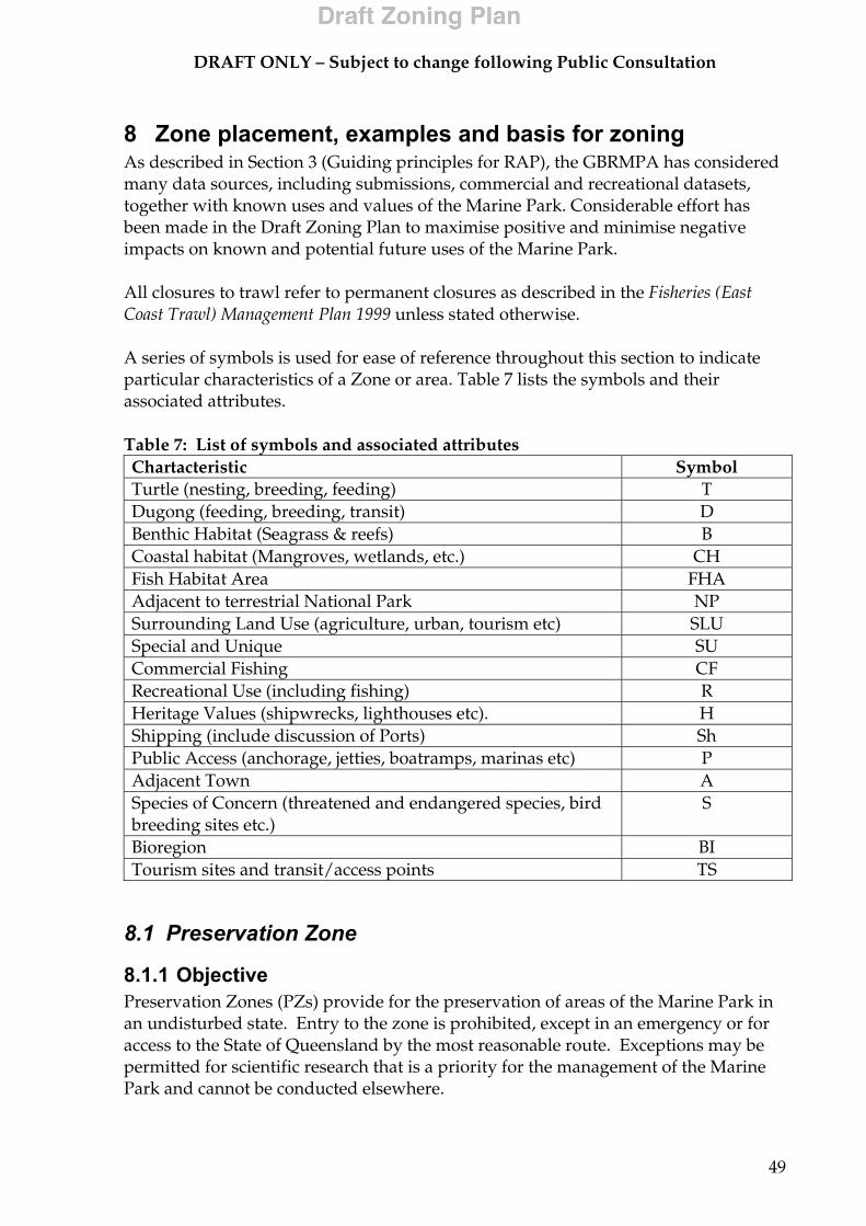
DRAFT ONLY – Subject to change following Public Consultation
49
8 Zone placement, examples and basis for zoning As described in Section 3 (Guiding principles for RAP), the GBRMPA has considered many data sources, including submissions, commercial and recreational datasets, together with known uses and values of the Marine Park. Considerable effort has been made in the Draft Zoning Plan to maximise positive and minimise negative impacts on known and potential future uses of the Marine Park. All closures to trawl refer to permanent closures as described in the Fisheries (East Coast Trawl) Management Plan 1999 unless stated otherwise. A series of symbols is used for ease of reference throughout this section to indicate particular characteristics of a Zone or area. Table 7 lists the symbols and their associated attributes. Table 7: List of symbols and associated attributes Chartacteristic Symbol Turtle (nesting, breeding, feeding) T Dugong (feeding, breeding, transit) D Benthic Habitat (Seagrass & reefs) B Coastal habitat (Mangroves, wetlands, etc.) CH Fish Habitat Area FHA Adjacent to terrestrial National Park NP Surrounding Land Use (agriculture, urban, tourism etc) SLU Special and Unique SU Commercial Fishing CF Recreational Use (including fishing) R Heritage Values (shipwrecks, lighthouses etc). H Shipping (include discussion of Ports) Sh Public Access (anchorage, jetties, boatramps, marinas etc) P Adjacent Town A Species of Concern (threatened and endangered species, bird breeding sites etc.)
S
Bioregion BI Tourism sites and transit/access points TS
8.1 Preservation Zone
8.1.1 Objective Preservation Zones (PZs) provide for the preservation of areas of the Marine Park in an undisturbed state. Entry to the zone is prohibited, except in an emergency or for access to the State of Queensland by the most reasonable route. Exceptions may be permitted for scientific research that is a priority for the management of the Marine Park and cannot be conducted elsewhere.
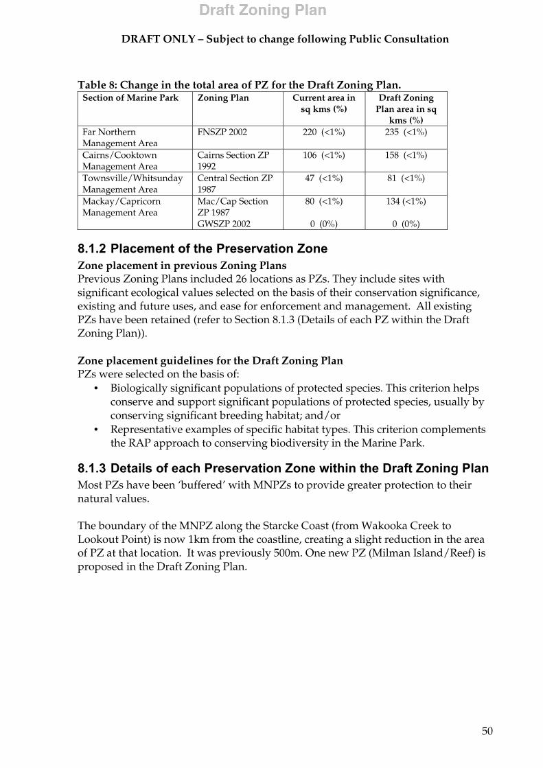
DRAFT ONLY – Subject to change following Public Consultation
50
Table 8: Change in the total area of PZ for the Draft Zoning Plan.
Section of Marine Park Zoning Plan Current area in sq kms (%)
Draft Zoning Plan area in sq
kms (%) Far Northern Management Area
FNSZP 2002 220 (<1%) 235 (<1%)
Cairns/Cooktown Management Area
Cairns Section ZP 1992
106 (<1%) 158 (<1%)
Townsville/Whitsunday Management Area
Central Section ZP 1987
47 (<1%) 81 (<1%)
Mackay/Capricorn Management Area
Mac/Cap Section ZP 1987 GWSZP 2002
80 (<1%)
0 (0%)
134 (<1%)
0 (0%)
8.1.2 Placement of the Preservation Zone Zone placement in previous Zoning Plans Previous Zoning Plans included 26 locations as PZs. They include sites with significant ecological values selected on the basis of their conservation significance, existing and future uses, and ease for enforcement and management. All existing PZs have been retained (refer to Section 8.1.3 (Details of each PZ within the Draft Zoning Plan)). Zone placement guidelines for the Draft Zoning Plan PZs were selected on the basis of:
• Biologically significant populations of protected species. This criterion helps conserve and support significant populations of protected species, usually by conserving significant breeding habitat; and/or
• Representative examples of specific habitat types. This criterion complements the RAP approach to conserving biodiversity in the Marine Park.
8.1.3 Details of each Preservation Zone within the Draft Zoning Plan Most PZs have been ‘buffered’ with MNPZs to provide greater protection to their natural values. The boundary of the MNPZ along the Starcke Coast (from Wakooka Creek to Lookout Point) is now 1km from the coastline, creating a slight reduction in the area of PZ at that location. It was previously 500m. One new PZ (Milman Island/Reef) is proposed in the Draft Zoning Plan.
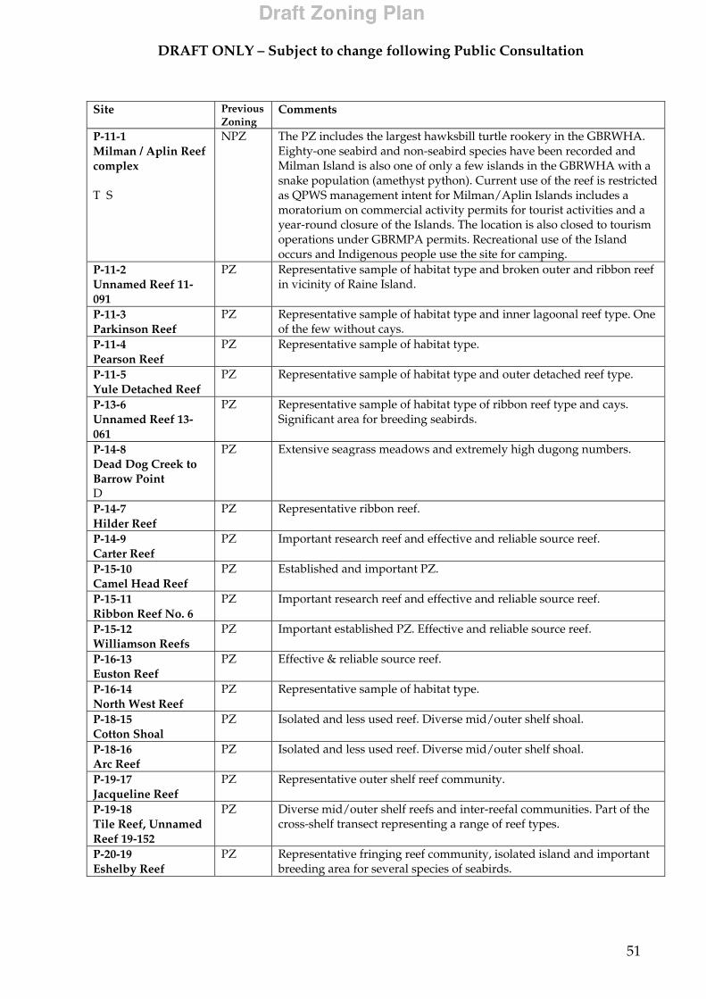
DRAFT ONLY – Subject to change following Public Consultation
51
Site Previous
Zoning Comments
P-11-1 Milman / Aplin Reef complex T S
NPZ
The PZ includes the largest hawksbill turtle rookery in the GBRWHA. Eighty-one seabird and non-seabird species have been recorded and Milman Island is also one of only a few islands in the GBRWHA with a snake population (amethyst python). Current use of the reef is restricted as QPWS management intent for Milman/Aplin Islands includes a moratorium on commercial activity permits for tourist activities and a year-round closure of the Islands. The location is also closed to tourism operations under GBRMPA permits. Recreational use of the Island occurs and Indigenous people use the site for camping.
P-11-2 Unnamed Reef 11-091
PZ Representative sample of habitat type and broken outer and ribbon reef in vicinity of Raine Island.
P-11-3 Parkinson Reef
PZ Representative sample of habitat type and inner lagoonal reef type. One of the few without cays.
P-11-4 Pearson Reef
PZ Representative sample of habitat type.
P-11-5 Yule Detached Reef
PZ Representative sample of habitat type and outer detached reef type.
P-13-6 Unnamed Reef 13-061
PZ Representative sample of habitat type of ribbon reef type and cays. Significant area for breeding seabirds.
P-14-8 Dead Dog Creek to Barrow Point D
PZ Extensive seagrass meadows and extremely high dugong numbers.
P-14-7 Hilder Reef
PZ Representative ribbon reef.
P-14-9 Carter Reef
PZ Important research reef and effective and reliable source reef.
P-15-10 Camel Head Reef
PZ Established and important PZ.
P-15-11 Ribbon Reef No. 6
PZ Important research reef and effective and reliable source reef.
P-15-12 Williamson Reefs
PZ Important established PZ. Effective and reliable source reef.
P-16-13 Euston Reef
PZ Effective & reliable source reef.
P-16-14 North West Reef
PZ Representative sample of habitat type.
P-18-15 Cotton Shoal
PZ Isolated and less used reef. Diverse mid/outer shelf shoal.
P-18-16 Arc Reef
PZ Isolated and less used reef. Diverse mid/outer shelf shoal.
P-19-17 Jacqueline Reef
PZ Representative outer shelf reef community.
P-19-18 Tile Reef, Unnamed Reef 19-152
PZ Diverse mid/outer shelf reefs and inter-reefal communities. Part of the cross-shelf transect representing a range of reef types.
P-20-19 Eshelby Reef
PZ Representative fringing reef community, isolated island and important breeding area for several species of seabirds.

DRAFT ONLY – Subject to change following Public Consultation
52
Site Previous
Zoning Comments
P-20-20 Robertson Reefs No.1
PZ Representative sample of midshelf reef
P-20-21 Olympic Reef
PZ Forms part of outer shelf 'hardline' reefs
P-21-22 Unnamed Reef 21-219
PZ Representative habitat type for outer shelf reef free from extractive activity.
P-21-23 Unnamed Reef 21-222
PZ Representative habitat type for outer shelf reef.
P-21-24 Unnamed Reef 21-507
PZ Representative sample of habitat type of lagoonal reef free from extractive activity.
P-21-25 Unnamed Reef 21-529
PZ Representative sample of habitat type of crescentic reef free from extractive activity.
P-23-26 Wreck Island Reef
PZ Representative habitat type free from extractive activity. One of the largest loggerhead turtle rookeries in the Marine Park.
P-23-27 Peak Island Reef
PZ Prime example of inshore fringing reef. Largest flatback turtle rookery in the Marine Park. Representative inshore fringing reef and associated biota.
8.2 Marine National Park Zone
8.2.1 Objectives The MNPZ allows for appreciation and enjoyment of areas in a relatively undisturbed state. The ‘look but don’t take’ zone is generally free from extractive activities. Table 9: Change in the total area of MNPZ for the Draft Zoning Plan.
Section of Marine Park Zoning Plan Marine National Park zone in sq kms (%)
Reef-wide Draft Zoning Plan in sq kms (%)
Far Northern Management Area
FNSZP 2002 11422 (13%) 30070 (35%)
Cairns/Cooktown Management Area
Cairns Section ZP 1992
630 (2%) 10108 (28%)
Townsville/Whitsundays Management Area
Central Section ZP 1987
1755 (2%) 23643 (31%)
Mackay/Capricorn Management Area
Mac/Cap Section ZP 1987 GWZP 2002
1965 (1%)
6 (1.7%)
47823 (33%)
35 (10%)
8.2.2 Placement of the Marine National Park Zone Zone Placement in previous Zoning Plans and the Draft Zoning Plan In previous Zoning Plans, MNPZs were largely placed over areas of coral reef. The GBRMPA is proposing to update this approach and to implement the RAP through the rezoning process. The Zone placement guidelines for MNPZs are described in
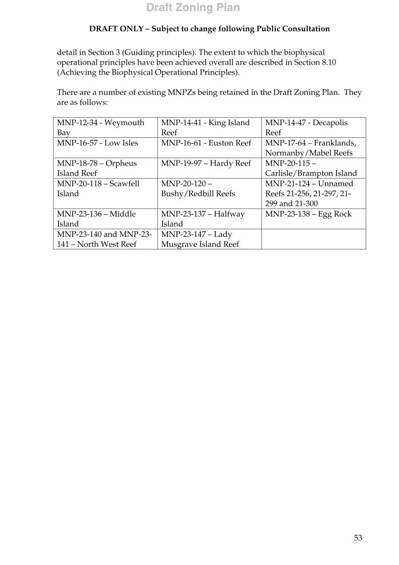
DRAFT ONLY – Subject to change following Public Consultation
53
detail in Section 3 (Guiding principles). The extent to which the biophysical operational principles have been achieved overall are described in Section 8.10 (Achieving the Biophysical Operational Principles). There are a number of existing MNPZs being retained in the Draft Zoning Plan. They are as follows: MNP-12-34 - Weymouth Bay
MNP-14-41 - King Island Reef
MNP-14-47 - Decapolis Reef
MNP-16-57 - Low Isles MNP-16-61 - Euston Reef MNP-17-64 – Franklands, Normanby/Mabel Reefs
MNP-18-78 – Orpheus Island Reef
MNP-19-97 – Hardy Reef MNP-20-115 – Carlisle/Brampton Island
MNP-20-118 – Scawfell Island
MNP-20-120 – Bushy/Redbill Reefs
MNP-21-124 – Unnamed Reefs 21-256, 21-297, 21-299 and 21-300
MNP-23-136 – Middle Island
MNP-23-137 – Halfway Island
MNP-23-138 – Egg Rock
MNP-23-140 and MNP-23-141 – North West Reef
MNP-23-147 – Lady Musgrave Island Reef
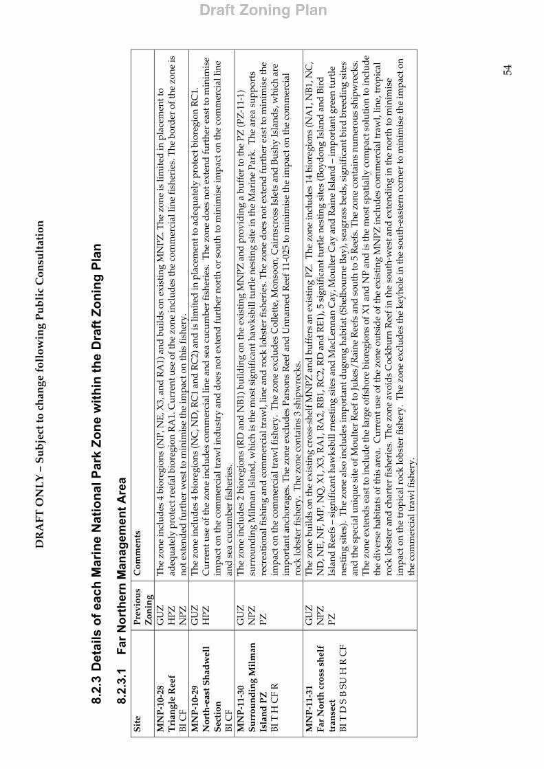
DR
AFT
ON
LY
– S
ub
ject
to c
han
ge f
ollo
win
g P
ub
lic
Con
sult
atio
n
54
8.2.
3 D
etai
ls o
f eac
h M
arin
e N
atio
nal P
ark
Zone
with
in th
e D
raft
Zoni
ng P
lan
8.2.
3.1
Far N
orth
ern
Man
agem
ent A
rea
S
ite
Pre
viou
s Z
onin
g C
omm
ents
MN
P-1
0-28
T
rian
gle
Ree
f B
I CF
GU
Z
HPZ
N
PZ
The
zone
incl
udes
4 b
iore
gion
s (N
P, N
E, X
3, a
nd R
A1)
and
bui
lds
on e
xist
ing
MN
PZ. T
he z
one
is li
mit
ed in
pla
cem
ent t
o ad
equa
tely
pro
tect
ree
fal b
iore
gion
RA
1. C
urre
nt u
se o
f the
zon
e in
clud
es th
e co
mm
erci
al li
ne fi
sher
ies.
The
bor
der
of t
he z
one
is
not e
xten
ded
furt
her
wes
t to
min
imis
e th
e im
pact
on
this
fish
ery.
M
NP
-10-
29
Nor
th-e
ast S
had
wel
l S
ecti
on
BI C
F
GU
Z
HPZ
T
he z
one
incl
udes
4 b
iore
gion
s (N
C, N
D, R
C1
and
RC
2) a
nd is
lim
ited
in p
lace
men
t to
adeq
uate
ly p
rote
ct b
iore
gion
RC
1.
Cur
rent
use
of t
he z
one
incl
udes
com
mer
cial
line
and
sea
cuc
umbe
r fi
sher
ies.
The
zon
e d
oes
not e
xten
d fu
rthe
r ea
st to
min
imis
e im
pact
on
the
com
mer
cial
traw
l ind
ustr
y an
d d
oes
not e
xten
d fu
rthe
r no
rth
or s
outh
to m
inim
ise
impa
ct o
n th
e co
mm
erci
al li
ne
and
sea
cuc
umbe
r fi
sher
ies.
M
NP
-11-
30
Su
rrou
nd
ing
Mil
man
Is
lan
d P
Z
BI T
H C
F R
GU
Z
NPZ
PZ
The
zon
e in
clud
es 2
bio
regi
ons
(RD
and
NB
1) b
uild
ing
on th
e ex
isti
ng M
NPZ
and
pro
vidi
ng a
buf
fer
to th
e PZ
(PZ
-11-
1)
surr
ound
ing
Milm
an Is
land
, whi
ch is
the
mos
t sig
nifi
cant
haw
ksbi
ll tu
rtle
nes
ting
sit
e in
the
Mar
ine
Park
. T
he a
rea
supp
orts
re
crea
tion
al fi
shin
g an
d co
mm
erci
al tr
awl,
line
and
roc
k lo
bste
r fi
sher
ies.
The
zon
e d
oes
not e
xten
d fu
rthe
r ea
st to
min
imis
e th
e im
pact
on
the
com
mer
cial
traw
l fis
hery
. T
he z
one
excl
udes
Col
lett
e, M
onso
on, C
airn
scro
ss Is
lets
and
Bus
hy Is
land
s, w
hich
are
im
port
ant a
ncho
rage
s. T
he z
one
excl
udes
Par
sons
Ree
f and
Unn
amed
Ree
f 11-
025
to m
inim
ise
the
impa
ct o
n th
e co
mm
erci
al
rock
lobs
ter
fish
ery.
The
zon
e co
ntai
ns 3
shi
pwre
cks.
M
NP
-11-
31
Far
Nor
th c
ross
sh
elf
tran
sect
B
I T D
S B
SU
H R
CF
GU
Z
NPZ
PZ
The
zon
e bu
ilds
on th
e ex
isti
ng c
ross
-she
lf M
NPZ
and
buf
fers
an
exis
ting
PZ
. T
he z
one
incl
udes
14
bior
egio
ns (N
A1,
NB1
, NC
, N
D, N
E, N
F, M
P, N
Q, X
1, X
3, R
A1,
RA
2, R
B1,
RC
2, R
D a
nd R
E1),
5 si
gnif
ican
t tur
tle
nest
ing
site
s (B
oyd
ong
Isla
nd a
nd B
ird
Is
land
Ree
fs –
sig
nifi
cant
haw
ksbi
ll rn
esti
ng s
ites
and
Mac
Len
nan
Cay
, Mou
lter
Cay
and
Rai
ne Is
land
– im
port
ant g
reen
turt
le
nest
ing
site
s).
The
zon
e al
so in
clud
es im
port
ant d
ugon
g ha
bita
t (Sh
elbo
urne
Bay
), se
agra
ss b
eds,
sig
nifi
cant
bir
d b
reed
ing
site
s an
d th
e sp
ecia
l uni
que
site
of M
oult
er R
eef t
o Ju
kes/
Rai
ne R
eefs
and
sou
th to
5 R
eefs
. The
zon
e co
ntai
ns n
umer
ous
ship
wre
cks.
T
he z
one
exte
nds
east
to in
clud
e th
e la
rge
offs
hore
bio
regi
ons
of X
1 an
d N
P an
d is
the
mos
t spa
tially
com
pact
sol
utio
n to
incl
ude
the
dive
rse
habi
tats
of t
his
area
. C
urre
nt u
se o
f the
zon
e ou
tsid
e of
the
exis
ting
MN
PZ in
clud
es c
omm
erci
al tr
awl,
line,
trop
ical
ro
ck lo
bste
r an
d c
hart
er fi
sher
ies.
The
zon
e av
oid
s C
ockb
urn
Ree
f in
the
sout
h-w
est a
nd e
xten
ding
in th
e no
rth
to m
inim
ise
impa
ct o
n th
e tr
opic
al r
ock
lobs
ter
fish
ery.
The
zon
e ex
clud
es th
e ke
yhol
e in
the
sout
h-ea
ster
n co
rner
to m
inim
ise
the
impa
ct o
n th
e co
mm
erci
al tr
awl f
ishe
ry.
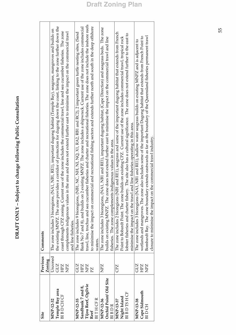
DR
AFT
ON
LY
– S
ub
ject
to c
han
ge f
ollo
win
g P
ub
lic
Con
sult
atio
n
55
S
ite
Pre
viou
s Z
onin
g C
omm
ents
MN
P-1
2-32
T
emp
le B
ay a
rea
BI B
D C
H C
F
Unz
oned
G
UZ
H
PZ
NPZ
The
zon
e in
clud
es 3
bio
regi
ons,
(NA
1, N
B1,
RE1
), im
port
ant d
ugon
g ha
bita
t (T
empl
e Ba
y), s
eagr
ass,
man
grov
es a
nd b
uild
s on
th
e ex
isti
ng M
NPZ
. The
zon
e pr
ovid
es a
cor
rid
or o
f pro
tect
ion
for
dugo
ng d
own
the
coas
t, lin
king
to th
e zo
ne fu
rthe
r do
wn
the
coas
t thr
ough
CPZ
zon
ing.
Cur
rent
use
of t
he z
one
incl
udes
the
com
mer
cial
traw
l, lin
e an
d s
ea c
ucum
ber
fish
erie
s. T
he z
one
com
plem
ents
indi
geno
us v
alue
s in
the
area
and
doe
s no
t ext
end
furt
her
east
to m
inim
ise
the
impa
ct o
n th
e co
mm
erci
al tr
awl
and
line
fish
erie
s.
MN
P-1
2-35
Sa
ndba
nk 7
and
8,
Tijo
u R
eef,
Ogi
lvie
R
eef
BI T
H C
F R
GU
Z
HPZ
N
PZ
PZ
The
zon
e in
clud
es 9
bio
regi
ons,
(NB
1, N
C, N
H, N
I, N
Q, X
1, R
A2,
RB
1 an
d R
C2)
, 2 im
port
ant g
reen
turt
le n
esti
ng s
ites
, (Sa
nd
Ban
k N
o 7
and
8),
and
build
s on
2 e
xist
ing
MN
PZ. T
he z
one
incl
udes
a s
hipw
reck
. Cur
rent
use
of t
he z
one
incl
udes
com
mer
cial
tr
awl,
line,
troc
hus
and
sea
cuc
umbe
r fi
sher
ies
and
cha
rter
and
rec
reat
iona
l fis
heri
es. T
he z
one
doe
s no
t inc
lud
e th
e in
shor
e re
efs
to m
inim
ise
the
impa
ct o
n co
mm
erci
al a
nd r
ecre
atio
nal f
ishi
ng s
ecto
rs a
nd e
xten
ds
furt
her
nort
h an
d s
outh
in th
e d
eep
offs
hore
w
ater
s.
MN
P-1
2-36
O
rch
id P
oin
t/ O
ld S
ite
BI B
D R
NPZ
T
he z
one
incl
udes
3 b
iore
gion
s, (N
A1,
NB
1 an
d R
E1),
impo
rtan
t dug
ong
habi
tat,
(Cap
e D
irec
tion
) and
sea
gras
s be
ds.
The
zon
e bu
ilds
on e
xist
ing
MN
PZ.
The
zon
e do
es n
ot e
xten
d fu
rthe
r ea
st to
min
imis
e th
e im
pact
on
the
com
mer
cial
traw
l and
line
fi
sher
ies.
The
zon
e co
mpl
emen
ts in
dige
nous
val
ues
in th
e ar
ea.
MN
P-1
3-37
N
igh
t Isl
and
B
I B D
TS
H C
F
CPZ
T
he z
one
incl
udes
2 b
iore
gion
s (N
B1 a
nd R
E1),
seag
rass
and
som
e of
the
impo
rtan
t dug
ong
habi
tat t
hat e
xten
ds fr
om F
renc
h Po
int t
o Bo
bard
t Poi
nt. T
he z
one
build
s on
exi
stin
g C
PZ.
Cur
rent
use
of t
he z
one
incl
udes
com
mer
cial
traw
l, tr
opic
al r
ock
lobs
ter
fish
erie
s an
d c
hart
er fi
sher
y. T
he s
ite
also
has
a c
ultu
ral s
igni
fica
nce.
The
zon
e d
oes
not e
xten
d fu
rthe
r to
the
east
to
min
imis
e th
e im
pact
on
the
traw
l and
line
fish
erie
s op
erat
ing
in th
is a
rea.
M
NP
-13-
38
Cap
e S
idm
outh
B
I D C
H
GU
Z
HPZ
N
PZ
The
zon
e in
clud
es 3
bio
regi
ons
(NA
1, N
B1
and
RE1
), sh
allo
w w
ater
sea
gras
s bu
ilds
on e
xist
ing
MN
PZ a
nd is
ad
jace
nt to
w
etla
nds
and
man
grov
es. T
he z
one
also
incl
udes
som
e of
the
impo
rtan
t Dug
ong
habi
tat t
hat e
xten
ds fr
om F
renc
h Po
int t
o B
omba
rdt B
ay.
The
zon
e bo
und
ary
exte
nds
east
war
ds a
s fa
r as
the
boun
dar
y of
the
Que
ensl
and
fish
erie
s pe
rman
ent t
raw
l cl
osur
e to
min
imis
e th
e im
pact
on
the
com
mer
cial
traw
l ind
ustr
y.

DR
AFT
ON
LY
– S
ub
ject
to c
han
ge f
ollo
win
g P
ub
lic
Con
sult
atio
n
56
S
ite
Pre
viou
s Z
onin
g C
omm
ents
MN
P-1
3-39
N
orth
an
d S
outh
W
ard
en R
eefs
, S
tap
leto
n I
slan
d a
nd
C
omb
e R
eef
BI D
S T
H C
F R
GU
Z
HPZ
N
PZ
PZ
The
zon
e in
clud
es 1
2 bi
oreg
ions
, (N
B1, N
J, N
L1, N
L2, N
M, N
Q, N
R, X
1, R
A2,
RD
, RF1
and
RG
1), s
hallo
w w
ater
sea
gras
s, a
nd
incl
udes
a p
ropo
rtio
n of
the
impo
rtan
t dug
ong
habi
tat t
hat e
xten
ds fr
om L
ooko
ut P
oint
to B
arro
w P
oint
. Th
e zo
ne in
clud
es
impo
rtan
t hab
itat
aro
und
bird
bre
edin
g si
tes,
(Tyd
eman
and
Dav
ies
Ree
fs) a
nd g
reen
/haw
ksbi
ll tu
rtle
fora
ging
hab
itat
. The
zo
ne a
lso
incl
udes
a s
hipw
reck
. The
zon
e bu
ilds
on th
e ex
isti
ng M
NPZ
are
as o
f nor
th a
nd s
outh
War
den
Ree
f, St
aple
ton
Isla
nd
Ree
f and
Com
be R
eef.
Cur
rent
use
in th
e zo
ne in
clud
es c
omm
erci
al tr
awl,
line,
sea
cuc
umbe
r an
d aq
uari
um fi
sher
ies
and
char
ter
and
rec
reat
iona
l fis
heri
es.
The
zon
e d
oes
not e
xten
d w
estw
ards
all
the
way
insh
ore
to m
inim
ise
the
impa
ct o
n th
e co
mm
erci
al
traw
l fis
hery
and
follo
ws
the
curr
ent M
NPZ
bou
ndar
y to
min
imis
e th
e im
pact
on
the
com
mer
cial
line
and
har
vest
fish
erie
s. T
he
zone
ext
end
s fu
rthe
r of
fsho
re to
incl
ude
adeq
uate
rep
rese
ntat
ion
of n
on-r
eef b
iore
gion
s X
1 an
d N
Q.
MN
P-1
3-40
C
orb
ett R
eef,
Gru
b
Ree
f an
d C
lack
Isl
and
B
I D S
U T
H R
CF
NPZ
BZ
T
he z
one
incl
udes
6 b
iore
gion
s, (N
B1,
NH
, NI,
NJ,
RC
2 an
d R
D) a
nd jo
ins
the
exis
ting
MN
PZ a
reas
of G
rub,
Cor
bett
and
Cla
ck
Ree
f. T
he z
one
incl
udes
impo
rtan
t dug
ong
habi
tat a
nd s
peci
al u
niqu
e si
te (G
rub
and
Cor
bett
Ree
fs) a
nd is
an
impo
rtan
t gre
en
and
haw
ksbi
ll tu
rtle
fora
ging
are
a. T
he z
one
incl
udes
a s
hipw
reck
. C
urre
nt u
se o
f the
zon
e in
clud
es: c
omm
erci
al tr
awl,
line,
sea
cu
cum
ber
fish
erie
s an
d c
hart
er a
nd r
ecre
atio
nal f
ishe
ries
. The
zon
e d
oes
not e
xten
d fu
rthe
r w
est o
r so
uth
to m
inim
ise
the
impa
ct
on th
e co
mm
erci
al tr
awl f
ishe
ry.
The
zon
e d
oes
not e
xten
d fu
rthe
r no
rth
to in
clud
e H
edge
Ree
f to
min
imis
e th
e im
pact
on
the
com
mer
cial
line
and
har
vest
fish
erie
s.
MN
P14
-42,
MN
P-1
4-44
C
ape
Mel
vill
e –
Red
P
oin
t B
I B S
U D
NP
CH
CF
R
GU
Z
NPZ
T
he z
one
build
s on
and
join
s th
e ex
isti
ng M
NPZ
to in
corp
orat
e im
port
ant d
ugon
g ha
bita
t (Lo
okou
t Poi
nt to
Bar
row
Poi
nt),
shal
low
wat
er s
eagr
ass
and
spe
cial
uni
que
site
(Sta
rcke
Riv
er R
egio
n fr
om N
inia
n B
ay to
Loo
kout
Poi
nt).
It in
clud
es 4
bio
regi
ons
(NA
1, N
M, R
E2
and
RF1
) and
is a
dja
cent
to C
ape
Mel
ville
Nat
iona
l Par
k an
d C
ape
Flat
tery
Dun
e La
kes
Wet
land
that
in
corp
orat
es m
angr
ove
com
mun
itie
s. T
he z
one
doe
s no
t ext
end
furt
her
east
war
d to
min
imis
e th
e im
pact
on
the
com
mer
cial
tr
awl f
ishe
ry. T
he z
one
build
s on
the
exis
ting
PZ
to o
ffer
a b
uffe
r of
pro
tect
ion
to th
e si
gnif
ican
t eco
logi
cal v
alue
s it
pro
tect
s.
MN
P-1
4-43
P
rin
cess
Ch
arlo
tte
Bay
B
I D S
U B
CH
CF
R
CPZ
N
PZ
The
zon
e in
clud
es 4
bio
regi
ons
(NA
1, N
B1,
NK
and
RE
1), s
hallo
w w
ater
sea
gras
s an
d a
pro
port
ion
of a
rea
of th
e sp
ecia
l uni
que
site
Pri
nces
s C
harl
otte
Bay
. The
zon
e al
so in
clud
es a
pro
port
ion
of th
e im
port
ant d
ugon
g ha
bita
t tha
t enc
ompa
sses
the
area
of
Port
Ste
war
t. T
he z
one
is a
dja
cent
to m
angr
oves
and
nat
iona
lly s
igni
fica
nt w
etla
nds.
Cur
rent
use
in a
nd a
roun
d th
e zo
ne
incl
udes
com
mer
cial
traw
l, ne
t and
cra
b fi
sher
ies
and
cha
rter
and
rec
reat
iona
l fis
heri
es.
The
zon
e is
loca
ted
offs
hore
to m
inim
ise
the
impa
ct o
n th
ese
fish
erie
s. T
he z
one
exte
nds
no fu
rthe
r th
an th
e bo
und
ary
of th
e Q
ueen
slan
d fi
sher
ies
perm
anen
t tra
wl
clos
ure
to m
inim
ise
the
impa
ct o
n th
e co
mm
erci
al tr
awl f
ishe
ry.
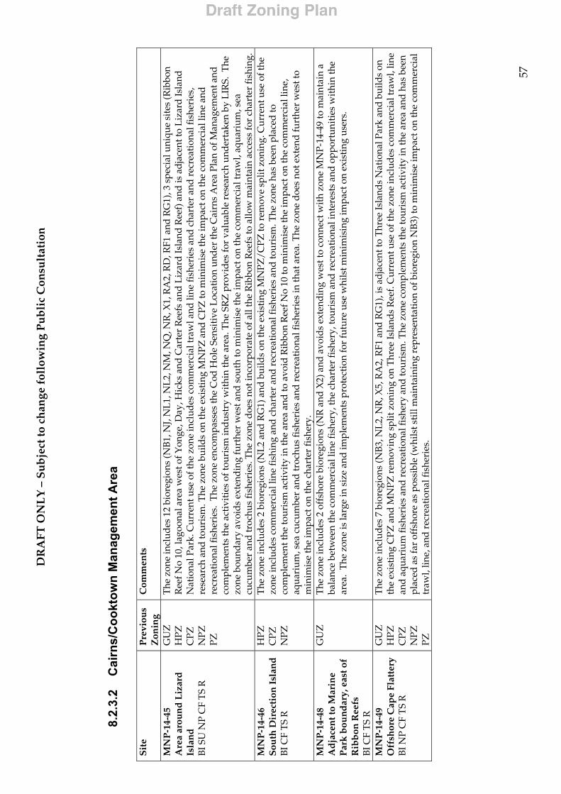
DR
AFT
ON
LY
– S
ub
ject
to c
han
ge f
ollo
win
g P
ub
lic
Con
sult
atio
n
57
8.2.
3.2
Cai
rns/
Coo
ktow
n M
anag
emen
t Are
a
S
ite
Pre
viou
s Z
onin
g C
omm
ents
MN
P-1
4-45
A
rea
arou
nd
Liz
ard
Is
lan
d
BI S
U N
P C
F T
S R
GU
Z
HPZ
C
PZ
NPZ
PZ
The
zon
e in
clud
es 1
2 bi
oreg
ions
(NB
1, N
J, N
L1, N
L2, N
M, N
Q, N
R, X
1, R
A2,
RD
, RF1
and
RG
1), 3
spe
cial
uni
que
site
s (R
ibbo
n R
eef N
o 10
, lag
oona
l are
a w
est o
f Yon
ge, D
ay, H
icks
and
Car
ter
Ree
fs a
nd L
izar
d Is
land
Ree
f) a
nd is
ad
jace
nt to
Liz
ard
Isla
nd
Nat
iona
l Par
k. C
urre
nt u
se o
f the
zon
e in
clud
es c
omm
erci
al tr
awl a
nd li
ne fi
sher
ies
and
char
ter
and
rec
reat
iona
l fis
heri
es,
rese
arch
and
tour
ism
. The
zon
e bu
ilds
on th
e ex
isti
ng M
NPZ
and
CPZ
to m
inim
ise
the
impa
ct o
n th
e co
mm
erci
al li
ne a
nd
recr
eati
onal
fish
erie
s. T
he z
one
enco
mpa
sses
the
Cod
Hol
e Se
nsit
ive
Loc
atio
n un
der
the
Cai
rns
Are
a Pl
an o
f Man
agem
ent a
nd
com
plem
ents
the
acti
viti
es o
f tou
rism
indu
stry
wit
hin
the
area
. The
SR
Z p
rovi
des
for
valu
able
res
earc
h un
dert
aken
by
LIR
S. T
he
zone
bou
ndar
y av
oid
s ex
tend
ing
furt
her
wes
t and
sou
th to
min
imis
e th
e im
pact
on
the
com
mer
cial
traw
l, aq
uari
um, s
ea
cucu
mbe
r an
d tr
ochu
s fi
sher
ies.
The
zon
e d
oes
not i
ncor
pora
te o
f all
the
Rib
bon
Ree
fs to
allo
w m
aint
ain
acce
ss fo
r ch
arte
r fi
shin
g.
MN
P-1
4-46
S
outh
Dir
ecti
on I
slan
d
BI C
F T
S R
HPZ
C
PZ
NPZ
The
zon
e in
clud
es 2
bio
regi
ons
(NL2
and
RG
1) a
nd b
uild
s on
the
exis
ting
MN
PZ/C
PZ to
rem
ove
split
zon
ing.
Cur
rent
use
of t
he
zone
incl
udes
com
mer
cial
line
fish
ing
and
cha
rter
and
rec
reat
iona
l fis
heri
es a
nd to
uris
m. T
he z
one
has
been
pla
ced
to
com
plem
ent t
he to
uris
m a
ctiv
ity
in th
e ar
ea a
nd to
avo
id R
ibbo
n R
eef N
o 10
to m
inim
ise
the
impa
ct o
n th
e co
mm
erci
al li
ne,
aqua
rium
, sea
cuc
umbe
r an
d tr
ochu
s fi
sher
ies
and
rec
reat
iona
l fis
heri
es in
that
are
a. T
he z
one
doe
s no
t ext
end
furt
her
wes
t to
min
imis
e th
e im
pact
on
the
char
ter
fish
ery.
M
NP
-14-
48
Ad
jace
nt t
o M
arin
e P
ark
bou
nd
ary,
eas
t of
Rib
bon
Ree
fs
BI C
F T
S R
GU
Z
The
zon
e in
clud
es 2
off
shor
e bi
oreg
ions
(NR
and
X2)
and
avo
ids
exte
ndin
g w
est t
o co
nnec
t wit
h zo
ne M
NP-
14-4
9 to
mai
ntai
n a
bala
nce
betw
een
the
com
mer
cial
line
fish
ery,
the
char
ter
fish
ery,
tour
ism
and
rec
reat
iona
l int
eres
ts a
nd o
ppor
tuni
ties
wit
hin
the
area
. T
he z
one
is la
rge
in s
ize
and
impl
emen
ts p
rote
ctio
n fo
r fu
ture
use
whi
lst m
inim
isin
g im
pact
on
exis
ting
use
rs.
MN
P-1
4-49
O
ffsh
ore
Cap
e Fl
atte
ry
BI N
P C
F T
S R
GU
Z
HPZ
C
PZ
NPZ
PZ
The
zon
e in
clud
es 7
bio
regi
ons
(NB3
, NL
2, N
R, X
5, R
A2,
RF1
and
RG
1), i
s ad
jace
nt to
Thr
ee Is
land
s N
atio
nal P
ark
and
build
s on
th
e ex
isti
ng C
PZ a
nd M
NPZ
rem
ovin
g sp
lit z
onin
g on
Thr
ee Is
land
s R
eef.
Cur
rent
use
of t
he z
one
incl
udes
com
mer
cial
traw
l, lin
e an
d a
quar
ium
fish
erie
s an
d r
ecre
atio
nal f
ishe
ry a
nd to
uris
m. T
he z
one
com
plem
ents
the
tour
ism
act
ivit
y in
the
area
and
has
bee
n pl
aced
as
far
offs
hore
as
poss
ible
(whi
lst s
till
mai
ntai
ning
rep
rese
ntat
ion
of b
iore
gion
NB3
) to
min
imis
e im
pact
on
the
com
mer
cial
tr
awl,
line,
and
rec
reat
iona
l fis
heri
es.
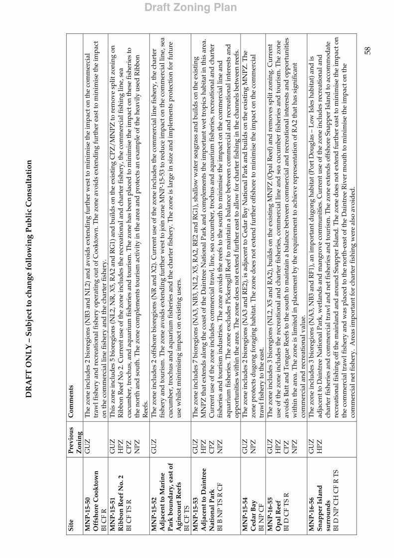
DR
AFT
ON
LY
– S
ub
ject
to c
han
ge f
ollo
win
g P
ub
lic
Con
sult
atio
n
58
S
ite
Pre
viou
s Z
onin
g C
omm
ents
MN
P-1
5-50
O
ffsh
ore
Coo
kto
wn
B
I CF
R
GU
Z
The
zon
e in
clud
es 2
bio
regi
ons
(NB3
and
NL2
) and
avo
ids
exte
ndin
g fu
rthe
r w
est t
o m
inim
ise
the
impa
ct o
n th
e co
mm
erci
al
traw
l fis
hery
and
rec
reat
iona
l fis
hery
ope
rati
ng o
ut o
f Coo
ktow
n. T
he z
one
avoi
ds
exte
ndin
g fu
rthe
r ea
st to
min
imis
e th
e im
pact
on
the
com
mer
cial
line
fish
ery
and
the
char
ter
fish
ery.
M
NP
-15-
51
Rib
bon
Ree
f N
o. 2
B
I CF
TS
R
GU
Z
HPZ
C
PZ
NPZ
Thi
s zo
ne in
clud
es 5
bio
regi
ons
(NL2
, NR
, X5,
RA
2 an
d R
G1)
and
bui
lds
on th
e ex
isti
ng C
PZ/M
NPZ
to r
emov
e sp
lit z
onin
g on
R
ibbo
n R
eef N
o 2.
Cur
rent
use
of t
he z
one
incl
udes
the
recr
eati
onal
and
cha
rter
fish
ery,
the
com
mer
cial
fish
ing
line,
sea
cu
cum
ber,
troc
hus,
and
aqu
ariu
m fi
sher
ies
and
tour
ism
. The
zon
e ha
s be
en p
lace
d to
min
imis
e th
e im
pact
on
thes
e fi
sher
ies
to
the
nort
h an
d s
outh
. The
zon
e co
mpl
emen
ts to
uris
m a
ctiv
ity
in th
e ar
ea a
nd p
rote
cts
an e
xam
ple
of th
e he
avily
use
d R
ibbo
n R
eefs
. M
NP
-15-
52
Ad
jace
nt t
o M
arin
e P
ark
bou
nd
ary,
eas
t of
Agi
nco
urt
Ree
fs
BI C
F T
S
GU
Z
The
zon
e in
clud
es 2
off
shor
e bi
oreg
ions
(NR
and
X2)
. Cur
rent
use
of t
he z
one
incl
udes
the
com
mer
cial
line
fish
ery,
the
char
ter
fish
ery
and
tour
ism
. The
zon
e av
oid
s ex
tend
ing
furt
her
wes
t to
join
zon
e M
NP-
15-5
3 to
red
uce
impa
ct o
n th
e co
mm
erci
al li
ne, s
ea
cucu
mbe
r, tr
ochu
s an
d a
quar
ium
fish
erie
s an
d th
e ch
arte
r fi
sher
y. T
he z
one
is la
rge
in s
ize
and
impl
emen
ts p
rote
ctio
n fo
r fu
ture
us
e w
hils
t min
imis
ing
impa
ct o
n ex
isti
ng u
sers
.
MN
P-1
5-53
A
dja
cen
t to
Dai
ntr
ee
Nat
ion
al P
ark
BI
B N
P T
S R
CF
GU
Z
HPZ
C
PZ
NPZ
The
zon
e in
clud
es 7
bio
regi
ons
(NA
3, N
B3,
NL2
, X5,
RA
2, R
E2 a
nd R
G1)
, sha
llow
wat
er s
eagr
ass
and
bui
lds
on th
e ex
isti
ng
MN
PZ th
at e
xten
ds a
long
the
coas
t of t
he D
aint
ree
Nat
iona
l Par
k an
d co
mpl
emen
ts th
e im
port
ant w
et tr
opic
s ha
bita
t in
this
are
a.
Cur
rent
use
of t
he z
one
incl
udes
com
mer
cial
traw
l, lin
e, s
ea c
ucum
ber,
troc
hus
and
aqua
rium
fish
erie
s, r
ecre
atio
nal a
nd c
hart
er
fish
erie
s an
d to
uris
m in
dust
ries
. The
zon
e av
oid
s th
e re
efs
to th
e so
uth
to m
inim
ise
the
impa
ct o
n th
e co
mm
erci
al li
ne a
nd
aqua
rium
fish
erie
s. T
he z
one
excl
udes
Pic
kers
gill
Ree
f to
mai
ntai
n a
bala
nce
betw
een
com
mer
cial
and
rec
reat
iona
l int
eres
ts a
nd
oppo
rtun
itie
s w
ithi
n th
e ar
ea. T
he z
one
doe
s no
t ext
end
furt
her
east
to a
llow
for
char
ter
fish
ing
in th
e ch
anne
ls b
etw
een
reef
s.
MN
P-1
5-54
C
edar
Bay
B
I NP
CF
GU
Z
NPZ
T
he z
one
incl
udes
2 b
iore
gion
s (N
A3
and
RE2
), is
ad
jace
nt to
Ced
ar B
ay N
atio
nal P
ark
and
bui
lds
on th
e ex
isti
ng M
NPZ
. The
zo
ne p
rote
cts
dug
ong
fora
ging
hab
itat.
The
zon
e d
oes
not e
xten
d fu
rthe
r of
fsho
re to
min
imis
e th
e im
pact
on
the
com
mer
cial
tr
awl f
ishe
ry to
the
east
. M
NP
-16-
55
Op
al R
eef
BI D
CF
TS R
GU
Z
HPZ
C
PZ
NPZ
The
zon
e in
clud
es 3
bio
regi
ons
(NL2
, X5
and
RA
2), b
uild
s on
the
exis
ting
MN
PZ (O
pal R
eef)
and
rem
oves
spl
it z
onin
g. C
urre
nt
use
of th
e zo
ne in
clud
es th
e re
crea
tion
al a
nd c
hart
er fi
sher
ies,
com
mer
cial
line
and
sea
cuc
umbe
r fi
sher
ies
and
tour
ism
. The
zon
e av
oids
Bat
t and
Ton
gue
Ree
fs to
the
sout
h to
mai
ntai
n a
bala
nce
betw
een
com
mer
cial
and
rec
reat
iona
l int
eres
ts a
nd o
ppor
tuni
ties
w
ithi
n th
e ar
ea. T
he z
one
is li
mit
ed in
pla
cem
ent b
y th
e re
quir
emen
t to
achi
eve
repr
esen
tati
on o
f RA
2 th
at h
as s
igni
fica
nt
com
mer
cial
and
rec
reat
iona
l val
ue.
MN
P-1
6-56
S
nap
per
Isl
and
su
rrou
nd
s B
I D N
P C
H C
F R
TS
GU
Z
HPZ
The
zon
e in
clud
es 3
bio
regi
ons
(NA
3, N
B3
and
RF1
), an
impo
rtan
t dug
ong
habi
tat (
Port
Dou
glas
– L
ow Is
les
habi
tat)
and
is
adja
cent
to D
aint
ree
Nat
iona
l Par
k, w
etla
nds
and
man
grov
e co
mm
unit
ies.
Cur
rent
use
of t
he z
one
incl
udes
rec
reat
iona
l and
ch
arte
r fi
sher
ies
and
com
mer
cial
traw
l and
net
fish
erie
s an
d to
uris
m. T
he z
one
exte
nds
offs
hore
Sna
pper
Isla
nd to
acc
omm
odat
e re
crea
tion
al fi
shin
g of
f the
mai
nlan
d an
d a
roun
d S
napp
er Is
land
. The
zon
e do
es n
ot e
xten
d fu
rthe
r ea
st to
min
imis
e th
e im
pact
on
the
com
mer
cial
traw
l fis
hery
and
was
pla
ced
to th
e no
rth-
east
of t
he D
aint
ree
Riv
er m
outh
to m
inim
ise
the
impa
ct o
n th
e co
mm
erci
al n
et fi
sher
y. A
reas
impo
rtan
t for
cha
rter
fish
ing
wer
e al
so a
void
ed.
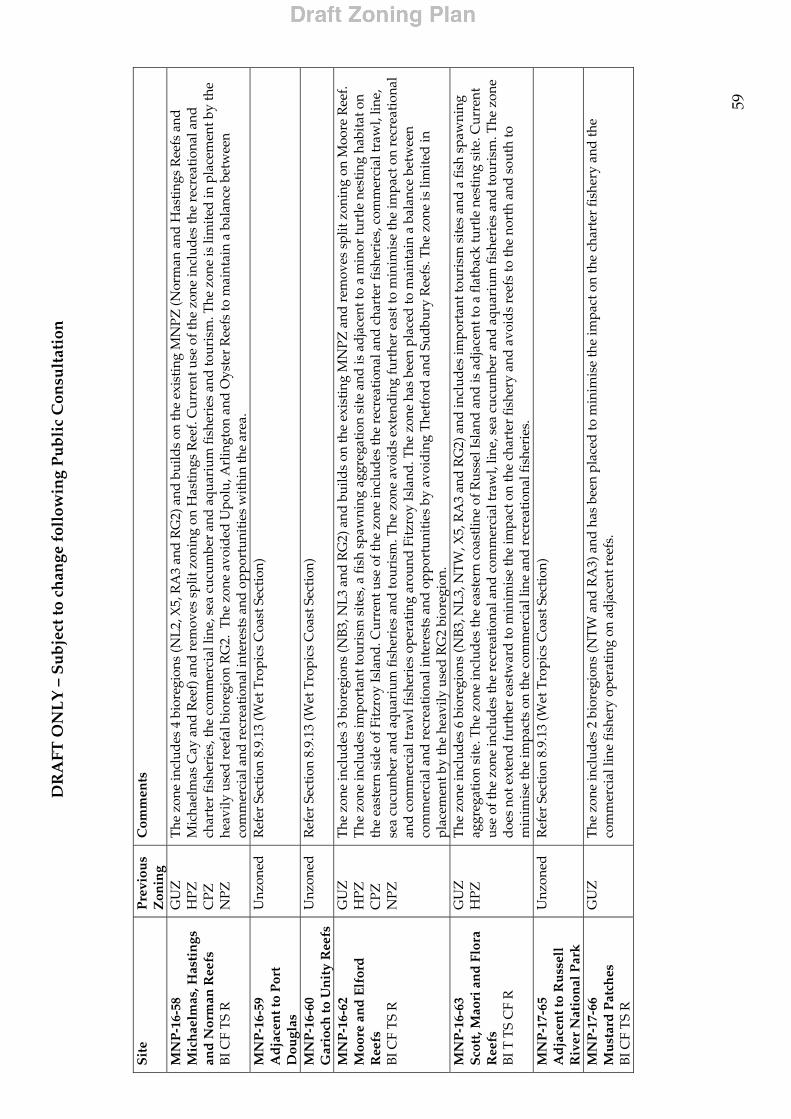
DR
AFT
ON
LY
– S
ub
ject
to c
han
ge f
ollo
win
g P
ub
lic
Con
sult
atio
n
59
S
ite
Pre
viou
s Z
onin
g C
omm
ents
MN
P-1
6-58
M
ich
aelm
as, H
asti
ngs
an
d N
orm
an R
eefs
B
I CF
TS
R
GU
Z
HPZ
C
PZ
NPZ
The
zon
e in
clud
es 4
bio
regi
ons
(NL2
, X5,
RA
3 an
d R
G2)
and
bui
lds
on th
e ex
isti
ng M
NPZ
(Nor
man
and
Has
ting
s R
eefs
and
M
icha
elm
as C
ay a
nd R
eef)
and
rem
oves
spl
it z
onin
g on
Has
ting
s R
eef.
Cur
rent
use
of t
he z
one
incl
udes
the
recr
eati
onal
and
ch
arte
r fi
sher
ies,
the
com
mer
cial
line
, sea
cuc
umbe
r an
d a
quar
ium
fish
erie
s an
d to
uris
m. T
he z
one
is li
mit
ed in
pla
cem
ent b
y th
e he
avily
use
d r
eefa
l bio
regi
on R
G2.
The
zon
e av
oide
d U
polu
, Arl
ingt
on a
nd O
yste
r R
eefs
to m
aint
ain
a ba
lanc
e be
twee
n co
mm
erci
al a
nd r
ecre
atio
nal i
nter
ests
and
opp
ortu
niti
es w
ithi
n th
e ar
ea.
MN
P-1
6-59
A
dja
cen
t to
Por
t D
ougl
as
Unz
oned
R
efer
Sec
tion
8.9
.13
(Wet
Tro
pics
Coa
st S
ecti
on)
MN
P-1
6-60
G
ario
ch to
Un
ity
Ree
fs
Unz
oned
R
efer
Sec
tion
8.9
.13
(Wet
Tro
pics
Coa
st S
ecti
on)
MN
P-1
6-62
M
oore
an
d E
lfor
d
Ree
fs
BI C
F T
S R
GU
Z
HPZ
C
PZ
NPZ
The
zon
e in
clud
es 3
bio
regi
ons
(NB3
, NL
3 an
d R
G2)
and
bui
lds
on th
e ex
isti
ng M
NPZ
and
rem
oves
spl
it z
onin
g on
Moo
re R
eef.
The
zon
e in
clud
es im
port
ant t
ouri
sm s
ites,
a fi
sh s
paw
ning
agg
rega
tion
sit
e an
d is
ad
jace
nt to
a m
inor
turt
le n
esti
ng h
abit
at o
n th
e ea
ster
n si
de
of F
itzro
y Is
land
. Cur
rent
use
of t
he z
one
incl
udes
the
recr
eati
onal
and
cha
rter
fish
erie
s, c
omm
erci
al tr
awl,
line,
se
a cu
cum
ber
and
aqua
rium
fish
erie
s an
d to
uris
m. T
he z
one
avoi
ds
exte
ndin
g fu
rthe
r ea
st to
min
imis
e th
e im
pact
on
recr
eati
onal
an
d c
omm
erci
al tr
awl f
ishe
ries
ope
ratin
g ar
ound
Fit
zroy
Isla
nd. T
he z
one
has
been
pla
ced
to m
aint
ain
a ba
lanc
e be
twee
n co
mm
erci
al a
nd r
ecre
atio
nal i
nter
ests
and
opp
ortu
niti
es b
y av
oid
ing
The
tfor
d an
d S
udbu
ry R
eefs
. The
zon
e is
lim
ited
in
plac
emen
t by
the
heav
ily u
sed
RG
2 bi
oreg
ion.
M
NP
-16-
63
Sco
tt, M
aori
an
d F
lora
R
eefs
B
I T T
S C
F R
GU
Z
HPZ
T
he z
one
incl
udes
6 b
iore
gion
s (N
B3, N
L3,
NT
W, X
5, R
A3
and
RG
2) a
nd in
clud
es im
port
ant t
ouri
sm s
ites
and
a fi
sh s
paw
ning
ag
greg
atio
n si
te. T
he z
one
incl
udes
the
east
ern
coas
tlin
e of
Rus
sel I
slan
d a
nd is
ad
jace
nt to
a fl
atba
ck tu
rtle
nes
ting
sit
e. C
urre
nt
use
of th
e zo
ne in
clud
es th
e re
crea
tion
al a
nd c
omm
erci
al tr
awl,
line,
sea
cuc
umbe
r an
d aq
uari
um fi
sher
ies
and
tour
ism
. The
zon
e d
oes
not e
xten
d fu
rthe
r ea
stw
ard
to m
inim
ise
the
impa
ct o
n th
e ch
arte
r fi
sher
y an
d av
oids
ree
fs to
the
nort
h an
d so
uth
to
min
imis
e th
e im
pact
s on
the
com
mer
cial
line
and
rec
reat
iona
l fis
heri
es.
M
NP
-17-
65
Ad
jace
nt t
o R
uss
ell
Riv
er N
atio
nal
Par
k
Unz
oned
R
efer
Sec
tion
8.9
.13
(Wet
Tro
pics
Coa
st S
ecti
on)
MN
P-1
7-66
M
ust
ard
Pat
ches
B
I CF
TS
R
GU
Z
T
he z
one
incl
udes
2 b
iore
gion
s (N
TW
and
RA
3) a
nd h
as b
een
plac
ed to
min
imis
e th
e im
pact
on
the
char
ter
fish
ery
and
the
com
mer
cial
line
fish
ery
oper
atin
g on
ad
jace
nt r
eefs
.
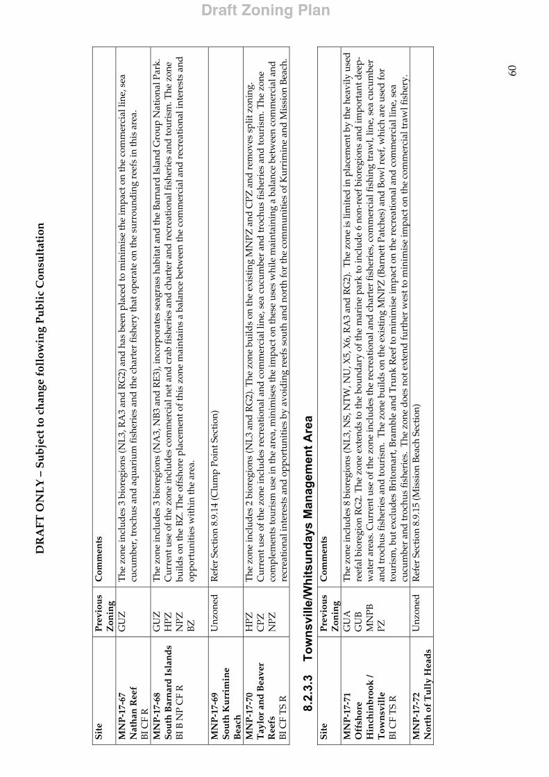
DR
AFT
ON
LY
– S
ub
ject
to c
han
ge f
ollo
win
g P
ub
lic
Con
sult
atio
n
60
S
ite
Pre
viou
s Z
onin
g C
omm
ents
MN
P-1
7-67
N
ath
an R
eef
BI C
F R
GU
Z
The
zon
e in
clud
es 3
bio
regi
ons
(NL3
, RA
3 an
d R
G2)
and
has
bee
n pl
aced
to m
inim
ise
the
impa
ct o
n th
e co
mm
erci
al li
ne, s
ea
cucu
mbe
r, tr
ochu
s an
d a
quar
ium
fish
erie
s an
d th
e ch
arte
r fi
sher
y th
at o
pera
te o
n th
e su
rrou
ndin
g re
efs
in th
is a
rea.
MN
P-1
7-68
S
outh
Bar
nar
d I
slan
ds
BI B
NP
CF
R
GU
Z
HPZ
N
PZ
BZ
The
zon
e in
clud
es 3
bio
regi
ons
(NA
3, N
B3
and
RE3
), in
corp
orat
es s
eagr
ass
habi
tat a
nd th
e Ba
rnar
d Is
land
Gro
up N
atio
nal P
ark.
C
urre
nt u
se o
f the
zon
e in
clud
es c
omm
erci
al n
et a
nd c
rab
fish
erie
s an
d c
hart
er a
nd r
ecre
atio
nal f
ishe
ries
and
tour
ism
. The
zon
e bu
ilds
on th
e B
Z. T
he o
ffsh
ore
plac
emen
t of t
his
zone
mai
ntai
ns a
bal
ance
bet
wee
n th
e co
mm
erci
al a
nd r
ecre
atio
nal i
nter
ests
and
op
port
unit
ies
wit
hin
the
area
.
M
NP
-17-
69
Sou
th K
urr
imin
e B
each
Unz
oned
R
efer
Sec
tion
8.9
.14
(Clu
mp
Poin
t Sec
tion
)
MN
P-1
7-70
Ta
ylor
and
Bea
ver
Ree
fs
BI C
F T
S R
HPZ
C
PZ
NPZ
The
zon
e in
clud
es 2
bio
regi
ons
(NL3
and
RG
2). T
he z
one
build
s on
the
exis
ting
MN
PZ a
nd C
PZ a
nd r
emov
es s
plit
zon
ing.
C
urre
nt u
se o
f the
zon
e in
clud
es r
ecre
atio
nal a
nd c
omm
erci
al li
ne, s
ea c
ucum
ber
and
troc
hus
fish
erie
s an
d to
uris
m. T
he z
one
com
plem
ents
tour
ism
use
in th
e ar
ea, m
inim
ises
the
impa
ct o
n th
ese
uses
whi
le m
aint
aini
ng a
bal
ance
bet
wee
n co
mm
erci
al a
nd
recr
eati
onal
inte
rest
s an
d o
ppor
tuni
ties
by
avoi
ding
ree
fs s
outh
and
nor
th fo
r th
e co
mm
uniti
es o
f Kur
rim
ine
and
Mis
sion
Bea
ch.
8.2.
3.3
Tow
nsvi
lle/W
hits
unda
ys M
anag
emen
t Are
a
Sit
e P
revi
ous
Zon
ing
Com
men
ts
MN
P-1
7-71
O
ffsh
ore
Hin
chin
bro
ok /
T
own
svil
le
BI C
F T
S R
GU
A
GU
B
MN
PB
PZ
The
zon
e in
clud
es 8
bio
regi
ons
(NL3
, NS,
NT
W, N
U, X
5, X
6, R
A3
and
RG
2).
The
zon
e is
lim
ited
in p
lace
men
t by
the
heav
ily u
sed
re
efal
bio
regi
on R
G2.
The
zon
e ex
tend
s to
the
boun
dary
of t
he m
arin
e pa
rk to
incl
ude
6 no
n-re
ef b
iore
gion
s an
d im
port
ant d
eep-
wat
er a
reas
. Cur
rent
use
of t
he z
one
incl
udes
the
recr
eati
onal
and
cha
rter
fish
erie
s, c
omm
erci
al fi
shin
g tr
awl,
line,
sea
cuc
umbe
r an
d tr
ochu
s fi
sher
ies
and
tour
ism
. T
he z
one
build
s on
the
exis
ting
MN
PZ (B
arne
tt P
atch
es) a
nd B
owl r
eef,
whi
ch a
re u
sed
for
tour
ism
, but
exc
lude
s Br
itom
art,
Bram
ble
and
Tru
nk R
eef t
o m
inim
ise
impa
ct o
n th
e re
crea
tion
al a
nd c
omm
erci
al li
ne, s
ea
cucu
mbe
r an
d tr
ochu
s fi
sher
ies.
The
zon
e d
oes
not e
xten
d fu
rthe
r w
est t
o m
inim
ise
impa
ct o
n th
e co
mm
erci
al tr
awl f
ishe
ry.
MN
P-1
7-72
N
orth
of
Tu
lly
Hea
ds
Unz
oned
R
efer
Sec
tion
8.9
.15
(Mis
sion
Bea
ch S
ectio
n)
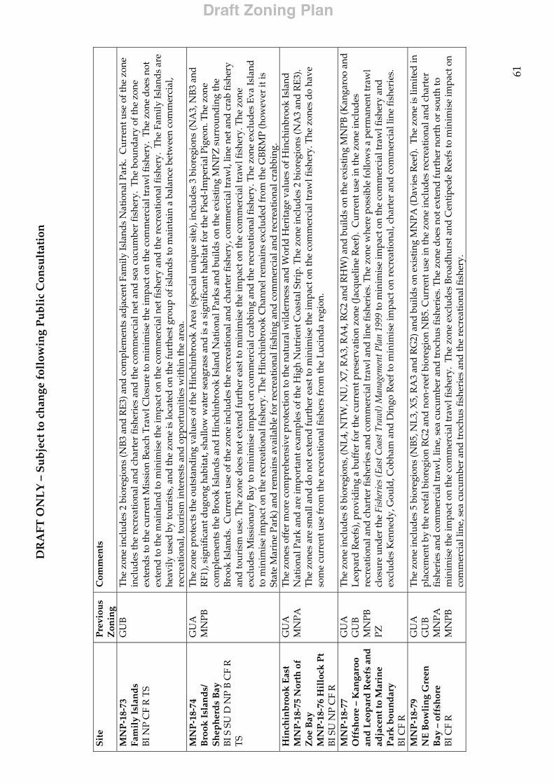
DR
AFT
ON
LY
– S
ub
ject
to c
han
ge f
ollo
win
g P
ub
lic
Con
sult
atio
n
61
S
ite
Pre
viou
s Z
onin
g C
omm
ents
MN
P-1
8-73
Fa
mil
y Is
lan
ds
BI N
P C
F R
TS
GU
B
The
zon
e in
clud
es 2
bio
regi
ons
(NB3
and
RE3
) and
com
plem
ents
ad
jace
nt F
amily
Isla
nds
Nat
iona
l Par
k. C
urre
nt u
se o
f the
zon
e in
clud
es th
e re
crea
tion
al a
nd c
hart
er fi
sher
ies
and
the
com
mer
cial
net
and
sea
cuc
umbe
r fi
sher
y. T
he b
ound
ary
of th
e zo
ne
exte
nds
to th
e cu
rren
t Mis
sion
Bea
ch T
raw
l Clo
sure
to m
inim
ise
the
impa
ct o
n th
e co
mm
erci
al tr
awl f
ishe
ry.
The
zon
e do
es n
ot
exte
nd to
the
mai
nlan
d to
min
imis
e th
e im
pact
on
the
com
mer
cial
net
fish
ery
and
the
recr
eati
onal
fish
ery.
The
Fam
ily Is
land
s ar
e he
avily
use
d b
y to
uris
ts, a
nd th
e zo
ne is
loca
ted
on
the
furt
hest
gro
up o
f isl
ands
to m
aint
ain
a ba
lanc
e be
twee
n co
mm
erci
al,
recr
eati
onal
, tou
rism
inte
rest
s an
d o
ppor
tuni
ties
wit
hin
the
area
. M
NP
-18-
74
Bro
ok I
slan
ds/
S
hep
her
ds
Bay
B
I S S
U D
NP
B C
F R
T
S
GU
A
MN
PB
The
zon
e pr
otec
ts th
e ou
tsta
ndin
g va
lues
of t
he H
inch
inbr
ook
Are
a (s
peci
al u
niqu
e si
te),
incl
udes
3 b
iore
gion
s (N
A3,
NB
3 an
d
RF1
), si
gnif
ican
t dug
ong
habi
tat,
shal
low
wat
er s
eagr
ass
and
is a
sig
nifi
cant
hab
itat
for
the
Pied
-Im
peri
al P
igeo
n. T
he z
one
com
plem
ents
the
Broo
k Is
land
s an
d H
inch
inbr
ook
Isla
nd N
atio
nal P
arks
and
bui
lds
on th
e ex
isti
ng M
NPZ
sur
roun
ding
the
Bro
ok Is
land
s. C
urre
nt u
se o
f the
zon
e in
clud
es th
e re
crea
tion
al a
nd c
hart
er fi
sher
y, c
omm
erci
al tr
awl,
line
net a
nd c
rab
fish
ery
and
tour
ism
use
. The
zon
e d
oes
not e
xten
d fu
rthe
r ea
st to
min
imis
e th
e im
pact
on
the
com
mer
cial
traw
l fis
hery
. The
zon
e ex
clud
es M
issi
onar
y B
ay to
min
imis
e im
pact
on
com
mer
cial
cra
bbin
g an
d th
e re
crea
tion
al fi
sher
y. T
he z
one
excl
udes
Eva
Isla
nd
to m
inim
ise
impa
ct o
n th
e re
crea
tion
al fi
sher
y. T
he H
inch
inbr
ook
Cha
nnel
rem
ains
exc
lud
ed fr
om th
e G
BR
MP
(how
ever
it is
St
ate
Mar
ine
Park
) and
rem
ains
ava
ilabl
e fo
r re
crea
tiona
l fis
hing
and
com
mer
cial
and
rec
reat
iona
l cra
bbin
g.
Hin
chin
bro
ok E
ast
MN
P-1
8-75
Nor
th o
f Z
oe B
ay
MN
P-1
8-76
Hil
lock
Pt
BI S
U N
P C
F R
GU
A
MN
PA
The
zon
es o
ffer
mor
e co
mpr
ehen
sive
pro
tect
ion
to th
e na
tura
l wild
erne
ss a
nd W
orld
Her
itag
e va
lues
of H
inch
inbr
ook
Isla
nd
Nat
iona
l Par
k an
d a
re im
port
ant e
xam
ples
of t
he H
igh
Nut
rien
t Coa
stal
Str
ip. T
he z
one
incl
udes
2 b
iore
gion
s (N
A3
and
RE3
). T
he z
ones
are
sm
all a
nd d
o no
t ext
end
furt
her
east
to m
inim
ise
the
impa
ct o
n th
e co
mm
erci
al tr
awl f
ishe
ry. T
he z
ones
do
have
so
me
curr
ent u
se fr
om th
e re
crea
tion
al fi
sher
s fr
om th
e L
ucin
da r
egio
n.
MN
P-1
8-77
O
ffsh
ore
– K
anga
roo
and
Leo
par
d R
eefs
an
d
adja
cen
t to
Mar
ine
Par
k b
oun
dar
y B
I CF
R
GU
A
GU
B
MN
PB
PZ
The
zon
e in
clud
es 8
bio
regi
ons,
(NL
4, N
TW
, NU
, X7,
RA
3, R
A4,
RG
2 an
d R
HW
) and
bui
lds
on th
e ex
isti
ng M
NPB
(Kan
garo
o an
d L
eopa
rd R
eefs
), pr
ovid
ing
a bu
ffer
for
the
curr
ent p
rese
rvat
ion
zone
(Jac
quel
ine
Ree
f).
Cur
rent
use
in th
e zo
ne in
clud
es
recr
eati
onal
and
cha
rter
fish
erie
s an
d c
omm
erci
al tr
awl a
nd li
ne fi
sher
ies.
The
zon
e w
here
pos
sibl
e fo
llow
s a
perm
anen
t tra
wl
clos
ure
und
er th
e Fi
sher
ies
(Eas
t Coa
st T
raw
l) M
anag
emen
t Pla
n 19
99 to
min
imis
e im
pact
on
the
com
mer
cial
traw
l fis
hery
and
ex
clud
es K
enne
dy,
Gou
ld, C
obha
m a
nd D
ingo
Ree
f to
min
imis
e im
pact
on
recr
eati
onal
, cha
rter
and
com
mer
cial
line
fish
erie
s.
MN
P-1
8-79
N
E B
owli
ng
Gre
en
Bay
– o
ffsh
ore
BI C
F R
GU
A
GU
B
MN
PA
MN
PB
The
zon
e in
clud
es 5
bio
regi
ons
(NB5
, NL
3, X
5, R
A3
and
RG
2) a
nd b
uild
s on
exi
stin
g M
NPA
(Dav
ies
Ree
f).
The
zon
e is
lim
ited
in
plac
emen
t by
the
reef
al b
iore
gion
RG
2 an
d n
on-r
eef b
iore
gion
NB5
. Cur
rent
use
in th
e zo
ne in
clud
es r
ecre
atio
nal a
nd c
hart
er
fish
erie
s an
d c
omm
erci
al tr
awl,
line,
sea
cuc
umbe
r an
d tr
ochu
s fi
sher
ies.
The
zon
e d
oes
not e
xten
d fu
rthe
r no
rth
or s
outh
to
min
imis
e th
e im
pact
on
the
com
mer
cial
traw
l fis
hery
. T
he z
one
excl
udes
Bro
adhu
rst a
nd C
entip
ede
Ree
fs to
min
imis
e im
pact
on
com
mer
cial
line
, sea
cuc
umbe
r an
d tr
ochu
s fis
heri
es a
nd th
e re
crea
tion
al fi
sher
y.
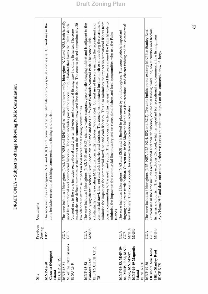
DR
AFT
ON
LY
– S
ub
ject
to c
han
ge f
ollo
win
g P
ub
lic
Con
sult
atio
n
62
S
ite
Pre
viou
s Z
onin
g C
omm
ents
MN
P-1
8-80
C
ura
coa
(Noo
goo)
Is
lan
d
BI C
F R
SU
TS
HPZ
T
he z
one
incl
udes
2 b
iore
gion
s (N
B3 a
nd R
HC
) and
form
s pa
rt o
f the
Pal
m Is
land
Gro
up s
peci
al u
niqu
e si
te.
Cur
rent
use
in th
e zo
ne in
clud
es r
ecre
atio
nal f
ishi
ng, c
omm
erci
al li
ne fi
shin
g an
d to
uris
m.
MN
P-1
8-81
S
E o
f th
e P
alm
Isl
and
s B
I SU
CF
R
GU
A
GU
B
The
zon
e in
clud
es 4
bio
regi
ons
(NA
3, N
B3,
NB5
and
RH
C) a
nd is
lim
ited
in p
lace
men
t by
bior
egio
ns N
A3
and
NB
3, b
oth
heav
ily
used
by
recr
eati
onal
and
com
mer
cial
fish
erie
s. T
he z
one
incl
udes
par
t of t
he s
peci
al u
niqu
e ha
bita
t tha
t for
ms
the
Palm
Isla
nds.
C
urre
nt u
se in
the
zone
incl
udes
rec
reat
iona
l and
cha
rter
fish
erie
s an
d c
omm
erci
al fi
shin
g tr
awl a
nd li
ne fi
sher
ies.
The
zon
e bo
und
arie
s ar
e d
efin
ed to
min
imis
e th
e im
pact
on
the
com
mer
cial
traw
l and
line
fish
erie
s. T
he z
one
is p
lace
d a
ppro
xim
atel
y 20
km
off
shor
e to
min
imis
e im
pact
on
loca
l rec
reat
iona
l fis
hing
com
mun
itie
s.
MN
P-1
8-82
P
and
ora
Ree
f B
I B T
S C
H N
P C
F R
T
S
GU
A
MN
PB
The
zon
e in
clud
es 3
bio
regi
ons
(NA
3, N
B3
and
RE3
), sh
allo
w w
ater
sea
gras
s, g
reen
turt
le fo
ragi
ng h
abit
at a
nd is
ad
jace
nt to
the
nati
onal
ly s
igni
fica
nt H
erbe
rt R
iver
Flo
odpl
ain
Wet
land
and
the
Hal
ifax
Bay
Wet
land
s N
atio
nal P
ark.
The
zon
e bu
ilds
subs
tant
ially
on
the
exis
ting
MN
PZ th
at c
urre
ntly
incl
udes
Pan
dor
a R
eef.
Cur
rent
use
of t
he z
one
incl
udes
the
recr
eati
onal
and
co
mm
erci
al tr
awl,
line,
net
and
cra
b fi
sher
ies
and
tour
ism
. T
he z
one
doe
s no
t ext
end
furt
her
nort
h or
sou
th a
long
the
coas
tlin
e to
m
inim
ise
the
impa
ct o
n th
e co
mm
erci
al tr
awl,
net a
nd c
rab
fish
erie
s. T
his
also
min
imis
es th
e im
pact
on
recr
eati
onal
fish
ers
from
co
asta
l com
mun
itie
s to
the
nort
h an
d s
outh
. T
he z
one
does
not
ext
end
furt
her
east
to a
void
the
reef
s ar
ound
the
Palm
Isla
nds
to
min
imis
e th
e im
pact
on
the
com
mer
cial
line
ind
ustr
y an
d o
n re
crea
tion
al fi
sher
s an
d lo
cal c
omm
unit
ies
who
use
the
Palm
Is
land
s.
MN
P-1
9-83
, MN
P-1
9-84
, MN
P-1
9-85
, MN
P-
19-8
6, M
NP
-19-
87,
MN
P-1
9-89
Mag
net
ic
Isla
nd
B
I NP
R C
F
GU
A
GU
B
MN
PA
MN
PB
The
zon
e in
clud
es 2
bio
regi
ons
(NA
3 an
d R
E3) a
nd is
lim
ited
in p
lace
men
t by
both
bio
regi
ons.
The
zon
e pr
otec
ts im
port
ant
dug
ong
and
gre
en tu
rtle
hab
itat
. Cur
rent
use
in th
e M
agne
tic
Isla
nd a
rea
is r
ecre
atio
nal a
nd c
hart
er fi
shin
g an
d th
e co
mm
erci
al
traw
l fis
hery
. The
zon
e is
pop
ular
for
non-
extr
acti
ve r
ecre
atio
nal a
ctiv
itie
s.
MN
P-1
9-88
O
ffsh
ore
Ayr
/Hom
e H
ill –
Sta
nle
y R
eef
BI C
F R
TS
GU
A
GU
B
MN
PB
The
zon
e in
clud
es 6
bio
regi
ons
(NB5
, NB
7, N
L3, N
L4, R
F2 a
nd R
G2)
. The
zon
e bu
ilds
on th
e ex
isti
ng M
NPB
at S
tanl
ey R
eef.
Cur
rent
use
in th
e zo
ne in
clud
es r
ecre
atio
nal a
nd c
hart
er fi
sher
ies,
com
mer
cial
fish
ing
traw
l, lin
e, s
ea c
ucum
ber
and
troc
hus
fish
erie
s an
d to
uris
m. T
he z
one
excl
udes
Old
Ree
f, w
hich
is im
port
ant f
or r
ecre
atio
nal a
nd c
omm
erci
al li
ne fi
shin
g fr
om
Ayr
/Hom
e H
ill a
nd d
oes
not e
xten
d fu
rthe
r w
est o
r ea
st to
min
imis
e im
pact
on
the
com
mer
cial
traw
l fis
hery
.
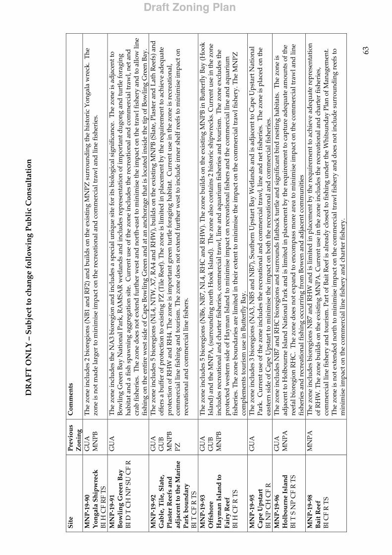
DR
AFT
ON
LY
– S
ub
ject
to c
han
ge f
ollo
win
g P
ub
lic
Con
sult
atio
n
63
S
ite
Pre
viou
s Z
onin
g C
omm
ents
MN
P-1
9-90
Y
onga
la S
hip
wre
ck
BI H
CF
RF
TS
GU
A
MN
PB
The
zon
e in
clud
es 2
bio
regi
ons
(NB1
and
RF2
) and
bui
lds
on th
e ex
isti
ng M
NPZ
sur
roun
ding
the
hist
oric
Yon
gala
wre
ck.
The
zo
ne is
not
mad
e la
rger
to m
inim
ise
impa
ct o
n th
e re
crea
tion
al a
nd c
omm
erci
al tr
awl a
nd li
ne fi
sher
ies.
MN
P-1
9-91
B
owli
ng
Gre
en B
ay
BI D
T C
H N
P SU
CF
R
GU
A
The
zon
e in
clud
es th
e N
A3
bior
egio
n an
d in
clud
es a
spe
cial
uni
que
site
for
its
biol
ogic
al s
igni
fica
nce.
The
zon
e is
ad
jace
nt to
B
owlin
g G
reen
Bay
Nat
iona
l Par
k, R
AM
SAR
wet
land
s an
d in
clud
es r
epre
sent
atio
n of
impo
rtan
t dug
ong
and
turt
le fo
ragi
ng
habi
tat a
nd a
fish
spa
wni
ng a
ggre
gati
on s
ite.
Cur
rent
use
of t
he z
one
incl
udes
the
recr
eati
onal
and
com
mer
cial
traw
l, ne
t and
cr
ab fi
sher
ies.
The
zon
e d
oes
not e
xten
d fu
rthe
r w
est a
nd n
orth
-eas
t to
min
imis
e th
e im
pact
on
the
traw
l fis
hery
and
to a
llow
line
fi
shin
g on
the
enti
re w
est s
ide
of C
ape
Bow
ling
Gre
en a
nd a
t an
anch
orag
e th
at is
loca
ted
insi
de th
e ti
p of
Bow
ling
Gre
en B
ay.
MN
P-1
9-92
G
able
, Til
e, S
late
, P
last
er R
eefs
an
d
adja
cen
t to
the
Mar
ine
Par
k b
oun
dar
y B
I T C
F R
TS
GU
A
GU
B
MN
PB
PZ
The
zon
e in
clud
es 5
bio
regi
ons
(NL4
, NT
W, X
7, R
A4
and
RH
W),
build
s on
the
exis
ting
MN
PB (S
late
, Pla
ster
and
Lat
h R
eefs
) and
of
fers
a b
uffe
r of
pro
tect
ion
to e
xist
ing
PZ (T
ile R
eef)
. The
zon
e is
lim
ited
in p
lace
men
t by
the
requ
irem
ent t
o ac
hiev
e ad
equa
te
prot
ecti
on o
f RH
W a
nd R
H4.
The
zon
e is
impo
rtan
t gre
en tu
rtle
fora
ging
hab
itat.
Cur
rent
use
in th
e zo
ne is
rec
reat
iona
l, co
mm
erci
al li
ne fi
shin
g an
d to
uris
m. T
he z
one
doe
s no
t ext
end
furt
her
wes
t to
incl
ude
inne
r sh
elf r
eefs
to m
inim
ise
impa
ct o
n re
crea
tion
al a
nd c
omm
erci
al li
ne fi
sher
s.
MN
P-1
9-93
O
ffsh
ore
Hay
man
Isl
and
to
Fair
y R
eef
BI H
CF
R T
S
GU
A
GU
B
MN
PB
The
zon
e in
clud
es 5
bio
regi
ons
(NB6
, NB
7, N
L4, R
HC
and
RH
W).
The
zon
e bu
ilds
on th
e ex
isti
ng M
NPB
in B
utte
rfly
Bay
(Hoo
k Is
land
) and
the
MN
PA, (
surr
ound
ing
nort
h H
ook
Isla
nd).
The
zon
e al
so c
onta
ins
2 hi
stor
ic s
hipw
reck
s. C
urre
nt u
se in
the
zone
in
clud
es r
ecre
atio
nal a
nd c
hart
er fi
sher
ies,
com
mer
cial
traw
l, lin
e an
d aq
uari
um fi
sher
ies
and
tour
ism
. T
he z
one
excl
udes
the
prot
ecte
d w
este
rn s
ide
of H
aym
an Is
land
to m
inim
ise
impa
ct o
n re
crea
tion
al fi
sher
s an
d th
e co
mm
erci
al li
ne a
nd a
quar
ium
fi
sher
ies.
The
zon
e bo
und
arie
s ar
e lim
ited
in th
eir
exte
nt to
min
imis
e th
e im
pact
on
the
com
mer
cial
traw
l fis
hery
. The
MN
PZ
com
plem
ents
tour
ism
use
in B
utte
rfly
Bay
. M
NP
-19-
95
Cap
e U
pst
art
BI N
P C
H C
F R
GU
A
The
zon
e in
clud
es 3
bio
regi
ons
(NA
3, N
B5
and
NB7
), So
uthe
rn U
psta
rt B
ay W
etla
nds
and
is a
dja
cent
to C
ape
Ups
tart
Nat
iona
l Pa
rk.
Cur
rent
use
of t
he z
one
incl
udes
the
recr
eati
onal
and
com
mer
cial
traw
l, lin
e an
d ne
t fis
heri
es.
The
zon
e is
pla
ced
on
the
east
ern
sid
e of
Cap
e U
psta
rt to
min
imis
e th
e im
pact
on
both
the
recr
eati
onal
and
com
mer
cial
fish
erie
s.
MN
P-1
9-96
H
olb
ourn
e Is
lan
d
BI T
S N
P C
F R
TS
GU
A
MN
PA
The
zon
e in
clud
es N
B7 a
nd R
HC
bio
regi
ons
and
sur
roun
ds
flat
back
turt
le a
nd s
igni
fica
nt b
ird
nest
ing
habi
tats
. T
he z
one
is
adja
cent
to H
olbo
urne
Isla
nd N
atio
nal P
ark
and
is li
mit
ed in
pla
cem
ent b
y th
e re
quir
emen
t to
capt
ure
adeq
uate
am
ount
s of
the
reef
al b
iore
gion
RH
C.
The
zon
e d
oes
not e
xpan
d to
enc
ompa
ss m
ore
area
to m
inim
ise
impa
ct o
n th
e co
mm
erci
al tr
awl a
nd li
ne
fish
erie
s an
d r
ecre
atio
nal f
ishi
ng o
ccur
ring
from
Bow
en a
nd a
dja
cent
com
mun
itie
s M
NP
-19-
98
Bai
t Ree
f B
I CF
R T
S
MN
PA
The
zon
e in
clud
es b
iore
gion
s N
B7 a
nd R
HW
and
is li
mit
ed in
pla
cem
ent b
y th
e re
quir
emen
t to
achi
eve
adeq
uate
rep
rese
ntat
ion
of R
HW
. The
zon
e bu
ilds
on th
e ex
isti
ng M
NPA
. Cur
rent
use
in th
e zo
ne in
clud
es th
e re
crea
tion
al a
nd c
hart
er fi
sher
ies,
co
mm
erci
al li
ne fi
sher
y an
d to
uris
m. P
art o
f Bai
t Ree
f is
alre
ady
clos
ed to
fish
ing
und
er th
e W
hits
unda
y Pl
an o
f Man
agem
ent.
T
he z
one
is n
ot e
xten
ded
nor
th to
min
imis
e im
pact
on
the
com
mer
cial
traw
l fis
hery
and
doe
s no
t inc
lude
sur
roun
ding
ree
fs to
m
inim
ise
impa
ct o
n th
e co
mm
erci
al li
ne fi
sher
y an
d c
hart
er fi
sher
y.

DR
AFT
ON
LY
– S
ub
ject
to c
han
ge f
ollo
win
g P
ub
lic
Con
sult
atio
n
64
S
ite
Pre
viou
s Z
onin
g C
omm
ents
MN
P-1
9-99
O
ffsh
ore
Rep
uls
e –
Ed
gell
, Hen
der
son
, R
ober
tson
Ree
fs
BI T
H C
F R
TS
GU
A
GU
B
MN
PB
PZ
The
zon
e in
clud
es 4
bio
regi
ons
(NB7
, NL
4, R
HW
and
RK
). T
he z
one
build
s on
the
exis
ting
MN
PB (B
ax, H
unt a
nd R
ober
tson
R
eefs
) and
off
ers
buff
er o
f pro
tect
ion
to e
xist
ing
PZ (R
ober
tson
Ree
f No.
5).
The
zon
e is
an
impo
rtan
t gre
en a
nd lo
gger
head
turt
le
fora
ging
are
a an
d in
clud
es 5
his
tori
c sh
ipw
reck
s. T
he z
one
is li
mit
ed in
pla
cem
ent b
y th
e re
quir
emen
t to
achi
eve
adeq
uate
re
pres
enta
tion
of r
eef b
iore
gion
RH
W a
nd n
on-r
eef b
iore
gion
NB
7. C
urre
nt u
se o
f the
zon
e in
clud
es th
e re
crea
tion
al fi
sher
y,
com
mer
cial
traw
l, lin
e, s
ea c
ucum
ber,
troc
hus
and
aqu
ariu
m fi
sher
ies
and
tour
ism
. The
zon
e d
oes
not e
xten
d fu
rthe
r no
rthw
est
to m
inim
ise
impa
ct o
n th
e co
mm
erci
al tr
awl f
ishe
ry a
nd e
xclu
des
ree
fs to
the
nort
h an
d s
outh
to m
inim
ise
impa
ct o
n th
e co
mm
erci
al li
ne fi
sher
y an
d r
ecre
atio
nal f
ishe
rs.
W
hit
sun
day
s R
egio
n
MN
P-2
0-10
0 –
Arm
it
Isla
nd
M
NP
-20-
101
– H
ill
Inle
t M
NP
-20-
102
– B
ord
er
Isla
nd
M
NP
-20-
103
– D
oub
le
Bay
M
NP
-20-
104
– W
hit
sun
day
Isl
and
M
NP
-20-
105
– H
asle
woo
d I
slan
d
MN
P-2
0-10
6 –
Sth
M
olle
Isl
and
M
NP
-20-
107
– S
hu
te
Isla
nd
B
I S N
P SU
CF
R B
TS
GU
A
GU
B
MN
PA
MN
PB
The
Whi
tsun
day
’s h
ave
sign
ific
ant W
orld
Her
itage
wild
erne
ss v
alue
s an
d fo
rm p
art o
f a s
peci
al u
niqu
e si
te.
The
zon
es
com
plem
ent m
ainl
and
and
isla
nd n
atio
nal s
uch
as D
ryan
der,
Whi
tsun
day
, Mol
le a
nd G
louc
este
r Is
land
Nat
iona
l Par
ks a
nd
seag
rass
bed
s in
the
area
. T
he z
ones
are
muc
h sm
alle
r in
this
reg
ion
to m
inim
ise
impa
ct o
n us
ers.
Pla
cem
ent o
f zon
es is
to
mai
ntai
n a
bala
nce
betw
een
the
com
mer
cial
, rec
reat
iona
l int
eres
ts, o
ppor
tuni
ties
and
incr
easi
ng fu
ture
use
s w
ithi
n th
is h
igh
use
area
. G
ener
ally
, the
zon
es h
ave
been
pla
ced
in m
ore
expo
sed
bay
s an
d r
eefs
to r
educ
e im
pact
on
recr
eati
onal
and
com
mer
cial
fi
sher
s an
d in
are
as w
ith
loca
l con
serv
atio
n va
lues
, enh
anci
ng a
ppre
ciat
ion
and
pro
tect
ion
of th
e ar
ea.
Loc
alis
ed v
alue
s in
clud
e bi
rd n
esti
ng s
ites
on
Arm
it Is
land
s, k
now
n fi
sh s
paw
ning
agg
rega
tion
sit
es a
dja
cent
to B
ord
er Is
land
. In
dig
enou
s ar
tefa
cts
and
shel
l mid
den
s ar
e in
the
area
and
man
y si
tes
are
liste
d a
s pr
otec
ted
sit
es u
nder
the
Whi
tsun
day
Plan
of M
anag
emen
t.
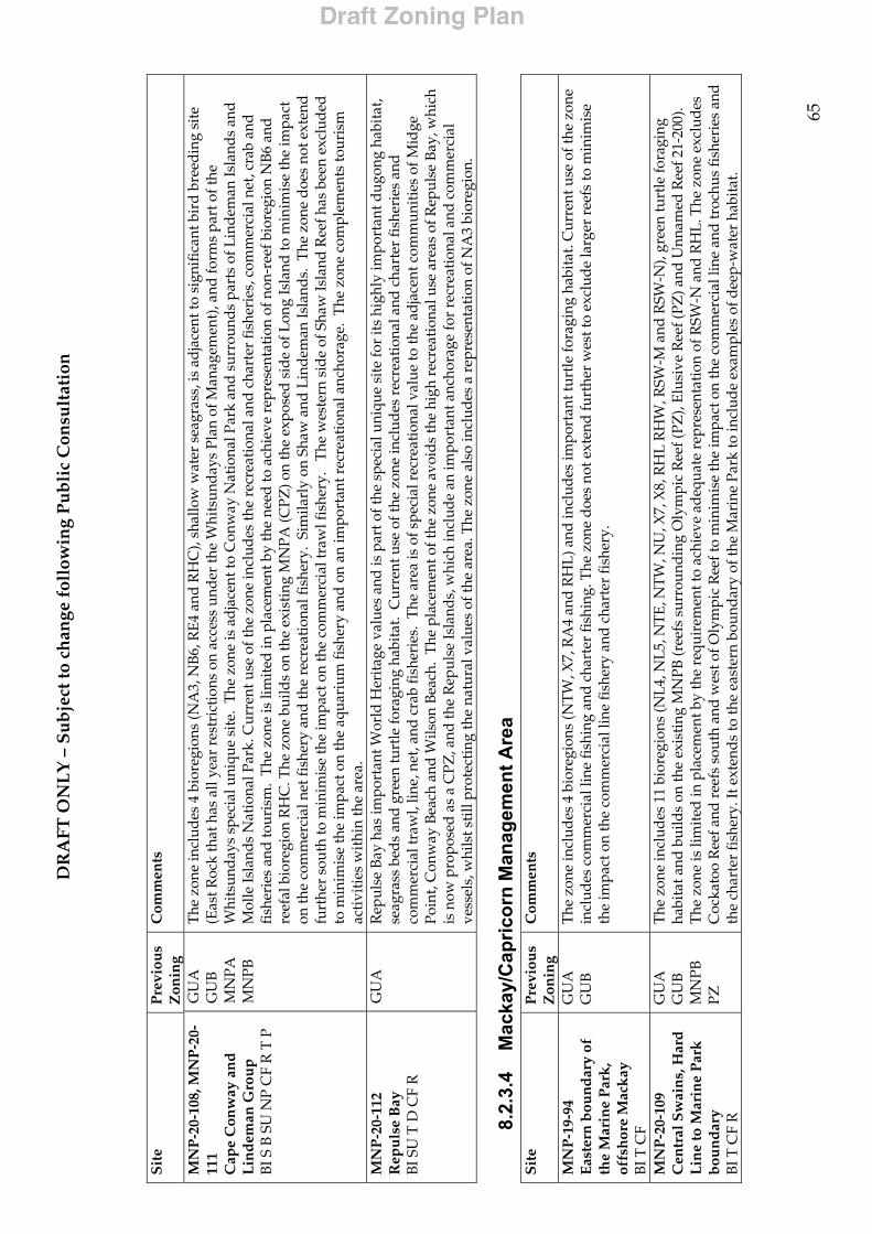
DR
AFT
ON
LY
– S
ub
ject
to c
han
ge f
ollo
win
g P
ub
lic
Con
sult
atio
n
65
S
ite
Pre
viou
s Z
onin
g C
omm
ents
MN
P-2
0-10
8, M
NP
-20-
111
Cap
e C
onw
ay a
nd
L
ind
eman
Gro
up
B
I S B
SU
NP
CF
R T
P
GU
A
GU
B
MN
PA
MN
PB
The
zon
e in
clud
es 4
bio
regi
ons
(NA
3, N
B6,
RE4
and
RH
C),
shal
low
wat
er s
eagr
ass,
is a
dja
cent
to s
igni
fica
nt b
ird
bre
edin
g si
te
(Eas
t Roc
k th
at h
as a
ll ye
ar r
estr
ictio
ns o
n ac
cess
und
er th
e W
hits
und
ays
Plan
of M
anag
emen
t), a
nd fo
rms
part
of t
he
Whi
tsun
day
s sp
ecia
l uni
que
site
. T
he z
one
is a
dja
cent
to C
onw
ay N
atio
nal P
ark
and
sur
roun
ds
part
s of
Lin
dem
an Is
land
s an
d
Mol
le Is
land
s N
atio
nal P
ark.
Cur
rent
use
of t
he z
one
incl
udes
the
recr
eati
onal
and
cha
rter
fish
erie
s, c
omm
erci
al n
et, c
rab
and
fi
sher
ies
and
tour
ism
. T
he z
one
is li
mit
ed in
pla
cem
ent b
y th
e ne
ed to
ach
ieve
rep
rese
ntat
ion
of n
on-r
eef b
iore
gion
NB
6 an
d
reef
al b
iore
gion
RH
C. T
he z
one
build
s on
the
exis
ting
MN
PA (C
PZ) o
n th
e ex
pose
d s
ide
of L
ong
Isla
nd to
min
imis
e th
e im
pact
on
the
com
mer
cial
net
fish
ery
and
the
recr
eati
onal
fish
ery.
Sim
ilarl
y on
Sha
w a
nd L
inde
man
Isla
nds.
The
zon
e d
oes
not e
xten
d
furt
her
sout
h to
min
imis
e th
e im
pact
on
the
com
mer
cial
traw
l fis
hery
. T
he w
este
rn s
ide
of S
haw
Isla
nd R
eef h
as b
een
excl
uded
to
min
imis
e th
e im
pact
on
the
aqua
rium
fish
ery
and
on
an im
port
ant r
ecre
atio
nal a
ncho
rage
. T
he z
one
com
plem
ents
tour
ism
ac
tivi
ties
wit
hin
the
area
. M
NP
-20-
112
Rep
uls
e B
ay
BI S
U T
D C
F R
GU
A
Rep
ulse
Bay
has
impo
rtan
t Wor
ld H
erit
age
valu
es a
nd is
par
t of t
he s
peci
al u
niqu
e si
te fo
r it
s hi
ghly
impo
rtan
t dug
ong
habi
tat,
seag
rass
bed
s an
d gr
een
turt
le fo
ragi
ng h
abit
at.
Cur
rent
use
of t
he z
one
incl
udes
rec
reat
iona
l and
cha
rter
fish
erie
s an
d co
mm
erci
al tr
awl,
line,
net
, and
cra
b fi
sher
ies.
The
are
a is
of s
peci
al r
ecre
atio
nal v
alue
to th
e ad
jace
nt c
omm
unit
ies
of M
idge
Po
int,
Con
way
Bea
ch a
nd W
ilson
Bea
ch.
The
pla
cem
ent o
f the
zon
e av
oid
s th
e hi
gh r
ecre
atio
nal u
se a
reas
of R
epul
se B
ay, w
hich
is
now
pro
pose
d a
s a
CPZ
, and
the
Rep
ulse
Isla
nds,
whi
ch in
clud
e an
impo
rtan
t anc
hora
ge fo
r re
crea
tion
al a
nd c
omm
erci
al
vess
els,
whi
lst s
till
prot
ecti
ng th
e na
tura
l val
ues
of th
e ar
ea. T
he z
one
also
incl
udes
a r
epre
sent
atio
n of
NA
3 bi
oreg
ion.
8.2.
3.4
Mac
kay/
Cap
ricor
n M
anag
emen
t Are
a
Sit
e P
revi
ous
Zon
ing
Com
men
ts
MN
P-1
9-94
E
aste
rn b
oun
dar
y of
th
e M
arin
e P
ark
, of
fsh
ore
Mac
kay
B
I T C
F
GU
A
GU
B
The
zon
e in
clud
es 4
bio
regi
ons
(NT
W, X
7, R
A4
and
RH
L) a
nd in
clud
es im
port
ant t
urtl
e fo
ragi
ng h
abita
t. C
urre
nt u
se o
f the
zon
e in
clud
es c
omm
erci
al li
ne fi
shin
g an
d ch
arte
r fi
shin
g. T
he z
one
doe
s no
t ext
end
furt
her
wes
t to
excl
ude
larg
er r
eefs
to m
inim
ise
the
impa
ct o
n th
e co
mm
erci
al li
ne fi
sher
y an
d c
hart
er fi
sher
y.
MN
P-2
0-10
9 C
entr
al S
wai
ns,
Har
d
Lin
e to
Mar
ine
Par
k
bou
nd
ary
BI T
CF
R
GU
A
GU
B
MN
PB
PZ
The
zon
e in
clud
es 1
1 bi
oreg
ions
(NL
4, N
L5,
NT
E, N
TW
, NU
, X7,
X8,
RH
L R
HW
, RSW
-M a
nd R
SW-N
), gr
een
turt
le fo
ragi
ng
habi
tat a
nd b
uild
s on
the
exis
ting
MN
PB (r
eefs
sur
roun
din
g O
lym
pic
Ree
f (PZ
), E
lusi
ve R
eef (
PZ) a
nd U
nnam
ed R
eef 2
1-20
0).
The
zon
e is
lim
ited
in p
lace
men
t by
the
requ
irem
ent t
o ac
hiev
e ad
equa
te r
epre
sent
atio
n of
RSW
-N a
nd R
HL
. The
zon
e ex
clud
es
Coc
kato
o R
eef a
nd r
eefs
sou
th a
nd w
est o
f Oly
mpi
c R
eef t
o m
inim
ise
the
impa
ct o
n th
e co
mm
erci
al li
ne a
nd tr
ochu
s fi
sher
ies
and
th
e ch
arte
r fi
sher
y. It
ext
ends
to th
e ea
ster
n bo
unda
ry o
f the
Mar
ine
Park
to in
clud
e ex
ampl
es o
f dee
p-w
ater
hab
itat.
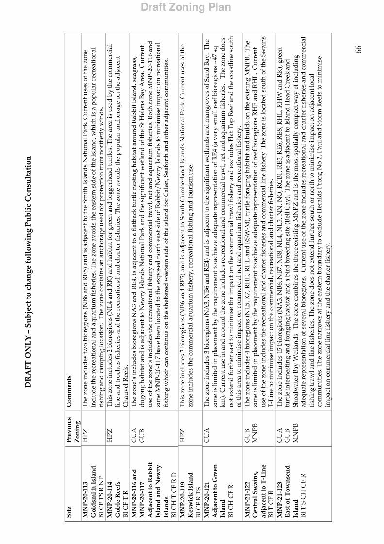
DR
AFT
ON
LY
– S
ub
ject
to c
han
ge f
ollo
win
g P
ub
lic
Con
sult
atio
n
66
S
ite
Pre
viou
s Z
onin
g C
omm
ents
MN
P-2
0-11
3 G
old
smit
h I
slan
d
BI C
F T
S R
NP
HPZ
T
he z
one
incl
udes
two
bior
egio
ns (N
B6 a
nd R
E5) a
nd is
ad
jace
nt to
the
Smit
h Is
land
s N
atio
nal P
ark.
Cur
rent
use
s of
the
zone
in
clud
e th
e re
crea
tion
al a
nd a
quar
ium
fish
erie
s. T
he z
one
avoi
ds
the
east
ern
sid
e of
the
Isla
nd, w
hich
is a
pop
ular
rec
reat
iona
l fi
shin
g an
d ca
mpi
ng lo
cati
on.
The
zon
e co
ntai
ns a
n an
chor
age
used
for
prot
ecti
on fr
om n
orth
erly
win
ds.
MN
P-2
0-11
4 G
oble
Ree
fs
BI C
F T
R
HPZ
T
his
zone
incl
udes
2 b
iore
gion
s (N
L4 a
nd R
K) a
nd h
abit
at fo
r gr
een
and
logg
erhe
ad tu
rtle
s. T
he a
rea
is u
sed
by
the
com
mer
cial
lin
e an
d tr
ochu
s fi
sher
ies
and
the
recr
eati
onal
and
cha
rter
fish
erie
s. T
he z
one
avoi
ds
the
popu
lar
anch
orag
e on
the
adja
cent
C
hauv
el R
eefs
. M
NP
-20-
116
and
M
NP
-20-
117
Ad
jace
nt t
o R
abb
it
Isla
nd
an
d N
ewry
Is
lan
ds
BI C
H T
CF
R D
GU
A
GU
B
The
zon
e’s
incl
udes
bio
regi
ons
NA
3 an
d R
E4, i
s ad
jace
nt to
a fl
atba
ck tu
rtle
nes
ting
hab
itat
aro
und
Rab
bit I
slan
d, s
eagr
ass,
d
ugon
g ha
bita
t and
is a
dja
cent
to N
ewry
Isla
nds
Nat
iona
l Par
k an
d th
e si
gnif
ican
t wet
land
of t
he S
t Hel
ens
Bay
Are
a. C
urre
nt
use
of th
e zo
ne’s
incl
udes
the
recr
eati
onal
fish
ery
and
com
mer
cial
traw
l, ne
t and
aqu
ariu
m fi
sher
ies.
Bot
h zo
ne M
NP-
20-1
16 a
nd
zone
MN
P-20
-117
hav
e be
en lo
cate
d to
the
expo
sed
nort
h ea
st s
ide
of R
abbi
t/N
ewry
Isla
nds
to m
inim
ise
impa
ct o
n re
crea
tion
al
fish
ing
whi
ch c
an c
ontin
ue o
n th
e sh
elte
red
wes
tern
sid
e of
the
isla
nd fo
r C
alen
, Sea
fort
h an
d o
ther
ad
jace
nt c
omm
unit
ies.
MN
P-2
0-11
9 K
esw
ick
Isl
and
B
I CF
R T
S
HPZ
T
his
zone
incl
udes
2 b
iore
gion
s (N
B6 a
nd R
E5) a
nd is
ad
jace
nt to
Sou
th C
umbe
rlan
d Is
land
s N
atio
nal P
ark.
Cur
rent
use
s of
the
zone
incl
udes
the
com
mer
cial
aqu
ariu
m fi
sher
y, r
ecre
atio
nal f
ishi
ng a
nd to
uris
m u
se.
MN
P-2
0-12
1 A
dja
cen
t to
Gre
en
Isla
nd
B
I CH
CF
R
GU
A
The
zon
e in
clud
es 3
bio
regi
ons
(NA
3, N
B6
and
RE4
) and
is a
dja
cent
to th
e si
gnif
ican
t wet
land
s an
d m
angr
oves
of S
and
Bay
. Th
e zo
ne is
lim
ited
in p
lace
men
t by
the
requ
irem
ent t
o ac
hiev
e ad
equa
te r
epre
sent
atio
n of
RE4
(a v
ery
smal
l ree
f bio
regi
ons
~47
sq
km).
Cur
rent
use
in a
nd a
roun
d th
e zo
ne in
clud
es r
ecre
atio
nal a
nd c
omm
erci
al tr
awl,
net a
nd a
quar
ium
fish
erie
s.
The
zon
e d
oes
not e
xten
d fu
rthe
r ea
st to
min
imis
e th
e im
pact
on
the
com
mer
cial
traw
l fis
hery
and
exc
lud
es F
lat T
op R
eef a
nd th
e co
astl
ine
sout
h of
this
are
a to
min
imis
e im
pact
on
com
mer
cial
net
and
aqu
ariu
m fi
sher
ies
and
rec
reat
iona
l fis
hery
. M
NP
-21-
122
Cen
tral
Sw
ain
s,
adja
cen
t to
T-L
ine
BI T
CF
R
GU
B
MN
PB
The
zon
e in
clud
es 4
bio
regi
ons
(NL5
, X7,
RH
E, R
HL
and
RSW
-M),
turt
le fo
ragi
ng h
abita
t and
bui
lds
on th
e ex
isti
ng M
NPB
. T
he
zone
is li
mit
ed in
pla
cem
ent b
y th
e re
quir
emen
t to
achi
eve
adeq
uate
rep
rese
ntat
ion
of r
eef b
iore
gion
s R
HE
and
RH
L.
Cur
rent
us
e of
the
zone
incl
udes
the
recr
eati
onal
and
cha
rter
fish
erie
s an
d co
mm
erci
al li
ne fi
sher
y. T
he z
one
is lo
cate
d s
outh
of t
he S
wai
ns
T-L
ine
to m
inim
ise
impa
ct o
n th
e co
mm
erci
al, r
ecre
atio
nal a
nd c
hart
er fi
sher
ies.
M
NP
-21-
123
Eas
t of
Tow
nse
nd
Is
lan
d
BI T
S C
H C
F R
GU
A
GU
B
MN
PB
The
zon
e in
clud
es 1
5 bi
oreg
ions
(NA
3, N
B6,
NB
7, N
B8,
NL4
, NL5
, NN
, NO
, RC
B1,
RE5
, RE6
, RE8
, RH
L, R
HW
and
RK
), gr
een
turt
le in
tern
esti
ng a
nd fo
ragi
ng h
abit
at a
nd a
bir
d br
eedi
ng s
ite
(Bel
l Cay
). T
he z
one
is a
dja
cent
to Is
land
Hea
d C
reek
and
Sh
oalw
ater
Bay
Wet
land
s. T
he z
one
com
bine
s th
e th
ree
exis
ting
MN
PZ a
nd is
the
mos
t spa
tial
ly c
ompa
ct w
ay o
f inc
lud
ing
adeq
uate
rep
rese
ntat
ion
of s
ever
al b
iore
gion
s. C
urre
nt u
se o
f the
zon
e in
clud
es r
ecre
atio
nal a
nd c
hart
er fi
sher
ies
and
com
mer
cial
fi
shin
g tr
awl a
nd li
ne fi
sher
ies.
The
zon
e d
oes
not e
xten
d fu
rthe
r so
uth
or n
orth
to m
inim
ise
impa
ct o
n ad
jace
nt lo
cal
com
mun
itie
s. T
he z
one
narr
ows
at th
e ea
ster
n bo
unda
ry to
exc
lud
e H
eral
ds
Pron
g N
o 2,
Pau
l and
Sto
rm R
eefs
to m
inim
ise
impa
ct o
n co
mm
erci
al li
ne fi
sher
y an
d th
e ch
arte
r fi
sher
y.
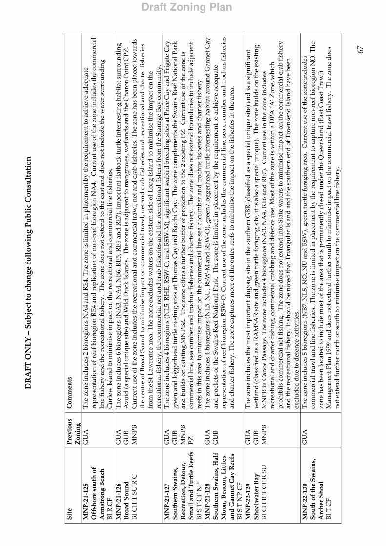
DR
AFT
ON
LY
– S
ub
ject
to c
han
ge f
ollo
win
g P
ub
lic
Con
sult
atio
n
67
S
ite
Pre
viou
s Z
onin
g C
omm
ents
MN
P-2
1-12
5 O
ffsh
ore
sou
th o
f A
rmst
ron
g B
each
B
I R C
F
GU
A
The
zon
e in
clud
es 2
bio
regi
ons
NA
4 an
d R
E4. T
he z
one
is li
mit
ed in
pla
cem
ent b
y th
e re
quir
emen
t to
achi
eve
adeq
uate
re
pres
enta
tion
of r
eef b
iore
gion
RE4
and
rep
licat
ion
of n
on-r
eef b
iore
gion
NA
4.
Cur
rent
use
of t
he z
one
incl
udes
the
com
mer
cial
lin
e fi
sher
y an
d th
e re
crea
tion
al fi
sher
y. T
he z
one
doe
s no
t ext
end
to th
e ea
st a
nd d
oes
not i
nclu
de th
e w
ater
sur
roun
ding
C
urle
w Is
land
to m
inim
ise
impa
ct o
n th
e re
crea
tion
al a
nd c
omm
erci
al li
ne fi
sher
ies.
M
NP
-21-
126
Bro
ad S
oun
d
BI C
H T
SU
R C
GU
A
GU
B
MN
PB
The
zon
e in
clud
es 6
bio
regi
ons
(NA
3, N
A4,
NB6
, RE
5, R
E6
and
RE7
), im
port
ant f
latb
ack
turt
le in
tern
esti
ng h
abit
at s
urro
undi
ng
Avo
id (a
spe
cial
uni
que
site
) and
Wild
Duc
k Is
land
s. T
he z
one
is a
dja
cent
to m
angr
oves
, wet
land
s an
d th
e C
haro
n Po
int C
PZ.
Cur
rent
use
of t
he z
one
incl
udes
the
recr
eati
onal
and
com
mer
cial
traw
l, ne
t and
cra
b fi
sher
ies.
The
zon
e ha
s be
en p
lace
d to
war
ds
the
cent
re o
f Bro
ad S
ound
to m
inim
ise
impa
ct o
n co
mm
erci
al tr
awl,
net a
nd c
rab
fish
erie
s an
d r
ecre
atio
nal a
nd c
hart
er fi
sher
ies
from
the
St L
awre
nce
area
. The
zon
e ex
clud
es w
ater
s on
the
east
ern
side
of L
ong
Isla
nd to
min
imis
e th
e im
pact
on
the
recr
eati
onal
fish
ery,
the
com
mer
cial
net
and
cra
b fi
sher
ies
and
the
recr
eati
onal
fish
ers
from
the
Stan
age
Bay
com
mun
ity.
M
NP
-21-
127
Sou
ther
n S
wai
ns,
R
ecre
atio
n, D
etou
r,
Sm
all a
nd
Tu
rtle
Ree
fs
BI S
T C
F N
P
GU
A
GU
B
MN
PB
PZ
The
zon
e in
clud
es 4
bio
regi
ons
(NL5
, RH
E, R
SW-O
, and
RSW
-M),
sign
ific
ant s
eabi
rd b
reed
ing
site
s at
Pri
ce C
ay a
nd F
riga
te C
ay,
gree
n an
d lo
gger
head
turt
le n
esti
ng s
ites
at T
hom
as C
ay a
nd B
acch
i Cay
. T
he z
one
com
plem
ents
the
Swai
ns R
eef N
atio
nal P
ark
and
bui
lds
on e
xist
ing
MN
PBZ
. T
he z
one
offe
rs a
furt
her
buff
er o
f pro
tect
ion
to th
e 2
exis
ting
PZ
. C
urre
nt u
se o
f the
zon
e is
co
mm
erci
al li
ne, s
ea c
umbe
r an
d tr
ochu
s fi
sher
ies
and
cha
rter
fish
ery.
The
zon
e d
oes
not e
xten
d b
ound
arie
s to
incl
ude
adja
cent
re
efs
in th
is a
rea
to m
inim
ise
impa
ct o
n th
e co
mm
erci
al li
ne s
ea c
ucum
ber
and
troc
hus
fish
erie
s an
d c
hart
er fi
sher
y.
MN
P-2
1-12
8 S
outh
ern
Sw
ain
s, H
alf
Moo
n, B
eaco
n, L
ittl
es
and
Gan
net
Cay
Ree
fs
BI S
T N
P C
F
GU
A
GU
B
The
zon
e in
clud
es 4
bio
regi
ons
(NL5
, NU
, RSW
-M a
nd R
SW-O
), gr
een/
logg
erhe
ad tu
rtle
inte
rnes
ting
hab
itat a
roun
d G
anne
t Cay
an
d p
ocke
ts o
f the
Sw
ains
Ree
f Nat
iona
l Par
k. T
he z
one
is li
mit
ed in
pla
cem
ent b
y th
e re
quir
emen
t to
achi
eve
adeq
uate
re
pres
enta
tion
of r
eef b
iore
gion
RSW
-O. C
urre
nt u
se o
f the
zon
e in
clud
es th
e co
mm
erci
al li
ne, s
ea c
ucum
ber
and
troc
hus
fish
erie
s an
d c
hart
er fi
sher
y. T
he z
one
capt
ures
mor
e of
the
oute
r re
efs
to m
inim
ise
the
impa
ct o
n th
e fi
sher
ies
in th
e ar
ea.
MN
P-2
2-12
9 S
hoa
lwat
er B
ay
BI C
H B
T C
F R
SU
GU
A
GU
B
MN
PB
The
zon
e in
clud
es th
e m
ost i
mpo
rtan
t dug
ong
site
in th
e so
uthe
rn G
BR
(cla
ssif
ied
as
a sp
ecia
l uni
que
site
) and
is a
sig
nifi
cant
w
etla
nd (c
lass
ifie
d as
a R
AM
SAR
sit
e an
d g
reen
turt
le fo
ragi
ng s
ite, i
t is
also
a s
peci
al u
niqu
e).
The
zon
e bu
ilds
on th
e ex
isti
ng
MN
PB in
Can
oe P
assa
ge. T
he z
one
incl
udes
4 b
iore
gion
s (N
A3,
NA
4, R
E6
and
RE7
). C
urre
nt u
se in
the
zone
incl
udes
re
crea
tion
al a
nd c
hart
er fi
shin
g, c
omm
erci
al c
rabb
ing
and
def
ence
use
. Mos
t of t
he z
one
is w
ithin
a D
PA ‘A
’ Zon
e, w
hich
pr
ohib
its
com
mer
cial
net
fish
ing.
The
zon
e d
oes
not e
xten
d in
to S
tate
wat
ers
to m
inim
ise
impa
ct o
n th
e co
mm
erci
al c
rab
fish
ery
and
the
recr
eati
onal
fish
ery.
It s
houl
d be
not
ed th
at T
rian
gula
r Is
land
and
the
sout
hern
end
of T
owns
end
Isla
nd h
ave
been
ex
clud
ed d
ue to
def
ence
act
ivit
ies.
M
NP
-22-
130
Sou
th o
f th
e S
wai
ns,
A
rch
er S
hoa
l B
I T C
F
GU
A
The
zone
incl
udes
5 b
iore
gion
s (N
B7, N
L5, N
O, N
U a
nd R
SW),
gree
n tu
rtle
fora
ging
are
a. C
urre
nt u
se o
f the
zon
e in
clud
es
com
mer
cial
traw
l and
line
fish
erie
s. T
he z
one
is li
mit
ed in
pla
cem
ent b
y th
e re
quir
emen
t to
capt
ure
non-
reef
bio
regi
on N
O. T
he
zone
has
bee
n lo
cate
d to
incl
ude
mos
t of t
he a
rea
that
is p
erm
anen
tly
clos
ed u
nder
the
Que
ensl
and
(Eas
t Coa
st T
raw
l)
Man
agem
ent P
lan
1999
and
doe
s no
t ext
end
furt
her
sout
h to
min
imis
e im
pact
on
the
com
mer
cial
traw
l fis
hery
. T
he z
one
doe
s no
t ext
end
furt
her
nort
h or
sou
th to
min
imis
e im
pact
on
the
com
mer
cial
line
fish
ery.
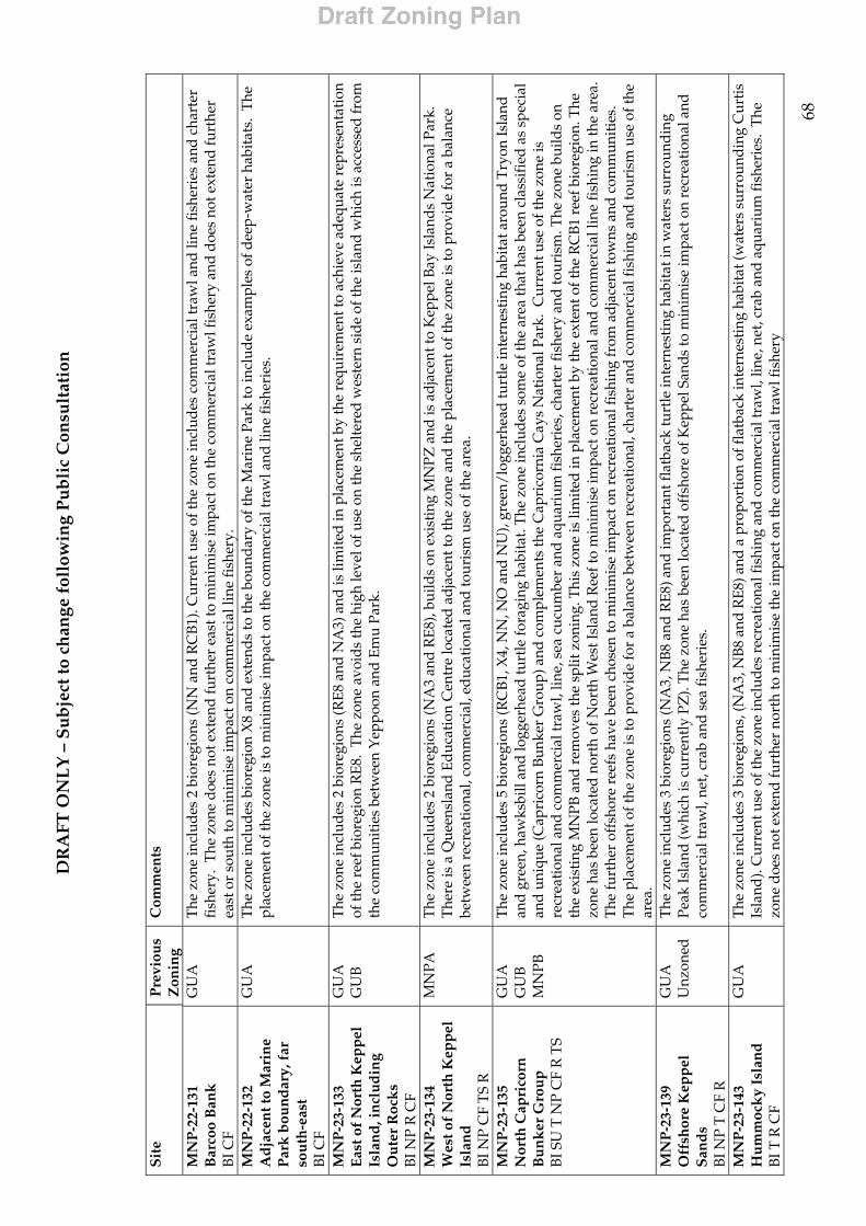
DR
AFT
ON
LY
– S
ub
ject
to c
han
ge f
ollo
win
g P
ub
lic
Con
sult
atio
n
68
S
ite
Pre
viou
s Z
onin
g C
omm
ents
MN
P-2
2-13
1 B
arco
o B
ank
B
I CF
GU
A
The
zon
e in
clud
es 2
bio
regi
ons
(NN
and
RC
B1).
Cur
rent
use
of t
he z
one
incl
udes
com
mer
cial
traw
l and
line
fish
erie
s an
d c
hart
er
fish
ery.
The
zon
e d
oes
not e
xten
d fu
rthe
r ea
st to
min
imis
e im
pact
on
the
com
mer
cial
traw
l fis
hery
and
doe
s no
t ext
end
furt
her
east
or
sout
h to
min
imis
e im
pact
on
com
mer
cial
line
fish
ery.
M
NP
-22-
132
Ad
jace
nt t
o M
arin
e P
ark
bou
nd
ary,
far
so
uth
-eas
t B
I CF
GU
A
The
zon
e in
clud
es b
iore
gion
X8
and
ext
end
s to
the
boun
dar
y of
the
Mar
ine
Park
to in
clud
e ex
ampl
es o
f dee
p-w
ater
hab
itats
. T
he
plac
emen
t of t
he z
one
is to
min
imis
e im
pact
on
the
com
mer
cial
traw
l and
line
fish
erie
s.
MN
P-2
3-13
3 E
ast o
f N
orth
Kep
pel
Is
lan
d, i
ncl
ud
ing
Ou
ter
Roc
ks
BI N
P R
CF
GU
A
GU
B
The
zon
e in
clud
es 2
bio
regi
ons
(RE
8 an
d N
A3)
and
is li
mit
ed in
pla
cem
ent b
y th
e re
quir
emen
t to
achi
eve
adeq
uate
rep
rese
ntat
ion
of th
e re
ef b
iore
gion
RE8
. T
he z
one
avoi
ds
the
high
leve
l of u
se o
n th
e sh
elte
red
wes
tern
sid
e of
the
isla
nd w
hich
is a
cces
sed
from
th
e co
mm
unit
ies
betw
een
Yep
poon
and
Em
u Pa
rk.
MN
P-2
3-13
4 W
est o
f N
orth
Kep
pel
Is
lan
d
BI N
P C
F T
S R
MN
PA
The
zon
e in
clud
es 2
bio
regi
ons
(NA
3 an
d R
E8),
build
s on
exi
stin
g M
NPZ
and
is a
dja
cent
to K
eppe
l Bay
Isla
nds
Nat
iona
l Par
k.
The
re is
a Q
ueen
slan
d E
duc
atio
n C
entr
e lo
cate
d ad
jace
nt to
the
zone
and
the
plac
emen
t of t
he z
one
is to
pro
vid
e fo
r a
bala
nce
betw
een
recr
eati
onal
, com
mer
cial
, ed
ucat
iona
l and
tour
ism
use
of t
he a
rea.
MN
P-2
3-13
5 N
orth
Cap
rico
rn
Bu
nk
er G
rou
p
BI S
U T
NP
CF
R T
S
GU
A
GU
B
MN
PB
The
zon
e in
clud
es 5
bio
regi
ons
(RC
B1, X
4, N
N, N
O a
nd N
U),
gree
n/lo
gger
head
turt
le in
tern
esti
ng h
abit
at a
roun
d T
ryon
Isla
nd
and
gre
en, h
awks
bill
and
logg
erhe
ad tu
rtle
fora
ging
hab
itat
. The
zon
e in
clud
es s
ome
of th
e ar
ea th
at h
as b
een
clas
sifi
ed a
s sp
ecia
l an
d u
niqu
e (C
apri
corn
Bun
ker
Gro
up) a
nd c
ompl
emen
ts th
e C
apri
corn
ia C
ays
Nat
iona
l Par
k. C
urre
nt u
se o
f the
zon
e is
re
crea
tion
al a
nd c
omm
erci
al tr
awl,
line,
sea
cuc
umbe
r an
d aq
uari
um fi
sher
ies,
cha
rter
fish
ery
and
tour
ism
. The
zon
e bu
ilds
on
the
exis
ting
MN
PB a
nd r
emov
es th
e sp
lit z
onin
g. T
his
zone
is li
mit
ed in
pla
cem
ent b
y th
e ex
tent
of t
he R
CB1
ree
f bio
regi
on. T
he
zone
has
bee
n lo
cate
d n
orth
of N
orth
Wes
t Isl
and
Ree
f to
min
imis
e im
pact
on
recr
eati
onal
and
com
mer
cial
line
fish
ing
in th
e ar
ea.
The
furt
her
offs
hore
ree
fs h
ave
been
cho
sen
to m
inim
ise
impa
ct o
n re
crea
tion
al fi
shin
g fr
om a
dja
cent
tow
ns a
nd c
omm
unit
ies.
T
he p
lace
men
t of t
he z
one
is to
pro
vid
e fo
r a
bala
nce
betw
een
recr
eati
onal
, cha
rter
and
com
mer
cial
fish
ing
and
tour
ism
use
of t
he
area
. M
NP
-23-
139
Off
shor
e K
epp
el
San
ds
BI N
P T
CF
R
GU
A
Unz
oned
T
he z
one
incl
udes
3 b
iore
gion
s (N
A3,
NB
8 an
d R
E8) a
nd im
port
ant f
latb
ack
turt
le in
tern
esti
ng h
abit
at in
wat
ers
surr
ound
ing
Peak
Isla
nd (w
hich
is c
urre
ntly
PZ
). T
he z
one
has
been
loca
ted
off
shor
e of
Kep
pel S
ands
to m
inim
ise
impa
ct o
n re
crea
tion
al a
nd
com
mer
cial
traw
l, ne
t, cr
ab a
nd s
ea fi
sher
ies.
MN
P-2
3-14
3 H
um
moc
ky
Isla
nd
BI
T R
CF
GU
A
The
zon
e in
clud
es 3
bio
regi
ons,
(NA
3, N
B8
and
RE8
) and
a p
ropo
rtio
n of
flat
back
inte
rnes
ting
hab
itat (
wat
ers
surr
ound
ing
Cur
tis
Isla
nd).
Cur
rent
use
of t
he z
one
incl
udes
rec
reat
iona
l fis
hing
and
com
mer
cial
traw
l, lin
e, n
et, c
rab
and
aqua
rium
fish
erie
s. T
he
zone
doe
s no
t ext
end
furt
her
nort
h to
min
imis
e th
e im
pact
on
the
com
mer
cial
traw
l fis
hery

DR
AFT
ON
LY
– S
ub
ject
to c
han
ge f
ollo
win
g P
ub
lic
Con
sult
atio
n
69
Sit
e P
revi
ous
Zon
ing
Com
men
ts
MN
P-2
3-14
2 W
reck
Isl
and
B
I CF
R S
U T
HPZ
T
his
zone
incl
udes
bio
regi
on X
4, p
rovi
des
a b
uffe
r fo
r th
e PZ
aro
und
Wre
ck Is
land
, for
ms
part
of t
he C
apri
corn
Bun
ker
Gro
up
and
the
Wre
ck Is
land
spe
cial
and
uni
que
site
s an
d h
as g
reen
, log
gerh
ead
and
haw
ksbi
ll tu
rtle
inte
rnes
ting
. Cur
rent
use
of t
he
zone
incl
udes
rec
reat
iona
l and
cha
rter
fish
erie
s.
MN
P-2
3-14
4 S
outh
of
Wis
tari
Ree
f an
d H
eron
Isl
and
B
I SU
T S
CF
TS
R
GU
A
GU
B
MN
PB
The
zon
e in
clud
es 6
bio
regi
ons
(NB8
, NU
, X4,
X8,
RC
B1
and
RC
B2),
gree
n an
d lo
gger
head
turt
le in
tern
esti
ng h
abit
at (w
ater
s su
rrou
ndin
g M
asth
ead
, Ers
kine
and
Her
on Is
land
s). T
he z
one
incl
udes
som
e of
the
area
that
has
bee
n cl
assi
fied
as
spec
ial a
nd
uniq
ue (C
apri
corn
Bun
ker
Gro
up) a
nd c
ompl
emen
ts th
e C
apri
corn
ia C
ays
Nat
iona
l Par
k an
d ex
isti
ng s
easo
nal c
losu
res
for
bird
br
eed
ing
popu
lati
ons.
The
zon
e bu
ilds
on th
e ex
isti
ng s
plit
zon
ing
on W
ista
ri R
eef a
nd M
asth
ead
Ree
f, pr
ovid
ing
mor
e ad
equa
te
prot
ecti
on.
Cur
rent
use
of t
he z
one
incl
udes
the
recr
eati
onal
and
cha
rter
fish
erie
s an
d co
mm
erci
al li
ne a
nd a
quar
ium
fish
erie
s.
The
zon
e is
lim
ited
in p
lace
men
t by
the
smal
l ree
fal b
iore
gion
RC
B2 (~
45 s
q km
). T
he p
lace
men
t of t
he z
one
is to
pro
vid
e fo
r a
bala
nce
betw
een
recr
eati
onal
, com
mer
cial
fish
ing
and
tour
ism
use
of t
he a
rea.
M
NP
-23-
145
Nor
th-e
aste
rn s
trip
of
coas
tal w
ater
s ad
jace
nt
to C
urt
is I
slan
d
BI N
P T
B C
F R
GU
A
The
zon
e in
clud
es b
iore
gion
NA
3, s
eagr
ass,
and
a p
ropo
rtio
n of
impo
rtan
t fla
tbac
k tu
rtle
inte
rnes
ting
hab
itat
aro
und
Cur
tis
Isla
nd. T
he z
one
is a
dja
cent
to C
urti
s Is
land
Nat
iona
l Par
k an
d m
angr
oves
are
in th
e ar
ea.
Cur
rent
use
in th
e zo
ne in
clud
es
recr
eati
onal
and
com
mer
cial
traw
l, lin
e, n
et, c
rab
and
aqua
rium
fish
erie
s. T
he z
one
has
been
pla
ced
on
the
mor
e ex
pose
d s
ide
of
Cur
tis
isla
nd to
min
imis
e im
pact
on
the
recr
eati
onal
and
com
mer
cial
fish
erie
s, w
ith
cons
ider
atio
n fo
r th
e m
ajor
pop
ulat
ion
cent
res
of R
ockh
ampt
on, G
lad
ston
e an
d a
dja
cent
com
mun
itie
s. T
he z
one
doe
s no
t ext
end
furt
her
east
to m
inim
ise
impa
ct o
n th
e co
mm
erci
al tr
awl a
nd li
ne fi
sher
ies.
The
zon
e ex
clud
es R
undl
e R
eef a
nd B
ass
Shoa
ls to
min
imis
e im
pact
on
the
recr
eati
onal
fi
sher
y an
d th
e co
mm
erci
al li
ne a
nd a
quar
ium
fish
ery.
M
NP
-23-
146
Sou
th C
apri
corn
B
un
ker
Gro
up
B
I S S
U T
CF
R T
S
GU
A
GU
B
MN
PA
MN
PB
The
zon
e in
clud
es 5
bio
regi
ons
(NB8
, NU
, X4,
X8
and
RC
B1),
gree
n an
d lo
gger
head
turt
le in
tern
esti
ng h
abita
t, (w
ater
s su
rrou
ndin
g L
ady
Elli
ot, H
osky
n an
d M
usgr
ave
Isla
nds)
and
incl
udes
sig
nifi
cant
bir
d br
eed
ing
site
s. T
he z
one
incl
udes
som
e of
th
e ar
ea th
at h
as b
een
clas
sifi
ed a
s sp
ecia
l and
uni
que
(Cap
rico
rn B
unke
r G
roup
) and
com
plem
ents
the
Cap
rico
rnia
Cay
s N
atio
nal P
ark.
The
zon
e bu
ilds
on th
e ex
isti
ng M
NPB
(Lle
wel
lyn
Ree
f) a
nd M
NPA
ree
fs (L
ady
Elli
ot Is
land
Ree
f).
The
zon
e is
lim
ited
in p
lace
men
t by
requ
irem
ent t
o ac
hiev
e ad
equa
te p
rote
ctio
n of
the
non-
reef
bio
regi
ons
NB8
. Cur
rent
use
in th
e zo
ne
incl
udes
the
recr
eati
onal
and
cha
rter
fish
erie
s, c
omm
erci
al tr
awl,
line,
spa
nner
cra
b an
d a
quar
ium
fish
erie
s an
d to
uris
m.
The
zo
ne e
xclu
des
Lad
y M
usgr
ave
Ree
f and
Isla
nd to
min
imis
e im
pact
on
recr
eati
onal
and
com
mer
cial
line
, sea
cuc
umbe
r an
d
aqua
rium
fish
erie
s an
d do
es n
ot e
xten
d fu
rthe
r to
the
wes
t to
min
imis
e im
pact
on
the
com
mer
cial
traw
l and
spa
nner
cra
b fi
sher
ies.
M
NP
-24-
148
Coa
stal
str
ip s
outh
of
Agn
es W
ater
s B
I NP
SU C
F R
GU
A
T
he z
one
incl
udes
2 b
iore
gion
s (N
A3
and
RE8
), in
clud
es th
e sp
ecia
l uni
que
site
Rou
nd H
ead
to W
reck
Roc
k an
d is
ad
jace
nt to
D
eep
Wat
er N
atio
nal P
ark.
Cur
rent
use
in th
e zo
ne in
clud
es r
ecre
atio
nal a
nd c
omm
erci
al fi
shin
g (t
raw
l and
net
indu
stri
es).
The
zo
ne d
oes
not e
xten
d fu
rthe
r of
fsho
re to
min
imis
e th
e im
pact
on
com
mer
cial
traw
l ind
ustr
y.
MN
P-2
4-14
9 U
nn
amed
Ree
f 24
-010
B
I CF
GU
A
The
zon
e in
clud
es 3
bio
regi
ons
(RC
B1, N
B8
and
X8)
. C
urre
nt u
se in
the
zone
incl
udes
the
com
mer
cial
traw
l, lin
e, c
rab
fish
erie
s.
The
zon
e w
as p
lace
d to
incl
ude
NB8
and
doe
s no
t ext
end
furt
her
wes
t to
min
imis
e im
pact
on
the
traw
l and
spa
nner
cra
b fi
sher
ies.
The
zon
e d
oes
not e
xten
d fu
rthe
r no
rth
to m
inim
ise
impa
ct o
n th
e co
mm
erci
al li
ne fi
sher
y.

DRAFT ONLY – Subject to change following Public Consultation
70
8.3 Buffer Zone
8.3.1 Objectives Provides for appreciation and enjoyment of areas in a relatively undisturbed state but recognises the importance of gamefishing and certain types of commercial line fishing within these areas. Accordingly, trolling for pelagic species is allowed. Some changes have been made to the provisions of the BZ, see Sections 7.1 (Recreational fishing activities) and 7.2 (Commercial fishing activities) for details of these changes. Table 10: Change in the total area of BZ for the Draft Zoning Plan.
Section of Marine Park Zoning Plan Buffer Zone in sq kms (%)
Reef-wide Draft Zoning Plan in sq kms (%)
Far Northern Management Area FNSZP 2002 152 (<1%) 15 (<1%) Cairns/Cooktown Management Area
Cairns Section ZP 1992
355 (1%) 2476 (7%)
Townsville/Whitsundays Management Area
Central Section ZP 1987
N/A N/A
Mackay/Capricorn Management Area
Mac/Cap Section ZP 1987 & GWSZP 2002
N/A
N/A
N/A
N/A
8.3.2 Placement of the Buffer Zone Zone placement in previous Zoning Plans The objectives of the BZ within these Sections were to allow for trolling for pelagic species, in areas surrounding reefs zoned National Park or PZ. This Zone allowed these activities to be undertaken in the area between the reef edge and the reef crest. Zone Placement Guidelines for the Draft Zoning Plan
• Recommends where possible, that areas important for gamefishing competition be zoned no more than BZ where surrounding reefs or waters are MNPZ or PZ ; and
• Provide for future conservation in areas where there are presently few activities.
8.3.3 Examples of Buffer Zone within the Draft Zoning Plan Site Previous
Zoning Comments
B-14-160 Adjacent to Marine Park boundary, east of Yonge and Carter Reefs CF R TS
HPZ This area is of high natural value and is proposed between the boundary of the Marine Park and Carter and Yonge Reefs. This zoning complements the areas importance to the charter fisheries while maintaining the conservation values of the area.
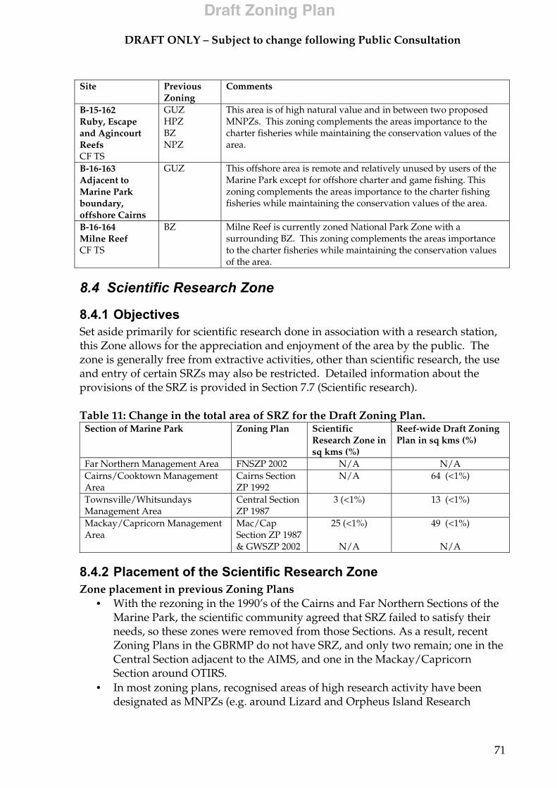
DRAFT ONLY – Subject to change following Public Consultation
71
Site Previous
Zoning Comments
B-15-162 Ruby, Escape and Agincourt Reefs CF TS
GUZ HPZ BZ NPZ
This area is of high natural value and in between two proposed MNPZs. This zoning complements the areas importance to the charter fisheries while maintaining the conservation values of the area.
B-16-163 Adjacent to Marine Park boundary, offshore Cairns
GUZ
This offshore area is remote and relatively unused by users of the Marine Park except for offshore charter and game fishing. This zoning complements the areas importance to the charter fishing fisheries while maintaining the conservation values of the area.
B-16-164 Milne Reef CF TS
BZ
Milne Reef is currently zoned National Park Zone with a surrounding BZ. This zoning complements the areas importance to the charter fisheries while maintaining the conservation values of the area.
8.4 Scientific Research Zone
8.4.1 Objectives Set aside primarily for scientific research done in association with a research station, this Zone allows for the appreciation and enjoyment of the area by the public. The zone is generally free from extractive activities, other than scientific research, the use and entry of certain SRZs may also be restricted. Detailed information about the provisions of the SRZ is provided in Section 7.7 (Scientific research). Table 11: Change in the total area of SRZ for the Draft Zoning Plan.
Section of Marine Park Zoning Plan Scientific Research Zone in sq kms (%)
Reef-wide Draft Zoning Plan in sq kms (%)
Far Northern Management Area FNSZP 2002 N/A N/A Cairns/Cooktown Management Area
Cairns Section ZP 1992
N/A 64 (<1%)
Townsville/Whitsundays Management Area
Central Section ZP 1987
3 (<1%) 13 (<1%)
Mackay/Capricorn Management Area
Mac/Cap Section ZP 1987 & GWSZP 2002
25 (<1%)
N/A
49 (<1%)
N/A
8.4.2 Placement of the Scientific Research Zone Zone placement in previous Zoning Plans
• With the rezoning in the 1990’s of the Cairns and Far Northern Sections of the Marine Park, the scientific community agreed that SRZ failed to satisfy their needs, so these zones were removed from those Sections. As a result, recent Zoning Plans in the GBRMP do not have SRZ, and only two remain; one in the Central Section adjacent to the AIMS, and one in the Mackay/Capricorn Section around OTIRS.
• In most zoning plans, recognised areas of high research activity have been designated as MNPZs (e.g. around Lizard and Orpheus Island Research
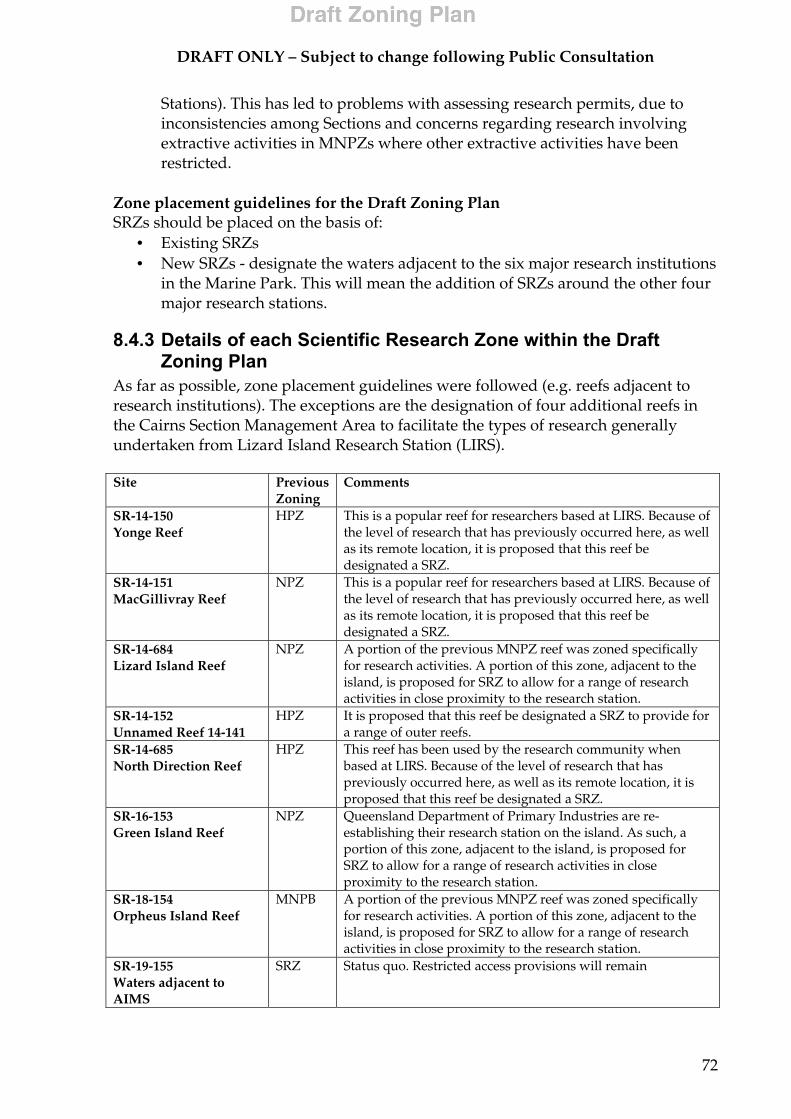
DRAFT ONLY – Subject to change following Public Consultation
72
Stations). This has led to problems with assessing research permits, due to inconsistencies among Sections and concerns regarding research involving extractive activities in MNPZs where other extractive activities have been restricted.
Zone placement guidelines for the Draft Zoning Plan SRZs should be placed on the basis of:
• Existing SRZs • New SRZs - designate the waters adjacent to the six major research institutions
in the Marine Park. This will mean the addition of SRZs around the other four major research stations.
8.4.3 Details of each Scientific Research Zone within the Draft Zoning Plan
As far as possible, zone placement guidelines were followed (e.g. reefs adjacent to research institutions). The exceptions are the designation of four additional reefs in the Cairns Section Management Area to facilitate the types of research generally undertaken from Lizard Island Research Station (LIRS). Site Previous
Zoning Comments
SR-14-150 Yonge Reef
HPZ
This is a popular reef for researchers based at LIRS. Because of the level of research that has previously occurred here, as well as its remote location, it is proposed that this reef be designated a SRZ.
SR-14-151 MacGillivray Reef
NPZ
This is a popular reef for researchers based at LIRS. Because of the level of research that has previously occurred here, as well as its remote location, it is proposed that this reef be designated a SRZ.
SR-14-684 Lizard Island Reef
NPZ
A portion of the previous MNPZ reef was zoned specifically for research activities. A portion of this zone, adjacent to the island, is proposed for SRZ to allow for a range of research activities in close proximity to the research station.
SR-14-152 Unnamed Reef 14-141
HPZ
It is proposed that this reef be designated a SRZ to provide for a range of outer reefs.
SR-14-685 North Direction Reef
HPZ
This reef has been used by the research community when based at LIRS. Because of the level of research that has previously occurred here, as well as its remote location, it is proposed that this reef be designated a SRZ.
SR-16-153 Green Island Reef
NPZ
Queensland Department of Primary Industries are re-establishing their research station on the island. As such, a portion of this zone, adjacent to the island, is proposed for SRZ to allow for a range of research activities in close proximity to the research station.
SR-18-154 Orpheus Island Reef
MNPB
A portion of the previous MNPZ reef was zoned specifically for research activities. A portion of this zone, adjacent to the island, is proposed for SRZ to allow for a range of research activities in close proximity to the research station.
SR-19-155 Waters adjacent to AIMS
SRZ
Status quo. Restricted access provisions will remain
DRAFT ONLY – Subject to change following Public Consultation
73
Site Previous Zoning
Comments
SR-23-156 Heron Island Reef
MNPA
A portion of the previous CPZ reef was zoned specifically for research activities. A portion of this zone, adjacent to the island, is proposed for SRZ to allow for a range of research activities in close proximity to the research station.
SR-23-157 One Tree Island Reef
SRZ
Status quo. Restricted access provisions will remain
8.5 Conservation Park Zone
8.5.1 Objectives CPZ provides for appreciation, recreational and other limited uses including limited line fishing. Fishing (including trolling) is restricted to one hand-held line per person with no more than one hook, lure or fly per line. Limited spearfishing and limited collecting is also allowed in the zone. Detailed information about changes to zoning provisions for recreational and commercial fishing activities allowed in the CPZ are detailed in Sections 7.1 (Recreational fishing activities) and 7.2 (Commercial fishing activities). Table 12: Change in the total area of CPZ for the Draft Zoning Plan.
Section of Marine Park Zoning Plan Previous Conservation Parks Zone in sq kms (%)
Reef-wide Draft Zoning Plan Conservation Park Zone in sq kms (%)
Far Northern Management Area
FNSZP 2002 1140 (1%) 680 (<1%)
Cairns/Cooktown Management Area
Cairns Section ZP 1992
153 (<1%) 945 (3%)
Townsville/Whitsundays Management Area
Central Section ZP 1987
665 (<1%) 1599 (2%)
Mackay/Capricorn Management Area
Mac/Cap Section ZP 1987 GWSZP 2002
95 (<1%)
9 (2.6%)
1657 (1%)
53 (15%)
8.5.2 Placement of the Conservation Park Zone Zone placement in previous Zoning Plans A variety of different reasons have been used to determine placement of the CPZ in previous Zoning Plans. These main purposes included:
• the general protection of biological values, where MNPZs would not necessarily provide any significant additional protection;
• the general protection of biological values, where the area had significant recreational values/uses (e.g. recreational fishing) which the GBRMPA did not want to limit or remove by including the area the MNPZ; and/or
• the separation of conflicting user groups. For example, separating high tourism usage (in waters surrounding as pontoons and resorts) from fishing activities including crabbing, netting, spearfishing and collecting. These activities were either limited or not allowed in the CPZ.
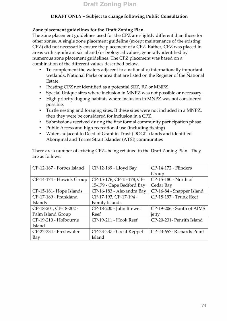
DRAFT ONLY – Subject to change following Public Consultation
74
Zone placement guidelines for the Draft Zoning Plan The zone placement guidelines used for the CPZ are slightly different than those for other zones. A single zone placement guideline (except maintenance of the existing CPZ) did not necessarily ensure the placement of a CPZ. Rather, CPZ was placed in areas with significant social and/or biological values, generally identified by numerous zone placement guidelines. The CPZ placement was based on a combination of the different values described below.
• To complement the waters adjacent to a nationally/internationally important wetlands, National Parks or area that are listed on the Register of the National Estate.
• Existing CPZ not identified as a potential SRZ, BZ or MNPZ. • Special Unique sites where inclusion in MNPZ was not possible or necessary. • High priority dugong habitats where inclusion in MNPZ was not considered
possible. • Turtle nesting and foraging sites. If these sites were not included in a MNPZ,
then they were be considered for inclusion in a CPZ. • Submissions received during the first formal community participation phase • Public Access and high recreational use (including fishing) • Waters adjacent to Deed of Grant in Trust (DOGIT) lands and identified
Aboriginal and Torres Strait Islander (ATSI) communities There are a number of existing CPZs being retained in the Draft Zoning Plan. They are as follows: CP-12-167 - Forbes Island CP-12-169 - Lloyd Bay CP-14-172 - Flinders
Group CP-14-174 - Howick Group CP-15-176, CP-15-178, CP-
15-179 - Cape Bedford Bay CP-15-180 - North of Cedar Bay
CP-15-181- Hope Islands CP-16-183 - Alexandra Bay CP-16-84 - Snapper Island CP-17-189 - Frankland Islands
CP-17-193, CP-17-194 - Family Islands
CP-18-197 - Trunk Reef
CP-18-201, CP-18-202 - Palm Island Group
CP-18-200 - John Brewer Reef
CP-19-206 - South of AIMS jetty
CP-19-210 - Holbourne Island
CP-19-211 - Hook Reef CP-20-231- Penrith Island
CP-22-234 - Freshwater Bay
CP-23-237 - Great Keppel Island
CP-23-657- Richards Point

DR
AFT
ON
LY
– S
ub
ject
to c
han
ge f
ollo
win
g P
ub
lic
Con
sult
atio
n
75
8.5.
3 D
etai
ls o
f eac
h C
onse
rvat
ion
Park
Zon
e w
ithin
the
Dra
ft Zo
ning
Pla
n S
ite
P
revi
ous
Zon
ing
Com
men
ts
CP
-11-
165
Cap
tain
Bil
ly L
and
ing
Unz
oned
Ref
er S
ecti
on 8
.9.2
(Hea
thla
nds
Sect
ion)
CP
-11-
166
Mar
gare
t Bay
U
nzon
ed
Ref
er S
ecti
on 8
.9.3
(Mar
gare
t Bay
Sec
tion)
CP
-12-
168
Fair
Cap
e U
nzon
ed
Ref
er S
ecti
on 8
.9.5
(Fai
r C
ape
Sect
ion)
CP
-13-
170
Bob
ard
t Poi
nt/
Nig
ht
Isla
nd
Unz
oned
R
efer
Sec
tion
8.9
.7 (N
ight
Isla
nd S
ecti
on)
CP
-14-
171
Por
t Ste
war
t U
nzon
ed
Ref
er S
ecti
on 8
.9.8
(Cla
rem
ont S
ecti
on)
CP
-14-
172
Flin
der
s G
rou
p/
Bat
hu
rst B
ay
Unz
oned
C
PZ
Exi
stin
g an
d r
efer
Sec
tion
8.9
.9 (B
athu
rst H
ead
Sect
ion)
CP
-14-
173
Nin
ian
Bay
U
nzon
ed
Ref
er S
ecti
on 8
.9.1
0 (N
inia
n B
ay S
ecti
on)
CP
-14-
175
Off
shor
e L
izar
d I
slan
d
R C
F
HPZ
G
UZ
Thi
s C
PZ is
impo
rtan
t for
rec
reat
iona
l fis
hing
for
visi
tors
and
tour
ists
on
Liza
rd Is
land
. Is
used
by
char
ter
fish
ers
on
the
way
out
to th
e R
ibbo
n R
eefs
.
CP
-15-
176
Bed
ford
Bay
C
P-1
5-17
8 E
nd
eavo
ur
Riv
er m
outh
C
P-1
5-17
9 W
alk
er B
ay
Unz
oned
C
PZ
Exi
stin
g an
d r
efer
Sec
tion
8.9
.12
(Coo
ktow
n Se
ctio
n)
CP
-15-
177
Egr
et/ B
ould
er R
eefs
, of
fsh
ore
Coo
kto
wn
R
GU
Z
HPZ
The
se r
eefs
hav
e be
en h
ighl
ight
ed a
s im
port
ant a
reas
for
recr
eati
onal
fish
ing
from
Coo
ktow
n.
CP
-15-
182
Pic
ker
sgil
l Ree
f O
ffsh
ore
Blo
omfi
eld
R
CF
HPZ
Thi
s re
ef is
a p
opul
ar a
ncho
rage
and
an
impo
rtan
t rec
reat
iona
l fis
hing
loca
tion
. A s
imila
r si
tuat
ion
exis
ts fo
r E
gret
an
d B
ould
er R
eefs
(CA
1844
) off
shor
e C
ookt
own.
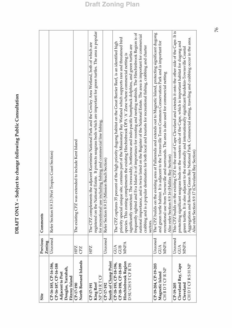
DR
AFT
ON
LY
– S
ub
ject
to c
han
ge f
ollo
win
g P
ub
lic
Con
sult
atio
n
76
Sit
e
Pre
viou
s Z
onin
g C
omm
ents
CP
-16-
185,
CP
-16-
186,
C
P-1
6-18
7, C
P-1
6-18
8 A
dja
cen
t to
Por
t D
ougl
as, Y
arra
bah
, Fi
tzro
y Is
lan
d
Unz
oned
R
efer
Sec
tion
8.9
.13
(Wet
Tro
pics
Coa
st S
ecti
on)
CP
-17-
190
Nor
th B
arn
ard
Isl
and
s H
PZ
CPZ
The
exi
stin
g C
PZ w
as e
xten
ded
to in
clud
e K
ent I
slan
d
CP
-17-
191
Kin
g R
eef
NP
CH
R T
CF
HPZ
T
he C
PZ c
ompl
emen
ts th
e ad
jace
nt K
urri
min
e N
atio
nal P
ark
and
the
Cow
ley
Are
a W
etla
nd, b
oth
of w
hich
are
re
gist
ered
on
the
Nat
iona
l Est
ate.
It p
rote
cts
seag
rass
bed
s w
hich
are
impo
rtan
t for
gre
en tu
rtle
s. T
he a
rea
is p
opul
ar
for
recr
eati
onal
use
incl
udin
g fi
shin
g an
d c
omm
erci
al li
ne fi
shin
g.
CP
-17-
192
Sou
th o
f C
lum
p P
oin
t U
nzon
ed
Ref
er S
ecti
on 8
.9.1
5 (M
issi
on B
each
Sec
tion)
CP
-18-
195,
CP
-18-
196,
C
P-1
8-19
8, C
P-1
8-19
9 H
inch
inb
rook
Reg
ion
D
SU
CH
S T
CF
R T
S
GU
A
GU
B
MN
PA
The
CPZ
cap
ture
s 35
per
cent
of t
he h
igh
prio
rity
dug
ong
habi
tat o
n th
e G
reat
Bar
rier
Ree
f , is
an
iden
tifi
ed h
igh
prio
rity
spe
cial
uni
que
site
, con
tain
s pa
rt o
f the
Mis
sion
ary
Bay
Wet
land
whi
ch s
uppo
rts
rare
and
thre
aten
ed b
ird
spec
ies.
Thi
s zo
ning
com
plem
ents
the
exis
ting
Hin
chin
broo
k D
PA ‘A
’ Zon
e w
here
com
mer
cial
net
ting
is
sign
ific
antl
y re
stri
cted
. The
irra
wad
dy,
bot
tlen
ose
and
ind
o-pa
cifi
c hu
mpb
ack
dol
phin
s, a
nd g
reen
turt
les
are
freq
uent
ly s
ight
ed a
nd E
va Is
land
is o
f im
port
ance
for
roos
ting
and
nes
ting
sea
bird
s. T
he H
inch
inbr
ook
Reg
ion
is o
f na
tion
al im
port
ance
, and
is tw
ice
liste
d on
the
Reg
iste
r of
the
Nat
iona
l Est
ate.
The
are
a is
impo
rtan
t for
com
mer
cial
cr
abbi
ng a
nd is
a p
opul
ar d
esti
nati
on fo
r bo
th lo
cal a
nd to
uris
ts fo
r re
crea
tion
al fi
shin
g, c
rabb
ing
and
cha
rter
se
ctor
s.
CP
-19-
204,
CP
-19-
203
Mag
net
ic I
slan
d
CH
B D
T C
F R
NP
Unz
oned
G
UA
M
NPA
The
CPZ
bui
lds
on th
e ex
isti
ng a
rea
at P
alla
rend
a an
d ex
tend
s ou
t to
Mag
neti
c Is
land
, pro
tect
ing
sign
ific
ant d
ugon
g an
d gr
een
turt
le h
abit
at. I
t is
adja
cent
to th
e T
owns
ville
Tow
n C
omm
on C
onse
rvat
ion
Park
and
is im
port
ant f
or
recr
eati
onal
use
from
Tow
nsvi
lle a
nd s
urro
und
s. T
he a
rea
is a
lso
used
for
com
mer
cial
net
ting
A
lso
refe
r Se
ctio
n 8.
9.16
(Hal
ifax
Bay
Sec
tion
) C
P-1
9-20
5 C
leve
lan
d B
ay, C
ape
Cle
vela
nd
C
H D
T C
F R
S H
NP
Unz
oned
G
UA
M
NPA
Thi
s C
PZ b
uild
s on
the
exis
tin g
CPZ
to th
e ea
st o
f Cap
e C
leve
land
and
ext
ends
it o
nto
the
othe
r si
de
of th
e C
ape.
It is
pr
otec
ting
sig
nifi
cant
sea
gras
s be
ds
on th
e w
este
rn s
ide
of th
e C
ape,
whi
ch is
impo
rtan
t hab
itat
for
dugo
ng a
nd
gree
n tu
rtle
s. It
is a
lso
adja
cent
to th
e na
tion
ally
and
inte
rnat
iona
lly s
igni
fica
nt B
urd
ekin
-Tow
nsvi
lle C
oast
al
Agg
rega
tion
and
Bow
ling
Gre
en B
ay N
atio
nal P
ark.
Com
mer
cial
net
ting
, tra
wlin
g an
d c
rabb
ing
occu
r in
the
area
. A
lso
refe
r Se
ctio
n 8.
9.17
(Cle
vela
nd B
ay S
ecti
on)

DR
AFT
ON
LY
– S
ub
ject
to c
han
ge f
ollo
win
g P
ub
lic
Con
sult
atio
n
77
Sit
e
Pre
viou
s Z
onin
g C
omm
ents
CP
-19-
207
Cap
e B
owli
ng
Gre
en
CH
B D
S N
P T
CF
GU
A
MN
PA
Thi
s C
PZ b
uild
s on
the
exis
ting
CPZ
on
the
east
of C
ape
Bow
ling
Gre
en a
nd e
xten
ds
it o
nto
the
othe
r si
de
of th
e C
ape.
It is
pro
vidi
ng a
dditi
onal
pro
tect
ion
for
the
Burd
ekin
-Tow
nsvi
lle C
oast
al A
ggre
gati
on, a
wet
land
of n
atio
nal
and
inte
rnat
iona
l sig
nifi
canc
e. T
he a
rea
is a
lso
impo
rtan
t for
dug
ong,
logg
erhe
ad a
nd g
reen
turt
les.
The
CPZ
m
aint
ains
acc
ess
to th
e co
ast a
nd th
e Bo
wlin
g G
reen
Bay
Nat
iona
l Par
k, w
hich
is im
port
ant f
or c
ampi
ng a
nd b
each
fi
shin
g. T
he a
rea
is im
port
ant t
o re
crea
tion
al u
sers
of T
owns
ville
and
sur
roun
ds.
CP
-19-
208
Old
Ree
f R
CF
A
GU
B O
ld R
eef i
s th
e cl
oses
t ree
f to
Ayr
and
Hom
e H
ill a
nd is
a p
opul
ar d
esti
nati
on fo
r re
crea
tion
al fi
sher
s fr
om th
ese
tow
ns. I
t is
also
use
d fo
r co
mm
erci
al li
ne fi
shin
g an
d tr
ochu
s co
llect
ion.
CP
-19-
209
Cap
e U
pst
art
GU
A
MN
PA
Exis
ting
wit
h sm
all e
xten
sion
CP
-19-
212;
CP
-20-
213
to
CP
-20-
216;
CP
-20-
218
to
CP
-20-
223.
W
hit
sun
day
Gro
up
N
P R
TS
GU
B
MN
PA
Exi
stin
g w
ith
exte
nsio
ns a
roun
d S
haw
and
Lin
dem
an Is
land
s, e
ast o
f Has
lew
ood
Isla
nd a
nd in
Mac
ona
Inle
t. T
he
addi
tion
s to
the
CPZ
com
plim
ents
the
high
rec
reat
iona
l use
in th
e W
hits
und
ay a
rea
and
the
man
y is
land
nat
iona
l pa
rks.
CP
-20-
219
Pio
nee
r B
ay
Unz
oned
R
efer
Sec
tion
8.9
.20
(Air
lie S
ecti
on)
CP
-20-
224
Rep
uls
e B
ay
GU
A
Unz
oned
R
efer
Sec
tion
8.9
.21
(Rep
ulse
Bay
Sec
tion
)
CP
-20-
225,
MN
P-2
0-11
3 S
ir J
ames
Sm
ith
Gro
up
N
P R
GU
B
The
are
a is
pop
ular
for
cam
ping
and
rec
reat
iona
l use
from
Sea
fort
h an
d M
acka
y. T
he C
PZ c
ompl
emen
ts th
e Ja
mes
Is
land
s N
atio
nal P
ark.
CP
-20-
227
Bra
mp
ton
Isl
and
N
P TS
R
GU
A
GU
B
MN
PA
Thi
s ex
tend
s on
the
exis
ting
MN
PA a
nd in
corp
orat
es th
e re
st o
f Bra
mpt
on a
nd C
arlis
le Is
land
s. It
com
plem
ents
the
Bra
mpt
on Is
land
s N
atio
nal P
ark.
The
are
a is
use
d r
ecre
atio
nally
and
ther
e is
a r
esor
t on
Bra
mpt
on Is
land
.
CP
-20-
228
Sea
fort
h a
nd
the
New
ry I
slan
ds
D T
S N
P C
F
GU
A
GU
B
Thi
s ar
ea c
onta
ins
80%
of a
hig
h pr
iori
ty d
ugon
g ha
bita
t, Fl
atba
ck T
urtl
e ne
stin
g si
tes
and
the
St H
elen
s Ba
y W
etla
nd, w
hich
ext
end
s in
to th
e C
PZ a
nd is
rec
ogni
sed
as
nati
onal
ly im
port
ant f
or s
hore
bird
s an
d s
uppo
rts
popu
lati
ons
of th
e en
dang
ered
Lit
tle
Ter
n. It
als
o co
ntai
ns th
e na
tion
ally
sig
nifi
cant
New
ry Is
land
Nat
iona
l Par
k.
Thi
s zo
ning
com
plem
ents
the
exis
ting
New
ry D
PA ‘A
’ Zon
e w
here
com
mer
cial
net
ting
is s
igni
fica
ntly
res
tric
ted
.
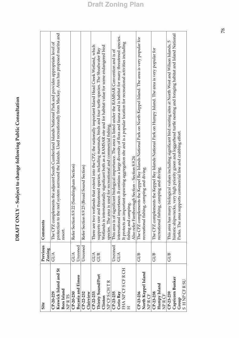
DR
AFT
ON
LY
– S
ub
ject
to c
han
ge f
ollo
win
g P
ub
lic
Con
sult
atio
n
78
Sit
e
Pre
viou
s Z
onin
g C
omm
ents
CP
-20-
229
Kes
wic
k I
slan
d a
nd
St
Bee
s Is
lan
d
NP
R T
S
GU
A
The
CPZ
com
plem
ents
the
adja
cent
Sou
th C
umbe
rlan
d Is
land
s N
atio
nal P
ark
and
prov
ides
app
ropr
iate
leve
l of
prot
ecti
on to
the
reef
sys
tem
sur
roun
d th
e Is
land
s. U
sed
rec
reat
iona
lly fr
om M
acka
y. A
rea
has
prop
osed
mar
ina
and
reso
rt.
CP
-20-
230
Bu
casi
a an
d E
imeo
G
UA
U
nzon
ed
Ref
er S
ecti
on 8
.9.2
2 (S
and
ring
ham
Sec
tion
)
CP
-22-
232
Cla
irvi
ew
Unz
oned
R
efer
Sec
tion
8.9
.23
(Bro
ad S
ound
Sec
tion
)
CP
-22-
233
Th
irst
y S
oun
d/P
ort
Cli
nto
n
NP
CF
S C
H T
R
GU
A
GU
B
The
re a
re tw
o w
etla
nds
that
ext
end
into
the
CPZ
; the
nat
iona
lly im
port
ant I
slan
d H
ead
Cre
ek W
etla
nd, w
hich
su
ppor
ts r
are
and
thre
aten
ed s
peci
es, i
nclu
ding
mam
mal
s, b
ird
s an
d fo
ur tu
rtle
spe
cies
. The
Sho
alw
ater
Bay
W
etla
nds
is in
tern
atio
nally
sig
nifi
cant
bot
h as
a R
AM
SAR
sit
e an
d fo
r ha
bita
t val
ue fo
r so
me
enda
nger
ed b
ird
sp
ecie
s. T
he a
rea
is u
sed
for
recr
eati
onal
and
com
mer
cial
fish
ing.
C
P-2
3-23
5 C
orio
Bay
FH
A N
P C
F S
CF
R C
H
H
Unz
oned
G
UA
Thi
s ar
ea is
of s
igni
fica
nt b
iolo
gica
l im
port
ance
. The
are
a is
list
ed u
nder
the
RA
MSA
R C
onve
ntio
n an
d is
of
inte
rnat
iona
l im
port
ance
. It c
onta
ins
a la
rge
dive
rsit
y of
flor
a an
d fa
una
and
is h
abit
at fo
r m
any
thre
aten
ed s
peci
es.
It p
rote
cts
an im
port
ant s
paw
ning
agg
rega
tion
sit
e an
d is
a p
opul
ar lo
cati
on fo
r re
crea
tion
al a
ctiv
itie
s in
clud
ing
fish
ing
and
cam
ping
. A
lso
refe
r Fa
rnbo
roug
h Se
ctio
n –
Sect
ion
8.9.
24
CP
-23-
236
Nor
th K
epp
el I
slan
d
NP
R C
F
GU
B
The
CPZ
com
plem
ents
the
Kep
pel B
ay Is
land
s N
atio
nal P
ark
on N
orth
Kep
pel I
slan
d. T
he a
rea
is v
ery
popu
lar
for
recr
eati
onal
fish
ing,
cam
ping
and
div
ing.
CP
-23-
238
Hu
mp
y Is
lan
d
NP
R C
F
GU
B
The
CPZ
com
plem
ents
the
Kep
pel B
ay Is
land
s N
atio
nal P
ark
on H
umpy
Isla
nd. T
he a
rea
is v
ery
popu
lar
for
recr
eati
onal
fish
ing,
cam
ping
and
div
ing.
CP
-23-
239
Cap
rico
rn B
un
ker
G
rou
p
S H
NP
CF
R S
U
GU
B
Thi
s ar
ea h
as m
any
biol
ogic
al v
alue
s in
clud
ing
sign
ific
ant b
ird
nest
ing
site
s at
Nor
th W
est a
nd W
ilson
Isla
nds,
5
hist
oric
shi
pwre
cks,
ver
y hi
gh p
rior
ity
gree
n an
d lo
gger
head
turt
le n
esti
ng a
nd fo
ragi
ng h
abit
at a
nd Is
land
Nat
iona
l Pa
rks.
The
are
a su
ppor
ts c
omm
erci
al li
ne a
nd c
rabb
ing
effo
rt.
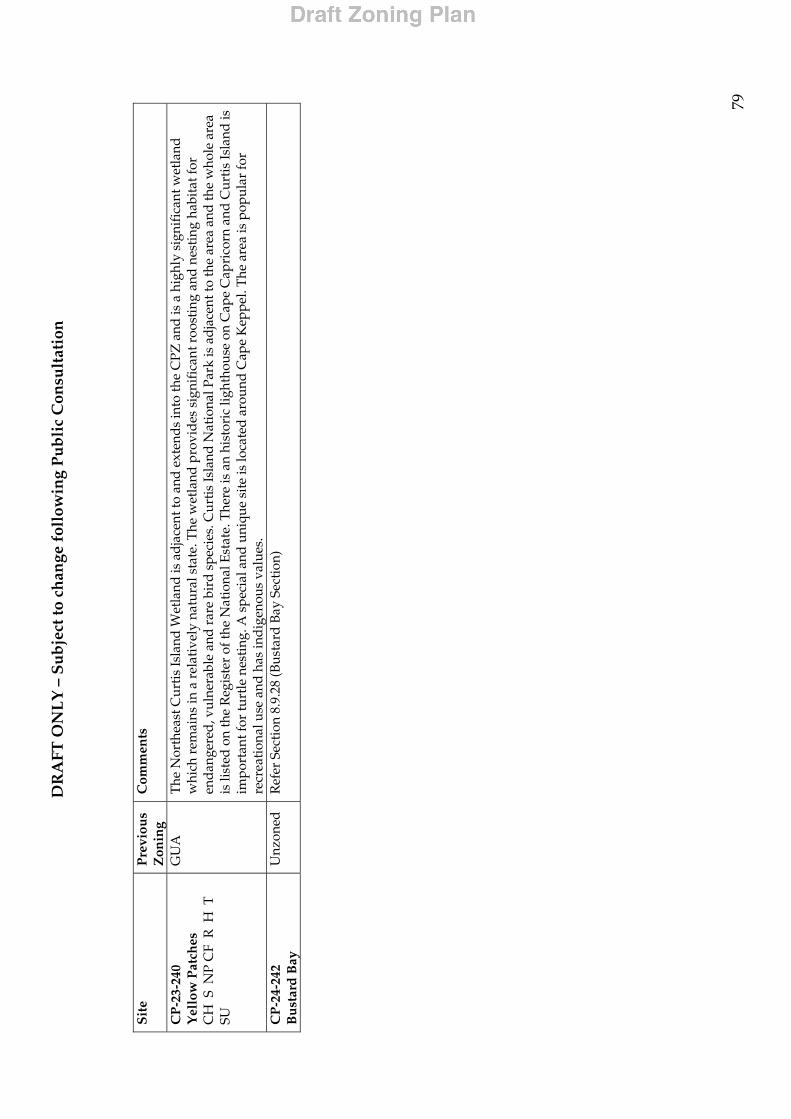
DR
AFT
ON
LY
– S
ub
ject
to c
han
ge f
ollo
win
g P
ub
lic
Con
sult
atio
n
79
Sit
e
Pre
viou
s Z
onin
g C
omm
ents
CP
-23-
240
Yel
low
Pat
ches
C
H S
NP
CF
R H
T
SU
GU
A
The
Nor
thea
st C
urti
s Is
land
Wet
land
is a
dja
cent
to a
nd e
xten
ds
into
the
CPZ
and
is a
hig
hly
sign
ific
ant w
etla
nd
whi
ch r
emai
ns in
a r
elat
ivel
y na
tura
l sta
te. T
he w
etla
nd p
rovi
des
sig
nifi
cant
roo
stin
g an
d n
esti
ng h
abit
at fo
r en
dan
gere
d, v
ulne
rabl
e an
d r
are
bird
spe
cies
. Cur
tis Is
land
Nat
iona
l Par
k is
ad
jace
nt to
the
area
and
the
who
le a
rea
is li
sted
on
the
Reg
iste
r of
the
Nat
iona
l Est
ate.
The
re is
an
hist
oric
ligh
thou
se o
n C
ape
Cap
rico
rn a
nd C
urti
s Is
land
is
impo
rtan
t for
turt
le n
esti
ng. A
spe
cial
and
uni
que
site
is lo
cate
d a
roun
d C
ape
Kep
pel.
The
are
a is
pop
ular
for
recr
eati
onal
use
and
has
ind
igen
ous
valu
es.
CP
-24-
242
Bu
star
d B
ay
Unz
oned
R
efer
Sec
tion
8.9
.28
(Bus
tard
Bay
Sec
tion
)
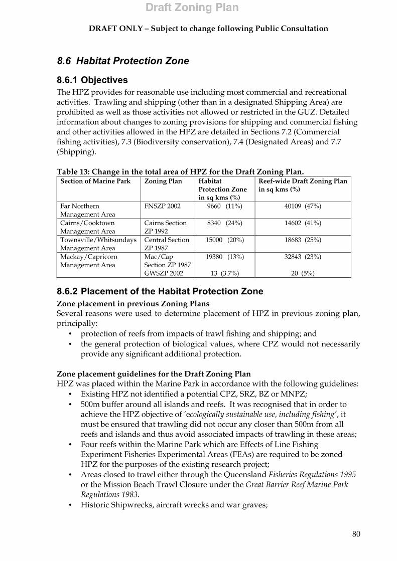
DRAFT ONLY – Subject to change following Public Consultation
80
8.6 Habitat Protection Zone
8.6.1 Objectives The HPZ provides for reasonable use including most commercial and recreational activities. Trawling and shipping (other than in a designated Shipping Area) are prohibited as well as those activities not allowed or restricted in the GUZ. Detailed information about changes to zoning provisions for shipping and commercial fishing and other activities allowed in the HPZ are detailed in Sections 7.2 (Commercial fishing activities), 7.3 (Biodiversity conservation), 7.4 (Designated Areas) and 7.7 (Shipping). Table 13: Change in the total area of HPZ for the Draft Zoning Plan.
Section of Marine Park Zoning Plan Habitat Protection Zone in sq kms (%)
Reef-wide Draft Zoning Plan in sq kms (%)
Far Northern Management Area
FNSZP 2002 9660 (11%) 40109 (47%)
Cairns/Cooktown Management Area
Cairns Section ZP 1992
8340 (24%) 14602 (41%)
Townsville/Whitsundays Management Area
Central Section ZP 1987
15000 (20%) 18683 (25%)
Mackay/Capricorn Management Area
Mac/Cap Section ZP 1987 GWSZP 2002
19380 (13%)
13 (3.7%)
32843 (23%)
20 (5%)
8.6.2 Placement of the Habitat Protection Zone Zone placement in previous Zoning Plans Several reasons were used to determine placement of HPZ in previous zoning plan, principally:
• protection of reefs from impacts of trawl fishing and shipping; and • the general protection of biological values, where CPZ would not necessarily
provide any significant additional protection. Zone placement guidelines for the Draft Zoning Plan HPZ was placed within the Marine Park in accordance with the following guidelines:
• Existing HPZ not identified a potential CPZ, SRZ, BZ or MNPZ; • 500m buffer around all islands and reefs. It was recognised that in order to
achieve the HPZ objective of ‘ecologically sustainable use, including fishing’, it must be ensured that trawling did not occur any closer than 500m from all reefs and islands and thus avoid associated impacts of trawling in these areas;
• Four reefs within the Marine Park which are Effects of Line Fishing Experiment Fisheries Experimental Areas (FEAs) are required to be zoned HPZ for the purposes of the existing research project;
• Areas closed to trawl either through the Queensland Fisheries Regulations 1995 or the Mission Beach Trawl Closure under the Great Barrier Reef Marine Park Regulations 1983.
• Historic Shipwrecks, aircraft wrecks and war graves;
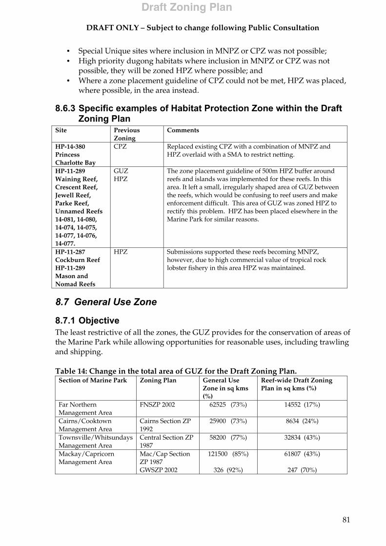
DRAFT ONLY – Subject to change following Public Consultation
81
• Special Unique sites where inclusion in MNPZ or CPZ was not possible; • High priority dugong habitats where inclusion in MNPZ or CPZ was not
possible, they will be zoned HPZ where possible; and • Where a zone placement guideline of CPZ could not be met, HPZ was placed,
where possible, in the area instead.
8.6.3 Specific examples of Habitat Protection Zone within the Draft Zoning Plan
Site Previous Zoning
Comments
HP-14-380 Princess Charlotte Bay
CPZ Replaced existing CPZ with a combination of MNPZ and HPZ overlaid with a SMA to restrict netting.
HP-11-289 Waining Reef, Crescent Reef, Jewell Reef, Parke Reef, Unnamed Reefs 14-081, 14-080, 14-074, 14-075, 14-077, 14-076, 14-077.
GUZ HPZ
The zone placement guideline of 500m HPZ buffer around reefs and islands was implemented for these reefs. In this area. It left a small, irregularly shaped area of GUZ between the reefs, which would be confusing to reef users and make enforcement difficult. This area of GUZ was zoned HPZ to rectify this problem. HPZ has been placed elsewhere in the Marine Park for similar reasons.
HP-11-287 Cockburn Reef HP-11-289 Mason and Nomad Reefs
HPZ
Submissions supported these reefs becoming MNPZ, however, due to high commercial value of tropical rock lobster fishery in this area HPZ was maintained.
8.7 General Use Zone
8.7.1 Objective The least restrictive of all the zones, the GUZ provides for the conservation of areas of the Marine Park while allowing opportunities for reasonable uses, including trawling and shipping. Table 14: Change in the total area of GUZ for the Draft Zoning Plan.
Section of Marine Park Zoning Plan General Use Zone in sq kms (%)
Reef-wide Draft Zoning Plan in sq kms (%)
Far Northern Management Area
FNSZP 2002 62525 (73%) 14552 (17%)
Cairns/Cooktown Management Area
Cairns Section ZP 1992
25900 (73%) 8634 (24%)
Townsville/Whitsundays Management Area
Central Section ZP 1987
58200 (77%) 32834 (43%)
Mackay/Capricorn Management Area
Mac/Cap Section ZP 1987 GWSZP 2002
121500 (85%)
326 (92%)
61807 (43%)
247 (70%)
DRAFT ONLY – Subject to change following Public Consultation
82
8.7.2 Placement of the General Use Zone Zone placement in previous Zoning Plans In previous Zoning Plans, the GUZ covered all areas of the Marine Park for which a higher level of protection was considered unnecessary. Zone placement guidelines for the Draft Zoning Plan The following guidelines were applied in the placement of GUZs:
• Where zone placement guidelines of all other zones are not met, the area will be GUZ;
• Areas important for trawling or shipping which are not within 500m of a reef or island, will be GUZ.
8.8 Commonwealth Islands Zone
8.8.1 Objectives This zone applies to all Commonwealth-owned islands or parts of islands. It provides for the conservation of those areas in a natural state, while allowing the public to appreciate and enjoy them. The zone provides for activities to be undertaken by the Commonwealth or under a lease from the Commonwealth. The zone also deals specifically with management of land-based activities, such as camping, roads and infrastructure.
8.8.2 Placement of the Commonwealth Island Zone Zone placement in previous Zoning Plans
• The Commonwealth Islands Zone was placed around Commonwealth owned islands in the Far Northern and Gumoo Woojabuddee Sections.
Zone placement guidelines for the Draft Zoning Plan The Commonwealth Islands Zone has been applied to Commonwealth Islands within the Marine Park. However, as detailed mapping of all Commonwealth Islands has not been undertaken, these zones are not depicted on the zoning maps.
8.8.3 Specific examples of Commonwealth Islands Zone within the Draft Zoning Plan
Commonwealth-owned islands and rocks within the Marine Park are zoned Commonwealth Islands Zone above the low water mark. The following islands or parts of these islands are proposed to be zoned Commonwealth Islands Zone in the Draft Zoning Plan. Far Northern Management Area
Albany Rock, East Hannibal Island, Clerke Island, Hannah Island, Pipon Island, Coquet Island, Cairncross Islet, Restoration Rock, South Barrow Islet
Cairns/Cooktown Management Area
Low Isles, Palfray Island, Rocky Islet, Little Fitzroy Island, Russell Island, Kent Island

DRAFT ONLY – Subject to change following Public Consultation
83
Townsville/Whitsunday Management Area
Dent Island, Southbrook Island, Bay Rock, Eshelby Island
Mackay/Capricorn Management Area
Entrance Island, Quoin Island, Double Rock, Single Rock, Black Rock, Round Island, Observation Rock, Ranken Island, Manifold Island, Lady Elliott Island, Flat Top Island, Townsend Island, Coppersmith Island, Penrith Island, Bailey Islet, Pine Islet, High Peak Island, North Reef Island
8.9 New Coastal Area Zoning As discussed in Section 2.3.4 (Zoning the new coastal sections of the Marine Park), accounts on the proposed zoning for the 28 new coastal sections of the Marine Park are detailed below. Appendix 10.3 (New coastal areas map) includes a map depicting these new coastal Sections. Comprehensive information on the cultural and human uses of each Section, gathered from extensive research and public submissions received during the first formal phase of public consultation, provides the basis for the zoning proposed. The GBRMPA is currently gathering information on Indigenous values relating to the Marine Park. This will be refined during the second formal phase of community participation. Due to the incomplete nature of information on Indigenous values of the Marine Park, these values are not listed below, however they are discussed if a proposed zone placement has been affected by these values. All closures to trawl refer to permanent closures as described in the Fisheries (East Coast Trawl) Management Plan 1999 unless stated otherwise.
8.9.1 Shadwell Section
8.9.1.1 Background The Sharp Point - Sadd Point coastal area extends 13.6 km along the coast and is characterised by sediments derived from Jurassic sandstones and Quaternary alluvials. The coastline is marked by sandstone outcrops and dune fields. Seagrass meadows occur in the inshore waters, providing foraging habitat for dugong and turtle populations. The Shadwell coast area is an integral part of the nationally important Newcastle Bay Wetlands, which are recognised as significant habitat for estuarine crocodiles.
8.9.1.2 Overview of attributes (refer to Section 8, Table 7 for symbols) Description Description CH Adjacent to Orford Bay-Sharp Point
Dunefield Aggregation (nationally significant wetland), which is significant habitat for estuarine crocodiles.
CF Trawl
P Barge landing. H Historic shipwreck – Esperanza, sunk 1903.
DRAFT ONLY – Subject to change following Public Consultation
84
Description Description B Inshore dry reef. Inshore seagrass
provides habitat for turtle and dugong.
S Major bird nesting sites at Tern Island and Thompson Island.
NP Shadwell Resources Reserve and Jardine River National Park
R Minimal recreational use due to remote location.
BI Non-reef bioregion NA1 and NB1. Reef bioregion RE1.
8.9.1.3 Summary of submissions • Submissions from commercial and recreational fishermen expressed a desire
to retain access to the area for fishing. It was stated that GUZ would be appropriate as the Section is important for mackerel trolling, especially around Tern Island;
• One submission stated that the Section should be HPZ out to the edge of the trawl closure and the rest should be GUZ as the coastal fringing reefs are used by the rock lobster fishery. This submission also stated that the bioregion encompassing this area is adequately protected;
• Another submission asked that the Section be GUZ to maintain access for the fishing industry as mother ships servicing the fishing fleet use this coastal area.
8.9.1.4 Zoning Proposed Zoning: HPZ and GUZ Reasoning for Proposed Zoning:
• Half of the Section will be zoned HPZ via a line from the HPZ adjacent to the Section along the coast. This will reflect the existing area closed to trawling under the Fisheries (East Coast Trawl) Management Plan 1999. This will also provide a buffer to the Orford Bay-Sharp Point Dunefield Aggregation and provide a level of protection for the inshore dry reef and seagrass;
• The remainder of the Section will be GUZ as commercial fishing is an important use of the Section and this will enable this activity to continue.
8.9.2 Heathlands Section
8.9.2.1 Background The Heathland Section extends 14.2 km and is characterised by Quaternary sands, forming extensive dune systems along the adjacent coast. These dunes are recognised as being of national significance. The Captain Billy Landing area is an integral part of the large Shelburne Bay region, which is a key coastal conservation area. The new coastal Section is adjoined on three sides by the existing large MNPZ known as the Cross-shelf Transect.
DRAFT ONLY – Subject to change following Public Consultation
85
8.9.2.2 Overview of attributes (refer to Section 8, Table 7 for symbols)
8.9.2.3 Summary of submissions • Submissions on this Section mainly supported MNPZ and CPZ; • Submissions noted that since the introduction of the MNPZ cross-shelf
transect, this Section had become isolated and difficult to work for the rock lobster fishery. Zone as MNPZ;
• Another submission from a rock lobster fisherman also suggested MNPZ for the area as it provided an area of refuge for breeding rock lobster and is also an important seagrass area;
• Submissions noted the importance of Captain Billy Landing as an area for recreational fishing because it has vehicle access. Zone as CPZ as this will assist in promoting the area as a tourist destination;
• Another submission asked that the Section be GUZ to maintain access for the fishing industry as mother ships servicing the fishing fleet use this Section.
8.9.2.4 Zoning Proposed Zoning: MNPZ and CPZ Reasoning for Proposed Zoning:
• CPZ along the coast will allow residents of Captain Billy Landing and tourists to maintain current fishing access. The rest of the Section is MNPZ to protect the extensive natural values of the Section and join with the surrounding MNPZ.
8.9.3 Margaret Bay Section
8.9.3.1 Background The Margaret Bay Section extends 14.8km along the coast to the north of Cape Grenville, and includes Sunday Island and a number of shoals. The area is characterised by Quaternary sands, forming dune systems along the adjacent coast. These dunes are recognised as being of national significance. The Margaret Bay area is an integral part of the large Shelburne Bay region, which is a key coastal conservation area. The whole area is of high to very high wilderness quality.
Description Description CH Extensive dune systems along the
adjacent coast is recognised as being of national significance.
CF Trawl
T Present. R Coastal access provides for recreational fishing use.
D Present. H Historic air wreck. B Large inshore seagrass beds. Large
coastal fringing reef systems. P Minor coastal access point.
A Small community at Captain Billy Landing.
NP Heathlands Resource Reserve and the Jardine River National Park
BI Non-reef bioregion NA1 and NB1. Reef bioregion RE1.
DRAFT ONLY – Subject to change following Public Consultation
86
8.9.3.2 Overview of attributes (refer to Section 8, Table 7 for symbols) Description Description D Part of the important dugong
habitat of Shelburne Bay. Identified as significant.
CF Trawl Tropical Rock Lobster
B Extensive inshore seagrass beds marked as outstanding for their size and diversity. Bremner Shoal and coastal reef off Sunday Island.
P Area accessible by road. Proposed Port Area by Queensland State Government. Important for airfreight of tropical rock lobster from nearby reefs.
CH Nationally significant quaternary sands, forming dune systems along the adjacent coast. Nationally significant Shelburne Bay wetlands. Mangroves along Cape Grenville.
R Recreational camping and fishing area due to vehicular access.
P Anchorage for the crayfish fleet. S Sunday Island is a minor bird breeding site. H Two historic WW2 airwrecks. T Hawksbill and green turtles present in this area BI Non-reef bioregion NA1 and NB1.
Reef bioregion RE1.
8.9.3.3 Summary of submissions • Submissions noted that this area is a very important south-east anchorage for
mother ships. Zone GUZ; • It was also raised in submissions that the Section is an important rock lobster
area, in particular inshore fringing reefs. It is also an important crayfish off-loading point for shipment to Cairns. Zone HPZ.
• Conversely, concern was expressed about over harvesting of crayfish and the use of the Section beach as an offloading point for crayfish;
• Submissions stated that the bioregions are adequately protected in this area; • Recreational users stated that the Section provides quality camping and
fishing in south east trade winds; • There was support to protect the Section against mesh netting and crayfishing.
Zone CPZ; • Fishing industry submissions asked for the Section to be GUZ to maintain
access to the coastal area.
8.9.3.4 Zoning Proposed Zoning: CPZ, HPZ and GUZ Reasoning for Proposed Zoning:
• The majority of the Section will be CPZ within the existing area closed to trawling under the Fisheries (East Coast Trawl) Management Plan 1999. CPZ will be extended to encompass Bremner Shoal and to join existing HPZ outside the Section around islands off Cape Grenville. CPZ will provide protection for the extensive natural values of the Section such as dugong habitat, significant seagrass beds and provide a buffer to the dune systems and wetlands along the coast. It will also restrict or prevent crayfishing;
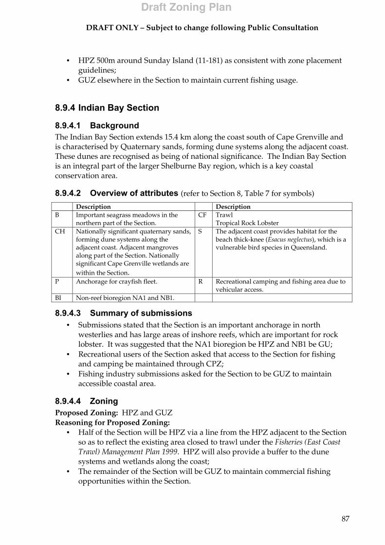
DRAFT ONLY – Subject to change following Public Consultation
87
• HPZ 500m around Sunday Island (11-181) as consistent with zone placement
guidelines; • GUZ elsewhere in the Section to maintain current fishing usage.
8.9.4 Indian Bay Section
8.9.4.1 Background The Indian Bay Section extends 15.4 km along the coast south of Cape Grenville and is characterised by Quaternary sands, forming dune systems along the adjacent coast. These dunes are recognised as being of national significance. The Indian Bay Section is an integral part of the larger Shelburne Bay region, which is a key coastal conservation area.
8.9.4.2 Overview of attributes (refer to Section 8, Table 7 for symbols)
8.9.4.3 Summary of submissions • Submissions stated that the Section is an important anchorage in north
westerlies and has large areas of inshore reefs, which are important for rock lobster. It was suggested that the NA1 bioregion be HPZ and NB1 be GU;
• Recreational users of the Section asked that access to the Section for fishing and camping be maintained through CPZ;
• Fishing industry submissions asked for the Section to be GUZ to maintain accessible coastal area.
8.9.4.4 Zoning Proposed Zoning: HPZ and GUZ Reasoning for Proposed Zoning:
• Half of the Section will be HPZ via a line from the HPZ adjacent to the Section so as to reflect the existing area closed to trawl under the Fisheries (East Coast Trawl) Management Plan 1999. HPZ will also provide a buffer to the dune systems and wetlands along the coast;
• The remainder of the Section will be GUZ to maintain commercial fishing opportunities within the Section.
Description Description B Important seagrass meadows in the
northern part of the Section. CF Trawl
Tropical Rock Lobster CH Nationally significant quaternary sands,
forming dune systems along the adjacent coast. Adjacent mangroves along part of the Section. Nationally significant Cape Grenville wetlands are within the Section.
S The adjacent coast provides habitat for the beach thick-knee (Esacus neglectus), which is a vulnerable bird species in Queensland.
P Anchorage for crayfish fleet. R Recreational camping and fishing area due to vehicular access.
BI Non-reef bioregion NA1 and NB1.

DRAFT ONLY – Subject to change following Public Consultation
88
8.9.5 Fair Cape Section
8.9.5.1 Background The Mosquito Point-Fair Cape coastal area extends 18.4 km and is characterised by sediments derived from rhyolites and acid volcanics, and Jurassic sandstones. These fine sediments support extensive seagrass meadows. The area is part of the key conservation area of the Olive River Dunes and an important dugong foraging habitat. Extensive fringing reefs occur in this area and there are a number of extensive shoals. 8.9.5.2 Overview of attributes (refer to Section 8, Table 7 for symbols)
8.9.5.3 Summary of submissions • A commercial fishing submission stated that the fringing and deeper reefs of
the Section are used by the rock lobster fishery. As many areas to the north and south of the Section are already closed to fishing, HPZ was suggested;
• Submissions suggested CPZ or GUZ to enable line fishing to continue in the Section;
• Recreational fishing interests asked that the Section be zoned MNPZ; • Fishing industry submissions asked for the Section to be GUZ to maintain
accessible coastal area.
8.9.5.4 Zoning Proposed Zoning: MNPZ, CPZ and GUZ Reasoning for Proposed Zoning:
• MNPZ and CPZ will reflect the existing area closed to trawling under the Fisheries (East Coast Trawl) Management Plan 1999. MNPZ will cover the northern half of the Section’s trawl closure and CPZ the south portion. MNPZ will provide protection to important inner reefs, seagrass and dugong habitat and provide a buffer to mangroves adjacent to the Section.
• CPZ will provide a level of protection to Kangaroo Shoals and provide for recreational fishing to continue within the Section;
• The remainder of the Section will be GUZ to maintain commercial fishing opportunities within the Section.
Description Description B Extensive fringing reefs and a
number of shoals (Kangaroo Shoals and Andrew Reef). Extensive seagrass meadows.
CF Netting Trawl Tropical Rock Lobster
D Important dugong foraging habitat.
R Small amount of recreational fishing.
CH Part of the key conservation area of the Olive River Dunes. Mangroves adjacent to the Section.
A Community located at Pascoe River.
BI Non-reef bioregion NA1 and NB1. Reef bioregion RE1.

DRAFT ONLY – Subject to change following Public Consultation
89
8.9.6 Weymouth Section
8.9.6.1 Background The Cape Weymouth- Portland Roads coastal area is characterised by ranges of granites and strongly metamorphosed sandstones. The 16 km coastal area includes extensive fringing reef systems and abuts the Iron Range National Park, which is an area of high conservation significance. Other landforms within the Section include Restoration Island and Rocky Island.
8.9.6.2 Overview of attributes (refer to Section 8, Table 7 for symbols) Description Description NP Iron Range Resources Reserve and
Iron Range National Park. CF Trawl.
B Extensive fringing reef. R Recreational fishing use by surrounding communities.
A Portland Roads - small settlement & port facility
P Barge landing facility at Portland Roads. Popular fishing fleet anchorage.
TS Tourism resort on Restoration Island. BI Non-reef bioregion NA1 and NB1. Reef bioregion RE1.
8.9.6.3 Summary of submissions • A submission noted that the Section is used for crayfishing, however this has
become difficult in recent years due to crocodiles. Zone as GUZ; • Commercial fishing submissions stated that the Section is an important
anchorage for mother vessels and commercial fishing vessels. It was outlined that Spanish mackerel fishing and crabbing occur within the Section. GUZ was suggested to maintain accessible coastal area for the fishing industry;
• Submissions stated that Portland Road and Cape York residents use the Section for recreational fishing. Submissions asked for HPZ or CPZ;
• A submission asked that the Section be CPZ to enable commercial line fishing to continue;
• One submission suggested HPZ to eliminate trawling and allow seagrass, inter reef gardens and deep-water seagrass to regenerate where they have been damaged in the Section. It was declared that this would also create a corridor from the estuaries of the Pascoe, Claudie and Lockhart Rivers, with their extensive catchments to the Coral Sea;
• A submission stated the Section should be CPZ as it is a valuable tourist destination.

DRAFT ONLY – Subject to change following Public Consultation
90
8.9.6.4 Zoning Proposed Zoning: HPZ and GUZ Reasoning for Proposed Zoning:
• HPZ within the existing area closed to trawl under the Fisheries (East Coast Trawl) Management Plan 1999 and 500m HPZ buffer around Restoration Island and Restoration Rock Reef will provide a level of protection to fringing reef and provide a buffer to the adjacent National Park whilst allowing current fishing usage to continue;
• The remainder of the Section will be GUZ to maintain commercial fishing opportunities within the Section.
8.9.7 Night Island Section
8.9.7.1 Background The Bobardt Point - Night Island coastal area extends 10 km along the coast and is characterised by ranges of granites and strongly metamorphosed sandstones. The area is part of the McIlwraith-Lockhart area of conservation significance and includes extensive fringing reef systems and extensive inshore seagrass meadows that constitute important dugong habitat.
8.9.7.2 Overview of attributes (refer to Section 8, Table 7 for symbols) Description Description D French Point to Bobardt Point is
part of a significant dugong habitat. CF Trawl
Line fishing S The adjacent Night Island supports
the largest breeding population of Pied Imperial Pigeons in Australia.
A Lockhart River is the closest community to the Section.
CH Mangroves adjacent to the northern half the Section.
P Cruise Ship Anchorage at Night Island (outside the Section).
FHA Present. R Recreational fishing and camping occurs due to vehicular access.
B Extensive fringing reef systems. Extensive inshore seagrass meadows.
BI Non-reef bioregion NA1 and NB1. Reef bioregion RE1.
8.9.7.3 Summary of submissions • Some submissions stated that inshore and offshore areas of the Section are
important for the rock lobster fishery and should be HPZ. Night Island is an important anchorage for fishers and should remain CPZ to allow release of tenders from commercial vessels;
• A submission asked for CPZ in the Section to enable commercial line fishermen to continue to use this area;

DRAFT ONLY – Subject to change following Public Consultation
91
• One submission suggested the Section be CPZ to stop the heavy trawling which currently occurs;
• One submission noted that this is an important recreational fishing area and should not be MNPZ.
8.9.7.4 Zoning Proposed Zoning: CPZ with MNPZ around Night Island Reasoning for Proposed Zoning:
• CPZ for the entire Section will offer a suitable level of protection from potentially threatening activities to fringing reefs, seagrass beds and dugong whilst allowing line fishing and restricted crayfishing to continue;
• A 500m MNPZ zone around Night Island will protect this area of cultural significance and accommodate and complement Indigenous management of the Island.
8.9.8 Claremont Section
8.9.8.1 Background Claremont Section extends along 10.7km of coastline in the vicinity of Port Stewart. The coastal area is characterised by sediments derived from Tertiary and Jurassic sandstones, and alluvial sand plains of clays and silts. Low dunes and salt plains occur adjacent to the Section, and the seasonal Stewart River flows into the area. The area is part of the nationally significant wetlands of Princess Charlotte Bay. Inshore seagrass meadows and high numbers of dugong occur in the area and its surrounds.
8.9.8.2 Overview of attributes (refer to Section 8, Table 7 for symbols) Description Description D High numbers of dugong occur in the
area and its surrounds. Amongst the most important areas of dugong habitat in the northern Great Barrier Reef Region.
CF Net fishing Line fishing Trawl
B Inshore seagrass meadows. Coastal fringing reefs.
S The adjacent coast provides habitat for the little tern (Sterna albifrons sinensis), which is endangered in Queensland.
FHA Present. H Historic shipwreck – Stewart, sunk 1951. CH The Section is nationally significant
for the diversity of wetlands. Adjacent to two nationally important wetlands.
P Major access point for recreational users on Cape York
R Highly accessible area used for recreational fishing.
A Port Stewart
BI Non-reef bioregion NA1 and NB1. Reef bioregion RE1.

DRAFT ONLY – Subject to change following Public Consultation
92
8.9.8.3 Summary of submissions • Submissions stated that the Section is important to Aboriginal people for
recreational and subsistence fishing. The Lama Lama Traditional Owners have two outstations in the vicinity of Port Stewart;
• Submissions noted that the Lama Lama Traditional Owners and the local community are interested in promoting tourism in the area. One submission stated that the Section is a significant tourism and recreation area with conservation values and suggested CPZ;
• Submissions noted that commercial netting is seen as detrimental to tourism. There is significant concern with disposal of bycatch from netting as these species would otherwise be taken for tourism, recreation or indigenous consumption;
• A submission expressed concern that professional fisherman are overfishing the Section and asked for CPZ.
• A submission noted that the Section is a major recreational fishing access point and this access should be maintained. It was stated that the local community relies on Port Stewart for fishing;
• Submissions suggested GUZ as coastal areas are used for trawl, anchorage and transhipment/resupply from mother ships;
8.9.8.4 Zoning Proposed Zoning: CPZ Reasoning for Proposed Zoning:
• The entire Section will be CPZ to offer a suitable level of protection from potentially threatening activities to dugong habitat, coastal wetlands, fringing reefs and seagrass beds;
• CPZ accommodates the high recreational fishing and tourism use of the Section and addresses community concerns raised in submissions.
8.9.9 Bathurst Head Section
8.9.9.1 Background The Bathurst Head Section extends along 33.7km of coastline adjacent to Bathurst Bay, Princess Charlotte Bay and the Lakefield area of conservation significance. The area is characterised by headlands of Jurassic sandstone including Combe Point. The inshore waters support high-density seagrass meadows and high seagrass species diversity.
8.9.9.2 Overview of attributes (refer to Section 8, Table 7 for symbols) Description Description D Adjacent Princess Charlotte Bay
and Bathurst Bay area highly significant dugong habitat, supporting some of the highest densities of dugong in Queensland.
CF Netting Trawl Crabbing Charter

DRAFT ONLY – Subject to change following Public Consultation
93
Description Description B High density and diversity
seagrass. R High recreational fishing in the east due to
easy access. FHA Area adjacent to Combe Point &
Bathurst Bay. P One of a limited number of access points to
east coast of Cape York Peninsula. CH Tidal wetlands on the shores of
Princess Charlotte Bay & Bathurst Bay are nationally significant.
SU Adjacent Princess Charlotte Bay Marine Area and the Bathurst Bay – Flinders Islands Group.
NP Cape Melville and Lakefield National Parks.
BI Non-reef bioregions NA1, NB1 and NK.
8.9.9.3 Summary of submissions • There was support in submissions for the Section to be HPZ as there is
already extensive CPZ in the area and Bathurst Head is a good SE anchorage; • MNPZ zoning was not supported in the Section as it is popular for
recreational and commercial fishing, however access is seasonal; • One submission noted that coastal areas in this part of the Marine Park are
used for trawl, anchorage and transhipment/resupply from mother ships and should be GUZ;
• CPZ was supported in submissions as Bathurst Head is a popular fishing, camping and tourist destination with a sheltered anchorage and conservation values;
• Closing the Section to commercial netting was supported, as this is a threat to fish stocks.
8.9.9.4 Zoning Proposed Zoning: CPZ and GUZ Reasoning for Proposed Zoning:
• The Bathurst Bay CPZ will be extended south–westerly to Bathurst Head so as to include the extensive areas of seagrass and important dugong habitat within Bathurst Bay;
• Princess Charlotte Bay is proposed to be CPZ, with a SMA placed over the zone;
• It is proposed to extend the Princess Charlotte Bay CPZ via a line from the edge of the trawl closure to the SW-most point of Blackwood Island, and including Bathurst Head, so as to reflect the existing area closed to trawl under the Fisheries (East Coast Trawl) Management Plan 1999. This area will be included within the proposed Princess Charlotte Bay SMA;
• The remainder of the Section is to be GUZ to maintain commercial fishing opportunities within the Section.

DRAFT ONLY – Subject to change following Public Consultation
94
8.9.10 Ninian Bay Section
8.9.10.1 Background The Ninian Bay Section, which is located adjacent to the Cape Melville National Park, comprises 13.2km of coastline around Barrow Point. The Ninian Bay- Barrow Point area is characterised by deep waters and is the backdrop of the uncommon boulder mountain landscapes of Melville Range. The inshore waters support rich seagrass meadows, and the area is recognised as important dugong habitat, being a corridor for dugongs moving between the Starcke coastal area and Bathurst Bay.
8.9.10.2 Overview of attributes (refer to Section 8, Table 7 for symbols)
8.9.10.3 Summary of submissions • Support was expressed for zoning the Section HPZ or GUZ because of limited
commercial and recreational fishing areas elsewhere along this stretch of coast; • Submissions stated that Barrow Island is used as an anchorage for commercial
fishers and that coastal areas in this part of the Marine Park are used for trawl, anchorage and transhipment/resupply from mother ships and should be GUZ;
• Submissions asked that recreational fishing access be maintained for the Section, as it is popular for recreational fishing, however access is seasonal. One submission noted that it is the only camping/fishing spot accessible in Cape Melville National Park;
• Submissions also pointed out that the Section is a significant tourist destination with conservation values and should be CPZ.
Description Description D Significant dugong habitat, being
a corridor for dugongs moving between the Starcke coastal area and Bathurst Bay.
CF Netting Line fishing Trawl
B Significant areas of seagrass. Coastal fringing reefs.
R Limited recreational fishing due to difficulty of access.
SU Coastal: Starke River Region from Ninian Bay to Lookout Point which is highly significant for dugong and inshore seagrass.
P Public access to the area is limited. Regular access is undertaken by the Traditional Owners.
NP Cape Melville National Park. BI Non-reef bioregion NA1 and NM. Reef bioregion RE2.
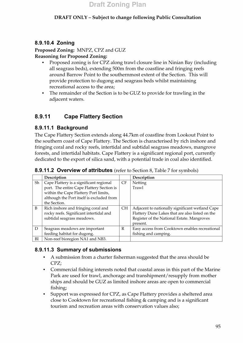
DRAFT ONLY – Subject to change following Public Consultation
95
8.9.10.4 Zoning Proposed Zoning: MNPZ, CPZ and GUZ Reasoning for Proposed Zoning:
• Proposed zoning is for CPZ along trawl closure line in Ninian Bay (including all seagrass beds), extending 500m from the coastline and fringing reefs around Barrow Point to the southernmost extent of the Section. This will provide protection to dugong and seagrass beds whilst maintaining recreational access to the area;
• The remainder of the Section is to be GUZ to provide for trawling in the adjacent waters.
8.9.11 Cape Flattery Section
8.9.11.1 Background The Cape Flattery Section extends along 44.7km of coastline from Lookout Point to the southern coast of Cape Flattery. The Section is characterised by rich inshore and fringing coral and rocky reefs, intertidal and subtidal seagrass meadows, mangrove forests, and intertidal habitats. Cape Flattery is a significant regional port, currently dedicated to the export of silica sand, with a potential trade in coal also identified.
8.9.11.2 Overview of attributes (refer to Section 8, Table 7 for symbols) Description Description Sh Cape Flattery is a significant regional
port. The entire Cape Flattery Section is within the Cape Flattery Port limits, although the Port itself is excluded from the Section.
CF Netting Trawl
B Rich inshore and fringing coral and rocky reefs. Significant intertidal and subtidal seagrass meadows.
CH Adjacent to nationally significant wetland Cape Flattery Dune Lakes that are also listed on the Register of the National Estate. Mangroves present.
D Seagrass meadows are important feeding habitat for dugong.
R Easy access from Cooktown enables recreational fishing and camping.
BI Non-reef bioregion NA1 and NB3.
8.9.11.3 Summary of submissions • A submission from a charter fisherman suggested that the area should be
CPZ; • Commercial fishing interests noted that coastal areas in this part of the Marine
Park are used for trawl, anchorage and transhipment/resupply from mother ships and should be GUZ as limited inshore areas are open to commercial fishing;
• Support was expressed for CPZ, as Cape Flattery provides a sheltered area close to Cooktown for recreational fishing & camping and is a significant tourism and recreation areas with conservation values also;
DRAFT ONLY – Subject to change following Public Consultation
96
• Specific zoning suggestions from recreational fishing interests included no MNPZ south of Cape Flattery, but MNPZ north of the Cape is acceptable as there is limited access to this area;
• Conservation interests asked for the Section to be MNPZ to encompass the existing trawl closure area, to protect seagrass, dugong habitat, inshore dolphin habitat, and consolidate several small MNPZ into a single large zone.
8.9.11.4 Zoning Proposed Zoning: HPZ and GUZ Reasoning for Proposed Zoning:
• The proposed zoning extends the existing area of HPZ under the Cairns Marine Park to include the inshore areas of Flattery Harbour from Lookout Point to Decapolis Reef and back into Cape Flattery, incorporating the extent of the trawl closure (including seagrass beds);
• The remainder of the Section is proposed to be GUZ to provide for continued trawling in adjacent waters;
• Decapolis Reef and surrounding waters to 500m remains MNPZ; • The impacts of the proposed zoning on Port operations will be minimal as the
proposed HPZ is outside the shipping area and away from all major port facilities (although it is within the Cape Flattery Port Limits).
8.9.12 Cooktown Section
8.9.12.1 Background The Cooktown Section, which includes 68 km of coastline from Cape Bedford to Walker Bay, is characterised by sandstones overlain by clay, silt and sands. Rocky headlands, wide tidal creek systems, and exposed sandy beaches bound the area. The area supports soft bottom marine communities, sparse seagrasses and various shoals (Draper Patch and Blackbird Patches). It includes the mouth of the Endeavour River at Cooktown, which has cultural heritage values.

DRAFT ONLY – Subject to change following Public Consultation
97
8.9.12.2 Overview of attributes (refer to Section 8, Table 7 for symbols)
8.9.12.3 Summary of submissions • Some submissions noted that the Section is popular for recreational fishing
and tourism and should not be MNPZ; • Commercial fishing interests noted that coastal areas in this part of the Marine
Park are used for trawl, anchorage and transhipment/resupply from mother ships and should be GUZ as limited inshore areas are open to commercial fishing;
• One submission outlined that coastal areas between Cairns and Cooktown should be CPZ as they are an integral part of the Daintree/Wet Tropics World Heritage Area;
• Specific zoning suggestions included banning gill netting in Walker Bay to provide enhanced recreational fishing opportunities for tourists and locals. Walker Bay has high conservation, scenic, amenity values. Other areas suggested in submissions for closure to netting included Indian Head – Walker Bay and Weary Bay form Kangaji Point to Rattlesnake Point;
• A submissions noted that the area around Cape Bedford is a good anchorage; • Another submissions stated that Bedford and Walker Bay offer sheltered areas
close to Cooktown for recreational fishing & camping; • A commercial fishing submissions also noted that Bedford Bay is a safe
anchorage which makes it an important fishing area for shark, mackerel and bait;
• One submission suggested that the area from Archer Pont to Thomas Point is important for recreational fishing and should be closed to netting.
Description Description CH Coastal dune area of Endeavour
River mouth is a landscape feature of natural heritage significance. Cape Flattery dunes are adjacent to the Section and are nationally significant and listed on the Register of the National Estate.
H Significant cultural heritage values associated with Captain Cooks landing in 1770. Historic shipwrecks; Exchange – sunk 1884, Wong and Hing – both sunk 1887, Pauan - sunk 1907, Isabella – sunk 1914, Kestrel – sunk 1906, Sea Breeze – sunk 1919 and Ruby – sunk 1884.
B Supports soft bottom marine communities, and various shoals. Significant areas of seagrass in Walker Bay.
R Annan & Endeavour Rivers used for recreational fishing.
NP Endeavour River National Park and Mount Cook National Park.
TS Charter fishers and dive tourism operations visit local reefs out of Cooktown.
A Cooktown. CF Netting Trawl Pearl aquaculture in Walker Bay.
P Cooktown is a regional fishing port, boat ramps
BI Non-reef bioregion NA1, NA3 and NB3. Reef bioregion RE2.
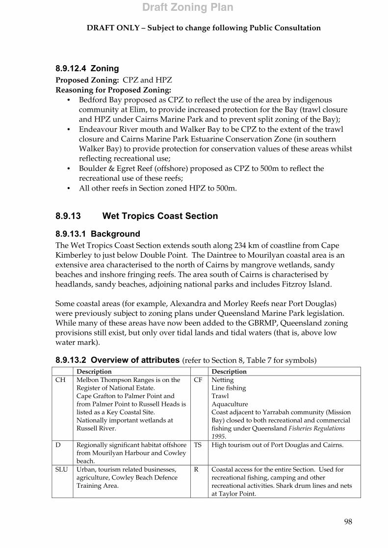
DRAFT ONLY – Subject to change following Public Consultation
98
8.9.12.4 Zoning Proposed Zoning: CPZ and HPZ Reasoning for Proposed Zoning:
• Bedford Bay proposed as CPZ to reflect the use of the area by indigenous community at Elim, to provide increased protection for the Bay (trawl closure and HPZ under Cairns Marine Park and to prevent split zoning of the Bay);
• Endeavour River mouth and Walker Bay to be CPZ to the extent of the trawl closure and Cairns Marine Park Estuarine Conservation Zone (in southern Walker Bay) to provide protection for conservation values of these areas whilst reflecting recreational use;
• Boulder & Egret Reef (offshore) proposed as CPZ to 500m to reflect the recreational use of these reefs;
• All other reefs in Section zoned HPZ to 500m.
8.9.13 Wet Tropics Coast Section
8.9.13.1 Background The Wet Tropics Coast Section extends south along 234 km of coastline from Cape Kimberley to just below Double Point. The Daintree to Mourilyan coastal area is an extensive area characterised to the north of Cairns by mangrove wetlands, sandy beaches and inshore fringing reefs. The area south of Cairns is characterised by headlands, sandy beaches, adjoining national parks and includes Fitzroy Island. Some coastal areas (for example, Alexandra and Morley Reefs near Port Douglas) were previously subject to zoning plans under Queensland Marine Park legislation. While many of these areas have now been added to the GBRMP, Queensland zoning provisions still exist, but only over tidal lands and tidal waters (that is, above low water mark).
8.9.13.2 Overview of attributes (refer to Section 8, Table 7 for symbols) Description Description CH Melbon Thompson Ranges is on the
Register of National Estate. Cape Grafton to Palmer Point and from Palmer Point to Russell Heads is listed as a Key Coastal Site. Nationally important wetlands at Russell River.
CF Netting Line fishing Trawl Aquaculture Coast adjacent to Yarrabah community (Mission Bay) closed to both recreational and commercial fishing under Queensland Fisheries Regulations 1995.
D Regionally significant habitat offshore from Mourilyan Harbour and Cowley beach.
TS High tourism out of Port Douglas and Cairns.
SLU Urban, tourism related businesses, agriculture, Cowley Beach Defence Training Area.
R Coastal access for the entire Section. Used for recreational fishing, camping and other recreational activities. Shark drum lines and nets at Taylor Point.

DRAFT ONLY – Subject to change following Public Consultation
99
Description Description B Offshore from Mourilyan Harbour
and Cowley beach. Inshore reefs north and south of Port Douglas.
A Daintree, Newell, Mossman, Port Douglas, Craiglie, Clifton Beach, Yarrabah, Babinda, Bramston Beach, Innisfail, Mourilyan.
Sh
High shipping traffic to Port of Cairns and Port of Mourilyan. Cairns is home to one of Queenland’s largest fishing fleets, is Queensland’s busiest commercial tourist port and developing as a significant port for international cruise ships and has an extensive ship building industry. Mourilyan is an important sugar and molasses loading facility.
H Historic shipwrecks, Dove – sunk 1911, Rose and Thistle – sunk 1882 and Fitzroy – sunk 1897.
P Port of Cairns (partly excluded from section) Port of Mourilyan (excluded) and numerous jetties, marinas and boat ramps.
BI Non-reef bioregion NA3 and NB5. Reef bioregion RE2 and RE3.
NP Ella Bay, Russell River and Moresby Range National Parks.
8.9.13.3 Summary of submissions • Submissions expressed support for the Section to be zoned mostly CPZ. This
is because the Section abuts a high population area in which recreational camping, fishing, spearfishing and snorkelling are popular;
• Submissions claim that zoning the Section CPZ will lower the turbidity that impacts on the fringing reef due to reduced fishing effort and the removal of trawling;
• A submission asked that the Section be MNPZ in order to improve inshore fishing in years to come;
• Some submissions suggested a combination of zoning in the Section with representation of reef ecosystems in MNPZ, the majority of recreational fishing accommodated in CPZ and the needs of the tourism industry provided for;
• Support was expressed for GUZ to allow for major port facilities and commercial fishing. It was stated that commercial fishing is limited, but important to the local economy;
• Specific zoning suggestions included 2nm or wider MNPZ buffer from Cape Kimberley to Snapper Island in order to allow tourists (especially kayakers) unhindered views;
• Concerns regarding the effects of trawling supported a call for Unity Reef to be MNPZ;
• A submission suggested MNPZ from Slip Cliff Point to Simpson Point and the coast off Yarrabah;
• It was noted that dugongs are frequently sighted from Port Douglas north to Cape Kimberley and this area should be MNPZ to protect the dugongs;
• It was suggested that Double Island North to Port Douglas should be MNPZ due to the numerous tourists in this area. It was also stated that there are many turtles and dugongs present in the coastal reefs;
• A submission observed that net fishing and trawling is depleting breeding stocks of all species of fish and black tiger prawns from Flying Fish Point north to Flirt Point;

DRAFT ONLY – Subject to change following Public Consultation
100
• Another suggestion was that inshore from Cape Kimberley to Alexandra Reefs should not be MNPZ as this is a bait area for mullet, gar, sardines etc.;
• A submission stated that Port Douglas north to the Daintree River is subject to strong trade winds which reduces the amount of time spent fishing in this area;
• Another submission suggested that False Cape to Fitzroy Island should be MNPZ as this is a less populated area and less accessible to most people.
8.9.13.4 Zoning Proposed Zoning: MNPZ, CPZ, HPZ and GUZ Reasoning for Proposed Zoning:
• MNPZ from northern mouth of Daintree River and MNPZ area south of Snapper Island to join MNPZ encompassing Snapper Island will avoid high commercial fishing use areas, provide a buffer to adjacent wetlands and protect the natural values in this area utilised by tourism operators;
• MNPZ adjacent to Port Douglas will protect the natural values of this area and address community concerns regarding providing an area free from recreational fishing. Submissions indicated that this area is less important as a recreational fishing area than adjacent areas along the coast.
• MNPZ along the coast south of Alexandra Shoals for a distance of approximately 10km out to the width of the entire Section will provide protection to Garioch Reef and Unity Reef and restrict fishing usage in a less accessible area of the coastline;
• Fitzroy Island is zoned as CPZ to a distance of approximately 1km. Outside this 1km buffer on the eastern side of Fitzroy Island is zoned MNPZ which extends east out of the Section to join a large candidate area of MNPZ. This will allow recreational fishing to occur around Fitzroy Island in the CPZ. The MNPZ will protect the natural values of the area which is minimally used for fishing;
• MNPZ adjacent to the Russell River National Park and nationally significant wetlands will provide a buffer to coastal habitat and provide protection to the marine environment in this area;
• CPZ out to an average distance of 3km off the coast to meet the HPZ north of Port Douglas and south to encompass the Alexandra Reefs reflecting previous State zoning;
• CPZ in Mission Bay to reflect current usage by the Yarrabah community; • 500m CPZ buffer around the eastern side of Snapper Island and HPZ at Wide
Bay and Deception Point to the point just south of Gunjurra Island to mirror previous State zoning;
• HPZ from south of the mouth of the Daintree River south to Port Douglas and from Taylor Point north to just south of Simpson Point including Double Island and Haycock Reef so as to reflect the existing area closed to trawling under the Fisheries (East Coast Trawl) Management Plan 1999;
• HPZ from across the southernmost part of the Section south of the Mourilyan Harbour exclusion in a small east-west sliver at Double Point so as to reflect the existing area closed to trawling under the Mission Beach Trawl Closure;
DRAFT ONLY – Subject to change following Public Consultation
101
• HPZ from Palmer Point to Constantine Point out to the border of the Section so as to provide a buffer of protection to wetlands along the coast;
• HPZ from Cooper Point to the southernmost point of Ella Bay National Park where it meets the coast to act as a buffer to the National Park and associated wetlands;
• GUZ for the rest of the Section.
8.9.14 Clump Point Section
8.9.14.1 Background The Bingil Bay- Clump Point area extends 19.7 km along the coast and is characterised by acid volcanic rocks overlain by clay, silt and sand. The inshore waters support scattered soft bottom communities, including diverse soft corals, hydrozoans, and macroalgae. Issues include submarine cables, moorings and a proposed marina.
8.9.14.2 Overview of attributes (refer to Section 8, Table 7 for symbols) Description Description B Scattered soft bottom
communities, including diverse soft corals, hydrozoans, and macroalgae.
CF Netting Line fishing Trawl
CH Wetlands and mangroves adjacent to the north of the Section.
R High access enables recreational fishing, boating, kayaking and other recreational activities.
NP Clump Mountain National Park. P Four boat ramps. Mourilyan Harbour limits encompasses the northern half of the Section.
TS Medium tourism use. Mission Beach is a tourist departure point to the reef.
A Bingil Bay and Mission Beach.
SLU Urban, agriculture, aquaculture. BI Non-reef bioregion NA3 and NB3. Reef bioregion RE3.
8.9.14.3 Summary of submissions • Submissions stated that the Section should remain open to recreational fishing,
particularly beach fishing and off the jetty. It was noted that this is a protected area for small boats in south-east trade winds and provides safe recreational fishing for both tourists and locals. It was requested that the Section not be zoned MNPZ;
• A few recreational fishing interests submissions suggested that Bingil Bay should be MNPZ to maintain and improve the marine life located here;
• A submission noted that there is good spearfishing around Clump Point and this area should not be MNPZ;
• One submission asked that zoning remove fishing from this Section; • CPZ zoning was suggested for Boat Bay as there is a high diversity of marine
life in this area.
DRAFT ONLY – Subject to change following Public Consultation
102
8.9.14.4 Zoning Proposed Zoning: MNPZ, CPZ and HPZ Reasoning for Proposed Zoning:
• MNPZ is proposed from south of Murdering Point to approximately 1km north along the coast from the Maria Creek mouth in order to protect reef communities, and provide a buffer to adjacent wetlands, mangroves and Maria Creek National Park. The MNPZ incorporates only the southern end of the King Reefs, the rest will be CPZ in recognition of their popularity as a recreational fishing spot;
• In order to offer a level of protection to inshore soft bottom communities and to reflect the high amount of recreational use, including recreational fishing and associated activities which occur, CPZ will be placed from south of Clump Point to Tam O’Shanter Point (in the Mission Beach Section);
• The remainder of the Section will be zoned HPZ so as to reflect the existing area closed to trawling through the Great Barrier Reef Marine Park Regulations 1983.
8.9.15 Mission Beach Section
8.9.15.1 Background The Mission Beach – Tully Heads area is characterised by acid volcanic rocks overlain by clay, silt and sand. The inshore waters support scattered soft bottom communities, including diverse soft corals, hydrozoans, and macroalgae. Issues in the Section include stormwater discharge and boat ramps.
8.9.15.2 Overview of attributes (refer to Section 8, Table 7 for symbols) Description Description SLU Urban, Black Tiger Prawn
aquaculture farm at Tamoshanter Point.
CF Netting Line fishing Trawl
P Boat ramps, Marina on the Hull River, transit point to Dunk Island.
R Ease of access enables recreational fishing, boating, swimming, snorkelling and camping.
FHA Present H Unidentified shipwreck – sunk 1927 NP Hull River National Park.
Kennedy walking track finishes at the mouth of Hull River.
B North of Tam O’Shanter Point and adjacent to Dunk Island. Inshore scattered soft bottom communities, including diverse soft corals, hydrozoans, and macroalgae.
A Wongaling Beach, Tully Heads. TS Medium amount of tourism use. BI Non-reef bioregion NA3 and
NB3. Reef bioregion RE3.
8.9.15.3 Summary of submissions • A submission stated that this Section has easy and safe access for small boats,
allowing fishing, boating and coral viewing to occur throughout the Section; • Submissions noted that this Section should not be MNPZ as it has good fish
stocks and is popular for recreational fishing and spearfishing;
DRAFT ONLY – Subject to change following Public Consultation
103
• Some submissions outlined the exceptional natural values of the area and asked for MNPZ as the area is good for sightseeing;
• Submissions from commercial fishermen outlined the commercial value of the area and asked for it to be GUZ;
• Numerous submissions called for fishing to be removed from this Section; • A submission noted that the southern half of the Section is not accessible by
land and therefore is not used for beach fishing, snorkelling or spearfishing. • The northern half of the Section is mainly used for fishing, however it is not
suitable for beach fishing as there are no reefs or rocks. Zone MNPZ; • Another submission pointed out that Tam O’Shanter Point is a fishing area
which is very popular with tourists who walk the Kennedy Track; • A number of submissions expressed that they wished to remove netting from
parts of the Section.
8.9.15.4 Zoning Proposed Zoning: MNPZ, CPZ and HPZ Reasoning for Proposed Zoning:
• In order to offer a level of protection to inshore soft bottom communities and to reflect the high amount of recreational use, including recreational fishing and associated activities, CPZ will be placed from south of Clump Point (in the Clump Point Section) to Tam O’Shanter Point;
• The area adjacent to Hull River National Park (from the northern side of Tam O’Shanter Point to the northern side of the Hull River Mouth) will be MNPZ. This will address community concerns about conserving areas for nature enjoyment, especially in remote access areas, provide protection to reef area and act as a buffer to the adjacent Hull River National Park;
• The remainder of the Section will be HPZ so as to reflect the existing area closed to trawling through the Great Barrier Reef Marine Park Regulations 1983.
8.9.16 Halifax Bay Section
8.9.16.1 Background The Lucinda - Bohle River coastal area is characterised by sandy beaches and broad intertidal sand flats. Extensive mangrove communities are found to the north of the area. The area also consists of extensive seagrass beds to the south of Lucinda. A number of shoals and small reefal areas are located offshore in the southern part of the area.

DRAFT ONLY – Subject to change following Public Consultation
104
8.9.16.2 Overview of attributes (refer to Section 8, Table 7 for symbols) Description Description D Significant dugong habitat in the
north of the Section. Taylors Beach Dugong Protection Area and the Cleveland Bay – Magnetic Island Dugong Protection Area.
CF Netting Trawl
T Important green turtle foraging area. R Ease of access enables recreational fishing throughout the Section.
P Boat ramps and beach access is available along the entire Section by vehicle or foot.
A Allingham, Jalloonda, Mount Low, Balgal Beach, Taylors Beach, Palleranda, Toomulla, Toolakea, Rollingstone and Saunders Beach.
NP Clemant Forest Reserve, Halifax Bay Wetlands National Park.
FHA Present
CH 2 wetlands of national importance, the Bambaroo Coastal Aggregation and Herbert River Flood Plain. Extensive mangrove communities to the north of the area.
Sh Port of Lucinda, adjacent to the northern boundary of the Section, is specifically dedicated to the export of sugar. The 5km offshore jetty is the longest such facility in the southern hemisphere.
SLU Urban, agriculture – sugar cane. An outlet pipe is offshore from Qld Nickel.
B Extensive seagrass beds to the south of Lucinda. A number of shoals and small reefal areas are located offshore in the Section
BI Non-reef bioregion NA3. Reef bioregion RE3.
8.9.16.3 Summary of submissions • Submissions noted that turtle foraging sites are present within the Section; • There is support for maintaining access for recreational fishing, particularly
beach fishing, within the Section. One submission suggested a 500 metre buffer from the beach to allow recreational fishing;
• The lower commercial use in the area as opposed to other areas of the Marine Park was raised;
• The need for some coastal areas to be protected was raised. Certain parts of this Section are remote enough not to vastly inconvenience Ingham or Townsville fisherman if MNPZ;
• A replenishment area in the middle of Halifax Bay was suggested; • A submission requested that mackerel aggregation sites in Halifax Bay be
protected.
8.9.16.4 Zoning Proposed Zoning: MNPZ, CPZ and HPZ Reasoning for Proposed Zoning:
• MNPZ is proposed between Insulator Creek and Palm Creek. The MNPZ helps protect the significant biological values in the area and received support in submissions;
DRAFT ONLY – Subject to change following Public Consultation
105
• CPZ is proposed for the West Channel and extends in to the Section at its southernmost point. CPZ will provide protection to significant seagrass communities and dugong, while providing for recreational fishing to continue;
• HPZ 500m around Paluma shoals, Lady Elliot Reef and Unnamed Reef 18-800 as consistent with zone placement guidelines;
• The remainder of the section will be GUZ to maintain commercial fishing opportunities within the Section.
8.9.17 Cleveland Bay Section
8.9.17.1 Background The Cleveland Bay coastal area forms part of the Townsville Coastal Plains and is characterised by mangrove communities, offshore mudflats and extensive seagrass beds. High densities of turtle and dugong are supported by the seagrass beds. The Port of Townsville, much of which is excluded from the new Section, is Queensland’s third largest industrial port and includes dredged approach channels, nine operational berths, a large reclaimed area and associated facilities.
8.9.17.2 Overview of attributes (refer to Section 8, Table 7 for symbols) Description Description T A substantial and significant
population of green turtles CF Netting
Trawl Line fishing
D A significant dugong habitat in the adjacent Cleveland Bay – Magnetic Island DPA ‘A’.
B Cleveland Bay contains important and dense seagrass communities.
A Townsville. H Historic shipwrecks, Ariel – sunk 1865 and Flying Scud – sunk 1890.
CH Burdekin – Townsville Coastal Aggregation is a wetland of national significance and of international significance as a migratory wader habitat (a RAMSAR site). Mangroves present along coast.
S Burdekin – Townsville Coastal Aggregation provides habitat for a number of threatened marine fauna and 13 species of endangered and vulnerable bird species. 50% of species listed under migratory bird agreements (CAMBA or JAMBA) occur in the wetlands.
Sh Within the Townsville port limits P Boat ramps and beach access. SLU Major regional city, port and
industrial zone. Includes a large reclaimed area within the port.
R Ease of access enables recreational fishing throughout the Section.
NP Cape Cleveland National Park, which is nationally important, and Bowling Green National Park
BI Non-reef bioregion NA3.
8.9.17.3 Summary of submissions • Submissions noted that there is easy access for recreational fishermen in this
Section. Support was expressed for maintaining access for recreational fishing, particularly along the coast;
• It was suggested that commercial use of the area should be reduced through zoning in order to reduce impacts on the environment;

DRAFT ONLY – Subject to change following Public Consultation
106
• Submissions raised conservation issues including protecting seagrass, dugongs and turtles.
8.9.17.4 Zoning Proposed Zoning: CPZ and GUZ Reasoning for Proposed Zoning:
• CPZ is proposed for approximately half of the Section, joining to adjacent CPZ outside the Section, in order to provide protection to the many natural values of the area including significant dugong habitat, wetlands, extensive and significant seagrass communities and provide a buffer of protection to adjacent national park. CPZ will address community concerns raised in submissions;
• The remainder of the Section will be GUZ to allow current commercial fishing use of this part of the Section to continue.
8.9.18 Burdekin Section
8.9.18.1 Background The Burdekin Delta area from Alva Beach to Peters Island is characterised by the deltaic sediments carried by the Burdekin River to its mouth, including alluvial clays, silts, sands and gravels. The Burdekin River is the largest single sediment source to the central Great Barrier Reef lagoon, and capable of high volume water flows during seasonal rainfall events. Because of the high sediment loads carried into the area by the Burdekin River, the area does not support well-developed coral reefs, and soft bottom marine communities dominate the area.
8.9.18.2 Overview of attributes (refer to Section 8, Table 7 for symbols) Description Description CF Netting
Trawl Crabbing Line fishing
CH The Burdekin River is the largest single sediment source to the central Great Barrier Reef lagoon. Nationally important wetland - the Burdekin Delta Aggregation. Extensive mangrove communities also in Section
D Southern end of the Section abuts the Upstart Bay Dugong Protection Area
R Ease of access enables recreational fishing throughout the Section.
FHA Present. TS Recreational fishing associated tourism. SLU Agriculture – sugar cane and beef
cattle grazing. BI Non-reef bioregion NA3.
A Ayr and Home Hill. P High number of boat ramps.
8.9.18.3 Summary of submissions • Submissions state that most of the Burdekin’s fishing (both recreational and
commercial) is carried out in this area. • The Section is used intensively for recreational fishing, and this fishing is
central to many residents’ way of life, and is also vital for tourism in the area;
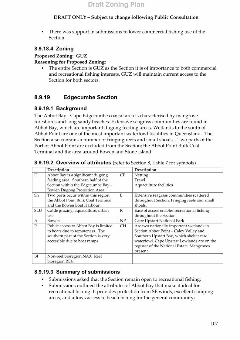
DRAFT ONLY – Subject to change following Public Consultation
107
• There was support in submissions to lower commercial fishing use of the Section.
8.9.18.4 Zoning Proposed Zoning: GUZ Reasoning for Proposed Zoning:
• The entire Section is GUZ as the Section it is of importance to both commercial and recreational fishing interests. GUZ will maintain current access to the Section for both sectors.
8.9.19 Edgecumbe Section
8.9.19.1 Background The Abbot Bay - Cape Edgecumbe coastal area is characterised by mangrove foreshores and long sandy beaches. Extensive seagrass communities are found in Abbot Bay, which are important dugong feeding areas. Wetlands to the south of Abbot Point are one of the most important waterfowl localities in Queensland. The Section also contains a number of fringing reefs and small shoals. . Two parts of the Port of Abbot Point are excluded from the Section; the Abbot Point Bulk Coal Terminal and the area around Bowen and Stone Island.
8.9.19.2 Overview of attributes (refer to Section 8, Table 7 for symbols) Description Description D Abbot Bay is a significant dugong
feeding area. Southern half of the Section within the Edgecumbe Bay – Bowen Dugong Protection Area.
CF Netting Trawl Aquaculture facilities
Sh Two ports occur within this region, the Abbot Point Bulk Coal Terminal and the Bowen Boat Harbour.
B Extensive seagrass communities scattered throughout Section. Fringing reefs and small shoals.
SLU Cattle grazing, aquaculture, urban use.
R Ease of access enables recreational fishing throughout the Section.
A Bowen NP Cape Upstart National Park P Public access to Abbot Bay is limited
to boats due to remoteness. The southern part of the Section is very accessible due to boat ramps.
CH Are two nationally important wetlands in Section Abbot Point – Caley Valley and Southern Upstart Bay, which shelter rare waterfowl. Cape Upstart Lowlands are on the register of the National Estate. Mangroves present.
BI Non-reef bioregion NA3. Reef bioregion RE4.
8.9.19.3 Summary of submissions • Submissions asked that the Section remain open to recreational fishing; • Submissions outlined the attributes of Abbot Bay that make it ideal for
recreational fishing. It provides protection from SE winds, excellent camping areas, and allows access to beach fishing for the general community;
DRAFT ONLY – Subject to change following Public Consultation
108
• Some submissions called for greater protection of estuaries and seagrass to conserve fish;
• Some submissions called for reducing or banning commercial fishing through zoning;
• One submission stated that Queens Bay to Cape Edgecumbe is an area used by recreational fishermen and tourists in the Bowen area;
• One suggestion suggested zoning the area south of Station creek, which is patchy reef and rubble, MNPZ. It was stated that pelagic species arrive in season in this area and it is not as accessible as Camp Island due to weather conditions;
• Another submission noted that Camp Island to Elliot River is a very important fishing area with good inshore reefs for fishing, snorkelling and spearfishing.
8.9.19.4 Zoning Proposed Zoning: HPZ and GUZ Reasoning for Proposed Zoning:
• Camp Island south along the foreshore to the edge of the Abbot Point Bulk Coal Terminal zoned as HPZ to provide a level of protection to seagrass beds and provide a buffer to adjacent national park and nationally important wetlands. HPZ will also allow recreational and most commercial use of the Section to continue.
• HPZ 500m around Unnamed Reef 20-001 as consistent with the zone placement guidelines;
• The remainder of the Section will be GUZ to maintain the high recreational and high commercial fishing use of the Section.
8.9.20 Airlie Section
8.9.20.1 Background The Pioneer Bay coastal area from Bluff Point to Mandalay Point is one of the smaller new coastal Sections as it excludes the area around the Airlie Beach township, Cannonvale and Pigeon Island. Airlie Beach and Cannonvale provide services, facilities and supplies for the tourism industry based in the Whitsundays, while Airlie Beach is a major tourist destination and an important departure point for many tourist operations accessing the Whitsundays.

DRAFT ONLY – Subject to change following Public Consultation
109
8.9.20.2 Overview of attributes (refer to Section 8, Table 7 for symbols) Description Description B Seagrass beds areas along coastline in
Pioneer Bay with dugong feeding tracks often seen.
CF Net Charter
NP Dryander National Park. P Marinas, boat ramps SU Forms part of the high priority
Whitsunday Special Unique site. R Popular for fishing, boating,
swimming/snorkelling, camping. CH Mangroves A Airlie Beach and Cannonvale. SLU Urban use, tourism, sugarcane farming,
cattle grazing, agriculture, small scale manufacturing.
TS Airlie Beach is a major tourist departure point.
BI Non-reef bioregion NA3. Reef bioregion RE4.
8.9.20.3 Summary of submissions • Many submissions expressed concern about the effects the secondary sewage
treatment outfall pipe near Pigeon Island on water quality and seagrass meadows. Some submitters stated they have seen an increase in the amount of filamentous algae and sediments in recent years;
• Submissions reported dugong and dugong feeding tracks, and were concerned about the loss of dugong from the area;
• Some submissions wanted a limitation on mooring and anchoring within Pioneer Bay for dugong conservation;
• Submissions called for access to the Section for recreational fishing and crabbing, which was highlighted as particularly important for land-based anglers;
• Submissions discussed the importance of the Section as an access point to the Whitsundays, and wanted this to be considered in the rezoning;
• Zoning recommended was GUZ, CPZ and MNPZ.
8.9.20.4 Zoning Proposed Zoning: CPZ Reasoning for Proposed Zoning:
• CPZ will provide protection for the seagrass beds and dugongs that are often seen feeding in the area. CPZ will also complement the adjacent Dryander National Park. CPZ will have minimal impact on commercial fishing as little effort takes place in the Section. CPZ addresses concerns highlighted in submissions allowing residents of and tourists to Airlie Beach and Cannonvale to continue recreational activities in the Section.
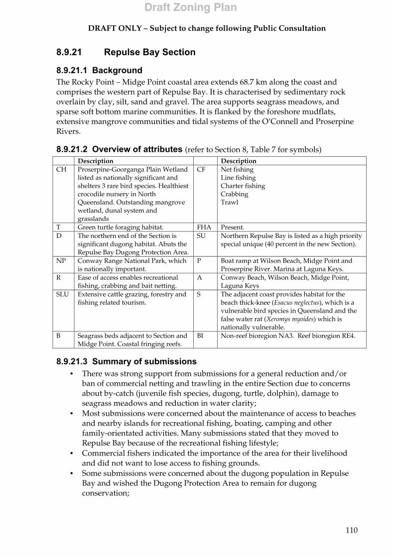
DRAFT ONLY – Subject to change following Public Consultation
110
8.9.21 Repulse Bay Section
8.9.21.1 Background The Rocky Point – Midge Point coastal area extends 68.7 km along the coast and comprises the western part of Repulse Bay. It is characterised by sedimentary rock overlain by clay, silt, sand and gravel. The area supports seagrass meadows, and sparse soft bottom marine communities. It is flanked by the foreshore mudflats, extensive mangrove communities and tidal systems of the O’Connell and Proserpine Rivers.
8.9.21.2 Overview of attributes (refer to Section 8, Table 7 for symbols) Description Description CH Proserpine-Goorganga Plain Wetland
listed as nationally significant and shelters 3 rare bird species. Healthiest crocodile nursery in North Queensland. Outstanding mangrove wetland, dunal system and grasslands
CF Net fishing Line fishing Charter fishing Crabbing Trawl
T Green turtle foraging habitat. FHA Present. D The northern end of the Section is
significant dugong habitat. Abuts the Repulse Bay Dugong Protection Area.
SU Northern Repulse Bay is listed as a high priority special unique (40 percent in the new Section).
NP Conway Range National Park, which is nationally important.
P Boat ramp at Wilson Beach, Midge Point and Proserpine River. Marina at Laguna Keys.
R Ease of access enables recreational fishing, crabbing and bait netting.
A Conway Beach, Wilson Beach, Midge Point, Laguna Keys
SLU Extensive cattle grazing, forestry and fishing related tourism.
S The adjacent coast provides habitat for the beach thick-knee (Esacus neglectus), which is a vulnerable bird species in Queensland and the false water rat (Xeromys myoides) which is nationally vulnerable.
B Seagrass beds adjacent to Section and Midge Point. Coastal fringing reefs.
BI Non-reef bioregion NA3. Reef bioregion RE4.
8.9.21.3 Summary of submissions • There was strong support from submissions for a general reduction and/or
ban of commercial netting and trawling in the entire Section due to concerns about by-catch (juvenile fish species, dugong, turtle, dolphin), damage to seagrass meadows and reduction in water clarity;
• Most submissions were concerned about the maintenance of access to beaches and nearby islands for recreational fishing, boating, camping and other family-orientated activities. Many submissions stated that they moved to Repulse Bay because of the recreational fishing lifestyle;
• Commercial fishers indicated the importance of the area for their livelihood and did not want to lose access to fishing grounds.
• Some submissions were concerned about the dugong population in Repulse Bay and wished the Dugong Protection Area to remain for dugong conservation;
DRAFT ONLY – Subject to change following Public Consultation
111
• Most submissions did not want the Section in MNPZ because of the perceived reduction in visitation and tourism dollars, which help sustain many local businesses;
• Some submissions were concerned about the possible devaluation of homes and businesses if the Section was MNPZ;
• Some areas were suggested as MNPZ because of the important fish breeding and nursery grounds in the Section;
• Alternatives suggested to MNPZ were reduction in bag and size limits, seasonal closures and reduction in commercial fishing effort;
• Zoning requested was HPZ, CPZ and MNPZ.
8.9.21.4 Zoning Proposed Zoning: MNPZ and CPZ Reasoning for Proposed Zoning:
• The majority of the Section is CPZ with the centre of Repulse Bay MNPZ. CPZ will extend from Cape Conway across to the mouth of the Proserpine River and then south around Midge Point. MNPZ extends west from (but does not include) the Repulse Island Group to meet the boundary of the CPZ.
• Repulse Bay has high recreational values including fishing, boating and other water-based activities. CPZ addresses concerns raised in submissions by allowing recreational fishing and fishing tourism to occur within the Section. CPZ also offers protection to the very significant biological values of the Section including high priority dugong habitat;
• MNPZ offers a higher level of protection to the significant biological values in the Section and helps protect the NA3 High Nutrient Coastal Strip bioregion. MNPZ also addresses support in submissions for zoning part of the Section as MNPZ.
8.9.22 Sandringham Section
8.9.22.1 Background The Shoal Point – Sarina Inlet coastal area is characterised by mangroves and foreshore flats, sandy beaches separated by rocky headlands and includes a number of small islands. Two areas are excluded from the Section; the area including the Mackay harbour facilities from Slade Point to the mouth of the Pioneer River; and the Sandringham Bay area from Bakers Creek in the north to the areas around the Dalrymple Bay Coal Terminal and the Hay Point Coal Terminals in the south. Mackay is an important regional centre servicing agricultural and mining communities, a large commercial fishing fleet, several very large port facilities and several tourist operations. The Port of Hay Point, comprising the two separate coal terminals, caters for one of the highest tonnages of export per annum of any port in Australia (40 million tonnes/annum).
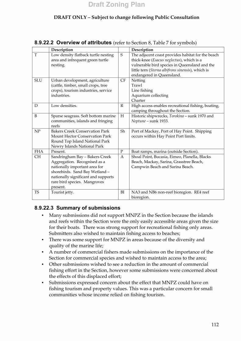
DRAFT ONLY – Subject to change following Public Consultation
112
8.9.22.2 Overview of attributes (refer to Section 8, Table 7 for symbols) Description Description T Low density flatback turtle nesting
area and infrequent green turtle nesting.
S The adjacent coast provides habitat for the beach thick-knee (Esacus neglectus), which is a vulnerable bird species in Queensland and the little tern (Sterna albifrons sinensis), which is endangered in Queensland.
SLU Urban development, agriculture (cattle, timber, small crops, tree crops), tourism industries, service industries.
CF Netting Trawl Line fishing Aquarium collecting Charter
D Low densities. R High access enables recreational fishing, boating, camping throughout the Section.
B Sparse seagrass. Soft bottom marine communities, islands and fringing reefs
H Historic shipwrecks, Torokina – sunk 1970 and Neptune – sunk 1933.
NP Bakers Creek Conservation Park Mount Hector Conservation Park Round Top Island National Park Newry Islands National Park
Sh Port of Mackay, Port of Hay Point. Shipping occurs within Hay Point Port limits.
FHA Present. P Boat ramps, marina (outside Section). CH Sandringham Bay – Bakers Creek
Aggregation. Recognised as a nationally important area for shorebirds. Sand Bay Wetland – nationally significant and supports rare bird species. Mangroves present.
A Shoal Point, Bucasia, Eimeo, Planella, Blacks Beach, Mackay, Sarina, Grasstree Beach, Campwin Beach and Sarina Beach.
TS Tourist jetty. BI NA3 and NB6 non-reef bioregion. RE4 reef bioregion.
8.9.22.3 Summary of submissions • Many submissions did not support MNPZ in the Section because the islands
and reefs within the Section were the only easily accessible areas given the size for their boats. There was strong support for recreational fishing only areas. Submitters also wished to maintain fishing access to beaches;
• There was some support for MNPZ in areas because of the diversity and quality of the marine life;
• A number of commercial fishers made submissions on the importance of the Section for commercial species and wished to maintain access to the area;
• Other submissions wished to see a reduction in the amount of commercial fishing effort in the Section, however some submissions were concerned about the effects of this displaced effort;
• Submissions expressed concern about the effect that MNPZ could have on fishing tourism and property values. This was a particular concern for small communities whose income relied on fishing tourism.
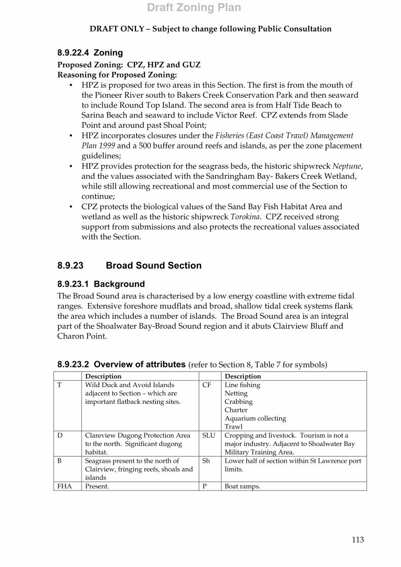
DRAFT ONLY – Subject to change following Public Consultation
113
8.9.22.4 Zoning Proposed Zoning: CPZ, HPZ and GUZ Reasoning for Proposed Zoning:
• HPZ is proposed for two areas in this Section. The first is from the mouth of the Pioneer River south to Bakers Creek Conservation Park and then seaward to include Round Top Island. The second area is from Half Tide Beach to Sarina Beach and seaward to include Victor Reef. CPZ extends from Slade Point and around past Shoal Point;
• HPZ incorporates closures under the Fisheries (East Coast Trawl) Management Plan 1999 and a 500 buffer around reefs and islands, as per the zone placement guidelines;
• HPZ provides protection for the seagrass beds, the historic shipwreck Neptune, and the values associated with the Sandringham Bay- Bakers Creek Wetland, while still allowing recreational and most commercial use of the Section to continue;
• CPZ protects the biological values of the Sand Bay Fish Habitat Area and wetland as well as the historic shipwreck Torokina. CPZ received strong support from submissions and also protects the recreational values associated with the Section.
8.9.23 Broad Sound Section
8.9.23.1 Background The Broad Sound area is characterised by a low energy coastline with extreme tidal ranges. Extensive foreshore mudflats and broad, shallow tidal creek systems flank the area which includes a number of islands. The Broad Sound area is an integral part of the Shoalwater Bay-Broad Sound region and it abuts Clairview Bluff and Charon Point.
8.9.23.2 Overview of attributes (refer to Section 8, Table 7 for symbols) Description Description T Wild Duck and Avoid Islands
adjacent to Section – which are important flatback nesting sites.
CF Line fishing Netting Crabbing Charter Aquarium collecting Trawl
D Clareview Dugong Protection Area to the north. Significant dugong habitat.
SLU Cropping and livestock. Tourism is not a major industry. Adjacent to Shoalwater Bay Military Training Area.
B Seagrass present to the north of Clairview, fringing reefs, shoals and islands
Sh Lower half of section within St Lawrence port limits.
FHA Present. P Boat ramps.
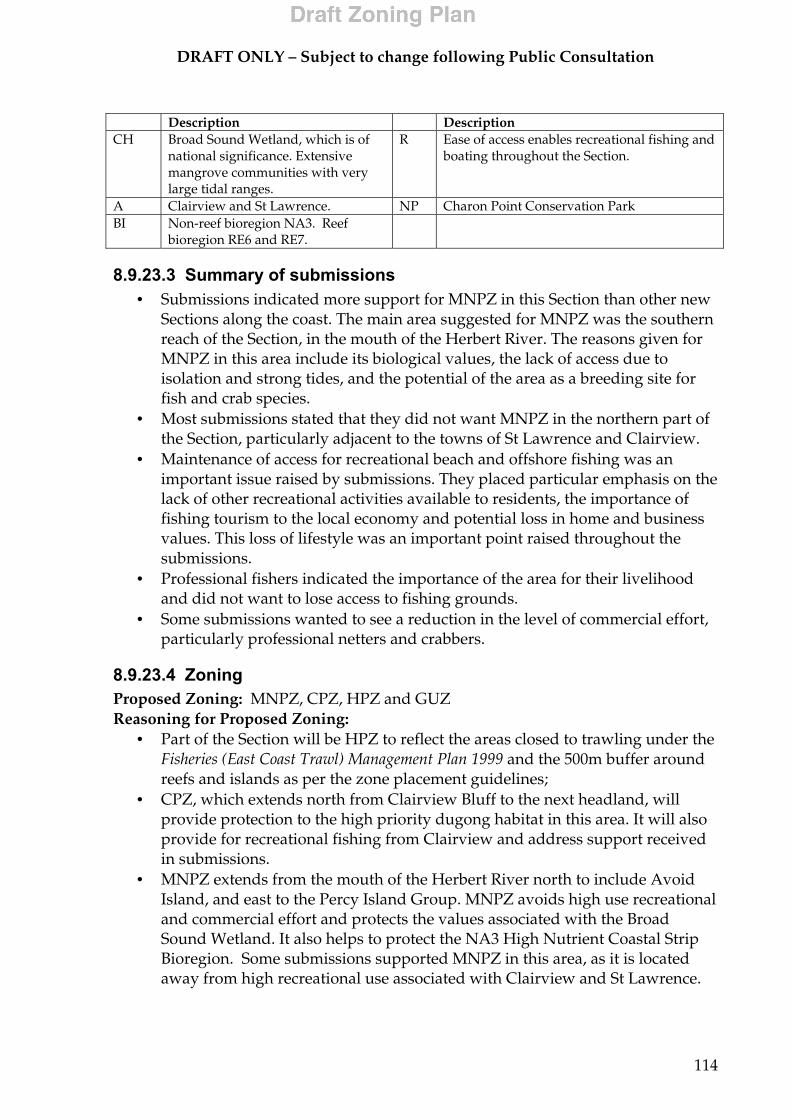
DRAFT ONLY – Subject to change following Public Consultation
114
Description Description CH Broad Sound Wetland, which is of
national significance. Extensive mangrove communities with very large tidal ranges.
R Ease of access enables recreational fishing and boating throughout the Section.
A Clairview and St Lawrence. NP Charon Point Conservation Park BI Non-reef bioregion NA3. Reef
bioregion RE6 and RE7.
8.9.23.3 Summary of submissions • Submissions indicated more support for MNPZ in this Section than other new
Sections along the coast. The main area suggested for MNPZ was the southern reach of the Section, in the mouth of the Herbert River. The reasons given for MNPZ in this area include its biological values, the lack of access due to isolation and strong tides, and the potential of the area as a breeding site for fish and crab species.
• Most submissions stated that they did not want MNPZ in the northern part of the Section, particularly adjacent to the towns of St Lawrence and Clairview.
• Maintenance of access for recreational beach and offshore fishing was an important issue raised by submissions. They placed particular emphasis on the lack of other recreational activities available to residents, the importance of fishing tourism to the local economy and potential loss in home and business values. This loss of lifestyle was an important point raised throughout the submissions.
• Professional fishers indicated the importance of the area for their livelihood and did not want to lose access to fishing grounds.
• Some submissions wanted to see a reduction in the level of commercial effort, particularly professional netters and crabbers.
8.9.23.4 Zoning Proposed Zoning: MNPZ, CPZ, HPZ and GUZ Reasoning for Proposed Zoning:
• Part of the Section will be HPZ to reflect the areas closed to trawling under the Fisheries (East Coast Trawl) Management Plan 1999 and the 500m buffer around reefs and islands as per the zone placement guidelines;
• CPZ, which extends north from Clairview Bluff to the next headland, will provide protection to the high priority dugong habitat in this area. It will also provide for recreational fishing from Clairview and address support received in submissions.
• MNPZ extends from the mouth of the Herbert River north to include Avoid Island, and east to the Percy Island Group. MNPZ avoids high use recreational and commercial effort and protects the values associated with the Broad Sound Wetland. It also helps to protect the NA3 High Nutrient Coastal Strip Bioregion. Some submissions supported MNPZ in this area, as it is located away from high recreational use associated with Clairview and St Lawrence.
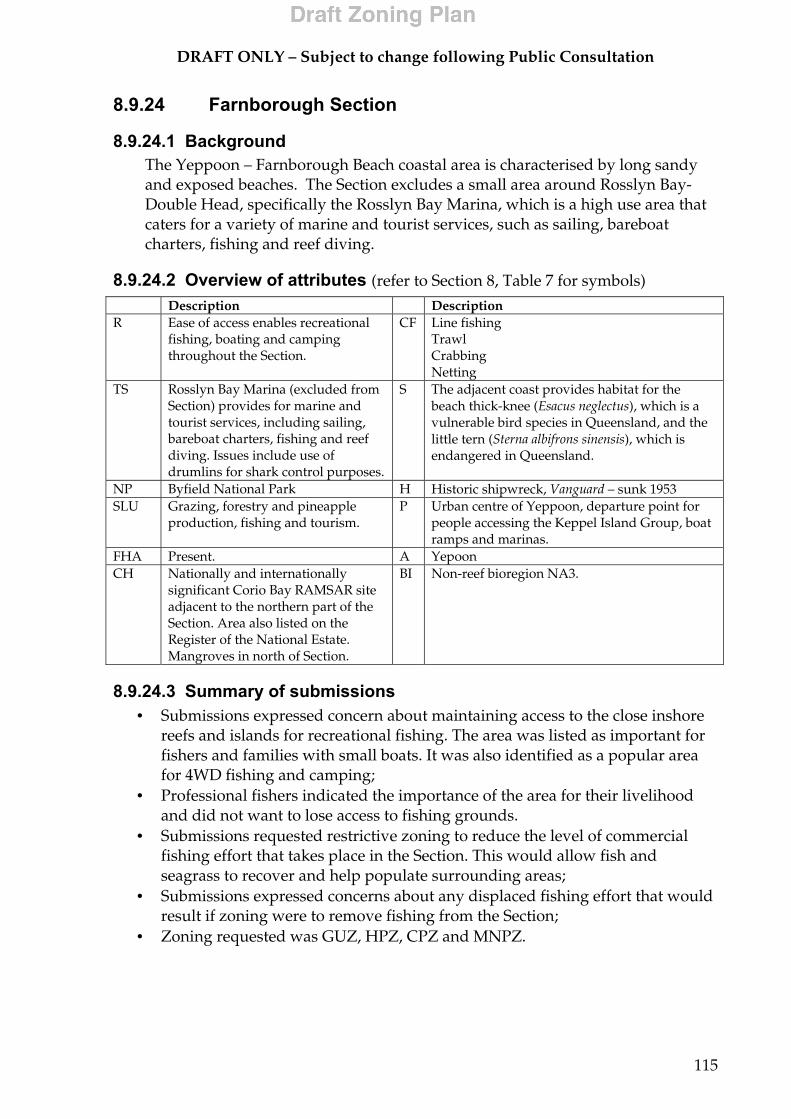
DRAFT ONLY – Subject to change following Public Consultation
115
8.9.24 Farnborough Section
8.9.24.1 Background The Yeppoon – Farnborough Beach coastal area is characterised by long sandy and exposed beaches. The Section excludes a small area around Rosslyn Bay- Double Head, specifically the Rosslyn Bay Marina, which is a high use area that caters for a variety of marine and tourist services, such as sailing, bareboat charters, fishing and reef diving.
8.9.24.2 Overview of attributes (refer to Section 8, Table 7 for symbols)
8.9.24.3 Summary of submissions • Submissions expressed concern about maintaining access to the close inshore
reefs and islands for recreational fishing. The area was listed as important for fishers and families with small boats. It was also identified as a popular area for 4WD fishing and camping;
• Professional fishers indicated the importance of the area for their livelihood and did not want to lose access to fishing grounds.
• Submissions requested restrictive zoning to reduce the level of commercial fishing effort that takes place in the Section. This would allow fish and seagrass to recover and help populate surrounding areas;
• Submissions expressed concerns about any displaced fishing effort that would result if zoning were to remove fishing from the Section;
• Zoning requested was GUZ, HPZ, CPZ and MNPZ.
Description Description R Ease of access enables recreational
fishing, boating and camping throughout the Section.
CF Line fishing Trawl Crabbing Netting
TS Rosslyn Bay Marina (excluded from Section) provides for marine and tourist services, including sailing, bareboat charters, fishing and reef diving. Issues include use of drumlins for shark control purposes.
S The adjacent coast provides habitat for the beach thick-knee (Esacus neglectus), which is a vulnerable bird species in Queensland, and the little tern (Sterna albifrons sinensis), which is endangered in Queensland.
NP Byfield National Park H Historic shipwreck, Vanguard – sunk 1953 SLU Grazing, forestry and pineapple
production, fishing and tourism. P Urban centre of Yeppoon, departure point for
people accessing the Keppel Island Group, boat ramps and marinas.
FHA Present. A Yepoon CH Nationally and internationally
significant Corio Bay RAMSAR site adjacent to the northern part of the Section. Area also listed on the Register of the National Estate. Mangroves in north of Section.
BI Non-reef bioregion NA3.
DRAFT ONLY – Subject to change following Public Consultation
116
8.9.24.4 Zoning Proposed Zoning: CPZ and GUZ Reasoning for Proposed Zoning:
• CPZ from the headland in Statue Bay north to join the CPZ adjacent to Corio Bay. This will complement the adjacent Byfield National Park and provide additional protection for the Corio Bay Wetlands, which shelter endangered species and are of international significance. Many submissions support CPZ in this area.
• The remainder of the Section will be GUZ to maintain commercial fishing opportunities within the Section.
8.9.25 Keppel Bay Section
8.9.25.1 Background The Emu Park- Cattle Point coastal area is characterised by long sandy and exposed beaches and includes Girt Island. The Section does not include Port Alma, part of the Port of Rockhampton.
8.9.25.2 Overview of attributes (refer to Section 8, Table 7 for symbols) Description Description CH Yeppoon-Keppel Sands Tidal
Wetlands is of national significance. Also sandy beaches and rocky headlands with offshore islands and shallow bays.
CF Line fishing Trawl fishing Netting Crabbing Aquarium collecting Charter
SLU Urban development, agriculture
R Fishing, crabbing, tourism, anchorage
FHA Present H Historic shipwrecks, Queensland – sunk 1878 and Raven – sunk 1863.
B Fringing reefs P Boat ramps S The adjacent coast provides
habitat for the beach thick-knee (Esacus neglectus), which is a vulnerable bird species in Queensland.
Sh Port Alma adjacent. Southern part of the section within Port of Rockhampton limits.
A Emu Park, Keppel Sands. NP Keppel Sands Conservation Park BI Non-reef bioregion NA3. Reef
bioregion RE8.
8.9.25.3 Summary of submissions • A large number of commercial fishers made submissions on the importance of
the Section for commercial species and wished to maintain access to the area; • A large number of submissions from recreational fishers requested the area to
be CPZ to reduce gill netting and trawling. The area was highlighted as important for beach and close offshore fishing;
DRAFT ONLY – Subject to change following Public Consultation
117
• The Section was highlighted as important area for camping/fishing activities for families;
• Submissions expressed concern over the devaluation of property if the area was made MNPZ;
• Submissions generally were opposed to MNPZ, however some specific suggestions were made for the Mother McGregor Group due to diversity of marine life and its potential as a breeding area;
• Submissions expressed concern over the displaced fishing effort if the Section had restrictions on extractive activities.
8.9.25.4 Zoning Proposed Zoning: HPZ and GUZ Reasoning for Proposed Zoning:
• Part of the Section will be a HPZ in accordance with the 500m buffer around reefs and islands zone placement guideline. The remainder will be GUZ in order to maintain important commercial fishing opportunities.
8.9.26 Curtis Island Section
8.9.26.1 Background The Curtis Island Section is the smallest of the new coastal areas. The Connor Bluff-North Point area is characterised by fine-grained sedimentary rocks overlain in places by clay, silt and sand. Although small in total area, the Connor Bluff-North Point area supports a sheltered, coastal fringing reef on shelving banks, and is an integral part of the Curtis coast region.
8.9.26.2 Overview of attributes (refer to Section 8, Table 7 for symbols) Description Description D The southern boundary abuts the
Rodds Bay Dugong Protection Area. High priority dugong habitat adjacent to Section.
CF Line fishing Trawl Netting Crabbing Collecting
CH Nationally significant Port Curtis Wetland, which shelters rare bird species
R Ease of access enables recreational fishing, collecting, boating, camping, recreational beach activities.
B Sheltered, coastal fringing reef on shelving banks.
H Curtis Island is on the Register of the National Estate.
Sh Within Port area – navigation of vessels in Section.
P Boat ramp, jetty, marina
T Medium priority flatback nesting sites. Green and loggerhead turtles also present in Section
FHA Present
S The adjacent coast provides habitat for the little tern (Sterna albifrons sinensis), which is endangered in Queensland.
BI Non-reef bioregion NA3. Reef bioregion RE8.

DRAFT ONLY – Subject to change following Public Consultation
118
8.9.26.3 Summary of submissions • There was strong support from submissions for maintaining access to the
Section for recreational fishing. The area is accessed regularly and was highlighted as an important location for family and beach fishing.
• Some submissions wished to see professional worming and spearfishing excluded from the Section.
• Some submissions expressed concerns about any displaced fishing effort. • Submissions identified the Section as a possible candidate for MNPZ due to its
close proximity to and overuse by residents of Gladstone and surrounds. • Zoning recommendations were GUZ, HPZ and MNPZ.
8.9.26.4 Zoning Proposed Zoning: HPZ and GUZ Reasoning for Proposed Zoning:
• North Point Reef and Curtis Island Reef (No4) will be HPZ in accordance with the 500m buffer around reefs and islands zone placement guidelines. The remainder of the Section will be GUZ to maintain recreational and commercial fishing opportunities within the Section.
8.9.27 Boyne Section
8.9.27.1 Background The South of Port Curtis coastal area comprises the southern part of the Port of Gladstone. It adjoins Hummock Hill Island at Tiber Point. The Port of Gladstone, adjacent to the Section, is the largest multi-commodity port in Queensland in terms of trade throughput.
8.9.27.2 Overview of attributes (refer to Section 8, Table 7 for symbols) Description Description D Port of Gladstone – Rodds Bay
Dugong Protection Area. High priority dugong habitat adjacent to Section.
CF Line fishing Trawl Netting Crabbing Collecting (aquarium and coral)
FHA Present. R Fishing, boating, tourism. SLU Agriculture. Sh The Port of Gladstone adjacent to the Section.
Navigation of ships in Section. P Vessel access. B Fringing reefs around Seal Rocks BI Non-reef bioregion NA3 and
NB8. Reef bioregion RE8.
8.9.27.3 Summary of submissions • Seal Rocks, located within the Section, was identified as an important
destination for recreational fishers. These reefs and rocks are one of a few close inshore areas available for fishers from Gladstone/Tannum Sands and Boyne residents and visitors.
DRAFT ONLY – Subject to change following Public Consultation
119
• Submissions highlighted the increase in fishing effort has affected the biodiversity of the area, and suggested either CPZ (to reduce spearfishing and collecting) or MNPZ.
• Submissions discussed the safety aspect involved in making inshore reefs MNPZ, thereby making fishers travel further offshore for the same experience.
• Submissions expressed concern over commercial fishing in this area, although they also expressed concern about displaced fishing effort.
• Suggested zoning was GUZ, HPZ, CPZ and MNPZ
8.9.27.4 Zoning Proposed Zoning: HPZ and GUZ Reasoning for Proposed Zoning:
• Seal Rocks and associated reefs are HPZ in accordance with the 500m buffer around reefs and island zone placement guideline;
• The remainder of the Section is GUZ to enable unrestricted shipping use of the Section as it is within the Gladstone Port limits.
8.9.28 Bustard Bay Section
8.9.28.1 Background The Bustard Head - Rocky Point area is characterised by volcanic rocks overlain by silts and sands. Scenic rocky headlands, wide tidal creek systems, and exposed sandy beaches bound the area. The area supports soft bottom marine communities and sparse seagrasses. Coastal issues include expanding coastal residential development in the areas of Agnes Water and the Town of Seventeen Seventy.
8.9.28.2 Overview of attributes (refer to Section 8, Table 7 for symbols) Description Description SU Part area of Round Head – Wreck Rock
special unique (flatback, loggerhead, leatherback turtle nesting).
CF Netting Trawl Line Crabbing Charter
NP Eurimbula National Park, Joseph Banks Conservation Park.
R Ease of access enables recreational fishing boating, camping, diving.
T Flatback, loggerhead, leatherback turtle nesting.
S Bustard Bay Wetlands supports endangered/ vulnerable species.
FHA Present. P Boat ramps, marina (1770). Anchorage area. CH Bustard Bay Wetlands that are
mangrove dominated. Shelters rare bird species.
A Agnes Water and Town of Seventeen Seventy.
SLU Agriculture (cattle, timber, small crops, tree crops), urban development, tourism industries, service industries.
H Shipwrecks – Live Yankee – sunk 1868. One of only 3 places James Cook went ashore in 1770. Bustard Head Lighthouse (1868).

DRAFT ONLY – Subject to change following Public Consultation
120
Description Description B Sparse seagrasses. Soft bottom marine
communities. S The adjacent coast provides habitat for the
beach thick-knee (Esacus neglectus), which is a vulnerable bird species in Queensland, and the little tern (Sterna albifrons sinensis), which is endangered in Queensland.
BI Non-reef bioregion NA3 and NB8. TS Tourism departure point for Capricorn Bunker Group.
8.9.28.3 Summary of submissions • The Bustard Bay Section was highlighted as an important location for
recreational fishing due to the location of adjacent national parks and camping facilities. Maintenance of access for close inshore and beach fishing was an important issue raised in submissions.
• Submitters believed that including Bustard Bay Section in MNPZ would unfairly penalise the local recreational fisher by restricting access to this easily accessible area.
• Professional fishers indicated the importance of the area for their livelihood and did not want to lose access to fishing grounds.
• Some submissions requested a MNPZ within the Section due to the expansion of nearby coastal communities and increased usage.
• Submissions discussed the biological value of the area and its importance as a fish breeding and nursery area.
• Some submissions expressed concern about any displaced fishing effort if the Section was made MNPZ.
• Proposed zoning GUZ, HPZ, CPZ and MNPZ.
8.9.28.4 Zoning Proposed Zoning: CPZ and GUZ Reasoning for Proposed Zoning:
• CPZ extends from Round Hill Head to Bustard Head. CPZ provides a buffer of protection to the nationally important Bustard Bay Wetland, the Eurimbula National Park and Joseph Banks Conservation Park. CPZ also addresses support in submissions for allowing recreational use of the Section (camping, fishing and boating) to continue;
• The remainder of the Section will be GUZ to maintain recreational and commercial fishing opportunities within the Section.

DRAFT ONLY – Subject to change following Public Consultation
121
8.10 Achievement of the Biophysical Operational Principles
8.10.1 Principle 1 & 2: Minimum size and larger versus smaller Thirty-seven out of fifty offshore MNPZ achieved or almost achieved this principle, (see table 15 for details). Some MNPZ did not strictly satisfy the criteria of 20 km along the minimum dimension as some MNPZ were shaped to avoid particular physical features such as reefs, cays and islands to minimise impact on existing users. Distances were measured from the centre of the MNPZ to the perimeter. Existing MNPZ and MNPZ adjacent to islands were excluded from the analysis.
8.10.2 Principle 3: Sufficient no-take areas ‘Sufficient’ refers to the amount and configuration of no-take areas and may be different for each bioregion depending on its characteristics. For most bioregions, three to four no-take areas spread throughout the bioregion are recommended. This minimises the risk that negative human impacts or natural disturbances affect all MNPZ within a bioregion. Sixty-two out of seventy bioregions had sufficient replication of MNPZ. From the eight remaining, six achieved two thirds of the recommended level of replication. The remaining reef bioregions were too small to enable the principle to be met.
8.10.3 Principle 4: Do not split reefs between zones Reefs are relatively discrete biological units with a high level of connectivity among habitats within them. Where possible, reefs were included into new MNPZ in their entirety. Historically some reefs have split-zoning and, in some locations, this was maintained to minimise impact on existing users.
8.10.4 Principles 5 & 6: Represent at least 20% of each reef and non-reef bioregion
The minimum amount of protection is achieved in all bioregions. For some bioregions, where there are no known activities, higher degrees of protection than the minimum amount were achieved to help ensure adequate protection for the future.
8.10.5 Principles 7 & 8: Represent cross-shelf and latitudinal diversity and minimum amount of each community type and physical type
These principles were largely achieved. See table 15 for more details.
8.10.6 Principle 9: Maximise use of environmental information The network of areas should accommodate what is known about migration patterns, currents and connectivity between habitats and, where the information was available, this occurred. For example, important fish spawning aggregation sites and source reefs were included in MNPZ (see Section 8.2 (Marine National Park Zone)).
DRAFT ONLY – Subject to change following Public Consultation
122
8.10.7 Principle 10: Include biophysically special/unique places Thirty-seven of the 53 high priority special and/or unique sites identified in the Marine Park were afforded adequate protection. See Section 8.11 and Table 15 for more detail.
8.10.8 Principle 11: Existing sea and adjacent land uses Where possible MNPZ have built upon existing MNPZ and have been placed adjacent to terrestrial national parks, National Estate, wetlands and mangroves (See Section 8.2). Table 15: Achievement of the Biophysical Operational Principles
Zone Placement Guidelines for Marine National Park Zone Draft Zoning Plan 1. Have no-take areas the minimum size of which is 20km along the smallest dimension, except along coastal bioregions. Coastal bioregions: NA1 – Include 6 MNPZ, each at least 10 km in length and each separated by 70 –100 km NA3 – Include at least 8 MNPZ, each at least 10 km in length and each separated by 70 –100 km
Offshore bioregions: 29/50 zones met minimum size 8/50 zones almost met minimum size 13/50 zones didn’t meet minimum size Coastal bioregions: Zones 7> 10 km in length Zones 12 > 10 km in length (MNPZ were spread North/South along the coastline but were not always ’separated by 70-100 km’).
2. Have larger (versus smaller) no-take areas
YES – (generally larger offshore)
3. Have sufficient no-take areas to insure against negative impacts on some part of a bioregion
62 of 70 bioregions: YES Six of the other 8 bioregions achieved 2 of 3 replicates
4. Where a reef is incorporated into no-take zones the whole reef should be included
YES – although some existing split-zoned reefs remained
5. Represent at least 20% of reef area per reef bioregion in no-take areas Represent at least 20% of reef perimeter per reef bioregion in no-take areas
YES YES
6. Represent at least 20% of each non-reef bioregion in no-take areas
YES
7. Represent cross-shelf and latitudinal diversity in the network of no-take areas
YES – Reflected in bioregions & habitat protection
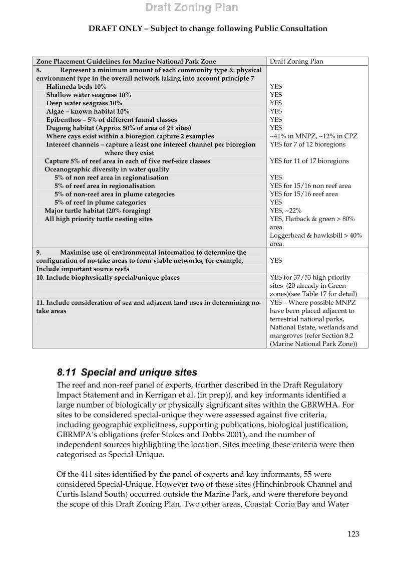
DRAFT ONLY – Subject to change following Public Consultation
123
Zone Placement Guidelines for Marine National Park Zone Draft Zoning Plan 8. Represent a minimum amount of each community type & physical environment type in the overall network taking into account principle 7 Halimeda beds 10% Shallow water seagrass 10% Deep water seagrass 10% Algae – known habitat 10% Epibenthos – 5% of different faunal classes Dugong habitat (Approx 50% of area of 29 sites) Where cays exist within a bioregion capture 2 examples Intereef channels – capture a least one intereef channel per bioregion where they exist Capture 5% of reef area in each of five reef-size classes Oceanographic diversity in water quality 5% of non reef area in regionalisation 5% of reef area in regionalisation 5% of non-reef area in plume categories 5% of reef in plume categories Major turtle habitat (20% foraging) All high priority turtle nesting sites
YES YES YES YES YES YES ~41% in MNPZ, ~12% in CPZ YES for 7 of 12 bioregions YES for 11 of 17 bioregions YES YES for 15/16 non reef area YES for 15/16 reef area YES YES, ~22% YES, Flatback & green > 80% area. Loggerhead & hawksbill > 40% area.
9. Maximise use of environmental information to determine the configuration of no-take areas to form viable networks, for example, Include important source reefs
YES
10. Include biophysically special/unique places
YES for 37/53 high priority sites (20 already in Green zones)(see Table 17 for detail)
11. Include consideration of sea and adjacent land uses in determining no-take areas
YES – Where possible MNPZ have been placed adjacent to terrestrial national parks, National Estate, wetlands and mangroves (refer Section 8.2 (Marine National Park Zone))
8.11 Special and unique sites The reef and non-reef panel of experts, (further described in the Draft Regulatory Impact Statement and in Kerrigan et al. (in prep)), and key informants identified a large number of biologically or physically significant sites within the GBRWHA. For sites to be considered special-unique they were assessed against five criteria, including geographic explicitness, supporting publications, biological justification, GBRMPA’s obligations (refer Stokes and Dobbs 2001), and the number of independent sources highlighting the location. Sites meeting these criteria were then categorised as Special-Unique. Of the 411 sites identified by the panel of experts and key informants, 55 were considered Special-Unique. However two of these sites (Hinchinbrook Channel and Curtis Island South) occurred outside the Marine Park, and were therefore beyond the scope of this Draft Zoning Plan. Two other areas, Coastal: Corio Bay and Water

DRAFT ONLY – Subject to change following Public Consultation
124
Park Point and Curtis Island North, were mostly out of the Marine Park. An assessment about how to best protect the remaining 53 special and unique sites was undertaken. Although the SSC broadly recommended that all the sites should, as far as possible, be included in MNPZ, an analysis of each site and its values indicated that zoning other than MNPZ could, in many instances, provide adequate protection. For other sites zoning would not necessarily be the best method of protecting the biological values, and other management tools such as plans of management, Regulations or permit conditions would be more appropriate. As such, 43 have been partly or wholly included in MNPZs, although 20 of these sites were in MNPZ or PZ through previous Zoning Plans (an additional 12 were partly in MNPZ or PZ). Table 16 lists the special and unique sites, a description of each and the proposed draft zoning.
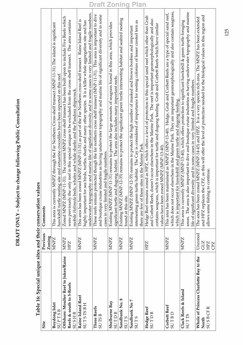
DR
AFT
ON
LY
– S
ub
ject
to c
han
ge f
ollo
win
g P
ub
lic
Con
sult
atio
n
12
5
Tab
le 1
6: S
pec
ial u
niq
ue
site
s an
d th
eir
con
serv
atio
n v
alu
es
Sit
e P
revi
ous
Zon
ing
Com
men
ts
Boy
don
g Is
let
SU P
T S
B
MN
PZ
Thi
s ar
ea is
cur
rent
ly M
NPZ
thro
ugh
the
Far
Nor
ther
n C
ross
-she
lf tr
anse
ct (M
NP-
11-3
1) T
he is
land
is s
igni
fica
nt
haw
ksbi
ll tu
rtle
nes
ting
sit
e an
d es
tuar
ine
croc
odile
s ha
ve b
een
repo
rted
on
this
ree
f.
Off
shor
e: M
oult
er R
eef
to J
uk
es/R
ain
e R
eefs
& s
outh
to 5
-Ree
fs
SU S
H B
MN
PZ
HPZ
Z
oned
MN
PZ (M
NP-
11-3
1).
The
cur
rent
MN
PZ c
ross
she
lf tr
anse
ct h
as b
een
built
upo
n to
incl
ude
Five
Ree
fs w
hich
w
ere
prev
ious
ly th
e on
ly r
eef i
n th
is s
peci
al u
niqu
e to
be
excl
uded
from
the
cros
s sh
elf t
rans
ect.
The
are
a co
ntai
ns
mob
ile H
alim
eda
beds
, wha
les
and
wha
le s
hark
s an
d th
e Pa
ndor
a sh
ipw
reck
. R
ain
e Is
lan
d R
eef
SU
T S
TS
B H
M
NPZ
T
his
area
has
bee
n zo
ned
MN
PZ (M
NP-
11-3
1) a
s pa
rt o
f the
Far
Nor
ther
n cr
oss-
shel
f tra
nsec
t. R
aine
Isla
nd R
eef i
s hi
ghly
impo
rtan
t for
sea
bir
ds,
turt
les,
sha
rks
and
man
y ot
her
spec
ies.
It i
s a
kille
r w
hale
agg
rega
tion
sit
e an
d h
as
und
erw
ater
topo
grap
hy a
nd m
arin
e lif
e of
sig
nifi
cant
div
ersi
ty a
nd in
som
e ca
ses
in v
ery
limit
ed a
nd fr
agile
num
bers
. T
hre
e R
eefs
SU
TS
B
MN
PZ
The
se r
eefs
rem
ain
prot
ecte
d th
ough
the
far
nort
hern
cro
ss s
helf
tran
sect
(MN
P-11
-31)
. T
his
area
is im
port
ant t
o d
ive
and
bou
tiqu
e cr
uise
indu
stri
es a
s ha
ving
und
erw
ater
topo
grap
hy a
nd m
arin
e lif
e of
sig
nifi
cant
div
ersi
ty a
nd in
som
e ca
ses
in v
ery
limit
ed a
nd fr
agile
num
bers
. S
hel
bu
rne
Bay
SU
T D
B
MN
PZ
Exis
ting
MN
PZ (M
NP-
11-3
1) r
emai
ns to
pro
tect
the
larg
e am
ount
s of
sea
gras
s fo
und
in th
is a
rea,
whi
ch p
rovi
des
si
gnif
ican
t tur
tle
and
dugo
ng h
abit
at.
The
are
a al
so in
clud
es m
any
impo
rtan
t ree
fs.
San
db
ank
No.
8
SU T
S
MN
PZ
Exi
stin
g M
NPZ
(MN
P-12
-35)
rem
ains
to p
rote
ct th
e si
gnif
ican
t gre
en tu
rtle
inte
rnes
ting
hab
itat
and
sea
bird
nes
ting
fo
und
at th
is s
ite.
S
and
ban
k N
o 7
SU T
S
MN
PZ
Exis
ting
MN
PZ (M
NP-
12-3
5) r
emai
ns to
pro
tect
the
high
num
ber
of m
aske
d an
d b
row
n bo
obie
s an
d im
port
ant
inte
rnes
ting
gre
en tu
rtle
hab
itat
. T
he C
ay is
con
sid
ered
of i
mpo
rtan
ce fo
r ne
stin
g co
loni
es o
f les
ser
cres
ted
tern
as
ther
e ar
e fe
w o
f the
se s
ites
in th
e M
arin
e Pa
rk.
H
edge
Ree
f
SU T
D B
H
PZ
Hed
ge R
eef r
emai
ns z
oned
as
HPZ
, whi
ch o
ffer
s a
leve
l of p
rote
ctio
n to
this
spe
cial
san
d r
eef w
hich
oth
er th
an G
rub
and
Cor
bett
Ree
fs, d
oesn
’t oc
cur
else
whe
re in
the
Mar
ine
Park
. T
he r
eef i
s im
port
ant g
eom
orph
olog
ical
ly a
nd a
lso
cont
ains
sea
gras
s, w
hich
is im
port
ant f
or tu
rtle
and
dug
ong
feed
ing.
Gru
b an
d C
orbe
tt R
eefs
whi
ch h
ave
sim
ilar
valu
es h
ave
been
zon
ed M
NPZ
(MN
P-13
-40)
. C
orb
ett R
eef
SU T
B D
M
NPZ
T
his
area
has
bee
n m
aint
aine
d a
s M
NPZ
(MN
P-13
-40)
. H
edge
, Gru
b an
d C
orbe
tt R
eefs
are
a ty
pe o
f spe
cial
san
d re
ef,
whi
ch d
oes
not o
ccur
els
ewhe
re in
the
Mar
ine
Park
. The
y ar
e im
port
ant g
eom
orph
olog
ical
ly a
nd a
lso
cont
ain
seag
rass
, w
hich
is im
port
ant f
or h
awks
bill
and
gree
n tu
rtle
and
dug
ong
feed
ing.
C
lack
Ree
fs &
Isl
and
SU
T T
S M
NPZ
Thi
s ar
ea is
cur
rent
ly M
NPZ
(MN
P-13
-40)
, whi
ch o
ffer
s pr
otec
tion
to s
igni
fica
nt h
awks
bill
& g
reen
turt
le fo
ragi
ng
area
s. T
he a
rea
is a
lso
impo
rtan
t to
div
e an
d bo
utiq
ue c
ruis
e in
dust
ries
as
havi
ng u
nder
wat
er to
pogr
aphy
and
mar
ine
life
of s
igni
fica
nt d
iver
sity
and
in s
ome
case
s in
ver
y lim
ited
and
frag
ile n
umbe
rs.
Wh
ole
of P
rin
cess
Ch
arlo
tte
Bay
to th
e N
orth
SU
S B
CF
R
Unz
oned
G
UZ
H
PZ
CPZ
The
are
a ha
s be
en z
oned
MN
PZ (M
NP-
14-4
3) a
nd H
PZ.
It is
a v
ery
spec
ies
rich
are
a. T
he M
NPZ
has
bee
n ex
tend
ed
and
HPZ
rep
lace
s th
e C
PZ, a
s th
is w
ill o
ffer
the
leve
l of p
rote
ctio
n ne
eded
for
the
biol
ogic
al v
alue
s in
this
reg
ion
and
al
low
s so
me
fish
ing
to c
ontin
ue.
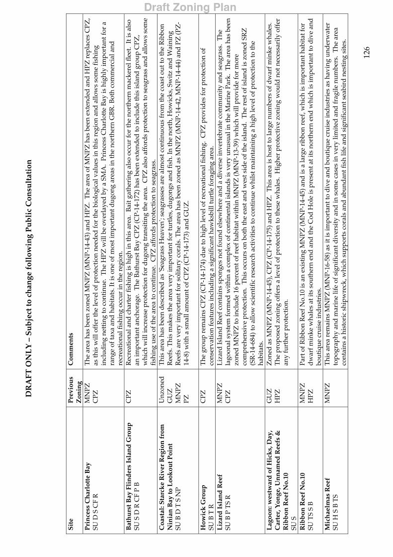
DR
AFT
ON
LY
– S
ub
ject
to c
han
ge f
ollo
win
g P
ub
lic
Con
sult
atio
n
12
6
S
ite
Pre
viou
s Z
onin
g C
omm
ents
Pri
nce
ss C
har
lott
e B
ay
SU D
S C
F R
M
NPZ
C
PZ
The
are
a ha
s be
en z
oned
MN
PZ (M
NP-
14-4
3) a
nd H
PZ.
The
are
a of
MN
PZ h
as b
een
exte
nded
and
HPZ
rep
lace
s C
PZ,
as th
is w
ill o
ffer
the
leve
l of p
rote
ctio
n ne
eded
for
the
biol
ogic
al v
alue
s in
this
reg
ion
and
allo
ws
som
e fi
shin
g in
clud
ing
nett
ing
to c
onti
nue.
The
HPZ
will
be
over
laye
d b
y a
SMA
. Pr
ince
ss C
harl
otte
Bay
is h
ighl
y im
port
ant f
or a
ra
nge
of ta
xa a
nd h
abit
ats.
It is
one
of m
ost i
mpo
rtan
t dug
ong
area
s in
the
nort
hern
GB
R. B
oth
com
mer
cial
and
re
crea
tion
al fi
shin
g oc
cur
in th
e re
gion
. B
ath
urs
t Bay
Fli
nd
ers
Isla
nd
Gro
up
SU
S D
R C
F P
B
CPZ
R
ecre
atio
nal a
nd c
hart
er fi
shin
g is
hig
h in
this
are
a. B
ait g
athe
ring
als
o oc
cur
for
the
nort
hern
mac
kere
l fle
et.
It is
als
o an
impo
rtan
t anc
hora
ge.
The
Bat
hurs
t Bay
CPZ
(CP-
14-1
72) h
as b
een
exte
nded
to in
clud
e th
is is
land
gro
up C
PZ,
whi
ch w
ill in
crea
se p
rote
ctio
n fo
r du
gong
tran
siti
ng th
e ar
ea.
CPZ
als
o af
ford
s pr
otec
tion
to s
eagr
ass
and
allo
ws
som
e fi
shin
g us
e of
the
area
to c
onti
nue.
CPZ
aff
ord
s pr
otec
tion
to s
eagr
ass.
C
oast
al: S
tarc
ke
Riv
er R
egio
n f
rom
N
inia
n B
ay to
Loo
kou
t Poi
nt
SU B
D T
S N
P
Unz
oned
G
UZ
M
NPZ
PZ
Thi
s ar
ea h
as b
een
des
crib
ed a
s 'S
eagr
ass
Hea
ven'
; sea
gras
ses
are
alm
ost c
onti
nuou
s fr
om th
e co
ast o
ut to
the
Rib
bon
Ree
fs. T
his
mak
es th
e ar
ea v
ery
impo
rtan
t for
turt
les,
dug
ongs
and
fish
. In
the
nort
h, H
owic
ks, S
witz
and
Wai
ning
R
eefs
are
ver
y im
port
ant f
or s
olit
ary
cora
ls. T
he a
rea
has
been
zon
ed a
s M
NPZ
(MN
P-14
-42,
MN
P-14
-44)
and
PZ
(PZ
-14
-8) w
ith
a sm
all a
mou
nt o
f CPZ
(CP-
14-1
73) a
nd G
UZ
.
How
ick
Gro
up
SU
B T
R
CPZ
T
he g
roup
rem
ains
CPZ
(CP-
14-1
74) d
ue to
hig
h le
vel o
f rec
reat
iona
l fis
hing
. C
PZ p
rovi
des
for
prot
ecti
on o
f co
nser
vati
on fe
atur
es in
clud
ing
a si
gnif
ican
t haw
ksbi
ll tu
rtle
fora
ging
are
a.
Liz
ard
Isl
and
Ree
f
SU B
P T
S R
M
NPZ
C
PZ
Liz
ard
Isla
nd R
eef c
onta
ins
spon
ges
not f
ound
els
ewhe
re a
nd a
div
erse
inve
rteb
rate
com
mun
ity
and
sea
gras
s. T
he
lago
onal
sys
tem
form
ed w
ithi
n a
com
plex
of c
ontin
enta
l isl
ands
is v
ery
unus
ual i
n th
e M
arin
e Pa
rk.
The
are
a ha
s be
en
zone
d M
NPZ
to in
clud
e 16
per
cent
of r
eef h
abit
at w
ithi
n M
NPZ
(MN
P-13
-39)
whi
ch w
ill p
rovi
de
for
mor
e co
mpr
ehen
sive
pro
tect
ion.
Thi
s oc
curs
on
both
the
east
and
wes
t sid
e of
the
isla
nd.
The
res
t of i
slan
d is
zon
ed S
RZ
(S
R-1
4-68
4) to
allo
w s
cien
tific
res
earc
h ac
tivi
ties
to c
onti
nue
whi
lst m
aint
aini
ng a
hig
h le
vel o
f pro
tect
ion
to th
e ha
bita
ts.
Lag
oon
: wes
twar
d o
f H
ick
s, D
ay,
Car
ter,
Yon
ge, U
nn
amed
Ree
fs &
R
ibb
on R
eef
No.
10
SU S
GU
Z
HPZ
Z
oned
as
MN
PZ (M
NP-
14-4
5), C
PZ (C
P-14
-175
) and
HPZ
. T
his
area
is h
ost t
o la
rge
num
bers
of d
war
f min
ke w
hale
s.
The
pro
pose
d zo
ning
off
ers
a le
vel o
f pro
tect
ion
to th
ese
wha
les.
Hig
her
prot
ecti
ve z
onin
g w
ould
not
nec
essa
rily
off
er
any
furt
her
prot
ecti
on.
Rib
bon
Ree
f N
o.10
SU
TS
S B
M
NPZ
H
PZ
Part
of R
ibbo
n R
eef N
o.10
is a
n ex
isti
ng M
NPZ
(MN
P-14
-45)
and
is a
larg
e ri
bbon
ree
f, w
hich
is im
port
ant h
abit
at fo
r d
war
f min
ke w
hale
s at
its
sout
hern
end
and
the
Cod
Hol
e is
pre
sent
at i
ts n
orth
ern
end
whi
ch is
impo
rtan
t to
div
e an
d
bout
ique
cru
ise
ind
ustr
ies.
M
ich
aelm
as R
eef
SU
H S
B T
S M
NPZ
T
his
area
rem
ains
MN
PZ (M
NP-
16-5
8) a
s it
is im
port
ant t
o d
ive
and
bou
tiqu
e cr
uise
ind
ustr
ies
as h
avin
g un
der
wat
er
topo
grap
hy a
nd m
arin
e lif
e of
sig
nifi
cant
div
ersi
ty a
nd in
som
e ca
ses
in v
ery
limit
ed a
nd fr
agile
num
bers
. T
he a
rea
cont
ains
a h
isto
ric
ship
wre
ck, w
hich
sup
port
s co
rals
and
abu
ndan
t fis
h lif
e an
d s
igni
fica
nt s
eabi
rd n
esti
ng s
ites
.
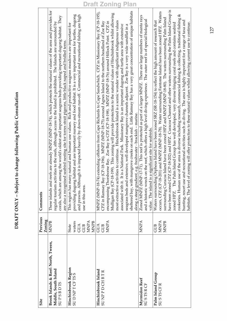
DR
AFT
ON
LY
– S
ub
ject
to c
han
ge f
ollo
win
g P
ub
lic
Con
sult
atio
n
12
7
S
ite
Pre
viou
s Z
onin
g C
omm
ents
Bro
ok I
slan
ds
& R
eef:
Nor
th, T
wee
n,
Mid
dle
, Sou
th I
slan
d
SU P
S B
D T
S
MN
PB
The
se is
land
s an
d re
efs
are
alre
ady
MN
PZ (M
NP-
18-7
4), w
hich
pro
tect
s th
e na
tura
l val
ues
of th
e ar
ea a
nd p
rovi
des
for
regu
lar
tour
ism
act
ivit
ies
to th
e re
efs,
alt
houg
h ac
cess
to th
e Is
land
is p
rohi
bite
d.
The
Isla
nds
are
surr
ound
ed b
y co
rals
, whi
ch a
re a
mon
g th
e w
orld
's o
ldes
t and
impo
rtan
t sea
gras
s be
ds
prov
idin
g im
port
ant d
ugon
g ha
bita
t. T
hey
are
also
a r
ecog
nise
d s
eabi
rd n
esti
ng s
ite
for
torr
es s
trai
t pig
eons
, lit
tle
blac
k na
ped
and
brid
led
tern
s.
Hin
chin
bro
ok R
egio
n
SU D
NP
T C
F T
S S
Stat
e w
ater
s G
UA
G
UB
M
NPA
M
NPB
Thi
s re
gion
has
man
y na
tura
l and
hum
an u
se v
alue
s. R
ich
and
pro
duc
tive
sea
gras
s m
ead
ows
are
impo
rtan
t for
pr
ovid
ing
dug
ong
habi
tat a
nd a
re im
port
ant n
urse
ry a
nd fo
od h
abit
at. I
t is
a ve
ry im
port
ant a
rea
for
turt
les,
dug
ong
and
pra
wns
. Alt
houg
h it
is im
pact
ed h
eavi
ly b
y d
own-
stre
am r
un-o
ff.
Com
mer
cial
and
rec
reat
iona
l fis
hing
are
hig
h us
e in
this
are
a.
Hin
chin
bro
ok I
slan
d
SU N
P P
D C
H B
T R
G
UA
G
UB
M
NPA
MN
PZ (M
NP-
18-7
4) e
xten
din
g of
fsho
re fr
om C
ape
Ric
hard
s to
Cap
e Sa
ndw
hich
. C
PZ in
Mis
sion
ary
Bay
(CP-
18-1
95),
CPZ
in R
amsa
y B
ay (C
P-18
-196
). M
NPZ
(MN
P-18
-75)
aro
und
Agn
es Is
land
to th
e no
rthe
rn h
eadl
and
of Z
oe B
ay
enco
mpa
ssin
g T
hors
born
e B
ay.
Zoe
Bay
is C
PZ (C
P-18
-198
). M
NPZ
(MN
P-18
-76)
aro
und
Hill
ock
Poin
t. C
PZ in
M
ullig
an B
ay (C
P-18
-199
). T
his
zoni
ng w
ill p
rovi
de p
rote
ctio
n to
the
natu
ral v
alue
s of
Hin
chin
broo
k w
hils
t allo
win
g m
ost e
xtra
ctiv
e ac
tivi
ties
to c
onti
nue.
Hin
chin
broo
k Is
land
is a
sce
nic
won
der
wit
h si
gnif
ican
t ind
igen
ous
valu
es
asso
ciat
ed w
ith
it.
It is
a N
atio
nal P
ark.
Mis
sion
ary
Bay
is a
n im
port
ant d
ugon
g an
d tu
rtle
are
a w
ith
exte
nsiv
e se
agra
ss b
eds
and
exte
nsiv
e, w
ell d
evel
oped
man
grov
e ch
anne
ls a
djac
ent.
Zoe
Bay
is a
ver
y w
ide
sand
flat
in a
sh
elte
red
bay,
wit
h m
angr
ove
cree
ks o
n ea
ch e
nd.
Litt
le R
amsa
y Ba
y ha
s a
very
gre
at c
once
ntra
tion
of u
niqu
e ha
bita
ts
alon
g a
stee
p gr
adie
nt, e
.g. f
resh
wat
er -
brac
kish
– m
arin
e.
Myr
mid
on R
eef
SU S
TS
R C
F M
NPA
Z
oned
MN
PZ (M
NP-
17-7
1).
Thi
s re
ef is
pro
tect
ed a
s pa
rt o
f a la
rger
MN
PZ.
The
re a
re la
rge
num
bers
of m
anta
ray
s an
d a
his
tori
c w
reck
on
the
reef
, whi
ch o
ffer
s a
high
leve
l div
ing
expe
rien
ce.
The
out
er r
eef i
s of
spe
cial
bio
logi
cal
valu
e. T
he is
land
is a
sig
nifi
cant
sit
e fo
r se
abir
ds.
P
alm
Isl
and
Gro
up
SU
S T
S C
F R
G
UB
M
NPA
M
NPB
Wat
ers
surr
ound
ing
Orp
heus
Isla
nd h
ave
been
zon
ed S
RZ
(SR
-18-
154)
to r
efle
ct th
e hi
gh a
mou
nt o
f res
earc
h th
at
occu
rs, C
PZ (C
P-18
-201
) and
MN
PZ (M
NP-
18-7
8).
Wat
er s
urro
und
ing
Fant
ome
Isla
nd h
ave
been
zon
ed H
PZ.
Wat
ers
surr
ound
ing
Cur
acoa
Isla
nd h
ave
been
zon
ed H
PZ a
nd M
NPZ
(MN
P-18
-80)
. Th
e w
ater
s su
rrou
ndin
g Pa
lm Is
land
ha
ve b
een
zone
d C
PZ (C
P-18
-202
) and
HPZ
. C
urac
oa C
hann
el a
nd o
ther
wat
ers
surr
ound
ing
the
Palm
Isla
nd G
roup
is
zone
d H
PZ.
The
Pal
m Is
land
Gro
up h
as w
ell d
evel
oped
, ver
y d
iver
se fr
ingi
ng c
oral
ree
fs a
nd c
onta
ins
seab
ird
ro
oker
ies.
Hum
an u
se o
f the
are
a is
div
erse
incl
udin
g re
sear
ch, c
omm
erci
al fi
shin
g &
col
lect
ing,
trad
itio
nal f
ishi
ng &
hu
ntin
g, r
esor
t use
and
rec
reat
iona
l act
ivit
ies
such
as
div
ing.
The
are
a is
hig
hly
impo
rtan
t for
a r
ange
of t
axa
and
ha
bita
ts. T
he le
vel o
f zon
ing
will
off
er p
rote
ctio
n to
thes
e na
tura
l val
ues
whi
lst a
llow
ing
curr
ent u
se to
con
tinue
.
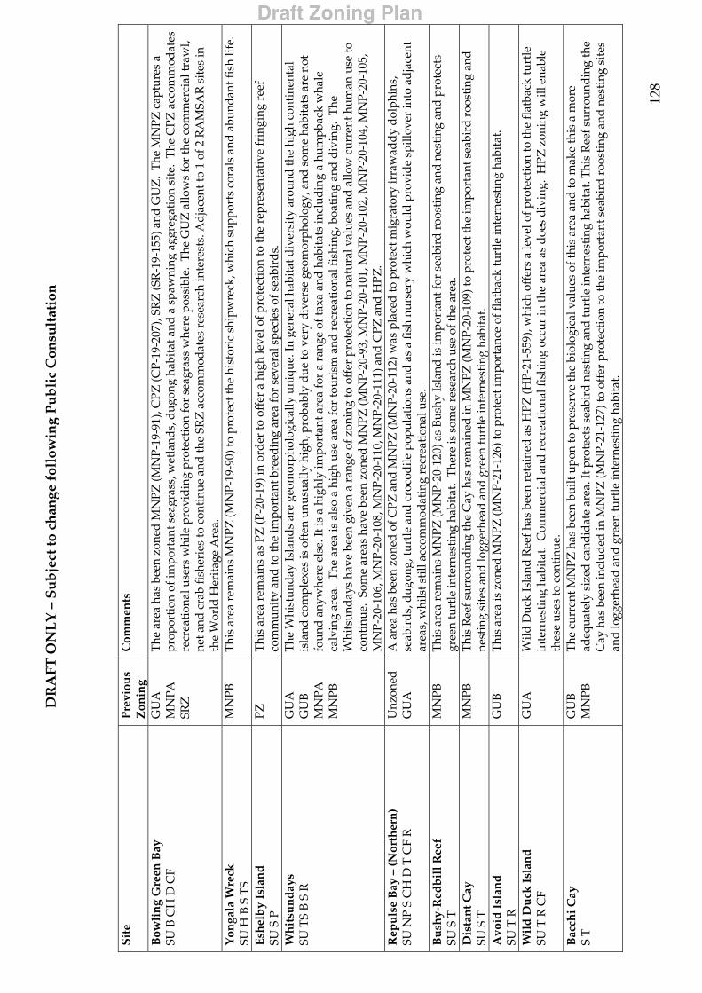
DR
AFT
ON
LY
– S
ub
ject
to c
han
ge f
ollo
win
g P
ub
lic
Con
sult
atio
n
12
8
S
ite
Pre
viou
s Z
onin
g C
omm
ents
Bow
lin
g G
reen
Bay
SU
B C
H D
CF
GU
A
MN
PA
SRZ
The
are
a ha
s be
en z
oned
MN
PZ (M
NP-
19-9
1), C
PZ (C
P-19
-207
), SR
Z (S
R-1
9-15
5) a
nd G
UZ
. T
he M
NPZ
cap
ture
s a
prop
orti
on o
f im
port
ant s
eagr
ass,
wet
land
s, d
ugon
g ha
bita
t and
a s
paw
ning
agg
rega
tion
sit
e. T
he C
PZ a
ccom
mod
ates
re
crea
tion
al u
sers
whi
le p
rovi
din
g pr
otec
tion
for
seag
rass
whe
re p
ossi
ble.
The
GU
Z a
llow
s fo
r th
e co
mm
erci
al tr
awl,
net a
nd c
rab
fish
erie
s to
con
tinu
e an
d th
e SR
Z a
ccom
mod
ates
res
earc
h in
tere
sts.
Ad
jace
nt to
1 o
f 2 R
AM
SAR
sit
es in
th
e W
orld
Her
itag
e A
rea.
Y
onga
la W
reck
SU
H B
S T
S M
NPB
T
his
area
rem
ains
MN
PZ (M
NP-
19-9
0) to
pro
tect
the
hist
oric
shi
pwre
ck, w
hich
sup
port
s co
rals
and
abu
ndan
t fis
h lif
e.
Esh
elb
y Is
lan
d
SU S
P
PZ
Thi
s ar
ea r
emai
ns a
s PZ
(P-2
0-19
) in
ord
er to
off
er a
hig
h le
vel o
f pro
tect
ion
to th
e re
pres
enta
tive
frin
ging
ree
f co
mm
unit
y an
d to
the
impo
rtan
t bre
edin
g ar
ea fo
r se
vera
l spe
cies
of s
eabi
rds.
W
hit
sun
day
s
SU T
S B
S R
G
UA
G
UB
M
NPA
M
NPB
The
Whi
stun
day
Isla
nds
are
geom
orph
olog
ical
ly u
niqu
e. In
gen
eral
hab
itat d
iver
sity
aro
und
the
high
con
tine
ntal
is
land
com
plex
es is
oft
en u
nusu
ally
hig
h, p
roba
bly
due
to v
ery
dive
rse
geom
orph
olog
y, a
nd s
ome
habi
tats
are
not
fo
und
anyw
here
els
e. It
is a
hig
hly
impo
rtan
t are
a fo
r a
rang
e of
taxa
and
hab
itat
s in
clud
ing
a hu
mpb
ack
wha
le
calv
ing
area
. T
he a
rea
is a
lso
a hi
gh u
se a
rea
for
tour
ism
and
rec
reat
iona
l fis
hing
, boa
ting
and
div
ing.
The
W
hits
und
ays
have
bee
n gi
ven
a ra
nge
of z
onin
g to
off
er p
rote
ctio
n to
nat
ural
val
ues
and
allo
w c
urre
nt h
uman
use
to
cont
inue
. So
me
area
s ha
ve b
een
zone
d M
NPZ
(MN
P-20
-93,
MN
P-20
-101
, MN
P-20
-102
, MN
P-20
-104
, MN
P-20
-105
, M
NP-
20-1
06, M
NP-
20-1
08, M
NP-
20-1
10, M
NP-
20-1
11) a
nd C
PZ a
nd H
PZ.
Rep
uls
e B
ay –
(Nor
ther
n)
SU N
P S
CH
D T
CF
R
Unz
oned
G
UA
A
are
a ha
s be
en z
oned
of C
PZ a
nd M
NPZ
(MN
P-20
-112
) was
pla
ced
to p
rote
ct m
igra
tory
irra
wad
dy
dol
phin
s,
seab
ird
s, d
ugon
g, tu
rtle
and
cro
cod
ile p
opul
atio
ns a
nd a
s a
fish
nur
sery
whi
ch w
ould
pro
vide
spi
llove
r in
to a
djac
ent
area
s, w
hils
t sti
ll ac
com
mod
atin
g re
crea
tion
al u
se.
Bu
shy-
Red
bil
l Ree
f
SU S
T
MN
PB
Thi
s ar
ea r
emai
ns M
NPZ
(MN
P-20
-120
) as
Bush
y Is
land
is im
port
ant f
or s
eabi
rd r
oost
ing
and
nes
ting
and
pro
tect
s gr
een
turt
le in
tern
esti
ng h
abit
at.
The
re is
som
e re
sear
ch u
se o
f the
are
a.
Dis
tan
t Cay
SU
S T
M
NPB
T
his
Ree
f sur
roun
din
g th
e C
ay h
as r
emai
ned
in M
NPZ
(MN
P-20
-109
) to
prot
ect t
he im
port
ant s
eabi
rd r
oost
ing
and
ne
stin
g si
tes
and
logg
erhe
ad a
nd g
reen
turt
le in
tern
esti
ng h
abit
at.
Avo
id I
slan
d
SU T
R
GU
B T
his
area
is z
oned
MN
PZ (M
NP-
21-1
26) t
o pr
otec
t im
port
ance
of f
latb
ack
turt
le in
tern
esti
ng h
abit
at.
W
ild
Du
ck I
slan
d
SU T
R C
F G
UA
W
ild D
uck
Isla
nd R
eef h
as b
een
reta
ined
as
HPZ
(HP-
21-5
59),
whi
ch o
ffer
s a
leve
l of p
rote
ctio
n to
the
flat
back
turt
le
inte
rnes
ting
hab
itat
. C
omm
erci
al a
nd r
ecre
atio
nal f
ishi
ng o
ccur
in th
e ar
ea a
s d
oes
divi
ng.
HPZ
zon
ing
will
ena
ble
thes
e us
es to
con
tinu
e.
Bac
chi C
ay
S T
G
UB
M
NPB
T
he c
urre
nt M
NPZ
has
bee
n bu
ilt u
pon
to p
rese
rve
the
biol
ogic
al v
alue
s of
this
are
a an
d to
mak
e th
is a
mor
e ad
equa
tely
siz
ed c
andi
date
are
a. It
pro
tect
s se
abir
d ne
stin
g an
d tu
rtle
inte
rnes
ting
hab
itat
. Thi
s R
eef s
urro
undi
ng th
e C
ay h
as b
een
incl
uded
in M
NPZ
(MN
P-21
-127
) to
offe
r pr
otec
tion
to th
e im
port
ant s
eabi
rd r
oost
ing
and
nest
ing
site
s an
d lo
gger
head
and
gre
en tu
rtle
inte
rnes
ting
hab
itat
.
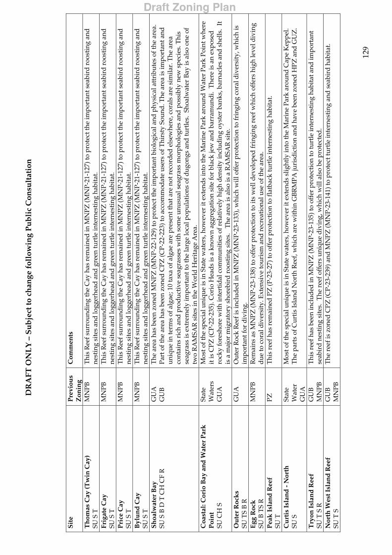
DR
AFT
ON
LY
– S
ub
ject
to c
han
ge f
ollo
win
g P
ub
lic
Con
sult
atio
n
12
9
S
ite
Pre
viou
s Z
onin
g C
omm
ents
Th
omas
Cay
(Tw
in C
ay)
SU S
T
MN
PB
Thi
s R
eef s
urro
und
ing
the
Cay
has
rem
aine
d in
MN
PZ (M
NP-
21-1
27) t
o pr
otec
t the
impo
rtan
t sea
bird
roo
stin
g an
d
nest
ing
site
s an
d lo
gger
head
and
gre
en tu
rtle
inte
rnes
ting
hab
itat
. Fr
igat
e C
ay
SU S
T
MN
PB
Thi
s R
eef s
urro
und
ing
the
Cay
has
rem
aine
d in
MN
PZ (M
NP-
21-1
27) t
o pr
otec
t the
impo
rtan
t sea
bird
roo
stin
g an
d
nest
ing
site
s an
d lo
gger
head
and
gre
en tu
rtle
inte
rnes
ting
hab
itat
. P
rice
Cay
SU
S T
M
NPB
T
his
Ree
f sur
roun
din
g th
e C
ay h
as r
emai
ned
in M
NPZ
(MN
P-21
-127
) to
prot
ect t
he im
port
ant s
eabi
rd r
oost
ing
and
ne
stin
g si
tes
and
logg
erhe
ad a
nd g
reen
turt
le in
tern
esti
ng h
abit
at.
Byl
un
d C
ay
SU S
T
MN
PB
Thi
s R
eef s
urro
und
ing
the
Cay
has
rem
aine
d in
MN
PZ (M
NP-
21-1
27) t
o pr
otec
t the
impo
rtan
t sea
bird
roo
stin
g an
d
nest
ing
site
s an
d lo
gger
head
and
gre
en tu
rtle
inte
rnes
ting
hab
itat
. S
hoa
lwat
er B
ay
SU S
B D
T C
H C
F R
G
UA
G
UB
T
he a
rea
has
been
zon
ed M
NPZ
(MN
P-22
-129
) to
prot
ect t
he im
port
ant b
iolo
gica
l and
phy
sica
l att
ribu
tes
of th
e ar
ea.
Part
of t
he a
rea
has
been
zon
ed C
PZ (C
P-22
-223
) to
acco
mm
odat
e us
ers
of T
hirs
ty S
ound
. The
are
a is
impo
rtan
t and
un
ique
in te
rms
of a
lgae
; 10
taxa
of a
lgae
are
pre
sent
that
are
not
rec
ord
ed e
lsew
here
, cor
als
are
sim
ilar.
The
are
a co
ntai
ns r
ich
and
pro
duct
ive
seag
rass
es w
ith
som
e un
usua
l sea
gras
s m
orph
olog
ies
and
poss
ibly
new
spe
cies
. Thi
s se
agra
ss is
ext
rem
ely
impo
rtan
t to
the
larg
e lo
cal p
opul
atio
ns o
f dug
ongs
and
turt
les.
Sho
alw
ater
Bay
is a
lso
one
of
two
RA
MSA
R s
ites
in th
e W
orld
Her
itag
e A
rea.
C
oast
al: C
orio
Bay
an
d W
ater
Par
k
Poi
nt
SU C
H S
Stat
e W
ater
s G
UA
Mos
t of t
he s
peci
al u
niqu
e is
in S
tate
wat
ers,
how
ever
it e
xten
ds
into
the
Mar
ine
Park
aro
und
Wat
er P
ark
Poin
t whe
re
it is
CPZ
(CP-
22-2
35).
Cor
io H
ead
s is
a k
now
n ag
greg
atio
n si
te fo
r bl
ack
jew
and
bar
ram
undi
. T
here
is a
n ex
pose
d
rock
y fo
resh
ore
wit
h in
tert
idal
com
mun
itie
s of
rel
ativ
ely
high
den
sity
incl
udin
g oy
ster
ban
ks, b
arna
cles
and
she
lls.
It
is a
maj
or m
igra
tory
sho
rebi
rd r
oost
ing
site
s.
The
are
a is
als
o is
a R
AM
SAR
sit
e.
Ou
ter
Roc
ks
SU
TS
B R
G
UA
O
uter
Roc
k R
eef i
s in
clud
ed in
MN
PZ (M
NP-
23-1
33),
whi
ch w
ill o
ffer
pro
tect
ion
to fr
ingi
ng c
oral
div
ersi
ty, w
hich
is
impo
rtan
t for
div
ing.
E
gg R
ock
SU
B T
S R
M
NPB
R
emai
ns a
s M
NPZ
(MN
P-23
-138
) to
offe
r pr
otec
tion
to it
s w
ell d
evel
oped
frin
ging
ree
f whi
ch o
ffer
s hi
gh le
vel d
ivin
g d
ue to
cor
al d
iver
sity
. Ext
ensi
ve to
uris
m a
nd r
ecre
atio
nal u
se o
f the
are
a.
Pea
k I
slan
d R
eef
SU
T
PZ
Thi
s re
ef h
as r
emai
ned
PZ
(P-2
3-27
) to
offe
r pr
otec
tion
to fl
atba
ck tu
rtle
inte
rnes
ting
hab
itat
.
Cu
rtis
Isl
and
- N
orth
SU
S
Stat
e W
ater
G
UA
Mos
t of t
he s
peci
al u
niqu
e is
in S
tate
wat
ers,
how
ever
it e
xten
ds
slig
htly
into
the
Mar
ine
Park
aro
und
Cap
e K
eppe
l. T
he p
arts
of C
urti
s Is
land
Nor
th R
eef,
whi
ch a
re w
ithi
n G
BRM
PA ju
risd
icti
on a
nd h
ave
been
zon
ed H
PZ a
nd G
UZ
.
Try
on I
slan
d R
eef
SU
T S
R
GU
B
MN
PB
Thi
s re
ef h
as b
een
incl
uded
in M
NPZ
(MN
P-23
-135
) to
offe
r pr
otec
tion
to tu
rtle
inte
rnes
ting
hab
itat
and
impo
rtan
t se
abir
d n
esti
ng s
ites
. T
he r
eef o
ffer
s un
ique
div
ing,
whi
ch w
ill a
lso
be p
rote
cted
. N
orth
Wes
t Isl
and
Ree
f
SU T
S
GU
B
MN
PB
The
ree
f is
zone
d C
PZ (C
P-23
-239
) and
MN
PZ (M
NP-
23-1
41) t
o pr
otec
t tur
tle
inte
rnes
ting
and
sea
bird
hab
itat
.

DR
AFT
ON
LY
– S
ub
ject
to c
han
ge f
ollo
win
g P
ub
lic
Con
sult
atio
n
13
0
S
ite
Pre
viou
s Z
onin
g C
omm
ents
Wil
son
Isl
and
Ree
f
SU T
S R
G
UB
T
his
reef
has
bee
n zo
ned
CPZ
(CP-
23-2
39) t
o of
fer
prot
ecti
on to
turt
le fo
ragi
ng h
abit
at a
nd im
port
ant s
eabi
rd n
esti
ng
site
s. T
he r
eef i
s co
nnec
ted
to W
reck
Isla
nd R
eef’
s un
der
wat
er r
eef s
yste
ms.
CPZ
allo
ws
som
e cu
rren
t fis
hing
use
to
cont
inue
. W
reck
Isl
and
Ree
f SU
T S
PZ
T
his
reef
rem
ains
as
PZ (P
Z-2
3-26
) and
now
is s
urro
und
ed b
y M
NPZ
(MN
P-23
-142
) buf
fer.
Thi
s w
ill o
ffer
a h
igh
leve
l of
pro
tect
ion
to g
reen
and
logg
erhe
ad tu
rtle
inte
rnes
ting
hab
itat
and
sea
bird
sit
es.
Her
on I
slan
d R
eef
SU T
S B
TS
R C
F P
H
MN
PA
MN
PB
The
are
a ha
s be
en z
oned
MN
PZ (M
NP-
23-1
44) t
o in
corp
orat
e th
e w
este
rn s
ide
of th
e re
ef a
nd th
e la
goon
al a
rea
into
a
larg
er M
NPZ
pro
vid
ing
mor
e ad
equa
te p
rote
ctio
n. T
he C
PZ (C
P-23
-239
) pro
vide
s fo
r re
crea
tion
al, c
hart
er, a
ncho
rage
an
d r
esor
t tou
rism
to c
onti
nue.
The
SR
Z (S
R-2
3-15
6) p
rovi
des
for
rese
arch
use
and
res
earc
h m
onit
orin
g. T
he p
ropo
sed
zo
ning
con
tinu
es o
ffer
ing
a hi
gh d
egre
e of
pro
tect
ion
to tu
rtle
fora
ging
and
inte
rnes
ting
an
d se
abir
d ha
bita
t. M
asth
ead
Isl
and
Ree
f SU
T S
G
UB
M
NPB
T
he r
eef i
s zo
ned
MN
PZ (M
NP-
23-1
44) t
o pr
otec
t tur
tle
inte
rnes
ting
and
sea
bird
hab
itat
.
Cap
rico
rn B
un
ker
Gro
up
SU
S T
TS
R C
F G
UB
M
NPA
SR
Z
MN
PB
PZ
Thi
s gr
oup
has
been
zon
ed a
s H
PZ, C
PZ, S
RZ
, MN
PZ a
nd P
Z to
off
er a
ppro
pria
te le
vel o
f pro
tect
ion
to s
peci
al a
nd
uniq
ue v
alue
s w
hile
mai
ntai
ning
a le
vel o
f ext
ract
ive
acce
ss to
this
hig
hly
used
and
impo
rtan
t are
a, e
spec
ially
for
com
mer
cial
line
fish
ing
and
col
lect
ing.
Spe
cial
and
Uni
que
valu
es in
clud
e th
e hi
ghly
impo
rtan
t ran
ge o
f tax
a an
d
habi
tats
. T
here
are
fish
pop
ulat
ions
that
are
gen
etic
ally
end
emic
to th
e ar
ea.
Betw
een
Wis
tari
and
Her
on R
eefs
ther
e ar
e d
eep
chan
nels
con
tain
ing
spec
ies
that
are
cha
ract
eris
tic
of th
e Fa
r N
orth
aro
und
Liz
ard
Isla
nd, t
hese
spe
cies
are
not
ap
pare
nt a
nyw
here
els
e in
sou
ther
n re
gion
, pos
sibl
y si
gnif
ying
uni
que
recr
uitm
ent p
atte
rns
to th
is r
egio
n. T
he a
rea
also
con
tain
s cr
itic
al in
tern
esti
ng h
abita
t for
gre
en a
nd lo
gger
head
turt
les
and
crit
ical
fora
ging
hab
itat
for
gree
n,
logg
erhe
ad a
nd h
awks
bill
turt
les.
Sig
nifi
cant
bir
d n
esti
ng s
ites
are
pre
sent
alo
ng w
ith
a hi
gh a
mou
nt o
f tou
rism
.
Lad
y E
llio
tt I
slan
d R
eef
SU T
S R
S
MN
PA
MN
PB
The
cur
rent
MN
PZ (M
NP-
23-1
46) h
as b
een
built
upo
n in
to a
larg
er z
one,
whi
ch in
clud
es L
ady
Elli
ot Is
land
Ree
f. T
his
will
off
er p
rote
ctio
n to
the
sout
hern
mos
t ree
f in
the
GBR
Reg
ion
and
to it
s si
gnif
ican
t man
ta r
ay h
abit
at a
nd a
ssoc
iate
d d
ivin
g op
port
unit
ies.
C
oast
al: R
oun
d H
ill H
ead
to W
reck
R
ock
SU
T
GU
A
Thi
s ar
ea h
as b
een
zone
d w
ith
a sm
all a
mou
nt o
f GU
Z a
nd m
ostl
y M
NPZ
(MN
P-24
-148
) to
prot
ect t
he lo
gger
head
and
le
athe
rbac
k tu
rtle
inte
rnes
ting
hab
itat
.

131
9 References General references Environment Protection and Biodiversity Act 1999 Fisheries Regulations 1995 (Queensland) Great Barrier Reef Marine Park Act 1975 Great Barrier Reef Marine Park Regulations 1983 Great Barrier Reef Marine Park Authority, 1985. Great Barrier Reef Marine Park Zoning
the Central Section, Great Barrier Reef Marine Park Authority, Townsville. Great Barrier Reef Marine Park Authority, 1985. Information Summary, Central Section
of the Great Barrier Reef Marine Park, Great Barrier Reef Marine Park Authority, Townsville.
Great Barrier Reef Marine Park Authority, 1986. Great Barrier Reef Marine Park Southern Sections (Capricorn and Capricornia Sections) Information Summary, Great Barrier Reef Marine Park Authority, Townsville.
Great Barrier Reef Marine Park Authority, 1985. Great Barrier Reef Marine Park Central Section Zoning Plan for Public Review, Great Barrier Reef Marine Park Authority, Townsville.
Great Barrier Reef Marine Park Authority, 1987. Great Barrier Reef Marine Park Central Section Zoning Plan, Great Barrier Reef Marine Park Authority, Townsville.
Great Barrier Reef Marine Park Authority, 1987. Great Barrier Reef Marine Park Mackay/Capricorn Section Zoning Plan, Great Barrier Reef Marine Park Authority, Townsville.
Great Barrier Reef Marine Park Authority, 1988. Great Barrier Reef Marine Park Cairns Zoning Plan Review: Issues, Great Barrier Reef Marine Park Authority, Townsville.
Great Barrier Reef Marine Park Authority, 1989. Great Barrier Reef Marine Park, Zoning the Cairns Section, Summary of Public Comments and Resource Information, Great Barrier Reef Marine Park Authority, Townsville.
Great Barrier Reef Marine Park Authority, 1992. Great Barrier Reef Marine Park Cairns Section Zoning Plan, Great Barrier Reef Marine Park Authority, Townsville.
Great Barrier Reef Marine Park Authority, 1994. A 25 Year Strategic Plan for the Great Barrier Reef World Heritage Area. Great Barrier Reef Marine Park Authority, Townsville, Queensland, Australia.
Great Barrier Reef Marine Park Authority, 2002. Cairns Area Plan of Management (Reprinted as in force June 2002 includes Amendment No. 1 2002). Great Barrier Reef Marine Park Authority, Townsville.
Great Barrier Reef Marine Park Authority, 2002. Great Barrier Reef Marine Park Far Northern Section Basis for Zoning Decisions, Great Barrier Reef Marine Park Authority, Townsville.
Great Barrier Reef Marine Park Authority, 2002. Great Barrier Reef Marine Park Far Northern Section Zoning Plan, Great Barrier Reef Marine Park Authority, Townsville.
Great Barrier Reef Marine Park Authority, 2002. Great Barrier Reef Marine Park Gumoo Woojabuddee Section Basis for Zoning Decisions, Great Barrier Reef Marine Park Authority, Townsville.
132
Great Barrier Reef Marine Park Authority, 2002. Great Barrier Reef Marine Park Gumoo Woojabuddee Section Zoning Plan, Great Barrier Reef Marine Park Authority, Townsville.
Great Barrier Reef Marine Park Authority, 2002. Whitsundays Plan of Management (Reprinted as in force June 2002 includes Amendment No. 1 2002). Great Barrier Reef Marine Park Authority, Townsville.
Marine Parks, 1997. Marine Parks of Cape York, Proposed Zoning and Management for the Far Northern Section of the Great Barrier Reef Marin Park and Zoning of the Proposed Cape York Marine Park, Great Barrier Reef Marine Park Authority and Department of Environment, Townsville.
Marine Parks, 1999. Marine Parks of the Byfield Coast and Port Clinton, Proposed Zoning for the Gumoo Woojabuddee Section and zoning of the proposed Gumoo Woojabuddee Marine Park, Great Barrier Reef Marine Park Authority and Queensland Parks and Wildlife Service, Townsville.
Queensland Fisheries Service, 1999. Fisheries (East Coast Trawl) Management Plan 1999, Department of Primary Industries, Brisbane.
Queensland Fisheries Service, 2002. Coral Reef Fin Fish Fishery Consultation Paper, Queensland Department of Primary Industries, Brisbane.
References for symbol attributes
Attribute Reference Turtles Chaloupka, M. 2001. Development of a population model for the southern Great Barrier
Reef green turtle stock, Phase 2 Final Report to GBRMPA, Townsville. Chaloupka, M. 2002. ‘Stochastic simulation modelling of southern Great Barrier
Reef green turtle population dynamics’, Ecological Modelling 148, 79-100. Dobbs, K. A., Miller, J. D., Limpus, C. J. & Landry, A. M., Jr. 1999. ‘Hawksbill
turtle, Eretmochelys imbricata, nesting at Milman Island, northern Great Barrier Reef, Australia’, Chelonian Conservation and Biology 3(2), 344-361.
Great Barrier Reef Marine Park Authority, 1994. A 25 Year Strategic Plan for the Great Barrier Reef World Heritage Area. Great Barrier Reef Marine Park Authority, Townsville, Queensland, Australia.
Limpus, C. J. 1980. ‘Observations of the hawksbill turtle, Eretmochelys imbricata, nesting in north-eastern Australia’, Herpetologica, 36(3), 265-71.
Limpus, C. J. 1973. ‘Loggerhead turtles (Caretta caretta) in Australia: food resources while nesting’, Herpetologica, 29, 42-5.
Limpus, C. J. & Miller, J. D. 2000. Final Report for Australian Hawksbill Turtle Population Dynamics Project. Unpublished report to the Japanese Bekko Association and the Queensland Parks and Wildlife Service, Queensland Parks and Wildlife Service, Brisbane.
Limpus, C. J., Miller, J. D., Limpus, D. J. and Hamann, M. 2000. ‘The Raine Island green turtle rookery: Y2K update’, in Proceedings of the 20th Annual Symposium on Sea Turtle Biology and Conservation, Mosier, A., Foley, A., Brost, B.
133
(Compliers), NOAA Technical Memorandum NMFS-SESFC-477. http://www.nmfs.noaa.gov/prot_res/readingrm/turtlesymp/20turtle.pdf.
Limpus, C. J., Miller, J. D., Parmenter, C. J., Reimer, D., McLachlan, N. & Webb, R. 1992. ‘Migration of green (Chelonia mydas) and loggerhead (Caretta caretta) turtles to and from eastern Australian rookeries’, Wildlife Research, 19, 347-358.
Limpus, C. J., Parmenter, C. J., Parker, R., & Ford, N. 1981. ‘The flatback turtle, Chelonia depressa, in Queensland: the Peak Island rookery’, Herpetofauna, 13(1), 14-8.
Limpus, C. J. & Reed, P. C. 1985. ‘The loggerhead turtle, Caretta caretta, in Queensland: observations on internesting behaviour’, Australian Wildlife Research, 12, 535-40.
Limpus, C. J. & Reimer, D. 1994. ‘The loggerhead turtle, Caretta caretta, in Queensland: a population in decline’, in Proceedings of the Australian Marine Turtle Conservation Workshop, Sea World Nara Resort, Gold Coast, 14 - 17 November 1990, R. James (compiler), Queensland Department of Environment & Australian Nature Conservation Agency, pp. 34-48.
Miller, J. D., 1994. ‘The hawksbill turtle, Eretmochelys imbricata: a perspective on the species’, in Proceedings of the Australian Marine Turtle Conservation Workshop, Sea World Nara Resort, Gold Coast, 14 - 17 November 1990, compiler R. James, Queensland Department of Environment & Australian Nature Conservation Agency, pp. 25-38.
Miller, J. D., Daly, T., Card, M. A. & Ludecke, J. 1995. Status of hawksbill turtles and other fauna and flora on northern Great Barrier Reef and central Torres Strait islands 1991, Queensland Department of Environment and Heritage and Greenpeace Australia Ltd, Townsville.
Miller, J. D., Dobbs, K. A., Mattocks, N., Limpus, C. J. & Landry, A. M., Jr., 1998. ‘Long-distance migrations by the hawksbill turtle, Eretmochelys imbricata, from north-eastern Australia’, Wildlife Research, 25, 89-95.
Parmenter, C. J. 1994. ‘Species review: the flatback turtle – Natator depressus’, in Proceedings of the Australian Marine Turtle Conservation Workshop, Sea World Nara Resort, Gold Coast, 14 - 17 November 1990, R. James (compiler), Queensland Department of Environment & Australian Nature Conservation Agency, pp. 60-62.
Slater, J., Limpus, C. J., Robins, J., Pantus, F. & Chaloupka, M. 1998. Risk Assessment of Sea Turtle Capture in the Queensland East Coast Otter Trawl Fishery, Final report prepared for TRAWLMAC, Queensland Parks and Wildlife Service, Brisbane.
Dugong (feeding, breeding, transit)
Dugong Protection Areas: Spatial data set interpreted by the Spatial Data Centre (GBRMPA) from gazetted descriptions in Queensland Fisheries Regulations 1995.
GBRMPA, 1994b, Turtle and Dugong Conservation Strategy for the Great Barrier Reef Marine Park Issues paper for public comment, GBRMPA, Townsville.
Marsh, H., De’ath, G., Gribble, N. and Lane, B., 2001. Shark control records hindcast serious decline in dugong numbers off the urban coast of Queensland, Research Publication No. 70, Great Barrier Reef Marine Park Authority, Townsville.
Marsh, H. and Lawler, I. 2002. Dugong distribution and abundance in the northern Great Barrier Reef Marine Park November 2000, Research Publication No. 77,

134
Great Barrier Reef Marine Park Authority, Townsville. Benthic Habitat (Seagrass & reefs)
Coles, R. G., McKenzie, L. J., Yoshida, R.L. & Mellors, L. J. 2002. Coastal Seagrass Meadows (1984-1988) and Deepwater Seagrass Sites (1994-1999), Great Barrier Reef Marine Park Authority Map ICA020258i, Townsville.
Kerrigan, B., Breen, D., De’ath, G., Day, J., Fernandes, L., Partridge, R., Dobbs, K. in prep. Classifying the Biodiversity of the Great Barrier Reef World Heritage Area. Technical report on the Classification phase of the Representative Areas Program, GBRMPA Internal Report, Great Barrier Reef Marine Park Authority, Townsville.
Coastal habitat (Mangroves, wetlands, etc.)
Abrahams, H., Mulvaney, M., Glasco, D. and Bugg, A. 1995. Areas of Conservation Significance on Cape York Peninsula, CYPLUS/ANCA, Canberra
Environment Australia, 2001. A Directory of Important Wetlands in Australia, Third Edition, Environment Australia, Canberra.
Department of the Environment and Heritage. 1996. Key Coastal Site Database System: Far Northern Region Torres Strait to Cardwell (draft). Department of Environment and Heritage, Coastal Management Branch, Cairns.
Queensland Department of Primary Industries, 2002. Coastal Habitat Resources Information System, Department of Primary Industries, Brisbane.
Fish Habitat Area
Abrahams, H., Mulvaney, M., Glasco, D. and Bugg, A. 1995. Areas of Conservation Significance on Cape York Peninsula, CYPLUS/ANCA, Canberra.
Queensland Fisheries Regulations 1995. Adjacent to terrestrial National Park
Environment Australia, 2002. Collaborative Australian Protected Areas Database, 2002. Environment Australia, Canberra.
Environment Australia, 2003. Register of the National Estate, Environment Australia, Canberra.
Surrounding Land Use
Innes, J. & Gorman, K., in press. A Social and Economic Profile of Great Barrier Reef Coastal Communities. Great Barrier Reef Marine Park Authority, Townsville.
Special and Uniques
Great Barrier Reef Marine Park Authority, 2002. Identifying Special Unique Sites in the Great Barrier Reef World Heritage Area. GBRMPA Internal report. Great Barrier Reef Marine Park Authority, Townsville.
Commercial Fishing
Queensland Fisheries Service Assessment and Monitoring Unit, 2002. Queensland Commercial fisheries Catch and Effort Data: 1988-2001, Queensland Department of Primary Industries.
Permanent Closure to Trawling in the vicinity of Mission Beach – Great Barrier Reef Marine Park Regulations 1983. Permanent closure to trawl as described in the Fisheries (East Coast Trawl) Management Plan 1999.
Recreational Use
Innes, J. & Gorman, K., in press. A Social and Economic Profile of Great Barrier Reef Coastal Communities. Great Barrier Reef Marine Park Authority, Townsville.
Heritage Values
Environment Australia, 2002. Australian National Shipwrecks Database, Environment Australia, Canberra.
Environment Australia, 2003. Register of the National Estate, Environment Australia, Canberra.
Shipping & Ports
Spatial data set interpreted by the Spatial Data Centre (GBRMPA) from descriptions of the Port Limits in State Legislation.
Public Access Spatial data developed by the Spatial Data Centre (GBRMPA) and derived from tabular data received from Queensland Transport.
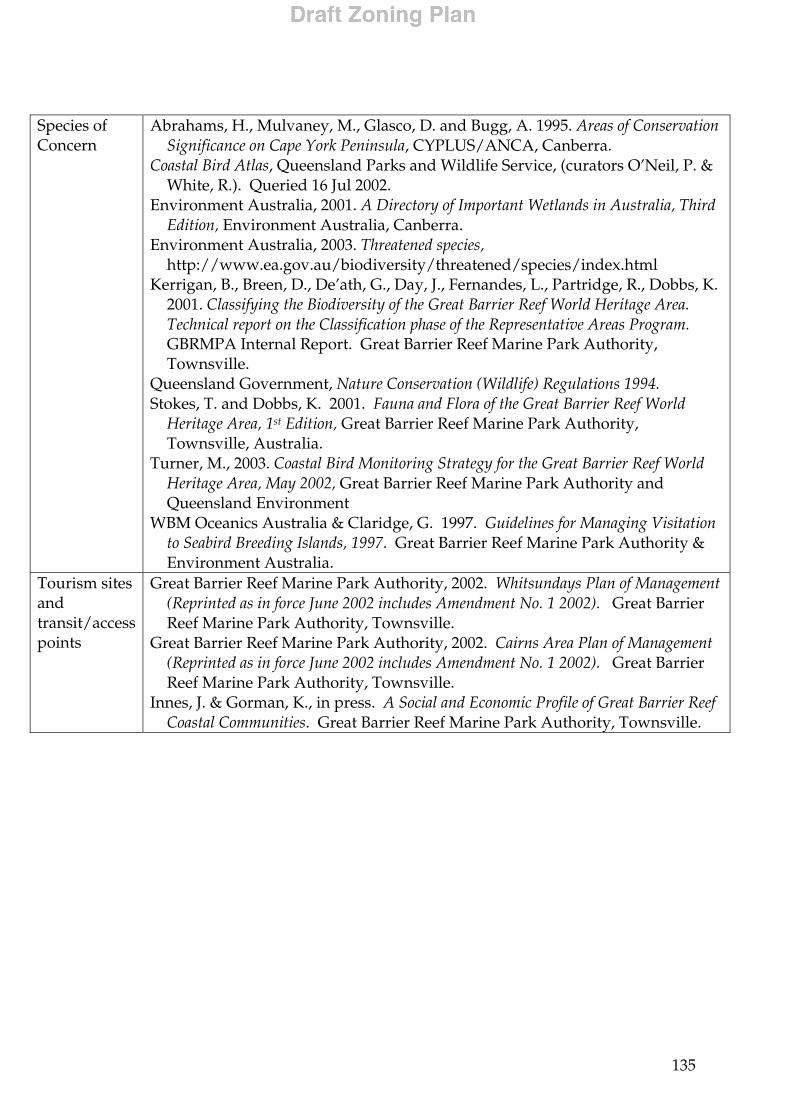
135
Species of Concern
Abrahams, H., Mulvaney, M., Glasco, D. and Bugg, A. 1995. Areas of Conservation Significance on Cape York Peninsula, CYPLUS/ANCA, Canberra.
Coastal Bird Atlas, Queensland Parks and Wildlife Service, (curators O’Neil, P. & White, R.). Queried 16 Jul 2002.
Environment Australia, 2001. A Directory of Important Wetlands in Australia, Third Edition, Environment Australia, Canberra.
Environment Australia, 2003. Threatened species, http://www.ea.gov.au/biodiversity/threatened/species/index.html
Kerrigan, B., Breen, D., De’ath, G., Day, J., Fernandes, L., Partridge, R., Dobbs, K. 2001. Classifying the Biodiversity of the Great Barrier Reef World Heritage Area. Technical report on the Classification phase of the Representative Areas Program. GBRMPA Internal Report. Great Barrier Reef Marine Park Authority, Townsville.
Queensland Government, Nature Conservation (Wildlife) Regulations 1994. Stokes, T. and Dobbs, K. 2001. Fauna and Flora of the Great Barrier Reef World
Heritage Area, 1st Edition, Great Barrier Reef Marine Park Authority, Townsville, Australia.
Turner, M., 2003. Coastal Bird Monitoring Strategy for the Great Barrier Reef World Heritage Area, May 2002, Great Barrier Reef Marine Park Authority and Queensland Environment
WBM Oceanics Australia & Claridge, G. 1997. Guidelines for Managing Visitation to Seabird Breeding Islands, 1997. Great Barrier Reef Marine Park Authority & Environment Australia.
Tourism sites and transit/access points
Great Barrier Reef Marine Park Authority, 2002. Whitsundays Plan of Management (Reprinted as in force June 2002 includes Amendment No. 1 2002). Great Barrier Reef Marine Park Authority, Townsville.
Great Barrier Reef Marine Park Authority, 2002. Cairns Area Plan of Management (Reprinted as in force June 2002 includes Amendment No. 1 2002). Great Barrier Reef Marine Park Authority, Townsville.
Innes, J. & Gorman, K., in press. A Social and Economic Profile of Great Barrier Reef Coastal Communities. Great Barrier Reef Marine Park Authority, Townsville.
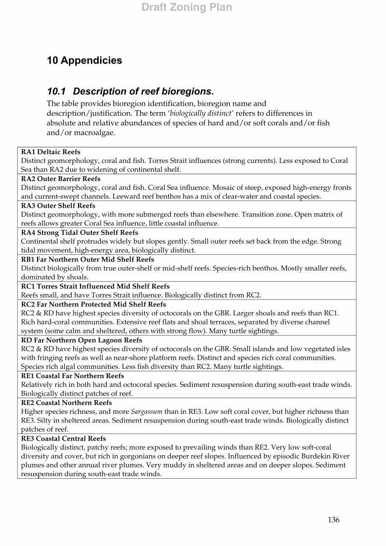
136
10 Appendicies
10.1 Description of reef bioregions. The table provides bioregion identification, bioregion name and description/justification. The term ‘biologically distinct’ refers to differences in absolute and relative abundances of species of hard and/or soft corals and/or fish and/or macroalgae.
RA1 Deltaic Reefs Distinct geomorphology, coral and fish. Torres Strait influences (strong currents). Less exposed to Coral Sea than RA2 due to widening of continental shelf. RA2 Outer Barrier Reefs Distinct geomorphology, coral and fish. Coral Sea influence. Mosaic of steep, exposed high-energy fronts and current-swept channels. Leeward reef benthos has a mix of clear-water and coastal species. RA3 Outer Shelf Reefs Distinct geomorphology, with more submerged reefs than elsewhere. Transition zone. Open matrix of reefs allows greater Coral Sea influence, little coastal influence. RA4 Strong Tidal Outer Shelf Reefs Continental shelf protrudes widely but slopes gently. Small outer reefs set back from the edge. Strong tidal movement, high-energy area, biologically distinct. RB1 Far Northern Outer Mid Shelf Reefs Distinct biologically from true outer-shelf or mid-shelf reefs. Species-rich benthos. Mostly smaller reefs, dominated by shoals. RC1 Torres Strait Influenced Mid Shelf Reefs Reefs small, and have Torres Strait influence. Biologically distinct from RC2. RC2 Far Northern Protected Mid Shelf Reefs RC2 & RD have highest species diversity of octocorals on the GBR. Larger shoals and reefs than RC1. Rich hard-coral communities. Extensive reef flats and shoal terraces, separated by diverse channel system (some calm and sheltered, others with strong flow). Many turtle sightings. RD Far Northern Open Lagoon Reefs RC2 & RD have highest species diversity of octocorals on the GBR. Small islands and low vegetated isles with fringing reefs as well as near-shore platform reefs. Distinct and species rich coral communities. Species rich algal communities. Less fish diversity than RC2. Many turtle sightings. RE1 Coastal Far Northern Reefs Relatively rich in both hard and octocoral species. Sediment resuspension during south-east trade winds. Biologically distinct patches of reef. RE2 Coastal Northern Reefs Higher species richness, and more Sargassum than in RE3. Low soft coral cover, but higher richness than RE3. Silty in sheltered areas. Sediment resuspension during south-east trade winds. Biologically distinct patches of reef. RE3 Coastal Central Reefs Biologically distinct, patchy reefs; more exposed to prevailing winds than RE2. Very low soft-coral diversity and cover, but rich in gorgonians on deeper reef slopes. Influenced by episodic Burdekin River plumes and other annual river plumes. Very muddy in sheltered areas and on deeper slopes. Sediment resuspension during south-east trade winds.
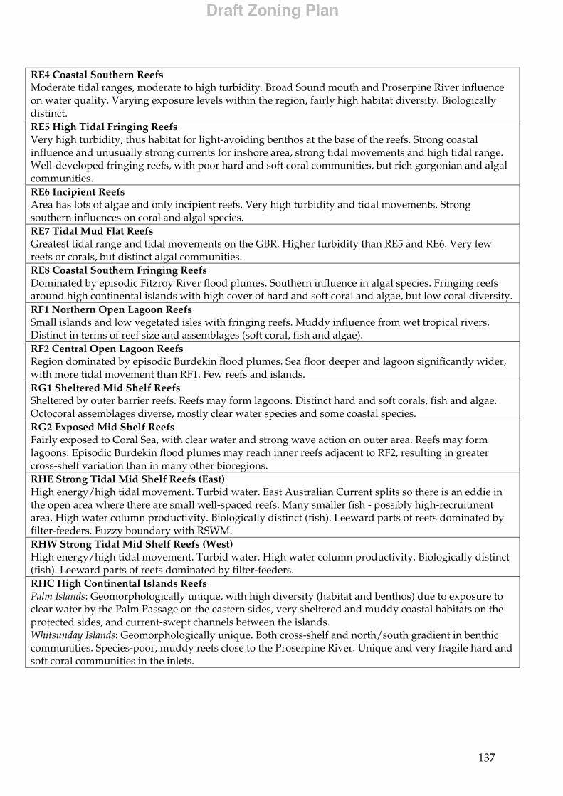
137
RE4 Coastal Southern Reefs Moderate tidal ranges, moderate to high turbidity. Broad Sound mouth and Proserpine River influence on water quality. Varying exposure levels within the region, fairly high habitat diversity. Biologically distinct. RE5 High Tidal Fringing Reefs Very high turbidity, thus habitat for light-avoiding benthos at the base of the reefs. Strong coastal influence and unusually strong currents for inshore area, strong tidal movements and high tidal range. Well-developed fringing reefs, with poor hard and soft coral communities, but rich gorgonian and algal communities. RE6 Incipient Reefs Area has lots of algae and only incipient reefs. Very high turbidity and tidal movements. Strong southern influences on coral and algal species. RE7 Tidal Mud Flat Reefs Greatest tidal range and tidal movements on the GBR. Higher turbidity than RE5 and RE6. Very few reefs or corals, but distinct algal communities. RE8 Coastal Southern Fringing Reefs Dominated by episodic Fitzroy River flood plumes. Southern influence in algal species. Fringing reefs around high continental islands with high cover of hard and soft coral and algae, but low coral diversity. RF1 Northern Open Lagoon Reefs Small islands and low vegetated isles with fringing reefs. Muddy influence from wet tropical rivers. Distinct in terms of reef size and assemblages (soft coral, fish and algae). RF2 Central Open Lagoon Reefs Region dominated by episodic Burdekin flood plumes. Sea floor deeper and lagoon significantly wider, with more tidal movement than RF1. Few reefs and islands. RG1 Sheltered Mid Shelf Reefs Sheltered by outer barrier reefs. Reefs may form lagoons. Distinct hard and soft corals, fish and algae. Octocoral assemblages diverse, mostly clear water species and some coastal species. RG2 Exposed Mid Shelf Reefs Fairly exposed to Coral Sea, with clear water and strong wave action on outer area. Reefs may form lagoons. Episodic Burdekin flood plumes may reach inner reefs adjacent to RF2, resulting in greater cross-shelf variation than in many other bioregions. RHE Strong Tidal Mid Shelf Reefs (East) High energy/high tidal movement. Turbid water. East Australian Current splits so there is an eddie in the open area where there are small well-spaced reefs. Many smaller fish - possibly high-recruitment area. High water column productivity. Biologically distinct (fish). Leeward parts of reefs dominated by filter-feeders. Fuzzy boundary with RSWM. RHW Strong Tidal Mid Shelf Reefs (West) High energy/high tidal movement. Turbid water. High water column productivity. Biologically distinct (fish). Leeward parts of reefs dominated by filter-feeders. RHC High Continental Islands Reefs Palm Islands: Geomorphologically unique, with high diversity (habitat and benthos) due to exposure to clear water by the Palm Passage on the eastern sides, very sheltered and muddy coastal habitats on the protected sides, and current-swept channels between the islands. Whitsunday Islands: Geomorphologically unique. Both cross-shelf and north/south gradient in benthic communities. Species-poor, muddy reefs close to the Proserpine River. Unique and very fragile hard and soft coral communities in the inlets.
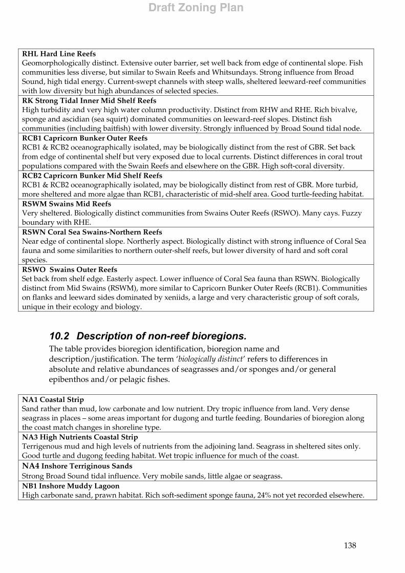
138
RHL Hard Line Reefs Geomorphologically distinct. Extensive outer barrier, set well back from edge of continental slope. Fish communities less diverse, but similar to Swain Reefs and Whitsundays. Strong influence from Broad Sound, high tidal energy. Current-swept channels with steep walls, sheltered leeward-reef communities with low diversity but high abundances of selected species. RK Strong Tidal Inner Mid Shelf Reefs High turbidity and very high water column productivity. Distinct from RHW and RHE. Rich bivalve, sponge and ascidian (sea squirt) dominated communities on leeward-reef slopes. Distinct fish communities (including baitfish) with lower diversity. Strongly influenced by Broad Sound tidal node. RCB1 Capricorn Bunker Outer Reefs RCB1 & RCB2 oceanographically isolated, may be biologically distinct from the rest of GBR. Set back from edge of continental shelf but very exposed due to local currents. Distinct differences in coral trout populations compared with the Swain Reefs and elsewhere on the GBR. High soft-coral diversity. RCB2 Capricorn Bunker Mid Shelf Reefs RCB1 & RCB2 oceanographically isolated, may be biologically distinct from rest of GBR. More turbid, more sheltered and more algae than RCB1, characteristic of mid-shelf area. Good turtle-feeding habitat. RSWM Swains Mid Reefs Very sheltered. Biologically distinct communities from Swains Outer Reefs (RSWO). Many cays. Fuzzy boundary with RHE. RSWN Coral Sea Swains-Northern Reefs Near edge of continental slope. Northerly aspect. Biologically distinct with strong influence of Coral Sea fauna and some similarities to northern outer-shelf reefs, but lower diversity of hard and soft coral species. RSWO Swains Outer Reefs Set back from shelf edge. Easterly aspect. Lower influence of Coral Sea fauna than RSWN. Biologically distinct from Mid Swains (RSWM), more similar to Capricorn Bunker Outer Reefs (RCB1). Communities on flanks and leeward sides dominated by xeniids, a large and very characteristic group of soft corals, unique in their ecology and biology.
10.2 Description of non-reef bioregions. The table provides bioregion identification, bioregion name and description/justification. The term ‘biologically distinct’ refers to differences in absolute and relative abundances of seagrasses and/or sponges and/or general epibenthos and/or pelagic fishes.
NA1 Coastal Strip Sand rather than mud, low carbonate and low nutrient. Dry tropic influence from land. Very dense seagrass in places – some areas important for dugong and turtle feeding. Boundaries of bioregion along the coast match changes in shoreline type. NA3 High Nutrients Coastal Strip Terrigenous mud and high levels of nutrients from the adjoining land. Seagrass in sheltered sites only. Good turtle and dugong feeding habitat. Wet tropic influence for much of the coast. NA4 Inshore Terriginous Sands Strong Broad Sound tidal influence. Very mobile sands, little algae or seagrass. NB1 Inshore Muddy Lagoon High carbonate sand, prawn habitat. Rich soft-sediment sponge fauna, 24% not yet recorded elsewhere.

139
NB3 Inner Shelf Seagrass Fine sediment area with distinct invertebrate and fish communities. Seasonal seagrass in patches. Distinct gorgonian fauna, associated with low wooded islands. Boundary for sponges and gorgonians extends south to Cape Grafton only. NB5 Inner Mid Shelf Lagoon Coarse sediment from land influences (medium-high land input). Sparse seagrass. NB6 Inner Shelf Lagoon Continental Islands Strong currents with some gravel and hydroids around Pine Peak Island. Some gorgonians and low reef sites, water very turbid. Seagrass meadows in some bays. NB7 Mid Shelf Lagoon Muds dominate, minimal algae or seagrass. Leeward parts of Hook and Bait Reefs are geomorphologically different. Very steep, extensive benthos, gravel, low sponge diversity but only 21% of species are similar to those in southern lagoonal reefs. Mobile sand dunes influenced by strong East Australian Current. NB8 Capricorn Bunker Lagoon Halimeda and seagrass up to 50% cover. Mixing of southern inshore and tropical inshore sponge species, 28% not yet found elsewhere. NC Mid Shelf Inter Reef - Seagrass Fine sediments, high carbonate content between a large number of reefs. Contains deep water shoals. ND Mid Shelf Inter Reef Shelly sands, almost no fine sediments. Very little seagrass. Abundant crinoids (feather stars). NE Outer Shelf Lagoon Halimeda Banks. Caulerpa goes only as far as the inner edge of the shelf edge. Eastern boundary follows the inner boundary of the Ribbon Reefs. NF Halimeda Banks – some coral Halimeda and Caulerpa banks with deep rubble reef or sparse coral patches. NE/NF boundary follows Pollard Channel. NH Mid Shelf Sandy Inter Reef Fine sediment low density seagrass beds, known turtle foraging sites. NI Halimeda Banks Dense Halimeda, almost no coral, some seagrass. NJ Princess Charlotte Bay Outer Shelf Sandy change to carbonate sediments. Red-spot king prawn grounds. NK Princess Charlotte Bay Muddy bay, surrounded by silica sand deposits with low nutrient levels. Some seagrass. NL1 Outer Shelf Algae and Seagrass Areas of medium density seagrass and medium density algae, diverse solitary corals. High diversity of sponge species at Lizard Island and North and South Direction Groups, 28% not yet recorded elsewhere on the GBR. NL2 Outer Shelf Seagrass Some shelly sands (very coarse) with smaller areas of seagrass and algal gardens (low density). NL3 Outer Shelf Inter Reef - Central Shelly sands with very sparse algae and seagrasses. NL4 Outer Shelf Inter Reef - Southern High currents. Coarse sediments. Available data indicates low biomass and high diversity of biota.
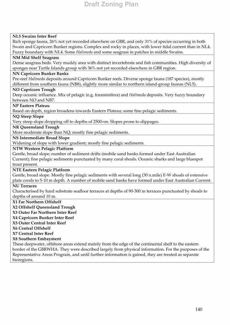
140
NL5 Swains Inter Reef Rich sponge fauna, 26% not yet recorded elsewhere on GBR, and only 31% of species occurring in both Swain and Capricorn Bunker regions. Complex and rocky in places, with lower tidal current than in NL4. Fuzzy boundary with NL4. Some Halimeda and some seagrass in patches in middle Swains. NM Mid Shelf Seagrass Dense seagrass beds. Very muddy area with distinct invertebrate and fish communities. High diversity of sponges near Turtle Islands group with 36% not yet recorded elsewhere in GBR region. NN Capricorn Bunker Banks Pre-reef Halimeda deposits around Capricorn Bunker reefs. Diverse sponge fauna (187 species), mostly different from southern fauna (NB8), slightly more similar to northern island-group faunas (NL5). NO Capricorn Trough Deep oceanic influence. Mix of pelagic (e.g. foraminifera) and Halimeda deposits. Very fuzzy boundary between NO and NB7. NP Eastern Plateau Based on depth, region broadens towards Eastern Plateau; some fine pelagic sediments. NQ Steep Slope Very steep slope dropping off to depths of 2500+m. Slopes prone to slippages. NR Queensland Trough More moderate slope than NQ; mostly fine pelagic sediments. NS Intermediate Broad Slope Widening of slope with lower gradient; mostly fine pelagic sediments. NTW Western Pelagic Platform Gentle, broad slope; number of sediment drifts (mobile sand banks formed under East Australian Current); fine pelagic sediments punctuated by many coral shoals. Oceanic sharks and large bluespot trout present. NTE Eastern Pelagic Platform Gentle, broad slope. Mostly fine pelagic sediments with several long (30 n.mile) E-W shoals of extensive plate corals to 5-10 m depth. A number of mobile sand banks have formed under East Australian Current. NU Terraces Characterised by hard substrate seafloor terraces at depths of 90-300 m terraces punctuated by shoals to depths of around 10 m. X1 Far Northern Offshelf X2 Offshelf Queensland Trough X3 Outer Far Northern Inter Reef X4 Capricorn Bunker Inter Reef X5 Outer Central Inter Reef X6 Central Offshelf X7 Central Inter Reef X8 Southern Embayment These deepwater, offshore areas extend mainly from the edge of the continental shelf to the eastern border of the GBRWHA. They were described largely from physical information. For the purposes of the Representative Areas Program, and until further information is gained, they are treated as separate bioregions.

141
10.3 New coastal areas map
This page is intentionally blank.