government of nepal ministry of environment...
TRANSCRIPT

Page 1 of 4
Government of Nepal Ministry of Environment Department of Hydrology and Meteorology Babarmahal, Kathmandu, Nepal
PRELIMINARY WEATHER SUMMARY OF NEPAL
August 2009
MAIN HIGHLIGHT
Large parts of the country remained warmer than normal with normal to above normal rainfall. However, the heavy rainfall throughout the country especially during the first and fourth week triggered several floods and landslides across the country. 24 districts were affected claiming more than 40 lives and affecting more than 14,000 families, according to the Nepal Red Cross Society (NRCS).
SYNOPTIC SEQUENCES:
Monsoon Trough (MT)
The Axis of MT this month oscillated between normal and north of the normal position most of the times. During the first week, it lay north of the normal position close to the foothills of the Himalayas. It then shifted southward to normal position and persisted there the whole of the second week. It moved north after 17th and remained there till the first half of the fourth week. Then it moved to the normal position till 24th and then slightly moved to south of its normal position on 27th and 28th, close to its normal position on 29th, thereafter the eastern parts of the monsoon trough was south of its normal position whereas western part of the monsoon trough lay close to its normal position.
A secondary trough also formed over Bihar extending to northern Bay of Bengal across Gangetic West Bengal & Bangladesh during the first week.
Upper Air Cyclonic Circulation (UACC)
Two UACCs formed in the second week, two in the third week and one in the fourth week and end of the month, over northwest Bay of Bengal (BoB) and Gangetic plain over northern India. These systems extended up to mid-tropospheric levels and moved westward. These systems persisted almost throughout each week.
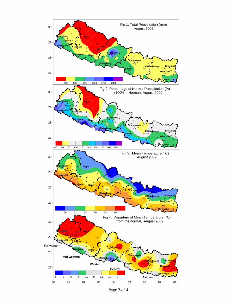
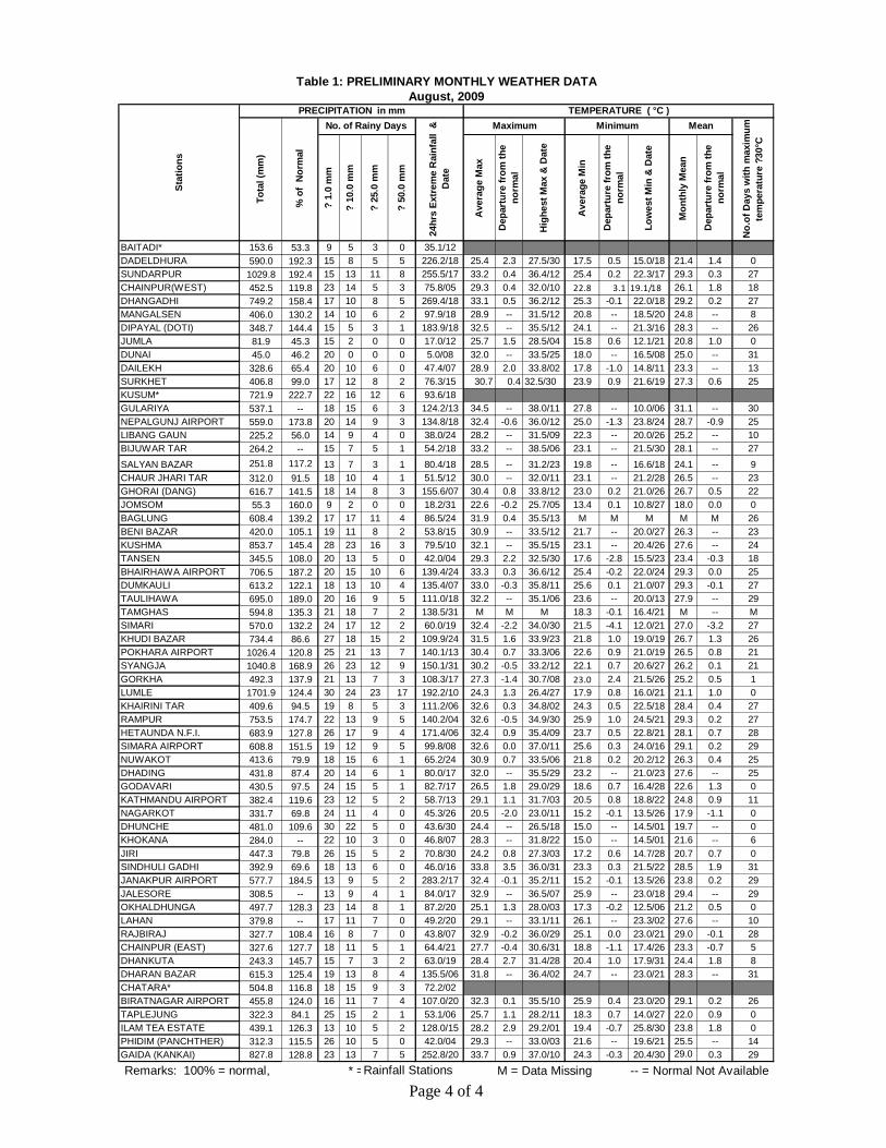
PRECIPITATION DISTRIBUTION: August is the second wettest month for Nepal. This year, rainfall in August was normal to above normal in large parts of the country (Figure 2). Terai regions in particular received much above normal rainfall compared to the other places. The southern plains of Central, Western, Mid-western and Far-western regions recorded over 140% of the normal rainfall for this month. Below normal (<80%) rainfall was recorded in the central and northern parts of the Mid-western region. Some of the areas recorded below 60% of the normal rainfall. Rainfall during the first and the third week of August was particularly intense and widespread mainly due to the monsoon trough lying in the foothills of the Himalayas. Rainfall varied between less than 250 mm in the usually drier region of the Mid-western Region to above 1500 mm in Lumle (Figure 1). Dadeldhura, Dhangdhi and Dipayal in the Far-western region broke all the previous recorded historical highest 24 hour rainfall recording 226.2 mm, 269.4 mm and 183.9 mm of rainfall respectively on 17-18 August 2009.
Page 2 of 4
Similarly Dang in the Mid-western region recorded 155.6 mm of rainfall on 6-7 August 2009 breaking all the previous historical August extreme rainfall. TEMPERATURE PATTERN: Large parts of the country remained warmer than normal in August. Positive temperature anomaly of more than 1 °C was observed north-western parts and in spotty areas in the Eastern, Central and Western Regions (Figure 4). Though some isolated areas recorded slightly below normal temperature Simari in the Western region recorded the lowest temperature anomaly of -3.2 °C. The mean temperature varied between below 20 °C in the north to above 30 °C in the southern plains (Figure 3, Table 1). The preliminary weather data for August 2009 is presented in Table 1.
Page 3 of 4
Fig 3: Mean Temperature (°C) August 2009
Fig 4: Departure of Mean Temperature (°C) from the normal, August 2009
Fig 1: Total Precipitation (mm)August 2009
Fig 2: Percentage of Normal Precipitation (%) (100% = Normal), August 2009
Eastern
CentralWestern
Mid-western
Far-western
27
28
29
30
Dipayal
Dadeldhura
Dhangadhi
Jumla
Surkhet
Nepalgunj Dang
Bhairahawa
Pokhara
Simara
Kathmandu
Okhaldhunga
Dhankuta
Biratnagar
Taplejung
40 60 80 100 120 140 160 180 200 220
-250 250 500 750 1000 1250 1500
27
28
29
30
Dipayal
Dadeldhura
Dhangadhi
Jumla
Surkhet
Nepalgunj Dang
Bhairahawa
Pokhara
Simara
Kathmandu
Okhaldhunga
Dhankuta
Biratnagar
Taplejung
-4 -3 -2 -1 -0.2 0 0.2 0.5 1
80 81 82 83 84 85 86 87 88
27
28
29
30
Dipayal
Dadeldhura
Dhangadhi
Jumla
Surkhet
Nepalgunj Dang
Bhairahawa
Pokhara
Simara
Kathmandu
Okhaldhunga
Dhankuta
Biratnagar
Taplejung
27
28
29
30
Dipayal
Dadeldhura
Dhangadhi
Jumla
Surkhet
Nepalgunj Dang
Bhairahawa
Pokhara
Simara
Kathmandu
Okhaldhunga
Dhankuta
Biratnagar
Taplejung
16 20 22 24 26 28 30
Page 4 of 4
? 1.
0 m
m
? 10
.0 m
m
? 25
.0 m
m
? 50
.0 m
m
Ave
rage
Max
Dep
artu
re fr
om th
e no
rmal
Hig
hest
Max
& D
ate
Ave
rage
Min
Dep
artu
re fr
om th
e no
rmal
Low
est M
in &
Dat
e
Mon
thly
Mea
n
Dep
artu
re fr
om th
e no
rmal
BAITADI* 153.6 53.3 9 5 3 0 35.1/12DADELDHURA 590.0 192.3 15 8 5 5 226.2/18 25.4 2.3 27.5/30 17.5 0.5 15.0/18 21.4 1.4 0SUNDARPUR 1029.8 192.4 15 13 11 8 255.5/17 33.2 0.4 36.4/12 25.4 0.2 22.3/17 29.3 0.3 27CHAINPUR(WEST) 452.5 119.8 23 14 5 3 75.8/05 29.3 0.4 32.0/10 22.8 3.1 19.1/18 26.1 1.8 18DHANGADHI 749.2 158.4 17 10 8 5 269.4/18 33.1 0.5 36.2/12 25.3 -0.1 22.0/18 29.2 0.2 27MANGALSEN 406.0 130.2 14 10 6 2 97.9/18 28.9 -- 31.5/12 20.8 -- 18.5/20 24.8 -- 8DIPAYAL (DOTI) 348.7 144.4 15 5 3 1 183.9/18 32.5 -- 35.5/12 24.1 -- 21.3/16 28.3 -- 26JUMLA 81.9 45.3 15 2 0 0 17.0/12 25.7 1.5 28.5/04 15.8 0.6 12.1/21 20.8 1.0 0DUNAI 45.0 46.2 20 0 0 0 5.0/08 32.0 -- 33.5/25 18.0 -- 16.5/08 25.0 -- 31DAILEKH 328.6 65.4 20 10 6 0 47.4/07 28.9 2.0 33.8/02 17.8 -1.0 14.8/11 23.3 -- 13SURKHET 406.8 99.0 17 12 8 2 76.3/15 30.7 0.4 32.5/30 23.9 0.9 21.6/19 27.3 0.6 25KUSUM* 721.9 222.7 22 16 12 6 93.6/18GULARIYA 537.1 -- 18 15 6 3 124.2/13 34.5 -- 38.0/11 27.8 -- 10.0/06 31.1 -- 30NEPALGUNJ AIRPORT 559.0 173.8 20 14 9 3 134.8/18 32.4 -0.6 36.0/12 25.0 -1.3 23.8/24 28.7 -0.9 25LIBANG GAUN 225.2 56.0 14 9 4 0 38.0/24 28.2 -- 31.5/09 22.3 -- 20.0/26 25.2 -- 10BIJUWAR TAR 264.2 -- 15 7 5 1 54.2/18 33.2 -- 38.5/06 23.1 -- 21.5/30 28.1 -- 27
SALYAN BAZAR 251.8 117.2 13 7 3 1 80.4/18 28.5 -- 31.2/23 19.8 -- 16.6/18 24.1 -- 9CHAUR JHARI TAR 312.0 91.5 18 10 4 1 51.5/12 30.0 -- 32.0/11 23.1 -- 21.2/28 26.5 -- 23GHORAI (DANG) 616.7 141.5 18 14 8 3 155.6/07 30.4 0.8 33.8/12 23.0 0.2 21.0/26 26.7 0.5 22JOMSOM 55.3 160.0 9 2 0 0 18.2/31 22.6 -0.2 25.7/05 13.4 0.1 10.8/27 18.0 0.0 0BAGLUNG 608.4 139.2 17 17 11 4 86.5/24 31.9 0.4 35.5/13 M M M M M 26BENI BAZAR 420.0 105.1 19 11 8 2 53.8/15 30.9 -- 33.5/12 21.7 -- 20.0/27 26.3 -- 23KUSHMA 853.7 145.4 28 23 16 3 79.5/10 32.1 -- 35.5/15 23.1 -- 20.4/26 27.6 -- 24TANSEN 345.5 108.0 20 13 5 0 42.0/04 29.3 2.2 32.5/30 17.6 -2.8 15.5/23 23.4 -0.3 18BHAIRHAWA AIRPORT 706.5 187.2 20 15 10 6 139.4/24 33.3 0.3 36.6/12 25.4 -0.2 22.0/24 29.3 0.0 25DUMKAULI 613.2 122.1 18 13 10 4 135.4/07 33.0 -0.3 35.8/11 25.6 0.1 21.0/07 29.3 -0.1 27TAULIHAWA 695.0 189.0 20 16 9 5 111.0/18 32.2 -- 35.1/06 23.6 -- 20.0/13 27.9 -- 29TAMGHAS 594.8 135.3 21 18 7 2 138.5/31 M M M 18.3 -0.1 16.4/21 M -- MSIMARI 570.0 132.2 24 17 12 2 60.0/19 32.4 -2.2 34.0/30 21.5 -4.1 12.0/21 27.0 -3.2 27KHUDI BAZAR 734.4 86.6 27 18 15 2 109.9/24 31.5 1.6 33.9/23 21.8 1.0 19.0/19 26.7 1.3 26POKHARA AIRPORT 1026.4 120.8 25 21 13 7 140.1/13 30.4 0.7 33.3/06 22.6 0.9 21.0/19 26.5 0.8 21SYANGJA 1040.8 168.9 26 23 12 9 150.1/31 30.2 -0.5 33.2/12 22.1 0.7 20.6/27 26.2 0.1 21GORKHA 492.3 137.9 21 13 7 3 108.3/17 27.3 -1.4 30.7/08 23.0 2.4 21.5/26 25.2 0.5 1LUMLE 1701.9 124.4 30 24 23 17 192.2/10 24.3 1.3 26.4/27 17.9 0.8 16.0/21 21.1 1.0 0KHAIRINI TAR 409.6 94.5 19 8 5 3 111.2/06 32.6 0.3 34.8/02 24.3 0.5 22.5/18 28.4 0.4 27RAMPUR 753.5 174.7 22 13 9 5 140.2/04 32.6 -0.5 34.9/30 25.9 1.0 24.5/21 29.3 0.2 27HETAUNDA N.F.I. 683.9 127.8 26 17 9 4 171.4/06 32.4 0.9 35.4/09 23.7 0.5 22.8/21 28.1 0.7 28SIMARA AIRPORT 608.8 151.5 19 12 9 5 99.8/08 32.6 0.0 37.0/11 25.6 0.3 24.0/16 29.1 0.2 29NUWAKOT 413.6 79.9 18 15 6 1 65.2/24 30.9 0.7 33.5/06 21.8 0.2 20.2/12 26.3 0.4 25DHADING 431.8 87.4 20 14 6 1 80.0/17 32.0 -- 35.5/29 23.2 -- 21.0/23 27.6 -- 25GODAVARI 430.5 97.5 24 15 5 1 82.7/17 26.5 1.8 29.0/29 18.6 0.7 16.4/28 22.6 1.3 0KATHMANDU AIRPORT 382.4 119.6 23 12 5 2 58.7/13 29.1 1.1 31.7/03 20.5 0.8 18.8/22 24.8 0.9 11NAGARKOT 331.7 69.8 24 11 4 0 45.3/26 20.5 -2.0 23.0/11 15.2 -0.1 13.5/26 17.9 -1.1 0DHUNCHE 481.0 109.6 30 22 5 0 43.6/30 24.4 -- 26.5/18 15.0 -- 14.5/01 19.7 -- 0KHOKANA 284.0 -- 22 10 3 0 46.8/07 28.3 -- 31.8/22 15.0 -- 14.5/01 21.6 -- 6JIRI 447.3 79.8 26 15 5 2 70.8/30 24.2 0.8 27.3/03 17.2 0.6 14.7/28 20.7 0.7 0SINDHULI GADHI 392.9 69.6 18 13 6 0 46.0/16 33.8 3.5 36.0/31 23.3 0.3 21.5/22 28.5 1.9 31JANAKPUR AIRPORT 577.7 184.5 13 9 5 2 283.2/17 32.4 -0.1 35.2/11 15.2 -0.1 13.5/26 23.8 0.2 29JALESORE 308.5 -- 13 9 4 1 84.0/17 32.9 -- 36.5/07 25.9 -- 23.0/18 29.4 -- 29OKHALDHUNGA 497.7 128.3 23 14 8 1 87.2/20 25.1 1.3 28.0/03 17.3 -0.2 12.5/06 21.2 0.5 0LAHAN 379.8 -- 17 11 7 0 49.2/20 29.1 -- 33.1/11 26.1 -- 23.3/02 27.6 -- 10RAJBIRAJ 327.7 108.4 16 8 7 0 43.8/07 32.9 -0.2 36.0/29 25.1 0.0 23.0/21 29.0 -0.1 28CHAINPUR (EAST) 327.6 127.7 18 11 5 1 64.4/21 27.7 -0.4 30.6/31 18.8 -1.1 17.4/26 23.3 -0.7 5DHANKUTA 243.3 145.7 15 7 3 2 63.0/19 28.4 2.7 31.4/28 20.4 1.0 17.9/31 24.4 1.8 8DHARAN BAZAR 615.3 125.4 19 13 8 4 135.5/06 31.8 -- 36.4/02 24.7 -- 23.0/21 28.3 -- 31CHATARA* 504.8 116.8 18 15 9 3 72.2/02BIRATNAGAR AIRPORT 455.8 124.0 16 11 7 4 107.0/20 32.3 0.1 35.5/10 25.9 0.4 23.0/20 29.1 0.2 26TAPLEJUNG 322.3 84.1 25 15 2 1 53.1/06 25.7 1.1 28.2/11 18.3 0.7 14.0/27 22.0 0.9 0ILAM TEA ESTATE 439.1 126.3 13 10 5 2 128.0/15 28.2 2.9 29.2/01 19.4 -0.7 25.8/30 23.8 1.8 0PHIDIM (PANCHTHER) 312.3 115.5 26 10 5 0 42.0/04 29.3 -- 33.0/03 21.6 -- 19.6/21 25.5 -- 14GAIDA (KANKAI) 827.8 128.8 23 13 7 5 252.8/20 33.7 0.9 37.0/10 24.3 -0.3 20.4/30 29.0 0.3 29
Remarks: 100% = normal, * =Rainfall Stations M = Data Missing -- = Normal Not Available
No. of Rainy Days
24hr
s Ex
trem
e R
ainf
all
&
Dat
e
Maximum Minimum Mean
No.
of D
ays
with
max
imum
te
mpe
ratu
re ?
30°C
Table 1: PRELIMINARY MONTHLY WEATHER DATAAugust, 2009
Stat
ions
PRECIPITATION in mm TEMPERATURE ( °C )
Tota
l (m
m)
% o
f N
orm
al