government gazette no 132 of thursday 1 april 2021
TRANSCRIPT

NSW Government Gazette No 132 of 1 April 2021
Government Gazetteof the State of
New South WalesNumber 132ndashCompulsory Acquisitions
Thursday 1 April 2021
GOVERNMENT GAZETTE ndash 4 September 2020
The New South Wales Government Gazette is the permanent public record of official NSW Government noticesIt also contains local council non-government and other notices
Each notice in the Government Gazette has a unique reference number that appears in parentheses at the end of thenotice and can be used as a reference for that notice (for example (n2019-14))
The Gazette is compiled by the Parliamentary Counselrsquos Office and published on the NSW legislation website(wwwlegislationnswgovau) under the authority of the NSW Government The website contains a permanentarchive of past Gazettes
To submit a notice for gazettal see the Gazette page
By AuthorityGovernment PrinterISSN 2201-7534
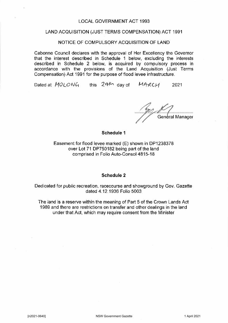
LOCAL GOVERNMENT ACT 1993
LAND ACQUISITION (JUST TERMS COMPENSATION) ACT 1991
NOTICE OF COMPULSORY ACQUISITION OF LAND
Cabonne Council declares with the approval of Her Excellency the Governor that the interest described in Schedule 1 below excluding the interests described in Schedule 2 below is acquired by compulsory process in accordance with the provisions of the Land Acquisition (Just Terms Compensation) Act 1991 for the purpose of flood levee infrastructure
Dated at MOLONCI this 2 6141 day of f-4VCH 2021
General Manager
Schedule 1
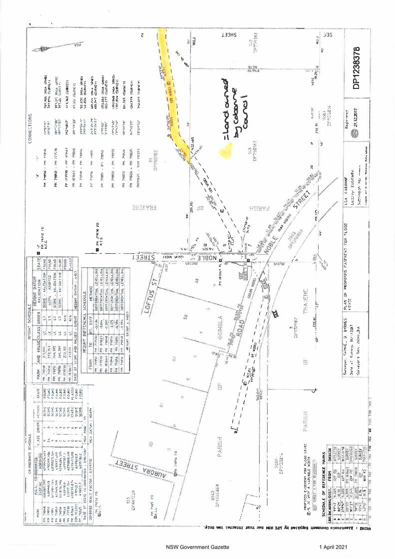
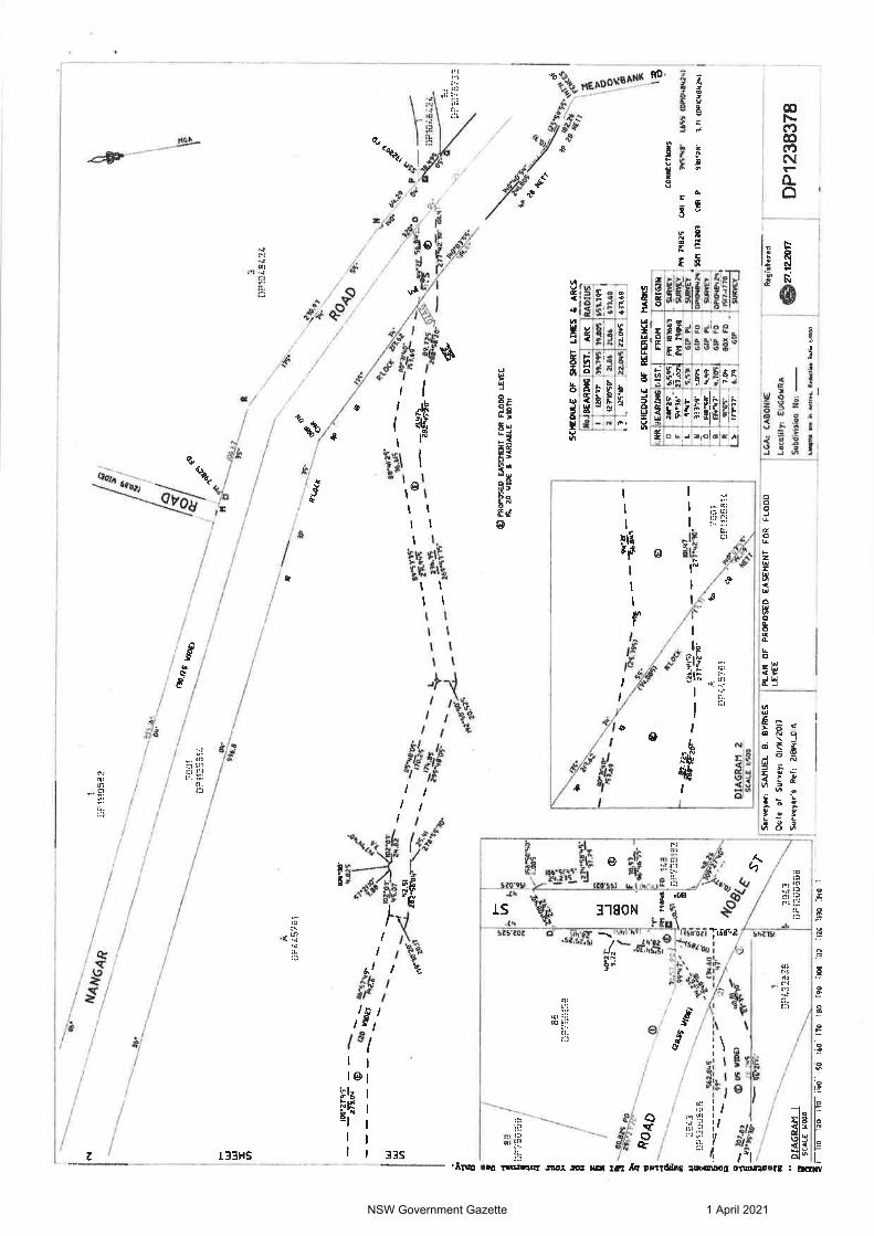
Easement for flood levee marked (E) shown in DP1238378 over Lot 71 DP750182 being part of the land
comprised in Folio Auto-Consol 4815-18
Schedule 2
Dedicated for public recreation racecourse and showground by Gov Gazette dated 4121936 Folio 5003
The land is a reserve within the meaning of Part 5 of the Crown Lands Act 1989 and there are restrictions on transfer and other dealings in the land
under that Act which may require consent from the Minister
[n2021-0640] NSW Government Gazette 1 April 2021
NSW Government Gazette 1 April 2021
NSW Government Gazette 1 April 2021
NSW Government Gazette 1 April 2021
NSW Government Gazette 1 April 2021
LOCAL GOVERNMENT ACT 1993
LAND ACQUISITION (JUST TERMS COMPENSATION) ACT 1991
NOTICE OF COMPULSORY ACQUISITION OF LAND
Cabonne Council declares with the approval of Her Excellency the Governor that the interest described in the Schedule below is acquired by compulsory process in accordance with the provisions of the Land Acquisition (Just Terms Compensation) Act 1991 for the purpose of flood levee infrastructure
Dated at M 0 LONG this 2(4 4-k day of tifkg(44 2021
Ge eral Manager
Schedule
Easement for flood levee marked (E) shown in DP1238378 over Lot 7001 DP1125814 being part of the land
comprised in Folio 70011125814
[n2021-0641] NSW Government Gazette 1 April 2021
a
O
COORDINATE SCHEDULE
71 MARK CLASS ORDER GA- CO-ORDINATES 1
EASTDIC I NORTH DIG 1 PM 79646 7 628267197 1120932403 8 2 Pm 791330 62844017 6300199483 2A 0 Pr 79651 027264764 6299923364 I B 2
I Pm 79E152 62740799 61052766D a 2 PM 79856 627670396 f 6291264574 C I Pr 79626 I 6281110 1 2949017 E 41 P11 173530 I 6213371514 024981115411 C 3 Pm 1836e3 6213299474 4291441140 0 U S91 132203 6104217 62991206 E S i
HEIGHT SCHEDULE
IT 1 METHOD r STATE MARK AHD VALUE CLASS r GHT DATUM
ORDER I HEI VALIDATION STATE SCNiS bull FOUND - PM 71846 271964 LC LI i SUMS - VALIDATION FOUR PH7TL7995Q
417
SEINE FOUND 1 PH 79050 272739_
_
LC LI SUMS - ADOPTED FOUND SUNS FOUND 1 Pm 79651 269_195 LC
_
LI SCEMS - VALIDATION FOUNDSUMS 1 FOUND SLIMS I FOUND PM 74046 264_786 SEWS FOUND PM 171510 272115
LC
LE
FOUND
FOUND_
LI StfttS - VALIDATION
NA SUMS 1 PCUPID r Pn 163663 272171
STAFIC PLACID IN A r LACED
marl HEICHT 13ATiai 4 AWN 5(1115 I FOUND LDATE OF 5(215 AND VALUES 4
Pm 79825 1 4101277 42993(142 E bdquo S 1 SCRI __1_ FoystD_i 1 DATE OF RIMS CO-ORDINATES 4 1472017 bull T MG ZONE 4 55
ir COMBINED SCALE FACTOR 0999758 MCA OATUm GOA14
PM 79852 FD ONTS
PM 7965 FD UHTS
79856 FD
7 DCI
PROPOSED CASEMENT FOR FLOOD LEVEE 04 20 41IDE a VARIABLE WIDTH
SEE SHEET 3 FOR DIAGRAM I
5628 99-47
I SCHEDULE OF REFERENCE MARKS
7 iFIRJ3EA70NGDI5T FROM )ORIGINA It 99 37- 44025bull ar114 317 4174-1770
IT 111 4 477 142L811k - UPGIFFo 4 117717L bull 2t 412S 6S1C fp 01149 SURVET
F 9414 2360 API 714136 SURVEY 0 I C 41949 _1216
is E viiFii - jor=s GOP 80
ruRVE7
0013268
GOP S 4 -4279 bdquoibdquoPLIt I NO FD 1 7597-17 7 0
5 t-- th To 7 NO- bull4 -161- 51 7 88 irio ma it_ ti 1r 0o 38
PH 79850
P11 (73010
PM 181441
PM 791338
PM 7185C
PM 79851
EIGHT DIFFERENCE SCHEDULE
FROM TO IIHT DIFF METHOD
P11 171510 0434 DIPPEREXTIAL 1EVEIJar4
PM 183443 -0144 BUTE04E1AL LEVELLING
PH 79848 -0207 _ DIFFERENTIAL LEVELLING
P11 79856 -2175 DIFFERENTIAL amiLorc
144 79851 1 4104 otrrocArim LEVELLING
PM 71640 1-194 DIFFERENTIAL LEVEWNGJ
Wean DAWN x AND71
bull 44
to a --
Surveyor SAMUEL 8 BYRNES PLAN OF PROPOSED EASEMENT FOR FLOOD
Date of Survey LU112017 Surveyors Re 218811_01A
goA 2
a I3F7IIIME
2926)39- bull
Bg
1 0 en 171530 FD NTS
1 UT ti
1171
nlcoz
$1
L4
PM 43668 Pt
DI
fir4SEE
e45
208
0 3r
WI
CLI 0
I
99bull
PM 791350 - PM 798411
PM 79E150 - PM 173510
Pm 173530 - PM 163643
PR 51691 bull Fr 79598
Or 79548 - PTI 79053
PM 49850 - PM 7989
PM 7905) - PM 79652
PH 79052 - PM 79650
PM 71150 - Pm 79020
PI1 79824 - PM 74825
14471625 - SON 132263
7i
CONNECTIONS
19-0719 78590e u163 60) 191-0719 789894 (SURVEY)
1511 57D5- 397125 (PIGA GPO) 16915701 197221 (SURVET)
192-481r 123160 (94R6EY)
1111 5920- 6105) (SURVEY)
299-5619- 521017 (MG GRND) 2995417- 521026 45157VEY1
291 2424 6v244 cmGA GM) 291- 24bull27- 62231 1SuRVEY)
5- 39172- 1210262 (MCA GRNO) 53303 12E0277 (SURVEY)
131- 973111- 1393060 (1168 GRAD) 111 4742- 1393043 (SURVEY)
614764 (SURVEY)
114- 4003- 261171 (SURVEY)
11442952- 312891 19114101
eqbull5 791
G
- - 14562
1-
Woo 0 71 Ss as
- - 43
Ap 4223bull 135
AO re- vDT To
4 - e
(20119)
bullbullbullbull err
72
pri 7974924-503
4121 e
lAJe_ bdquo Ziy-9 - bullV 14 L - 4 1 N 4gt klo
bull Sbullbull- -
-kir 49
bull 010175
149
ElF7HbullDiai
Lard bo S-tcrte O^1
NiS4)
2E1
46
23235 m10INT
LEVEE LGA CABONNE
Locality EUGOMRA
Subdivision Na bullbullbull--bullbullbull
Lag ere men 11104A 8 unes
Registered
410 27_122017
L_
ati Ts-
3821
re 513 1127 Ella 2
4070 - 1521 1 H 3522
09
141 41
DP1238378
NSW Government Gazette 1 April 2021
8
947
0-28
20
14
Pm 79826 FD CI-- 910-56-90-
12372
kING gR
00bull e a
a
a rr _
11
-Tbull mdash
mdash
41 I bull
-- s bull- VS t bull 430
A 8226
Tar
C20
3622 40Y0 REDD
27 4S
IP tIJOINT L raa-
IIPH1154Eril
0000
la 2
JOINT 0000 dp oa_ 3822 cf
3 mdash703- 70 rt ampLI go tetTlebmdashract
3S-
4D
7002 rriSS-211311 V6AS0 4 Erni-n1i]
--
Surveydr SANIJEI B BYRNES
Date of Survey 01112017
Surveyors Ref 218141_0IA
PLAN OF PROPOSED EASEMENT FOR FLOOD LEVEE
DP44i7E1
Os
DP11105712
mdash Ia74 Yom`
_1L 5291 bdquo 287-C6= 09-- -- rNbullIP 20
20J7
I paaposno EASEMENT FOR FLOOD LEVEE IS 20 ham amp VARIABLE WIDTH
SCHEDULE OF REFERENCE MARKS
NRAEARIN 1ST _12 9251 1931
9902 0695 R V415 04Y5 t 16653 ELJ57
116914 RAO
FROM$0 PP
SW VD SIP FO DOE FD SIP Pl
LEA CABONNE
1 Registered
Locality EUGOVRA 21122017
Subdivision No mdash
1stba eR ibull Wm Ihnitliabull Pete la620
ORIGIN resr-rred Wagisa DP1115458 7317-1770
9-r tv
Ed
ILA
IA
OP 1238378
NSW Government Gazette 1 April 2021
bull
14461VG4 VIP
I ft 1 - -------bdquo i C gr
il trft bullbullbull li i deg
--_ 7031 lefba
--- --___z bull bull
VI
109 10027-45 069 9 21104 02
11) (20
-a Wra
bull bullbullbullbull -bullbull rA
102V3-2-Lg --
U1 5251 0
No05
SS 20 buller
- L a5- r
PT a0 20q
25
5
Pt
i
1 1Z 4 Is1 - J
arrarMitl
_ 0 S L
Oa
P O
(
0 F 3093 j
0 h Z -irr1-5
deg A 0 4 0 -1 4 4 PM TWINS FO 140
$ - SW 51 r=141
41 v
----bdquo2 0 et 4100 997 - 63
1 ir 12EiDEBB bull- IP R Di
m 02-845 CP160 ___
O X 93-- _I it
+ $lsquo
93 -
gi 064 deg Vi bull a (ti (15 VW 21 74 ____ - 4
--- Ti 2ribull- Sgt bull
-----in
bull i pIAGRAeti i EiPlifirEziF sc mee
i3 Ito ao 1 NO 5 641 ITO 1301R1- 100 oll 1120 1130 590 bull
BB DP7773411Fic
-40
--Wpo-5
atiparF`
DIAGRAM 2 SCALE VAC
R
--bdquoPsbull di bull44oteci 0
- N a
ib - 2 --t9 - b bdquoA
viv 25 A-
Z_4
417070 470
N
40 y bullbull-
ayslos - - - or L w 0 00 2vb 3 - -
_ -- _21711175 __ ev-- ivti5 - - - __ -- 2 2bull 511- -- _ 25 cm tv _ ---4s-- - -27470m r _ - --7---
c
3
OPROPOSED EASFW_NT FOR FLOOD LEVEE IS 70 VIDE I 1060168LE WIDTH
ror2T --
1253dr rk
degFt
(26445)
vinair A De 7(001
DP44ii7Eil OFSI2EittiC
277213
Surveyen SAKE B BYRNES
Dote of Survey 01112017
Surveyors Ref 21814_OrA
SCHEDULE OF SHORT LINES I ARCS N BEA20RDIGT
armrsr 2186
3 bull
ARC 11005 651195
i214e 63368
125bullM 122A45 22145 63360
RADIU
SCHEDULE OF REFERENCE MARKS cOALREARDIG MST FROM ORIGIN
O 28P 2S PIS 1001 SuRvE Swir Moos as VIM itairr L VAT 1511 GIP Pl aalilEY
11 TWIT FO_ OpAMIAMlsquo O _ips3rsor 1145 611 Pl SIJNST__
4105 GIP FO alaPam2 bdquoAnm TM 030 FO 1511-11TO
S _ 17Mr_ GOP DJAVEX
Ao
fi -
CONNECTIONS
PM 79825 CPIR N 75bull48 L655 C0190484291
50B1 132203 CNR P 11818 371 IDPi0485241
PLAN OF PROPOSED EASEMENT FOR FLOOD LGA GARONNE LEVEE
Locality EUGOWRA
Subdrlion -
lomOte era h wry ltdaclim Reit klOad
027_12201
Registered
7-1- DP1238378
NSW Government Gazette 1 April 2021
Eioatronio D000locont Buppliod by ITT NW for Your intornal use Only ePlan
PLAN FORM 6 (2017) I DEPOSITED PLAN ADMINISTRATION SHEET Sheet 1 of 1 sheet(s)
Office Use Only
Registered co 27122017
Title System EASEMENT
Office Use Only
DP1238378
PLAN OF PROPOSED EASEMENT FOR FLOOD LEVEE
LGA CABONNE
Locality EUGOWRA
Parish TRAJERE GOIMBLA
County ASHBURNHAM
Survey Certificate I SAMUEL B BYRNES
of GEOLYSE PTY LTD PO BOX 1983 ORANGE NSW 2800
a surveyor registered under me Surveying and spatial intonation Act 2002 codify that
(a) The land shown In the plan was surveyed In accordance with the Surveying and Spatial Information Regulation 2017 Is accurate and the survey was completed on 011117 or
Ib)rito-p-art-ol-tho-land-shown-intho-plar644einiy4irslorting )
was surveyed In accordance with th yrrgend Spatial Information Rogularkig 8 surveyed is accurate and the
Crown Lands NSWWestem Lands Office Approyl (Au ihoaspd4icer) In
approving this plan certify that all necessary approlsin regard to the allocation ol the land shown herein have bee 6n
Signature Data
Oka
part survey isascemplged on the part not surveyed waxA-mpiteri-ir-aeeeremee-with4hei-Regulatlenror--
(c) The land shown in this plan was compiled fn accordance with the Surveying and Spatial information Regulation 2017
Datum Line le - Y
Type UrbarilRural
The terrain is I_ velbullUndu ling 4Stesp4itountairleus 1
Signature _ rt- Doled ibull Surveyor Identification N 6628 Surveyor registered undo the Surveying and Spatial information Act 2002
strike out inappropriate words Specly Ire (arid actually surveyed or specify any land shovm in the plan that
is not Ire subject dthe survey
Subdivision Certificate 1
Authorieed PersonlGeneral ManagerAccredited Cartamp rtily that the provisions of 61091 of the Environmental Planning Assessment Act 1079 have been satisfied In midi) the proposed subdvision new road or reserve set out herein
Signature
Accredilallon number
Consent Authority mdash mdash
Date of endorsement mdash ___mdash
SubdivISIOn Certificate bar --
File number - - --
54 13 through ii Inapplicable
Plans used in the preparation of surveylcompliatIon
18203090 1517-1770 6179 - 1770 7597-1770 DP445761 0P1038268 DP1015458 DP1048424
Statements of intention to dedicate public roads create public reserves and drainage reserves acquireresume land
Surveyors Reference 218141_01A Signatures Seals and Section 8813 Statements should appear on PLAN FORM 6A
NSW Government Gazette 1 April 2021
LOCAL GOVERNMENT ACT 1993
LAND ACQUISITION (JUST TERMS COMPENSATION) ACT 1991
NOTICE OF COMPULSORY ACQUISITION OF LAND
Cabonne Council declares with the approval of Her Excellency the Governor that the interest described in Schedule 1 below excluding the interests described in Schedule 2 below is acquired by compulsory process in accordance with the provisions of the Land Acquisition (Just Terms Compensation) Act 1991 for the purpose of flood levee infrastructure
Dated at MOLONCI this 2 6141 day of f-4VCH 2021
General Manager
Schedule 1
Easement for flood levee marked (E) shown in DP1238378 over Lot 71 DP750182 being part of the land
comprised in Folio Auto-Consol 4815-18
Schedule 2
Dedicated for public recreation racecourse and showground by Gov Gazette dated 4121936 Folio 5003
The land is a reserve within the meaning of Part 5 of the Crown Lands Act 1989 and there are restrictions on transfer and other dealings in the land
under that Act which may require consent from the Minister
[n2021-0640] NSW Government Gazette 1 April 2021
NSW Government Gazette 1 April 2021
NSW Government Gazette 1 April 2021
NSW Government Gazette 1 April 2021
NSW Government Gazette 1 April 2021
LOCAL GOVERNMENT ACT 1993
LAND ACQUISITION (JUST TERMS COMPENSATION) ACT 1991
NOTICE OF COMPULSORY ACQUISITION OF LAND
Cabonne Council declares with the approval of Her Excellency the Governor that the interest described in the Schedule below is acquired by compulsory process in accordance with the provisions of the Land Acquisition (Just Terms Compensation) Act 1991 for the purpose of flood levee infrastructure
Dated at M 0 LONG this 2(4 4-k day of tifkg(44 2021
Ge eral Manager
Schedule
Easement for flood levee marked (E) shown in DP1238378 over Lot 7001 DP1125814 being part of the land
comprised in Folio 70011125814
[n2021-0641] NSW Government Gazette 1 April 2021
a
O
COORDINATE SCHEDULE
71 MARK CLASS ORDER GA- CO-ORDINATES 1
EASTDIC I NORTH DIG 1 PM 79646 7 628267197 1120932403 8 2 Pm 791330 62844017 6300199483 2A 0 Pr 79651 027264764 6299923364 I B 2
I Pm 79E152 62740799 61052766D a 2 PM 79856 627670396 f 6291264574 C I Pr 79626 I 6281110 1 2949017 E 41 P11 173530 I 6213371514 024981115411 C 3 Pm 1836e3 6213299474 4291441140 0 U S91 132203 6104217 62991206 E S i
HEIGHT SCHEDULE
IT 1 METHOD r STATE MARK AHD VALUE CLASS r GHT DATUM
ORDER I HEI VALIDATION STATE SCNiS bull FOUND - PM 71846 271964 LC LI i SUMS - VALIDATION FOUR PH7TL7995Q
417
SEINE FOUND 1 PH 79050 272739_
_
LC LI SUMS - ADOPTED FOUND SUNS FOUND 1 Pm 79651 269_195 LC
_
LI SCEMS - VALIDATION FOUNDSUMS 1 FOUND SLIMS I FOUND PM 74046 264_786 SEWS FOUND PM 171510 272115
LC
LE
FOUND
FOUND_
LI StfttS - VALIDATION
NA SUMS 1 PCUPID r Pn 163663 272171
STAFIC PLACID IN A r LACED
marl HEICHT 13ATiai 4 AWN 5(1115 I FOUND LDATE OF 5(215 AND VALUES 4
Pm 79825 1 4101277 42993(142 E bdquo S 1 SCRI __1_ FoystD_i 1 DATE OF RIMS CO-ORDINATES 4 1472017 bull T MG ZONE 4 55
ir COMBINED SCALE FACTOR 0999758 MCA OATUm GOA14
PM 79852 FD ONTS
PM 7965 FD UHTS
79856 FD
7 DCI
PROPOSED CASEMENT FOR FLOOD LEVEE 04 20 41IDE a VARIABLE WIDTH
SEE SHEET 3 FOR DIAGRAM I
5628 99-47
I SCHEDULE OF REFERENCE MARKS
7 iFIRJ3EA70NGDI5T FROM )ORIGINA It 99 37- 44025bull ar114 317 4174-1770
IT 111 4 477 142L811k - UPGIFFo 4 117717L bull 2t 412S 6S1C fp 01149 SURVET
F 9414 2360 API 714136 SURVEY 0 I C 41949 _1216
is E viiFii - jor=s GOP 80
ruRVE7
0013268
GOP S 4 -4279 bdquoibdquoPLIt I NO FD 1 7597-17 7 0
5 t-- th To 7 NO- bull4 -161- 51 7 88 irio ma it_ ti 1r 0o 38
PH 79850
P11 (73010
PM 181441
PM 791338
PM 7185C
PM 79851
EIGHT DIFFERENCE SCHEDULE
FROM TO IIHT DIFF METHOD
P11 171510 0434 DIPPEREXTIAL 1EVEIJar4
PM 183443 -0144 BUTE04E1AL LEVELLING
PH 79848 -0207 _ DIFFERENTIAL LEVELLING
P11 79856 -2175 DIFFERENTIAL amiLorc
144 79851 1 4104 otrrocArim LEVELLING
PM 71640 1-194 DIFFERENTIAL LEVEWNGJ
Wean DAWN x AND71
bull 44
to a --
Surveyor SAMUEL 8 BYRNES PLAN OF PROPOSED EASEMENT FOR FLOOD
Date of Survey LU112017 Surveyors Re 218811_01A
goA 2
a I3F7IIIME
2926)39- bull
Bg
1 0 en 171530 FD NTS
1 UT ti
1171
nlcoz
$1
L4
PM 43668 Pt
DI
fir4SEE
e45
208
0 3r
WI
CLI 0
I
99bull
PM 791350 - PM 798411
PM 79E150 - PM 173510
Pm 173530 - PM 163643
PR 51691 bull Fr 79598
Or 79548 - PTI 79053
PM 49850 - PM 7989
PM 7905) - PM 79652
PH 79052 - PM 79650
PM 71150 - Pm 79020
PI1 79824 - PM 74825
14471625 - SON 132263
7i
CONNECTIONS
19-0719 78590e u163 60) 191-0719 789894 (SURVEY)
1511 57D5- 397125 (PIGA GPO) 16915701 197221 (SURVET)
192-481r 123160 (94R6EY)
1111 5920- 6105) (SURVEY)
299-5619- 521017 (MG GRND) 2995417- 521026 45157VEY1
291 2424 6v244 cmGA GM) 291- 24bull27- 62231 1SuRVEY)
5- 39172- 1210262 (MCA GRNO) 53303 12E0277 (SURVEY)
131- 973111- 1393060 (1168 GRAD) 111 4742- 1393043 (SURVEY)
614764 (SURVEY)
114- 4003- 261171 (SURVEY)
11442952- 312891 19114101
eqbull5 791
G
- - 14562
1-
Woo 0 71 Ss as
- - 43
Ap 4223bull 135
AO re- vDT To
4 - e
(20119)
bullbullbullbull err
72
pri 7974924-503
4121 e
lAJe_ bdquo Ziy-9 - bullV 14 L - 4 1 N 4gt klo
bull Sbullbull- -
-kir 49
bull 010175
149
ElF7HbullDiai
Lard bo S-tcrte O^1
NiS4)
2E1
46
23235 m10INT
LEVEE LGA CABONNE
Locality EUGOMRA
Subdivision Na bullbullbull--bullbullbull
Lag ere men 11104A 8 unes
Registered
410 27_122017
L_
ati Ts-
3821
re 513 1127 Ella 2
4070 - 1521 1 H 3522
09
141 41
DP1238378
NSW Government Gazette 1 April 2021
8
947
0-28
20
14
Pm 79826 FD CI-- 910-56-90-
12372
kING gR
00bull e a
a
a rr _
11
-Tbull mdash
mdash
41 I bull
-- s bull- VS t bull 430
A 8226
Tar
C20
3622 40Y0 REDD
27 4S
IP tIJOINT L raa-
IIPH1154Eril
0000
la 2
JOINT 0000 dp oa_ 3822 cf
3 mdash703- 70 rt ampLI go tetTlebmdashract
3S-
4D
7002 rriSS-211311 V6AS0 4 Erni-n1i]
--
Surveydr SANIJEI B BYRNES
Date of Survey 01112017
Surveyors Ref 218141_0IA
PLAN OF PROPOSED EASEMENT FOR FLOOD LEVEE
DP44i7E1
Os
DP11105712
mdash Ia74 Yom`
_1L 5291 bdquo 287-C6= 09-- -- rNbullIP 20
20J7
I paaposno EASEMENT FOR FLOOD LEVEE IS 20 ham amp VARIABLE WIDTH
SCHEDULE OF REFERENCE MARKS
NRAEARIN 1ST _12 9251 1931
9902 0695 R V415 04Y5 t 16653 ELJ57
116914 RAO
FROM$0 PP
SW VD SIP FO DOE FD SIP Pl
LEA CABONNE
1 Registered
Locality EUGOVRA 21122017
Subdivision No mdash
1stba eR ibull Wm Ihnitliabull Pete la620
ORIGIN resr-rred Wagisa DP1115458 7317-1770
9-r tv
Ed
ILA
IA
OP 1238378
NSW Government Gazette 1 April 2021
bull
14461VG4 VIP
I ft 1 - -------bdquo i C gr
il trft bullbullbull li i deg
--_ 7031 lefba
--- --___z bull bull
VI
109 10027-45 069 9 21104 02
11) (20
-a Wra
bull bullbullbullbull -bullbull rA
102V3-2-Lg --
U1 5251 0
No05
SS 20 buller
- L a5- r
PT a0 20q
25
5
Pt
i
1 1Z 4 Is1 - J
arrarMitl
_ 0 S L
Oa
P O
(
0 F 3093 j
0 h Z -irr1-5
deg A 0 4 0 -1 4 4 PM TWINS FO 140
$ - SW 51 r=141
41 v
----bdquo2 0 et 4100 997 - 63
1 ir 12EiDEBB bull- IP R Di
m 02-845 CP160 ___
O X 93-- _I it
+ $lsquo
93 -
gi 064 deg Vi bull a (ti (15 VW 21 74 ____ - 4
--- Ti 2ribull- Sgt bull
-----in
bull i pIAGRAeti i EiPlifirEziF sc mee
i3 Ito ao 1 NO 5 641 ITO 1301R1- 100 oll 1120 1130 590 bull
BB DP7773411Fic
-40
--Wpo-5
atiparF`
DIAGRAM 2 SCALE VAC
R
--bdquoPsbull di bull44oteci 0
- N a
ib - 2 --t9 - b bdquoA
viv 25 A-
Z_4
417070 470
N
40 y bullbull-
ayslos - - - or L w 0 00 2vb 3 - -
_ -- _21711175 __ ev-- ivti5 - - - __ -- 2 2bull 511- -- _ 25 cm tv _ ---4s-- - -27470m r _ - --7---
c
3
OPROPOSED EASFW_NT FOR FLOOD LEVEE IS 70 VIDE I 1060168LE WIDTH
ror2T --
1253dr rk
degFt
(26445)
vinair A De 7(001
DP44ii7Eil OFSI2EittiC
277213
Surveyen SAKE B BYRNES
Dote of Survey 01112017
Surveyors Ref 21814_OrA
SCHEDULE OF SHORT LINES I ARCS N BEA20RDIGT
armrsr 2186
3 bull
ARC 11005 651195
i214e 63368
125bullM 122A45 22145 63360
RADIU
SCHEDULE OF REFERENCE MARKS cOALREARDIG MST FROM ORIGIN
O 28P 2S PIS 1001 SuRvE Swir Moos as VIM itairr L VAT 1511 GIP Pl aalilEY
11 TWIT FO_ OpAMIAMlsquo O _ips3rsor 1145 611 Pl SIJNST__
4105 GIP FO alaPam2 bdquoAnm TM 030 FO 1511-11TO
S _ 17Mr_ GOP DJAVEX
Ao
fi -
CONNECTIONS
PM 79825 CPIR N 75bull48 L655 C0190484291
50B1 132203 CNR P 11818 371 IDPi0485241
PLAN OF PROPOSED EASEMENT FOR FLOOD LGA GARONNE LEVEE
Locality EUGOWRA
Subdrlion -
lomOte era h wry ltdaclim Reit klOad
027_12201
Registered
7-1- DP1238378
NSW Government Gazette 1 April 2021
Eioatronio D000locont Buppliod by ITT NW for Your intornal use Only ePlan
PLAN FORM 6 (2017) I DEPOSITED PLAN ADMINISTRATION SHEET Sheet 1 of 1 sheet(s)
Office Use Only
Registered co 27122017
Title System EASEMENT
Office Use Only
DP1238378
PLAN OF PROPOSED EASEMENT FOR FLOOD LEVEE
LGA CABONNE
Locality EUGOWRA
Parish TRAJERE GOIMBLA
County ASHBURNHAM
Survey Certificate I SAMUEL B BYRNES
of GEOLYSE PTY LTD PO BOX 1983 ORANGE NSW 2800
a surveyor registered under me Surveying and spatial intonation Act 2002 codify that
(a) The land shown In the plan was surveyed In accordance with the Surveying and Spatial Information Regulation 2017 Is accurate and the survey was completed on 011117 or
Ib)rito-p-art-ol-tho-land-shown-intho-plar644einiy4irslorting )
was surveyed In accordance with th yrrgend Spatial Information Rogularkig 8 surveyed is accurate and the
Crown Lands NSWWestem Lands Office Approyl (Au ihoaspd4icer) In
approving this plan certify that all necessary approlsin regard to the allocation ol the land shown herein have bee 6n
Signature Data
Oka
part survey isascemplged on the part not surveyed waxA-mpiteri-ir-aeeeremee-with4hei-Regulatlenror--
(c) The land shown in this plan was compiled fn accordance with the Surveying and Spatial information Regulation 2017
Datum Line le - Y
Type UrbarilRural
The terrain is I_ velbullUndu ling 4Stesp4itountairleus 1
Signature _ rt- Doled ibull Surveyor Identification N 6628 Surveyor registered undo the Surveying and Spatial information Act 2002
strike out inappropriate words Specly Ire (arid actually surveyed or specify any land shovm in the plan that
is not Ire subject dthe survey
Subdivision Certificate 1
Authorieed PersonlGeneral ManagerAccredited Cartamp rtily that the provisions of 61091 of the Environmental Planning Assessment Act 1079 have been satisfied In midi) the proposed subdvision new road or reserve set out herein
Signature
Accredilallon number
Consent Authority mdash mdash
Date of endorsement mdash ___mdash
SubdivISIOn Certificate bar --
File number - - --
54 13 through ii Inapplicable
Plans used in the preparation of surveylcompliatIon
18203090 1517-1770 6179 - 1770 7597-1770 DP445761 0P1038268 DP1015458 DP1048424
Statements of intention to dedicate public roads create public reserves and drainage reserves acquireresume land
Surveyors Reference 218141_01A Signatures Seals and Section 8813 Statements should appear on PLAN FORM 6A
NSW Government Gazette 1 April 2021
NSW Government Gazette 1 April 2021
NSW Government Gazette 1 April 2021
NSW Government Gazette 1 April 2021
NSW Government Gazette 1 April 2021
LOCAL GOVERNMENT ACT 1993
LAND ACQUISITION (JUST TERMS COMPENSATION) ACT 1991
NOTICE OF COMPULSORY ACQUISITION OF LAND
Cabonne Council declares with the approval of Her Excellency the Governor that the interest described in the Schedule below is acquired by compulsory process in accordance with the provisions of the Land Acquisition (Just Terms Compensation) Act 1991 for the purpose of flood levee infrastructure
Dated at M 0 LONG this 2(4 4-k day of tifkg(44 2021
Ge eral Manager
Schedule
Easement for flood levee marked (E) shown in DP1238378 over Lot 7001 DP1125814 being part of the land
comprised in Folio 70011125814
[n2021-0641] NSW Government Gazette 1 April 2021
a
O
COORDINATE SCHEDULE
71 MARK CLASS ORDER GA- CO-ORDINATES 1
EASTDIC I NORTH DIG 1 PM 79646 7 628267197 1120932403 8 2 Pm 791330 62844017 6300199483 2A 0 Pr 79651 027264764 6299923364 I B 2
I Pm 79E152 62740799 61052766D a 2 PM 79856 627670396 f 6291264574 C I Pr 79626 I 6281110 1 2949017 E 41 P11 173530 I 6213371514 024981115411 C 3 Pm 1836e3 6213299474 4291441140 0 U S91 132203 6104217 62991206 E S i
HEIGHT SCHEDULE
IT 1 METHOD r STATE MARK AHD VALUE CLASS r GHT DATUM
ORDER I HEI VALIDATION STATE SCNiS bull FOUND - PM 71846 271964 LC LI i SUMS - VALIDATION FOUR PH7TL7995Q
417
SEINE FOUND 1 PH 79050 272739_
_
LC LI SUMS - ADOPTED FOUND SUNS FOUND 1 Pm 79651 269_195 LC
_
LI SCEMS - VALIDATION FOUNDSUMS 1 FOUND SLIMS I FOUND PM 74046 264_786 SEWS FOUND PM 171510 272115
LC
LE
FOUND
FOUND_
LI StfttS - VALIDATION
NA SUMS 1 PCUPID r Pn 163663 272171
STAFIC PLACID IN A r LACED
marl HEICHT 13ATiai 4 AWN 5(1115 I FOUND LDATE OF 5(215 AND VALUES 4
Pm 79825 1 4101277 42993(142 E bdquo S 1 SCRI __1_ FoystD_i 1 DATE OF RIMS CO-ORDINATES 4 1472017 bull T MG ZONE 4 55
ir COMBINED SCALE FACTOR 0999758 MCA OATUm GOA14
PM 79852 FD ONTS
PM 7965 FD UHTS
79856 FD
7 DCI
PROPOSED CASEMENT FOR FLOOD LEVEE 04 20 41IDE a VARIABLE WIDTH
SEE SHEET 3 FOR DIAGRAM I
5628 99-47
I SCHEDULE OF REFERENCE MARKS
7 iFIRJ3EA70NGDI5T FROM )ORIGINA It 99 37- 44025bull ar114 317 4174-1770
IT 111 4 477 142L811k - UPGIFFo 4 117717L bull 2t 412S 6S1C fp 01149 SURVET
F 9414 2360 API 714136 SURVEY 0 I C 41949 _1216
is E viiFii - jor=s GOP 80
ruRVE7
0013268
GOP S 4 -4279 bdquoibdquoPLIt I NO FD 1 7597-17 7 0
5 t-- th To 7 NO- bull4 -161- 51 7 88 irio ma it_ ti 1r 0o 38
PH 79850
P11 (73010
PM 181441
PM 791338
PM 7185C
PM 79851
EIGHT DIFFERENCE SCHEDULE
FROM TO IIHT DIFF METHOD
P11 171510 0434 DIPPEREXTIAL 1EVEIJar4
PM 183443 -0144 BUTE04E1AL LEVELLING
PH 79848 -0207 _ DIFFERENTIAL LEVELLING
P11 79856 -2175 DIFFERENTIAL amiLorc
144 79851 1 4104 otrrocArim LEVELLING
PM 71640 1-194 DIFFERENTIAL LEVEWNGJ
Wean DAWN x AND71
bull 44
to a --
Surveyor SAMUEL 8 BYRNES PLAN OF PROPOSED EASEMENT FOR FLOOD
Date of Survey LU112017 Surveyors Re 218811_01A
goA 2
a I3F7IIIME
2926)39- bull
Bg
1 0 en 171530 FD NTS
1 UT ti
1171
nlcoz
$1
L4
PM 43668 Pt
DI
fir4SEE
e45
208
0 3r
WI
CLI 0
I
99bull
PM 791350 - PM 798411
PM 79E150 - PM 173510
Pm 173530 - PM 163643
PR 51691 bull Fr 79598
Or 79548 - PTI 79053
PM 49850 - PM 7989
PM 7905) - PM 79652
PH 79052 - PM 79650
PM 71150 - Pm 79020
PI1 79824 - PM 74825
14471625 - SON 132263
7i
CONNECTIONS
19-0719 78590e u163 60) 191-0719 789894 (SURVEY)
1511 57D5- 397125 (PIGA GPO) 16915701 197221 (SURVET)
192-481r 123160 (94R6EY)
1111 5920- 6105) (SURVEY)
299-5619- 521017 (MG GRND) 2995417- 521026 45157VEY1
291 2424 6v244 cmGA GM) 291- 24bull27- 62231 1SuRVEY)
5- 39172- 1210262 (MCA GRNO) 53303 12E0277 (SURVEY)
131- 973111- 1393060 (1168 GRAD) 111 4742- 1393043 (SURVEY)
614764 (SURVEY)
114- 4003- 261171 (SURVEY)
11442952- 312891 19114101
eqbull5 791
G
- - 14562
1-
Woo 0 71 Ss as
- - 43
Ap 4223bull 135
AO re- vDT To
4 - e
(20119)
bullbullbullbull err
72
pri 7974924-503
4121 e
lAJe_ bdquo Ziy-9 - bullV 14 L - 4 1 N 4gt klo
bull Sbullbull- -
-kir 49
bull 010175
149
ElF7HbullDiai
Lard bo S-tcrte O^1
NiS4)
2E1
46
23235 m10INT
LEVEE LGA CABONNE
Locality EUGOMRA
Subdivision Na bullbullbull--bullbullbull
Lag ere men 11104A 8 unes
Registered
410 27_122017
L_
ati Ts-
3821
re 513 1127 Ella 2
4070 - 1521 1 H 3522
09
141 41
DP1238378
NSW Government Gazette 1 April 2021
8
947
0-28
20
14
Pm 79826 FD CI-- 910-56-90-
12372
kING gR
00bull e a
a
a rr _
11
-Tbull mdash
mdash
41 I bull
-- s bull- VS t bull 430
A 8226
Tar
C20
3622 40Y0 REDD
27 4S
IP tIJOINT L raa-
IIPH1154Eril
0000
la 2
JOINT 0000 dp oa_ 3822 cf
3 mdash703- 70 rt ampLI go tetTlebmdashract
3S-
4D
7002 rriSS-211311 V6AS0 4 Erni-n1i]
--
Surveydr SANIJEI B BYRNES
Date of Survey 01112017
Surveyors Ref 218141_0IA
PLAN OF PROPOSED EASEMENT FOR FLOOD LEVEE
DP44i7E1
Os
DP11105712
mdash Ia74 Yom`
_1L 5291 bdquo 287-C6= 09-- -- rNbullIP 20
20J7
I paaposno EASEMENT FOR FLOOD LEVEE IS 20 ham amp VARIABLE WIDTH
SCHEDULE OF REFERENCE MARKS
NRAEARIN 1ST _12 9251 1931
9902 0695 R V415 04Y5 t 16653 ELJ57
116914 RAO
FROM$0 PP
SW VD SIP FO DOE FD SIP Pl
LEA CABONNE
1 Registered
Locality EUGOVRA 21122017
Subdivision No mdash
1stba eR ibull Wm Ihnitliabull Pete la620
ORIGIN resr-rred Wagisa DP1115458 7317-1770
9-r tv
Ed
ILA
IA
OP 1238378
NSW Government Gazette 1 April 2021
bull
14461VG4 VIP
I ft 1 - -------bdquo i C gr
il trft bullbullbull li i deg
--_ 7031 lefba
--- --___z bull bull
VI
109 10027-45 069 9 21104 02
11) (20
-a Wra
bull bullbullbullbull -bullbull rA
102V3-2-Lg --
U1 5251 0
No05
SS 20 buller
- L a5- r
PT a0 20q
25
5
Pt
i
1 1Z 4 Is1 - J
arrarMitl
_ 0 S L
Oa
P O
(
0 F 3093 j
0 h Z -irr1-5
deg A 0 4 0 -1 4 4 PM TWINS FO 140
$ - SW 51 r=141
41 v
----bdquo2 0 et 4100 997 - 63
1 ir 12EiDEBB bull- IP R Di
m 02-845 CP160 ___
O X 93-- _I it
+ $lsquo
93 -
gi 064 deg Vi bull a (ti (15 VW 21 74 ____ - 4
--- Ti 2ribull- Sgt bull
-----in
bull i pIAGRAeti i EiPlifirEziF sc mee
i3 Ito ao 1 NO 5 641 ITO 1301R1- 100 oll 1120 1130 590 bull
BB DP7773411Fic
-40
--Wpo-5
atiparF`
DIAGRAM 2 SCALE VAC
R
--bdquoPsbull di bull44oteci 0
- N a
ib - 2 --t9 - b bdquoA
viv 25 A-
Z_4
417070 470
N
40 y bullbull-
ayslos - - - or L w 0 00 2vb 3 - -
_ -- _21711175 __ ev-- ivti5 - - - __ -- 2 2bull 511- -- _ 25 cm tv _ ---4s-- - -27470m r _ - --7---
c
3
OPROPOSED EASFW_NT FOR FLOOD LEVEE IS 70 VIDE I 1060168LE WIDTH
ror2T --
1253dr rk
degFt
(26445)
vinair A De 7(001
DP44ii7Eil OFSI2EittiC
277213
Surveyen SAKE B BYRNES
Dote of Survey 01112017
Surveyors Ref 21814_OrA
SCHEDULE OF SHORT LINES I ARCS N BEA20RDIGT
armrsr 2186
3 bull
ARC 11005 651195
i214e 63368
125bullM 122A45 22145 63360
RADIU
SCHEDULE OF REFERENCE MARKS cOALREARDIG MST FROM ORIGIN
O 28P 2S PIS 1001 SuRvE Swir Moos as VIM itairr L VAT 1511 GIP Pl aalilEY
11 TWIT FO_ OpAMIAMlsquo O _ips3rsor 1145 611 Pl SIJNST__
4105 GIP FO alaPam2 bdquoAnm TM 030 FO 1511-11TO
S _ 17Mr_ GOP DJAVEX
Ao
fi -
CONNECTIONS
PM 79825 CPIR N 75bull48 L655 C0190484291
50B1 132203 CNR P 11818 371 IDPi0485241
PLAN OF PROPOSED EASEMENT FOR FLOOD LGA GARONNE LEVEE
Locality EUGOWRA
Subdrlion -
lomOte era h wry ltdaclim Reit klOad
027_12201
Registered
7-1- DP1238378
NSW Government Gazette 1 April 2021
Eioatronio D000locont Buppliod by ITT NW for Your intornal use Only ePlan
PLAN FORM 6 (2017) I DEPOSITED PLAN ADMINISTRATION SHEET Sheet 1 of 1 sheet(s)
Office Use Only
Registered co 27122017
Title System EASEMENT
Office Use Only
DP1238378
PLAN OF PROPOSED EASEMENT FOR FLOOD LEVEE
LGA CABONNE
Locality EUGOWRA
Parish TRAJERE GOIMBLA
County ASHBURNHAM
Survey Certificate I SAMUEL B BYRNES
of GEOLYSE PTY LTD PO BOX 1983 ORANGE NSW 2800
a surveyor registered under me Surveying and spatial intonation Act 2002 codify that
(a) The land shown In the plan was surveyed In accordance with the Surveying and Spatial Information Regulation 2017 Is accurate and the survey was completed on 011117 or
Ib)rito-p-art-ol-tho-land-shown-intho-plar644einiy4irslorting )
was surveyed In accordance with th yrrgend Spatial Information Rogularkig 8 surveyed is accurate and the
Crown Lands NSWWestem Lands Office Approyl (Au ihoaspd4icer) In
approving this plan certify that all necessary approlsin regard to the allocation ol the land shown herein have bee 6n
Signature Data
Oka
part survey isascemplged on the part not surveyed waxA-mpiteri-ir-aeeeremee-with4hei-Regulatlenror--
(c) The land shown in this plan was compiled fn accordance with the Surveying and Spatial information Regulation 2017
Datum Line le - Y
Type UrbarilRural
The terrain is I_ velbullUndu ling 4Stesp4itountairleus 1
Signature _ rt- Doled ibull Surveyor Identification N 6628 Surveyor registered undo the Surveying and Spatial information Act 2002
strike out inappropriate words Specly Ire (arid actually surveyed or specify any land shovm in the plan that
is not Ire subject dthe survey
Subdivision Certificate 1
Authorieed PersonlGeneral ManagerAccredited Cartamp rtily that the provisions of 61091 of the Environmental Planning Assessment Act 1079 have been satisfied In midi) the proposed subdvision new road or reserve set out herein
Signature
Accredilallon number
Consent Authority mdash mdash
Date of endorsement mdash ___mdash
SubdivISIOn Certificate bar --
File number - - --
54 13 through ii Inapplicable
Plans used in the preparation of surveylcompliatIon
18203090 1517-1770 6179 - 1770 7597-1770 DP445761 0P1038268 DP1015458 DP1048424
Statements of intention to dedicate public roads create public reserves and drainage reserves acquireresume land
Surveyors Reference 218141_01A Signatures Seals and Section 8813 Statements should appear on PLAN FORM 6A
NSW Government Gazette 1 April 2021

NSW Government Gazette 1 April 2021
NSW Government Gazette 1 April 2021
NSW Government Gazette 1 April 2021
LOCAL GOVERNMENT ACT 1993
LAND ACQUISITION (JUST TERMS COMPENSATION) ACT 1991
NOTICE OF COMPULSORY ACQUISITION OF LAND
Cabonne Council declares with the approval of Her Excellency the Governor that the interest described in the Schedule below is acquired by compulsory process in accordance with the provisions of the Land Acquisition (Just Terms Compensation) Act 1991 for the purpose of flood levee infrastructure
Dated at M 0 LONG this 2(4 4-k day of tifkg(44 2021
Ge eral Manager
Schedule
Easement for flood levee marked (E) shown in DP1238378 over Lot 7001 DP1125814 being part of the land
comprised in Folio 70011125814
[n2021-0641] NSW Government Gazette 1 April 2021
a
O
COORDINATE SCHEDULE
71 MARK CLASS ORDER GA- CO-ORDINATES 1
EASTDIC I NORTH DIG 1 PM 79646 7 628267197 1120932403 8 2 Pm 791330 62844017 6300199483 2A 0 Pr 79651 027264764 6299923364 I B 2
I Pm 79E152 62740799 61052766D a 2 PM 79856 627670396 f 6291264574 C I Pr 79626 I 6281110 1 2949017 E 41 P11 173530 I 6213371514 024981115411 C 3 Pm 1836e3 6213299474 4291441140 0 U S91 132203 6104217 62991206 E S i
HEIGHT SCHEDULE
IT 1 METHOD r STATE MARK AHD VALUE CLASS r GHT DATUM
ORDER I HEI VALIDATION STATE SCNiS bull FOUND - PM 71846 271964 LC LI i SUMS - VALIDATION FOUR PH7TL7995Q
417
SEINE FOUND 1 PH 79050 272739_
_
LC LI SUMS - ADOPTED FOUND SUNS FOUND 1 Pm 79651 269_195 LC
_
LI SCEMS - VALIDATION FOUNDSUMS 1 FOUND SLIMS I FOUND PM 74046 264_786 SEWS FOUND PM 171510 272115
LC
LE
FOUND
FOUND_
LI StfttS - VALIDATION
NA SUMS 1 PCUPID r Pn 163663 272171
STAFIC PLACID IN A r LACED
marl HEICHT 13ATiai 4 AWN 5(1115 I FOUND LDATE OF 5(215 AND VALUES 4
Pm 79825 1 4101277 42993(142 E bdquo S 1 SCRI __1_ FoystD_i 1 DATE OF RIMS CO-ORDINATES 4 1472017 bull T MG ZONE 4 55
ir COMBINED SCALE FACTOR 0999758 MCA OATUm GOA14
PM 79852 FD ONTS
PM 7965 FD UHTS
79856 FD
7 DCI
PROPOSED CASEMENT FOR FLOOD LEVEE 04 20 41IDE a VARIABLE WIDTH
SEE SHEET 3 FOR DIAGRAM I
5628 99-47
I SCHEDULE OF REFERENCE MARKS
7 iFIRJ3EA70NGDI5T FROM )ORIGINA It 99 37- 44025bull ar114 317 4174-1770
IT 111 4 477 142L811k - UPGIFFo 4 117717L bull 2t 412S 6S1C fp 01149 SURVET
F 9414 2360 API 714136 SURVEY 0 I C 41949 _1216
is E viiFii - jor=s GOP 80
ruRVE7
0013268
GOP S 4 -4279 bdquoibdquoPLIt I NO FD 1 7597-17 7 0
5 t-- th To 7 NO- bull4 -161- 51 7 88 irio ma it_ ti 1r 0o 38
PH 79850
P11 (73010
PM 181441
PM 791338
PM 7185C
PM 79851
EIGHT DIFFERENCE SCHEDULE
FROM TO IIHT DIFF METHOD
P11 171510 0434 DIPPEREXTIAL 1EVEIJar4
PM 183443 -0144 BUTE04E1AL LEVELLING
PH 79848 -0207 _ DIFFERENTIAL LEVELLING
P11 79856 -2175 DIFFERENTIAL amiLorc
144 79851 1 4104 otrrocArim LEVELLING
PM 71640 1-194 DIFFERENTIAL LEVEWNGJ
Wean DAWN x AND71
bull 44
to a --
Surveyor SAMUEL 8 BYRNES PLAN OF PROPOSED EASEMENT FOR FLOOD
Date of Survey LU112017 Surveyors Re 218811_01A
goA 2
a I3F7IIIME
2926)39- bull
Bg
1 0 en 171530 FD NTS
1 UT ti
1171
nlcoz
$1
L4
PM 43668 Pt
DI
fir4SEE
e45
208
0 3r
WI
CLI 0
I
99bull
PM 791350 - PM 798411
PM 79E150 - PM 173510
Pm 173530 - PM 163643
PR 51691 bull Fr 79598
Or 79548 - PTI 79053
PM 49850 - PM 7989
PM 7905) - PM 79652
PH 79052 - PM 79650
PM 71150 - Pm 79020
PI1 79824 - PM 74825
14471625 - SON 132263
7i
CONNECTIONS
19-0719 78590e u163 60) 191-0719 789894 (SURVEY)
1511 57D5- 397125 (PIGA GPO) 16915701 197221 (SURVET)
192-481r 123160 (94R6EY)
1111 5920- 6105) (SURVEY)
299-5619- 521017 (MG GRND) 2995417- 521026 45157VEY1
291 2424 6v244 cmGA GM) 291- 24bull27- 62231 1SuRVEY)
5- 39172- 1210262 (MCA GRNO) 53303 12E0277 (SURVEY)
131- 973111- 1393060 (1168 GRAD) 111 4742- 1393043 (SURVEY)
614764 (SURVEY)
114- 4003- 261171 (SURVEY)
11442952- 312891 19114101
eqbull5 791
G
- - 14562
1-
Woo 0 71 Ss as
- - 43
Ap 4223bull 135
AO re- vDT To
4 - e
(20119)
bullbullbullbull err
72
pri 7974924-503
4121 e
lAJe_ bdquo Ziy-9 - bullV 14 L - 4 1 N 4gt klo
bull Sbullbull- -
-kir 49
bull 010175
149
ElF7HbullDiai
Lard bo S-tcrte O^1
NiS4)
2E1
46
23235 m10INT
LEVEE LGA CABONNE
Locality EUGOMRA
Subdivision Na bullbullbull--bullbullbull
Lag ere men 11104A 8 unes
Registered
410 27_122017
L_
ati Ts-
3821
re 513 1127 Ella 2
4070 - 1521 1 H 3522
09
141 41
DP1238378
NSW Government Gazette 1 April 2021
8
947
0-28
20
14
Pm 79826 FD CI-- 910-56-90-
12372
kING gR
00bull e a
a
a rr _
11
-Tbull mdash
mdash
41 I bull
-- s bull- VS t bull 430
A 8226
Tar
C20
3622 40Y0 REDD
27 4S
IP tIJOINT L raa-
IIPH1154Eril
0000
la 2
JOINT 0000 dp oa_ 3822 cf
3 mdash703- 70 rt ampLI go tetTlebmdashract
3S-
4D
7002 rriSS-211311 V6AS0 4 Erni-n1i]
--
Surveydr SANIJEI B BYRNES
Date of Survey 01112017
Surveyors Ref 218141_0IA
PLAN OF PROPOSED EASEMENT FOR FLOOD LEVEE
DP44i7E1
Os
DP11105712
mdash Ia74 Yom`
_1L 5291 bdquo 287-C6= 09-- -- rNbullIP 20
20J7
I paaposno EASEMENT FOR FLOOD LEVEE IS 20 ham amp VARIABLE WIDTH
SCHEDULE OF REFERENCE MARKS
NRAEARIN 1ST _12 9251 1931
9902 0695 R V415 04Y5 t 16653 ELJ57
116914 RAO
FROM$0 PP
SW VD SIP FO DOE FD SIP Pl
LEA CABONNE
1 Registered
Locality EUGOVRA 21122017
Subdivision No mdash
1stba eR ibull Wm Ihnitliabull Pete la620
ORIGIN resr-rred Wagisa DP1115458 7317-1770
9-r tv
Ed
ILA
IA
OP 1238378
NSW Government Gazette 1 April 2021
bull
14461VG4 VIP
I ft 1 - -------bdquo i C gr
il trft bullbullbull li i deg
--_ 7031 lefba
--- --___z bull bull
VI
109 10027-45 069 9 21104 02
11) (20
-a Wra
bull bullbullbullbull -bullbull rA
102V3-2-Lg --
U1 5251 0
No05
SS 20 buller
- L a5- r
PT a0 20q
25
5
Pt
i
1 1Z 4 Is1 - J
arrarMitl
_ 0 S L
Oa
P O
(
0 F 3093 j
0 h Z -irr1-5
deg A 0 4 0 -1 4 4 PM TWINS FO 140
$ - SW 51 r=141
41 v
----bdquo2 0 et 4100 997 - 63
1 ir 12EiDEBB bull- IP R Di
m 02-845 CP160 ___
O X 93-- _I it
+ $lsquo
93 -
gi 064 deg Vi bull a (ti (15 VW 21 74 ____ - 4
--- Ti 2ribull- Sgt bull
-----in
bull i pIAGRAeti i EiPlifirEziF sc mee
i3 Ito ao 1 NO 5 641 ITO 1301R1- 100 oll 1120 1130 590 bull
BB DP7773411Fic
-40
--Wpo-5
atiparF`
DIAGRAM 2 SCALE VAC
R
--bdquoPsbull di bull44oteci 0
- N a
ib - 2 --t9 - b bdquoA
viv 25 A-
Z_4
417070 470
N
40 y bullbull-
ayslos - - - or L w 0 00 2vb 3 - -
_ -- _21711175 __ ev-- ivti5 - - - __ -- 2 2bull 511- -- _ 25 cm tv _ ---4s-- - -27470m r _ - --7---
c
3
OPROPOSED EASFW_NT FOR FLOOD LEVEE IS 70 VIDE I 1060168LE WIDTH
ror2T --
1253dr rk
degFt
(26445)
vinair A De 7(001
DP44ii7Eil OFSI2EittiC
277213
Surveyen SAKE B BYRNES
Dote of Survey 01112017
Surveyors Ref 21814_OrA
SCHEDULE OF SHORT LINES I ARCS N BEA20RDIGT
armrsr 2186
3 bull
ARC 11005 651195
i214e 63368
125bullM 122A45 22145 63360
RADIU
SCHEDULE OF REFERENCE MARKS cOALREARDIG MST FROM ORIGIN
O 28P 2S PIS 1001 SuRvE Swir Moos as VIM itairr L VAT 1511 GIP Pl aalilEY
11 TWIT FO_ OpAMIAMlsquo O _ips3rsor 1145 611 Pl SIJNST__
4105 GIP FO alaPam2 bdquoAnm TM 030 FO 1511-11TO
S _ 17Mr_ GOP DJAVEX
Ao
fi -
CONNECTIONS
PM 79825 CPIR N 75bull48 L655 C0190484291
50B1 132203 CNR P 11818 371 IDPi0485241
PLAN OF PROPOSED EASEMENT FOR FLOOD LGA GARONNE LEVEE
Locality EUGOWRA
Subdrlion -
lomOte era h wry ltdaclim Reit klOad
027_12201
Registered
7-1- DP1238378
NSW Government Gazette 1 April 2021
Eioatronio D000locont Buppliod by ITT NW for Your intornal use Only ePlan
PLAN FORM 6 (2017) I DEPOSITED PLAN ADMINISTRATION SHEET Sheet 1 of 1 sheet(s)
Office Use Only
Registered co 27122017
Title System EASEMENT
Office Use Only
DP1238378
PLAN OF PROPOSED EASEMENT FOR FLOOD LEVEE
LGA CABONNE
Locality EUGOWRA
Parish TRAJERE GOIMBLA
County ASHBURNHAM
Survey Certificate I SAMUEL B BYRNES
of GEOLYSE PTY LTD PO BOX 1983 ORANGE NSW 2800
a surveyor registered under me Surveying and spatial intonation Act 2002 codify that
(a) The land shown In the plan was surveyed In accordance with the Surveying and Spatial Information Regulation 2017 Is accurate and the survey was completed on 011117 or
Ib)rito-p-art-ol-tho-land-shown-intho-plar644einiy4irslorting )
was surveyed In accordance with th yrrgend Spatial Information Rogularkig 8 surveyed is accurate and the
Crown Lands NSWWestem Lands Office Approyl (Au ihoaspd4icer) In
approving this plan certify that all necessary approlsin regard to the allocation ol the land shown herein have bee 6n
Signature Data
Oka
part survey isascemplged on the part not surveyed waxA-mpiteri-ir-aeeeremee-with4hei-Regulatlenror--
(c) The land shown in this plan was compiled fn accordance with the Surveying and Spatial information Regulation 2017
Datum Line le - Y
Type UrbarilRural
The terrain is I_ velbullUndu ling 4Stesp4itountairleus 1
Signature _ rt- Doled ibull Surveyor Identification N 6628 Surveyor registered undo the Surveying and Spatial information Act 2002
strike out inappropriate words Specly Ire (arid actually surveyed or specify any land shovm in the plan that
is not Ire subject dthe survey
Subdivision Certificate 1
Authorieed PersonlGeneral ManagerAccredited Cartamp rtily that the provisions of 61091 of the Environmental Planning Assessment Act 1079 have been satisfied In midi) the proposed subdvision new road or reserve set out herein
Signature
Accredilallon number
Consent Authority mdash mdash
Date of endorsement mdash ___mdash
SubdivISIOn Certificate bar --
File number - - --
54 13 through ii Inapplicable
Plans used in the preparation of surveylcompliatIon
18203090 1517-1770 6179 - 1770 7597-1770 DP445761 0P1038268 DP1015458 DP1048424
Statements of intention to dedicate public roads create public reserves and drainage reserves acquireresume land
Surveyors Reference 218141_01A Signatures Seals and Section 8813 Statements should appear on PLAN FORM 6A
NSW Government Gazette 1 April 2021
NSW Government Gazette 1 April 2021
NSW Government Gazette 1 April 2021
LOCAL GOVERNMENT ACT 1993
LAND ACQUISITION (JUST TERMS COMPENSATION) ACT 1991
NOTICE OF COMPULSORY ACQUISITION OF LAND
Cabonne Council declares with the approval of Her Excellency the Governor that the interest described in the Schedule below is acquired by compulsory process in accordance with the provisions of the Land Acquisition (Just Terms Compensation) Act 1991 for the purpose of flood levee infrastructure
Dated at M 0 LONG this 2(4 4-k day of tifkg(44 2021
Ge eral Manager
Schedule
Easement for flood levee marked (E) shown in DP1238378 over Lot 7001 DP1125814 being part of the land
comprised in Folio 70011125814
[n2021-0641] NSW Government Gazette 1 April 2021
a
O
COORDINATE SCHEDULE
71 MARK CLASS ORDER GA- CO-ORDINATES 1
EASTDIC I NORTH DIG 1 PM 79646 7 628267197 1120932403 8 2 Pm 791330 62844017 6300199483 2A 0 Pr 79651 027264764 6299923364 I B 2
I Pm 79E152 62740799 61052766D a 2 PM 79856 627670396 f 6291264574 C I Pr 79626 I 6281110 1 2949017 E 41 P11 173530 I 6213371514 024981115411 C 3 Pm 1836e3 6213299474 4291441140 0 U S91 132203 6104217 62991206 E S i
HEIGHT SCHEDULE
IT 1 METHOD r STATE MARK AHD VALUE CLASS r GHT DATUM
ORDER I HEI VALIDATION STATE SCNiS bull FOUND - PM 71846 271964 LC LI i SUMS - VALIDATION FOUR PH7TL7995Q
417
SEINE FOUND 1 PH 79050 272739_
_
LC LI SUMS - ADOPTED FOUND SUNS FOUND 1 Pm 79651 269_195 LC
_
LI SCEMS - VALIDATION FOUNDSUMS 1 FOUND SLIMS I FOUND PM 74046 264_786 SEWS FOUND PM 171510 272115
LC
LE
FOUND
FOUND_
LI StfttS - VALIDATION
NA SUMS 1 PCUPID r Pn 163663 272171
STAFIC PLACID IN A r LACED
marl HEICHT 13ATiai 4 AWN 5(1115 I FOUND LDATE OF 5(215 AND VALUES 4
Pm 79825 1 4101277 42993(142 E bdquo S 1 SCRI __1_ FoystD_i 1 DATE OF RIMS CO-ORDINATES 4 1472017 bull T MG ZONE 4 55
ir COMBINED SCALE FACTOR 0999758 MCA OATUm GOA14
PM 79852 FD ONTS
PM 7965 FD UHTS
79856 FD
7 DCI
PROPOSED CASEMENT FOR FLOOD LEVEE 04 20 41IDE a VARIABLE WIDTH
SEE SHEET 3 FOR DIAGRAM I
5628 99-47
I SCHEDULE OF REFERENCE MARKS
7 iFIRJ3EA70NGDI5T FROM )ORIGINA It 99 37- 44025bull ar114 317 4174-1770
IT 111 4 477 142L811k - UPGIFFo 4 117717L bull 2t 412S 6S1C fp 01149 SURVET
F 9414 2360 API 714136 SURVEY 0 I C 41949 _1216
is E viiFii - jor=s GOP 80
ruRVE7
0013268
GOP S 4 -4279 bdquoibdquoPLIt I NO FD 1 7597-17 7 0
5 t-- th To 7 NO- bull4 -161- 51 7 88 irio ma it_ ti 1r 0o 38
PH 79850
P11 (73010
PM 181441
PM 791338
PM 7185C
PM 79851
EIGHT DIFFERENCE SCHEDULE
FROM TO IIHT DIFF METHOD
P11 171510 0434 DIPPEREXTIAL 1EVEIJar4
PM 183443 -0144 BUTE04E1AL LEVELLING
PH 79848 -0207 _ DIFFERENTIAL LEVELLING
P11 79856 -2175 DIFFERENTIAL amiLorc
144 79851 1 4104 otrrocArim LEVELLING
PM 71640 1-194 DIFFERENTIAL LEVEWNGJ
Wean DAWN x AND71
bull 44
to a --
Surveyor SAMUEL 8 BYRNES PLAN OF PROPOSED EASEMENT FOR FLOOD
Date of Survey LU112017 Surveyors Re 218811_01A
goA 2
a I3F7IIIME
2926)39- bull
Bg
1 0 en 171530 FD NTS
1 UT ti
1171
nlcoz
$1
L4
PM 43668 Pt
DI
fir4SEE
e45
208
0 3r
WI
CLI 0
I
99bull
PM 791350 - PM 798411
PM 79E150 - PM 173510
Pm 173530 - PM 163643
PR 51691 bull Fr 79598
Or 79548 - PTI 79053
PM 49850 - PM 7989
PM 7905) - PM 79652
PH 79052 - PM 79650
PM 71150 - Pm 79020
PI1 79824 - PM 74825
14471625 - SON 132263
7i
CONNECTIONS
19-0719 78590e u163 60) 191-0719 789894 (SURVEY)
1511 57D5- 397125 (PIGA GPO) 16915701 197221 (SURVET)
192-481r 123160 (94R6EY)
1111 5920- 6105) (SURVEY)
299-5619- 521017 (MG GRND) 2995417- 521026 45157VEY1
291 2424 6v244 cmGA GM) 291- 24bull27- 62231 1SuRVEY)
5- 39172- 1210262 (MCA GRNO) 53303 12E0277 (SURVEY)
131- 973111- 1393060 (1168 GRAD) 111 4742- 1393043 (SURVEY)
614764 (SURVEY)
114- 4003- 261171 (SURVEY)
11442952- 312891 19114101
eqbull5 791
G
- - 14562
1-
Woo 0 71 Ss as
- - 43
Ap 4223bull 135
AO re- vDT To
4 - e
(20119)
bullbullbullbull err
72
pri 7974924-503
4121 e
lAJe_ bdquo Ziy-9 - bullV 14 L - 4 1 N 4gt klo
bull Sbullbull- -
-kir 49
bull 010175
149
ElF7HbullDiai
Lard bo S-tcrte O^1
NiS4)
2E1
46
23235 m10INT
LEVEE LGA CABONNE
Locality EUGOMRA
Subdivision Na bullbullbull--bullbullbull
Lag ere men 11104A 8 unes
Registered
410 27_122017
L_
ati Ts-
3821
re 513 1127 Ella 2
4070 - 1521 1 H 3522
09
141 41
DP1238378
NSW Government Gazette 1 April 2021
8
947
0-28
20
14
Pm 79826 FD CI-- 910-56-90-
12372
kING gR
00bull e a
a
a rr _
11
-Tbull mdash
mdash
41 I bull
-- s bull- VS t bull 430
A 8226
Tar
C20
3622 40Y0 REDD
27 4S
IP tIJOINT L raa-
IIPH1154Eril
0000
la 2
JOINT 0000 dp oa_ 3822 cf
3 mdash703- 70 rt ampLI go tetTlebmdashract
3S-
4D
7002 rriSS-211311 V6AS0 4 Erni-n1i]
--
Surveydr SANIJEI B BYRNES
Date of Survey 01112017
Surveyors Ref 218141_0IA
PLAN OF PROPOSED EASEMENT FOR FLOOD LEVEE
DP44i7E1
Os
DP11105712
mdash Ia74 Yom`
_1L 5291 bdquo 287-C6= 09-- -- rNbullIP 20
20J7
I paaposno EASEMENT FOR FLOOD LEVEE IS 20 ham amp VARIABLE WIDTH
SCHEDULE OF REFERENCE MARKS
NRAEARIN 1ST _12 9251 1931
9902 0695 R V415 04Y5 t 16653 ELJ57
116914 RAO
FROM$0 PP
SW VD SIP FO DOE FD SIP Pl
LEA CABONNE
1 Registered
Locality EUGOVRA 21122017
Subdivision No mdash
1stba eR ibull Wm Ihnitliabull Pete la620
ORIGIN resr-rred Wagisa DP1115458 7317-1770
9-r tv
Ed
ILA
IA
OP 1238378
NSW Government Gazette 1 April 2021
bull
14461VG4 VIP
I ft 1 - -------bdquo i C gr
il trft bullbullbull li i deg
--_ 7031 lefba
--- --___z bull bull
VI
109 10027-45 069 9 21104 02
11) (20
-a Wra
bull bullbullbullbull -bullbull rA
102V3-2-Lg --
U1 5251 0
No05
SS 20 buller
- L a5- r
PT a0 20q
25
5
Pt
i
1 1Z 4 Is1 - J
arrarMitl
_ 0 S L
Oa
P O
(
0 F 3093 j
0 h Z -irr1-5
deg A 0 4 0 -1 4 4 PM TWINS FO 140
$ - SW 51 r=141
41 v
----bdquo2 0 et 4100 997 - 63
1 ir 12EiDEBB bull- IP R Di
m 02-845 CP160 ___
O X 93-- _I it
+ $lsquo
93 -
gi 064 deg Vi bull a (ti (15 VW 21 74 ____ - 4
--- Ti 2ribull- Sgt bull
-----in
bull i pIAGRAeti i EiPlifirEziF sc mee
i3 Ito ao 1 NO 5 641 ITO 1301R1- 100 oll 1120 1130 590 bull
BB DP7773411Fic
-40
--Wpo-5
atiparF`
DIAGRAM 2 SCALE VAC
R
--bdquoPsbull di bull44oteci 0
- N a
ib - 2 --t9 - b bdquoA
viv 25 A-
Z_4
417070 470
N
40 y bullbull-
ayslos - - - or L w 0 00 2vb 3 - -
_ -- _21711175 __ ev-- ivti5 - - - __ -- 2 2bull 511- -- _ 25 cm tv _ ---4s-- - -27470m r _ - --7---
c
3
OPROPOSED EASFW_NT FOR FLOOD LEVEE IS 70 VIDE I 1060168LE WIDTH
ror2T --
1253dr rk
degFt
(26445)
vinair A De 7(001
DP44ii7Eil OFSI2EittiC
277213
Surveyen SAKE B BYRNES
Dote of Survey 01112017
Surveyors Ref 21814_OrA
SCHEDULE OF SHORT LINES I ARCS N BEA20RDIGT
armrsr 2186
3 bull
ARC 11005 651195
i214e 63368
125bullM 122A45 22145 63360
RADIU
SCHEDULE OF REFERENCE MARKS cOALREARDIG MST FROM ORIGIN
O 28P 2S PIS 1001 SuRvE Swir Moos as VIM itairr L VAT 1511 GIP Pl aalilEY
11 TWIT FO_ OpAMIAMlsquo O _ips3rsor 1145 611 Pl SIJNST__
4105 GIP FO alaPam2 bdquoAnm TM 030 FO 1511-11TO
S _ 17Mr_ GOP DJAVEX
Ao
fi -
CONNECTIONS
PM 79825 CPIR N 75bull48 L655 C0190484291
50B1 132203 CNR P 11818 371 IDPi0485241
PLAN OF PROPOSED EASEMENT FOR FLOOD LGA GARONNE LEVEE
Locality EUGOWRA
Subdrlion -
lomOte era h wry ltdaclim Reit klOad
027_12201
Registered
7-1- DP1238378
NSW Government Gazette 1 April 2021
Eioatronio D000locont Buppliod by ITT NW for Your intornal use Only ePlan
PLAN FORM 6 (2017) I DEPOSITED PLAN ADMINISTRATION SHEET Sheet 1 of 1 sheet(s)
Office Use Only
Registered co 27122017
Title System EASEMENT
Office Use Only
DP1238378
PLAN OF PROPOSED EASEMENT FOR FLOOD LEVEE
LGA CABONNE
Locality EUGOWRA
Parish TRAJERE GOIMBLA
County ASHBURNHAM
Survey Certificate I SAMUEL B BYRNES
of GEOLYSE PTY LTD PO BOX 1983 ORANGE NSW 2800
a surveyor registered under me Surveying and spatial intonation Act 2002 codify that
(a) The land shown In the plan was surveyed In accordance with the Surveying and Spatial Information Regulation 2017 Is accurate and the survey was completed on 011117 or
Ib)rito-p-art-ol-tho-land-shown-intho-plar644einiy4irslorting )
was surveyed In accordance with th yrrgend Spatial Information Rogularkig 8 surveyed is accurate and the
Crown Lands NSWWestem Lands Office Approyl (Au ihoaspd4icer) In
approving this plan certify that all necessary approlsin regard to the allocation ol the land shown herein have bee 6n
Signature Data
Oka
part survey isascemplged on the part not surveyed waxA-mpiteri-ir-aeeeremee-with4hei-Regulatlenror--
(c) The land shown in this plan was compiled fn accordance with the Surveying and Spatial information Regulation 2017
Datum Line le - Y
Type UrbarilRural
The terrain is I_ velbullUndu ling 4Stesp4itountairleus 1
Signature _ rt- Doled ibull Surveyor Identification N 6628 Surveyor registered undo the Surveying and Spatial information Act 2002
strike out inappropriate words Specly Ire (arid actually surveyed or specify any land shovm in the plan that
is not Ire subject dthe survey
Subdivision Certificate 1
Authorieed PersonlGeneral ManagerAccredited Cartamp rtily that the provisions of 61091 of the Environmental Planning Assessment Act 1079 have been satisfied In midi) the proposed subdvision new road or reserve set out herein
Signature
Accredilallon number
Consent Authority mdash mdash
Date of endorsement mdash ___mdash
SubdivISIOn Certificate bar --
File number - - --
54 13 through ii Inapplicable
Plans used in the preparation of surveylcompliatIon
18203090 1517-1770 6179 - 1770 7597-1770 DP445761 0P1038268 DP1015458 DP1048424
Statements of intention to dedicate public roads create public reserves and drainage reserves acquireresume land
Surveyors Reference 218141_01A Signatures Seals and Section 8813 Statements should appear on PLAN FORM 6A
NSW Government Gazette 1 April 2021

NSW Government Gazette 1 April 2021
LOCAL GOVERNMENT ACT 1993
LAND ACQUISITION (JUST TERMS COMPENSATION) ACT 1991
NOTICE OF COMPULSORY ACQUISITION OF LAND
Cabonne Council declares with the approval of Her Excellency the Governor that the interest described in the Schedule below is acquired by compulsory process in accordance with the provisions of the Land Acquisition (Just Terms Compensation) Act 1991 for the purpose of flood levee infrastructure
Dated at M 0 LONG this 2(4 4-k day of tifkg(44 2021
Ge eral Manager
Schedule
Easement for flood levee marked (E) shown in DP1238378 over Lot 7001 DP1125814 being part of the land
comprised in Folio 70011125814
[n2021-0641] NSW Government Gazette 1 April 2021
a
O
COORDINATE SCHEDULE
71 MARK CLASS ORDER GA- CO-ORDINATES 1
EASTDIC I NORTH DIG 1 PM 79646 7 628267197 1120932403 8 2 Pm 791330 62844017 6300199483 2A 0 Pr 79651 027264764 6299923364 I B 2
I Pm 79E152 62740799 61052766D a 2 PM 79856 627670396 f 6291264574 C I Pr 79626 I 6281110 1 2949017 E 41 P11 173530 I 6213371514 024981115411 C 3 Pm 1836e3 6213299474 4291441140 0 U S91 132203 6104217 62991206 E S i
HEIGHT SCHEDULE
IT 1 METHOD r STATE MARK AHD VALUE CLASS r GHT DATUM
ORDER I HEI VALIDATION STATE SCNiS bull FOUND - PM 71846 271964 LC LI i SUMS - VALIDATION FOUR PH7TL7995Q
417
SEINE FOUND 1 PH 79050 272739_
_
LC LI SUMS - ADOPTED FOUND SUNS FOUND 1 Pm 79651 269_195 LC
_
LI SCEMS - VALIDATION FOUNDSUMS 1 FOUND SLIMS I FOUND PM 74046 264_786 SEWS FOUND PM 171510 272115
LC
LE
FOUND
FOUND_
LI StfttS - VALIDATION
NA SUMS 1 PCUPID r Pn 163663 272171
STAFIC PLACID IN A r LACED
marl HEICHT 13ATiai 4 AWN 5(1115 I FOUND LDATE OF 5(215 AND VALUES 4
Pm 79825 1 4101277 42993(142 E bdquo S 1 SCRI __1_ FoystD_i 1 DATE OF RIMS CO-ORDINATES 4 1472017 bull T MG ZONE 4 55
ir COMBINED SCALE FACTOR 0999758 MCA OATUm GOA14
PM 79852 FD ONTS
PM 7965 FD UHTS
79856 FD
7 DCI
PROPOSED CASEMENT FOR FLOOD LEVEE 04 20 41IDE a VARIABLE WIDTH
SEE SHEET 3 FOR DIAGRAM I
5628 99-47
I SCHEDULE OF REFERENCE MARKS
7 iFIRJ3EA70NGDI5T FROM )ORIGINA It 99 37- 44025bull ar114 317 4174-1770
IT 111 4 477 142L811k - UPGIFFo 4 117717L bull 2t 412S 6S1C fp 01149 SURVET
F 9414 2360 API 714136 SURVEY 0 I C 41949 _1216
is E viiFii - jor=s GOP 80
ruRVE7
0013268
GOP S 4 -4279 bdquoibdquoPLIt I NO FD 1 7597-17 7 0
5 t-- th To 7 NO- bull4 -161- 51 7 88 irio ma it_ ti 1r 0o 38
PH 79850
P11 (73010
PM 181441
PM 791338
PM 7185C
PM 79851
EIGHT DIFFERENCE SCHEDULE
FROM TO IIHT DIFF METHOD
P11 171510 0434 DIPPEREXTIAL 1EVEIJar4
PM 183443 -0144 BUTE04E1AL LEVELLING
PH 79848 -0207 _ DIFFERENTIAL LEVELLING
P11 79856 -2175 DIFFERENTIAL amiLorc
144 79851 1 4104 otrrocArim LEVELLING
PM 71640 1-194 DIFFERENTIAL LEVEWNGJ
Wean DAWN x AND71
bull 44
to a --
Surveyor SAMUEL 8 BYRNES PLAN OF PROPOSED EASEMENT FOR FLOOD
Date of Survey LU112017 Surveyors Re 218811_01A
goA 2
a I3F7IIIME
2926)39- bull
Bg
1 0 en 171530 FD NTS
1 UT ti
1171
nlcoz
$1
L4
PM 43668 Pt
DI
fir4SEE
e45
208
0 3r
WI
CLI 0
I
99bull
PM 791350 - PM 798411
PM 79E150 - PM 173510
Pm 173530 - PM 163643
PR 51691 bull Fr 79598
Or 79548 - PTI 79053
PM 49850 - PM 7989
PM 7905) - PM 79652
PH 79052 - PM 79650
PM 71150 - Pm 79020
PI1 79824 - PM 74825
14471625 - SON 132263
7i
CONNECTIONS
19-0719 78590e u163 60) 191-0719 789894 (SURVEY)
1511 57D5- 397125 (PIGA GPO) 16915701 197221 (SURVET)
192-481r 123160 (94R6EY)
1111 5920- 6105) (SURVEY)
299-5619- 521017 (MG GRND) 2995417- 521026 45157VEY1
291 2424 6v244 cmGA GM) 291- 24bull27- 62231 1SuRVEY)
5- 39172- 1210262 (MCA GRNO) 53303 12E0277 (SURVEY)
131- 973111- 1393060 (1168 GRAD) 111 4742- 1393043 (SURVEY)
614764 (SURVEY)
114- 4003- 261171 (SURVEY)
11442952- 312891 19114101
eqbull5 791
G
- - 14562
1-
Woo 0 71 Ss as
- - 43
Ap 4223bull 135
AO re- vDT To
4 - e
(20119)
bullbullbullbull err
72
pri 7974924-503
4121 e
lAJe_ bdquo Ziy-9 - bullV 14 L - 4 1 N 4gt klo
bull Sbullbull- -
-kir 49
bull 010175
149
ElF7HbullDiai
Lard bo S-tcrte O^1
NiS4)
2E1
46
23235 m10INT
LEVEE LGA CABONNE
Locality EUGOMRA
Subdivision Na bullbullbull--bullbullbull
Lag ere men 11104A 8 unes
Registered
410 27_122017
L_
ati Ts-
3821
re 513 1127 Ella 2
4070 - 1521 1 H 3522
09
141 41
DP1238378
NSW Government Gazette 1 April 2021
8
947
0-28
20
14
Pm 79826 FD CI-- 910-56-90-
12372
kING gR
00bull e a
a
a rr _
11
-Tbull mdash
mdash
41 I bull
-- s bull- VS t bull 430
A 8226
Tar
C20
3622 40Y0 REDD
27 4S
IP tIJOINT L raa-
IIPH1154Eril
0000
la 2
JOINT 0000 dp oa_ 3822 cf
3 mdash703- 70 rt ampLI go tetTlebmdashract
3S-
4D
7002 rriSS-211311 V6AS0 4 Erni-n1i]
--
Surveydr SANIJEI B BYRNES
Date of Survey 01112017
Surveyors Ref 218141_0IA
PLAN OF PROPOSED EASEMENT FOR FLOOD LEVEE
DP44i7E1
Os
DP11105712
mdash Ia74 Yom`
_1L 5291 bdquo 287-C6= 09-- -- rNbullIP 20
20J7
I paaposno EASEMENT FOR FLOOD LEVEE IS 20 ham amp VARIABLE WIDTH
SCHEDULE OF REFERENCE MARKS
NRAEARIN 1ST _12 9251 1931
9902 0695 R V415 04Y5 t 16653 ELJ57
116914 RAO
FROM$0 PP
SW VD SIP FO DOE FD SIP Pl
LEA CABONNE
1 Registered
Locality EUGOVRA 21122017
Subdivision No mdash
1stba eR ibull Wm Ihnitliabull Pete la620
ORIGIN resr-rred Wagisa DP1115458 7317-1770
9-r tv
Ed
ILA
IA
OP 1238378
NSW Government Gazette 1 April 2021
bull
14461VG4 VIP
I ft 1 - -------bdquo i C gr
il trft bullbullbull li i deg
--_ 7031 lefba
--- --___z bull bull
VI
109 10027-45 069 9 21104 02
11) (20
-a Wra
bull bullbullbullbull -bullbull rA
102V3-2-Lg --
U1 5251 0
No05
SS 20 buller
- L a5- r
PT a0 20q
25
5
Pt
i
1 1Z 4 Is1 - J
arrarMitl
_ 0 S L
Oa
P O
(
0 F 3093 j
0 h Z -irr1-5
deg A 0 4 0 -1 4 4 PM TWINS FO 140
$ - SW 51 r=141
41 v
----bdquo2 0 et 4100 997 - 63
1 ir 12EiDEBB bull- IP R Di
m 02-845 CP160 ___
O X 93-- _I it
+ $lsquo
93 -
gi 064 deg Vi bull a (ti (15 VW 21 74 ____ - 4
--- Ti 2ribull- Sgt bull
-----in
bull i pIAGRAeti i EiPlifirEziF sc mee
i3 Ito ao 1 NO 5 641 ITO 1301R1- 100 oll 1120 1130 590 bull
BB DP7773411Fic
-40
--Wpo-5
atiparF`
DIAGRAM 2 SCALE VAC
R
--bdquoPsbull di bull44oteci 0
- N a
ib - 2 --t9 - b bdquoA
viv 25 A-
Z_4
417070 470
N
40 y bullbull-
ayslos - - - or L w 0 00 2vb 3 - -
_ -- _21711175 __ ev-- ivti5 - - - __ -- 2 2bull 511- -- _ 25 cm tv _ ---4s-- - -27470m r _ - --7---
c
3
OPROPOSED EASFW_NT FOR FLOOD LEVEE IS 70 VIDE I 1060168LE WIDTH
ror2T --
1253dr rk
degFt
(26445)
vinair A De 7(001
DP44ii7Eil OFSI2EittiC
277213
Surveyen SAKE B BYRNES
Dote of Survey 01112017
Surveyors Ref 21814_OrA
SCHEDULE OF SHORT LINES I ARCS N BEA20RDIGT
armrsr 2186
3 bull
ARC 11005 651195
i214e 63368
125bullM 122A45 22145 63360
RADIU
SCHEDULE OF REFERENCE MARKS cOALREARDIG MST FROM ORIGIN
O 28P 2S PIS 1001 SuRvE Swir Moos as VIM itairr L VAT 1511 GIP Pl aalilEY
11 TWIT FO_ OpAMIAMlsquo O _ips3rsor 1145 611 Pl SIJNST__
4105 GIP FO alaPam2 bdquoAnm TM 030 FO 1511-11TO
S _ 17Mr_ GOP DJAVEX
Ao
fi -
CONNECTIONS
PM 79825 CPIR N 75bull48 L655 C0190484291
50B1 132203 CNR P 11818 371 IDPi0485241
PLAN OF PROPOSED EASEMENT FOR FLOOD LGA GARONNE LEVEE
Locality EUGOWRA
Subdrlion -
lomOte era h wry ltdaclim Reit klOad
027_12201
Registered
7-1- DP1238378
NSW Government Gazette 1 April 2021
Eioatronio D000locont Buppliod by ITT NW for Your intornal use Only ePlan
PLAN FORM 6 (2017) I DEPOSITED PLAN ADMINISTRATION SHEET Sheet 1 of 1 sheet(s)
Office Use Only
Registered co 27122017
Title System EASEMENT
Office Use Only
DP1238378
PLAN OF PROPOSED EASEMENT FOR FLOOD LEVEE
LGA CABONNE
Locality EUGOWRA
Parish TRAJERE GOIMBLA
County ASHBURNHAM
Survey Certificate I SAMUEL B BYRNES
of GEOLYSE PTY LTD PO BOX 1983 ORANGE NSW 2800
a surveyor registered under me Surveying and spatial intonation Act 2002 codify that
(a) The land shown In the plan was surveyed In accordance with the Surveying and Spatial Information Regulation 2017 Is accurate and the survey was completed on 011117 or
Ib)rito-p-art-ol-tho-land-shown-intho-plar644einiy4irslorting )
was surveyed In accordance with th yrrgend Spatial Information Rogularkig 8 surveyed is accurate and the
Crown Lands NSWWestem Lands Office Approyl (Au ihoaspd4icer) In
approving this plan certify that all necessary approlsin regard to the allocation ol the land shown herein have bee 6n
Signature Data
Oka
part survey isascemplged on the part not surveyed waxA-mpiteri-ir-aeeeremee-with4hei-Regulatlenror--
(c) The land shown in this plan was compiled fn accordance with the Surveying and Spatial information Regulation 2017
Datum Line le - Y
Type UrbarilRural
The terrain is I_ velbullUndu ling 4Stesp4itountairleus 1
Signature _ rt- Doled ibull Surveyor Identification N 6628 Surveyor registered undo the Surveying and Spatial information Act 2002
strike out inappropriate words Specly Ire (arid actually surveyed or specify any land shovm in the plan that
is not Ire subject dthe survey
Subdivision Certificate 1
Authorieed PersonlGeneral ManagerAccredited Cartamp rtily that the provisions of 61091 of the Environmental Planning Assessment Act 1079 have been satisfied In midi) the proposed subdvision new road or reserve set out herein
Signature
Accredilallon number
Consent Authority mdash mdash
Date of endorsement mdash ___mdash
SubdivISIOn Certificate bar --
File number - - --
54 13 through ii Inapplicable
Plans used in the preparation of surveylcompliatIon
18203090 1517-1770 6179 - 1770 7597-1770 DP445761 0P1038268 DP1015458 DP1048424
Statements of intention to dedicate public roads create public reserves and drainage reserves acquireresume land
Surveyors Reference 218141_01A Signatures Seals and Section 8813 Statements should appear on PLAN FORM 6A
NSW Government Gazette 1 April 2021

a
O
COORDINATE SCHEDULE
71 MARK CLASS ORDER GA- CO-ORDINATES 1
EASTDIC I NORTH DIG 1 PM 79646 7 628267197 1120932403 8 2 Pm 791330 62844017 6300199483 2A 0 Pr 79651 027264764 6299923364 I B 2
I Pm 79E152 62740799 61052766D a 2 PM 79856 627670396 f 6291264574 C I Pr 79626 I 6281110 1 2949017 E 41 P11 173530 I 6213371514 024981115411 C 3 Pm 1836e3 6213299474 4291441140 0 U S91 132203 6104217 62991206 E S i
HEIGHT SCHEDULE
IT 1 METHOD r STATE MARK AHD VALUE CLASS r GHT DATUM
ORDER I HEI VALIDATION STATE SCNiS bull FOUND - PM 71846 271964 LC LI i SUMS - VALIDATION FOUR PH7TL7995Q
417
SEINE FOUND 1 PH 79050 272739_
_
LC LI SUMS - ADOPTED FOUND SUNS FOUND 1 Pm 79651 269_195 LC
_
LI SCEMS - VALIDATION FOUNDSUMS 1 FOUND SLIMS I FOUND PM 74046 264_786 SEWS FOUND PM 171510 272115
LC
LE
FOUND
FOUND_
LI StfttS - VALIDATION
NA SUMS 1 PCUPID r Pn 163663 272171
STAFIC PLACID IN A r LACED
marl HEICHT 13ATiai 4 AWN 5(1115 I FOUND LDATE OF 5(215 AND VALUES 4
Pm 79825 1 4101277 42993(142 E bdquo S 1 SCRI __1_ FoystD_i 1 DATE OF RIMS CO-ORDINATES 4 1472017 bull T MG ZONE 4 55
ir COMBINED SCALE FACTOR 0999758 MCA OATUm GOA14
PM 79852 FD ONTS
PM 7965 FD UHTS
79856 FD
7 DCI
PROPOSED CASEMENT FOR FLOOD LEVEE 04 20 41IDE a VARIABLE WIDTH
SEE SHEET 3 FOR DIAGRAM I
5628 99-47
I SCHEDULE OF REFERENCE MARKS
7 iFIRJ3EA70NGDI5T FROM )ORIGINA It 99 37- 44025bull ar114 317 4174-1770
IT 111 4 477 142L811k - UPGIFFo 4 117717L bull 2t 412S 6S1C fp 01149 SURVET
F 9414 2360 API 714136 SURVEY 0 I C 41949 _1216
is E viiFii - jor=s GOP 80
ruRVE7
0013268
GOP S 4 -4279 bdquoibdquoPLIt I NO FD 1 7597-17 7 0
5 t-- th To 7 NO- bull4 -161- 51 7 88 irio ma it_ ti 1r 0o 38
PH 79850
P11 (73010
PM 181441
PM 791338
PM 7185C
PM 79851
EIGHT DIFFERENCE SCHEDULE
FROM TO IIHT DIFF METHOD
P11 171510 0434 DIPPEREXTIAL 1EVEIJar4
PM 183443 -0144 BUTE04E1AL LEVELLING
PH 79848 -0207 _ DIFFERENTIAL LEVELLING
P11 79856 -2175 DIFFERENTIAL amiLorc
144 79851 1 4104 otrrocArim LEVELLING
PM 71640 1-194 DIFFERENTIAL LEVEWNGJ
Wean DAWN x AND71
bull 44
to a --
Surveyor SAMUEL 8 BYRNES PLAN OF PROPOSED EASEMENT FOR FLOOD
Date of Survey LU112017 Surveyors Re 218811_01A
goA 2
a I3F7IIIME
2926)39- bull
Bg
1 0 en 171530 FD NTS
1 UT ti
1171
nlcoz
$1
L4
PM 43668 Pt
DI
fir4SEE
e45
208
0 3r
WI
CLI 0
I
99bull
PM 791350 - PM 798411
PM 79E150 - PM 173510
Pm 173530 - PM 163643
PR 51691 bull Fr 79598
Or 79548 - PTI 79053
PM 49850 - PM 7989
PM 7905) - PM 79652
PH 79052 - PM 79650
PM 71150 - Pm 79020
PI1 79824 - PM 74825
14471625 - SON 132263
7i
CONNECTIONS
19-0719 78590e u163 60) 191-0719 789894 (SURVEY)
1511 57D5- 397125 (PIGA GPO) 16915701 197221 (SURVET)
192-481r 123160 (94R6EY)
1111 5920- 6105) (SURVEY)
299-5619- 521017 (MG GRND) 2995417- 521026 45157VEY1
291 2424 6v244 cmGA GM) 291- 24bull27- 62231 1SuRVEY)
5- 39172- 1210262 (MCA GRNO) 53303 12E0277 (SURVEY)
131- 973111- 1393060 (1168 GRAD) 111 4742- 1393043 (SURVEY)
614764 (SURVEY)
114- 4003- 261171 (SURVEY)
11442952- 312891 19114101
eqbull5 791
G
- - 14562
1-
Woo 0 71 Ss as
- - 43
Ap 4223bull 135
AO re- vDT To
4 - e
(20119)
bullbullbullbull err
72
pri 7974924-503
4121 e
lAJe_ bdquo Ziy-9 - bullV 14 L - 4 1 N 4gt klo
bull Sbullbull- -
-kir 49
bull 010175
149
ElF7HbullDiai
Lard bo S-tcrte O^1
NiS4)
2E1
46
23235 m10INT
LEVEE LGA CABONNE
Locality EUGOMRA
Subdivision Na bullbullbull--bullbullbull
Lag ere men 11104A 8 unes
Registered
410 27_122017
L_
ati Ts-
3821
re 513 1127 Ella 2
4070 - 1521 1 H 3522
09
141 41
DP1238378
NSW Government Gazette 1 April 2021
8
947
0-28
20
14
Pm 79826 FD CI-- 910-56-90-
12372
kING gR
00bull e a
a
a rr _
11
-Tbull mdash
mdash
41 I bull
-- s bull- VS t bull 430
A 8226
Tar
C20
3622 40Y0 REDD
27 4S
IP tIJOINT L raa-
IIPH1154Eril
0000
la 2
JOINT 0000 dp oa_ 3822 cf
3 mdash703- 70 rt ampLI go tetTlebmdashract
3S-
4D
7002 rriSS-211311 V6AS0 4 Erni-n1i]
--
Surveydr SANIJEI B BYRNES
Date of Survey 01112017
Surveyors Ref 218141_0IA
PLAN OF PROPOSED EASEMENT FOR FLOOD LEVEE
DP44i7E1
Os
DP11105712
mdash Ia74 Yom`
_1L 5291 bdquo 287-C6= 09-- -- rNbullIP 20
20J7
I paaposno EASEMENT FOR FLOOD LEVEE IS 20 ham amp VARIABLE WIDTH
SCHEDULE OF REFERENCE MARKS
NRAEARIN 1ST _12 9251 1931
9902 0695 R V415 04Y5 t 16653 ELJ57
116914 RAO
FROM$0 PP
SW VD SIP FO DOE FD SIP Pl
LEA CABONNE
1 Registered
Locality EUGOVRA 21122017
Subdivision No mdash
1stba eR ibull Wm Ihnitliabull Pete la620
ORIGIN resr-rred Wagisa DP1115458 7317-1770
9-r tv
Ed
ILA
IA
OP 1238378
NSW Government Gazette 1 April 2021
bull
14461VG4 VIP
I ft 1 - -------bdquo i C gr
il trft bullbullbull li i deg
--_ 7031 lefba
--- --___z bull bull
VI
109 10027-45 069 9 21104 02
11) (20
-a Wra
bull bullbullbullbull -bullbull rA
102V3-2-Lg --
U1 5251 0
No05
SS 20 buller
- L a5- r
PT a0 20q
25
5
Pt
i
1 1Z 4 Is1 - J
arrarMitl
_ 0 S L
Oa
P O
(
0 F 3093 j
0 h Z -irr1-5
deg A 0 4 0 -1 4 4 PM TWINS FO 140
$ - SW 51 r=141
41 v
----bdquo2 0 et 4100 997 - 63
1 ir 12EiDEBB bull- IP R Di
m 02-845 CP160 ___
O X 93-- _I it
+ $lsquo
93 -
gi 064 deg Vi bull a (ti (15 VW 21 74 ____ - 4
--- Ti 2ribull- Sgt bull
-----in
bull i pIAGRAeti i EiPlifirEziF sc mee
i3 Ito ao 1 NO 5 641 ITO 1301R1- 100 oll 1120 1130 590 bull
BB DP7773411Fic
-40
--Wpo-5
atiparF`
DIAGRAM 2 SCALE VAC
R
--bdquoPsbull di bull44oteci 0
- N a
ib - 2 --t9 - b bdquoA
viv 25 A-
Z_4
417070 470
N
40 y bullbull-
ayslos - - - or L w 0 00 2vb 3 - -
_ -- _21711175 __ ev-- ivti5 - - - __ -- 2 2bull 511- -- _ 25 cm tv _ ---4s-- - -27470m r _ - --7---
c
3
OPROPOSED EASFW_NT FOR FLOOD LEVEE IS 70 VIDE I 1060168LE WIDTH
ror2T --
1253dr rk
degFt
(26445)
vinair A De 7(001
DP44ii7Eil OFSI2EittiC
277213
Surveyen SAKE B BYRNES
Dote of Survey 01112017
Surveyors Ref 21814_OrA
SCHEDULE OF SHORT LINES I ARCS N BEA20RDIGT
armrsr 2186
3 bull
ARC 11005 651195
i214e 63368
125bullM 122A45 22145 63360
RADIU
SCHEDULE OF REFERENCE MARKS cOALREARDIG MST FROM ORIGIN
O 28P 2S PIS 1001 SuRvE Swir Moos as VIM itairr L VAT 1511 GIP Pl aalilEY
11 TWIT FO_ OpAMIAMlsquo O _ips3rsor 1145 611 Pl SIJNST__
4105 GIP FO alaPam2 bdquoAnm TM 030 FO 1511-11TO
S _ 17Mr_ GOP DJAVEX
Ao
fi -
CONNECTIONS
PM 79825 CPIR N 75bull48 L655 C0190484291
50B1 132203 CNR P 11818 371 IDPi0485241
PLAN OF PROPOSED EASEMENT FOR FLOOD LGA GARONNE LEVEE
Locality EUGOWRA
Subdrlion -
lomOte era h wry ltdaclim Reit klOad
027_12201
Registered
7-1- DP1238378
NSW Government Gazette 1 April 2021
Eioatronio D000locont Buppliod by ITT NW for Your intornal use Only ePlan
PLAN FORM 6 (2017) I DEPOSITED PLAN ADMINISTRATION SHEET Sheet 1 of 1 sheet(s)
Office Use Only
Registered co 27122017
Title System EASEMENT
Office Use Only
DP1238378
PLAN OF PROPOSED EASEMENT FOR FLOOD LEVEE
LGA CABONNE
Locality EUGOWRA
Parish TRAJERE GOIMBLA
County ASHBURNHAM
Survey Certificate I SAMUEL B BYRNES
of GEOLYSE PTY LTD PO BOX 1983 ORANGE NSW 2800
a surveyor registered under me Surveying and spatial intonation Act 2002 codify that
(a) The land shown In the plan was surveyed In accordance with the Surveying and Spatial Information Regulation 2017 Is accurate and the survey was completed on 011117 or
Ib)rito-p-art-ol-tho-land-shown-intho-plar644einiy4irslorting )
was surveyed In accordance with th yrrgend Spatial Information Rogularkig 8 surveyed is accurate and the
Crown Lands NSWWestem Lands Office Approyl (Au ihoaspd4icer) In
approving this plan certify that all necessary approlsin regard to the allocation ol the land shown herein have bee 6n
Signature Data
Oka
part survey isascemplged on the part not surveyed waxA-mpiteri-ir-aeeeremee-with4hei-Regulatlenror--
(c) The land shown in this plan was compiled fn accordance with the Surveying and Spatial information Regulation 2017
Datum Line le - Y
Type UrbarilRural
The terrain is I_ velbullUndu ling 4Stesp4itountairleus 1
Signature _ rt- Doled ibull Surveyor Identification N 6628 Surveyor registered undo the Surveying and Spatial information Act 2002
strike out inappropriate words Specly Ire (arid actually surveyed or specify any land shovm in the plan that
is not Ire subject dthe survey
Subdivision Certificate 1
Authorieed PersonlGeneral ManagerAccredited Cartamp rtily that the provisions of 61091 of the Environmental Planning Assessment Act 1079 have been satisfied In midi) the proposed subdvision new road or reserve set out herein
Signature
Accredilallon number
Consent Authority mdash mdash
Date of endorsement mdash ___mdash
SubdivISIOn Certificate bar --
File number - - --
54 13 through ii Inapplicable
Plans used in the preparation of surveylcompliatIon
18203090 1517-1770 6179 - 1770 7597-1770 DP445761 0P1038268 DP1015458 DP1048424
Statements of intention to dedicate public roads create public reserves and drainage reserves acquireresume land
Surveyors Reference 218141_01A Signatures Seals and Section 8813 Statements should appear on PLAN FORM 6A
NSW Government Gazette 1 April 2021
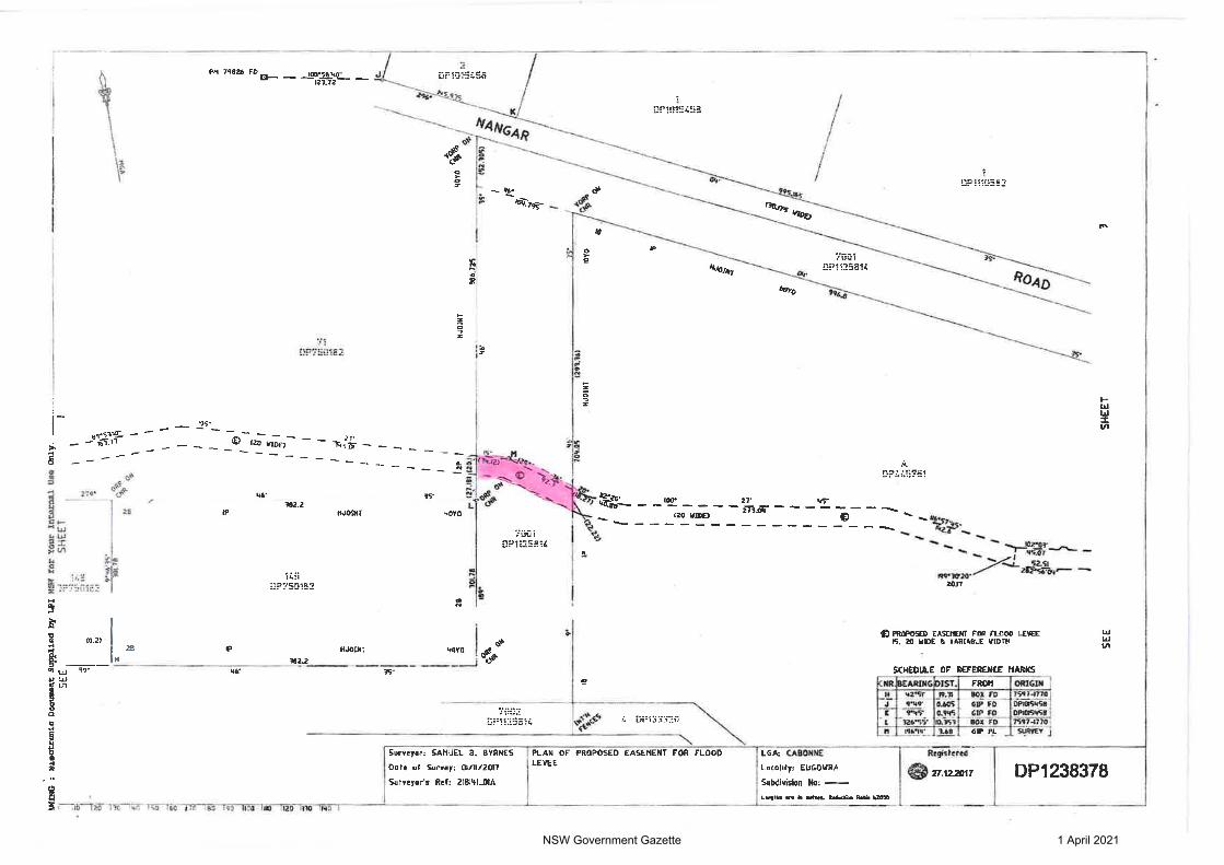
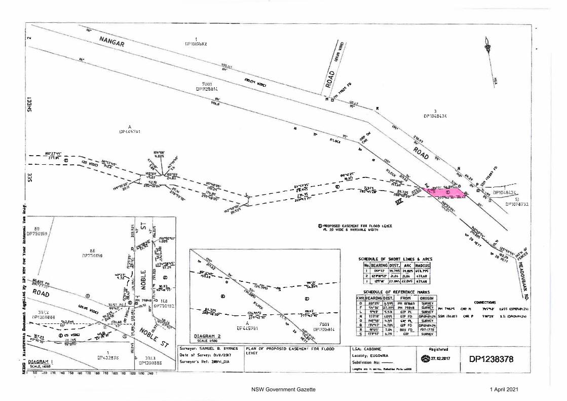