gold and copper deposits near payson, arizona
TRANSCRIPT


CONTENTS
INTRODUCTION AND ACKNOWLEDGMENTS . . . . _
LOCATION AND ACCESSIBILITY .•__. ._._._ 3
CLIMATE AND VEGETATION " .__________________ 5
GENERAL GEOLOGY "_ . , 8Physiography . .____ 8
STRATIGRAPHY ~-----------------.------- 9Metamorphic Rocks ~______________________ 9
Sedimentary Rocks ------------ 12Igneous Rocks. 17
Intrusive Rocks. .. .__________________ 17Extrusive Rocks .. .__ 17
STRUCTURE . . . .__. . 21
GEOLOGIC HISTORY__" . . .__ 22
ECONOMIC GEOLOGY .. . 24-Mineralogy . . 24-
Gold Minerals. . ~24_
Silver Minerals. . 24-Lead Minerals ~ 25Copper Minerals . 25Iron Minerals . .__ 27Gangue Minerals ~----- 27
Ore Deposits . . . 28History of Mining 28Gold Veins._________________________ _ 30Copper Deposit"- . . 31Placers __. 32Enrichment 33Age and Probable Origin. . 34-
MINES AND PROSPECTS . . . . .__ 3rOx Bow Mine 37Gowan Mine • 39Golden Wonder Mine. . 40Single Standard Mine ~__ 40Zulu Mine . 40Bishop's Knol! Mine ~ . . 41Silver Butte Mine . . 42Prospects ~ . . . .. . . 42
PRACTICAL DEDUCTIONS . .. ----..-----....---_. .... .... 4-3

GOLD AND COPPER DEPOSITS
NEAR PAYSON, ARIZONA
By CARL LAUSEN AND ELDRED D. WILSON
INTRODUCTION AND ACKNO\VLEDGMENTS
The following report is based upon an investigation made for thepurpose of obtaining from the Payson region, or Green Valley miningdistrict, geological data. that might be of interest to mining men, prospectors, and investors. These data were obtained during a two weeks'visit in July, 1923, and a brief visit in March, 192+. The geologicbase was for the most part prepared in 1920, during the course of thereconnaissance survey for the new geologic map of Arizona; and thetopographic base map used for this region was the United States Geological Survey's Verde quadrangle topographic sheet, surveyed in 1885,on the scale of about four miles to the inch, with a 200-foot contourinterval.
Grateful acknowledgments are due Mr. Wm. Craig, of Payson, forearly historical information upon the district. To Mr. Arthur Boozer,Manager of the Atlantis Mining Company, Hon Jno. McCormack,of Gisela, Mr. E. B. Simanton, Mr. W. B. Collom, of Payson, andmany other people of the region, acknowledgments are made for information, hospitality, and courtesy.
LOCATION AND ACCESSIBILITY
The region examined lies in the mountainous northern part of GilaCounty, in a portion of the area topographically mapped in 1885 bythe United States Geological Survey as the Verde quadrangle, and iswithin the Tonto Basin and East Verde drainages.
Payson, which is known chiefly as a summer and hunting resort, isthe principal town of the region. It was once a thriving mining center,but now depends for the support of its 214 inhabitants mainly uponthe cattle industry, and only very slightly upon mining. It is locatedabout ninety miles by road from the Arizona Eastern Railroad points,Globe and Miami, or about fifty-five miles north of Roosevelt Dam,and is reached from these places by a very good highway over whichstages run three times a week. The new Apache Trail provides a good

4 ARIZONA BUREAU OF MINES
outlet by way ·of Roosevelt to Mesa and Phoenix, about 115 and 135miles from Payson,- respectively. The Santa Fe Railway points, Winslow, and Flagstaff, about ninety miles to the north-east and north, arealso reached from Payson by road. A new highway, now under construction, will cross Fossil Creek to connect the Payson region with CampVerde and Clarkdale.
FllI:I5sfoff'
o CON
1/10
Fig. I.-Index map showing area covered by this report.
At present the nearest shipping point is Globe, on the Arizona EasternRailroad. When better roads are built to Winslow and Flagstaff, ship"ments may perhaps be made ;ldvantageously from those points on theSanta Fe. Likewise, the completion of the highway to Clarkdale will

GOLD AND COPPER DEPOSITS 'NEAR PAYSON, ARIZONA
provide still ahothet olItlet on the :Santa Fe, and Clarkdale will ~then bePayson's nearest .shipping-point. The proposed newraihoad fmm Clarkdale down the Verde Ril'er to PJioenix; if built, will probably:be withinthirty miles of Payson.
If electrical power is ever needed' in the PaysOh" district; it couldprobably be obtained from the Fossil-Creek power plant; which is abouttwenty-five miles distant by air~line, 01' from the Roosevelt power plant,which is abortt forty-five miles distant by air-line.
CLIMATE AND VEGETATIONInasmuch as it lies in the Mountain Region of Arizona, yet ,at cleva
tions varying between 34-00 and 5000 feet, th~Payson region has "1diversified climate much less i'ntensely'hot and dry than the desert regions o~ Arizona. The temperatllre ~nd, .to a considerable extent, theprecipitation vary with .the elevation.. .
For Payson, the United States\V~~ther Bureau records show that in1915 the annual mean temperature was 53.4 degrees; the highest tem-:perature was in August, 95 degJ:ees; and the .lowest temperature wasin December, six degrees above zer~. The total predpitation for thatyear amounted to 25.4-8 inches, ,with January (4-.7 inches) the wettest,and October (0.1S inch) the driest month.. For that year the totalsnowfall was thirty-two i~ches. Fo.r the year 1919 the tota.! precipitation amounted tq 30.56 inches;', ,th~ we~tes1; month wa~ 'July, with6.33 inches; the dri~st J;Tlonth wa& June, ,,~ith, 0.00 inch; . apd th~
total snowfall was forty-six inches. ," " ',.There is, then, a rainy season du~'i~g the mo~ths ~f j~lly alid August
when showers, some of which are torrential, fall nearly every day j anda wet season from December to J\1arch inclusive, when considerable rainand snow fall. Prospecting or mining operations should not, however,be greatly hampered by climatic conditions. Although during the rainyseason the roads of the region may be difficult to travel, they seldombecome impassable j and only those leading out across the MogollonPlateau are ever blocked by snow.
During even the drier months of the year the greater number of thecanyons contain springs or small running streams of water sufficient formost domestic purposes. In the town of Payson very fine water is obtained from shallow wells.
In the Payson region are three major zones of plant life;* they arethe montane forest, the oak-juniper zone, and a zone of desert shrubswith foothill grasses.
*These vegetational data were largely supplied by Dr. J. V. G. Loft:field, formerlyof the Desert Botanical Laboratory of the Carnegie Institution of Washington.
6 ARIZONA BUREAU OF MINES
The highest, the montane forest, occurs on the Mogollon rim, andto the north and east of Payson at elevations usually over 5600 feet~bove sea level. It constitutes part of the Tonto National Forest, whichin turn is a unit of the so-called Mogollon Forest, said to be the largestforest in North America. It is here represented almost exclusively byyellow pine. Along streams are found aspens, alders, river-birch, andmany other species, and in open places the Rocky Mountain oak. Theeconomic trees are the yellow pine, and, to a lesser extent, the oak.
A sawmill, located about twelve miles east of Paywn, is capable offurnishing almost any amount of timber that might be needed for use
in mining operations.Next below the montane forest is the oak-juniper zone, usually at
elevations over 4600 feet. Its representatives are (Juniperus mottospermaand other species of juniper); a tall oak bush (Quercus undulata);hairy sumac (Schmaltzia sp.); deerbush (Ceanothm fettdleri); barberry (Berberis fremo1ttii) and other plants of lesser prominence.
Below the oak-juniper zone is the zone of desert shrubs and foothillgrasses. The shrubs are largely catsdaws (Acacia constricta, A. greggii,Mimosa biuncifera, etc.) associated with more or less mesquite (Prosopisjuliftora velutin-a) , palo-verde (Parkittsonia microphylla and P. torre)'ana), garanbullo (Condalia spathulata), and several species of Lycium.Many cacti are represented, such as chollas and prickly pears. In thecanyons and washes of this zone, and extending into the zone above, arealso found cottonwood, hackberry, black walnut, and sycamore. Thefoothill grasses are little redstems, Texas timothy, several kinds of grama,
mesquite grass, needle grass, and many others.

GOLD AND COPPER DEPOSITS NEAR PAYSON, ARIZONA 7
GEOLOGIC MAP OF THE:PAYSON DISTRICT, ARIZ.
Scale? ~ TMi les19~4.
Quaternar~ CarbonIferous D£1Io nia n ~:;;:;:;;::;:;--;::;;:::;;.Fr::;:;:"-:;=';::;==:;:;-r=7'i'~~ I
GU-~~~mGravel. Redwall 59c.amore Gr. Youn9er Pinal Diorite6< Sands Lime.tone Sandsft>ne Schist Schisf
-:M IN ES:-. GOWAN 3.GOLDEN WONDER .s; ZULU.,sINGLE ,sT,qNDJ'lRD 4. OX BOW 6. BISHOP!s ifNOI-L
7. ,sILVE" BUTTE
Plote T.

GENERAL GEOLOGY
PHYSIOGRAPHY
Physiographically, Arizona is divided into three major regions. Thesewere first designated by Ransome* as the Desert Region on the southwest"the Plateau Region oil the northeast, and the Mountain Regionin between; or, more broadly, as the plateau province and the basinand range province.
The Payson district lies near the northern limit of the mountain beltor region, within a few miles of the great Mogollon Escarpment thathere marks the southern border of the plateau region. The relief of thedistrict varies considerably, both as to intensity and altitude; the precipitous Mogollon Escarpment, the rugged north end of the MazatzalRange, and the deep canyons of East Verde River and Tonto Creek arein extreme contrast to the fairly even topography at Payson and themoderate contour of the floor of Tonto Basin.
The Mogollon Plateau rises gradually from the northwest towardsthe southeast. Some ten or twelve miles north of Payson, where itattains an elevation of abollt eight thousand feet above sea level, it suddenly breaks off with a bold escarpment two thousand feet high. Thisremarkable escarpment, which is locally known as the "rim" or the"mountain," and which is visible for many miles, is thought by some tobe due to faulting; but closer examination clearly demonstrates that it isthe result of erosion that has stripped back the plateau strata. Exposuresreveal a complete, slightly northwestward-dipping section consisting hereof the Permian Kaibab limestone at the top, underlain successively bythe Permian Coconino sandstone, the Permian Supai sandstones andshales, the Devonian-Carboniferous Redwall limestone, and the Devonian Sycamore Creek sandstone. Erosional removal of the soft, Supaisandstones and shales faster than the more resistant, Coconino and Kaibabcapping has brought about the cliff-like steepness of the escarpment.The Redwall limestone forms the pedestal of the cliff, and it, togetherwith the Sycamore Creek sandstone, dips regularly under the Plateau.
Farther south towards Payson the Redwall and Sycamore Creek havebeen more or less completely stripped off from the pre-Cambrian graniteand diorite basement, and the latter presents the form of a table-landdissected by the tributaries of East Verde River and Tonto Creek.
To the west of Payson is a rather sudden descent into the canyon ofEast Verde River. This stream, which runs during the whole year and
*RanSOllle, F, L., Bisbee Folio: D, S. Geol. Survey, Geologic Atlas of the D. S.,Folio 112, (Reprint) 1914; Ray Folio, Folio 217, 1923.

GOLD AND COPPER DJ;;POSITS NEAR PAYSON, ARIZONA 9
IS often a raging torrent during the rainy season, heads under the edgeof the Plateau at an elevation of 6500 feet or more above sea level, andjoins Verde River at an elevation of about 2700 feet. In consequenceof its steep gradient and large drainage area, it has cut a canyon throughthe Redwall and Tapeats, and well down into the basement rocks, to anelevation, near the old Gowan Mine, of about 3500 feet.
Southeast of Payson is a fairly regular, but thoroughly dissected slope,extending into the canyon of Tonto Creek. This creek, like the EastVerde, heads under the edge of the Plateau; but, because it has muchlarger drainage area, it has cut even more deeply into the hard, preCambrian granites and schists. The wild rampages of this creek duringthe rainy seasons caused early settlers of the district to give it the Mexican title of "Tonto" (crazy).
South of Payson, beginning at a point a short distance above the OxBow Mine, is a regularly dissected slope extending into the valley ofRye Creek, which is a tributary of Tonto Creek. This valley, primarilyof structural origin, owes its present broad, open character to a moderately dissected filling of Pliocene lake beds plus a mantle of Quaternary gravels. The same filling, together with its characteristic topography,continues northwestward over a low divide and occupies a portion of EastVerde Valley between the mouth of Rock Creek and a point a few milesnorth of Simanton's ranch.
The west slope of the valley of Rye Creek breaks rather suddenlyinto the precipitous front of the Mazatzal Range. This range of mountains, structurally of the Basin and Range type, and one of the longestin Arizona, ends rather suddenly with North Peak, 7700 feet above sealevel. From there it slopes rapidly, in a distance of about four miles,downward to! the East Verde River, 3500 feet above sea level. Its boldnorthern and eastern fronts are due primarily to faulting and secondarilyto erosion. Since its higher portions receive an unusually large amountof precipitation, torrential in the summer months, its slopes are deeplyand intricately dissected into extremely rugged topography.
STRATIGRAPHYMETAMORPHIC ROCKS
The oldest rocks in this district consist of a series of sencltlc andquartzitic schists, schistose grits, quartzites, and conglomerates. Thisseries may he divided into two groups: One which has suffered intensedeformation and which has been thoroughly recrystallized; and a youngergroup, consisting chiefly of quartzsites and greenstones which are relatively less deformed and have been only slightly altered by recrystallization.

10 "1RIZONA BUREAU OF MINES

GOLD AND COPPER DEPOSITS NEAR PAYSON, ARIZONA It
The older of these two groups of rocks, the schists, extends in a northeast direction from the :Mazatzal Mountains eastward to where it is cov~
ered by Paleozoic sediments. This belt of schists is over 10 miles widein places, but only a small portion occurs on the map included with thisreport. The planes of schistosity strike northeast and usually dip atsteep angles. Where seen along Tonto Creek the schists have considerable lithologic variety. They include sericite schist, greenstone schist,and hornblende schist. At the Bishop's Knoll Mine the hornblendeschists are the most common variety. The sericite schists are pale todark brown in color with a decidedly satiny luster. Parting faces ofthis type of schist are rather rough, due to the large grains of quartz,and to small pebbles. They are usually covered by thin foils of mica.
Under the microscope a thin section of the sericite schist is found toconsist largely of quartz grains surrounded by foils of sericite. The rockalso contains considerable magnetite, some chlorite, and a few grains ofvermilion-red jasper. The greenstone schists consist of quartz, sericite,and chlorite, with some calcite, magnetite, and scattered crystals ofrather acid plagioclase. The greenstone schist also contains small masseswhich seem to be the groundmass of a rather basic igneous rock, andwhich consist almost entirely of small plagioclase laths, a few shredsof chlorite, and considerable magnetite dust. The hornblende schistconsists largely of green hornblende and quartz, together with someneedles of apatite, a little magnetite, and epidote. The hornblende islargely altered to chlorite.
In part, these schists were derived from sedimentary rocks. Theoccurrence of small grains of jasper, pebbles of quartzite and chert, aswell as vein quartz, suggests that the sericite schists were originally Sediments that have since been deformed and recrystallized. The hornblendequartz schist may ha\re been derived from sediments, but the greenstoneschists certainly were not. The finding of unaltered fragments of igneousrocks suggests that this type of schist was formed from moderately basic,perhaps andesitic, flows, breccias, and tuffs.
vVith regard to their age, but little can be said of these rocks otherthan that they are probably pre-Cambrian. They are not overlain byCambrian sediments, but have been invaded by plutonic masses ofgranite and diorite which are themselves believed to be of pre-Cambrianage. Until more detailed work has been done in Arizona it will beimpossible to assign these schists to any definite part of the pre-Cambrian.They are, therefore, tentatively correlated with the Pinal schists of theGlobe district.*
*Ransome, F. L., Geology of the Globe Copper District, Ariz.: U. S. Geol.Survey J'rof. Paper 12, p. 23, 1903.

12 ARIZONA BUREAU elF MINES
The younger group of metamorphic rocks occurs along the east baseof the Mazatzal Mountains from Deer Creek northward to the EastVerde River. These rocks have been described by Ransome* as follows:
"At the base of the sediments is a brick-red detrital rock made upof !lakes of schist in an abundant matrix, apparently also composed ofminute schist particles with an occasional grain of quartz, .•• Overlying it without any sharp line of demarcation is a conglomerateabout 2 feet th:ck, with sparse pebbles of rhyolite and red jasper asmuch as 5 inches in diameter. The conglomerate in turn grades upward into quartzite. The quartzite is very hard and vitreous and isgenerally reddish or brown. Much of it is banded parallel with thebedding planes."
In another traverse up the North Fork of Deer Creek Ransomei"describes these sediments again as follows:
"The first rock to be seen in ascending the ravine is a large bodyof quartzite folded into a sharp antic1ineand apparently faultedagainst shales on the northwest. These shales resemble nothing I hadpreviously seen in Arizona. They are gray-green, weathering yellow,fairly hard, and only moderately fissile .••."
On the south side of the East Verde River the writers observed athick series of shales of a dark green to chocolate-brown color. Theseshales are uniformly fine-grained, showing no bedding planes, and arehighly indurated. Apparently over these shales is a great thickness ofgreenstones which in turn is succeeded by massive feldspathic quartzite,conglomerate, and then by alternating gray and banded red-brown quartzite. The uppermost members of the series are beyond the limits of thearea included in this report and were not studied. The total observedthickness including the greenstone is probably over two thousand feet.
These highly indurated sediments are cut by numerous dikes of graniteporphyry, and by masses of hornblende diorite. This dioritic rock isprobah'y the same as the harnblende diorite in the vicinity of the OxBow Mine, which is believed to be pre-Cambrian j and the sedimentsare therefore also thought to be of pre-Cambrian age.
SEDIMENTARY ROCKS
§ycamore Creek S.mdst01te: As is shown on Plate I, this formationoccurs as isohted remnants south and southEast of Payson, while to thenorth is a large area partly overlain by the Redwall limest()ne.
The Svcamore Creek sandstone is generally dull, reddish-brown incolor, although some buff colored beds are also present. The rock ismade up of a coarse quartz sand cemented chiefly by oxides of ironand carbonate of lime. Cross-bedding is locally common and then thestratification is not well defined. The bedding planes are more apparenr
*Ransome, F. L., Some Paleozoic Sections in Arizona and Their Correlation:U. S. Geol. Survey Prof. Paper 98, p. 158. 1916.
tRansome, F. L., op. cit.

GOLD AND COPPER DEPOSITS NEAR PAYSON, ARIZONA 13
on weathered surf:Jres than in hand specimens. The rock is traversedby numerous joints, and weathers as steep bluffs. Pebbly layers arccommon, but the pebbles rarely excetd one inch in diameter, and consist of qU:lrtz, quartzite, and some jaspers. The upper part of this sandstone in thl' area cO\'er"d by this rtport has been largely removed byerosion, and where the formation is overlain by the Redwall limestonethe thickness is seldom over 150 feet.
When a reconnaissance survey of this region was made for the geologicmap of Arizona this sandstone was correlated with the Upper CambrianTapeats sandstone of the Grand Canyon section. Within the last year,]lOwever, Drs. Chas. Schuchert and A. A. Stoyanow have found thelayers of finer-grained material between the pebbly beds to contain bonyplates of fresh-water fishes. These fossil fishes Dr. Stoyanow* statesare undoubtedly of Upper Devonian age. A thorough examination ofthis material will probably lead to the correlation of the Sycamore Creeksandstone with the sandy beds at the base of the Temple Butte limestonein which Noblet found fragmentary remains of Bothriolepsis, an UpperDevonian fish.
A manuscript in which this horizon and its fossil remains will bedescribed in detail, is now in course of preparation; and Dr. StoyanowwiJl propose the name Sycamore Creek sandstone for this formation.
Resting with apparent conformity on the Sycamore Creek s.mdstoneare thin-bedded, Raggy limestones. A small area of this limestone isshown near the northern edge of PIate 1. The lower members of thisformation are somewhat sandy and argillaceous, and these impure bedsgrade npward into dense, light-gray and pink limestone. These lowerbeds, usually less than a foot thick, contain but little cherty material, andmay in part be dolomitic. Above them the limestone is slightly darkergray, compact, and in beds two to three feet thick separated by thinpartings of shale.
In these limestones Stoyanow found the following Upper Devonianfossils: Spirifer whitneyi var. animasensis, Pachyphyllum woodmani,Cladopora sp. The occurrence of this variety of Spirifer, according toStoyanow, suggests a closer relationship of this hcinzon to the Ouraylimestone of Colorado than to the Martin limestone of southern .'\rizona.
Redwa!l Limestone: Immedi<Jtely above the thin-bedded Devonianlimeswnes are rather pure limestones of Mississippian age, in whichStoyanow found a typical Madison fauna. The thickness of this formation in the area included in this report is approximately one hundred
*Personal comnlunication.
tNable, L. T., A Section of the Paleozo'c Formations of the Grand Canyon afthe Bass Trail: U. S. Geo]' Survey Prof, Paper I3I·B, p. 52, 1922.

14 ARIZONA BUREAU OF MINES
Plate III. A.-Exposure of' Sycamore Creek sandstone north of Payson.
Plate III. B.-Sycamore Creek sandstone showing details of stratification.
GOLD AND CoppeR DEPOSITS NEAR PAYSON, ARIZONA 15
feet, while in the Mogollon Escarpment the thickness is over 350 feet,showing that the major part of the formation near Payson has beenremoved by erosion.
This formation is correlated with the Redwall limestone of the GrandCanyon. The Redwall limestone as redefined by Noble* is assigned tothe Mississippian by him, while the Temple Butte limestone and theMartin limestone are both Upper Devonian. The limestones near Paysonare unfossiliferous, and, although traces of organic remains were found,they were too fragmentary for determination. It is the writers' beliefthat these limestones are the equivalent of the lower part of the Redwalllimestone, and they are here correlated with that formation.
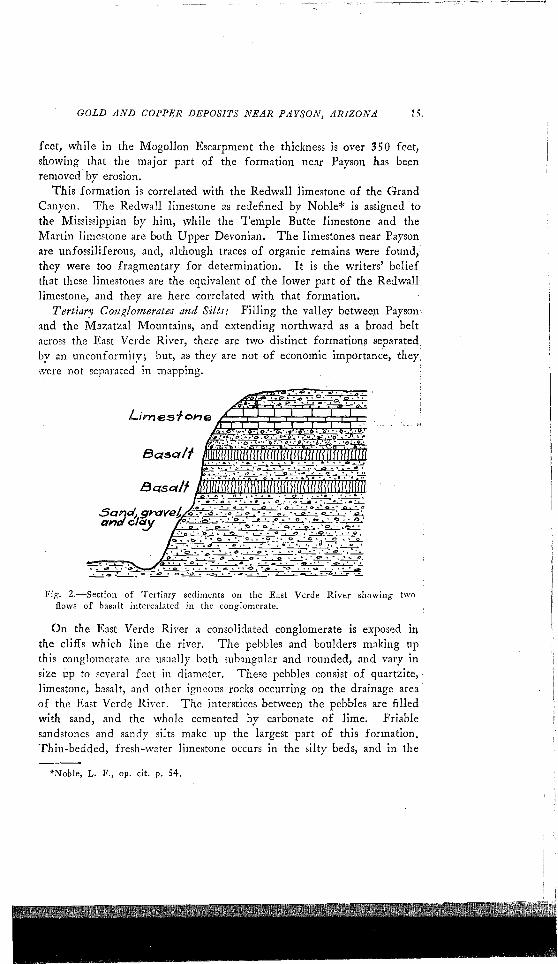
Tertiary Co7tglomerate~ and Silts.. Villing the valley between Payson'and the Mazatzal Mountains, and extending northward as a broad beltacross the East Verde River, there are two distinct formations separated,by an unconformity; but,as they are not of economic importance, they:were not separated in mapping. .
BasalT
Fig. 2.-Section of Tertiary sediments on the East Verde River showing two/lows of basalt intercalated in the conglomerate.
On the East Verde River a consolidated conglomerate is exposed inthe cliffs which line the river. The pebbles and boulders making upthis conglomerate are usually both subangular and rounded, and vary insize up to several feet in diameter. These pebbles consist of quartzite,limestone, basalt, anel other igneous rocks occurring on the drainage areaof the East Verde River. The interstices between the pebbles are filledwith sand, and the whole cemented by carbonate of lime. Friablesandstones and sandy silts make up the largest part of this formation,Thin-bedded, fresh-water limestone occurs in the silty beds, and in the
*Nohle, L. F., op. cit. p. 54.

16 ARIZONA BUREAU OF MINES
Plate IV. A.-Tertiary sediments southwest of Payson.
Plate IV. B.-Old stope at the Gowan Mine. These juniper stulls have beenstanding for over forty years. Photo by Chas F. Willis.

GOLD AND COPPER DEPOSITS NEAR PAYSON, ARIZONA 17
cliff sections along the East Verde River two basalt flows were intercalated in the conglomerates. A section illustrating these relations isshown in Fig. 2.
The material of which this formation is made up' was deposited in atemporary lake formed by the damming of the East Verde River byextensive flows of basalt. These basalts appear to have come from somevent to the north or northwest of Payson, and were probably extrudedduring the first period of basalt eruption, which Robinson* has shown tobe Pliocene. This formation is therefore probably Pliocene, and mayin part be younger.
Quatemary Gravels: Resting on the fresh-water limestones, conglomerates, and silts described above are unconsolidated gravels and sands. Thepebbles in this gravel are similar to the pebbles in the underlying conglomerate, both in rock composition and texture, and were probably derived from the same source. The two formations differ decidedly inthe degree of induration; but on weathering resemble each other soclosely that a separation in the field is impracticable. As neither of theseformation is of economic importance, they were not separated on themap accompanying this report (See Plate I). That they were depositedat different times, however, and possibly with a decided time intervalintervening, is clearly shown by their relative positions; the gravelsoccupy the ridges, while where the streams have cut through the gravels,the older formation is exposed in the bottoms of the gulches. In thedeeper gulches the contact between the two formations is :\n irregularone, with many cuts in the underlying soft silts. These cuts are filledwith gravel and sand, and the trenching in these silts suggests old streamchannels. No fossils were found in this formation, but it is tentativelyassigned to the Pleistocene.
IGNEOUS ROCKS
The igneous rocks in the vicinity of Payson consist of two pre-Cambrian plutonic masses, various basic and acidic dikes, and a greenstone(al tered andesite) intercalated in the younger schist series. There areapparen tly no Paleozoic or Mesozoic igneous rocks in this district; but,in the late Tertiary conglomerates and silts are some flows of basalt andassociated tuffs.
INTRUSIVE ROCKS
Granite: Plutonic masses of coarse-grained red granite occur to thesoutheast and east of Payson, extending for many miles to the east ofthe limits of the area included in Plate 1. To the southeast the graniteinvades the pre-Cambrian schist series, while to the north and northeast
*Robinson, H. H., The Son Franciscan Volcanic Field, Arizona: U. S. Geo!.Survey, Prof. Papel' 76, p. 92, 1913.

18 ARIZONA BUREAU OF MINES
the granite is coyered by the Paleozoic formations. The granite is cutby numerous fine-grained aplitic dikes of a pink color and containingessentially the same minerals as the granite. The rock weathers to acoarse, granitic soil consisting of quartz and feldspar, and exposures ofthe fresh rock were not seen.
Mcgascopically, the rock is pink in color, has a coarse, granitic texture,and a uniform grain, and consists essentially of potash feldspar andquartz. Ona fresh fracture, sparkling, cleavage faces of the feldsparmay be seen; and a few small flakes of a chloritic mineral, as well asoccasional grains of magnetite, are ~vident.
Under the microscope, the rock is seen to consist essentially of microcline and quartz, together with a little orthoclase and albite. A fewshreds of green hornblende and some muscovite are present, and asaccessory minerals magnetite and zircon were identified. An elongatedblue mineral occurs in a grain of quartz, but the optical properties couldnot readily be determined because of its small size. The quartz in thisrock occurs as clear anhedral grains with irregular trains of inclusionslike a string of beads. The microcline shows the typical, gridiron structure due to a combination of twinning in accord with the albite andpericline laws. Cleavage is sometimes seen, but usually the mineral ilclouded with kaolinitic dust. A few small, subhedral grains of orthoclase with the typical Carlsbad twinning occur in the rock, and somealbite was found. The m1all amount of hornblende present was of thegreen variety, and occurred as ragged shreds between other minerals. Itis strongly pleochroic and alters readily to a chloritic substance. Muscovite is rare, as is also zircon. The alteration products consist of chlorite,kaolin, and sericite.
The texture is holocrystalline and hypidiomorphic, with a tendencytowards equigranularity. The albite and orthoclase were among theearlier minerals to crystallize out, and therefore have their boundariesmore or less well developed; but neither the microcline nor the quartzshows any well-defined crystal boundaries.
The gran ite, which intrudes the pre-Cambrian schists, and is thereforeyounger than them, is itself intruded by the hornblende diorite just westof Payson. It has the Sycamore Creek sandstone of Upper Devonianage resting upon its eroded surface. It is the oldest igneous rock inthe district, and is probably the same as the Ruin granite of the Globedistrict described by Ransome.*
Homble1lde Dio;<ite: This intrusive rock is distributed in a northv\'es~-scll1theast trending belt, immediately west of Payson, and extendsfrom th~ Gowan Mine on the East Verde River to the BiShop's Knoll
"R 'l1Some, F. L., Geology of the Globe Copper District, Ariz.: U. S. Geol. SurveyPro;'. P"pcr 12, pp. 73-75, 1903.

GOLD AND COPPER DEPOSITS NEAR PAYSON, ARIZONA 19
where It intrudes the schist. Along its east boundary it intJ:l,ldes th.~granite described above, and to the southwestward is covered by the)ateTertiary sediments. The rock weathers to an olive-drab soil whi~h 'onclose examination is found to consist of altered feldspar and hornbl~;de'"
The rock is cut by numerous basic and acidic dikes, and near the Singl~'Standard Mine by a dike of fine-grained hornblende diorite. . .
The rock is generally of a dark gray color, but locally, as at theOx Bow shaft, is much lighter colored due to the local abundance. pf'feldspar. In a hand specimen the rock is of a coarse-grained granitictexture and is composed chiefly of hornblende and feldspar. The h~r~
bIende is usually in larger crystals than the feldspar, but the constituentminerals seldom exceed a quarter of an inch in length. With the' aidof a hand lens the feldspar is found to show abundant polysynthetictwinning, and is therefore plagioclase. The hornblende is nearly ,blackand shows the perfect prismatic cleavage intersecting at 12+b. Occasionaigrains of quartz and magnetite may also be seen. .
Microscopically, the rock is composed essentially of plagioclase feldspar and hornblende, together with a little quartz and orthoclase andrarely a little biotite. As accessory minerals, magnetite, apatite, andzircon were observed. The plagioclase, determined by the statisticaimethod, was found to be labradorite; but sections of the mineral parallelto the albite twinning plane show a zonal structure, so the outer portionof the mineral may! be basic andesine. The mineral is usually cloudydue to minute inclusions of kaolin, an alteration product, especially alongcleavage lines. The hornblende is of the dark green variety, and isstrongly pleochroic. The prismatic cleavage is very pronounced. Thehornblende often contains numerous grains of magnetite, especially nealthe center of the crystals, and is unusually free from alteration. Thequartz occurs interstitially between the hornblende and labradorite, orbetween different grains of feldspar. The quartz is clear, and' containsonly a few minute crystals of apatite as inclusions. The magnetite occursas irregular, more or less rounded grains, sometimes abundant in' thehornblende. Apatite is present as short, stout, and well-formed crystals,occasionally partially enclosed by magnetite or by hornblende; and minutecrystals were also found in both the quartz and labradorite. Biotite israre, and the few sheds found were of the deep brown variety. Thealteration products are not abundant, and consist chiefly of kaolin, achloritic mineral with anomalous interference colors which may in partbe antigorite, and a few grain> of epidote.
The texture as seen under the microscope is holocrystalline, hypidiomorphic, and granular, with the plagioclase and hornblende showingpartial crystallographic outlines. Very often the hornblende occurswith ragged outlines and partially enclosing other minerals, especially'
20 ARIZONA BUREAU OF MINES
magnetite and apatite. The quartz was undoubtedly the last mineralto crystallize, and occurs interstitially between other minerals.
This plutonic mass cuts the granite and the schist, and is thereforeyounger than either of these formations. Just west of Payson the Sycamore Creek sandstone rests unconformably on the diorite, which is clearlypre-Cambrian; but the time relation of the diorite to the greenstonesintercalated in the younger schist series is not known, for the two rocksue nowhere in contact with each other. However, since this series ofsediments does not show any contact effects, it is believed that the dioriteis the older of the two.
Basic ant! Acidic Dike,,: Cutting the granite and the hornblendediorite are numerous dikes, both basic and acidic in composition. In the,·icinity of the Ox Bow Mine these dikes generally have an east-wes~
or a northeast-southwest trend; but on the western part of the claimsof the Bishop's Knoll Mining Company the basic dikes trend nearlynorth-south, while the acidic dikes have an east-west strike.
The basic dikes with a north-wuth strike may be divided into twogroups, one of which is earlier than the acidic dikes and one of whichis later. The members of the older group vary in composition fromrocks containing about equal amounts of hornblende and plagioclase torocks consisting almost entirely of coarse-grained, interlocking crystalsof hornblende. The younger basic dikes are usually fine-grained, andconsist largely of hornblende and plagioclase, with accessory apatite andmagnetite. At the Ox Box Mine the basic dikes are hornblende porphy~
rites that consist of porphyritic cry,tals of green hornblende in a groundmass of hornblende and plagioclase feldspar, near andesine in composition, together with accessory apatite and magnetite. Acidic dikes ofgranite or granite porphyry cut the basic rocks. The dikes of graniteporphyry are usually fine-grained, only slightly porphyritic, and consistof quartz, orthoclase, some acid plagioclase, and a little biotite and hornblende altering to chlorite. Acidic dikes of the same general composition also cut the greenstones on claims of the Silver Butte MiningCompany.
Although these dikes occur within a short distance of exposures ofSycamore Creek sandstone, they were nowhere observed cutting thisformation, and are probbly of pre-Cambrian age. They are, however,definitely later than the hornblende diorite.
EXTRUSIVE ROCKSGreeltStolZe: The oldest extrusive rocks found in the area covered
hy this report occur as greenstones which form a rather continuous beltalong the foot of the Mazatzal 1\10untains. The greenstones occur inthe younger schist, underlain by highly indurated shale and overlain byquartzites. These greenstones were originally andesitic flows, breccias,

GOLD AND COPPER DEPOSnS NEAR PAYSON, ARIZONA 21
and tuffs, and have a thickness of over one thousand feet; but in partthis thickness may result from duplication due to faulting.
Examined microscopically, these rocks were found to consist largelyof chlorite, epidote, and feldspar, together with a little kaolin,calcite;st>condary quartz, and deep red scales of hematite. The larger porphyritic crystals of plagioclase are usually in part replaced by epidote, whilethe second generation of plagioclase in the groundmass surrounded bychlorite is only slightly altered. The small crystals of feldspar showdistinct flow structure. No original ferromagnesian minerals were found,and the rocks were probably originally andesites.
These rocks are unconformably overlain by the Sycamore Creek sand...stone of Uppt>r Devonian age, and are considered by the writers to be'pre-Cambrian.
Olivine Basalt: Flows of basalt occur along the East Verde Riverintercalated in the conglomerates and silts of the late Tertiary. The'rock is dark colored and rather fine-grained; and with the aid of a handlens olivine and striated plagioclase feldspar may be readily identified.These flows are unimportant economically, but have been discussed above'in connection with the sedimentary rocks. They are shown diagramat-1
ieally in Fig. 2.
STRUCTUREMost of the area covered in this report consists of massive igneom
rocks, such as the old granite and the hornblende diorite. In the south-'east corner of the area, the schists which have been correlated with thePinal schists of the Globe region consist of highly folded and contorted'beds of sediments. The younger schists at the base of the Mazatzal'Muuntains, although highly indurated and partially recrystallized, showdistinct bedding-planes, especially in the quartzites. On the North Fork'of Deer Creek Ransome* found these quartzsites to have been foldedinto an anticline with steeply dipping limbs. These same beds along theE.~st Verde River have a fairly uniform dip of about 20 0 to 25 0 to thenorthwf'st. The Paleozoic rocks lie nearly horizontal, and show little'or no folding.
Faulting has been more important than folding in this region, andall the veins ohserved occupy fault fissures. These faults vary in strikefrom northeast to northwest. In the vicinity of the Bishop's Knollthere are a number of dikes trending generally north-south or east-west.l\1any of these dikes occupy fault fissures, and, along some of them,faulting has taken place after the intrusion of the dikes. This movement has often thoroughly crushed the rock of which the dikes arecomposed.
*Rallsonle, F. L.) Some Paleozoic Sections in Arizona and their Correlation: U.S:.Geol. Survey Prof. Papel' 98, p. 158, 1916, See figure 13,

22
E
ARIZONli BUREau OF MINES
,GEOLOGIC HISTORY
Pre-Cambrian: The oldest 'ro'(Js of the district, namely the seriesof sericitic,' greenstone, hornblende, and quartzitic schists, schistose grits,quartzites, and conglomerates, constitute avery interesting and intricate;mcient record. Unfortunately, however, as is so often true of theolder pre-Cambrian, this record 'is only dimly legible, and is generallyso fragmentary that it is very difJicult to read it.
Microscopic ,:tudi7s of, these schists sugg<:ost that they were in part ofsedimentary origin, and in part igneous. But, so far, nothing verydefinite is known of the still more ancient basement upon which theyrested, or of the land mass from which the sediments were derived.Fluctuating cycles of long-continued continental and marine sedimentation, accompanied by igneous extrusions, appear to have obtained overWidespread areas. How long deposition continued, or what the totalamount of the great thickness of these older rocks was, is unknown; butthey were ultimately subjected to deep burial, followed by dynamicmetamorphism sufJicient to bring about most of their present state ofrecrystallization and schistosity. This change was accompanied or closelyfollowed by mountain-making movements and the batholithic intrusionof the granite. Next, there ensued a period of long-continued erosion,resulting, probably, in more or less peneplanation, followed by the resumption of the sedimentation cycle and the deposition of the youngerpre-Cambrian series. This series seems to have been laid down duringanother long period of fluctuating cycles of continental and marine sedimentation. Uplift then again occurred; and mountain-making forces,accompanied or closely followed by the intrusion of the diorite andother dikes, acted to produce the second stage of dynamic metamorphism,which recrystallized this younger pre-Cambrian series.
Sometime before the dawn of the Cambrian period there occurreda;lOther extensive uplift during which the pre-Cambrian formations wereextensively faulted and tilted. A long period of vast erosion then ensued, with the result that the strata were eroded into a peneplain markedhere and there, however, with monadnocks of very resistant rocks.
Paleozoic: Whether erosion continued on through Cambrian time,or whether some sediments were deposited then and were comparativelysoon removed, there is no evidence; but the oldest Paleozoic sedimentsfound in the region consist of sandstones whose upper beds containDevonian fossil fishes, as already mentioned. This sandstone seems tohal'e been deposited in part along the shore of a stea(1liy advancing sea,where much of the rounded, coarse, pebbly material was probably derivedfrom the thorough reworking of loose material littered over the old landsurface; and part of it may have been deposited by rivers. The fact

GOLD AND COPPER DEPOSITS NEAR PAYSON, ARIZONII 23
that both the sand and pebbles of the sandstones consis~ .llmost entirelyof quartz and quartzose materials, very resistant to both oxidation andattrition, together with the lack of fresh feldspathic materials, indicatesthat the old land surface probably existed during a time of great aridity;and the characteristic red color of the sandstone is due to iron oxideprobably derived from gossans of mineralized areas of the old land mass.
Neither the Bright Angel shale nor the Muav limestone of the GrandCanyon region appears to be represented in the Payson district. Whetherthey pinch out before reaching this far south, or were removed by preDevonian erosion, has not yet been determined.
No Ordovician or Silurian was found in the Payson region, nor doesthere seem to be evidence that any sediments of those periods wereever deposited there.
The next formation present, younger thal1! the sandstones, is theDevonian limestone. Above it is another limestone series correlatedwith the Redwall limestone of northern Arizona and consisting here ofMississippian and Pennsylvanian strata. These beds are definitely ofmarine origin, and were deposited in quiet waters upon the Cambriancontinental shelf.
Sedimentation probably continued in the region throughout Permiantime, for Permian beds are well represented a few miles north ofPayson, along the Mogollon Escarpment, and on the Plateau; but erosionhas since stripped them from the area considered in this report.
Mesozoic and Cenozoic: Deposition probably progressed on throughthe Triassic, Jurassic, and Cretaceous, and to some extent into the Tertiary, for representatives of these periods are present in the PlateauRegion farther north. However, Tertiary and Quaternary erosion hascompletely stripped them from the Payson region. Some Tertiary sediments are present as local, detrital conglomerates beneath the lava flows,and probably also as part of the valley filling.
The Tertiary period in this region, as in many others of the Southwest, was marked by vigorous erosion, great volcanic activity, and faulting; and it is quite probable that continuations of the lava flows thatstill remain northwest of Payson, west of Pine Creek, and on much ofthe Plateau, once also covered the whole region. Such flows so obstructedthe drainage of the East Verde River and Tonto Creek in Pliocene timethat lakes were formed which are evidenced today in the calcareous andgypsiferous lower beds of the valleys of these streams.
The early Quaternary of the region probably witnessed some basalticextrusions; but, on the whole, the period has been marked by intenseerosion and considerable consequent deposition of detritus in the valleys.

ECONOMIC GEOLOGYMINERALOGY
A considerable number of distinct mineral species occur in this district. Some of them, such as the feldspars and hornblende, are confinedto the igneous rocks, and have already been described. Others, such asepidote or chlorite, occur as alteration products of pre-existing rockminerals, but because of their close association with the ore depositsmay be included in this list. Sulphide minerals like pyrite, chalcopyrite,bornite, or galena are of primary character, and were deposited whenthe veins were formed. These primary minerals were later alteredby oxidation processes to the oxides and carbonates. The minerals inthis list will be described in groups, such as the minerals containingcopper, or silver, or lead; and they will be followed by species thatare of no economic value, but which are usually found associated withthe ores.
GOLD MINERALS
NatAve Gold (Au): Metallic bright yellow flakes in rusty, porousquartz. The gold of quartz veins contains a variable amount of silver,and is always of a lighter color if considerable silver is present.. Smallflakes of gold were seen in the oxidized ores from the Gowan, the OxBow (Atlantis Mining Company), the Golden Wonder, and the Zulumines. Assays of samples of gold are from the Payson district showonly small quantities of silver. The placer gold on the slopes of OxBow Hill varies in size from minute flakes to small, flat nuggets up toa quarter of an inch in length. The nuggets are of a deeper color thanthe vein gold, and probably contain little or no silver. The gold inthe oxidized portions of the veins was probably derived from auriferouspyrite, and this mineral will be more fully described under the ironminerals.
SILVER MINERALS
Native Silver (Ag): Metallic silver-white flakes or wire, but maybe tarnished brown or gray. Wire silver is reported to have been foundnear the surf~ce in the oxidized portion of the ore-shoot at the SilverButte mine. This metal was not seen in specimens collected duringthis examination, and apparently is relatively rare in the district. Small,but variable, amounts of silver occur with gold in the quartz veins, andit is an important constituent of the galena and tetrahedrite ores at theSilver Butte Mine.
Cel'argyrite (AgCI): Usually massive and resembling wax; often incrusts; also known as hornsilver. Color variable, usually grayish green;upon exposure to light, turns violet-brown. The mineral was reported
GOLD AND COPPER DEPOSITS NEAR PAYSON, ARIZONA 25
to have been found associated with native silver in the open-cut workings of the Sih'er Butte Mine. The mineral is rare in this district,and none was seen by the writers.
LEAD MINERALS
GalelM (PbS): Metallic; color lead-gray; usually as crystallinemasses with good, cubic cleavage; intergrown with other sulphides. Themineral was found only at the Silver Butte Mine, associated with pyrite,chalcopyrite, and the oxidation products of lead and iron minerals. Thismineral probably carries some silver.
AttgleJite (PbS0 4 ): The color of the mineral in specimens fromthis district is light to dark gray, and it occurs as a dull-Iustered, crystalline mass surrounding galena. It al.ters to cerussite, the carbonate oflead. The mineral is not common in the district, and was found onlyat the Silver Butte Mine.
Cerussite (PbCO~): Colorless to white or gray, sometimes blue orgreen due to copper salts. The :mineral occurs in crystalline massessurrounding anglesite, the sulphate of lead, from which it was derived.Jt also occurs as colorless crystals in cavi ties. The crystals are glassywith a faint, silvery sheen on the surface. It is rare in the district, andwas found only at the Silver Butte Mine.
lvlassicot (PbO): The mineral occurs as an earthy, yellow powderassociated with other oxidized lead minerals; it is sometimes greenishdue to the presence of copper, or reddish when it contains oxides ofiron. The mineral, rare in the district and not an important constituentof the orcs, was found only at the Silver Butt,= Mine.
Cuprodesclonitt! (+RO.V2 0 5 .H20,R=Pb, Zn, Cu): Color dark brownto black. Occurs as velvety crusts. Copper replaces some of the lead andzinc in th~ molecule. The mineral was found associated with copperore in the Ox Bow Mine and also at the Zulu Mine. It is rare, and notof economic importance.
Wulfenite (Phi11004 ).' Color orange-yellow. This mineral usuallyoccurs as glassy crystals, but the only specimen found in this districtoccurred as scales on a fracture plane associated with cuprodescloizite.The chemical and physical properties correspond to the mineral wulfenite. It was found only at the Ox Bow Mine.
COPPER MINERALS
Cha!copyrite (CttFeS2): Metallic, color brass-yellow; usually massive. This is the chief sulphide in the copper deposits. It occurs associated with bornite on the claims of C. Harrington and also on claimsof W. A. Cain. Chalcopyrite was also seen with pyrite and galena, inthe ore from the Silver Butte Mine. A little chalcopyrite was found with

26 ARIZONA BUREAU OF MINES
pyrite at the Bishop's Knoll. The copper minerals of many of the goldveins were probably derived from chalcopyrite by oxidation processes.
Bornite (Cu5FeS4 ): Metallic; color pinchbeck-brown on fresh fracture; tarnishes readily to peacock colors. The mineral was found onlyon claims of VV. A. Cain. Here it surrounds grains of chalcopyrite.The mineral is probably primary, but may have been deposited by descending acid solutions.
TetrahedritfA (CuSSb2S7 ): Metallic. Color lead-gray; usually massive. This mineral is the chief constituent of the ore in the SilverButte Mine, and is reported to carry considerable silver. The tetrahedriteoccurs in a gangue of calcite and quartz. In polished surfaces, the mineral was found as irregular grains in galena.Covellite (CuS)): Metallic; crystals usually are thin, hexagonal plates;color indigo-blue. Turns purple when moistened. Covellite occursas a microscopic constituent of the ores in specimens from the SilverButte Mine, in specimens from W. A. Cain's claims, and probablyelsewhere. At the Silver Butte Mine it replaces galena, chalcopyrite,and tetrahedrite. At Cain's claims the mineral replaces bornite. Thecovellite in these specimens was formed by supergene enrichment.*
Chalcocite (Cu2S): Metallic; dull when tarnished; color dark leadgray to black when earthy or tarnished; usually massive. The mineraloccurs in a vein at the Bishop's Knoll. In other parts of the district itis found as a microscopic constituent of the ores, especially in the orefrom the claims of W. A. Cain. The mineral is supergene in origin,and is not important economically in the Payson district.
Malachite (CuCOsCu( OH)2): Dull to glassy; color bright green i
usually radiating-fibrous. This green basic carbonate of copper wasfound in practically all the deposits examined. At the Silver Butte Mineit occurs as stout, prismatic crystals embedded in porous quartz. In thegold-quartz veins it occurs in small, radiating-fibrous masses associatedwith limonite and chrY80colla, and occasionally with azurite.
Azurite (2CuC0 3 .Cu(OH)2): Glassy to dull; color deep azureblue. Crystals. are rare in this district and the mineral occurs only ascrystalline masses at the Silver Butte Mine, at the Golden Wonder, andat the Bishop's Knoll. Like malachite, it is associated chiefly with earthylimonite.
Chrysocolla (CuSiO g .2H20): Dull or waxy to glassy; color bluishgreen to 'sky-blue. Chrysocolla was found at all the properties containing copper minerals, and is usually associated with limonite, quartz, andmalachite. It is not an important constituent of the ores.
*A term applied to ores or ore minerals that have been formed by generallydescending waters. (Ransome, F. L., Prof. Paper 115, U. S. Geol. Survey).

GOLD AND COPPER DEPOSITS NEAR PAYSON, ARIZONA 27
Diopta.re (H2 CuSi04 ): Glassy. Color emerald green; usually ascrystals. This mineral was found at the Ox Bow Mine as small, prismaticcrystals on limonite, and associated with malachite and chrysocolla.
IRON MINERALS
Pyrite (FeS2 ).· Metallic; color pale brass-yellow; usually as crystalsin the quartz veins, but also as crystalline masses in the lead and copperores. May tarnish to brass-yellow, but is harder than chalcopyrite. Inthose quartz veins that have been mined to the ground-water level, pyriteis the most important constituent of the ore, and, since the ore is notfree milling, the gold probably occurs in this mineral. It is usuallyfound in the quartz veins with chlorite. In the lead and copper deposits it occurs with the sulphides of those metals.
Hematite (Fe2 0 3) : Dull (usually) to metallic; color brick-red todark-red; dark gray when metallic; usually earthy in this district. Themineral occurs at all the deposits examined and is especially importantin the gold veins, where it is associated with limonite and quartz andoften carries flakes of free gold. This is one of the most importantminerals in the district, as where this mineral is abundant the gold valuesare higher.
Limonite (2Fe2 0 8 .3H20): Dull; color varies from ocher-yellow todark brown. Limonite is one of the most important constituents of theoxidized portions of the gold veins. Gold occurs in this limonite insmall flakes; and the more abundant the limonite, the higher is the goldcontent of these veins. In the Ox Bow IVline, limonite occurs as a pseudomorphic replacement of pyrite. At the Silver Butte Mine, the limonite in the oxidized ore is associated with the oxidized minerals of leadand copper.
GANGUE MINERALS
Quartz (Si0 2 ): Glassy; colorless to white; six-sided crystals andcrystalline masses. The primary ore of· the gold veins consists of whitequartz with scattered grains of pyrite and occasional grains of chalcopyrite. Near the borders of the veins the quartz often contains considerable dark green chlorite. In the oxidized portions of these veins thepyrite has been changed to limonite and hematite, and, where some ofthese constituents of the pyrite have been carried away by solutions, thequartz is rusty, porous, and open-textured. Quartz also occurs with thelead ore, and to a lesser extent with the tetrahedrite ore. At the OxBow Mine, some barren quartz in the hanging-wall is unusually clearand occurs as inward-projecting crystals up to an inch in length.
Calcite (CaCO R): Glassy; colorless to white, with a flesh tint; incrystalline masses. Calcite of a flesh-colored tint occurs with barrenquartz in the Ox Bow Mine. Here it fills the center of the vein be-

28 ARIZONA BUREAU OF MINES
tween the crystals of quartz projecting from both walls. In the orefrom W. A. Cain's claims it is associated with quartz, epidote, and garnet.
Ankerite (2CaCO g.MgCOg.FeCOg): Glassy to stony; color white;crystalline masses. This mineral occurs only at the Silver Butte Mine,where it is associated with the tetrahedrite ore. Specimens of this mineral, lying on the dump for a few years, have turned brown becauseof the oxidation of the iron in the ankerite molecule.
Fluorite (CaF2 ): Glassy; color violet-blue; crystalline masses. Themineral was found associated with epidote as a vein in a fine-graineddiorite dike. The specimen in which this mineral was found camefrom the shaft of the Ox Bow Mine.
Gamet (CagFe2 (SiO i) 3' '{!ariet;.' andradite): Glassy; color yellowishbrown; commonly as crystals. Garnet was found intergrown with epidote, calcite, and chalcopyrite in Harrington's claims near the East VerdeRiver.
Epidote (HCa2 (AI, Fe)g Si3 0 13 ): Glassy to dull; color yellowishgreen; prismatic crystals and crystalline masses. Epidote occurs withgarnet, as mentioned above. At the Ox Bow JVline, the mineral lines aveinlet of fluorite. It also occurs in the schist at the Bishop's Knoll,and is a common constituent of the dike rocks, especially where theyhave been altered by hydrothermal solutions.
Chlorite (Complex hydr01lS silicate of magnesia, iron, and alumina):Usually dull; sometimes pearly; color dark green; usually as foils ofcleavage flakes. The mineral is commonly associated with the goldquartz veins. It also occurs in the greenstones at the Silver Butte Mine.
Sericite (H2KAI 3 (Si0 4)3): Pearly to dull; colorless to white;usually as small micaceous flakes. The mineral is a common constituentof practically all the deposits examined, except those on the East VerdeRiver. It occurs as an alteration product of the wall-rock, especially atthe Ox Bow and the Silver Butte mines.
Koalinite (H'lAI"Si"Oo): Dull; color white; earthy to scaly. Kaolinis a common constituent of most of the deposits examined, and wasprobably formed from sericite during the oxidation of the ores.
Barite (BaS0 4 ): Glassy; color white to flesh; heavy; crystallinemasses. A vein of barite was seen a few hundred yards south of theZulu claim; and another vein occurs in schist at the Bishop's Knoll.These veins a~e only a few inches wide, and are not commercially valuable.
ORE DEPOSITS
HISTORY OF MINING
Much of the early mining history contained in this report was furnished the writers by Mr. Wm. Craig, a pioneer of the early days when
GOLD AND COPPER DEPOSITS NEAR PAYSON, ARIZONA 29
the gold properties were most active, who has been a resident of Paysonfor the past forty-five years.
According to Mr. Craig, the earliest locations in the district weremade about 1875-76 by Al Sieber, an early-day scout. Associated withSieber were Wm. Moore and a man known as St. John. These menlocated the Ox Bow Mine. During the year 1877 the Golden WonderClaim was located by Nash and Moore, and during the latter part ofthis year these men also located the Soldier Boy Claim. The Gowanvein was located in 1878 by Messrs. Gowan, Samuels, Rouse, Bacon, andSnow. This property now consists of eleven claims.
About 1877 or 1878 two men, House and Rouse, located some silverclaims on an iron-stained gossan in the foot-hills of the Mazatzal Mountains. This property is now owned by the Silver Butte Mining Company. The Zulu Claim was located by Sam Hill and a man namedSmith in 1878. These locations covered practically all the prominentoutcrops of quartz veins in the district.
. With free gold visible in abundance, and an are readily amenableto treatment by amalgamation, the fame of the district spread rapidly.In 1881, over three hundred men were employed in the various minesof the district, and new settlers were arriving daily. These men camechiefly from California and Nevada where they had worked the goldgravels and quartz veins.
To the southwest of Payson are the rough Mazatzal Mountains; andto the south and east are the deep canyons of the Tonto Basin. Thisrough country was a natural rendezvous for the Apache Indians, whowere more or less a source of annoyance; but, although lonely rancheswere frequently raided and the ranchers murdered, the miners werenever actually molested. These early settlers, however, lived in constant fear of a raid until the Indians were finally subdued by MajorChaffee who drove them northward over the Mogollon Escarpment.
Many of the quartz veins occur in a coarse-grained diorite whichweathers readily and leaves the veins outcropping prominently. In theearly days, the surface ore was collected, hauled on burros to the EastVerde River, and worked in arrastras. No fire assays were made, buthe grade of the orc was determined by grinding it in a mortar, washing
. the material in a miner's pan, and then noting the length of the stringof colors. No records of production from the different mines werekept, and it is not known how much gold was produced.
In the early days machinery for the mines and mills of the districtwas purchased in San Francisco, shipped to Guaymas, Mexico, andthence up the Gulf of California and the Colorado River on lighters toYuma. From Yuma the machinery was hauled across the desert toPhoenix, and over the Mazatzal Mountains by way of Reno Pass toPayson.

30 ARIZONA BURElW OF MINES
'_.p.Il
Activity in the district gradually died out, and by 1886 practicallyall the properties were shut down. Operations were more or less sporadic, depending on new or rich strikes, until about 189S, when renewed efforts were made to work the closed or abandoned mines. Thisactive work continued for over two years, but since then very littleproductive work has been done. In recent years, especially since 1918,the Atlantis Mining Company has been working the Ox Bow property,Small-scale operations have been carried out in a few other parts of thedistrict, and they are described later in this bulletin.
Thus far, the mining operations have been confined entirely to thegold veins; but, with the discovery of disseminated copper ores nearGlobe, a number of locations were made in the schist belt south ofPayson and near the Bishop's Knoll. These locations were chiefly onsmall stringer veins in the schist, showing stains of copper salts at thesurface. In 1916, several claims were located on this schist belt byEd. Simanton, W. A. Cain, and Wm. Brown. Others also locatedclaims there, and out of the consolidation of all these holdings theBishop's Knoll Mining Company was incorporated.
GOLD .VEINS
The gold veins are by far the most important mineral deposits ofthe district. The metal production, except for a comparatively smallamount of silver and lead from the foot-hills of the Mazatzal Mountains and a little placer gold from Ox Bow Hill, has been from thistype of deposit. So far as the writers were able to determine, no copperores have been shipped from this district; but the concentrates fromthe quartz veins carried a little copper, chiefly as chalcopyrite, and theoxidized silver and lead ore carried copper carbonates.
The quartz veins vary in strike from N. 1SoW. to N. 6S 0 W.,and the dip is usually to the northeast. An exception is the Ox Bowvein, which will be described more fully later. The veins occupy faultfissures, and the movement has produced a crushed zone from a fewinches to several feet in width on both sides of the vein. There hasalso been renewed movement on these fault fissures, in part later thanthe oxidation of the ore. It was these exposed portions of the veins,together with the float which occurred near them, that were collectedby the early settlers and hauled by burros to the rivers, there to beworked in arrastras. The veins vary in width from a few inches tosix feet in the Ox Bow Mine, and a maximum width of twelve feet hasbeen reported for the Gowan vein. Most of the veins are two feetor under in width, especially the Zulu, Golden Wonder, and SingleStandard. Near some of the gold veins, notably the Ox Bow, Gowan,and Zulu, are dikes of. granite porphyry which may bear some relationto the genesis of these ores.
GOLD AND COPPER DEPOSITS NEAR PAYSON, ARIZONA 31
The oxidized portions of the veins are rather porous, and consist ofquartz with considerable hematite and limonite. Cavities with a cubicaloutline and with striations on the wall suggest that they were originallyoccupied by cubes of pyrite. Other cavities in this porous ore containnests of small radiating crystals of quartz, and :were probably neveroriginally occupied by sulphides. Some portions of the veins are moremassive quartz with only a small amount of hematite and limonite, andare of lower grade than the honey-combed variety. Locally the veinscarry oxidized copper minerals, usually chrysocolla and some malachite,and massive dark brown limonite is then abundant. The oxidizedcopper minerals occur as irregular bunches, and are localized chiefly inthe wider portions of the veins. They are reported to carry good goldvalues. The gold occurs free in the oxidized portions of the veins,and is often visible to the naked eye. A vial of placer gold pannedby Mr. Boozer contained small flat nuggets up to a quarter of an inchin width.
The oxidized ore from the Ox Bow Mine carries from $5 to $80per ton in gold and silver, and will average between $35 and $4-5. Inthe Gowan vein values up to $100 or more per ton were reported.The ratio of gold to silver is unknown; but, from the informationgiven the writers, the silver is believed to be low.
In this district the water-table is close to the surface, and some ofthe mines which are now idle have standing water in the lower workings. Some ore from below the water-level was found on the dumpat the Golden Wonder Mine. This consisted of rather massive quartzwith considerable pyrite and a little chalcopyrite; and that portion ofthe vein which was near the wall-rock contained considerable dark greenchlorite. This is undoubtedly primary ore, and is said to carry le~
than $20 in gold and silver per ton.The wall-rock, which is generally diorite, is altered for a distance
of several feet on either side of the veins to chlorite, sericite, and sec·ondary quartz. In the Ox Bow Mine some of the kaolin found wasprobably derived from the sericite. A number of mines have been shutdown for some time and are inaccessible. At these mines only the surface could be studied, and the alteration produced by the mineralizingsolutions was masked more or less by surface weathering.
COPPER DEPOSITS
The deposits in which copper is the most important constituent consist of lenticular masses of tetrahedrite in greenstone; disseminationsof chalcopyrite and bornite in greenstone; and disseminated pyrite,chalcopyrite, and chalcocite in schist and along basic dikes.
The deposit containing tetrahedrite is in the foothills of the MazatzalMountains, on claims held by the Silver Butte Mining Company. The

32 ARIZONA BUREAU OF MINES
ore occurs as irregular masses usually lenticular in shape, and along afault in the greenstone. This fault strikes nearly east-west, and dipssteeply to the north. A drift has been driven for about sixty feet alongthis fault, and the vein has pinched down to a few inches of ankeritewith no tetrahedrite visible. The ore-shoot is apparently confined toa length of sixty feet on the fault, and was reported to have had amaximum width of seven feet. The ore consists of tetrahedrite in agangue of quartz and ankerite. No analysis of this carb:lllate is available, but qualitative tests show it to contain considerable ferrous ironand magnesium. The tetrahedrite is reported to carry good values insilver. The ore in the discovery shaft consisted of oxidized lead, silver,and copper minerals, with occasional kernels of unaltered galena. Thisoxidized ore was largely limonite and quartz with a little manganeseoxide, and was mined for its silver content. No galena was foundwith the tettahedrite, and that portion of the mine where galena andtetrahedrite might occur associated is inaccessible.
A little copper occurs on the claims located by Mr. C. Harringtonnear the East Verde River. Here a vertical fault with a N. 43 0 E.strike cuts the greenstone. The copper mineralization is found in thefault breccia and in the wall-rock, and consists of a little pyrite andchalcopyrite in a gangue of quartz. The wall-rock has been altered togarnet, epidote, calcite, and quartz. A little specularite was also found,and chalcocite was seen in a thin section; but the enrichment of copperhas been slight.
Adjoining Harrington's claims on the southwest is a prospect locatedby Mr. W. A. Cain. Chalcopyrite and bornite with a littl~ chalcociteoccur both in greenstone and in quartzite, but not along any well-definedfissure. The mineralization has been slight, and the wall-rock is alteredto epidote, chlorite, and quartz.
At the Bishop's Knoll, copper carbonates are common along the b')rdersof some of the basic dikes. A little pyrite, chalcopyrite, and chalcocitewere also seen. The gangue is chiefly quartz and calcite with a littlelimonite. Pyrite and chalcopyrite were also found in a fault fissurein the schist, but the mineralization has been slight. Most of the fissurescarrying copper carbonates have an east-west trend.
PLACERS
Although the quartz vems show free gold at the surface, placers arenot common. One short tributary of the East Verde River drains theregion in which most of the gold veins occur; yet the prospectors ofthis district state that no placer gold has been found in it. Placers,however, have been worked in a small way for a number of years belowOx Bow Hill, but only during the rainy season when water is available.

GOLD AND COPPER DEPOSITS NEAR PAYSON, ARIZONA 33
These gravels are only worked sporadically, and yield but a few dollarsper day. On the slopes of Ox Bow Hill immediately below the outcropof the vein, Mr. Boozer panned about an ounce of gold. Some of thisconsisted of rather coarse particles, and was washed from the thin layerof soil covering the hillside. He states that any pan of this dirt fromthe slope below the vein will shaw a few colors.
ENRICHMENT
As has been stated, few, if any, assays were made of the ores duringthe early days when mining activity was at its height. The oxidizedores, according to all reports, carried considerable free gold. The oldpioneers who have been in this district since the early days all agreethat the ore often ran over $100 per ton in gold and silver; and atthe Ox Bow Mine the ore assayed as high as $80 per ton. The factthat a number of the mines now idle had reached the water-level issuggestive, and the general absence of placers is also important. Atthe water-level the tenor of the ore dropped to less than $20 per ton,sulphides became more abundant, and, finally, the gold and silver couldnot be recovered by amalgamation. This last mentioned fact wouldsuggest that the gold in the unoxidized ores is in the mineral pyrite.Unfortunately the mines that have reached the water-level are nowinaccessible, and the reported decrease in values could not be checkedby samples and assays.
No manganese minerals were found in the gold veins of the Paysonregion, although manganese dioxide may be present in small quantities.Generally, deposits which hwe given rise to placers, or whose outcropsare rich in gold, are not likely to be manganiferous; and consequentlythey are not extensively enriched. It is not impossible that reagentsother than manganese may take gold in solution; and Ransome* hasnoted the occurrence of wire gold on oxidized copper ores in the originalOld Dominion Mine, about four miles north of Globe, with apparentlyno manganese minerals present.
Some enrichment may also have taken place by the removal of valueless material, as suggested by Rickard.t The oxidized ores are generally rather porous and cellular, and contain considerable limonite andhelll:!tite. How much of this pore,·space is origin:!l in the vein, andhow much is due to the removal of sulphides by solutions is unknown.However, it is not believed that much enrichment of the gold hastaken place by this process.
*Persona! communication.
tR'cbrd, T. A" The Formetion of Ronanzas in the Upper Portions of GoldVeins: Am. Inst. Min, Eng., Trans., vol. 31, pp. 198-220, 1902.

It is difficult to reconcile the idea of rich gold in quartz at thesurface, in part as float, with the absence of placers. It would seemthat this float would eventually reach the stream-beds, and, on disinte~
gration by geologic processes, liberate the gold to form placers. Fromthe reported absence of placers other than below the Ox Bow Mine, itmay be inferred that the tenor of the gravels was too low to be workedprofitably. In the general absence of positive evidence to the contrary,it is the writers' belief that the enrichment of gold in these veins hasbeen slight; and the high values reported may be due to the localization of gold in definite ore-shoots.
The occurrence of veinlets of chalcocite and covellite traversing bornite and chalcopyrite in specimens of ore from the claims of W. A. Cain,suggests a supergene origin of these minerals by downward enrichment.The chalcocite at the Bishop's Knoll Mine occurs only near the surface,and, where workings extend deeper on these deposits, only pyrite anda small amount of chalcopyrite are found. This chalcocite was probablyaho formed by supergene enrichment. The increase in grade of theore in the copper deposits by enrichment, however, has been slight; and,so far as the writers know, has produced no large or workable orebodies.
34 ARIZONA BUREAU OF MINES
r\
i
I
AGE AND PROBABLE ORIGIN
Areas of the Upper Devonian Sycamore Creek sandstone in the vicinityof Payson are small and scattered, and quartz veins were nowhere observed cutting it, nor was the sandstone stained by the salts of copper.Here, as in the vicinity of Jerome, this sandstone is generally heavilystained by iron oxide. At Jerome, the gossans of the great copper deposits may have furnished much of the iron coloring this sandstone, andthis may be true to some extent for the Payson district.
The hanging-wall of the Gowan Mine consists of blocky and brecciated Sycamore Creek sandstone which has been displaced by a fault forat least one hundred feet. Nowhere in the hanging-wall were stringersof quartz from the main vein found, and the alteration was too slightto suggest the action of hot, primary solutions.
On the basis of the ohservations cited above, and in the 'absence ofany definite evidence to the contrary, the deposits are tentatively believedto have been formed during pre-Cambrian time. Very likely they wereformed when the large ord){)dies of copper at Jerome were deposited.
The complex of basic and acidic dikes in the hornblende diorite atthe Ox How Mine ann. at the Bishop's Knoll has been described above.Dikes of granite porphyry were also seen at the Zulu and Gowan mines,and the greenstones of the Mazatzal Mountains are cut by a numberof dikes of this type of rock. The intrusion of these dikes was probably
-----------~~-~-------
GOLD AND COPPER DEPOSITS NEAR PAYSON, ARIZONA 35
the last phase of igneous activity preceding the formation of the veins.As these dikes have been altered by the mineralizing solutions, and asthey often occupy faults or planes of weakness in the surrounding rocks,they may have acted as channels along which the hot, ascending waterrose and deposited their load of mineral matter. The source of thesesolutions was undoubtedly deep-seated; but until more exploratory workhas been done in the district it will be impossible to assign the originof these solutions to any definite phase of igneous activity,

36 ARIZONA BUREAU OF MINES
Plate V. A.-General view of the Ox Bow Mine.
Plate V. B.-Outcrop of the Ox Bow vein.

MINES AND PROSPECTSox BOW MINE
This mine is owned by the Atlantis Mining Company, whose holdings here consist of two patented claims, the Golden Wreath and theOx Bow, and fourteen unpatented claims. The company was incorporated in the State of Rhode Island in 1917. The property is sevenmiles south of Payson and within a few hundred yards of the RooseveltPayson Highway. The Ox Bow Claim was located about 1876 by AlSieber and associates; but no real attempt was made to develop theproperty until it was taken over by the present company. No recN iof production is available. Supplies, except timber, are hauled fromGlobe, timber is purchased from the sawmills east of Payson, and in1918 cost $48 per thousand feet B.M., delivered to the mine.
The surface rock in the vicinity of the mine is a rather uniformtextured, coarse-grained hornblende diorite. The diorite has been cutby a complex of dikes, usually with an east or northeast trend, andvarying in width froIll a few inches to fifteen feet. They consist offine-grained, occasionally sligh tly porphyritic hornblende diorites, anda large dike of rhyolite, highly altered.
The vein occupies a fault fissure, and takes an unusually curved courseresembling an oxbow, from which the name of the mine originated.Its shape is shown in Fig. 3. At the p:mal of the main adit the veinhas a width of about four feet which increases to a maximum of sixfeet. The wider portions are more porous, contain more hematite andlimonite, and carry higher values in gold and silver. Where the veinnarrows down to a width of only a few inches, the fracture is occupiedby quartz crystals which have grown inward from each wall. Thecenter of the yein is sometimes occupied by coarsely crystalline calcite,and these narrow portions of the vein are too low-grade to mine. Narrow stringers from the main vein extend into the hanging-wall, and,average about two inches in width. These veinletsare also barren. Abouttwo hundred feet from the portal of the adit, the vein splits; butthe two portions join again, fifty or sixty feet farther on. The watertable in the shaft is about 175 feet below the collar, or aboutone hundred feet below the adit level. A considerable tonnage of freemilJing are averaging between $35 and $4-5 per ton has been developed.
At the time of the writers' visit the property had been partially developed by a 2-compartment shaft sunk to a depth of 176 feet, andan adit driven somewhat over five hundred feet along the vein. Alower adit has a length of forty feet. Three raises have been put upfrom the main adit to the surface, and some stoping has been done

38 ARIZONA BUREAU OF MINES
II,
II,
II
II,
II
II
I
;I
:\Shof~lfIII I
I
.../
,-',-/
/I
I50·
Scale P lop 2.fX> ~Feet
Fig. 3.-Plan of! the Ox Bow vein as exposed on the Ox Bow and GoldenWreath claims.
from these raises. On the surface, numerous pits and trenches havebeen dug to expose the outcrop of the vein.
In the shaft house is a 12 x 7;li x 12 Chicago Pneumatic Tool Company compressor, run at three hundred revolutions per minute, and aFairbanks-Morse 9 x 12 hoist. The water in the shaft is lifted by a2-stage centrifugal pump. South of the shaft is a well-equipped blacksmith shop..
GOLD AND COPPEn DEPOSITS NEAR PAYSON, ARIZONA 39
The remodeling of the mill had been started. and when completedthe flow-sheet will be as follows:
Orebin
./.Dodge crusher (to 134")
./.Challenge Feeder
.j.Gibson Mill (25 ton cap.)
.j.Gibson amalgamator
.j.Gibson concentrator
GOWAN MINE
During the early days this was the most famous mine in the districtand the largest producer. It was located in the late seventies andworked steadily during the years 1880, 1881, and 1882. After thistime the mill was run chiefly on custom ores.
The property consists of eleven patented claims, and is located onthe west side of the East Verde River. The foot-wall of the veinconsists of altered hornblende diorite invaded by granite porphyry.Resting on these igneous rocks is the Sycamore Creek sandstone, whichin the hanging-wall has been dropped a maximum vertical distanceof one hundred feet. This faulting is believed to be later than theformation of the ore. The vein strikes N. 150 W., dips 320 to thenortheast, and has a maximum width of twelve feet. The ore lyingon the dump consists of more or less cellular quartz heavily stainedwith iron and occasionally with copper; some free gold is also visible.Specimens containing pyrite and chalcopyrite probably carne from belowthe water level.
The flat-dipping vein was stoped for a distance of a hundred feetalong the dip of the vein, with the lower twenty-five feet of this workextending below the present water-level. Old round timbers placedin the mine forty years ago still support their load. The distance thatthe property has been developed along the vein is unknown, for theseworkings are now inaccessible. The mine has been idle for a numberof years.
An old stamp mill, now in a dilapidated condition, treated customores long after the Gowan Mine was shut down, and stands today asa relic of the pioneer days.

40 ARIZON,l BUREAU OF MINES
GOLDEN WONDER MINE
At one time an active rival of the Gowan both in production andrichness of the ore, the Golden Wonder today is also idle and has beenshut down for a number of years. The Golden Wonder Claim waslocated by Nash and Moore, about 1877. This claim and two additional ones are now owned by the Chilson brothers.
The property is situated on the southwest side of a ridge separatingPayson from the East Verde River, and is about six miles from thetown. The surface rock i~ highly altered hornblende diorite, and noexposures of the vein were visible. The vein between the two shaftsstrikes northwest and has a nearly vertical dip. It is reported to havea maximum width of four feet. The material ,on the dump resemblesthe ore from the Gowan, but contains considerably more copper carbonate. When mining operations reached the water-level, sulphidesbecame a more abundant constituent of the ore and the gold could notbe extracted by amalgamation.
The mine was developed by two shafts several hundred feet apart.These shafts are filled with water to within about eighty feet of thesurface, but are reported to have been sunk to a depth of three hundredfeet. Considerable drifting along the vein was done, and also muchstqping.
An old mill is still standing on the property. The ore was fed froma Dodge crusher to a battery of two stamps; from the plates it passedto a vanner. The concentrates from the vanner were sacked and shippedto a smel ter.
STNGLE STANDARD MINE
About a mile west of the Golden Wonder is the Single StandardMine. This mine is also idle and the workings are inaccessible,
Both walls of the vein are hornblenck diorite, and this rock is cutby later dikes of fine-grained diorite. The strike of the vein is N. 65°W. and the dip is 55 0 to the northeast. Where exposed at the surfacethe vein has a width of twelve inches, and consists of mor,e or lessmassive quartz with some hematite and limonite.
An inclined shaft was sunk on the vein, but is now entirely cavedin; an adit driven from a point on the hillside below the shaft isalso caved.
,ZULU MINE
The Zulu Claim was located by Sam Hill in 1878, and is now ownedby Wm; Craig of Payson.' The mine: is about tWo miles southwest ofthe Ox Bow and is reached by a .branch road about, four miles longfrom the main Roosevelt-Payson Highway.

GOLD AND COPPER DEPOSITS NEAR PAYSON, ARIZONA 4-1
Hornblende diorite is the surface rock on this claim, and has beenintruded by dikes of fine-grained diorite and granite-porphyry. Thevein at the collar of the shaft is about twelve inches wide with numerous stringer veins extending into both walls. At the surface the veinconsists of rather massive quartz containing some hematite and limonite,but ore on the dump is much more cellular and is heavily iron-stained.Some copper carbonates and a few small specks of free gold were alsoseen.
The property has been developed by a 2-compartment shaft, but thedepth of this shaft is unknown. The size of the dump would suggestthat some stoping or drifting has been done on the vein.
BISHOP'S KNOLL MINE
This property is located a few miles north of Gisela, a small settlement and farming community on the west bank of Tonto Creek, aboutfifteen miles south of Payson. In 1916 Ed. Simonton, W. A. Cain,and Wm. Brown located twenty-four claims, hoping to develop a coppelmine. Adjoining them were claims located by other individuals. Allthese holdings, consisting of fifty-one claims, were consolidated, and theBishop's Knoll Mining Company was incorporated in 1917.
The batholithic intrusion of hornblende diorite occurring at Paysonalso occurs here and intrudes biotite and sericite schist. Both of theseformations are cut by basic dikes, usually somewhat porphyritic, butessentially hornblende diorites. Dikes of granite-porphyry and aplitecut the basic dikes. Many of them are brecciated, and faulting laterthan the intrusion of the dikes has taken place along them.
The mineralization consists of small specks and veinlets of pyrite,chalcopyrite, and chalcocite in the fractured portions of the hornblendeporphyry dikes, and along fractures in the schist. As all the development on this property is within a short distance of the surface, verylittle pyrite and chalcopyrite were observed. A 50-foot shaft was sunkon the Storm Cloud Claim, and the bottom of the shaft is on a levelwith a small stream nearby. The rock from the bottom of the shaftis a sericite schist impregnated with pyrite and a little chalcopyrite. Thismaterial is too low-grade to be mined profitably today, and shows noenrichment whatever. On the Ella Claim a little pyrite and chalcopyritewas found when doing the location work. A 70-foot adit driven inone· of the basic dikes contains some carbonates of copper and a littlechrysocolla in a gangue consisting of quartz and calcite. There are nowell-defined veins, and exposures of mineral have been found chieflyin the crushed basic dikes.
Very little development work has been done on the property. A50-foot shaft, a 70-foot adit, several shott adits, and the original location and assessment work make up the total development.

4-2 ARIZONA BUREAU OF MINES
SILVER BUTTE MINE
About forty-five years ago when this part of Arizona was includedin Yavapai County, the O'Dougherty brothers located some claims onthe lower east slopes of the Mazatzal Mountains. The claims werelocated for silver, on a heavily iron-stained gossan. The property consists of ten unpatented claims, and' the present company was incorporated in 1914-.
The geology is simple, and consists of a series of andesitic flows, tuffs,and breccias that have been altered to greenstones. These greenstoneswere intruded by dikes of hornblende diorite and granite porphyry:These rocks have been cut by several faults and numerous minor fractures. The ore-shoot occurs at the intersection of two faults, one ofwhich trends nearly east-west and dips 70° to the north on the secondlevel, and the other strikes N. 4-5 ° E. and is vertical. The are occursas a vein with a maximum width of seven feet filling the east-west fracture, and consists of tetrahedrite in a gangue of quartz and ankerite. Thistetrahedrite is reported to carry good values in silver. No galena wasfound with the tetrahedrite, but the ore from the upper level containssome oxidized lead minerals, chiefly as the carbonate and sulphate oflead. A little galena also occurs in this oxidized are; but no pyritewas seen, and much of the limonite in the outcrop was probably derivedfrom the breaking down of ankerite.
In the Thompson adit a quartz vein about twelve inches wide carries pyrite, chalcopyrite, and galena. Copper carbonates occur as alteration products of the chalcopyrite, but the galena shows little or noalteration, and no tetrahedrite was found in this ore.
The development on this property consists of three adits; the upperone, with a length of about 125 feet; the middle adit, with a lengthof 510 feet; and the lower adit, which at the time of the visit was inabout 270 feet. An old inclined shaft, sunk to a depth of ninety feeton the outcrop of the orebody, is now caved.
PROSPECTS
Along the East Verde River and just off the west edge of the map(Plate I) are two prospects, located by Harrington and Cain. Theseclaims were located for copper, and the district is locally known as theCopperas District.
Greenstone and highly indurated quartzsites and shale have beenmineralized along fractures by pyrite, chalcopyrite, and bornite. Theses\:Ilphides have been slightly enriched by chalcocite and covellite.
Only location and assessment work have been done.

PRACTICAL DEDUCTIONSThe study of this district has led the writers to draw certain con
clusions which have a practical bearing on future operations. Thesedeductions, based on geologic observations, should prove useful bothin connection with the mining and the treatment of the ore.
Although these quartz veins throughout their entire length carrysome values ingold and silver, only certain portions are rich enoughto mine under present economic conditions. These richer portions, orore-shoots, occur where the veins widen. This is clearly shown in the OxBow vein, and these portions are reported also to have occurred in theGowan vein. As many of the properties were closed down at the time thedistrict was visited, no definite information could be collected thatmight throw light on the occurrence and distribution at" these ore-shoots.As enrichment in these veins is believed to have been slight, a goodgrade of milling are may be expected in depth in these ore-shoots; buta decided change in the character of the are has taken place at thewater-level. The change from oxidized vein material carrying freegold and readily amenable to treatment by simple amalgamation, to anare in which the gold is probably largely, if not entirely, in the pyrite,may have been an important factor in the closing down of the mineson reaching the water-level. In the design of a mill to treat these ores,this fact must be taken into consideration.
Payson is about ninety miles from Globe, the nearest railway point,and about an equal distance from Flagstaff. Supplies are hauled fromGlobe in motor-trucks and the freight charge is about $50 per ton. Anew highway from Payson to Camp Verde is now in the course of construction; and, should the proposed railway be built down the VerdeRiver, it would place the mines within fifty miles of a railway shippingpoint. The highway, however, will cross a plateau slightly over sixthousand feet in elevation; and, since this region is in the wintermonths often subject to heavy snowfalls, the transportation of freightover this highway is likely to be impossible for days at a time.
The Arizona Power Company has a hydro-electric plant on FossilCreek, about twenty-five miles in a westerly direction from Payson,from which cheap power could probably be obtained; but the cost ofinstalling a transmission line across this rugged country would be greaterthan a small company could stand. Similarly, power-sites are availableboth on the East Verde River and on Tonto Creek, but the initial outlayto develop hydro-electric power would be great, and would not be justifiable until a considerable tonnage of good milling are had been developed.

---------------------------T '
44 ARIZONA BUREAU OF MINES
Fuel-oil, hauled from Globe at $50 per ton freight charge, is expensive for the generation of power; and although some wood, suchas juniper, occurs in the valley to the west of Payson, the supply is limited. There is a large stand of timber to the north and east of Payson,and scrap lumber from the sawmills east of Payson may be a cheapersource of fuel.
The cost of labor and supplies is considerably higher today thanwhen the gold mines of this district were closed down, but, with sufficient capital to develop the veins and build an adequate plant, and withcareful management, these veins should again become profitable producers of gold.