gnss-applications in connected vehicle and its r&d
TRANSCRIPT

1
GNSS-applications in Connected Vehicle and its R&D activities in Taiwan".
Frank C. D. Tsai, Ph.D.
Director, Telematics Research & Technologies Center Smart Network System Institute (SNSI)
Institute for Information Industry (III)
November 6, 2012GNSS.asia Taiwan Workshop @ Taipei

2
SpeakerFrank C. D. Tsai is a research engineer and the Director of Telematics Research & Technology Center at the Smart Network Systems Institute (SNSI) of Institute for Information Industry (III). He was formerly the Deputy Director of the Networks and Multimedia Institute and a senior manger of III, wherewith he directed the development of WiMAX technology . Prior to joining III, he was a research scientist of Telcordia, Inc. (formerly Bellcore), a senior member of technical staff of AT&T Labs., and a research staff at IBM Zurich Research Lab. He was involved in various data communications and telecommunications technologies and service developments in his prior professional incarnations. He received the B.S. degree from National Chiao-Tung University (NCTU), Taiwan, and the Ph.D. degree from the Courant Institute of Mathematical Sciences (CIMS), New York University (NYU), both in Computer Sciences.
(*) III is a non-profit organization receiving fund mainly from Ministry of Economic Affairs and acts as a government think tank and also involves in ICT research and development. http://www.iii.org.tw

3
Disclaims
• The presentation shares the views of the speaker ONLY .
• It does NOT represent III's position, NOR does it bind III to –commit to do something, or –admit having done something.
~ Frank C. D. Tsai

4
Smart City
Smart-City
Safe CityEfficient government
High-end Industry
Livable City

5
GNSS-related Mobility-- Safe Driving with Green Traveling
USA & EU plan Green Cities with convenient transport Major Car Companies offer Vehicle-centric Telematics Service Japan, Europe and the United States: actively engaged in the DSRC-based V2I/V2V field trial
Mobile Working Enhancement
Smart Development: Integration of Transport
and Land Use
Smart TransportationSmart Work Center
ConnectedWork Center
ConnectedStation
Connected Bus Stop
IP BusConnected
Transit Complex
Low-Emission, HOV VehiclesSmart Congestion
Area-wide Vehicle
Tracking Smart Parking Management
Area-wide, Time-based Flexible Road Pricing
?
Intelligent Decision Support
Personal Activity Coordinator
ConnectedVehicle
Passenger Service Experience Improvement
Transform urban mobility & transportation patterns
Enhance citizen engagements
Personal Travel Assistant
Rich Ubiquitous ConnectivityConnected
Bicycle
Modal Shift Encouragement to Public Transport
Smart Transportation
Pricing
Source: partially adapted From CISCO

6
Intersection of ITS and Telematics-- redefining driving(moving) experienvce
車Vehicle
Platform
Road
Human
Device
Other transport
ation systems
ITSTelemati
cs Service
Content Service
Provider
source:III-MIC,2011/10
Vehicle

7
IoT (Internet of Things) in Mobility• D2D (Device-to-Device) [near field]
– V2H (Vehicle to Human)• Vehicle to Driver, Vehicle to Passengers, Vehicle to passerby• E.g. Voice Recognition, Gesture recognition, TTS, HUD Display, ….• E.g. RFID tag in schoolbag for kids, in cane for elderly
– V2D (Vehicle to Device)• Smart Phone, Pad, MP3 Players, PND, Image tachograph…• USB, BT, WiFi Direct, …• Terminal mode、Remote Skin、Simple UI Protocol、Media Follow-me …
• GNSS-related [position sensitive] – V2P (Vehicle to Platform)
• VRM, weather, PoI, traffic information,…• GPRS, 3G/XML, FM-RDS/TMC, DVB/TPEG, …
– V2R (Vehicle to Roadside)• ETC, probe car,….• RDS/TMC, DSRC, GPRS (bus positioning …
– V2V (Vehicle to Vehicle)• Cooperative safety, platooning• DSRC (1609, GeoNetworking, …)

8
ERTICO towards Cooperative Systems-- V2V + V2R with Field Operational Tests
(Technology Development)
(Real Vehicle Verification & Pre-deployment) (Realize Cooperative System Vision)

9
Government Policy/Regulation MattersEU USA Japan Mainland China
Promotion Unit ERTICO U.S. DOT IT Strategic Headquarters Ministry of Transport and
Local governments
Policymotives
Integrate cross-border, cross-language ITS
Address road congestion, traffic accidents and environmental pollution problems
Address issues such as congestion, accidents and environmental pollution caused by transportation
Address environmental pollution, as well as the face of an aging society, to provide a safer, more convenient transportation environment
Integrate across local, cross-ministry ITS
Address road congestion, environmental pollution problems
due rapid vehicle increase
Vision Safety、Mobility、Sustainability (All GNSS-related)
Current policy
direction
infrastructure mature, V2V and V2R in real vehicle testing phase
driven towards three directions (1) V2V2R integration R&D (2) real car test (3) application services
infrastructure mature, integrated V2V, V2R and V2D technology development and service promotion
ITS much mature, focusing on safety and on V2V2R technology development toward cooperative ITS
Currently focused on the integration of the trans-regional, cross-ministry of ITS, V2V2R technology development still in early stage
source:III-MIC, 2011/9

10
III Telematics V2H, V2D, V2P, V2V, V2R Service Cloud Remote Diagnosis NG91-1 (US e-call)
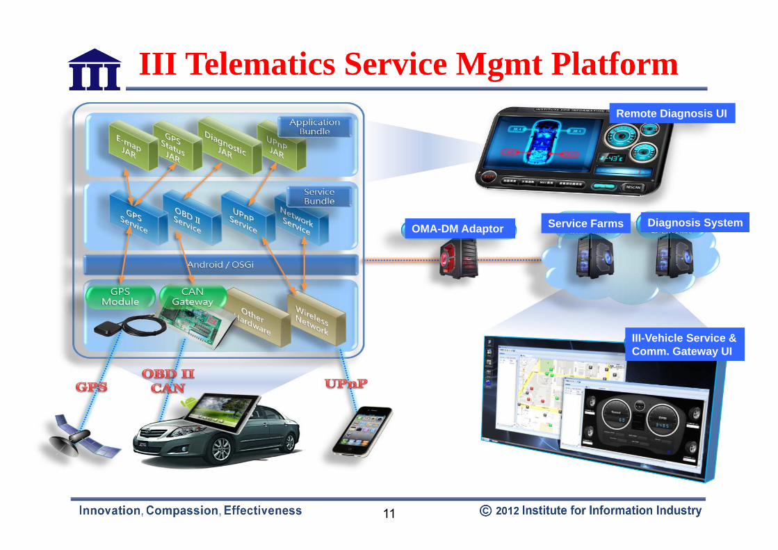
11
III Telematics Service Mgmt Platform
Service Farms Diagnosis System
Remote Diagnosis UI
OMA-DM Adaptor
III-Vehicle Service & Comm. Gateway UI

12
III Media Follow-me (I-MF, V2D)
Private Service Cloud
OBU sync meta data information of the media with the driver's handheld devices while playing.
A driver downloads multimedia (music/video) from Car Vendor's Private Service Cloud to play by the OBU.
Arriving at the destination, the driver still revels in the music. S/he can choose to transfer the yet-to-finish media playing to the handheld and take it with him/her!

13
III-DSRC-Enabled Bus Under Tracking (I-DEBUT; V2R)

14
Out of range taxis intentionally not be contacted
Local broadcasting – radius 500m ~ 1000m
Coverage Extensible by multi-hop (relay) comm., if necessary .
Passenger Taxi(s)passenger-id#, GNSS position, preference
taxi-id.#, features, ETA (estimated time of arrival)
Device-based Taxi Dispatching System (D2V; R2V)
Passenger as “call-center”
by Kiosk or Phone

15
III-Emergency Vehicle Approaching and Detouring (I-EVADE, V2V/V2R)
Through V2V or V2R Communications, emergency vehicles' path is communicated with other vehicles well in advance with IEEE 1609.2-based security mechanism.
Emergency path way is cleared for the priority emergency vehicles via V2V. Traffic lights signals can also be prioritized by V2R
System Operation --• The path of EV can be broadcast to
other vehicles.– Path comparison– Routing/Re-routing
• Traffic light could be controlled by RSU– 1609.2 supporting (encryption,
decryption, signing or verification)– Using SAE-J2735 EVA message

III Precision Position Technology (I-PPT) with Dead Reckoning Navigation (sensor fusion) (V2D)
Source: uBlox
Tunnel drive through

17
Red Signal
Green Signal
Sidewalk
Amber Signal
Traffic controller
Emergently Stop !!!
Dilemma Zone
Can I safely pass?
1.SPaT info. is missing2.Different drivers/vehicle types, …
should act differently.Traffic Signal
In cooperation with Michigan Dept. of Transportation on ITS-- Dilemma Zone Problem

18 18
Dual-Radio SPaT info. Dissemination-- I-DRIVES (III-Dual-Radio Intelligent Voyager Embedded Solution)
III-Roadside Unit(RSU)
III-Onboard Unit(OBU)
WAVE Network
V to R
IEEE 1609 NCTIP over Ethernet
SPaT msg exchangeOver SAE-J2735With intelligent
AlgorithmOn OBU in each vehicle
Pad/PND/NBGIS-enabled GUI
Dilemma ZoneAlgorithm

16
Dilemma Zone Estimation Algorithm
• Current Speed, Current Distance to Stopline• Predictive Speed, Predictive Distance to Stopline
– α-β-γ Kalman Filter
90
92
94
96
98
100
400 500 600 700 800A
ccur
acy
(%)
Activation Distance(m)
3s4s5sSys.
22max
03max max max
0 0 2max max max
( )21( )
6 2
stop
aVa a JX V VJ J a
moving distance from the initial deceleration capacity to the maximum deceleration capability
moving distance from the maximum deceleration ability to stop

20
• SPaT signals will be generated by a signal controller
• SPaT signals are then sent via Ethernet to a dual-radio RSE (with DSRC/Cellular)
• The DSRC RSE wirelessly broadcast the SPaT signals through both DSRC and cellular radios.
• An approaching vehicle receives the broadcast messages, either one or both, depending on the distance between the vehicle and the RSE.
System Operation

21
DSRC Antenna
OBE(DSRC and Cellular)
Cellular Antenna
Signal Controller(Siemens M52)
Cabinet
DSRC Antenna
RSE(DSRC and Cellular)
Cellular Antenna
LBS Server(Cellular)
Cellular Antenna
Moving Direction
SPaT signal
SPaT signal
SPaT Req [Position, Direction] @ 1 Hz
Filtered SPaT signal
SPaT signal @ 3 Hz
(IP over WCDMA)
(IP over WCDMA)
“LBS Server” sends only relevant SPaT information to its
subscribers based on their GNSS
locations.
Dual-mode Communication Flow
NTCIP
SAE-J2735
SAE-J2735

22
Field Trials in Michigan Oakland County

23
Concluding Remarks• Positioning technologies and applications as an important part
of a Smart City– Taiwanese companies have been strong on user segment side fast-growing
on products/systems –
• handheld devices and applications
• aviation and maritime equipment/systems
• car GPS (positioning) applications
• leisure and other uses (payment, emergency rescue, …)
• Integration of smart handheld and OBU as a Car industry trend– Services, such as navigation, emergency rescue, traffic information, offered via
OBU, can now also be obtained through the handheld device
– How to allow OBU to interface with various handheld device to sync information and access applications is main concerns of both Telematics and Vehicle industries

24
Concluding Remarks (Con’d)• Services and contents provisioning as key growing segment
– The U.S. E911 Act requires operators must provide positioning services with the mobile phone industry, mostly with GPS now. Accessing position-related applications from “Cloud” is main concerns of both Telematics and Vehicle industries
– To increase service offer flexibility, major automakers now actively engaged in developing handheld Mobile Apps for services such as navigation, vehicle condition tracking (e.g. oil, tire pressure), remote control (e.g.. door locks, air conditioning, horn)
• Taiwan strong ICT industry on user segment side can partner with EU on GNSS-related technologies and applications– Components : chipset + receiver -- semi-conductor, multi-constellation (GSP
+ Galileo + BeiDou + …), sensor fusion (Galileo + IMU + Gyro + …)– Devices: smart handheld, OBU, … – Applications/Systems: Telematics, LBS, ITS, Surveillance, Emergency
Rescue, Disaster Recovery…..

25
Thank You / Merci / Danke / 謝謝/ありがとう
Your Comments Are Much AppreciatedYour Comments Are Much Appreciated