gmt: the generic mapping tools
TRANSCRIPT

'
&
$
%
GMT: The Generic Mapping Tools
• GMT = a software package to create high-quality postscript maps
and graphs in various projections.
• Output includes standard x-y-plots as well as complicated maps
combined with other geographical referenced data .
• “Around 6000 scientists and engineers worldwide are using GMT in
their work”
• GMT is a highly effective way for creating customized, professional
looking maps or graphs.
• More information and on-line manual: http://gmt.soest.hawaii.edu/

'
&
$
%
Example output

'
&
$
%
GMT: The Generic Mapping Tools
• GMT comes as a set of more than 50 programs and tools, each of
them performing a specific task.
• Most of the time, only 5-6 of these programs are used to plot maps or
simple graphs.
• GMT programs are either called from the command-line or from
shell-scripts .
• GMT commands can be called from you code (C, Fortran, etc.) or
from shell-scripts

'
&
$
%
Your first GMT map
At the command prompt, type:
pscoast -R0/360/-70/70 -Jm1.2e-2i -Ba60f30/a30f15
-Dc -G240 -W1/0 -P > GMT_mercator.ps
To display the resulting map, type: gv GMTmercator.ps
Figure 1: My first GMT map!

'
&
$
%
What did we just type?
• A GMT command to plot coastlines: pscoast
• Followed by a series of arguments in the form -... :
– -R0/360/-70/70 = select frame between longitudes 0/360 and
latitudes -70/70
– -Jm1.2e-2i = use Mercator projection (m) and a scale of 0.012
degree per inch
– -Ba60f30/a30f15 = annotate longitude borders every 60 degrees,
latitude border every 30 degrees, fill longitude borders every 30 degrees,
latitude border every 15 degree.
– -Dc = use a crude resolution for plotting coastlines
– -G240 = color landmasses in light grey (0=black, 255=white)
– -W1/0 = draw coastlines with a 1 point-wide line (i.e. extra thin) in black
– -P = plot in portrait mode (GMT default is landscape)

'
&
$
%
Displaying postscript
• There are several standard tools to display postscript, usually available
on most unix systems:
– ghostview : gs
– ghostscript : gv
– ImageMagick : display
• Note that GMT commands can be directly “piped” into gv for instance:
pscoast -R0/360/-70/70 -Jm1.2e-2i -Ba60f30/a30f15
-Dc -G240 -W1/0 -P | gv -
| (vertical bar) means that the output of GMT is directly fed into (=
“piped” into) gv.

'
&
$
%
Unix
• UNIX is an operating system, i.e. it manages the way the computer
work by driving the processor, the on-board memory, the disk drives,
keyboards, video monitors, etc. and by performing useful tasks for the
users
• UNIX was created in the late 1960s as a multiuser, multitasking
system for use by programmers.
• The philosophy behind the design of UNIX was to provide simple, yet
powerful utilities that could be pieced together in a flexible manner to
perform a wide variety of tasks.

'
&
$
%
Unix: basic commands
• login, logout, work environment
• Current directory? pwd
• Creating a new directory: mkdir directory
• Changing directory:
– Go to home directory: cd or cd ∼user name
– Go to directory /home/users/ecalais/work: cd
/home/users/ecalais/work
– Go to directory one level below: cd ..
• List the content of a directory: ls
– List all files (includind those starting with a .): ls -a
– Show details (ownership, date, etc): ls -l

'
&
$
%
Unix: basic commands
• Create empty file: touch file1
• Copying a file: cp file1 file2
• Moving (= renamimg) a file: mv file2 file3
• Removing a file: rm file3
• Viewing files:
– cat file name
– more file name
• Editing files:
– vi file name, emacs file name
– edit file name (opens a new window)
• Manual pages: man unix command

'
&
$
%
Unix: basic commands
• Connect to remote computer: ssh [email protected]
• Transfer files between computers by ftp :
– Establish connection with: ftp computername.domain
– For secure connection use: sftp computername.domain
– “Anonymous” ftp: ftp computername.domain , username =
anonymous , password your email address
– Change directory on the server: cd directory
– Change directory on the host: lcd directory
– Transfer in binary mode: binary
– Download a file: get file
– Upload a file: put file

'
&
$
%
Unix: variables
set day = 1
echo $day
echo $day > junk
echo $day > /dev/null
@ day = $day + 1
echo $day >> junk
cat junk
Note that:
• > redirects the output of a command to a file. If the file did not exist, it
is created. If the file already existed, it is overwritten!
• >> appends the output of a command to a file. If the file did not exist, it
is created. If the file already existed, the output is appended.

'
&
$
%
Unix: if
set day = 2
if ($day == 2) then
echo you win
else
echo you loose
endif
Try with day = 1 ...

'
&
$
%
Unix: while / foreach
set day = 1
while ($day < 10)
echo This is file $day > file.$day
@ day ++
end
foreach f (*)
echo This is file: $f
end

'
&
$
%
Unix: awk
echo 3 2 | awk {print $1,$2}
echo 3 2 | awk {print $1/$2}
echo 3 2 | awk {print int($1/$2}}
echo 4 | awk {print sqrt($1)}
echo 1234567 | awk {print substr($1,1,4))}
echo 1234567 | awk {print substr($1,5,3))}
set a = ‘echo 1234567 | awk {print substr($1,1,4))}‘
set b = ‘echo 1234567 | awk {print substr($1,5,3))}‘
set c = $a$b
echo $c

'
&
$
%
Unix: grep
echo TOTO > junk
echo TATA >> junk
echo TITI >> junk
cat junk
grep TATA junk
grep TATA junk | awk ’{print substr($1,1,2)}’
set TA = ‘grep TATA junk | awk ’{print substr($1,1,2)}’‘
echo $TA

'
&
$
%
Unix: background/foreground processes, kill
gv
ˆC (control-C)
gv
ˆZ (control-Z)
bg
jobs -l
kill job_number
gv &
jobs -l
kill job_number

'
&
$
%
Unix: background/foreground processes, kill
gv &
ps -elf
ps -elf | more
ps -elf | grep ecalais
ps -elf | grep gv
kill job_number
'
&
$
%
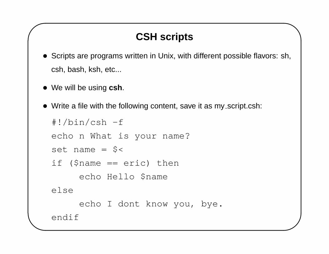
CSH scripts
• Scripts are programs written in Unix, with different possible flavors: sh,
csh, bash, ksh, etc...
• We will be using csh .
• Write a file with the following content, save it as my script.csh:
#!/bin/csh -f
echo n What is your name?
set name = $<
if ($name == eric) then
echo Hello $name
else
echo I dont know you, bye.
endif

'
&
$
%
Running CSH scripts
• Run your script: csh my script.csh
• Make your script executable and run it:
ls -al my_script.csh
chmod +x my_script.csh
ls -al my_script.csh
my_script.csh

'
&
$
%
Your first GMT script
• Create a script file gmt1.csh with the following content:
pscoast -R0/360/-70/70 -Jm1.2e-2i -Ba60f30/a30f15
-Dc -G240 -W1/0 -P > GMT_mercator.ps
gv GMT_mercator.ps &
• Run it using: csh gmt1.csh
• Or make it executable first: chmod +x gmt1.csh
• And then run it: gmt1.csh
'
&
$
%
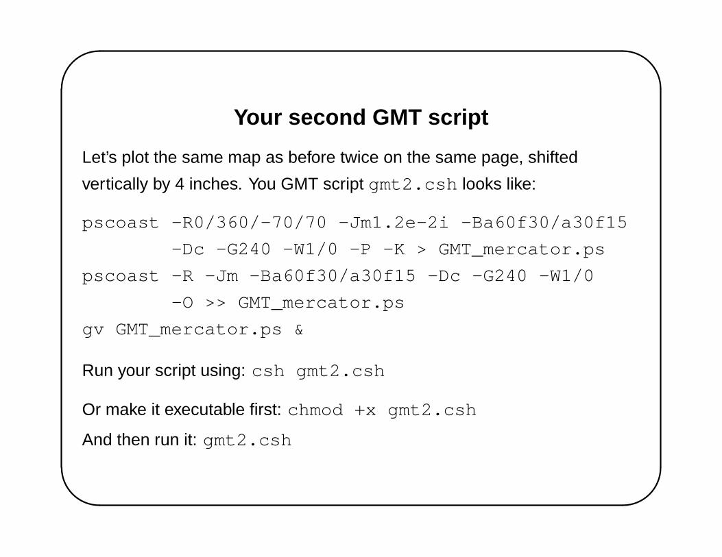
Your second GMT script
Let’s plot the same map as before twice on the same page, shifted
vertically by 4 inches. You GMT script gmt2.csh looks like:
pscoast -R0/360/-70/70 -Jm1.2e-2i -Ba60f30/a30f15
-Dc -G240 -W1/0 -P -K > GMT_mercator.ps
pscoast -R -Jm -Ba60f30/a30f15 -Dc -G240 -W1/0
-O >> GMT_mercator.ps
gv GMT_mercator.ps &
Run your script using: csh gmt2.csh
Or make it executable first: chmod +x gmt2.csh
And then run it: gmt2.csh
'
&
$
%
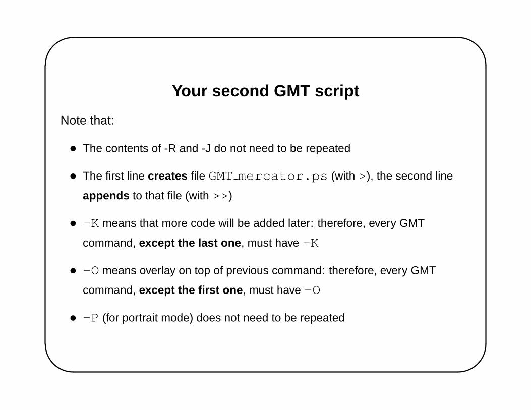
Your second GMT script
Note that:
• The contents of -R and -J do not need to be repeated
• The first line creates file GMTmercator.ps (with >), the second line
appends to that file (with >>)
• -K means that more code will be added later: therefore, every GMT
command, except the last one , must have -K
• -O means overlay on top of previous command: therefore, every GMT
command, except the first one , must have -O
• -P (for portrait mode) does not need to be repeated

'
&
$
%
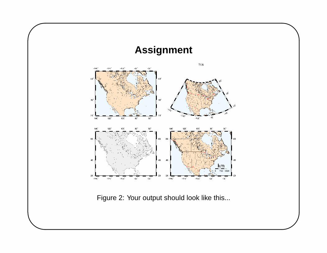
Assignment
Using a csh script, create on the same page 4 maps of North America
(20<lat<65 and -140<lon<-50) using:
• A Mercator projection, grey land masses, white oceans, black
coastline with crude resolution, lat/lon borders annotated every 20
degrees and filled every 5 degrees
• Same as above, but light brown land masses, light blue oceans,
intermediate resolution coastlines, a 1500 km long map scale located
in the bottom right corner of the map
• Same as above, with all major rivers in blue pen, state boundaries in
dashed solid black, country borders in solid red, coastline in dark blue.
• Same as above, using a Lambert projection, without the map scale,
with a title, and the lat/lon annotations along the S and E sides only.
'
&
$
%
Assignment
Figure 2: Your output should look like this...