gm symposium - jon-eric white
TRANSCRIPT

Great Marsh Adaptation Planning
Implications for Quality of Life in our CommunitiesSalisbury
Newburyport Newbury

SALISBURY

SALISBURY
Route 1A (Beach Road)
Salisbury Beach at Broadway
Low-lying houses along the bayside of Salisbury Beach
US Route 1 and Associated infrastructure
Identified Areas of Interest for Adaptation Planning
Current Status
Short-Term Recommendations
Long-Term Recommendations
?
?
?

Salisbury Beach at Broadway
VULNERABILITIES:• Erosion – chronic
and storm-related• Storm surge
flooding
Photo Credit: Gregg Moore

Photo Credits: Sandy Tilton
Barrier beach erosion also on Plum Island in Newburyport and Newbury
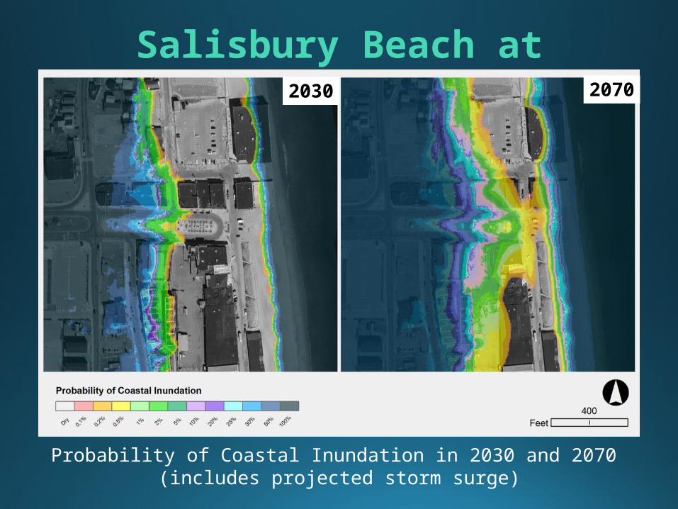
Salisbury Beach at Broadway
Probability of Coastal Inundation in 2030 and 2070 (includes projected storm surge)
2030 2070
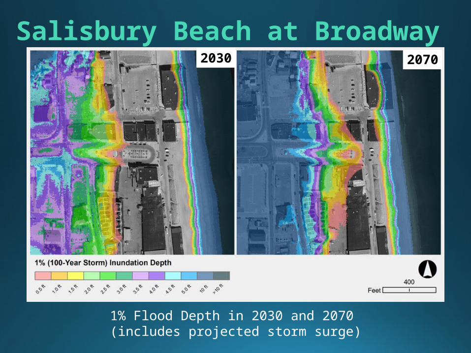
1% Flood Depth in 2030 and 2070 (includes projected storm surge)
2030 2070
Salisbury Beach at Broadway

Photo Credits: Gregg Moore
Research and study of erosion trends
Land acquisition of dune areas, restoring natural systems
Native dune vegetation planting and fencing to enhance health of the dune systems
2016 CZM Resiliency Grant awarded to City of Newburyport for dune nourishment, sand fencing, better trails, and education on northern tip of Plum Island
Salisbury Beach at Broadway Current Adaptation Activities

Continue acquisition of land if/when available and install dunes
Continue dune grass planting & fencing Planning & Zoning: local enforcement of existing
state barrier beach regulations & exploration of other zoning regulations including Beach Overlay Districts
Incentives for developers to build “climate smart”, e.g. raising buildings
Salisbury Beach at Broadway Future Adaptation Strategies

Education of property owners and renters Engagement with business owners and citizens
groups such as the Salisbury Beach Partnership & Merrimack River Beach Alliance
Establish a Salisbury Resiliency Committee
Salisbury Beach at Broadway
Community engagement is critical & zoning is critical!
Future Adaptation Strategies

Need to incorporate climate projections into everyday discussions, decisions and planning,
including economic development

NEWBURYPORT

NEWBURYPORT
Plum Island Turnpike Waste water
treatment facility Lower Artichoke &
Bartlett Spring Pond Business Park Central Waterfront Water Street Plum Island & Beach
Identified Areas of Interest for Adaptation Planning
Current Status
Short-Term Recommendations
Long-Term Recommendations
?
?
?

Newburyport Central Waterfront
Photo Credits: Joe Teixeira
VULNERABILITIES:Flooding during astronomical tides that coincide with multiday storm events, affecting businesses, parks and other recreational areas

Newburyport Central Waterfront
Probability of Coastal Inundation in 2030 and 2070 (includes projected storm surge)

1% Flood Depth in 2030 and 2070 (includes projected storm surge)
Newburyport Central Waterfront

COAST: Coastal Adaptation to Sea Level Rise Tool
One-time Damages from 100-year Flood in Newburyport,
MA Study Area
YearSea Level Rise
Damage to Buildings
2030 Low (0.31 ft)$14.1
Million
2030 Med (0.50 ft)$14.9
Million
2030 High (0.72 ft)$15.8
Million
2070 Low (1.09 ft)$18.3
Million
2070 Med (2.19 ft)$24.2
Million
2070 High (3.45 ft)$32.4
Million
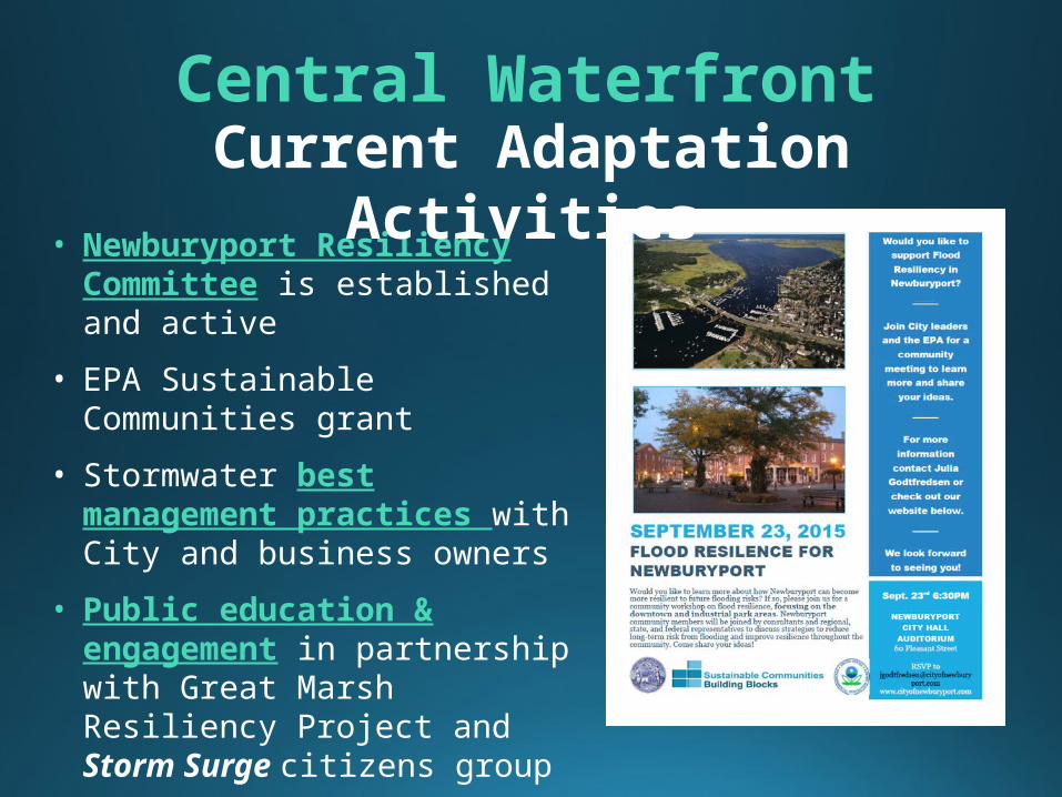
• Newburyport Resiliency Committee is established and active
• EPA Sustainable Communities grant
• Stormwater best management practices with City and business owners
• Public education & engagement in partnership with Great Marsh Resiliency Project and Storm Surge citizens group
Central WaterfrontCurrent Adaptation
Activities

Incorporate climate projections into master planning & future development
Business owner engagement Better overall stormwater management & best
practices Explore building retrofits (e.g. drop-in flood
barriers & longer term floodproofing) to reduce impacts of flooding
Explore opportunities for hybrid adaptation strategies in “hardened” areas of riverbank (e.g. Joppa Park)
Future Adaptation Strategies
Central Waterfront

NEWBURY

NEWBURY
Plum Island Turnpike Plumbush Downs Sewage Vacuum-
Pumping Station on Plum Island
Newbury Elementary School
Newburyport Turnpike/Rt 1
Low-lying houses along bayside of Plum Island
Plum Island & Beach
Identified Areas of Interest for Adaptation Planning
Current Status
Short-Term Recommendations
Long-Term Recommendations
?
?
?

VULNERABILITIES: • Flooding from the
river-side (storm surge plus sea level rise) affects homes, roads, & the PI sewage pump station
Low-lying houses along bayside of Plum Island

Probability of Coastal Inundation in 2030 and 2070 (includes projected storm surge)
Low-lying houses along bayside of Plum Island2030 2070

Low-lying houses along bayside of Plum Island
1% Flood Depth in 2030 and 2070 (includes projected storm surge)
2030 2070

Low-lying houses along bayside of Plum IslandCurrent Adaptation Activities
Coastal zoning and incentives for StormSmart redevelopment and new construction of homes in vulnerable areas
Outreach & education to homeowners and communities

Low-lying housesFuture Adaptation
Strategies
Enhanced property owner education, including the benefits of specific building retrofits such as “freeboard” (raising homes on stilts)
Freeboard incentives Restoring flow with improved culverts, raising
roads if possible
Photo Credit: Pamela Merrill

Low-lying housesFuture Adaptation
Strategies Establish conservancy district zoning overlay to prevent future development in flood-prone areas and to create a long-term buffer between development and flooding
Incorporate climate projections into long-term planningResearch “rolling
easements” as way to deal with the need in some low-lying places to retreat (if/when there is no other option)

Cashman Park, Newburyport Today

Our original idea for resiliency

Our revised post-election idea