global programme of action coalition for the gulf of maine (gpac
TRANSCRIPT


This working paper was prepared for the Secretariat of the Commission for Environmental Cooperation (CEC) and theGlobal Programme of Action Coalition for the Gulf of Maine (GPAC). The views contained herein do not necessarilyreflect the views of the CEC, or governments of Canada, Mexico or the United States of America.
Reproduction of this document in whole or in part and in any form for educational or non-profit purposes may be madewithout special permission from the CEC Secretariat, provided acknowledgement of the source is made. The CEC andthe Wells National Estuarine Research Reserve would appreciate receiving a copy of any publication or material thatuses this document as a source.
Published by the Wells National Estuarine Research Reserve
For more information about this report or to obtain additional copies contact:
The Wells National Estuarine Research ReserveResearch Department342 Laudholm Farm RoadWells, ME 04090Tel: (207) 646-1555vFax: (207) 646-2930
E-mail: [email protected]: http://www.wellsreserve.org
For information about this or other publications from the CEC, contact:
Commission for Environmental Cooperation393, rue St-Jacques Ouest, bureau 200Montreal (Quebec) Canada H2Y 1N9Tel: (514) 350-4300vFax: (514) 350-4314
E-mail: [email protected]: http://www.cec.org
Cover Photo Collage
Background photo: mid-tide in an unaltered salt marsh (i.e., no tidal restrictions). Foreground photos clockwise from topright: wading birds foraging in a salt marsh panne; volunteer sampling vegetation on high marsh (orange color of grassindicates a fall rather than a summer sample date); road crossing with undersized culvert alters hydrology, functions andvalues of upstream marsh (photo taken at low tide in early spring); the mummichog (Fundulus heteroclitus) plays animportant role in the marsh food web; Phragmites australis (commonly referred to as Phrag), a brackish marsh plantthat can become invasive in salt marsh areas where elevations and/or hydrology have been altered. Credits: wading birdsby B.A. King, aerial photo by J.List, others by M. Dionne.
Illustrations on pages 5 and 9 by Thomas R. Ouellette, 57 Hany Lane, Vernon, CT 06066 (860) 872-6180
Report Photo Credits: M. Dionne unless otherwise noted.

RREGIONEGIONALAL S STTANDANDARDSARDS TTOO I IDENTIFYDENTIFY ANDAND E EVVALALUUAATETE T TIDIDALAL
WWETLETLANDAND R RESESTTORAORATIONTION ININ THETHE G GULFULF OFOF M MAINEAINE
A GPAC WORKSHOP
June 2-3, 1999
Report Edited ByHilary Neckles, Workshop Co-Chair
US Geological SurveyPatuxent Wildlife Research Center
26 Ganneston DriveAugusta, ME 04330
andMichele Dionne, Workshop Co-Chair
Wells National Estuarine Research Reserve342 Laudholm Farm Road
Wells, ME 04090
PREFACE ................................................................................................................................ ivACKNOWLEDGEMENTS .............................................................................................................. v
INTRODUCTION ........................................................................................................................ 1OVERVIEW OF THE GPAC INITIATIVE ........................................................................................ 1WORKSHOP PROCESS .............................................................................................................. 2Product Design ................................................................................................................... 2
WORK GROUP REPORTS:DATABASE MODEL FOR RESTORATION & REFERENCE SITE INVENTORY ......................................... 3BASELINE HABITAT MAPPING ................................................................................................... 4TIDAL MARSH RESTORATION MONITORING ............................................................................... 6MONITORING PROTOCOL VARIABLES/ECOSYSTEM INDICATORS
HYDROLOGY ...................................................................................................................... 7SOILS AND SEDIMENTS ......................................................................................................10VEGETATION .....................................................................................................................12NEKTON ..........................................................................................................................15BIRDS .............................................................................................................................18
WORKSHOP SUMMARY: TOOLS FOR REGION-WIDE SITE SELECTION AND MONITORING .................. 20NEXT STEPS ......................................................................................................................... 20
APPENDIX A: GPAC WORKSHOP AGENDA
APPENDIX B: PARTICIPANTS AND STEERING COMMITTEE CONTACT INFORMATION
APPENDIX C: EXISTING INVENTORY MODELS AND MONITORING PROTOCOLS
APPENDIX D: REGIONAL INVENTORY COORDINATORS & REGIONAL TIDAL MARSH
INVENTORY DATA SHEET
APPENDIX E: GULF OF MAINE MARSH ESTUARINE FISH SPECIES
iii
TABLE OF CONTENTS
Robert Shetterly
iv
PREFACE
The Global Programme of Action Coalition for the Gulf of Maine (GPAC) was brought together by the com-mission for Environmental Cooperation (CEC), a North American organization which fosters environmental coop-eration on transboundary issues between the United States, Canada, and Mexico. This binational effort is in responseto the United Nations Environment Program’s global action plan to reduce degradation of marine and coastal envi-ronments. It is internationally recognized that about eighty percent of marine pollution is caused by human activitieson land. GPAC has been working for over two years to facilitate the implementation of the United Nations’ globalplan through the various communities, organizations, industries, and governments of the Gulf of Maine.
In 1998 GPAC engaged in a series of broad discussions via two regional workshops to identify the primary land-based threats to the Gulf of Maine marine environment and to develop actions for reducing or eliminating theirimpacts. These discussions highlighted the importance of tidal wetlands to the ecology, economy, and sustainabilityof coastal ecosystems and some critical gaps in their conservation, restoration, and management throughout Gulf ofMaine jurisdictions. The workshop on “Regional Standards for Identifying and Evaluating Tidal Wetland Restora-tion in the Gulf of Maine” was supported by GPAC as an initial effort to address some of these gaps on a regionalscale.
On behalf of GPAC, we would like to extend our sincere thanks to all who participated in the workshop and whocontributed to its success. We particularly thank the Workshop Steering Committee for adding substance to GPAC’svision and the Wells National Estuarine Research Reserve for graciously hosting the workshop.
The results of the workshop presented in this volume provide the basis for developing some binational programsto enhance tidal wetland restoration across the Gulf of Maine. We are pleased to have been able to help in establish-ing an international network that has been greeted with enthusiasm on both sides of the US-Canada border, and wewish you continued success as these programs are implemented throughout the region.
GPAC Co-chairs:
Joe ArbourEnvironment Canada
Katie RiesNational Ocean Service, National Oceanographic and Atmospheric Administration

We thank the Commission for Environmental Cooperation, the Laudholm Trust, and the Wells National EstuarineResearch Reserve for sponsoring the “Regional Standards to Identify and Evaluate Tidal Wetland Restoration in theGulf of Maine” workshop, held on June 2-3, 1999. This workshop and report represents the culmination of researchplanning efforts initiated at a 1996 New England Estuarine Research Society Symposium on the ecology of marsh-estuarine ecosystems in the Gulf of Maine, funded by planning grant BIR-95222314 from the National ScienceFoundatin to the Wells National Estuarine Research Reserve.
We also express our sincere appreciation to the Workshop Steering Committee for the months spent in organizingthe workshop (see Appendix B for a complete listing). Special thanks go to committee members Arnold Banner,Robert Buchsbaum, David Burdick, Ted Diers, Eric Hutchins, and Charles Roman for leading work group breakoutsessions and contributing their respective summaries to this report, and to Kim Hughes for focusing discussions on theconcluding day of the workshop. Patrick Ewanchuck and Erno Bonebakker provided very helpful comments duringfinal document review. In addition, we thank workshop speakers Katie Ries, of NOAA’s National Ocean Service andGPAC, and Jeffrey Benoit, of NOAA’s Office of Ocean and Coastal Resource Management, for their inspiringremarks.
We are extremely grateful to the Wells National Estuarine Research Reserve (WNERR) for hosting the work-shop. Without the enthusiastic and professional support of Kent Kirkpatrick, Director of the WNERR, and KathrynDavis, President of the Laudholm Trust, this workshop would not have been possible. Most importantly, we thankworkshop coordinator Nancy Bayse for making the workshop and this report a reality. Her expert management andproduction skills, dedication, and unfailing good humor were the key ingredients to workshop success.
Finally, we thank the participants who generously devoted the time to attend the workshop. Their input forms thebasis of this report.
Workshop Co-Chairs:Hilary Neckles, US Geological Survey, Patuxent Wildlife Research CenterMichele Dionne, Wells National Estuarine Research Reserve
CITATION INFORMATION
Neckles, H.A. and M.Dionne, Editors. 2000. Regional standards to identify and evaluate tidal wetland restoration inthe Gulf of Maine. Wells National Estuarine Research Reserve Technical Report, Wells, ME. 21 p. plus appendi-ces. Chapter authors are identified within the report. Individual chapters should be cited as, e.g. Burdick,D.M.2000. Ecosystem indicator:hydrology. p 7-9 in H.A. Neckles and M.Dionne, Editors. Regional standards to identifyand evaluate tidal wetland restoration in the Gulf of Maine. Wells National Estuarine Research Reserve TechnicalReport, Wells, ME.
v
ACKNOWLEDGEMENTS

INTRODUCTION
Restoration of tidal marshes in the Gulf of Maine hasgained considerable momentum during the last ten to fif-teen years. (Dionne et al. 1998) Following several centu-ries of human activities that have altered, degraded, or de-stroyed a large proportion of the tidal marshes in the re-gion, the emphasis of many federal, state, provincial, andnongovernmental programs is now on restoring the naturalhydrology and functional values of these systems. Resto-ration efforts include proactive projects that increase theamount and improve the quality of coastal habitats, andmitigation projects to compensate for permitted impacts
to tidal wetlands. Despite this emphasis, however, theoverall effectiveness of tidal marsh restoration in the Gulfof Maine is uncertain. Contributing to this uncertainty are alack of comprehensive baseline information on sites avail-able for restoration, widely varying degrees of restorationproject monitoring, inconsistencies in monitoring data col-lection, and a paucity of scientifically defensible criteria fordetermining restoration success.
In 1999, the Global Programme of Action Coalition forthe Gulf of Maine (GPAC) initiated a regionally coordi-nated project to address these needs. The goals of theprojects are to develop a Gulf of Maine-wide inventory ofpotential salt marsh restoration sites and a regional moni-toring network of restored and reference salt marshes. OnJune 2-3, 1999, a workshop was hosted by the Wells Na-tional Estuarine Research Reserve in Wells, Maine to de-velop the common protocols needed to establish these re-gional programs. Over the course of a day and a half,resource managers, scientists, and members of communityorganizations from the United States and Canadareached consensus on standard methods for inventoryingrestoration opportunities and for monitoring restorationefforts.
OVERVIEW OF THE GPAC INITIATIVE
The Global Programme of Action for the Protectionof the Marine Environment from Land-based Activities(GPA) was developed under the auspices of the UnitedNations Environment Programme to assist national andregional authorities in reaching the goal of “sustainableseas”. The three North-American countries – Canada,Mexico, and the United States – were among the more than100 signatories who agreed in 1995 to strengthen national,regional and global arrangements for addressing marinedegradation from land-based pollution and activities.
The Commission for Environmental Cooperation(CEC) was established in 1994 by Canada, Mexico, andthe United States under the North American Agreementfor Environmental Cooperation to address transboundaryenvironmental concerns, help prevent potential trade andenvironmental conflicts, and promote the effective enforce-ment of environmental law. The agreement complementsthe environmental provisions of the North American FreeTrade Agreement (NAFTA).
In pursuing its mandate, the CEC is promoting twopilot projects in North America to help implement the GPA.The Gulf of Maine was selected as the focus of one ofthose projects. To carry out this binational effort, the CEChelped establish GPAC, a broad group of individuals fromCanada and the United States with interest in the Gulf ofMaine and the GPA. This group includes representativesof the federal governments of Canada and the United States,governments of the provinces (New Brunswick and NovaScotia) and states (Maine, New Hampshire, and Massa-chusetts) bordering the Gulf of Maine, Native Americantribes, First Nations of Canada, industry, community ac-tion groups, environmental advocacy groups, and researchand academic institutions.
1 Regional Standards to Identify and Evaluate Tidal Wetland Restoration in The Gulf of Maine
This report summarizes the resulting tidal marsh in-ventory model and monitoring protocols for the Gulf ofMaine.
Dionne, M., D. Burdick, R. Cook, R. Buchsbaum, S. Fuller.1998. Scoping Paper 5: Physical alterations to waterflow and salt marshes. Commission for EnvironmentalCooperation. Montreal, Canada. 57p. and appendices.
Undersized culverts significantly reducetidal flow into marsh systems.

GPAC is intended to form the basis for continuedregional cooperation and joint actions in marine and coastalareas of the Gulf of Maine. GPAC set a strategic coursebased on the principles of the GPA and is working towardthe following vision for the future:
“A healthy marine and coastal environmentin the Gulf of Maine where human use andbiological diversity thrive in harmony.”
To help implement the GPA in the Gulf of Maine, GPACdraws from and builds on the existing work of the Gulf ofMaine Council on the Marine Environment, the RegionalAssociation for Research in the Gulf of Maine, the CEC,and other organizations and individuals committed to theprotection of this shared public resource of world-classcultural, economic and ecological value.
In 1998, GPAC sponsored two workshops to identifythreats from land-based activities to marine and coastalhabitats of the Gulf of Maine and determine strategies andmeasures to address these threats. Participants represent-ing a broad range of disciplines, interests, and organiza-tions developed a list of priority pollution and habitat is-sues requiring Gulf-wide action at the first workshop, whichwas held in Saint John, New Brunswick on April 27-28.These priority issues were combined into 5 broad catego-ries, one of which focused on Physical Alterations to Wa-ter Flow and Salt Marshes. At the subsequent workshop inPortland, Maine on November 15-17, participants reviewedexisting activities in the Gulf of Maine region related tothese priority issues, identified gaps in current environmen-tal protection and land-use programs, and proposed a se-ries of actions to protect the coastal and marine environ-ment from pollution and disturbance arising from land-based activities. Through this process, the need for a Gulf-wide inventory of potential tidal marsh restoration oppor-tunities and regionally applicable standards for evaluatingtidal marsh restoration projects emerged as high priorities.The workshop described in the following pages representsthe next step toward addressing these needs on a regionalbasis.
existing information. For example, various tidal marsh in-ventory models are in use within specific jurisdictions ofthe Gulf of Maine region, each including certain site char-acteristics to be evaluated with varying degrees of overlap(Appendix C). Similarly, a number of protocols also existfor monitoring restored tidal marshes in the region, someof which emerged from previous workshops on the samesubject (Appendix C). This information provided a criticalspringboard for work group discussions.
Inventory work group participants used existing data-bases to propose data fields for inclusion in the regionalsite inventory database model. To be selected as a fieldfor the regional database structure, the required informa-tion was determined to be regionally applicable, reason-ably available, and relevant to making decisions on costsand benefits of potential and completed restoration actions.
Existing protocols for monitoring restoration projectswere distilled into a list of potential variables for consider-ation by the monitoring work groups. Work group partici-pants evaluated potential variables in terms of critical in-formation gained, feasibility, cost (in U.S. dollars), the skilllevel required for measurement, and spatial and temporalsampling frequency. In recognition that application of alengthy, complex monitoring protocol on a large scale wouldbe cost prohibitive, participants were asked to reach con-sensus on a minimum number of core variables to includein a standardized, regional protocol. Participants also rec-ommended the “best” protocol by identifying additional vari-ables, techniques, sampling periods, etc. to be included in amonitoring project as resources allow.
PRODUCT DESIGN
The protocols developed at the workshop are intendedto serve as springboards for assessments of Gulf of Mainesalt marshes that are either likely candidates for restora-tion or that are being restored. To be most successful,these assessments will involve the combined efforts ofpracticing environmental professionals and members of vol-unteer, community based organizations. The products ofthis workshop are intended for use by professionals to planinventory and monitoring projects, and for professionalsand volunteers working in partnership to actually under-take projects. Consequently, the level of detail presentedhere assumes professional involvement. As presented,these methods will assure the consistency of data collec-tion efforts required for implementation on a regional scale.We expect that in most cases, more detailed proceduresof field techniques will be compiled to guide on-the-grounddata collection.
WORKSHOP PROCESS
Workshop deliberations occurred within groups devotedto one of four topics: site inventory, monitoring marsh physi-cal characteristics, monitoring plants and habitat mapping,and monitoring animals.
Workgroup discussions were guided strongly by
Introduction 2

3 Work Group Report: Database Model For Restoration & Reference Site Inventory
WORK GROUP PARTICIPANTS
Summary by: Eric Hutchins-NMFS, Arnold Ban-ner-USFWS, John Catena-NMFS, Lou Chiarella-NMFS,Pascal Giasson-NB DNRE, Jennifer Graham-Ecology Ac-tion Center, Kim Hughes-NB Dept. of the Env., ChuckKatuska-MA Wetlands & Banking Program, Tim Purinton-Northeast Wetlands Restoration,Vic Pyle- RestoreAmerica’s Estuaries, Aviva Rahmani-Ghost Nets, Bob Ru-therford- NS Dept. of Fisheries & Oceans.
RATIONALE
The work group agreed on the following databasestructure to inventory existing and potential tidal marsh res-toration sites. Data fields were selected based on regionalapplicability, availability of information, and relevancefor making decisions on costs and benefits of completed
DATABASE MODEL FOR RESTORATION AND REFERENCE SITE INVENTORY
Aerial View of Webhannet Marsh, within Wells NERRand Rachel Carson NWR, Wells, ME
and potential restoration actions. A Regional InventoryData Sheet and list of regional inventory coordinators areincluded in Appendix D.
CORE VARIABLES
vv Site I.D.: two letter state/province ID followed byconsecutive numerals, max. of five characters, e.g.MA1, MA2, MA3,….MA99
vv Project Name: subjective name, maximum of fortycharacters, e.g. Conomo Point
vv Town/City: town, city, maximum of forty charac-ters, e.g. Manchester-By-The-Sea
vv Waterbody: closest waterbody identified from a1:24,000, 7.5 minute quadrangle map produced bythe US Geological Survey or a 1:50,000 map pro-duced by Energy, Mines, and Resources, Canada,maximum of forty characters, e.g. Saratoga Creek
vv Latitude/Longitude: a point near center of resto-ration site, including degrees, minutes and seconds,e.g. 40° 18’ 23” N, 70° 34’ 45” W
vv Owner: public and/or private, and/or Non-Profit Or-ganization; enter owner acronym or abbreviation ifknown, otherwise use PUB/PRV/NPO, maximum of15 characters, e.g. USFWS/PRV/NPO
vv Historic Condition: pre-impact National WetlandsInventory Classification (US) or Canadian WetlandsAtlas Classification (Can) or specific species, maxi-mum of 30 characters, e.g. E2EM/S.patens
vv Nature of Alteration: select from following list: tidalrestriction, fill, stormwater, bulkhead, ditching, salt hay,other; maximum of 40 characters, e.g. tidal restric-tion/stormwater
vv Impacts: consequence of alteration from followinglist: drained marsh, impounded, flooded, invasive veg-etation, other; maximum of 40 characters, e.g. drainedmarsh/invasive vegetation
vv Area: practicable area of enhancement/restorationin square meters; this is the area improved, not justthe area worked on (e.g. dam removal area would belarge, but the area restored could be small) maximum12 characters, e.g. 8,000 m2
vv Restoration Action: select from following list: fillremoval, stormwater treatment, culvert enlargement,ditch plugging, other, maximum 40 characters, e.g. fillremoval/ stormwater treatment
vv Estimated Cost: three ranges, (<10K), (10K – 100K)or (>100K), maximum 10 characters, e.g. 10K – 100K
vv Actions: check all that apply from the following listand record date of entry: none, pre-monitoring, per-mitted, implementation, post-monitoring, e.g. pre-moni-toring, permitted, implementation, 9/00
vv For More Information: two names and contact info.for additional information, e.g.John Catena, NMFS, 1Blackburn Drive, Gloucester, MA 01903, P: 978-281-9313, Email: [email protected]

Work Group Report: Baseline Habitat Mapping 4
MAPPING METHODS
Methods used to prepare the base map will be directlydependent on the capabilities and facilities available to thesite participants. The most fundamental base map wouldbe intitiated with a 1:24000 scale topographic map, whereasmore sophisticated maps would use an orthophoto baseand geographic information systems (GIS) capabilities. Abase map developed with a GIS platform will have the great-est long-term utility and will be easily modified as datasets become available. It is strongly recommended that GISbe utilized if possible.
There are several approaches to cover type mapping.First, the US Fish and Wildlife Service National WetlandInventory (NWI) database or the Canadian Wetlands Atlasmay have mapped wetland cover types for the monitoringsite. State and provincial resource managment agenciesare also good sources of cover type maps. The NWI mapsare presented on a 1:24,000 base. Oftentimes these mapsare based on older photography (i.e., 1970’s-80’s) and mayneed to be field verified for accuracy. Recent aerial photo-graphs (preferably vertical) are another highly useful sourcefor developing or verifying the cover type base, but on-siteground truthing is always required. State and provincialagencies can also be good sources of aerial photography.
SKILL LEVEL
All components of the base map, except for cover typemapping, can be accomplished by volunteers, with mini-mal initial guidance by professionals. Cover type mappingwill require involvement of professionals with training inphotointerpretation and field ground-truthing; however,with training and oversight, volunteers could accomplishthese tasks. The more sophisticated base maps or series ofbase maps will be developed through GIS platforms forwhich extensive training and computer facilities are re-quired.
WORK GROUP PARTICIPANTS
Summary by: Charles Roman-USGS, and TedDiers-NH Coastal Program, Sarah Allen-NormandeauAssoc., Bruce Carlisle-MA CZM, Carolyn Currin-NOAA,Pam Morgan-UNH, Frank Richardson-NH DES, PeterShelley-Conservation Law Foundation, Lee Swanson-NBDNR.
RATIONALE
The base map provides a foundation for monitoringactivities. The purpose of the core variables defined be-low is to provide the basic minimum information on thelocation and fundamental features of the restoration site(locus map, key physical and cultural features, latitude andlongitude), the general ecological condition of the marsh(cover type mapping), and potential stresses on the marsh(adjacent land use). The base map provides a template forlocation of specific sampling sites and offers a baseline forspatial change analyses (e.g. cover type changes over time).
BASELINE HABITAT MAPPING
Great Blue Heron, Ardea herodias andSnowy Egret, Egretta thulaPhotograph by B.A. King
CORE VARIABLES
vv Locus Map: state, province, city or town of saltmarsh monitoring site
vv Key locator and cultural features associatedwith monitoring site: e.g. rivers, roads, culverts
vv Delineated wetland area/cover types: salt marsh,fresh/brackish marsh, forested wetland, shrub domi-nated wetland, open water (creeks, pannes, pools,ditches), invasive species or species of interest, e.g.Phragmites. If available, National Wetland Inventory(US) or Canadian Wetlands Atlas (Can.) delineationswould be appropriate
vv Manipulations: pre- and post-restoration, e.g. cul-verts, dredging, removal of fill, excavations, additionof fill, etc.
vv Sampling locations: pre- and post-restorationmonitoring (transects, plots, etc.)
vv Base map documentation: sources of base map(USGS or Canadian topographic maps, aerial photo-graphs including scale, type, and date, tax maps, Na-tional Wetland Inventory database, other), scale ofmap and north arrow, latitude and longitude
5 Regional Standards to Identify and Evaluate tidal Wetland Restoration in the Gulf of Maine
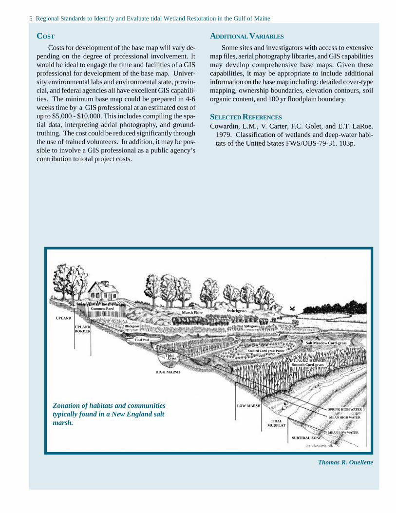
COST
Costs for development of the base map will vary de-pending on the degree of professional involvement. Itwould be ideal to engage the time and facilities of a GISprofessional for development of the base map. Univer-sity environmental labs and environmental state, provin-cial, and federal agencies all have excellent GIS capabili-ties. The minimum base map could be prepared in 4-6weeks time by a GIS professional at an estimated cost ofup to $5,000 - $10,000. This includes compiling the spa-tial data, interpreting aerial photography, and ground-truthing. The cost could be reduced significantly throughthe use of trained volunteers. In addition, it may be pos-sible to involve a GIS professional as a public agency’scontribution to total project costs.
ADDITIONAL VARIABLES
Some sites and investigators with access to extensivemap files, aerial photography libraries, and GIS capabilitiesmay develop comprehensive base maps. Given thesecapabilities, it may be appropriate to include additionalinformation on the base map including: detailed cover-typemapping, ownership boundaries, elevation contours, soilorganic content, and 100 yr floodplain boundary.
SELECTED REFERENCES
Cowardin, L.M., V. Carter, F.C. Golet, and E.T. LaRoe.1979. Classification of wetlands and deep-water habi-tats of the United States FWS/OBS-79-31. 103p.
Thomas R. Ouellette
UPLAND
UPLANDBORDER
HIGH MARSH
LOW MARSH
TIDALMUDFLAT
SUBTIDAL ZONE
Common Reed
Blackgrass
Tidal Pool
Tidal Creek
SPRING HIGH WATER
MEAN HIGH WATER
MEAN LOW WATER
Marsh Elder Switchgrass
Spikegrass
Salt Meadow Cord-grass
Smooth Cord-grass
Stunted Cord-grass Panne
Zonation of habitats and communitiestypically found in a New England saltmarsh.

Tidal Marsh Restoration Monitoring 6
Valid statistical comparisons between pre- and post-restoration conditions and between restored and referencemarshes depend in large part on the independence of rep-licate samples and consequent experimental error terms.More generally, statistical models assume zero correlationamong experimental replicates. Truly random samplingprovides necessary and sufficient insurance against vio-lating this assumption. All of the sampling methods de-scribed here that depend on statistical tests to make infer-ences about the marsh ecosystem assume some type ofrandom sample allocation. The number of samples neededdepends on the size and complexity of the marsh beingdescribed, the variability of the parameter being measured,and the desired precision of the estimate. If preliminarysampling is possible, then the number of observationsneeded to achieve a certain statistical power can be basedon the estimated population variance. Practically, giventhat the precision of estimates increases with sample num-ber, more samples are usually better. In general, the samplesizes included in the protocol were intended for typicalGulf of Maine marshes up to about 20 ha in size. Largesystems with complex hydrologies and broad elevationalranges may require greater sampling efforts.
landscape position, adjacent land use, and water quality.Many restoration efforts in the Gulf of Maine focus onremoving obstructions to tidal flooding caused by roads,dikes, or undersized culverts. In some instances, an ap-propriate reference site may be found downstream fromthe tidal restriction, although it is recognized that down-stream and upstream portions of marshes may exhibit dif-ferent salinity regimes and support different ecological com-munities. A well-studied marsh may also serve as an ap-propriate reference.
The following monitoring protocol for tidal wetlands isbased on a set of core variables within broad categories ofwetland structural and functional responses to restoration.In selecting core variables, work group participants con-sidered the integrative properties of various potential mea-sures and the ease and cost of application on a regionalscale. In some cases, certain variables and samplingschemes emerged as ideally suited for regional implemen-tation; in others, trade-offs between information contentand expediency were required.
The variables and methods identified here representonly one of several ways to characterize marsh response.Collectively, these variables provide a cost-effective andscientifically valid approach for monitoring restorationprojects in a consistent manner throughout the Gulf of Maineregion.
The core variables included in the protocol are the mini-mum deemed necessary to evaluate responses of tidalmarsh ecosystems to restoration. These variables shouldbe monitored at all sites included in the regional network.Restoration projects differ in goals, scope, and availabilityof resources for monitoring, so that additional monitoringof individual projects may be warranted. Additional vari-ables are recommended within each monitoring categoryfor application to specific projects. Each section also listsseveral key references that provide more thorough back-ground and rationale for variable selection and some over-views of sampling methods.
Restoration sites should be paired with “undisturbed”natural reference marshes for monitoring, and ideally,restored and reference systems should be monitored bothbefore and after the restoration is completed. Naturalwetlands are not true controls, but serve as referencesystems for determining whether restoration goals are be-ing met, and they may be essential for distinguishing re-sponses to restoration from natural background variability.
Natural marshes used as reference systems must bein a similar physical setting as the restoration projects towhich they are being compared. Thus salt marsh refer-ence sites should be selected to be similar to restorationprojects in terms of uncontrolled variables such as tem-perature, geomorphology, potential tidal range, elevation,
TIDAL MARSH RESTORATION
MONITORING
Robert Shetterly

ECOSYSTEM INDICATOR:HYDROLOGY
7 Work Group Report-Monitoring Protocol Variable/Ecosystem Indicator: Hydrology
CORE VARIABLES
vv Tidal Signal: The pattern of water level change(maximum of 15 minutes between measurements)with respect to a reference point
vv Surface Elevations: Marsh surface elevation(contour intervals of 15 cm or less)
SAMPLING METHODS
Two types of data are needed to describe thehydroperiod; each must be collected within the entire areaaffected by the planned restoration. These data will beused to assess the potential hydroperiod, to understand therelationship between flooding and habitat type and to pre-dict the habitat that could result under different restorationand management options.
Tidal Signal
Automatic water level recorders should be operatedsimultaneously for a minimum of two weeks, i.e., onelunar cycle of spring and neap tides (one month, or twolunar cycles is better) near the source of tidal influx. Fortidally restricted marshes, recorders should be installed bothupstream and downstream of the tidal restriction. Either awater level gauge or pressure transducer would produce atidal curve yielding the necessary data. Lacking access toan automated water level recorder, 10-minute measure-ments over 13-hour periods using a simple tide staff (avertical ruler fixed in the tidal channel) for three springand three neap tides would provide adequate information.Using either method, the elevations of the upstream anddownstream devices are required, preferably referenced toNGVD (National Geodetic Vertical Datum). At a mini-mum, the relative elevations of the water level recorders inthe impacted and reference marshes must be known.
Robert Shetterly
Tidegates deprivesalt marshes ofessential tidal flow.These gates, onBack River Creek,Woolwich, ME havebeen removed.
WORK GROUP PARTICIPANTS
Summary by: David Burdick-UNH Jackson Estua-rine Lab., Kim Hughes-NB Dept of Environment, HilaryNeckles-USGS, Richard Orson-Orson EnvironmentalAssoc., Edward Reiner- US EPA, Henry Rines-Applied Sci-ence Associates, Inc., Jan Taylor-USF&WS, Larry Ward-UNH Jackson Estuarine Lab.
RATIONALE
The fundamental control on the structure and functionof salt marsh habitat is flooding with salt water.Hydroperiod is the amount of time, in terms of frequencyand duration, that the area is flooded. The hydroperiodwithin a marsh is determined by the tidal signal and eleva-tion.
The most common impacts to salt marshes in the Gulfof Maine are caused by hydroperiod alterations resultingfrom tidal restrictions caused by roads, railroads, or otherobstructions to tidal flow; restoration focuses on increas-ing tidal exchange. Hydroperiod alterations can also resultfrom mosquito ditching, an extensive practice in Gulf ofMaine marshes. Methods are being developed to restorenatural hydrology to ditched marshes.
Although tidal predictions may be available for astro-nomical tides affecting coastal areas close to the restora-tion site, local variation (naturally and resulting from hu-man activities) makes it imperative to obtain actual mea-surements at the specific location to be restored. Similarly,the elevation of the marsh surface relative to the tidal heightmust be measured.
The monitoring methods outlined are appropriate formany types of salt marsh restorations. Because of the preva-lence of tidally restricted marshes in the Gulf of Maine,data collection for this type of restoration is stressed.

Regional Standards to Identify and Evaluate Tidal Wetland Restoration in The Gulf of Maine 8
Surface Elevations
There are two acceptable approaches to obtain thissecond type of data needed to calculate hydroperiod. Bothrequire the skills of professionals. The preferred approachis to produce a contour map of marsh elevations through-out the entire area to be restored, e.g. both upstream anddownstream of a restriction. The contours must be at15 cm intervals or smaller to make meaningful predictionsregarding habitat. The area of marsh flooded by a particu-lar tide or the amount of time it is flooded per month canthen be calculated (hydroperiod). Lacking the resourcesto produce such a map, relative elevations of 40 to 100randomly selected points can be used to produce a hypso-metric curve. These points can be obtained by taking mea-surements at regular 5-10 m intervals, e.g. every 5 metersalong transects running across the marsh from high tideline to high tide line, as delineated by the wrack line aroundthe marsh perimeter. Application of the hypsometric curveto marsh surface area provides an estimate of the amountof marsh area flooded for any particular tidal height and,coupled with the tidal signal, can yield the hydroperiod.
SAMPLING DESIGN
Tidal signal data should be collected for a period of 2-4 weeks prior to the restoration and soon after restoration.The number of elevation data points needed to generate acontour map or hypsometric curve will depend on the areaand the morphology of the marsh. Elevations need to bemeasured only once, but close to the date of restoration.Subsequent measures of tidal signal or surface elevationscan be left to the discretion of the responsible managementagency, but should be performed at least every 5 years.For tidally restricted marshes, information should be ob-tained both above the restriction and in an adjacent area ofmarsh below the restriction.
COST
Costs are estimated for work performed in one sam-pling period (e.g. pre-restoration, post restoration year one,year five, etc.) at a site no larger than 10 hectares (22 acres).For variables that require more sampling at larger sites,costs will be greater. Collection of tidal signal data using2 automated recorders requires about $1500 for equipment,2-4 days of professional work for deployment and datacollection and 1-3 days of professional work for data pro-cessing. Alternatively, use of tide staffs would require about$200 for equipment, and 2-4 days of professional workfor data processing. Generating a contour map requiresabout $1500 for equipment, 3 days of field work and 2-4days of professional work. Alternatively, generating a hyp-sometric curve of marsh elevations requires about $500for equipment, 2 days of field work, and 2-4 days of pro-fessional work. Survey and other equipment can often beborrowed from agencies or academic institutions.
ADDITIONAL VARIABLES
Tidal Creek Cross-SectionsCross-section profiles of major tidal creeks can be mea-
sured prior to restoration and at 2-3 year intervals post-restoration. Profiles are measured using standard surveytechniques, with special care not to damage the escarpments.The position of the profile should be carefully marked sothat the identical cross-section can be monitored follow-ing restoration.
SKILL LEVEL
Tidal signal measurements using pressure transducersor tidal gauges require professionals for installation, datacollection, data reduction and interpretation. Tidal staffsinstalled by professionals may be read and recorded byvolunteers, but data should be reduced and interpreted byprofessionals. Marsh surface elevations and correction toNGVD as well as map or hypsometric curve generationrequire professionals.
DD
Downloading water quality data collectedby data logger
Example of a hypsometric curve.

Water table depth
Under circumstances where an important goal of therestoration project is to increase tidal flooding to reduceinvasive upland or wetland species, water table depth moni-toring is recommended. Changes in water table can bemonitored with wells or piezometers (wells open only nearthe base for the sole purpose of observing groundwaterlevels) placed deep enough in the soil to intersect the watertable during drier periods. Piezometers can be constructedfrom PVC pipe with a screened, perforated interval thatintersects the water table. Stations should be placed ac-cording to recommendations given for soil salinity stations(see Soils and Sediments section) as well as along the up-land edge of the marsh or in populations of plants thatshould be affected by the restoration action. Samplingshould occur at low tide about 6 times a year in the early tomid growing season and include neap and spring tides. Vol-unteers can assist with sampling.
Surface water quality, salinity, and othercharacteristics
If an important goal of the restoration is to improvewater quality, water quality parameters should be includedin project monitoring. Sample stations could be establishedalong the main stem of the channel. Measurements of dis-solved oxygen, salinity, temperature and pH may be ac-complished using an automated data logger. Manual datacollection can be accomplished with portable dissolvedoxygen and pH meters. These should include pre-dawnand noon measurements collected on outgoing spring andneap tides. Carefully trained volunteers can measure sur-face water quality with a high degree of accuracy and pre-cision.
The salinity of the water within tidally-restrictedmarshes should increase following tidal restoration. Sta-tions could be established along the main stem of the chan-nel and salinity measured in the flooding waters on springand neap high tides. The water column is assumed to beunstratified (this should be verified on a flooding tide) andcan be collected by canoe using a bucket or tube. Salinitycan be measured using a temperature-corrected optical re-fractometer to the nearest 2 ppt or a hydrometer and ther-mometer in a graduated cylinder (nearest 1 ppt). Volun-teers can collect water samples and measure salinity.
Extent of tidal flooding
If the hydroperiod (as described above) cannot be mea-sured, it is useful to determine the high water mark. Theperimeter of the flooded area can be walked and mappedat high tide during both spring and neap tides. Other meth-ods can also be used to determine the extent of floodingsuch as measuring the height of water on sticks insertednear the high tide line and coated with cork dust, posterpaint, or craft glue. The flooding water will make a line onthe stick corresponding to the high water mark. Much ofthis work can be performed by volunteers.
9 Regional Standards To Identify and Evaluate Tidal Wetland Restoration in The Gulf of Maine
KEY REFERENCES
Boumans, R.M.J., D.M. Burdick and M. Dionne. In re-view. Modeling habitat change in salt marshes fol-lowing tidal restoration. Restoration Ecology.
Mitsch, W. J., and J. G. Gosselink. 1993. Wetlands.Van Nostrand Reinhold, New York.
Roman, C. T., R. W. Garvine and J. W. Portnoy. 1995.Hydrologic modeling as a predictive basis for eco-logical restoration of salt marshes. EnvironmentalManagement 19:559-566.
U.S.EPA. 1993. Volunteer estuary monitoring: a meth-ods manual. Environmental Protection Agency, Off-ice of Wetlands, Oceans and Watersheds, Washing-ton, D.C. EPA 842-B-93-004.
Current profiles in main channel
Knowledge of the tidal current in the main channel canbe useful when designing the tidal conduit for a tidal resto-ration and to assess the function of the structure as-built.Tidal current should be assessed over several tidal cyclesand can be measured with a recording current meter.
Water table salinitymonitoring well,with refractometerfor measuringsalinity and modi-fied meter stick tomeasure water level

Work Group Report-Monitoring Protocol Variable/Ecosystem Indicator: Soils and Sediments 10
WORK GROUP PARTICIPANTS
Summary by: David Burdick-UNH Jackson Es-tuarine Lab., Kim Hughes-NB Dept of Environment, Hi-lary Neckles-USGS, Richard Orson-Orson EnvironmentalCons., Edward Reiner- US EPA, Henry Rines-Applied Sci-ence Associates, Inc., Jan Taylor-USF&WS, Larry Ward-UNH Jackson Estuarine Lab.
RATIONALE
Soil salinity determines, to a large extent, the distribu-tion and abundance of plant species in salt marshes. Manyrestoration projects are initiated with the goal of reestab-lishing plant communities characteristic of salt marshes,which also involves simultaneously reducing the abundanceof fresh water plants, including invasive species likeLythrum salicaria, or Phragmites australis. Following res-toration, plant distributions are expected to change in re-sponse to increased soil salinity. Measuring salinity sev-eral times during the early to middle growing season wouldprovide the best indicator of changes in environmental con-ditions regulating plant growth, distribution, and abundance.
SAMPLING METHODS
A minimum of five stations should be established forsampling soil salinity. Soil salinity could be sampled anynumber of ways (soil core, sipper, well), but wells may bethe most efficient since there should be about six collec-tion dates a year. Soil water should be collected from 5 to20 cm depths (0 to 5 cm samples are not practical exceptwith soil cores). Wells to determine soil salinity are con-structed from 19mm diameter CPVC plastic pipe with 7pairs of 4 mm holes at sediment depths between 5 and 20cm. The base of the 35 cm pipe is sealed and the top iscapped with two right angles in sequence. Salinity may bemeasured on site or at a laboratory using either a tempera-ture-corrected optical refractometer (nearest 2 ppt) or a hy-drometer and thermometer in a graduate cylinder (nearest1 ppt). Sampling may be performed by volunteers oncestations and methodology are established.
SAMPLING DESIGN
Soil salinities should beobtained throughout the en-tire area to be restored andat an appropriate referencemarsh. Sampling should beperformed at low tide aboutsix times a year between thebeginning of the growingseason (April or May) tomid-season (July or August)including both spring and
neap tides. Sampling could be scheduled each year, but ifannual assessments show positive results from the restora-tion, it could be omitted in some years (for example: pre-restoration, year 1, 2, 4, 5, 7 post-restoration).
A very simple layout of five stations per marsh unit(upstream and downstream of tidal restoration) should beestablished as a minimum for sampling soil salinity in ar-eas restored by increasing tidal exchange. Along the axisof the main channel one station would be placed close tothe restriction, one near the predicted head of tide (afterrestoration) and one equidistant between the two. Thesethree stations would be located in high marsh approximately3 to 4 meters from the tidal channel. Two more stationswould be placed between the central station and the up-land, in high marsh. In a simple circular or rectangularmarsh, the stations would form a cross.
SKILL LEVEL
Once sample locations and methodologies for sam-pling and measurements are demonstrated, volunteers cancollect the samples and measure soil salinity. Volunteerscan also help organize this data for preparation of datareports.
COST
Estimated costs for one sampling interval at a site nolarger than 10 hectares (22 acres) include $200 for equip-ment, 1.5 days of professional work to build wells andestablish stations, 4 days of volunteer or professional workto collect and reduce data, and 2 days of professional workto report data. Costs will be greater at complex sites re-quiring a larger number of stations.
ECOSYSTEM INDICATOR:SOILS AND SEDIMENTS
CORE VARIABLE
vv Pore Water Salinity: parts dissolved salts perthousand (to the nearest 1 ppt); referenced againsta Practical Salinity Scale
Robert Shetterly
Example of alayout of sitelocations for soiland salinitysamples

ADDITIONAL VARIABLES
Organic Matter
Both flooding and salinity control the decompositionrate of organic-rich sediments (i.e., peat) and rapid sedi-ment rebuilding following restoration may be due to in-flux and deposition of inorganic sediments as well as growthof underground storage organs of plants (rhizomes). Thusdetermination of soil organic matter can reveal insights re-garding pre-restoration impacts to the marsh (subsidencedue to oxidation of organic matter in the sediments) andthe process of recovery following restoration. Soil coresto 20 cm depths should be collected from the soil salinitystations and sectioned into 5 cm segments. Soil moisture(% of wet weight) and organic content (% of dry weight)are measured by weight loss after drying, then burning at450° C, respectively. Soil organic matter should be deter-mined once prior to restoration and as needed followingrestoration (e.g. years).
Sediment Accretion
Accretion of inorganic and organic material depositedonto the surface of marshes by flooding waters and veg-etation is one of the important processes that allows marshesto build vertically, offsetting the rise in sea level. Accre-tion is most commonly measured using a marker on thehorizon. A horizon marker is established by applying aknown, identifiable material such as feldspar dust to thesurface of the marsh. The amount of material that has ac-cumulated above the marker can be measured from a sedi-ment core taken at the same site at a later date. The sedi-ment accreted can be reported in mm year -1, or followingdrying and combustion, in g dry weight m-2 year -1 of inor-ganic and organic components.
Sediment Elevation
Net balances in critical soil processes that allow saltmarshes to persist over time may be assessed by measur-ing the surface elevation of the marsh. Loss in elevationindicates peat degradation, whereas gains may be due toaccretion at the surface or peat development below the sur-face. Standard survey techniques are unable to measureshort term changes in elevation (2 to 3 years), but are ad-equate for documenting long term change (10 years orgreater). Short term changes in the sediment elevation ofsalt marshes around the world are being monitored usingSediment Elevation Tables (SET). Installation of the SETsis difficult and requires professionals. Usually only 2 to 4stations are installed in a single marsh. In New England,more than 30 stations exist in several salt marshes fromRhode Island to Maine. Data are being collected
Redox Potential
The degree of chemical reduction/oxidation (redox)in the soil can provide information regarding paths (andrelative rates) of organic matter decomposition in the peatsoils of marshes. Redox potential is measured using com-mercially available or home-made half cell platinum probescalibrated prior to field deployment and equilibrated 30minutes in the sediment. The potential is measured with ahand-held voltmeter connected to a calomel half cell. Rawdata are corrected to obtain Eh values (the standard hydro-gen electrode) by adding +242 mV to the raw readings.Redox potential should be measured at 1 cm and 15 cmdepths at the same stations where soil salinity and organicmatter are measured.
Sulfide Concentrations
Due to the great variability of redox potential, mea-surement of sulfide concentrations provides better infor-mation than Eh regarding oxygen status of the soils. Waterextracted from soils can be fixed in a zinc-acetate solutionand processed at a laboratory to yield sulfide concentra-tions using a spectrophotometer.
KEY REFERENCES
Boumans, R.M.J. and J.W. Day, Jr. 1993. High precisionmeasurements of sediment elevation in shallow coastalareas using a sedimentation-erosion table. Estuaries16:375-380.
Burdick, D.M., M. Dionne, R.M. Boumans and F.T. Short.1997. Ecological responses to tidal restorations of twonorthern New England salt marshes. Wetlands Ecol-ogy and Management 4: 129-144.
Chambers, R.M. 1997. Porewater chemistry associatedwith Phragmites and Spartina in a Connecticut tidalmarsh. Wetlands 17:360-367.
Portnoy, J.W. and A.E. Giblin. 1997. Effects of historictidal restrictions on salt marsh sediment chemistry. Bio-geochemistry 36:275-303.
to provide baseline information, assess projects to restore tidalflow, and assess impacts from dredging. These stations arelocated 10 meters from the high marsh edge of tidal channelsor embayments and human traffic is kept to a minimum.
Soil salinititytested using arefractometer
11 Regional Standards to Identify and Evaluate Tidal Wetland Restoration in The Gulf of Maine

WORK GROUP PARTICIPANTS
Summary by: Ted Diers, NH Coastal Program, andCharles Roman-USGS, Sarah Allen-Normandeau Assoc.,Bruce Carlisle-MA CZM, Carolyn Currin-NOAA, PamMorgan-UNH, Frank Richardson- NH DES., Peter Shelley-Conservation Law Foundation, Lee Swanson-NB DNR.
RATIONALE
The goal of vegetation monitoring is to track trends inplant abundance and species composition of the marsh com-munity over time. A protocol for monitoring restorationprojects must be capable of detecting changes in the veg-etation of the restoring marsh and a reference marsh in theyears following restoration actions, and of determiningwhether and how the vegetation of the restoring marsh dif-fers from that of the reference system over that time pe-riod. In addition, frequently the purpose of a restorationproject focuses on a specific plant species such asPhragmites australis or Spartina alterniflora. In thesecases, more detailed information on individual species ofconcern may be warranted. The methods described belowshould be applied routinely to the marsh plant communityin general, with additional data collected on species of con-cern as appropriate.
1) Identify all plant species (i.e.,species composition).
2) For each species, estimate percent cover by visual ex-amination. Estimate percent bare ground as well.
The estimate should be an integer number that can becategorized within standard Braun-Blanquet coverclasses (<1%, 1-5%, 6-25%, 26-50%, 51-75%, >75%).Estimating cover by visual examination can be some-what subjective; however, it has been demonstrated thatthese measures of cover are comparable to the moretime intensive, quantitative measures of relative abun-dance, such as point intercept counts (Kent and Coker1992).
3) Measure and then average the height of the tallest threeindividuals of each species of concern within each plot.
In addition, for plots restricted to species of concern(see Sampling Design, below), determine the stem densityby species within a subsampled area of the plot.
Photo stationsPhotographs taken from permanent stations can pro-
vide qualitative information on the changes in the plantcommunity over time. Stations should be indicated on mapsand with permanent field markers. The stations should in-clude views of the restoration activity or structures. Twokinds of photo stations should be established – landscapeor panoramic views and close-ups of plots. Landscapephotos are taken at several compass bearings to cover apanorama of the entire marsh. For stands at the site of atidal restriction, bearings showing the downstream marshare desirable as well. Landscape photographs should in-clude a person or an object for height scale. Close-ups areoblique views of a select number of the permanent vegeta-tion plots. The corners of the plots should be identifiedwith orange flagging and the photo taken from a height ofabout 1.2 m (4 ft). Photos should be taken at the time ofvegetation sampling.
SAMPLING METHODS
PlotsThe general marsh community and species of concern
are sampled using 1 m2 quadrats. All sampling should beaccomplished at the time of maximum standing biomass,in mid-summer (mid-July through August).
At each plot, take the following measures:Robert Shetterly
ECOSYSTEM INDICATOR: VEGETATION
Work Group Report-Monitoring Protocol Variable/Ecosystem Indicator: Vegetation 12
Salt marsh hay-Spartina patens
CORE VARIABLES
vv Abundance: cover class per m2 , by species
vv Composition: identity of species per m2
vv Height of species of concern: mean height of 3tallest individuals of each species of concern perm2
v v Stem density of species of concern: # shootsper m2, plots restricted to species of concern, byspecies

SAMPLING DESIGN
Marsh CommunityThe marsh plant community should be sampled using
permanent plots positioned along transects in a systematicsampling design, following Elzinga et al. (1998). Use ofpermanent plots (re-sampled at each sampling interval) al-lows the application of powerful statistical tests for detect-ing change. Systematic sampling allows relatively easypositioning and relocation of quadrats and insures a fairlyuniform distribution of quadrats throughout the study area.
The marsh study area, or areas, should be identifiedand mapped. This may include a marsh that is bisected bya causeway, with one marsh area under the influence ofreduced tidal exchange and another area open to full tidalexchange. Within each marsh study area, transects will beestablished perpendicular to the main marsh tidal creek;transects begin at the creek bank and extend to the upland.So that transects are dispersed fairly uniformly across themarsh, transects are positioned randomly within contigu-ous marsh segments. Divide the marsh into equal-sizedsegments along the axis of the main tidal creek, and ran-domly locate transects within marsh segments. Quadratsare then systematically located along transects. For eachtransect, the location of the first quadrat is selected ran-domly within the low marsh zone, or within the first 3 metersif no zone is apparent. Subsequent quadrats are located atconsistent distance intervals along the transect. Given thatthe transects are established in a random manner, and as-suming that there is adequate spacing between quadrats (>10m) to insure that the plant communities of nearby quadratsare not correlated with each other, each quadrat can serveas a single sample unit (similar to a simple random sam-pling design).
The map or aerial photographs should be used to layout the marsh segments, transects within segments, andquadrats along transects to achieve an appropriate disper-sion of sample plots. In the field, the exact starting loca-tion of transects and quadrats can be determined using arandom numbers table and meter tape.
What should be the total number of 1 m2 quadratssampled within each marsh area? This question should beresolved before the transects and quadrats are established.The ideal way to determine the appropriate number of plotsrequired would be to conduct a power analysis. Using thisapproach, if the variability associated with the measure-ment and the desired level of change detection (i.e., subtlevs. major changes in the marsh community) are known,then the number of replicates required can be determined.A power analysis specific to New England salt marsh veg-etation studies has been completed by the USGS-Biologi-cal Resources Division and is under review. Recognizingthat this analysis is not yet final, and does not necessarilyapply to all Gulf of Maine salt marshes, preliminary find-ings suggest that twenty plots within each study area of upto 50 ha would be adequate to detect subtle changes overtime. Moreover, after several years of data have accumu-lated from specific restoration and reference sites, the in-vestigator will be able to determine the level of variabilityat the site and then adjust to an appropriate number of rep-licates.
Vegetation should be sampled before restoration, 1 and2 years following restoration, and every 3-5 years thereaf-ter. There are several data analysis techniques that can beapplied to detect changes in the vegetation community overtime. Ordination techniques, such as Detrended Correspon-dence Analysis, or an analysis of similarity, are just two ofthe techniques that can be used (see Kent and Coker 1992).
Species of ConcernThere are two ways to monitor species of special con-
cern, such as Phragmites or Lythrum. First, in the routinevegetation community sampling described above, the heightof the 3 tallest plants species of concern should be mea-sured in all quadrats in which it occurs. If species of con-cern are not adequately represented in the marsh commu-nity samples, then a minimum of 5 additional 1 m2 plotsshould be permanently established within distinct stands.Data on all core variables are then collected from theseplots as well during vegetation sampling.
Volunteers usingtransect to monitorvegetation
13 Regional Standards to Identify and Evaluate Tidal Wetland Restoration in the Gulf of Maine

SKILL LEVEL
Vegetation sampling can be done by trained volunteers.A professional should design the monitoring plan and assistwith training.
COST
Sampling equipment is inexpensive, including com-passes, tape measures, PVC piping to construct quadrats,some permanent marker stakes, and some meter sticks.Total equipment cost is less than $500. More expensive isthe camera equipment and film developing cost for thephotostations. The most expensive aspect of the vegeta-tion sampling may be the aerial photography analysis tolocate species of concern and marsh water bodies. If thephotography is not available, then the area may have to beflown. Two to three days of professional involvement areneeded for designing the sampling regime and interpretingdata. Aerial photo interpretation would require additionalprofessional involvement.
ADDITIONAL VARIABLES
Additional measurements to determine vegetative re-sponse to restoration include aboveground biomass, stemdensity, and proportion of stems that are flowering.
KEY REFERENCES
Elizinga, C.L., D. W. Salzer and J.W. Willoughby. 1998.Measuring and monitoring plant populations. BLM Tech-nical Reference 1730-1, BLM/RS/ST-98/005+1730. Bu-reau of Land Management, National Business Center,BC-650B, PO Box 25047, Denver, CO. 477p.
Kent, M. and P. Coker. 1992. Vegetation description andanalysis: A practical approach. J. Wiley and Sons,Chichester. 363 p.
Niering, W. S. and R. S. Warren. 1980. Vegetation pat-terns and processes in New England salt marshes.BioScience 30:301-307.
Regional Standards to Identify and Evaluate Tidal Wetland Restoration in The Gulf of Maine 14
Photo series to the right shows restoration of tide-gated saltmarsh on Mill Brook in Stratham, NH. Sequence from top tobottom: abundance of purple loosestrife prior to restoration;tide-gate replaced by culvert in October, 1993; saltwaterflooding of fresh marsh, spring,1994; colonization by saltmarsh plants, summer, 1994; low marsh and high marsh wellestablished by October, 1999.

WORK GROUP PARTICIPANTS
Summary by: Michele Dionne-WNERR, RobertBuchsbaum-MA Audubon, Sean Ballou-SWAMP, Inc.,Alan Hanson-Waterfowl & Wetlands Ecology, Env. Can,Eric Holt-MA Audubon, Mike Morrison-SWAMP,Inc.,Judy Penderson-MIT Sea Grant College Program, KennethRaposa-URI, Chris Rilling- CT DEP, Greg Shriver-SUNYCollege Env. Sci., Jan Smith-MA Bays Program, GeoffWilson-Northeast Wetlands Restoration, Ray Whittemore-Ducks Unlimited
RATIONALE
Fish are useful indicators of tidal marsh ecosystem func-tions. Their placement in the upper levels of the marshfood web, the wide age and size range of species occuringin marsh habitats, and the wide range of food and habitatresources utilized, are all characteristics that serve to inte-grate salt marsh ecosystem elements, processes and pro-ductivity. Fish and other nekton (e.g. macrocrustaceans)also serve as important ecological links with fisheries innearshore and potentially offshore waters in the Gulf ofMaine.
Mummichog -Fundulus heteroclitus
ECOSYSTEM INDICATOR: NEKTON
15 Work Group Report-Monitoring Protocol Variable/Ecosystem Indicator: Nekton
Throw TrapThe trap is a 1 m2 x 0.5 m high frame made of thin
aluminum bar (2.5 cm width flat stock) with 3 mm meshhardware cloth surrounding the four sides, open at the topand bottom. A 0.5 m wide apron of flexible 3 mm barmesh netting can be attached around the top of the box,with a float line fixed to the upper edge. This allows sam-pling in water up to 1 m deep. To deploy the trap, thesampling station is approached slowly from the marsh sur-face, and the trap is tossed 3-4 m through the air into thewater. The bottom of the trap is immediately pushed intothe substrate to prevent animal escapement. All animalsare removed with a 1 m x 0.5 m dip net (1 mm mesh ) thatfits snugly into the trap, dipping from all four sides of thetrap. After three consecutive net passes devoid of nekton,the trap is considered empty. Animals are placed in a bucketof water for identification and measurement, and then re-leased. Water depth is measured (to the nearest cm) todetermine the volume of water sampled. This samplingmethod works best for smaller fish. Larger fish (> 15 cm)are unlikely to be captured.
Fyke NetThis is a nylon mesh net consisting of a series of four
compartments held open by square frames or fykes, with15 m wings attached to the first and largest (1.2 m X 1.2 mframe) fyke opening. After the first compartment, eachcompartment contains an internal net funnel connected tothe previous fyke frame, with the smaller end of the funnelemptying into the middle of the compartment, 3 inches fromthe bottom. This design channels fish into the net’s codend with little chance of escape. The wings and first threecompartments are made of 1.27 cm bar mesh, with thefinal cod end made of 0.63 cm bar mesh. To measure fishuse of the marsh surface, the net is set at low tide at thelower edge of the marsh with wings at 45o , fykes upright,and cod end and wings anchored. The wing top line isbuoyed and set so that nekton can enter the marsh area bythe side. At high tide, the area of flooded marsh to befished by the net is staked to calculate the area fished.
SAMPLING METHODS
Fish are highly mobile vertebrates that spend all ormuch of their time in the water column. In general theirsenses of sight, hearing, and touch are well developed.These attributes make them a challenging group when itcomes to quantitative sampling, especially in vegetated saltmarsh habitats.
After discussing numerous fish sampling techniques,the throw trap was selected for sampling in the open waterof creeks and channels and the fyke net for use on the veg-etated marsh surface.
CORE VARIABLES
vv Identity: genus and species of each animal sampled(number of fish and crustaceans by species)
vv Density: # of animals per area of sample, by species
vv Length: total animal length/width of individual fishto the nearest 0.5 mm, by species
vv Biomass: wet weight of animals in sample, by spe-cies
vv Species Richness: # of nekton species represented

The catch is placed into buckets of water once the tide hasreceded below the level of the first funnel. To measurefish use of creeks, the net is set at slack high tide across thecreek mouth, to fish the outgoing tide, and the volume ofwater sampled by the net is estimated from creek dimen-sions. This sampling method works equally well for bothsmall and large fish.
For both the throw trap and fyke net, decapod crusta-ceans will be captured as well as fish. When captured,identity, density, size and biomass of crabs and shrimpshould be included in the results.
DATA COLLECTION
Species Identity and RichnessEach individual fish and crustacean collected is iden-
tified to genus and species. A list of species likely to oc-cur in Gulf of Maine salt marsh estuaries is included inAppendix E.
DensityIn order to quantitatively compare fish use of different
marsh sites, fish abundance is adjusted to reflect the vol-ume of water sampled with the throw trap, and the area ofvegetated marsh fished with the fyke net. Fish numbersper sample are divided by the appropriate volume (m3) orarea (m2).
LengthIndividual fish length is measured from the tip of the
snout to the tip of the caudal fin (total length), recorded tothe nearest 0.5 mm. When possible, 30 individuals of eachfish species should be measured, selected haphazardly fromthe sample bucket with an aquarium net. For shrimp, lengthis measured from the tip of the rostrum to the tip of thetelson. For crabs, maximum carapace width is measured.
BiomassThe relationship between length and biomass can vary
considerably depending on species identity and individualcondition. Biomass provides an estimate of standing stock,and can be used to calculate fish condition (length/biom-ass), providing a more complete interpretation of fish sizedata. Total wet weight of all individuals for each speciesis recorded to the nearest gram with an electronic field bal-ance. The number of individuals for each species is alsorecorded.
SAMPLING DESIGN
The occurrence of smaller fishes at mid-tide in marshcreeks is estimated with randomly placed throw trap
Fyke Net
Regional Standards to Identify and Evaluate Tidal Wetland Restoration in The Gulf of Maine 16
samples, 10 samples each in restoration and reference sites,on each of two dates in August during the spring tide cycle.Larger fishes using the creeks are sampled with fyke netsset across small creeks (up to 15 m wide) at slack hightide on the same two dates in August, as well as on twospring tide dates during the spring migrations of diadro-mous fish. Fish using the marsh surface are sampled withfyke nets on one date in August during the spring tide cycle.A pair of nets should be used so restoration and referencemarshes can be sampled at the same time. Until resultsfrom long-term monitoring define the appropriate timeframe, we suggest a minimum of one year pre-restorationdata, and data from years 1,3 and 5 post-restoration.
SKILL LEVEL
Fish are relatively easy to identify and handle, and thedata described above can be collected by volunteers aftertraining. Throw traps can be used by a single person, butfyke nets are bulky and best transported and deployed by ateam of two or three.
COST
Throw traps are inexpensive to construct (<$50) andallow rapid collection of a large number of samples. Esti-mated personnel costs are less than $500 per year. Fykenets can be purchased for about $500 each. Since they arepassive sampling devices, most of the time associated withtheir use is in the set up and take down of the nets. Othersampling (such as throw trap sampling) can be conductedwhile the fyke nets are fishing. Estimated cost for a teamof one technician/student and two volunteers to collect 8channel samples and two marsh surface samples annuallyis $600.
ADDITIONAL VARIABLES1
Fish GrowthFurther understanding of fish growth trajectories over
time can be obtained by calculating fish condition (length/biomass) within size classes for selected species. This re-quires that fish be graded by size class (a surrogate for ageclass) and each size class weighed separately.

17 Regional Standards to Identify and Evaluate Tidal Wetland Restoration in The Gulf of Maine
Fish DietAn assessment of fish gut contents would indicate
whether diets of fish captured in restored marsh sites dif-fered from that of fish in the reference marshes. Differ-ences in diet would indicate differences in the availabilityof food resources. Similarities in diet would suggest simi-larity in food resources between restoration and referencemarshes. However, if many reference and restoration sitesare close together, fish captured in one site may well haveobtained their food from the other site. The source of thefood eaten by the fish would need to be determined beforegut contents could be used to infer similarity between res-toration and reference sites in regards food availability.
Larval Mosquitos
Although the distribution of most tidal marsh inverte-brates is too patchy in time and space to obtain accuratedensity estimates given the sampling effort envisioned forthese protocols, larval mosquitos can be used as indicatorsof some aspects of tidal marsh hydrology. Information onmosquito densities is particularly warranted for restorationprojects that include mosquito control as a primary goal.
Salt marsh mosquito species reproduce in shallowstanding water on the high marsh surface, with the larvaeof different species occurring in fresh, brackish and highersalinity water. The larvae can only persist in pannes thatdo not contain fish, due to the lack of spring tidal flooding,or due to the loss of standing water through drainage andevaporation. Salt marshes that have been invaded by cat-tail (Typha sp.) or Phragmites often harbor freshwatermosquito species, while Aedes cantator is typical of brack-ish water and Aedes sollicitans is typical of higher salini-ties. Larval mosquitos are sampled with a white cup on along handle known as a “dipper” which is used to scoop upwater from the marsh surface. Sampling should occurweekly from April through August along transects that in-tersect standing water on the marsh. The number of dips,the number of positive dips, and the number and species ofmosquito larvae in each dip are recorded. The distributionand abundance of mosquito species relative to the distribu-tion and abundance of standing water can be mapped andused to indicate patterns of tidal flooding on the marshsurface.
1 We include here one variable based on sampling of saltmarsh mosquitos.
ADDITIONAL METHODS
To obtain a more complete picture of fish utilization ofrestored and reference sites, lift nets can be used to samplethe marsh surface. These nets enclose a relatively large
area of marsh (6 m x 6 m), and are folded into a trench onthe marsh surface, beneath rigid vertical supports. At hightide, ropes are used to raise the netting vertically on thesupports to trap fish. As the tide recedes, fish are cap-tured in a cod-end set into a pit dug in the marsh surface.Cost estimate for one lift net is $300. Once constructed,they are relatively easy to use and maintain, so that per-sonnel costs are low (1-2 person-hours per sample).
KEY REFERENCES
Dionne, M., F.T. Short and D.M. Burdick. 1999. Fish uti-lization of restored, created, and reference salt marshhabitat in the Gulf of Maine. American Fisheries SocietySymposium 22:384-404.
Irlandi, E.A. and M.K. Crawford. 1997. Habitat linkages:the effect of intertidal salt marshes and adjacent subtidalhabitats on abundance, movement, and growth of an es-tuarine fish. Oecologia 110:222-230.
Kneib, R.T. 1997. The role of tidal marshes in the ecologyof estuarine nekton. Oceanography and Marine Biology35:163-220.
Minello, T.J. and J.W. Webb, Jr. 1997. Use of natural andcreated Spartina alterniflora salt marshes by fisheryspecies and other aquatic fauna in Galveston Bay, Texas,USA. Marine Ecology Progress Series 151:165-179.
Raposa, K.B. and C.A. Oviatt. 2000. The effects of con-tiguous shoreline type, distance from shore and vegeta-tion biomass on nekton community structure in eelgrassbeds. Estuaries 23:46-55.
Rountree, R.A. and K.W. Able. 1993. Diel variation indecapod crustacean and fish assemblages in New Jer-sey polyhaline marsh creeks. Estuarine, Coastal and ShelfScience 37:181-201.
Rozas, L.P. and T.J. Minello. 1997. Estimating densities ofsmall fishes and decapod crustaceans in shallow estua-rine habitats: a review of sampling design with focus ongear selection. Estuaries 20:199-213.
Szedlmayer, S.T. and K.W.Able. 1996. Patterns of sea-sonal availability and habitat use by fishes and decapodcrustaceans in a southern New Jersey estuary. Estuar-ies 19:697-709.
Varnell, L.M. and K.J. Havens. 1995. A comparison ofdimensional-adjusted catch data methods for assessmentof fish and crab abundance in intertidal salt marshes.Estuaries 18:319-325.

WORK GROUP PARTICIPANTS
Summary by: Robert Buchsbaum-MA Audubon,Sean Ballou-SWAMP, Inc., Michele Dionne-WNERR, Pas-cal Giasson-NB DNRE, Alan Hanson-Waterfowl & Wet-lands Ecology, Env. Can, Eric Holt-MA Audubon, MikeMorrison-SWAMP, Inc., Judith Penderson-MIT Sea GrantCollege ProgramKenneth Raposa-URI-USGS, ChrisRilling- CT DEP, Greg Shriver-SUNY College/Env. Sci.,Jan Smith-MA Bays Program, Geoff Wilson-NortheastWetlands Restoration, Ray Whittemore-Ducks Unlimited
RATIONALE
Birds are highly visible organisms that are popular withthe general public, therefore they are an obvious group toinclude in a monitoring program. In cases where increas-ing the bird use of salt marsh habitat is a major rationale ofa restoration project, monitoring birds is essential for mea-suring success. In addition, there are a number of nonpro-fessional birders who are excellent at identifying birds andare likely to be competent and enthusiastic volunteers.
On the other hand, a difficulty in monitoring birds onrestored marshes relates to the question of scale. Most birds,particularly those charismatic species that are usually ofmost interest (e.g. herons, shorebirds, waterfowl, raptors),have home ranges much larger than the size of typical saltmarsh restoration projects in the Gulf of Maine. Thus it isdifficult to get a large enough number of observations ofindividuals to draw conclusions about habitat use in a re-stored marsh compared with that of a suitable control. Inaddition, wetlands birds in particular have specific habitatpreferences (such as a large percentage of open water orpannes) that may or may not be present in a particular res-toration site.
Abundance by species and number ofspecies (richness) provide information onoverall value of the habitat to birds in asimple, direct way. Behavioral observationsprovide an even better indicator of the valueof the habitat to birds, but the information ismore difficult and time-consuming to collect.More detailed studies of individual species,such as salt marsh sharp-tailed sparrows andother small passerines, may be important de-pending on the particular goals of the resto-ration, but are beyond the scope of routinemonitoring of individual restoration sites.
SAMPLING METHOD
Observations of birds will be made from vantage pointsthat provide an uninterrupted view of at least a portion ofthe salt marsh. The exact location and number of vantagepoints will be site specific. An observer will remain ateach vantage point for 20 minutes, recording the numberof birds of each species within view in the restored andcontrol marsh. Flying birds that are foraging over the marsh,such as swallows, are to be included in the survey, but thosesimply in transit are not. The data sheet will include spaceto record behavioral observations, such as whether the birds
are feeding, involved in nesting, loafing,roosting, etc. Sampling will be carried outonly in the morning. Information will be col-lected on stage of tide, time of day, andweather during each observation period.General information on the site will be col-lected, including dominant plant species andestimated cover of each, number of pannes,area of pannes, and area of unvegetated sur-face.
Work Group Report-Monitoring Protocol Variable/Ecosystem Indicator: Birds 18
ECOSYSTEM INDICATOR: BIRDS
Robert Shetterly
Pannes on the high marsh
CORE VARIABLES
vv Abundance: # of birds per ha, by species
vv Species richness: # of species
vv Feeding and breeding behavior: type offeeding behaviors per 20 minute observation in-terval by species; type of breeding behaviors per20 minute observation interval, by species

COST
Two weeks of direct professional involvement is re-quired to set up the sampling design, train volunteers, andanalyze results. Equipment costs are negligible, since theassumption is that the volunteers would provide their ownoptical equipment.
ADDITIONAL VARIABLES
Small passerines and other cryptic birds of the salt marshSmall passerines, rails, and bitterns will likely be un-
der-represented in observations taken from a high pointabove the marsh. They can be measured by setting up50-m radius counting circles in the salt marsh. An observer
KEY REFERENCES
Bibby, C.J., N.D. Burgess and D.A. Hill. 1992. Birdcensus techniques. Academic Press, New York.
Hanowski, J.M. and G.J. Niemi. 1990. An approach forquantifying habitat characteristics for rare wetland birds.New York State Museum Bulletin 471:51-56.
Hutto, R.L., S.M. Pletshet and R. Hendricks. 1986. Afixed-radius point count method for non-breeding andbreeding season use. Auk 103:593-602
Reinert, S.E. and M.J. Mello. 1995. Avian communitystructure and habitat use in a southern New Englandestuary. Wetlands 15:9-19.
Sibley, D. 1996. Field identification of the sharp-tailed spar-row complex. Birding 23:196-208.
SAMPLING DESIGN
Conduct sampling two times during the breeding sea-son (May and June), once per week during migration ofwaterfowl (late March through the end of April and againin October and November) and shorebirds (late July throughearly September). Such sampling would also incorporatewaders. Sampling should encompass both high and lowtides. Sampling should begin at least one full season be-fore the restoration is initiated.
SKILL LEVEL
Part of the attraction of monitoring birds is that there isa cadre of skilled amateur birders who could participate ina project as volunteers. This would hopefully enable therelatively frequent sampling suggested above. A profes-sional is likely to be needed for data analysis, particularlywhen comparing marshes that differ in area.
19 Regional Standards to Identify and Evaluate Tidal Wetland Restoration in The Gulf of Maine
enters the circle and records all birds seen or heard withina 20 minute time period. If possible, the observer will usea tape recorder to broadcast songs of several species ofmost interest.
Birds in the BufferCounting circles, as described above, can be set up in
the buffer habitat adjacent to the salt marsh. This will en-able evaluation of the importance of the buffer zone tobirds of both the salt marsh and the upland.
Waterfowl in winterThe marsh will be sampled throughout the winter as
long as it is ice free. This will provide information aboutthe use of the restored marsh by wintering waterfowl.
SUBTIDAL ZONE INTERTIDAL ZONE LOW MARSH TIDAL CREEK HIGH MARSH
Spikegrass
Bluefish
Striped Bass
Osprey
RibbedMussel
Suspended Detritus and Phytoplankton
Eelgrass
Export
Winter Flounder
Clam Worm
Smooth Cord-grass
Marsh Fiddler Crab andBurrow
Shore Shrimp
Common Tern
Atlantic Silverside
Crab
Mummichog SaltmarshAmphipod
Saltmarsh Isopod
Saltmarsh Snail
Algae
Snowy Egret
Salt Meadow Cord-grass
Meadow Vole
Blackgrass
Deposited Detritisand Bacteria
Habitats, inhabit-ants, and food weblinkages in atypical NewEngland estuarineecosystem. Thisfigure was origi-nally designed toillustrate a south-ern New Englandsalt marsh. In theGulf of Maine, theblue crab isreplaced by thenon-native greencrab.
Thomas R. Ouellette

Our goal at the workshop was to develop standardizedand realistic methods for 1) identifying Gulf of Maine tidalmarshes suitable as reference or restoration sites, and 2)assessing the response of Gulf of Maine salt marsh ecosys-tems to restoration efforts. The models and protocols pre-sented in this report were the outcome of discussion fueledby the combined experience of nearly fifty tidal marsh sci-entists and resource managers. This group worked dili-gently to achieve consensus regarding the specific param-eters, core variables and methods that would form an ac-ceptable minimum set of data and information with whichto achieve the workshop goals. The details of these proto-cols will undoubtedly be modified as they are put into prac-tice and reviewed, in order to fine-tune their ability to quan-tify regional gains and losses in the functions and values oftidal marshes. Although the workshop focused specificallyon the Gulf of Maine coastline, there is no obvious reasonto restrict the use of the inventory and monitoring proto-cols to this region.
The group charged with developing the template forthe restoration and reference site inventory (Inventoryworkgroup) began with several local inventories and a longlist of candidate parameters. They worked their way throughthe list to select 14 identifiers and descriptors to create theminimum necessary information base. The template con-tains six parameters that identify the name, location andownership of the site; three that describe disturbances andimpacts to the system; four parameters that outline the size,type, cost and nature of potential or actual marsh restora-tion; and a final entry to identify points of contact.
The remaining work groups (Hydrology and Soils, Veg-etation and Mapping, and Animals) focused on identifyingthose ecosystem indicators sufficient for monitoring the suc-cess of tidal marsh restoration projects. At the outset, weagreed the general goal of restoration is to produce a self-sustaining ecosystem that closely resembles the natural sys-tem in structure, function and value. The Hydrology andSoils group identified the elements of hydroperiod, con-sisting of tidal signal and marsh cross-sectional elevations,as core hydrologic variables. For soils and sediments theyidentified pore water salinity as the key indicator. The Veg-etation group discussed the creation of baseline habitat mapsand vegetation monitoring. The baseline map they pro-pose includes cover types, adjacent land use, impacts and
Workshop Summary:Tools for Region-wide Site Selection and Monitoring 20
WORKSHOP SUMMARY:TOOLS FOR REGION-WIDE SITE SELECTIONAND MONITORING
sampling locations. Core variables for vegetation moni-toring are the % cover of plants by species, and plant heightand density for species of special concern. The Animalgroup identified core variables for both birds and nekton.For nekton (captured with traps), these variables are spe-cies densities and wet weights, species richness, and indi-vidual fish length. For birds (observed at a distance), thecore variables are abundance by species, species richness,and feeding and breeding behavior.
The template for the restoration and reference site in-ventory can be used to develop a regional database fromexisting maps and inventories. This database will be ex-tremely useful as salt marsh restoration continues to be-come a more common element of Gulf of Maine coastalresource management. The database will also serve toidentify information gaps on a regional scale. The designof the restoration success monitoring program is based onthe comparison of indicator variables among restorationand reference sites both before (when possible) and dur-ing/after restoration. Some marsh functions and valuesmay recover more quickly than others, and the rate ofchange for any given variable may not be uniform. Oncethe proposed monitoring protocols are implemented acrossa representative range of marsh types and locationsthroughout the Gulf of Maine, it will be possible to deter-mine the appropriate frequency and duration of monitor-ing (i.e. number of years sampled, and interval betweensamples). It may also be possible with sufficient data todevelop a range of reference values characterizing naturaltidal wetland systems across the region.
NEXT STEPS
The workshop products presented here provide thefoundation for developing a Gulf of Maine inventory ofsalt marsh restoration opportunities and a monitoring net-work of restored and reference salt marshes. Implemen-tation of regional inventory and monitoring programs isexpected to occur through partnerships between estuarineprofessionals and volunteer members of community basedorganizations. Broad participation by all individuals work-ing in Gulf of Maine tidal marshes is invited.

21 Regional Standards to Identify and Evaluate Tidal Wetland Restoration in The Gulf of Maine
The standard inventory model will be used to populatea regional database of potential tidal marsh restoration sitesthroughout the Gulf of Maine. Federal, state, and provin-cial agencies charged with tidal marsh protection and res-toration have agreed to use the regional inventory modelfor describing and cataloging restoration opportunities withintheir jurisdictions, and community organizations are alsourged to use this format for local projects. Site-specificinventory data from all sources can then be submitted to aregional database, which will be maintained by the U.S.Fish and Wildlife Service Gulf of Maine Program. Re-gional inventory coordinator contact information is includedin Appendix D. The resulting comprehensive inventory ofrestorable sites will provide a basis for prioritizing amongpotential restoration sites and identifying those most appro-priate for restoration projects. This inventory will offerconsistent baseline information for gauging overall restora-tion progress in the region.
Organizations are also urged to use the standard pro-tocols presented here for monitoring tidal marsh restora-tion projects throughout the Gulf of Maine. Additional fund-ing is being sought to apply the protocol to 30 pairs ofrestored and reference marshes throughout the region. Pro-fessionals will guide data collection efforts, compile datafrom the site network, and synthesize resulting informa-tion. On site data collection will involve members of com-munity based organizations and be facilitated by volunteercoordinators with access to state and provincial reposito-ries of scientific equipment. Ultimately, comparisons ofstandard monitoring variables between a large number ofrestored and reference sites can be used to identify reli-able indicators of restored marsh functions and to suggestregionally applicable success criteria for restoration projects.Such information will be valuable for evaluating the effec-tiveness of tidal marsh restoration in the Gulf of Maine todate and for guiding future restoration efforts.
Inquiries regarding these salt marsh monitoring proto-cols can be directed to the contacts denoted with an “*” inAppendix B.
Photo series to the right shows restoration of impounded saltmarsh on Webhannet River in Wells, Maine. Sequence fromtop to bottom: Cows in drained marsh, 1950’s; colonization bySpartina alterniflora (short form) and Salicornia europea in1991, 3 years after partial restoration of tidal flow; close upshowing salt-killed plants and filamentous green algae in1991; S. alterniflora short form covers much of the area in1994; S. alterniflora increases in density and Spartinapatens becoming more abundant by 1999.

APPENDIX A: Workshop Agenda
WORKSHOP ON RESTORATION OF COASTAL WETLAND ECOSYSTEMS IN THE GULF OF MAINE
June 2-3, 1999Wells National Estuarine Research Reserve
Sponsored by the Global Programme of Action Coalition for the Gulf of MaineAGENDA
Wednesday, June 2
8:30 COFFEE
9:00 WELCOME TO WORKSHOPHilary Neckles, USGS Patuxent Wildlife Research Center - Augusta, ME
9:05 WELCOME TO WELLS RESERVEKent Kirkpatrick, Director, Wells National Estuarine Research Reserve
9:15 INTRODUCTION TO GPACKatie Ries, Deputy Director, International Programs Office, National Ocean Service, NOAA
9:30 WORKSHOP PURPOSE: BACKGROUND, GOALS, AND OBJECTIVESMichele Dionne, Research Director, Wells National Estuarine Research Reserve
10:15 BREAK
10:30 WORKGROUP BREAKOUT SESSIONS
1. Inventory Development2. Monitoring protocol development: Plants3. Monitoring protocol development: Animals4. Monitoring protocol development: Physical components
12:00 LUNCH
1:00 WORKGROUP BREAKOUT SESSIONS (CONTINUED)
3:00 BREAK
3:30 WORKGROUP REPORTS AND PLENARY DISCUSSION
5:30 SOCIAL HOUR AND FIELD TOUR
7:00 BANQUET
WELCOME: Kathryn S.B. Davis, President, Laudholm Trust
INTRODUCTION: Kent Kirkpatrick, Director, Wells National Estuarine Research Reserve
GUEST SPEAKER: Jeffrey R. Benoit, Director, Office of Ocean and Coastal Resource Mgmt., NOAA
Thursday, June 3
8:00 COFFEE
8:30 PLENARY SESSION: REVIEW AND FOCUSKim Hughes, NB Department of the Environment, New Brunswick, Canada
9:00 WORKGROUP BREAKOUT SESSIONS (CONTINUED)
11:00 PLENARY SESSION: SYNTHESISMichele Dionne, Research Director, Wells National Estuarine Research Reserve
12:00 WORKSHOP ENDS
1:30 NOAA – MEETING FOR THE REGIONAL HABITAT RESTORATION PROGRAMJohn Catena, National Marine fisheries Service, Gloucester, MA

Sarah Allen Normandeau Assoc.
25 Nashua RoadBedford, NH 03110
Sean BallouSWAMP, Inc2 Winterbrook Ave.York, ME 03909(207)363-9240
Arnold BannerUS Fish &Wildlife Service4R Fundy RoadFalmouth, ME 04105(207)[email protected]
Jeffrey R. BenoitOffice of Ocean & CoastalResource Mgmt., NOAA1305 EW, Hwy, SSMC #4,Rm 10414Silver Spring, MD 20910(301)[email protected]
*Robert BuchsbaumMassachusetts Audubon346 Grapevine RoadWenham, MA 01984(978)[email protected]
*David BurdickJackson Estuarine Laboratory85 Adams Point RoadDurham, NH 03824(603)[email protected]
Bruce CarlisleMA Coastal Zone Mgmt100 Cambridge StreetBoston, MA 02202(617)[email protected]
Lou ChiarellaNational Marine FisheriesService1 Blackburn DriveGloucester, MA 01930-2298(978)[email protected]
Richard CookAudubon Society of NewHampshire3 Silk Farm Road, PO Box528-BConcord, NH 03302-0516(603)[email protected]
Carolyn CurrinNOAA’s Beaufort Laboratory101 Pivers Island RoadBeaufort, NC 28516-9722(252)[email protected]
Kathryn DavisLaudholm TrustPO Box 1007Wells, ME 04090(207)[email protected]
Ted DiersNH Coastal Program2 1/2 Beacon StreetConcord, NH 03301(603)[email protected]
*Michele DionneWells NERR342 Laudholm Farm RoadWells, ME 04090(207)[email protected]
APPENDIX B: Participants and Steering Committee Contact Information
Christy Foote-SmithMass. Wetlands Restoration &Banking Program100 Cambridge Street20th FloorBoston, MA 02202(617)[email protected]
Pascal GiassonMgr. Wetlands & CoastalHabitat, NB DNREPO Box 6000Fredericton, NB E3B 5H1Canada(506)[email protected]
Jennifer GrahamEcology Action Centre1568 Argyle Street, Suite 31Halifax, NS B3J 2B3 Canada(902)[email protected]
Al HansonWaterfowl & Wetlands Ecology,Env. CN/CWSPO Box 6227Sackville, NB E4L 1G6 Canada(506)[email protected]
Eric HoltMass Audubon Society19 Marlboro StreetNewburyport, MA 01950(978)[email protected]
Chuck KatuskaWetlands Restoration &Banking ProgramOne Winter StreetBoston, MA 02108(617)[email protected]
David KennedyOffice Of Response andRestoration, NOS,NOAA1305 EW Hwy., #10409Silver Spring, MD 20910(301)[email protected]
Kent KirkpatrickWells NERR342 Laudholm Farm RoadWells, ME 04090(207)646-1555 [email protected]
Randy MiltonNS Dept. of NR;Wetlands&Coastal Habitats Prog.136 Exhibition St.Kentville,NS B4N 4E5Canada(902)[email protected]
Pam MorganUniversity of New England85 Adams Point RoadDurham, NH 03824(207)[email protected]
*Kim HughesNB Dept of the EnvironmentPO Box 6000Fredericton, NB E3B 5H1Canada(506)[email protected]
Eric HutchinsNational Marine FisheriesService1 Blackburn DriveGloucester, MA 01930(978)[email protected]
Stewart FeferUS Fish &Wildlife ServiceGulf of Maine Program4R Fundy RoadFalmouth, ME 04105(207)[email protected]
John CatenaNational Marine FisheriesServiceOne Blackburn DriveGloucester, MA 01930(978)[email protected]

Mike MorrisonSWAMP, Inc.2Winterbrook Ave.York, ME 03909(207)363-9240
*Hilary NecklesUSGS Biological Res. Div.26 Ganneston DriveAugusta, ME 04330(207)[email protected]
Rich Orson7D Harbour VillagePO Box 921Branford, CT 06405(203)483-9234
Judith PedersonMIT Sea Grant CollegeProgram292 Main Street, E38-330Cambridge, MA 02139(617)[email protected]
Tim PurintonNortheast WetlandsRestorationP.O. Box 702Rowley, MA 01969
Vic PyleSave The Sound, Inc.185 Magee AvenueStamford, CT 06902-5906(203)[email protected]
Aviva RahmaniGhost NetsOatmeal Quarry,PO Box 692Vinalhaven, ME 04863(207)[email protected]
Kenny RaposaUSGS Biological ResourcesDiv. (Univ. of RI)Naragansett Campus, SouthFerry RoadNaragansett, RI 02882(401)[email protected]
Ed ReinerUS, EPA Region IJFK Federal BuildingBoston, MA 02203(617)[email protected]
Frank RichardsonNH Div Environ ServicesP.O. Box 95Concord, NH 03302(603)[email protected]
Katie RiesNOS, NOAA1305 EW HwySSMC4 Rm #13332Silver Spring, MD 20910(301)[email protected]
G. Chris RillingCT DEP79 Elm StreetHartford, CT 06106-5127(860)[email protected]
Henry RinesApplied Science Assoc.Inc.70 Dean Knauss DriveNaragansett, RI 02882(401)[email protected]
Lorrie RobertsNB Dept of NR & Energy
Wetlands and Coastal HabitatProgramPO Box 6000Fredericton, NB E3B 1T9Canada(506)[email protected]
Charles RomanUSGS BiologicalResources Div.University of Rhode IslandNarragansett Bay CampusNaragansett, RI 02882(401)[email protected]
Jan SmithMass Bays Program100 Cambridge St. 20thFloorBoston, MA [email protected]
Lee SwansonNB DNR, Wetland & CoastalHabitat Prog.PO Box 6000Fredericton, NB E3B 5H1Canada(506)[email protected]
Jan TaylorUSF&WS336 Nimble Hill RoadNewington, NH 03801(603)[email protected]
David ThompsonConservation Council of NBBox 568, RR#2Lepreau,NB E0G 2H0Canada(506)659-2363
Ray WhittemoreDucks Unlimited122 Joe English RoadNew Boston, NH [email protected]
Contacts shown in bluerepresented their respectiveorganizations as members ofsteering committee for thisworkshop.
* Denotes contacts to whomyou may forward inquiriesregarding monitoringprotocol.
Larry WardUniversity of New Hampshire85 Adams Point RoadDurham, NH 03824(603)[email protected]
Alison WardDEP, Bureau of Land &Water Quality17 State House StationAugusta, ME 04333
Geoffrey WilsonNortheast Wetland RestorationP.O. Box 702Rowley, MA [email protected]
Lois WinterUS Fish &Wildlife Svc.Gulf of Maine Program4R Fundy RoadFalmouth, ME 04105(207)[email protected]
Bob RutherfordDept Fisheries & OceansP.O. Box 550Halifax, NS B3J 2S7Canada(902)[email protected]
Peter ShelleyConservation Law Foundation120 Tillson AvenueRockland, ME 04841-3416(207)[email protected]
Greg ShriverSUNY College of Enviro.Sci. and Forestry1 Forestry Dr.Syracuse, NY 13210
Alison SiroisUniversity of ME, CoopExtensionPO Box 309Waldoboro, ME 04572
B2

APPENDIX C: Existing Inventory Modelsand Monitoring Protocols
v Bonnebakker, E.R., P. Shelley and K. Spectre. 2000. Return the tideshandbook (review draft). Conservation Law Foundation, Rockland,ME.
v Bryan, R., M.Dionne, R. Cook, J.Jones and A.Goodspeed. 1997. Mainecitizen’s guide to evaluating, restoring and managing tidal marshes.Maine Audubon Society, Falmouth, ME.
v Bryan, R.R. 1999. Scarborough marsh: historical impacts, current con-ditions, and restoration potential. Maine Audubon Society, Falmouth,ME.
v Burdick, D.M.,R. Buchsbaum, C.Cornelisen and T. Diers. 2000. Moni-toring restored and created salt marshes in the Gulf of Maine: frame-work and data collection methods to guide monitoring programs thatuse volunteers. Report based on a workshop sponsored by the Mas-sachusetts Audubon Society and the Gulf of Maine Council on theMarine Environment.
v Buzzards Bay Project National Estuary Program. 1999. Atlas of tid-ally restricted salt marshes: Buzzards Bay, Massachusetts. Buz-zards Bay Project, MA Coastal Zone Management, East Wareham,MA.
v Cornelisen, C.D. 1998. Restoration of coastal habitats and species inthe Gulf of Maine. Gulf of Maine Council on the Marine Environ-ment.
v Kooken, V., B. Carlisle, A. Hicks and J. Smith. 2000. Volunteer sam-pling program and assessment of salt marshes, North Shore of Mas-sachusetts. WHAT Pilot Project, Salem Sound 2000, Salem, MA.
v Diers, T. and S. Wallace. 1998. Monitoring requirements for saltmarsh restoration projects. New Hampshire Coastal Program. Con-cord, NH.
Lee Swanson 506-453-7108New Brunswick Dept. of NaturalResources & EnvironmentWetlands and Coastal HabitatP.O. Box 6000Fredericton, NB E3B [email protected]
Alan Hanson 506-364-5061Waterfowl and Wetland EcologyEnvironment Canada/CWSP.O. Box 6227Sackville, NB E4L 1G6 [email protected]
Randy Milton 902-679-6224Nova Scotia Dept. of Natural ResourcesWetlands and Coastal Habitats Prog.136 Exhibition StreetKentville, NS B4N 4E5 [email protected]
APPENDIX D: Regional Inventory Coordinators
Lois Winter 207-781-8364USFWS-Gulf of Maine Program4R Fundy Rd.Falmouth, ME [email protected]
Kathleen Leyden 207-287-3261Maine Coastal ProgramMaine State Planning Office38 State House StationAugusta, ME [email protected]
Ted Diers 603-271-2155New Hampshire Coastal Program2 ½ Beacon StreetConcord, NH [email protected]
The following individuals will coordinate the regional inventory of potential tidal marsh restoration opportunities in specific Gulfof Maine jurisdictions. Please contact a local coordinator to contribute tidal marsh inventory data or for more information. Inventorycoordinators will compile data within their jurisdictions and submit to the regional database.
v Linnell, S. 1994. A survey of impounded salt marshes in southernMaine. Master’s Project, Antioch New England Graduate School,Keene, NH.
v Little, M.J. 1995. Potential for the restoration of tidal salt marshes byrestoring tidal flow: an overview with reference to the salt marsh atLocke Road, Rye, NH. Master’s Project, Antioch New EnglandGraduate School, Keene, NH.
v Niedowsky, N.L. 1999. Salt marsh restoration and monitoring guide-lines (review draft). New York State Department of State Divisionof Coastal Resources.
v Purinton, T.A. and D.C. Mountain. 1998. Tidal crossing handbook:a volunteer guide to assessing tidal restrictions. Parker River CleanWater Association, Byfield, MA. 69 p.
v Robie, P., M. Hansen, M. Wildes and D. Paiva. 1994. A method tomonitor the integrity of New Hampshire’s tidal salt marshes (draft#2). Report prepared for U.S.D.A. Soil Conservation Service,Durham, N.H.
v Short, F.T., D.M. Burdick, C.A. Short, R.C. Davis and P.A. Morgan.2000. Developing success criteria for restored eelgrass, salt marsh,and mudflat habitats. Ecological Engineering: in press.
v Tiner, R.W. 1999. Wetland monitoring guidelines (operational draft).U.S. Fish and Wildlife Service, Ecological Services, Region-5 North-east, Hadley, MA 01305.
v United States Department of Agriculture Soil Conservation Service.1994. Evaluation of restorable salt marshes in New Hampshire.Durham, N.H.
v Wade, S.D. 1999. The effects of tidal restrictions on marsh elevationand plant communities of five tidal salt marshes in Wells andKennebunk, ME. Master’s Project, Antioch New England Gradu-ate School, Keene, NH.
v Wells, P. G. 1999. Environmental impacts of barriers on rivers enter-ing the Bay of Fundy: report of an ad hoc Environment Canadaworking group. Technical report series No. 334, Canadian WildlifeService. Dartmouth, Nova Scotia, Canada.
Alan Amman 603-868-7581USDA-NRCS2 Madbury RdDurham, NH [email protected]
Christy Foote-Smith 617-292-5991Mass. Wetlands Restorationand Banking Program100 Cambridge St., 20th FloorBoston, MA [email protected]
Eric Hutchins 978-281-9313National Marine Fisheries ServiceOne Blackburn DriveGloucester, MA [email protected]

APPENDIX D: Regional Tidal Marsh Inventory Data SheetC
ut a
long
dot
ted
line
to r
emov
e T
idal
Mar
sh I
nven
tory
Dat
a Sh
eet f
or c
opie
s, c
ompl
etio
n an
d su
bmis
sion
.##
Site ID: __ __ __ __ __ Date: ___/___/___ (leave blank) (fill in)
Regional Tidal Marsh InventoryData Sheet
Please fill out the form as completely as possible. Your responses will help populate a searchable database,located at http://gulfofmaine.fws.gov, of potential and existing tidal marsh restoration projects in the Gulf ofMaine watershed. Lines for additional notes are optional but will help clarify your responses, especially when“other” is chosen. If your project can be broken down into phases, please submit one form per phase. Thankyou for your participation.
PROJECT NAME (subjective; fill in one letter/punctuation per box including blank boxes for space; e.g. Conomo Point-Phase1)
CITY OR TOWN (e.g. Manchester-By-The-Sea)
WATER BODY (closest waterbody identified from a 1:24,000, 7.5 minute quadrangle map produced by the US geologicalSurvey or a 1:50,000 map produced by Energy, Mines, and Resources, Canada; e.g. Saratoga Creek)
COORDINATES (of a point near the center of the restoration site; e.g. 40oΕ 18' 30" N, 70oΕ 34' 45" W)
LATITUDE ___ degrees ______minutes ______ seconds _____
LONGITUDE ____ degrees ______minutes ______ seconds _____
OWNER(S) check all that apply qprivate
and list owner acronym or qnon-profit organization _____________________ abbreviation if known qpublic ________________________________
ESTIMATED COST (circle one) <$10K $10K-100K >$100K
IS THE PROJECT FUNDED? (circle one) YES NO PARTIALLY
Revised 4/10/2000 Regional Tidal Marsh Inventory Page 1 of 2
D2
AREA IMPROVED: m2 (practicable area ofenhancement/restoration not just the area worked on e.g. a damremoval area would be large, but the area restored could besmall)
STATE OR PROVINCE (circle one): MA ME NH NB NS

HISTORIC CONDITION (pre-impact National Wetlands Inventory Classification (US) or Canadian Wetlands Atlas Classifi-cation (Can) or specific species (scientific); e.g. E2EM/S. patens)
note:
NATURE OF ALTERATION (check all that apply)
qtidal restriction qbulkhead qstormwater qditch qfill qsalt hay
qother
note:
IMPACTS (consequence of alteration, check all that apply)
qdrained marsh qimpounded qflooded q invasive vegetation
qother
note:
RESTORATION ACTION (check all that apply)qstormwater treatment qculvert enlargement qditch plugging q fill removal
qother
note:
ACTIONS (check all that have been completed including the current status)
qnone qpre-monitoring q permitted q implementation q post-monitoring
qother
note:
FURTHER INFORMATION (up to 2 contacts)
RETURN TO: (Regional Inventory Coordinator contact information goes here)
Revised 4/10/2000 Regional Tidal Marsh Inventory Page 2 of 2 J. Fujikawa, 4R Fundy Road, Gulf of Maine Program, Falmouth, ME, 04105, (207)781-8364, [email protected]
D3
Name:Organization:Address:City: State/Province:Zip Code:Phone:E-mail:
Name:Organization:Address:City: State/Province:Zip Code:Phone:E-mail:

vv Alosa aestivalis (blueback herring)vv Alosa mediocris (hickory shad)vv Alosa pseudoharengus (alewife)vv Alosa sapidissima (American shad)vv Brevoortia tyrannus (Atlantic menhaden)vv Clupea harengus (Atlantic herring)vv Ammodytes americanus (American sand lance)vv Anguilla rostrata (American eel)vv Apeltes quadracus (fourspine stickleback)vv Gasterosteus aculeatus (threespine stickleback)vv Gasterosteus wheatlandi (blackspotted stickleback)vv Pungitius pungitius (ninespine stickleback)vv Cyclopterus lumpus (lumpfish)vv Liparis atlanticus (seasnail)vv Decapterus macarellus (mackerel scad)vv Fundulus heteroclitus (mummichog)vv Fundulus majalis (striped killifish)vv Gadus morhua (Atlantic cod)vv Microgadus tomcod (Atlantic tomcod)vv Pollachius virens (pollock)vv Urophycis chuss (red hake)vv Urophycis tenuis (white hake)vv Pholis gunnellus (rock gunnel)vv Menidia beryllina (inland silverside)vv Menidia menidia (Atlantic silverside)vv Menidia peninsulae (tidewater silverside)vv Morone americana (white perch)vv Morone saxatilis (striped bass)vv Mugil cephalus (striped mullet)
APPENDIX E: Gulf of Maine Marsh-Estuarine Fish Species
Fish Species Known to Occur in Salt Marsh Estuarine Ecosystems in the Gulf of Maine
KEY REFERENCES
Bigelow, H.B. and W.C. Schroeder. 1953. Fishes of the Gulfof Maine. Fishery Bulletin 74,Vol.53:577p.
Dionne, M., F.T. Short, and D.M. Burdick. 1999. Fish uti-lization of restored, created, and reference salt marshhabitat in the Gulf of Maine. American Fisheries Soci-ety Symposium 22:384-404.
Robins, C.R., G.C. Ray, and J. Douglas. 1986. A field guideto Atlantic coast fishes of North America. HoughtonMifflin Co., Boston. 354p.
Scott, W.B., and M.G. Scott. 1988. Atlantic fishes ofCanada. Can.Bull.Fish.Aquat. Sci.219:731p.
vv Hemitriperus americanus (sea raven)vv Myoxocephalus aeneus (grubby)vv Myoxocephalus oxtodecimspinosus (longhorn
sculpin)vv Myoxocephalus scorpius (shorthorn sculpin)vv Cryptacanthodes maculatus (wrymouth)vv Osmerus mordax (rainbow smelt)vv Peprilus tricanthus (butterfish)vv Petromyzon marinus (sea lamprey)vv Pleuronectes ferrugineus (yellowtail flounder)vv Pseudopleuronectes americanus (winter flounder)vv Scopthalmus aquosus (windowpane flounder)vv Pomatomus saltatrix (bluefish)vv Salmo salar (Atlantic salmon)vv Salmo trutta (brown trout)vv Salvelinus fontinalis (brook trout)vv Scomber scombrus (Atlantic mackerel)vv Sphyraena borealis (northern sennet)vv Syngnathus fuscus (northern pipefish)vv Tautogolabrus adspersus (cunner)

Tidal Marsh Restoration and Enhancementin the Gulf of Maine
Restoration projects in salt marsh ecosystems in the Gulf of Maine. The majority of projects are character-ized by tidal flow restoration in tidally restricted marshes. Numbers within parentheses indicate multipleprojects at a given site. Asterisks indicate the number of projects characterized by panne construction orditching plugging (to create or replace open water habitat on the high marsh), or perimeter ditches (occasion-ally used to control invasive plants). For example, in Ipswich, MA, of the 6 projects, 5 were panne/ditchprojects, and 1 was a tidal restoration.
New Brunswick
Nova ScotiaMaine
MA
New Brunswick and Nova ScotiaNewfoundland Creek (NB)Annapolis Royal (NS)
Potential Restoration Sites:Musquash EstuaryLower CapeDoverNew HortonKennetcook RiverMcCannPetitcodaic RiverMemramcook River
Map courtesy of R.Signell and E. RoworthU.S. Geological Survey
MaineWeskeag River*Sprague River*Back River CreekPine PointGranite Point*
Marshall Point (2)**Drakes IslandOgunquit River*Brave Boat Harbor*Chauncy Creek*Cutts Island*
NH
New HampshireFairhill Marsh*Awcomin MarshLocke RoadHarbor Road (2)Parsons Creek (2)Little River
Landing Road(2)Drakeside RoadMeadow PondCains BrookBrown’s RiverSeabrook Sta.
Sandy PointMillbrookWoodman Point*Winnicut River*Stubbs Pond*Vol’s Island*
MassachussettsSalisbury*Newburyport (3)Newbury (6)****Rowley (4)***Ipswich (6)*****EssexGloucester*RockportManchester*
SalemMarblehead*Saugus (3)*Revere (8)Chelsea (2)Winthrop (2)Boston (5)MiltonQuincy
ScituateMarshfield (3)KingstonBourneSandwichWelfleetProvincetown