global navigation satellite systems (gnss) sponsors - ggim - ap/icg/linz technical seminar vertical...
TRANSCRIPT

FIG/IAG/UN-GGIM-AP/ICG/LINZ Technical Seminar
Vertical References Frame in Practice
Christchurch, New Zealand, 1-2 May 2016
Sponsors:
Global Navigation Satellite Systems (GNSS)
Dr Suelynn Choy
School of Sciences RMIT University, Australia

FIG/IAG/UN-GGIM-AP/ICG/LINZ Technical Seminar
Vertical References Frame in Practice
Christchurch, New Zealand, 1-2 May 2016
Sponsors:
Overview of Presentation
1. Overview of current GNSS/RNSS status
2. Opportunities with multi-GNSS
2

FIG/IAG/UN-GGIM-AP/ICG/LINZ Technical Seminar
Vertical References Frame in Practice
Christchurch, New Zealand, 1-2 May 2016
Sponsors:
Multi-GNSS/RNSS – System Overview
• Global systems – USA Global Positioning System (GPS)
– Russia Global’naya Navigatsionnaya Sputnikovaya Sistema
(GLONASS)
– EU Galileo
– China BeiDou
• Regional and augmentation systems – Japan Quasi-Zenith Satellite System (QZSS)
– India Indian Regional Navigation Satellite System (IRNSS)
– WAAS, EGNOS, MSAS, GAGAN, SDCM
3

FIG/IAG/UN-GGIM-AP/ICG/LINZ Technical Seminar
Vertical References Frame in Practice
Christchurch, New Zealand, 1-2 May 2016
Sponsors:
GNSS in a Nutshell: Operational Status
Healthy SV Orbiting SV As of Source
GPS 31 31 30/04/2016 NAVCEN*1
GLONASS 23 28 30/04/2016 Information Analysis Centre *2
Galileo 10 12 29/03/2016 European GNSS Service Centre*3
BeiDou-2 BeiDou-3
14 6
16 6
29/03/2016 China Satellite Navigation System Office
QZSS - 1 30/04/2016 QZ-vision*4
IRNSS 7 7 30/04/2016 Indian Space Research Organisation*5
91 101
*1: http://navcen.uscg.gov/?Do=constellationStatus *2: http://www.glonass-ianc.rsa.ru/en/index.php *3: http://www.gsc-europa.eu/system-status/Constellation-Information *4: http://qz-vision.jaxa.jp/USE/en/naqu *5: http://www.isro.gov.in/irnss-programme/towards-self-reliance-navigation-irnss
4

FIG/IAG/UN-GGIM-AP/ICG/LINZ Technical Seminar
Vertical References Frame in Practice
Christchurch, New Zealand, 1-2 May 2016
Sponsors:
GPS
5

GPS Constellation Status (30.04.2016)
• 12 Block IIR satellites
• 7 Block IIR-M satellites
• 12 Block IIF satellites – Broadcasting L5 “safety of life” signals
– Better resistance to jamming
– The final GPS IIF satellite was launched on 5 February 2016 and became available to users on March 9.
• Future Block III satellites (FY17) – Signals 3 times more accurate than current GPS
– Provide military users up to 8 times improved anti-jamming
– Increase SV operational life (25% longer than Block IIF)
– New L1C signal – interoperable with other GNSSs
31 Healthy Satellites Baseline Constellation: 24
6

Increasing System Capabilities w Increasing User Benefit
GPS Modernisation Program
Block IIA/IIR Block III Block IIR-M, IIF • Backward compatibility
• 4th civil signal (L1C)
• 4x better User Range Error than IIF
• Increased availability
• Increased integrity
• 15 year design life
IIR-M: IIA/IIR capabilities plus
• 2nd civil signal (L2C)
• M-Code (L1M & L2M)
IIF: IIR-M capability plus
• 3rd civil signal (L5)
• 2 Rb + 1 Cs Clocks
• 12 year design life
Basic GPS
• Standard Service
– Single frequency (L1)
– Coarse acquisition (C/A) code navigation
• Precise Service
– Y-Code (L1Y & L2Y)
– Y-Code navigation
7

Standard Positioning Service (SPS) Signal-in-Space Performance
8

GPS Horizontal Position Accuracy
Source: http://www.gps.gov/systems/gps/performance/accuracy/
3.351 m
9

FIG/IAG/UN-GGIM-AP/ICG/LINZ Technical Seminar
Vertical References Frame in Practice
Christchurch, New Zealand, 1-2 May 2016
Sponsors:
GLONASS
10

Summary
• GLONASS Program is high priority of the Russian Government
The Presidential Decree № 638 dated May 17, 2007: “On Use of GLONASS (Global Navigation Satellite System) for the Benefit of Social and Economic Development of the Russian Federation”
• GLONASS open service is free for all users
• GLONASS achieved FOC 19 December 2011
• GLONASS performance to be comparable with GPS
• GLONASS will continue
– Keep the GLONASS traditional frequency bands
– Transmit existing FDMA signals
– Introduce new CDMA signals
• New GLONASS Program (2012 – 2020)
– Adopted 3 March 2012
– GLONASS sustainment, development, use
• International cooperation – make GLONASS as one of key elements of the international GNSS for worldwide use
11
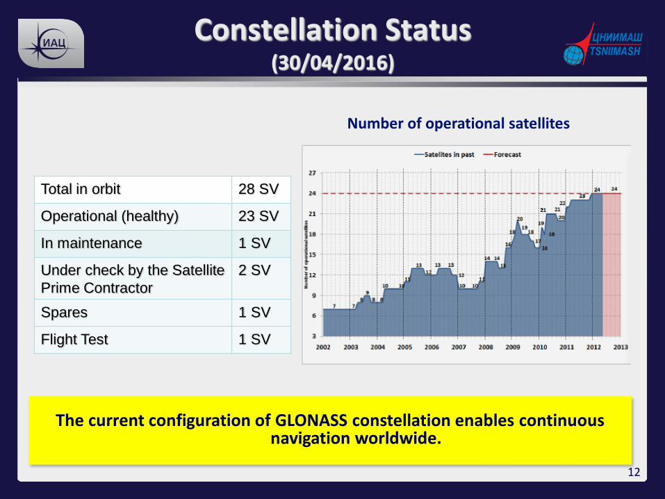
Constellation Status (30/04/2016)
Total in orbit 28 SV
Operational (healthy) 23 SV
In maintenance 1 SV
Under check by the Satellite
Prime Contractor
2 SV
Spares 1 SV
Flight Test 1 SV
Number of operational satellites
The current configuration of GLONASS constellation enables continuous navigation worldwide.
12
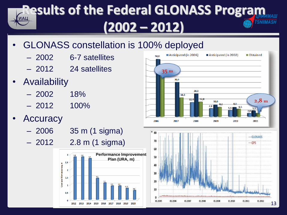
Results of the Federal GLONASS Program (2002 – 2012)
• GLONASS constellation is 100% deployed
– 2002 6-7 satellites
– 2012 24 satellites
• Availability
– 2002 18%
– 2012 100%
• Accuracy
– 2006 35 m (1 sigma)
– 2012 2.8 m (1 sigma)
Performance Improvement
Plan (URA, m)
13

1982 2011 2003 2013-2014
• 3 year design life
• Clock stability - 5*10-13
• Signals: L1SF, L2SF, L1OF, (FDMA)
• Totally launched 81 satellites
• Real operational life time 4.5 years
• 7 year design life
• Clock stability 1*10-13
• Signals: Glonass + L2OF (FDMA)
• Totally launched 28 satellites and going to launch 8 satellite by the end 2012
• 10 year design life
• Unpressurized
• Expected clock stability ~10…5*10-14
• Signals: Glonass-M + L3OC (CDMA) – test
• SAR
• 10 year design life
• Unpressurized
• Expected clock stability ~5…1*10-14
• Signals: Glonass-M + L1OC, L3OC, L1SC, L2SC (CDMA)
• SAR
“Glonass” “Glonass-M” “Glonass-K1” “Glonass-K2”
GLONASS Modernisation Plan
CDMA signals general structure already designed 14

FIG/IAG/UN-GGIM-AP/ICG/LINZ Technical Seminar
Vertical References Frame in Practice
Christchurch, New Zealand, 1-2 May 2016
Sponsors:
Galileo
15

Navigation solutions powered by Europe
Galileo Implementation Plan
16

Navigation solutions powered by Europe
The Galileo Service
17

Navigation solutions powered by Europe
Galileo Space Segment
18

FIG/IAG/UN-GGIM-AP/ICG/LINZ Technical Seminar
Vertical References Frame in Practice
Christchurch, New Zealand, 1-2 May 2016
Sponsors:
BeiDou
21

History and Innovation
• BeiDou-1 (2000s)
– 2 GEO satellites, active positioning system • BeiDou-2 (formerly Compass, 2007-2015)
– Regional service with a total of 15 satellites
• 6 GEO, 6 IGSO, 4 MEO (Feb 2016)
• BeiDou-3 (2015 - 2020)
– Global service with a total of 35 satellites
• 5 GEO, 27 MEO, 3 IGSO
• 1 February 2016: 21st BDS (MEO) satellite
• 5 April 2016: 22nd BDS (IGSO) satellite
• Another 18 satellites by the end of 2018
22

Constellation
23

Operational Performance
24

FIG/IAG/UN-GGIM-AP/ICG/LINZ Technical Seminar
Vertical References Frame in Practice
Christchurch, New Zealand, 1-2 May 2016
Sponsors:
IRNSS
25
FIG/IAG/UN-GGIM-AP/ICG/LINZ Technical Seminar
Vertical References Frame in Practice
Christchurch, New Zealand, 1-2 May 2016
Sponsors:
26

FIG/IAG/UN-GGIM-AP/ICG/LINZ Technical Seminar
Vertical References Frame in Practice
Christchurch, New Zealand, 1-2 May 2016
Sponsors:
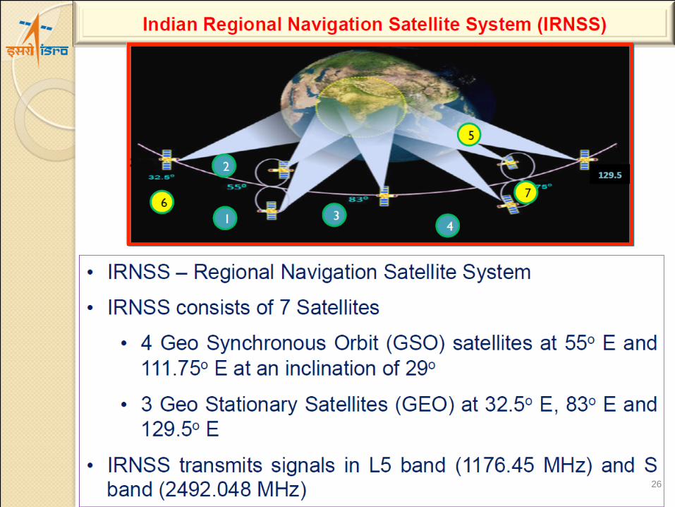
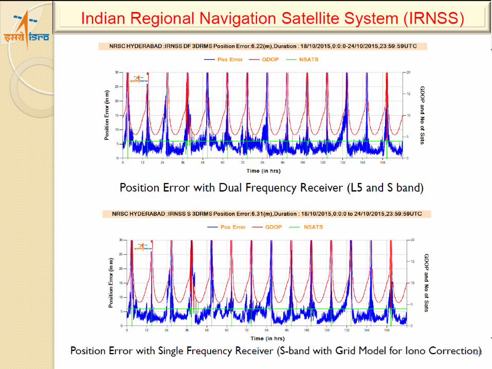
• IRNSS shall provide two types of services – Standard Positioning services (SPS) and Restricted Services (RS)
• 7 IRNSS satellites are successful realized in orbit:
– 5th: IRNSS-1E, GSO (20 January 2016)
– 6th: IRNSS-1F, GEO (10 March 2016)
– 7th: IRNSS-1G, GEO (28 April 2016)
• Current constellation satellites are functional with navigation signals in L5 and S-band.
• Efforts to bring in L1-band in future satellites are under progress.
• Renamed - Navigation with Indian Constellation or NavIC (नाविक = sailor/navigator)
27
FIG/IAG/UN-GGIM-AP/ICG/LINZ Technical Seminar
Vertical References Frame in Practice
Christchurch, New Zealand, 1-2 May 2016
Sponsors:
28

FIG/IAG/UN-GGIM-AP/ICG/LINZ Technical Seminar
Vertical References Frame in Practice
Christchurch, New Zealand, 1-2 May 2016
Sponsors:
QZSS
29
∞∞∞∞∞∞∞∞Quasi-Zenith Satellite System ∞∞∞∞∞∞∞∞Quasi-Zenith Satellite System ∞∞∞∞∞∞∞∞Quasi-Zenith Satellite System ∞∞∞∞∞∞∞∞
-4.0
-3.0
-2.0
-1.0
0.0
1.0
2.0
3.0
4.0
2011/6/3 2011/6/5 2011/6/7 2011/6/9 2011/6/11 2011/6/13 2011/6/15
SIS-
UR
E[m
]
SIS-URE[m]
仕様値
Current Status
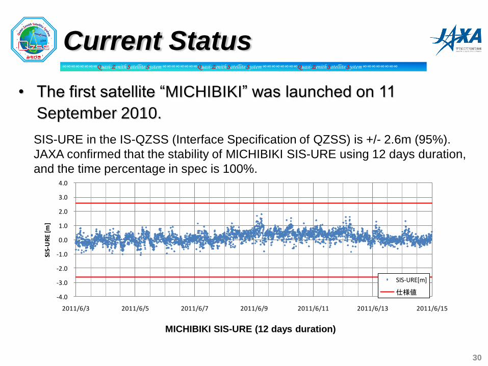
• The first satellite “MICHIBIKI” was launched on 11
September 2010.
SIS-URE in the IS-QZSS (Interface Specification of QZSS) is +/- 2.6m (95%).
JAXA confirmed that the stability of MICHIBIKI SIS-URE using 12 days duration,
and the time percentage in spec is 100%.
MICHIBIKI SIS-URE (12 days duration)
30

∞∞∞∞∞∞∞∞Quasi-Zenith Satellite System ∞∞∞∞∞∞∞∞Quasi-Zenith Satellite System ∞∞∞∞∞∞∞∞Quasi-Zenith Satellite System ∞∞∞∞∞∞∞∞
Accuracy (Combination of GPS + QZSS)
0
1
2
3
4
5
6
7
8
9
10
0 1 2 3 4 5 6 7 8 9 10 11 12 13 14 15 16 17 18 19 20 21 22 23
-5
-4
-3
-2
-1
0
1
2
3
4
5
-5 -4 -3 -2 -1 0 1 2 3 4 5
0
1
2
3
4
5
6
7
8
9
10
0 1 2 3 4 5 6 7 8 9 10 11 12 13 14 15 16 17 18 19 20 21 22 23
Positioning accuracy (m) GPS only GPS+QZSS
Horizontal Average 1.451 1.027
RMS 1.773 1.232
Max 4.885 3.209
Vertical Average 3.204 1.540
RMS 4.122 2.080
Max 9.388 5.828
horizontal (m) vertical (m)
GPS only
GPS+QZSS
@Tokyo (Koganei
monitoring station)
Evaluation conditions - point: Tokyo (Koganei Monitoring Station) - date: 2011/06/03 00:00:00 23:59:30(GPST) - mask elevation angle: 10 degrees - ionospheric correction GPS only:using the parameters from GPS GPS+QZS: using the parameters from QZSS
Improvement
We confirmed the accuracy of the combination of GPS+QZSS improves
because of DOP and good ionospheric correction parameters from MICHIBIKI.
31

∞∞∞∞∞∞∞∞Quasi-Zenith Satellite System ∞∞∞∞∞∞∞∞Quasi-Zenith Satellite System ∞∞∞∞∞∞∞∞Quasi-Zenith Satellite System ∞∞∞∞∞∞∞∞
One Example of Availability Improvement
at Ginza in Tokyo (Feb. 19, 2011)
Date of Observation: 19/02/2011
250 minutes driving observation data
during 6:00-12:30 obtained under JAXA-
Melco joint research experiment
Single Frequency DGPS positioning
Availability
Reference trajectry (measured by MMS)
Positioning result for GPS+QZSS combining use
Positioning result for GPS standalone use
GPS:39.5%
GPS+QZSS:69.1%
32
FIG/IAG/UN-GGIM-AP/ICG/LINZ Technical Seminar
Vertical References Frame in Practice
Christchurch, New Zealand, 1-2 May 2016
Sponsors:
What does multi-GNSS mean for users?
33
FIG/IAG/UN-GGIM-AP/ICG/LINZ Technical Seminar
Vertical References Frame in Practice
Christchurch, New Zealand, 1-2 May 2016
Sponsors:
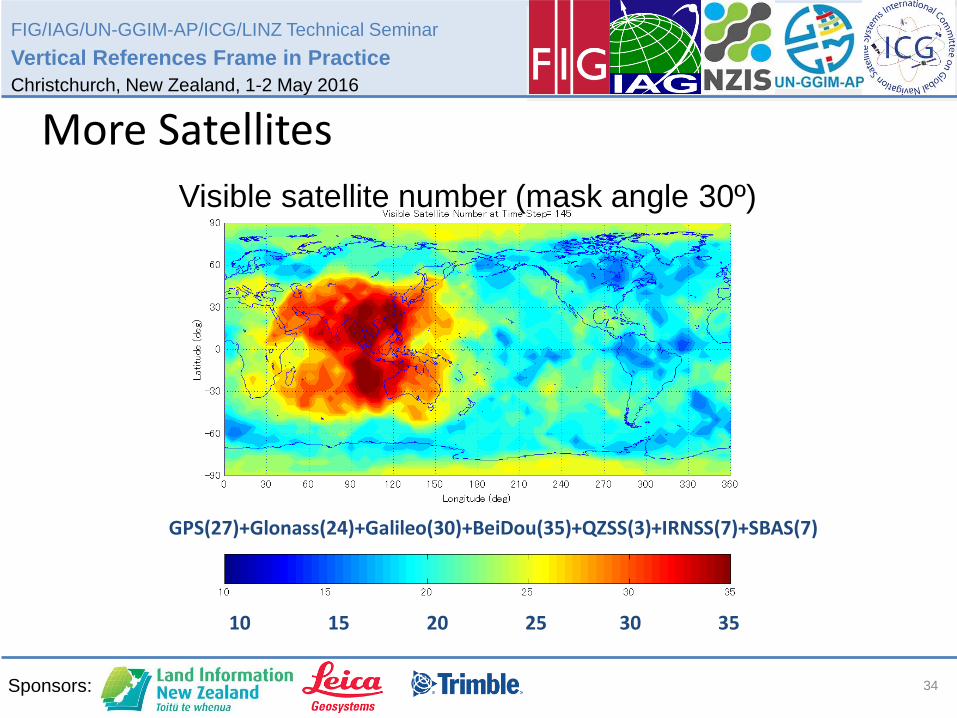
10 15 20 25 30 35
Visible satellite number (mask angle 30º)
GPS(27)+Glonass(24)+Galileo(30)+BeiDou(35)+QZSS(3)+IRNSS(7)+SBAS(7) 2020:
More Satellites
34

FIG/IAG/UN-GGIM-AP/ICG/LINZ Technical Seminar
Vertical References Frame in Practice
Christchurch, New Zealand, 1-2 May 2016
Sponsors: 35

FIG/IAG/UN-GGIM-AP/ICG/LINZ Technical Seminar
Vertical References Frame in Practice
Christchurch, New Zealand, 1-2 May 2016
Sponsors:
2020:
More Signals
36
FIG/IAG/UN-GGIM-AP/ICG/LINZ Technical Seminar
Vertical References Frame in Practice
Christchurch, New Zealand, 1-2 May 2016
Sponsors:
2020:
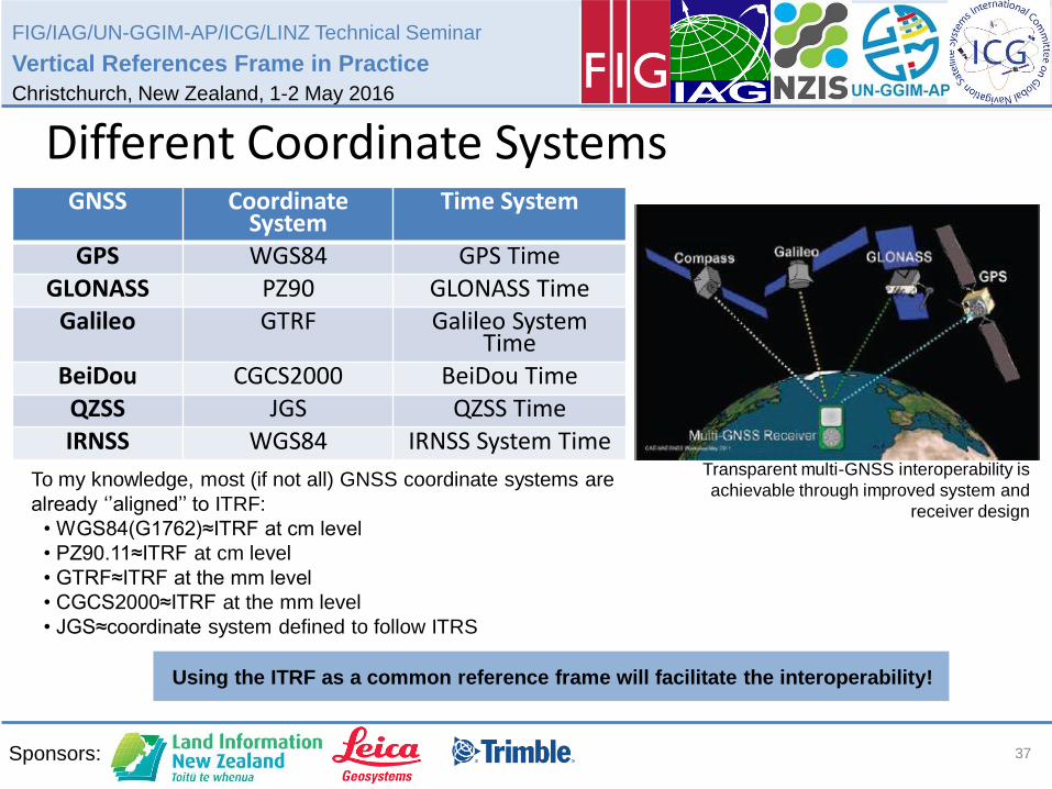
Different Coordinate Systems
Transparent multi-GNSS interoperability is
achievable through improved system and
receiver design
GNSS Coordinate System
Time System
GPS WGS84 GPS Time GLONASS PZ90 GLONASS Time
Galileo GTRF Galileo System Time
BeiDou CGCS2000 BeiDou Time QZSS JGS QZSS Time IRNSS WGS84 IRNSS System Time
To my knowledge, most (if not all) GNSS coordinate systems are
already ‘’aligned’’ to ITRF:
• WGS84(G1762)≈ITRF at cm level
• PZ90.11≈ITRF at cm level
• GTRF≈ITRF at the mm level
• CGCS2000≈ITRF at the mm level
• JGS≈coordinate system defined to follow ITRS
Using the ITRF as a common reference frame will facilitate the interoperability!
37
FIG/IAG/UN-GGIM-AP/ICG/LINZ Technical Seminar
Vertical References Frame in Practice
Christchurch, New Zealand, 1-2 May 2016
Sponsors:
2020:
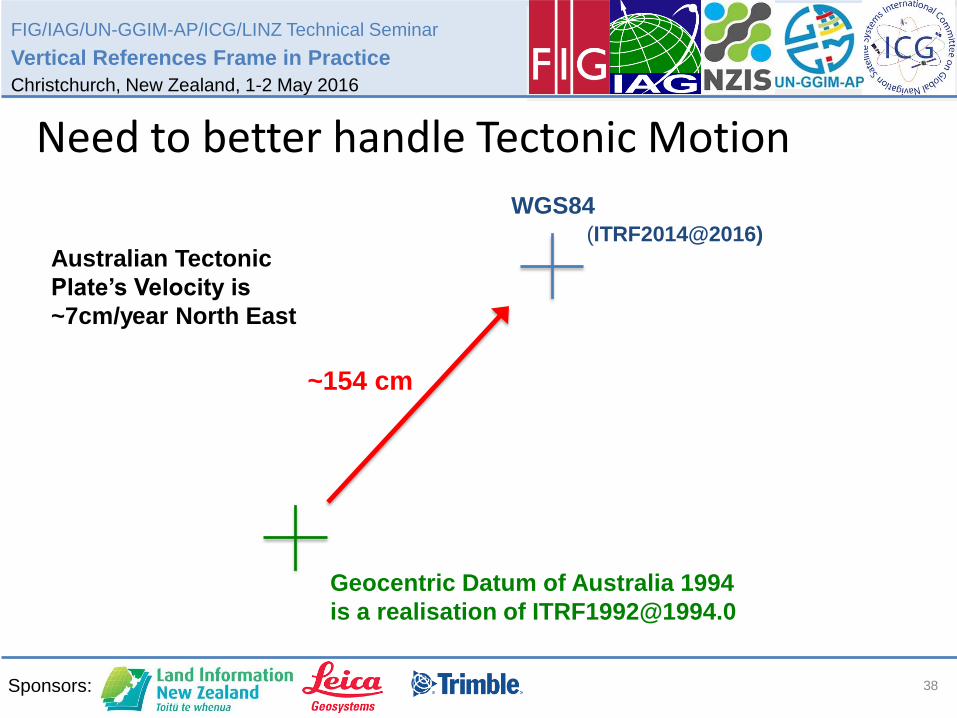
Need to better handle Tectonic Motion
++ +
Australian Tectonic
Plate’s Velocity is
~7cm/year North East
Geocentric Datum of Australia 1994
is a realisation of [email protected]
(ITRF2014@2016)
WGS84
~154 cm
38

FIG/IAG/UN-GGIM-AP/ICG/LINZ Technical Seminar
Vertical References Frame in Practice
Christchurch, New Zealand, 1-2 May 2016
Sponsors:
Thanks for your attention!
39