global change master directory (gcmd) keyword governance and community guide document ... ·...
TRANSCRIPT
Global Change Master Directory (GCMD) Keyword Governance and Community Guide
Document
Version 1.0 August 4, 2016

August 2016
This page intentionally left blank.
3
Global Change Master Directory (GCMD) Keyword Governance and Community Guide Document
August 2016
Reviewed by:
Signature on File
08/04/2016
Stephen W. Wharton Chief, Global Change Data Center GSFC – Code 610.2
Date
Reviewed by:
Signature on File
08/04/2016
Andrew Mitchell ESDIS Deputy Project Manager GSFC – Code 423
Date
Approved by:
Signature on File
08/04/2016
Dawn Lowe ESDIS Project Manager GSFC - Code 423
Date
Goddard Space Flight Center Greenbelt, Maryland
4
This page intentionally left blank.
5
Contents
Contents ................................................................................................................................. 5
Section 1. Scope ..................................................................................................................... 7
Section 2. Benefits of Controlled Keywords ............................................................................ 8 2.1 Overview ................................................................................................................................ 8 2.2 Community Use of the GCMD Keywords ................................................................................. 8
Section 3. GCMD Keyword Change Process .......................................................................... 10 3.1 Definitions ............................................................................................................................... 10 3.2 Roles and Responsibilities ........................................................................................................ 11 3.3 Change Process Overview ........................................................................................................ 12 3.4 Releases and Versioning of GCMD Keyword Changes ............................................................... 15 3.5 Public Notification .................................................................................................................... 15 3.6 Accessing the GCMD Keywords ................................................................................................ 15
Section 4. Overview of Controlled Keywords ........................................................................ 16 4.1 Earth Science Keywords Structure ............................................................................................ 16 4.2 Earth Science Services Keywords Structure ............................................................................... 17 4.3 Data Center Keywords Structure .............................................................................................. 17 4.4 Project Keyword Structure ....................................................................................................... 17 4.5 Instrument/Sensors Keyword Structure ................................................................................... 18 4.6 Platform/Sources Keyword Structure ....................................................................................... 18 4.7 Locations Keyword Structure .................................................................................................... 18 4.8 Horizontal Data Resolution Keyword Structure ........................................................................ 19 4.9 Vertical Data Resolution Keyword Structure ............................................................................. 19 4.10 Temporal Data Resolution Keyword Structure ........................................................................ 19 4.11 URL Content Types Keyword Structure ................................................................................... 20 4.12 Chronostratigraphic Units Types Keyword Structure ............................................................... 20
Section 5. Requirements and Recommendations .................................................................. 21 5.1 Earth Science and Earth Science Services Keyword Requirements ............................................ 21 5.2 Earth Science and Earth Science Services Keyword Recommendations ..................................... 22 5.4 Other Keyword Type Requirements .......................................................................................... 24 5.5 Other Keyword Type Recommendations .................................................................................. 24
Section 6. Resources ......................................................................................................... 26
6
6.1 Contact Information ................................................................................................................. 26 6.2 GCMD ...................................................................................................................................... 26 6.3 ESDIS Standards Office ............................................................................................................. 26 6.4 Other Relevant Resources ........................................................................................................ 27
Appendix A. Organizations Using GCMD Keywords ............................................................... 28
Abbreviations and Acronyms ................................................................................................ 29
7
Section 1. Scope
NASA's Global Change Master Directory (GCMD) holds more than 34,000 Earth science data
set and service descriptions that cover subject areas within the Earth and environmental
sciences. The mission of GCMD is to help researchers, policy makers, and the public find and
access data and related services relevant to global change and Earth science research. Within this
mission, GCMD offers online tools for providers of data and services to facilitate its use by the
Earth science community. In addition, citation information to properly credit data set
contributions is offered, along with direct links to data and services.
The scope of this document includes the governance and review process of the GCMD keyword
vocabularies and a high-level introduction to the keywords. This document is not intended to
provide extensive detail of all internal review processes, specific keyword release
schedules/timelines, associated software, or how the keywords are implemented into software.
August 2016 8
Section 2. Benefits of Controlled Keywords
2.1 Overview An integral part of GCMD’s mission is the development and maintenance of GCMD keywords.
These keywords ensure that metadata are described in a consistent manner and allow for precise
searches of metadata records and subsequent retrieval of data and services. GCMD keywords are
also used in other applications within the broader scientific community. Given the wide adoption
of GCMD keywords within the broader community, it is critically important to document the
processes NASA employs to ensure keywords continue to be relevant to the user and provider
communities and evolve with their changing needs.
The GCMD keywords are organized into 12 sets, (including Earth science keywords, platforms,
instruments, data centers, locations, projects, services, and data resolution) described in Section
4. The term controlled refers to keywords that are predefined in a precise manner and
continually evaluated for their usefulness and logical consistency in relation to the other
keywords. Initiated over 20 years ago, these controlled GCMD keywords will be periodically
analyzed for relevancy and will continue to be refined and expanded in response to user needs
following the governance process defined in this document.
Unless otherwise stated, the terms GCMD keywords and keywords should be understood to mean
the controlled keywords that comprise the keyword vocabularies defined and maintained
specifically by GCMD.
A citation should be referenced when using GCMD keywords in scientific literature, websites,
software tools, etc. Citation guidance and text is available on the GCMD Keyword Forum
(Section 6.2).
2.2 Community Use of the GCMD Keywords NASA’s Earth Observing System Data and Information System (EOSDIS) as well as numerous
other U.S. and international agencies, research universities, and scientific institutions use GCMD
keywords as an authoritative vocabulary, taxonomy, or thesaurus to describe Earth science data,
services, and visualizations. Many of these organizations also use GCMD keywords to create
August 2016 9
ontologies for the Semantic Web, and to search and access Earth science data within online
metadata catalogues. A representative list of organizations using GCMD keywords is shown in
Appendix B.
August 2016 10
Section 3. GCMD Keyword Change Process
This section describes the processes by which GCMD keywords are modified and enhanced to
address the changing needs of the user and provider communities.
3.1 Definitions
3.1.1 Fast Track Review Process
The fast track review process is an expedited review process (less than five business days) for
proposed changes that are small and have little or no impact on other users and metadata
providers.
3.1.2 Full Review Process
The full review process for proposed GCMD keyword changes is a review process facilitated by
the ESDIS Standards Office (ESO) (see Section 3.2.5) with input from subject matter experts
drawn from the user and provider communities. These reviews take longer to complete and are
used for GCMD keyword changes or changes that have a large impact on existing users.
3.1.3 Notifications
Notifications are how GCMD informs the requestor, other stakeholders, and the general public
on the status of GCMD keyword changes or enhancements. Notifications will be posted to the
GCMD Keyword Forum (Section 6.2).
3.1.4 Impact Assessment
The impact assessment refers to a document that describes a proposed change to GCMD
keywords, the rationale, and the potential impact of the change. Specifically, the impact
assessment:
§ Identifies the proposed change as an addition, modification, or deletion § Quantifies the number of collection and granule (if any) metadata records affected
by a change § Identifies the providers affected by a change § Describes the impact a proposed change will have on the metadata records and/or
providers
August 2016 11
3.2 Roles and Responsibilities This section describes the roles and responsibilities of the user community, metadata providers,
GCMD science coordinators, and the ESDIS Standards Office.
3.2.1 User Community
The user community includes individuals and organizations that use GCMD keywords for search, discovery, or access of metadata; as well as individuals and organizations that use GCMD keywords for their own uses.
3.2.2 Metadata Providers
The metadata providers are individuals or organizations that contribute metadata using GCMD keywords for their Earth science data products.
3.2.3 GCMD Science Coordinators
GCMD science coordinators are GCMD personnel with science metadata expertise who review/coordinate recommendations for keyword additions, modifications, or identifying terms no longer recommended for use by the user community and metadata providers; and develop new and updated controlled keyword lists based on the best practices and requirements listed below. GCMD science coordinators periodically review existing keywords and prioritize keyword releases based on input from users, metadata providers, and the ESDIS Standards Office (see Section 3.2.5).
3.2.4 Requestor
The requestor is the person or organization that submits a proposal for an addition, modification, or deletion to the GCMD keywords. A requestor can be from the user community, a metadata provider, a GCMD Science Coordinator, or any other GCMD stakeholder.
3.2.5 Subject Matter Expert (SME)
A subject matter expert (SME) is an expert that participates in the GCMD keyword review process (see Section 3.3) because of his or her knowledge and understanding in areas relevant to the requested changes. SMEs may be drawn from the user community, metadata providers, or internal GCMD/ESDIS staff.
August 2016 12
3.2.6 Earth Science Data and Information System (ESDIS) Project
The ESDIS Project manages the Earth Observing System Data and Information System including
GCMD and has the final authority and approval responsibility for all GCMD keyword changes.
3.2.7 ESDIS Standards Office
The ESDIS Standards Office (ESO) assists the ESDIS Project in formulating standards policy for NASA Earth Science Data Systems (ESDS), coordinates standards activities within ESDIS, and provides technical expertise and assistance to standards related tasks. The ESO facilitates any full community reviews of keyword changes and makes recommendations to ESDIS for final approval of the keyword changes based on feedback received from the community reviews.
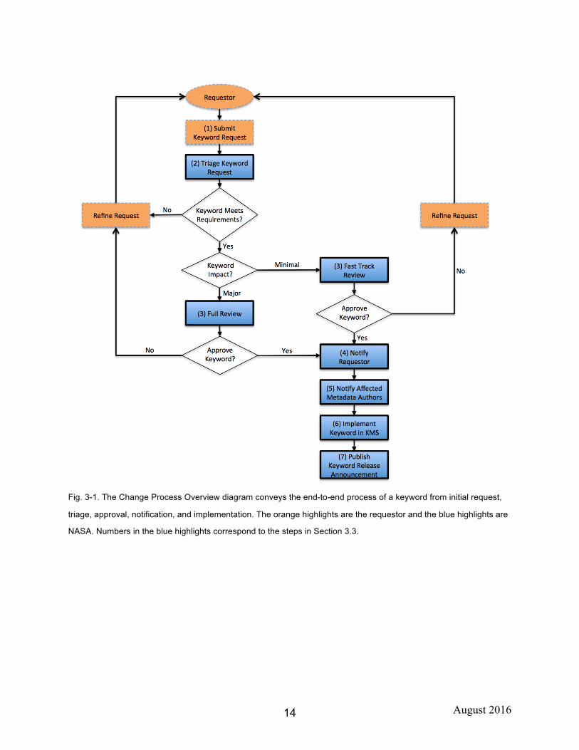
3.3 Change Process Overview The process for submitting proposed changes to the GCMD keywords list is below. See diagram in Fig. 3-1.
1. The requestor submits a request to add, modify, or delete a keyword.
i. For proposing new keywords, the requestor verifies that the proposed keyword does not already exist in the science keyword hierarchy. For proposing keyword modifications or deletions, the requestor must verify the keyword currently exists.
ii. For new keywords, the requestor reviews the GCMD keyword requirements and recommendations (Section 5), confirms the proposed keyword meets all requirements, and provides a definition of the new keyword.
iii. The requestor provides a written request to add or modify one or more keywords and must include complete definitions of those keywords. The request should be sent by email to [email protected].
iv. In some instances, the requestor may be asked to provide additional justification for the keyword request.
v. The requestor receives an acceptance or rejection of the new keyword(s) or suggested modification(s), and may accept or decide to withdraw the proposed change(s). The requestor may check the status of any proposed change through the keyword forum.
vi. Accepted changes will be made available to the public through the GCMD Keyword Forum (Section 6.2).
2. GCMD science coordinators log and triage the request based on keyword requirements
and generate a keyword impact assessment (see Section 3.1.4).
3. Based upon the impact assessment, GCMD science coordinators recommend one of two review processes: a fast-track review for small changes with minimal or no
August 2016 13
impact, or for larger, more impactful changes, a more extensive, full review facilitated by the ESO with participation by community SMEs.
4. GCMD science coordinators will provide an email notification to the requestor of the approval status once the change has been accepted or rejected.
5. GCMD science coordinators will provide a notification to all affected metadata authors of proposed changes to their metadata records.
6. GCMD science coordinators will implement the keyword change in the Keyword Management System (KMS) database.
7. GCMD science coordinators will publish a keyword release announcement on the GCMD Keyword Forum.
August 2016 14
Fig. 3-1. The Change Process Overview diagram conveys the end-to-end process of a keyword from initial request,
triage, approval, notification, and implementation. The orange highlights are the requestor and the blue highlights are
NASA. Numbers in the blue highlights correspond to the steps in Section 3.3.

August 2016 15
3.4 Releases and Versioning of GCMD Keyword Changes GCMD keyword changes are implemented on an incremental basis according to the process
described above in Section 3.3. The frequency of these releases depends on the frequency,
number, and complexity of the keyword change requests received. In addition, full GCMD
keyword releases representing a complete snapshot of the GCMD keywords to date are released
periodically, at least on an annual basis. Full GCMD keywords list releases get a new major
version number (e.g., 8.0). Incremental releases for updates to topics, terms, and variables get a
new minor version number (e.g., 8.1).
3.5 Public Notification To be as transparent as possible in the keyword review process and ensure that the user
community has access to documents that are produced, all keyword reviews, recommendation
reports, keyword change reports, and keyword release announcements will be posted on the
GCMD Keyword Forum (Section 6.2).
3.6 Accessing the GCMD Keywords The Keyword Management Service (KMS) is a web service for maintaining the GCMD
keywords in the GCMD system. It allows users to access the keywords and associated definitions
using a system known as Simple Knowledge Organization System (SKOS) concepts. SKOS is a
standard used for representation of thesauri, classification schemes, taxonomies, subject-heading
systems, or any other type of controlled vocabulary. The KMS provides access to the GCMD
keywords via:
• http://gcmdservices.gsfc.nasa.gov/static/kms/ - GCMD Keyword Directory • http://gcmdservices.gsfc.nasa.gov/kms/capabilities - Dynamic RESTful Service
August 2016 16
Section 4. Overview of Controlled Keywords
There are 12 sets of GCMD keywords managed by the science coordinators. These are:
1. Earth Science 2. Earth Science Services 3. Data Centers 4. Projects 5. Instrument/Sensors 6. Platforms/Sources 7. Locations 8. Horizontal Data Resolution 9. Vertical Data Resolution 10. Temporal Data Resolution 11. URL Content Types 12. Chronostratigraphic Units
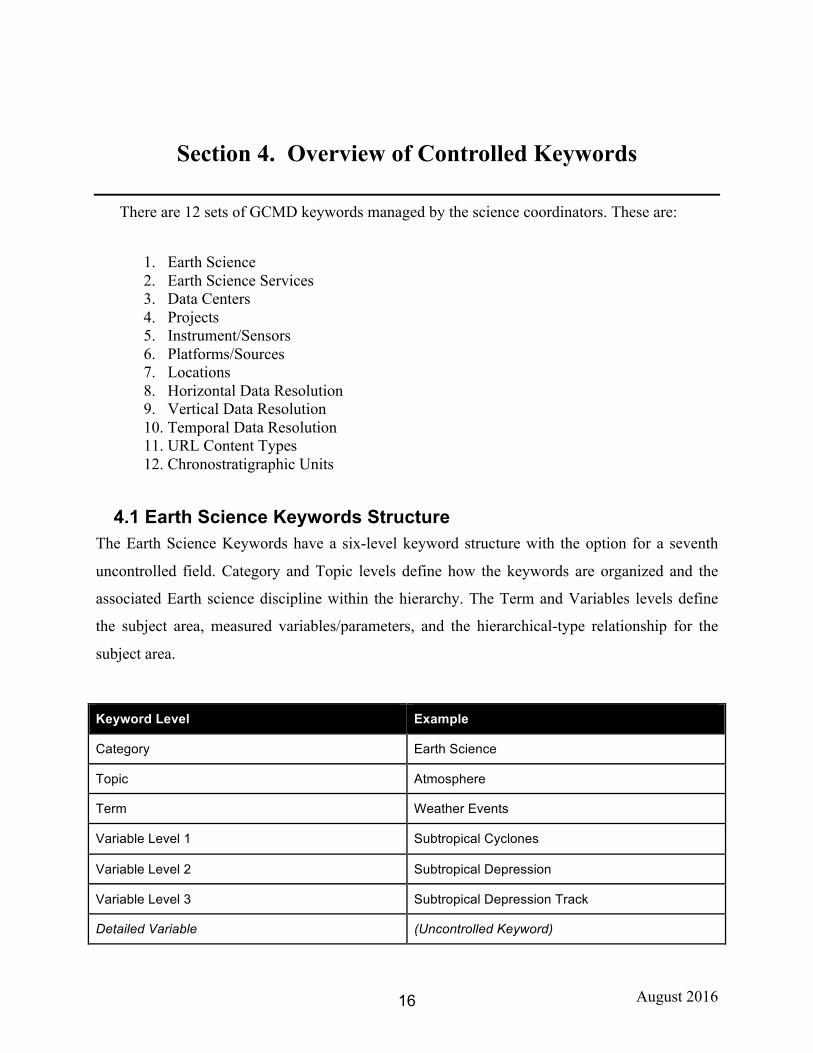
4.1 Earth Science Keywords Structure The Earth Science Keywords have a six-level keyword structure with the option for a seventh
uncontrolled field. Category and Topic levels define how the keywords are organized and the
associated Earth science discipline within the hierarchy. The Term and Variables levels define
the subject area, measured variables/parameters, and the hierarchical-type relationship for the
subject area.
Keyword Level Example
Category Earth Science
Topic Atmosphere
Term Weather Events
Variable Level 1 Subtropical Cyclones
Variable Level 2 Subtropical Depression
Variable Level 3 Subtropical Depression Track
Detailed Variable (Uncontrolled Keyword)
August 2016 17
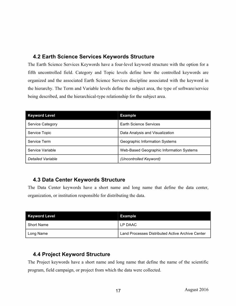
4.2 Earth Science Services Keywords Structure The Earth Science Services Keywords have a four-level keyword structure with the option for a
fifth uncontrolled field. Category and Topic levels define how the controlled keywords are
organized and the associated Earth Science Services discipline associated with the keyword in
the hierarchy. The Term and Variable levels define the subject area, the type of software/service
being described, and the hierarchical-type relationship for the subject area.
Keyword Level Example
Service Category Earth Science Services
Service Topic Data Analysis and Visualization
Service Term Geographic Information Systems
Service Variable Web-Based Geographic Information Systems
Detailed Variable (Uncontrolled Keyword)
4.3 Data Center Keywords Structure The Data Center keywords have a short name and long name that define the data center,
organization, or institution responsible for distributing the data.
Keyword Level Example
Short Name LP DAAC
Long Name Land Processes Distributed Active Archive Center
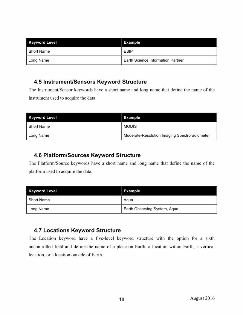
4.4 Project Keyword Structure The Project keywords have a short name and long name that define the name of the scientific
program, field campaign, or project from which the data were collected.
August 2016 18
Keyword Level Example
Short Name ESIP
Long Name Earth Science Information Partner
4.5 Instrument/Sensors Keyword Structure The Instrument/Sensor keywords have a short name and long name that define the name of the
instrument used to acquire the data.
Keyword Level Example
Short Name MODIS
Long Name Moderate-Resolution Imaging Spectroradiometer
4.6 Platform/Sources Keyword Structure The Platform/Source keywords have a short name and long name that define the name of the
platform used to acquire the data.
Keyword Level Example
Short Name Aqua
Long Name Earth Observing System, Aqua
4.7 Locations Keyword Structure The Location keyword have a five-level keyword structure with the option for a sixth
uncontrolled field and define the name of a place on Earth, a location within Earth, a vertical
location, or a location outside of Earth.
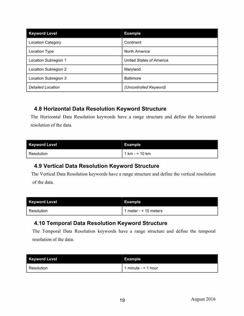
August 2016 19
Keyword Level Example
Location Category Continent
Location Type North America
Location Subregion 1 United States of America
Location Subregion 2 Maryland
Location Subregion 3 Baltimore
Detailed Location (Uncontrolled Keyword)
4.8 Horizontal Data Resolution Keyword Structure The Horizontal Data Resolution keywords have a range structure and define the horizontal
resolution of the data.
Keyword Level Example
Resolution 1 km - < 10 km
4.9 Vertical Data Resolution Keyword Structure The Vertical Data Resolution keywords have a range structure and define the vertical resolution
of the data.
Keyword Level Example
Resolution 1 meter - < 10 meters
4.10 Temporal Data Resolution Keyword Structure The Temporal Data Resolution keywords have a range structure and define the temporal
resolution of the data.
Keyword Level Example
Resolution 1 minute - < 1 hour
August 2016 20
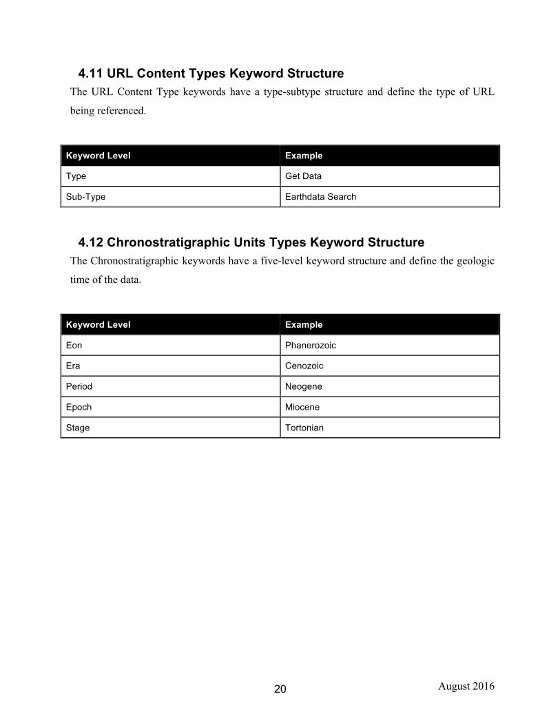
4.11 URL Content Types Keyword Structure The URL Content Type keywords have a type-subtype structure and define the type of URL
being referenced.
Keyword Level Example
Type Get Data
Sub-Type Earthdata Search
4.12 Chronostratigraphic Units Types Keyword Structure The Chronostratigraphic keywords have a five-level keyword structure and define the geologic
time of the data.
Keyword Level Example
Eon Phanerozoic
Era Cenozoic
Period Neogene
Epoch Miocene
Stage Tortonian
August 2016 21
Section 5. Requirements and Recommendations
5.1 Earth Science and Earth Science Services Keyword Requirements
The following are requirements for submitting change requests specifically for Earth Science or
Earth Science Service keywords:
1. Keywords should be applicable to an established science discipline and practical to a broad range of users and metadata providers.
2. Keywords should be composed of conventional terminology that is functional and understandable by the international community.
3. Keywords should not overlap with keywords that already exist.
4. Keywords should only be considered if applicable to existing or forthcoming Earth
science data/metadata (e.g., a new project, instrument, mission, or collaboration).
5. Keywords must be parallel in scope at any level of the hierarchy.
Example: a broad and narrow keyword should not be included within the same level of the hierarchy.
6. All proposed topics, terms, and variables, at any level within the hierarchy, must be distinctive by minimizing overlap as much as possible. This will ensure a concise keyword list.
7. Keywords in the hierarchy should be logically/semantically correct.
8. Keywords should be English words, and when the English word has an alternate British
spelling, the American spelling is used.
Example: Sulfur
9. Terms must be prefixed with topic-level modifiers, if they do not "stand alone" well. This will ensure the term is clear to the user.
Example: Under “Atmosphere” topic, use “Atmospheric Winds” instead of “Winds” as the term.
August 2016 22
10. Terms/Variables should use the plural form when singular versus plural is in question.
11. "Data center-specific" or other “user specific” pre- or suffixed variables should be used as uncontrolled detailed variables, not incorporated into the controlled keyword list — as the broad user community may not understand these variables.
Example: CLIMATE_Total-Precipitable-Water.
12. Count nouns (entities that can be counted) answering the question "How many?" are
plural.
Example: chemical reactions, penguins, ecosystems. Note: exceptions to this rule exist on a discipline-specific basis.
13. Noncount nouns (entities that can’t be counted) answering the question "How much?” are
singular.
Example: ice, heat, snow, water, digestion are singular.
14. Chemical symbols are to be used at Variable_Level2 or Variable_Level3 or as detailed variables. They are too specific to be used at the topic, term, or Variable_Level1 level.
5.2 Earth Science and Earth Science Services Keyword Recommendations
The following are strongly encouraged recommendations for submitting change requests specifically for Earth Science or Earth Science Service keywords. GCMD Science Coordinators will work with requestors to apply these recommendations in a mutually agreeable way, where applicable.
1. Variables should be prefixed with term-level modifiers to identify variables that do not "stand alone" well.
Example: A generic variable such as “motion” should not be used if a more accurate and descriptive variable such as “sea ice motion” can be specified. Note: With few exceptions, variables should not generally be prefixed with topic-level modifiers.
2. Statistical modifiers should be used at Variable_Level2 or Variable_Level3 or captured
as detailed variables. They are too specific to be used at the topic, term, or Variable_Level1 level.
Example: “mean stream discharge”
August 2016 23
3. Extended modifiers should be reserved for Variable_Level2, Variable_Level3, or
captured in the uncontrolled (detailed variable) keyword list. They are too specific to be used at the topic, term, or Variable_Level1 level.
Example: “Integrated Precipitable Water Vapor” or "Intercepted Photosynthetically Active Radiation”
4. If a generic variable has been used to describe a set of measured variables, a repetitive
generic term should not be used at the same level of the variable list.
Example: variable = water vapor; do not use “humidity” at the same level. 5. When multiple expressions for the same variable exist, the variable level should indicate
these as "xxx Expressions," signifying that the expressions following can be used interchangeably with appropriate conversions.
Example: Values that can be converted from one expression to another: absolute humidity; specific humidity; relative humidity; vapor pressure; and mixing ratio should be listed at the variable level below the common identifier, “Water Vapor Expressions.”
6. Duplicate variables should be avoided if one serves as an understatement or surrogate for
another.
Example: soil moisture versus soil water content 7. Variable descriptors that add only vague additional information should be avoided.
Example: lower troposphere
8. Any slash (/) contained in a keyword must be structured so that each side of the slashed
word(s) can stand alone during a search.
Example: i. Use: Atmosphere > Atmospheric Radiation > Optical Depth/Optical
Thickness ii. Do Not Use: Atmosphere > Atmospheric Radiation > Optical
Depth/Thickness
9. Modifiers that only describe the spatial domain should generally be reserved for Variable_Level2 or Variable_Level3.
August 2016 24
Example: Variable = Heat Flux; Variable Level 2 or 3 = Global Heat Flux). 10. Keywords should not be associated with value judgments.
Example: air quality rather than pollution.
11. If the science community uses terms interchangeably, the more commonly used variable
in the field should be employed.
Example: Planetary Boundary Layer (PBL) or Atmospheric Boundary Layer (ABL) should be used in place of peplosphere, which should be reserved for the Detailed Variable level.
12. Keywords that are frequently part of free-text searches, but that do not already exist, are
often good candidates for new keywords.
13. Keywords that are commonly populated in the uncontrolled Detailed Variables field will be considered for inclusion into the controlled GCMD keywords.
5.4 Other Keyword Type Requirements The following are requirements for submitting change requests specifically for other keyword
types, namely Data Centers, Locations, Instruments/Sensors, Platforms/Sources, and Projects:
1. A unique short name must be provided (note: a long name is recommended). The exception is for other keywords that do not have the short name/long name structure but use the more structured hierarchy (example: location keywords).
5.5 Other Keyword Type Recommendations The following are strongly encouraged recommendations for submitting change requests
specifically for other keyword types namely, Data Centers, Locations, Instruments/Sensors,
Platforms/Sources, and Projects:
1. A review of the keyword naming convention by the science coordinators is recommended
to ensure consistency among keyword types.
2. Keywords should use the following naming convention:
August 2016 25
• Short name: abbreviated version of the keyword – MODIS • Long name: standard name of the keyword
Example: Moderate Resolution Imaging Spectroradiometer – MODIS Example: INPE/DAE/FISAT
3. Data Center keywords should follow the recommended naming convention used by the
data center.
4. Data centers, part of a larger organization, may have a compound short name comprised of the organization short name and the data center short name.
5. Location keywords should follow a standard gazetteer or location name standard. The
GCMD location keywords are a superset of the International Organization for Standardization (ISO) location names.
Example: Maymmar (from ISO 3166) Example: Italy (from World Factbook) Example: Ross Sea (from Standing Committee on Antarctic Data Management)
6. Instrument and Platform keywords should follow the recommended naming convention
used by the associated instrument teams; and if part of a series, it should be broken out into multiple keywords.
Example: Platform: Landsat-1, Landsat-2. Instrument: SIR-A, SIR-B
7. Project keywords should follow the recommended naming convention used by the data center and/or the project team; and if part of a series, it should be broken out into multiple projects.
Example: ACE-1, ACE-2
8. Other keyword types should follow the existing naming convention.
Example: URL Content Types, Data Resolution
August 2016 26
Section 6. Resources
6.1 Contact Information For additional information, questions, or concerns regarding the GCMD keywords, email
6.2 GCMD Keyword Forum The purpose of this forum is to provide keyword users and metadata providers with an area
for discussion of topics related to GCMD keywords. The forum, available at
earthdata.nasa.gov/gcmd-forum, contains:
• Keyword change requests and status • Lists of GCMD Controlled Keywords • Organizations using GCMD keywords • Information on the GCMD Keyword Management Service • Organizations using GCMD keywords • Earth Science Keyword Structure • Earth Sciences Service Keyword Structure • General announcements about GCMD keyword updates
Global Change Master Directory (GCMD) Home page
• gcmd.nasa.gov
6.3 ESDIS Standards Office Online:
• General information about the ESDIS Standards Office (ESO), including a list of approved standards and practices, and status of current reviews:
o earthdata.nasa.gov/eso
Email Lists: • General inquiries: [email protected]
August 2016 27
6.4 Other Relevant Resources Online: • General information about EOSDIS and the ESDIS Project:
o earthdata.nasa.gov
• General information about the Common Metadata Repository:
o earthdata.nasa.gov/cmr Email Lists: • Common Metadata Repository announcements:
August 2016 28
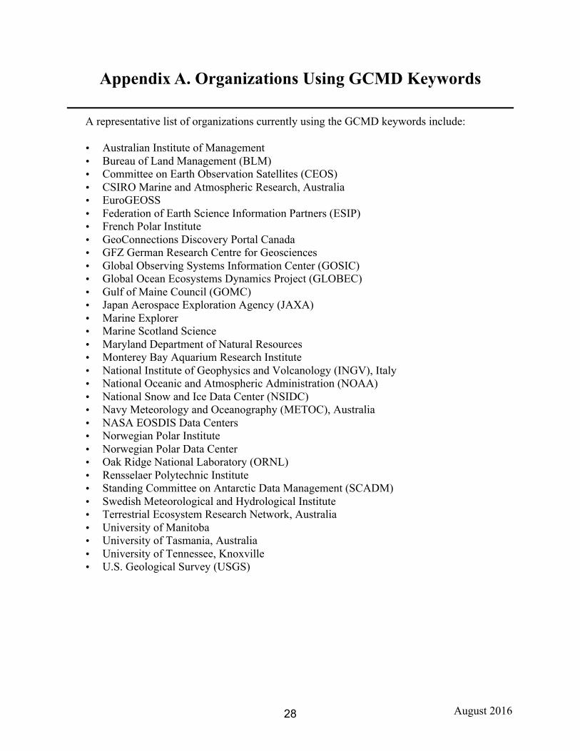
Appendix A. Organizations Using GCMD Keywords
A representative list of organizations currently using the GCMD keywords include:
• Australian Institute of Management • Bureau of Land Management (BLM) • Committee on Earth Observation Satellites (CEOS) • CSIRO Marine and Atmospheric Research, Australia • EuroGEOSS • Federation of Earth Science Information Partners (ESIP) • French Polar Institute • GeoConnections Discovery Portal Canada • GFZ German Research Centre for Geosciences • Global Observing Systems Information Center (GOSIC) • Global Ocean Ecosystems Dynamics Project (GLOBEC) • Gulf of Maine Council (GOMC) • Japan Aerospace Exploration Agency (JAXA) • Marine Explorer • Marine Scotland Science • Maryland Department of Natural Resources • Monterey Bay Aquarium Research Institute • National Institute of Geophysics and Volcanology (INGV), Italy • National Oceanic and Atmospheric Administration (NOAA) • National Snow and Ice Data Center (NSIDC) • Navy Meteorology and Oceanography (METOC), Australia • NASA EOSDIS Data Centers • Norwegian Polar Institute • Norwegian Polar Data Center • Oak Ridge National Laboratory (ORNL) • Rensselaer Polytechnic Institute • Standing Committee on Antarctic Data Management (SCADM) • Swedish Meteorological and Hydrological Institute • Terrestrial Ecosystem Research Network, Australia • University of Manitoba • University of Tasmania, Australia • University of Tennessee, Knoxville • U.S. Geological Survey (USGS)
August 2016 29
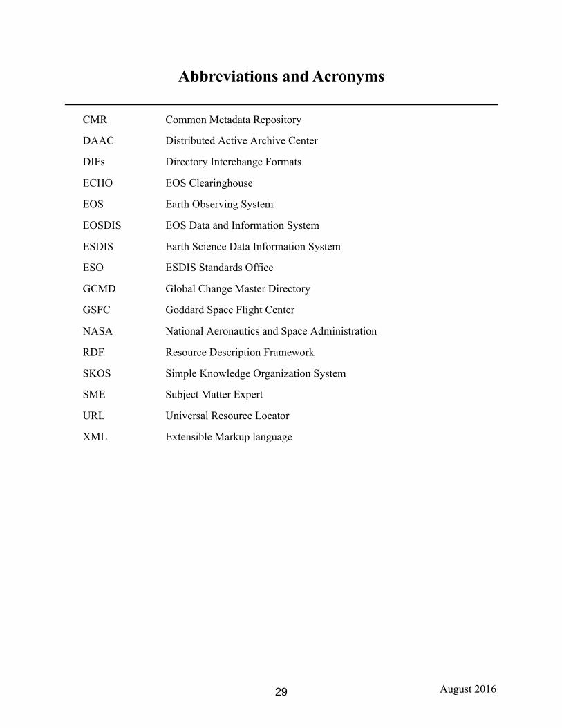
Abbreviations and Acronyms
CMR Common Metadata Repository
DAAC Distributed Active Archive Center
DIFs Directory Interchange Formats
ECHO EOS Clearinghouse
EOS Earth Observing System
EOSDIS EOS Data and Information System
ESDIS Earth Science Data Information System
ESO ESDIS Standards Office
GCMD Global Change Master Directory
GSFC Goddard Space Flight Center
NASA National Aeronautics and Space Administration
RDF Resource Description Framework
SKOS Simple Knowledge Organization System
SME Subject Matter Expert
URL Universal Resource Locator
XML Extensible Markup language