gleason lake subwatershed plan
TRANSCRIPT

Gleason Lake Subwatershed Plan
Minnehaha Creek Watershed District Water Resources Management Plan
April 2007
T:\0185\ 4315 2005 Plan Revision\2005 WRMP\Report\Final Report\Subwatershed Plans Word\FINAL Gleason Lake Plan.doc

Table of Contents
1.0 INTRODUCTION AND SUMMARY............................................................................. 1
2.0 LAND AND WATER RESOURCES INVENTORY .................................................... 2 2.1 Location .................................................................................................................. 2
2.2 Physical Environment ............................................................................................. 2 2.2.1 Topography and Drainage....................................................................................... 2 2.2.2 Geology and Soils ................................................................................................... 2 2.2.3 Unique Features and Scenic Areas ......................................................................... 7
2.3 Biological Environment .......................................................................................... 7 2.3.1 Vegetation ............................................................................................................... 7 2.3.2 Biologic Integrity .................................................................................................... 7
2.4 Human Environment............................................................................................. 11 2.4.1 Present Land Use .................................................................................................. 11 2.4.2 2020 and 2030 Land Use Planning ....................................................................... 11 2.4.3 Aquatic Recreation................................................................................................ 11
2.5 Hydrologic Systems .............................................................................................. 16 2.5.1 Lakes ..................................................................................................................... 16 2.5.2 Streams.................................................................................................................. 17 2.5.3 Ditches .................................................................................................................. 18 2.5.4 Wetlands ............................................................................................................... 18 2.5.5 Floodplain ............................................................................................................. 20 2.5.6 Groundwater ......................................................................................................... 20
3.0 PROBLEMS AND ISSUES............................................................................................ 29 3.1 Water Quality........................................................................................................ 29
3.2 Water Quantity...................................................................................................... 29
3.3 Wetlands ............................................................................................................... 30
3.4 Ecological Integrity............................................................................................... 30
3.5 Groundwater ......................................................................................................... 30
3.6 Impacts of Future Growth..................................................................................... 31
4.0 RESOURCE MANAGEMENT GOALS AND STRATEGIES.................................. 32 4.1 Infiltration/Filtration ............................................................................................. 32
4.2 Ecological Integrity............................................................................................... 34
4.3 Water Quality........................................................................................................ 36
4.4 Public Health......................................................................................................... 38

4.5 Water Quantity...................................................................................................... 40
4.6 Shorelines and Streambanks ................................................................................. 41
4.7 Navigation............................................................................................................. 43
4.8 Best Management Practices .................................................................................. 43
4.9 Education and Communications ........................................................................... 44
4.10 Ditches .................................................................................................................. 45
4.11 Wetlands ............................................................................................................... 46
4.12 Groundwater ......................................................................................................... 48
4.13 Floodplains............................................................................................................ 49
4.14 Recreation ............................................................................................................. 50
4.15 Erosion Control..................................................................................................... 51
4.16 Regulation............................................................................................................. 52
4.17 Public Involvement ............................................................................................... 53
5.0 IMPLEMENTATION PROGRAM .............................................................................. 56 5.1 Regulatory Program.............................................................................................. 56
5.2 Land Conservation Program ................................................................................. 57
5.3 Education Program................................................................................................ 57
5.4 Monitoring and Data Collection ........................................................................... 57
5.5 Operations and Maintenance................................................................................. 58
5.6 LGU Requirements ............................................................................................... 59 5.6.1 Local Government Unit Subwatershed Phosphorus Load Reductions ................. 59 5.6.2 Land Conservation ................................................................................................ 59 5.6.3 Other Issues........................................................................................................... 60
5.7 Phosphorus Load Reduction ................................................................................. 60
5.8 Capital Improvement Program.............................................................................. 61 5.8.1 Gleason Lake Pond at Lake Inlet .......................................................................... 62 5.8.2 Detention Pond Upstream of CR 6 ....................................................................... 62 5.8.3 Gleason Lake Management Plan Projects............................................................. 63 5.8.4 Gleason Lake Internal Load Management............................................................ 64 5.8.5 Regional Infiltration.............................................................................................. 65
5.9 Summary ............................................................................................................... 65
TABLES Table 1. Percent of Gleason Lake subwatershed by 2000 land use. ............................................ 11 Table 2. Public Waters in the Gleason Lake subwatershed. ........................................................ 16 Table 3. Modeled peak discharge from the Gleason Lake subwatershed (cfs). .......................... 16 Table 4. Physical characteristics of lakes in the Gleason Lake subwatershed............................. 17

Table 5. Selected water quality goals and current conditions of lakes in the Gleason Lake subwatershed. ................................................................................................................. 17
Table 6. National Wetlands Inventory wetlands in the Gleason Lake subwatershed. ................. 18 Table 7. Dominant wetland type in the Gleason Lake subwatershed as assessed in the Functional
Assessment of Wetlands. ................................................................................................. 19 Table 8. Wetland management classifications of wetlands in the Gleason Lake subwatershed as
determined in the Functional Assessment of Wetlands. ................................................. 19 Table 9. Gleason Lake modeled 2020 and ultimate development water quality and the total
phosphorus loading reduction necessary to achieve in-lake total phosphorus concentration goals. ........................................................................................................ 31
Table 10. Modeled annual volume of runoff in the Gleason Lake subwatershed, and estimated reductions resulting from application of a proposed 1” abstraction rule for new development and redevelopment (acre-feet). ................................................................. 40
Table 11. Ongoing District operations and maintenance tasks in the Gleason Lake subwatershed......................................................................................................................................... 58
Table 12. Operation and maintenance tasks and responsible parties for previously completed Gleason Lake subwatershed improvement projects. ...................................................... 58
Table 13. Potential ongoing operations and maintenance tasks for proposed Gleason Lake subwtaershed improvement projects. ............................................................................. 59
Table 14. Allocation of Gleason Lake subwatershed LGU phosphorus load reductions (lbs/yr)......................................................................................................................................... 59
Table 15. Phosphorus load reduction plan for Gleason Lake. ..................................................... 61 Table 16. Problems and issues identified in the Gleason Lake subwatershed and actions
proposed to address them. .............................................................................................. 66 Table 17. Summary of metrics to be used in evaluating progress toward Gleason Lake
subwatershed goals. ........................................................................................................ 70 Table 18. Summary of Gleason Lake subwatershed implementation program. ......................... 70
FIGURES Figure 1. Gleason Lake Subwatershed Location. ...........................................................................3 Figure 2. Gleason Lake Subwatershed Drainage Areas..................................................................4 Figure 3. Gleason Lake Subwatershed Soil Hydrologic Groups. ...................................................5 Figure 4. Gleason Lake Subwatershed Hydric Soils. .....................................................................6 Figure 5a. Gleason Lake Subwatershed MLCCS Land Cover: Imperviousness ............................8 Figure 6b. Gleason Lake Subwatershed MLCCS Land Cover: Cover Type..................................9 Figure 7. Gleason Lake Subwatershed Natural Resource and Recreation Areas. ........................10 Figure 8. Gleason Lake Subwatershed 2000 Land Use. ...............................................................12 Figure 9. Gleason Lake Subwatershed 2020 Land Use. ...............................................................13 Figure 10. Gleason Lake Subwatershed 2030 Planning Framework............................................14 Figure 11. Gleason Lake Subwatershed Public Waters ................................................................15 Figure 12. Gleason Lake Subwatershed FAW Wetland Type......................................................21 Figure 13. Gleason Lake Subwatershed FAW Wetlands..............................................................22 Figure 14. Gleason Lake Subwatershed High Habitat Value Wetlands. ......................................23 Figure 15. Gleason Lake Subwatershed Wetland Restoration Potential. .....................................24 Figure 16. Gleason Lake Subwatershed Floodplain. ....................................................................25 Figure 17. Gleason Lake Subwatershed Soil Infiltration Potential...............................................26

Figure 18. Gleason Lake Subwatershed Aquifer Sensitivity. .......................................................27 Figure 19. Gleason Lake Subwatershed Wellhead Protection Areas. ..........................................28 Figure 20. Gleason Lake Subwatershed Key Conservation Areas. ..............................................55 Figure 21. Gleason Lake Subwatershed Implementation Plan. ....................................................73

April 2007 Gleason Lake Subwatershed Page 1
1.0 Introduction and Summary
The Gleason Lake subwatershed is located along the northern boundary of the Minnehaha Creek Watershed District (MCWD or District) and within the cities of Plymouth, Wayzata, Orono, and Minnetonka. The subwatershed includes Gleason Lake, several other lakes, Gleason Creek, and numerous wetlands. A county ditch system and other channels drain the upper subwatershed to Gleason Lake, which outlets by Gleason Creek. That creek flows 0.9 miles through channel and culvert to Glenbrook Pond in Wayzata. That pond outlets by a storm sewer that discharges downstream to Wayzata Bay of Lake Minnetonka. Other lakes of interest in the subwatershed include Hadley Lake, Kreatz Lake, and Snyder Lake. Gleason Lake does not meet its water quality goal. No goals were established for the other lakes, and limited data is available to assess their water quality. Gleason Creek conveys high phosphorus and sediment loads downstream. Water quality, lack of habitat, and hydrology limit the ecological integrity of Gleason Creek. Gleason Lake is a moderate quality panfishery, while no fish survey data is available for the other lakes. A limited number of high-value wetlands are present in the subwatershed. Over the next ten years, the District’s focus in the Gleason Lake subwatershed will be on protecting and improving water quality in the lakes and Creek and controlling the volume of stormwater runoff within the subwatershed. The following will be particular focus areas:
• Minimizing impacts on water resources from future development through enhanced regulation that requires higher levels of pollutant removal and increased infiltration of runoff.
• Investigating and improving water quality in Gleason Lake through additional diagnostic study and construction of improvement projects.
• Conserving ecological integrity in the subwatershed through activities in key conservation areas.
• Improving ecological integrity in Gleason Creek through the improvement of its water quality and installation of habitat features.
April 2007 Gleason Lake Subwatershed Page 2
2.0 Land and Water Resources Inventory
2.1 Location The Gleason Lake subwatershed is located along the northern boundary of the MCWD and within the cities of Plymouth, Wayzata, Orono, and Minnetonka (see Figure 1). The Gleason Lake watershed is 3,766 acres in size (almost six square miles). 2.2 Physical Environment 2.2.1 Topography and Drainage
The Gleason Lake subwatershed is located within the Emmons-Faribault moraine geomorphic region, and the topography is typical of that region – gentle rolling hills with an abundance of lakes and ponds. The 2003 MCWD Hydrologic, Hydraulic, and Pollutant Loading Study (HHPLS) subdivided the Gleason Lake subwatershed into sixteen subwatershed units, designated GLC-1 through GLC-11, and HL-1 through HL-5 for that part of the subwatershed that is within the Hadley Lake drainage area (see Figure 2). The eastern portion of the subwatershed drains through several wetlands including Kreatz and Snyder Lakes and then to County Ditch #15, which discharges into Gleason Lake. The western subwatershed drains through Hadley Lake and then south to Gleason Lake Creek, which outlets the south end of Gleason Lake and flows by channel and culvert to Glenbrook Pond. The Pond outlets to a storm sewer that discharges downstream to Wayzata Bay.
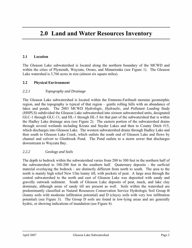
2.2.2 Geology and Soils The depth to bedrock within the subwatershed varies from 200 to 300 feet in the northern half of the subwatershed to 100-200 feet in the southern half. Quaternary deposits - the surficial material overlaying the bedrock - are distinctly different from north to south. The area to the north is mainly high relief New Ulm loamy till, with pockets of peat. A large area through the central subwatershed to the north and east of Gleason Lake was deposited with sandy and gravelly outwash sediment. South of Gleason Lake deposits of peat, muck, and lake clay dominate, although areas of sandy till are present as well. Soils within the watershed are predominantly classified as Natural Resources Conservation Service Hydrologic Soil Group B (loamy soils with moderate infiltration potential) and D (clayey soils with very low infiltration potential) (see Figure 3). The Group D soils are found in low-lying areas and are generally hydric, or showing indications of inundation (see Figure 4).

April 2007 Gleason Lake Subwatershed Page 3

April 2007 Gleason Lake Subwatershed Page 4

April 2007 Gleason Lake Subwatershed Page 5
April 2007 Gleason Lake Subwatershed Page 6 April 2007 Gleason Lake Subwatershed Page 6

April 2007 Gleason Lake Subwatershed Page 7
2.2.3 Unique Features and Scenic Areas
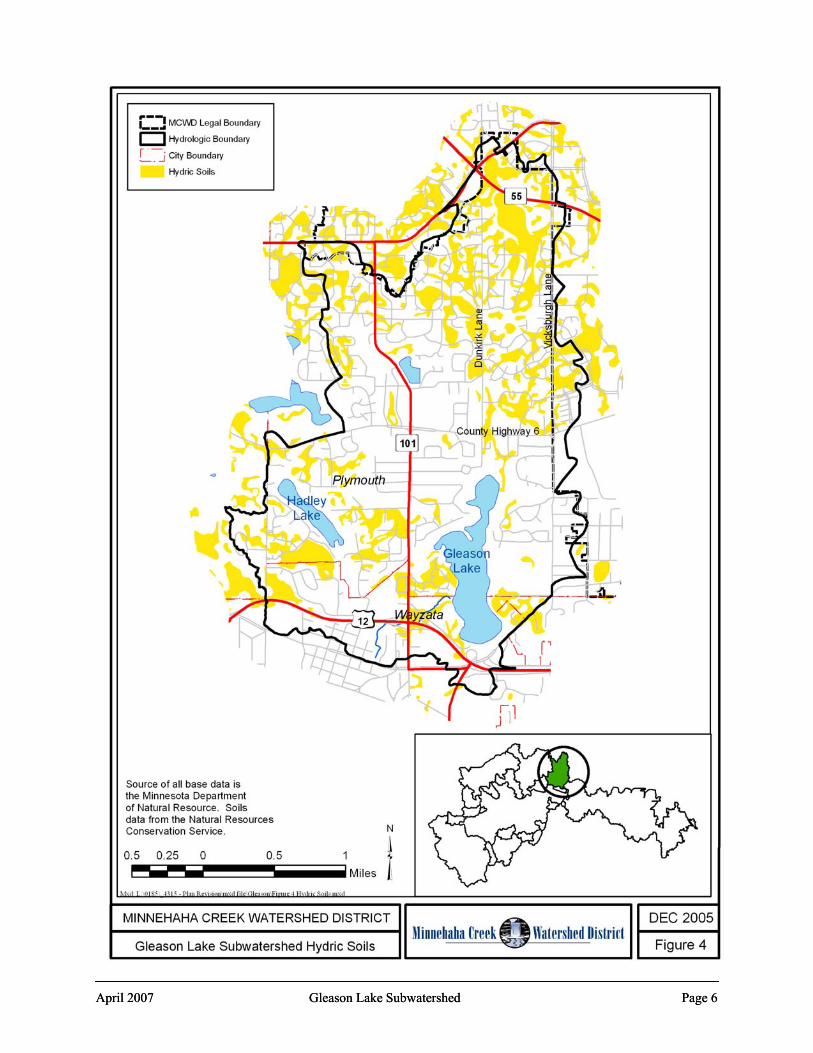
The Luce Line Regional Trail passes through this subwatershed, crossing the north end of Gleason Lake (see Figure 6). Existing data sources do not highlight any other unique or scenic areas in this subwatershed. The Minnesota Historic Features database notes 15 historic features in this subwatershed, all farmhouses or residences
2.3 Biological Environment 2.3.1 Vegetation
Land cover as classified by the Minnesota Land Cover Classification System (MLCCS) (see Figures 5a and 5b) is mostly developed areas with low to medium impervious surface typical of residential development. Pockets of wetlands and wooded areas (mainly park lands) are present. 2.3.2 Biologic Integrity Landscape. The Gleason Lake Creek subwatershed is mostly developed, with few intact areas of minimal disturbance. The Minnesota County Biological Survey did not identify any landscape areas of biological significance in this subwatershed, although just outside of this subwatershed is the Wood-Rill Scientific and Natural Area in Orono. Some wooded and wetland areas around Hadley Lake and a few pocket wetlands and wooded areas elsewhere in the subwatershed provide the most significant areas of habitat and biological integrity. Lakes. The most recent DNR fish survey for Gleason Lake was conducted in 1996. It identified a fishery dominated by bluegills and black crappies. Pumpkinseed sunfish were also found in above-average numbers. Northern pike were abundant. Eurasian water milfoil has been confirmed in Gleason Lake since 1998. An aquatic vegetation survey was completed in 2002 for the Gleason Lake Management Plan. Gleason Lake is almost entirely littoral (less than about 15 feet deep), with extensive aquatic vegetation dominated by coontail. Curly leaf pondweed was detected at one-third of the stations sampled in the lake. The Plan speculated that the dense coontail growth was the likely cause of better-than-expected water clarity because it shades the sediments and prevents photo release of phosphorus. Milfoil was not found to be a concern. Streams. Biological sampling on Gleason Creek was conducted as a part of the Upper Watershed Stream Assessment. Two sites were sampled; only one yielded more than the 100 organisms typically needed to assure sample reliability. The F-IBI – an Index of Biotic Integrity identified to the organism’s family level – fell into the Poor category. Seven taxa of organisms were found, dominated by pollution-tolerant species. Water quality, lack of habitat, and hydrology limit macroinvertebrates in Gleason Creek. Wetlands. Some scattered wetlands were identified in the 2003 MCWD Functional Assessment of Wetlands (FAW) as having high vegetative diversity and wildlife habitat potential as well as having high aesthetic values (see Figure 13). Wetlands riparian to Gleason Lake were noted as important fish habitat.

April 2007 Gleason Lake Subwatershed Page 8

April 2007 Gleason Lake Subwatershed Page 9
April 2007 Gleason Lake Subwatershed Page 10
April 2007 Gleason Lake Subwatershed Page 10

2.4 Human Environment 2.4.1 Present Land Use The predominant land use in the subwatershed is single family residential (see Figure 7). There is a commercial/industrial corridor along TH 55 and Vicksburg Lane in the upper subwatershed, and another commercial node at TH 101 and County Road 6. Some small pockets of undeveloped area remain, mainly large lots.
Table 1. Percent of Gleason Lake subwatershed by 2000 land use.
Land Use 2000 Acres % of Subwatershed
Single Family Residential 2,437.7 64.7% Vacant 376.7 10.0% Water 301.2 8.0% Institutional 198.7 5.3% Parks and Open Space 158.3 4.2% Highway 101.0 2.7% Retail/Office 72.8 1.9% Multi Family 64.3 1.7% Industrial 47.3 1.3% Agricultural 8.3 0.2% 3,766.3 Source: Metropolitan Council. See Figure 7.
2.4.2 2020 and 2030 Land Use Planning Future land use in the subwatershed is not expected to change dramatically by 2020 or 2030 (see Figures 8 and 9, although there will be some infill development and redevelopment. The 2030 Metropolitan Council Planning Framework classifies all of Plymouth as a Developing Area, mainly due to areas outside this subwatershed that are expected to continue to develop. 2.4.3 Aquatic Recreation
There is no public boat access to Gleason Lake. There are no public beaches or parks located on the lake, although the Luce Line Regional Trail does cross the lake on the north (see Figure 6).
April 2007 Gleason Lake Subwatershed Page 11

April 2007 Gleason Lake Subwatershed Page 12

April 2007 Gleason Lake Subwatershed Page 13

April 2007 Gleason Lake Subwatershed Page 14

April 2007 Gleason Lake Subwatershed Page 15

2.5 Hydrologic Systems The Department of Natural Resources’ Public Waters Inventory identifies numerous basins within the Gleason Lake subwatershed as under the jurisdiction of the DNR (see Figure 10). These include Gleason and Hadley Lakes and the following other basins: Table 2. Public Waters in the Gleason Lake subwatershed. Name and DNR ID # Name and DNR ID # Name and DNR ID # Gleason (27-95 P) Unnamed (27-610 W) Unnamed (27-823 W) Hadley (27-109 P) Unnamed (27-611 W) Unnamed (27-824 W) Kreatz (27-467 W) Unnamed (27-612 W) Unnamed (27-825 W) Snyder (27-108 P) Unnamed (27-613 W) Unnamed (27-826 W) Unnamed (27-105 W) Unnamed (27-686 W) Unnamed (27-827 W) Unnamed (27-468 W) Unnamed (27-687 W) Unnamed (27-828 W) Unnamed (27-607 W) Unnamed (27-688 W) Unnamed (27-844 P) Unnamed (27-609 W) Unnamed (27-822 W) Source: Minnesota DNR. See Figure 10. The HHPLS included detailed modeling of the current and 2020 hydraulic and hydrologic conditions in the subwatershed. That modeling includes the following results for modeled locations (lakes, ponds, channels, and crossings) within the subwatershed:
Existing Normal Water Level; Existing High Water Level, peak discharge, and peak velocity for the 1.5 year, 24-hour and 100-
year, 24-hour events; 2020 predicted HWL, peak discharge, and peak velocity for the 100-year, 24-hour event; and the Existing High Water Level for the 100-year, 10-day snowmelt event
Those detailed results are not reproduced here, but are incorporated by reference. The HHPLS model predicted that development in the upper subwatershed expected by 2020 would likely have impacts on local peak flows and volumes (see Figure 2) and volume controls should be considered for all new development. Table 3. Modeled peak discharge from the Gleason Lake subwatershed (cfs).
Event Existing 2020 Snowmelt 1.5 year, 24 hour 53.7 - - 100 year, 24 hour 91.2 92.1 - 100-year, 10-day - - 90.1
Source: 2003 MCWD Hydrologic, Hydraulic, and Pollutant Loading Study (HHPLS) 2.5.1 Lakes Gleason Lake is the primary receiving water within the subwatershed, and is classified by the DNR for shoreland management purposes as a Recreational Development Lake. Tables 4 and 5 below detail the physical and water quality characteristics of Gleason Lake and other lakes within the subwatershed. Since 2000 Gleason Lake has consistently been scored in the C-D grade range on the District’s annual lake report cards. The mean summer 2004 total phosphorus concentration was 104 μg/L, well in excess of the District’s 80 μg/L interim goal and the highest average concentration since 1997. It also exceeds the shallow lake standards being developed by
April 2007 Gleason Lake Subwatershed Page 16

the State of Minnesota and is in an impaired use condition, although it has not been formally designated an Impaired Water. Other large water resources in the subwatershed are Hadley, Kreatz and Snyder Lakes. Little or no water quality data is available for those lakes. Table 4. Physical characteristics of lakes in the Gleason Lake subwatershed.
Lake Surface Area Maximum Depth
Watershed to Lake Area Ratio DNR Classification
Gleason 156 16 12:1 Recreational Development
Hadley 33 N/A 6:1 Recreational Development
Kreatz 7 N/A 39:1 Recreational Development
Snyder 10 N/A 37:1 Recreational Development Source: Minnesota DNR Table 5. Selected water quality goals and current conditions of lakes in the Gleason Lake subwatershed.
2004 Lake 1997
TP Goal HHPLS TP Goal
1997-2004 Average
TP TP
(μg/L) Chl-a (μg/L)
Secchi (m) TSI
Gleason 90 80 90 104 23 1.4 62
Hadley 27 * N/A N/A N/A 1-2** N/A
Kreatz N/A * N/A N/A N/A <.5** N/A
Snyder N/A * N/A N/A N/A <.5** N/A *10% reduction from existing, provided it is greater than 25 μg/L ** Clarity as estimated by the University of Minnesota using satellite imagery Source: MCWD and Minnesota DNR/University of Minnesota According to standards established by the MPCA, water quality in Gleason Lake is not supportive of swimming. Modeling performed for the HHPLS and for preparation of this plan indicates that phosphorus loading from runoff in the watershed cannot explain the total phosphorus concentrations in the lake. Internal loading from lake sediments is likely a root cause of the higher than expected in-lake TP concentrations and excessive algal blooms. No water quality modeling was performed for Hadley, Kreatz, and Snyder Lakes as part of the HHPLS. The Regional Team recommended to the Board that baseline data be obtained, and that an appropriate goal would be a ten percent reduction in the in-lake total phosphorus concentration, provided that the existing level was greater than 25 μg/L. Given the water clarity as estimated by satellite imagery, it is likely the concentration is well in excess of 25 μg/L. 2.5.2 Streams There is one primary stream within the subwatershed: Gleason Creek, which serves as the outlet of Gleason Lake and flows to Glenbrook Pond in Wayzata, which is discharged by storm sewer into Wayzata Bay of Lake Minnetonka. Portions of the creek were channelized as County Ditch #32 at some unknown past date. Gleason Creek is included in the District’s Annual Hydrologic Data monitoring program, and was also studied in-depth in 2004 as part of the District’s Upper Watershed Stream Assessment. Flow in the creek is controlled by an outlet weir on Gleason
April 2007 Gleason Lake Subwatershed Page 17

Lake and is mainly runoff event-driven. Eleven storm sewer outfalls discharge into the creek. The creek flows through five culverts at the US Highway 12/TH 101 interchange. Several spot erosion sites were identified. Water quality in the creek is variable and is dependant on flow. Especially during wetter years when erosive flow velocities may occur, Gleason Creek can convey significant total phosphorus (TP) and total suspended sediment (TSS) loads from Gleason Lake to Glenbrook Pond. Dissolved oxygen within the stream is highly dependant on flow, and at low flows falls below the 5 mg/L State of Minnesota standard for class 2B waters.
2.5.3 Ditches Two public drainage ditches established under Minnesota Statutes Chapter 103E are located within this subwatershed. County Ditch #15 drains a large area north of Gleason Lake, ultimately discharging into the lake. Part of Gleason Creek appears to have been channelized as part of County Ditch #32. County Ditch #15. County Ditch #15 was established at some unknown time in the past, likely to drain several wetlands to make them suitable for agriculture. The ditch still exists, and forms an important component of the City of Plymouth’s local drainage system. No agricultural use continues to benefit from the ditch; the land has been subdivided and developed with a variety of suburban uses, including single and multiple family housing, commercial, and industrial uses. A channel erosion survey was conducted as a part of the HHPLS. Several eroded locations were identified. County Ditch #32. County Ditch #32 was established at some unknown time in the past, likely to drain wetlands in the vicinity of the present-day US Highway 12 and TH 101 interchange to make them suitable for agriculture. The ditch is currently an open channel in wetland areas and in culverts under the highway, and is part of the City of Wayzata’s local storm sewer system. No agricultural use continues to benefit from the ditch. 2.5.4 Wetlands
Approximately 14 percent of the land area within the Gleason Lake subwatershed is shown on the National Wetland Inventory as wetland. Table 6. National Wetlands Inventory wetlands in the Gleason Lake subwatershed.
Circular 39 Type Area (acres) Cowardin Class Area (acres)
Seasonal 4.1 Emergent 261.1 Wet Meadow 0.5 Forested 17.3 Shallow Marsh 256.5 Scrub Shrub 16.6 Deep Marsh 16.3 Unconsolidated Bottom 243.6 Open Water 227.3 Scrub Shrub 16.6 Forested 17.3 TOTAL 538.6 538.6 Source: Minnesota DNR.
April 2007 Gleason Lake Subwatershed Page 18

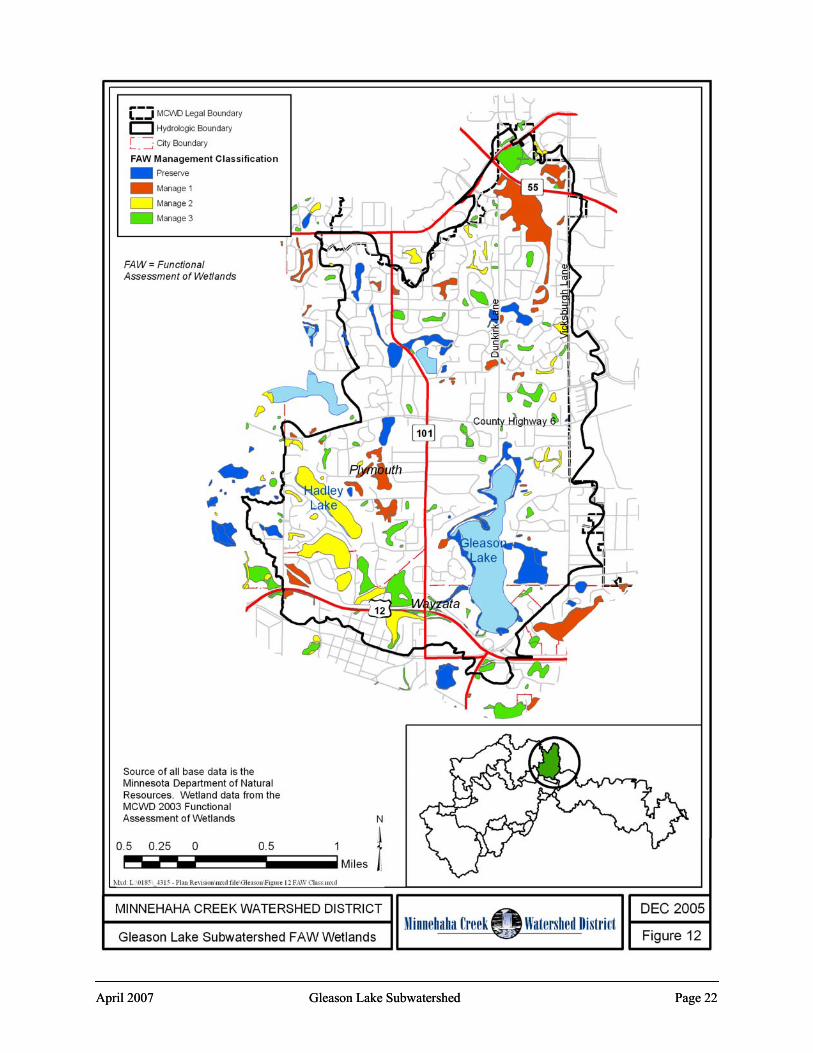
In 2001-2003 the District undertook a Functional Assessment of Wetlands on all wetlands greater than one-quarter acre in size. This assessment used a variant of the Minnesota Routine Assessment Method. In contrast to Table 6 above, which shows wetland acreage and type from the National Wetlands Inventory completed in the 1980s, Table 7 below shows the acreage and type as assessed in the field. Using the results of that analysis, individual wetlands were assigned to one of four categories – Preserve, and Manage 1, 2, or 3 (see Figure 12 and Table 8). Wetlands that were evaluated as Exceptional or High on certain ecological or hydrologic values were assigned to the Preserve category. The balance of evaluated wetlands were assigned to a category based on this assessment of current functions and values, with Manage 1 wetlands exhibiting higher values and Manage 2 and 3 moderate or lower values. Refer to the Functional Assessment of Wetlands (2003) for details of methodology, classification, and management recommendations. Table 7. Dominant wetland type in the Gleason Lake subwatershed as assessed in the Functional Assessment of Wetlands.
Circular 39 Type Area (acres) Seasonal 12.3 Wet Meadow 13.4 Shallow Marsh 213.2 Deep Marsh 15.4 Open Water 127.6 Scrub Shrub 9.0 Forested 60.2 Lakes 15.3 Not typed 5.1 TOTAL 471.5 Note: Based on field assessment. Excludes those areas determined in the field not to be wetlands, and stormwater ponds clearly excavated out of upland. Includes some small areas that were not field assessed. Source: MCWD 2003 Functional Assessment of Wetlands. See Figure 11. Table 8. Wetland management classifications of wetlands in the Gleason Lake subwatershed as determined in the Functional Assessment of Wetlands.
Classification Number Area (acres) % of total
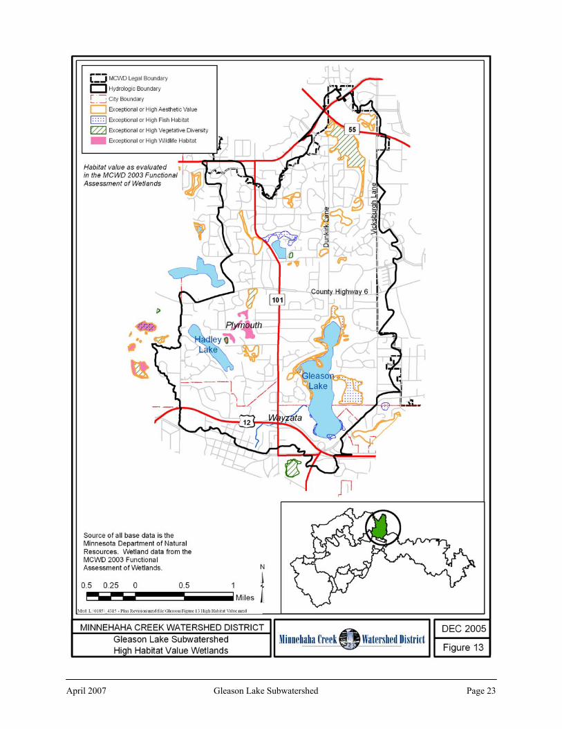
Preserve 33 121.6 25.0 Manage 1 42 132.0 27.2 Manage 2 25 118.8 24.7 Manage 3 72 113.4 23.1 TOTAL 172 485.8 Note: The FAW excluded large lakes and wetlands less than ¼ acre in size; those areas are included in the NWI, so total will not match Tables 6 or 7. Source: MCWD 2003 Functional Assessment of Wetlands. See Figure 12. The Gleason Lake subwatershed has a wide scattering of small wetlands across the subwatershed. Two large wetlands – on the east side of Gleason lake and just south of TH 55 –scored highly on vegetative diversity, fish and wildlife habitat, or aesthetics (see Figure 13). Other high quality wetlands include those riparian to Gleason Lake.
April 2007 Gleason Lake Subwatershed Page 19

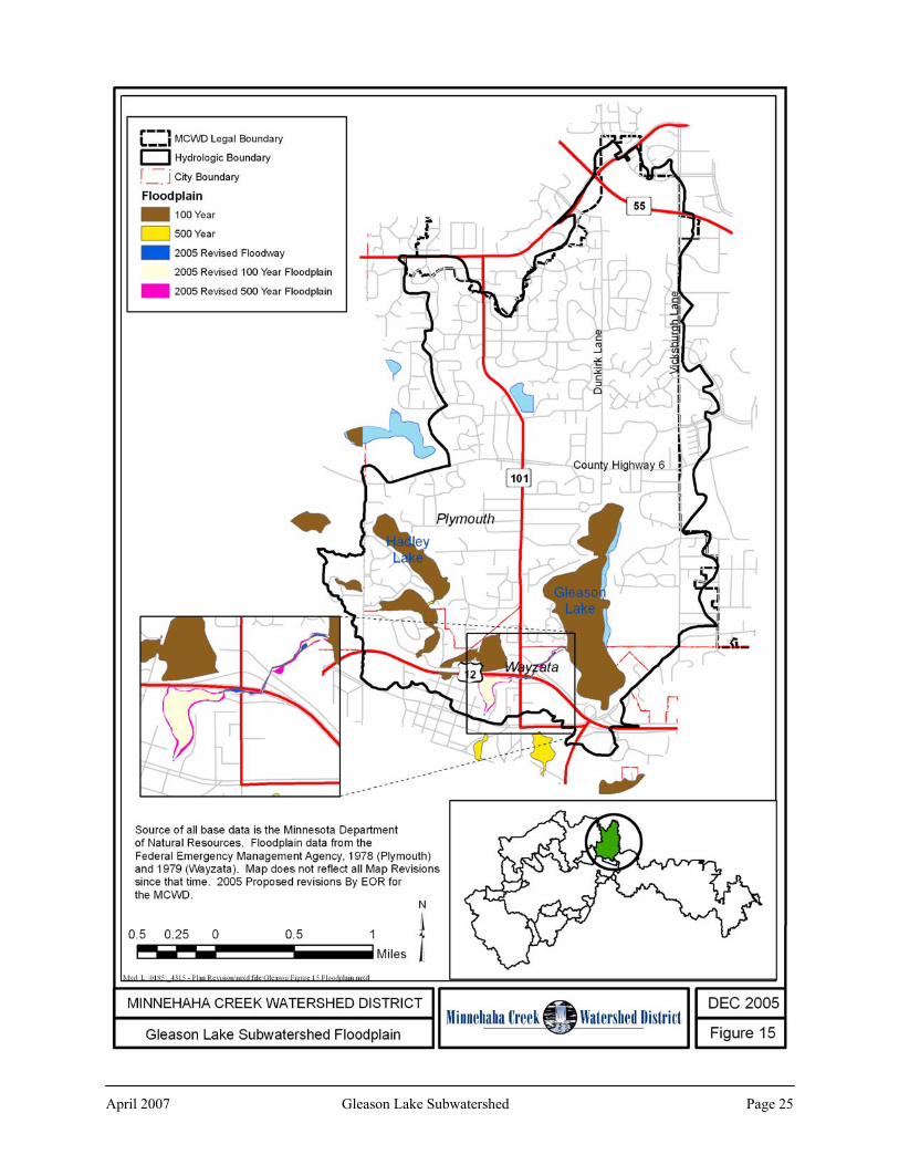
Some of the wetlands were also evaluated for restoration potential. Factors considered were the ease with which the wetland could be restored, the number of landowners within the historic basin, the size of the potential restoration area, the potential for establishing buffer areas or water quality ponding, and the extent and type of hydrologic alteration. Only a few small wetlands of moderate restoration potential are located throughout the subwatershed, and one small wetland with high potential for restoration (see Figure 14). 2.5.5 Floodplain In 2005 the District completed an evaluation of flood elevations on Minnehaha Creek, and four upper watershed streams: Gleason Creek, Long Lake Creek, Painter Creek, and Six Mile Creek. Figure 15 shows the elevations of floodplains modeled by the District and other floodplains in the subwatershed. 2.5.6 Groundwater
The HHPLS identified the infiltration potential of the upland areas within the subwatershed as medium to low with some areas of variability where the soils are organic in nature (see Figure 16). The area to the north and east of Gleason Lake is of high infiltration potential as well as high aquifer sensitivity due to the outwash nature of the underlying soil deposits. The Hennepin County Geologic Atlas classifies most of the upland areas as being of low to moderate sensitivity to pollution, and the areas of outwash as highly sensitive (see Figure 17). Most of the Gleason Lake subwatershed has been designated by the Minnesota Department of Health as a Drinking Water Sensitivity Management Area (DWSMA) and Wellhead Protection Area for City of Plymouth public wells. The MDH has designated much of this area to be of a low risk and vulnerability to contamination of the drinking water supply, with the area of high infiltration capacity and aquifer sensitivity as being moderate to high risk and vulnerability. Figure 18 shows the DWSMA and associated Wellhead Protection Areas.
April 2007 Gleason Lake Subwatershed Page 20

April 2007 Gleason Lake Subwatershed Page 21 April 2007 Gleason Lake Subwatershed Page 21
April 2007 Gleason Lake Subwatershed Page 22 April 2007 Gleason Lake Subwatershed Page 22
April 2007 Gleason Lake Subwatershed Page 23

April 2007 Gleason Lake Subwatershed Page 24
April 2007 Gleason Lake Subwatershed Page 24
April 2007 Gleason Lake Subwatershed Page 25

April 2007 Gleason Lake Subwatershed Page 26

April 2007 Gleason Lake Subwatershed Page 27

April 2007 Gleason Lake Subwatershed Page 28

3.0 Problems and Issues
3.1 Water Quality
1. The water quality in Gleason Lake since 1998 has consistently been scored in the C-D grade range on the District’s annual lake report cards. The mean summer 2004 total phosphorus concentration was 108 μg/L, well in excess of the District’s interim 80 μg/L goal. Based on this monitoring history Gleason Lake’s water quality is not supportive of swimming. The proposed state standard for shallow lakes is 60 μg/L; the long-term goal for Gleason Lake is to in the long term achieve that standard or better. Phosphorus loading reductions would be necessary to achieve either of the desired interim or long-term goal in-lake phosphorus concentrations. Little or no data is available for Hadley, Kreatz, and Snyder Lakes. However, the Regional Team has recommended a goal of 10 percent reduction in TP for these lakes.
2. Development, redevelopment, and reconstruction in the subwatershed will increase nutrient and TSS loads from the watershed as well as increasing the volume of stormwater runoff, potentially further degrading water quality in Dutch Lake and streams and wetlands in the subwatershed.
3. Gleason Creek conveys significant phosphorus and sediment loads downstream, and dissolved oxygen can fall below the state standard during low flows.
4. The Gleason Lake Management plan identified some areas of shoreline erosion on Gleason Lake that could be contributing to reductions in lake water clarity and increased pollutant loading.
3.2 Water Quantity
1. Drainage is conveyed through the subwatershed through County Ditch #15 as well as other channels to Gleason Lake. The HHPLS channel erosion survey on Ditch #15 identified five erosion locations, including two that were of a high level of concern. Gleason Lake outlets through Gleason Creek, and the Upper Watershed Stream Assessment identified five erosion locations on Gleason Creek.
2. The HHPLS identified a number of ponding locations that are predicted to overtop during the 100-year event, as well as others with a minimal amount of freeboard. More detail is available in the HHPLS.
3. Development, redevelopment, and reconstruction in the subwatershed, especially in GLC-4 (see Figure 2) in areas of potential development adjacent to TH 55, may increase volume of stormwater runoff from the subwatershed as well as increasing nutrient and sediment loads.
April 2007 Gleason Lake Subwatershed Page 29

4. The HHPLS identified two locations where for both existing and future conditions higher velocities than desired may result in erosive velocities at outlets or culverts. These include the TH 101 culvert at the outlet of Snyder Lake and at an arch culvert that passes Ditch #15 below CR 6. Erosion control or energy dissipation measures may be required in those locations.
3.3 Wetlands
1. As described in Section 2.5.4, the subwatershed includes Preserve classification wetlands adjacent to Gleason Lake that provide high to exceptional fish habitat and aesthetic values that should be protected.
3.4 Ecological Integrity
1. Few opportunities are available to conserve minimally disturbed landscapes, but there are potential restoration opportunities to improve and increase habitat; native vegetation restoration along the upper watershed channel corridor for streambank stability, erosion control, and habitat connectivity; and urban forest preservation and restoration to increase evapotranspiration and reduce runoff.
2. Wetlands with high ecological value are present and those wetlands and associated upland areas should be conserved to preserve their values and create larger areas of ecological value.
3. The Gleason Lake fishery was last surveyed in 1996 and revealed a panfish fishery that could be improved through a piscavore stocking program.
4. Eurasian water milfoil is present in the lake, as is curlyleaf pondweed.
5. An aquatic plant survey conducted for the Gleason Lake Management Plan revealed a significant vegetative community dominated by coontail.
3.5 Groundwater
1. Many of the major wetlands in the subwatershed were identified in the FAW as combination recharge-discharge wetlands. A number of small recharge wetlands are scattered around the subwatershed. Several discharge wetlands are present in the Hadley Lake subwatershed. As development occurs it will be important to maintain runoff and infiltration rates to help maintain hydrology to these wetlands.
2. Several wetland areas in the Hadley Lake watershed are in highly sensitive aquifer impact areas (see Figure 17).
3. Almost the entire subwatershed is identified as a Wellhead Protection Area for the City of Plymouth (see Figure 18). Stormwater management should be coordinated with wellhead protection plans.
April 2007 Gleason Lake Subwatershed Page 30

3.6 Impacts of Future Growth Land use change impacts downstream water quality by increasing the volume of runoff and the concentration and load of nutrients and sediment transported to receiving waters. Table 9 illustrates how land use change such as the expected conversion of vacant land to other uses could be expected to impact water quality in Gleason Lake. The table also illustrates the impact of a regulatory program managing these impacts. ‘Ultimate Development’ is defined as the conversion of all agricultural lands and one-half of the upland forested area that remains undeveloped in the 2020 local government land use plans. This conversion may take place by 2030 or require significantly more time; but it is assumed that at some point in the future these conversions will occur. More detail regarding this modeling can be found in Technical Appendix A. Table 9 contrasts three nutrient loading reduction scenarios. Scenarios 1 and 2 contrast the required load reductions if there were no regulatory program to the requirements under the existing regulatory program. The HHPLS assumed that there would be no load increase from future development; the third scenario in Table 9 indicates that even with a stringent regulatory program that strictly prohibits any new phosphorus loading, additional reductions would be necessary to achieve the desired phosphorus concentration goal of 80 μg/L. Table 9. Gleason Lake modeled 2020 and ultimate development water quality and the total phosphorus loading reduction necessary to achieve in-lake total phosphorus concentration goals.
2000 2020 Ultimate Development
Scenario 1: No Regulatory Program Predicted in-lake TP (μg/L) 121 121 121 P load decrease needed to achieve 80 μg/L (lbs/year) 614
Scenario 2: Current Regulatory Program Predicted in-lake TP (μg/L) 121 P load decrease needed to achieve 80 μg/L (lbs/year) 599
Scenario 3: Regulatory Program That Prohibits A Net Increase in Loading from New Development (as assumed in HHPLS)
Predicted in-lake TP (μg/L) 120 Additional P load decrease needed to achieve 80 μg/L (lbs/year) 585
April 2007 Gleason Lake Subwatershed Page 31

4.0 Resource Management Goals and Strategies
The following section presents the 17 watershed goals approved by the MCWD, measurable objectives, metrics and the specific goals and actions for the Gleason Lake subwatershed. 4.1 Abstraction/Filtration
MCWD Goal 1: Abstraction/filtration. Promote abstraction and filtration of surface water where feasible for the purposes of improving water quality and increasing groundwater recharge throughout the watershed.
Discussion: Development and the associated creation of new impervious surface increases the volume of stormwater runoff. The new runoff volume can convey more pollutants to receiving waters and may increase erosion and sediment transport, negatively affecting water quality. Development also decreases the amount of stormwater that naturally percolates into the soil to recharge groundwater, thus reducing baseflow in streams, changing hydrology in groundwater-fed wetlands, and decreasing water availability in drinking water aquifers. Most of the Gleason Lake subwatershed is developed, and those hydrologic impacts have already occurred. Abstraction of stormwater (retained on site through infiltration, evapotranspiration, or capture and reuse) reduces the amount of runoff from the site conveying pollutants. The most common type of abstraction, infiltration, reduces runoff, which helps recharge groundwater. Filtration offers an opportunity to use soil to naturally cleanse stormwater prior to discharge. Increasing abstraction and filtration in the subwatershed where opportunities occur is desirable for two primary reasons: 1) to reduce the amount of pollutant loading into the lakes and 2) to protect the hydrology of the wetlands in the subwatershed. Many of those wetlands are key resources with high ecological values that are dependant on groundwater to maintain those functions and values. A key strategy to achieve this goal is the adoption of a volume management standard for new development and redevelopment that requires the abstraction of one inch of rainfall. Much of the subwatershed has moderate to high infiltration potential. Requiring new development and redevelopment to abstract some of the new stormwater generated and encouraging retrofitting to increase infiltration on existing sites would: • Minimize additional pollutant loading that would have been conveyed by that stormwater.
The phosphorus load reduction plan for Gleason Lake assumes that permitted new development and redevelopment will achieve a much higher rate of phosphorus load removal than can be achieved through traditional stormwater management such as detention ponds. Abstraction and infiltration are important tools in achieving the load reductions necessary to
April 2007 Gleason Lake Subwatershed Page 32

achieve water quality goals in those lakes, and to prevent further degradation of the other lakes, streams, and wetlands;
• Reduce runoff volumes and help reduce future downstream erosion in streams and channels or flooding in landlocked basins; and
• Help maintain groundwater levels, preserving wetland hydrology and stream baseflows. Because the Gleason Lake subwatershed is almost entirely developed, there will be few new opportunities to implement abstraction. The primary strategies will be providing for infiltration on infill development and redevelopment, and encouraging retrofits on existing development. Desired Outcomes: Increased infiltration, reduction in pollutant loading and volumes of runoff to supplement other goals. Metrics: Acre-feet of infiltration to meet nutrient loading reductions for water quality and volume reductions for water quantity goals. Gleason Lake Goal 1.1: Increase abstraction and infiltration to reduce runoff volumes carrying pollutant loads and to promote groundwater recharge.
Action A. In consultation with LGUs through an appropriate rulemaking process, amend existing or establish new District rules to increase stormwater requirements through consideration of abstraction of the first one inch of rainfall on new permitted development and redevelopment.
Action B. Develop infiltration strategies appropriate to wellhead protection areas and areas of groundwater sensitivity.
Action C. Construct regional infiltration basins on a cooperative basis with LGUs where additional infiltration is desired.
Action D. Promote reforestation and revegetation with native plants to increase infiltration.
Action E. Provide technical assistance to LGUs and developers to foster low impact development and redevelopment that minimizes new impervious surface and provides for increased infiltration. i. Develop and distribute model ordinances and design standards
that incorporate low impact design principles. ii. Sponsor educational opportunities for LGU staff, developers,
elected and appointed officials and other interested parties to provide practical information and opportunities for sharing experiences.
iii. Provide education and training opportunities, technical and planning assistance for property owners and LGUs on methods to reduce runoff from and increase infiltration on their property by incorporating BMPs into landscaping, infrastructure maintenance, and reconstruction.
April 2007 Gleason Lake Subwatershed Page 33

iv. Develop a small grant program to provide financial assistance to property owners desiring to retrofit their property with BMPs to increase infiltration.
4.2 Ecological Integrity
MCWD Goal 2: Ecological Integrity. Promote activities that maintain, support and enhance floral, faunal quantity and ecological integrity of upland and aquatic resources throughout the watershed.
Discussion: Gleason and Hadley Lakes and associated uplands and wetlands are the primary ecological resources in the subwatershed, although there are some other wetlands with high values present. Figure 19 details Key Conservation Areas for conservation of ecological integrity within this subwatershed. Within these conservation areas wherever possible the District would promote the preservation or establishment of native vegetation to increase or maintain infiltration rates; decrease or maintain runoff rates and pollutant conveyance to water resources; and minimize erosion of shorelines and streambanks. Sustaining or improving water quality and ecological integrity is necessary to meet the District goals in this plan as well as to meet state and federal nondegradation, water quality and biological integrity requirements and to prevent the need for future TMDLs. The Gleason Lake Creek subwatershed includes several wetlands with exceptional or high fish or wildlife habitat value as well as wetlands with exceptional or high vegetative diversity. The Key Conservation Areas identified in this plan include those wetlands as well as associated upland areas of ecological value such as oak and maple-basswood forest. Conservation of those associated upland areas not only provides additional habitat type, but also helps preserve local runoff and infiltration rates. The primary strategies for improving aquatic communities are the acquisition of new data such as vegetation surveys and management plans, and improvement of water quality. There are a few wetlands in the subwatershed with exceptional or high vegetative diversity. These would be inspected at least annually for invasive vegetative species. Desired Outcomes: Functional and healthy ecological corridors and waters throughout the subwatershed. Metrics:
• Acres of land conserved in Key Conservation AreasStream Visual Assessment Protocol (SVAP) in Gleason Lake Creek
• Acres of restored/created wetland within Key Conservation Areas Gleason Lake Goal 2.1: Maintain and improve overall ecological integrity within the
subwatershed.
April 2007 Gleason Lake Subwatershed Page 34

Action A. Protect existing fish and wildlife habitat and promote the restoration of habitat areas and corridors by the conservation and restoration of key ecological areas (see Figure 19). i. Require LGUs to recognize Key Conservation Areas in their
natural resources and land use planning and to identify in their Local Water Management plans how they intend to conserve their ecological values.
ii. Provide education and training opportunities, technical and planning assistance, and financial incentives to LGUs to actively conserve key ecological areas.
Action B. Work cooperatively with other agencies and organizations to improve upon existing conservation corridors and where practical, develop new conservation corridors connecting high-value resources within the subwatershed.
Action C. Identify keystone, umbrella, and indicator species to serve as indicators of ecological integrity, evaluate existing habitat within the subwatershed, and develop strategies for the conservation of that habitat.
Action D. Provide regulatory incentives for the conservation of undisturbed native vegetation as sites develop.
Action E. Require MCWD review of preliminary plats and vegetation surveys so the District may comment on proposals and how they relate to District ecological integrity goals.
Gleason Lake Goal 2.2: Maintain conditions suitable for healthy and varied fish community
within Gleason Lake.
Action A. Work cooperatively with the DNR and the Gleason Lake Association in Gleason Lake fishery management efforts, and request that fish surveys be conducted periodically.
Action B. Achieve Gleason Lake water quality and clarity goals to maintain or improve habitat conditions.
Action C. Manage aquatic vegetation in accordance with a vegetation management plan that takes into account fishery habitat requirements.
Gleason Lake Goal 2.3: Maintain a healthy aquatic vegetation community.
Action A. Update the survey of aquatic vegetation in Gleason Lake and continue updating it every five years.
Action B. Develop and implement an aquatic vegetation management plan for Gleason Lake that evaluates and implements options for the management of curly leaf pondweed to improve water quality and habitat as well as maintenance of a desirable aquatic vegetation community.
Action C. Recruit and train volunteers to monitor aquatic vegetation in Gleason Lake on an ongoing basis.
April 2007 Gleason Lake Subwatershed Page 35

Action D. Develop and implement a plan to monitor wetlands with exceptional or high vegetative diversity for presence of exotic vegetative species.
Gleason Lake Goal 2.4: Maintain conditions suitable for a healthy and varied biologic
community in Gleason Creek.
Action A. Reduce phosphorus and sediment in Gleason Creek and minimize periods when dissolved oxygen falls below the level necessary to sustain aquatic life. i. Implement the water quality improvement actions of this Plan
to reduce load discharged into the creek from Gleason and Hadley Lakes and washed off from the watershed.
ii. Work cooperatively with the City of Wayzata to repair eroded streambanks identified in the Stream Assessment and through other inspections.
iii. Implement the water quantity improvement actions of this Plan to limit periods of erosive velocities in the creek.
Action B. Increase macroinvertebrate and fish habitat in Gleason Creek. i. As opportunities arise identify potential locations and install
habitat features such as improved substrate, cobble and boulders, vegetated streambanks, root wads, and large woody debris.
Action C. Monitor the macroinvertebrate community every 2-3 years. Action D. Woody debris that falls in Gleason Lake Creek or other streams shall
only be removed if it causes an obstruction to flow such that streambanks are destabilized or eroded or the creek is caused to overtop its banks. Such debris shall be removed by the District or by cooperative arrangement with the LGU at the owner’s expense.
4.3 Water Quality
MCWD Goal 3. Water Quality. Preserve, maintain and improve aesthetic, physical, chemical and biological composition of surface waters and groundwater within the District.
Discussion: The HHPLS used an extensive public input process to establish water quality goals for the primary receiving waters in the District, focusing primarily on identifying target total phosphorus concentrations. That work was refined by the Gleason Lake Management Plan. This plan identifies those plus additional goals related to water quality. This plan sets forth a set of actions the District will undertake to reduce pollutant loading in the subwatershed and achieve water quality goals. The achievement of these water quality goals is not only necessary to meet state and federal water quality requirements and to prevent future TMDLs, but also to meet this plan’s ecological integrity goals. Desired Outcomes: Achievement of in-lake nutrient concentration goals through achievement of nutrient loading reductions.
April 2007 Gleason Lake Subwatershed Page 36

Metrics: • In-lake nutrient concentrations/Trophic State Index Scores (TSI) for Gleason Lake • Nutrient loading goals (lbs) for Gleason Lake
Gleason Lake Goal 3.1: Achieve an interim in-lake total phosphorus concentration goal of 80
μg/L in Gleason Lake.
Action A. Develop a vegetation management plan that evaluates the feasibility of controlling curly leaf pondweed and quantifies the potential internal phosphorus load reduction that could be achieved through biological, chemical or mechanical manipulation, and sets forth an implementation plan.
Action B. In cooperation with the City of Plymouth and the Gleason Lake Association, implement improvement projects identified in the Gleason Lake Management Plan: improvements to ponds 2, 3, 6, 8, and Cimarron Ponds; the Wayzata Central Middle school treatment project; and stabilization of bank erosion site E3 (see Figure 20).
Action C. Construct a wet detention pond at the inlet of Gleason Lake to provide treatment for upstream drainage.
Action D. In cooperation with the City of Plymouth, construct a wet detention pond on Ditch #15 upstream of CR 6 to provide treatment for upstream drainage.
Action E. Require LGUs to reduce phosphorus loading upstream of Gleason Lake by a minimum of 115 pounds per year within 10 years. i. Provide education and training opportunities, technical and
planning assistance for property owners and LGUs on methods to reduce phosphorus and sediment loading by incorporating BMPs into landscaping, agriculture, infrastructure maintenance, and reconstruction.
Action F. Provide assistance to LGUs and developers to foster low impact development and redevelopment that minimizes new phosphorus and sediment loading. i. Develop and distribute model ordinances and design standards
that incorporate low impact design principles. ii. Sponsor educational opportunities for LGU staff, developers,
elected and appointed officials and other interested parties to provide practical information and opportunities for sharing experiences.
Action G. Promote the general application of BMPs across the subwatershed. i. Consider developing a small grant program to provide financial
assistance to property owners desiring to retrofit their property with BMPs to reduce phosphorus and sediment loading.
Action H. Continue regular water quality monitoring in Gleason Lake to assess progress toward achieving the in-lake phosphorus goal.
April 2007 Gleason Lake Subwatershed Page 37

Gleason Lake Goal 3.2: Prevent degradation of existing water quality in Hadley, Kreatz, and
Snyder Lakes.
Action A. Obtain baseline water quality data for Hadley, Kreatz, and Snyder Lakes and update every three to five years.
Action B. Develop a water quality index which encompasses the District’s broader definition of water quality.
Action C. Achieve a 10 percent reduction in the in-lake total phosphorus concentration in Hadley, Kreatz, and Snyder Lakes through the general application of BMPs across the subwatershed. i. Require LGUs to reduce phosphorus loading upstream of
Hadley Lake by a minimum of 26 pounds per year within 10 years.
Gleason Lake Goal 3.3: Achieve and maintain other state shallow lake water quality standards
in Gleason Lake including >1.0 m Secchi clarity and 20 ug/L chl-a.
Action A. Achieve and maintain in-lake total phosphorus goals. Action B. Manage aquatic vegetation in accordance with a vegetation
management plan that takes into account water clarity goals. Gleason Lake Goal 3.3: Minimize pollutant loading contribution to Wayzata Bay from Gleason
Lake and Gleason Creek.
Action A. Achieve Gleason Lake in-lake total phosphorus concentration goal. Action B. Require LGUs to reduce phosphorus loading downstream of Gleason
and Hadley Lakes by a minimum of 32 pounds per year within 10 years.
Action C. Inspect erosion-prone areas Gleason Creek at least annually to identify new erosion areas,
Action D. Work cooperatively with the City of Wayzata to repair identified erosion in Gleason Creek and to prevent future erosion and sediment transport.
Action E. Continue to monitor water quality in Gleason Creek. 4.4 Public Health
MCWD Goal 4. Public Health. Minimize the risks of threats to public health through the development of programs, plans and policies that improve the quality of surface and groundwater resources.
April 2007 Gleason Lake Subwatershed Page 38

Discussion: There are several potential threats to public health in the Gleason Lake subwatershed. Sewage overflows from sanitary sewer breaks or improperly functioning infrastructure could result in overflows discharged to downstream water resources. An additional potential source of pathogens is waterfowl, which are attracted to open water with easy routes from the water to vegetation on shore. Goose management on Gleason Lake is an issue. The District’s role in minimizing the threats to public health in the Gleason Lake subwatershed is mainly to provide targeted information to landowners and LGUs. Desired Outcomes: Minimization of threats to public health from contact with contaminated surface waters. Metrics: Reported cases of illness transmission via surface water contact.
Gleason Lake Goal 4.1: Minimize risks to human health and water quality from land use
activities.
Action A. Work cooperatively with the state, Hennepin County and LGUs to identify and provide BMP information and technical assistance to individual sewage treatment system owners.
Gleason Lake Goal 4.2: Maintain a vegetated shoreline on Gleason Lake where practical and effective to reduce overpopulation of the lake with waterfowl.
Action A. Update the Gleason Lake shoreline vegetation survey to identify current shoreline status and to identify locations where restoration may be desirable and feasible.
Action B. Promote native vegetation over structural shoreline stabilization where appropriate in District policies, regulations, and programs.
Action C. Work cooperatively with LGUs and property owners to restore native shoreline vegetation where appropriate. i. Provide education and training opportunities, technical and
planning assistance, and demonstration project funding to LGUs to assist them in restoring shorelines and buffers on public property such as parks and open spaces, taking into consideration the balance between recreational use and ecosystem needs.
ii. Develop and distribute written material to shoreline property owners explaining the benefits of shoreline restoration and buffer creation to waterfowl control and providing design, plant selection, installation, and maintenance advice.
Gleason Lake Goal 4.3: Require LGUs and other agencies to manage public sanitary sewer
infrastructure to minimize sewage overflows and to minimize impacts from those overflows on District water resources.
April 2007 Gleason Lake Subwatershed Page 39

4.5 Water Quantity
MCWD Goal 5. Water Quantity. Maintain or reduce existing flows from drainage within the watershed to decrease the negative effects of stormwater runoff and bounce from existing and proposed development as well as provide low flow augmentation to surface waters.
Discussion: Development and the associated creation of new impervious surface increases the volume of stormwater runoff from the landscape, changes the rates and times to peak runoff flow, and decreases the amount of stormwater that naturally percolates into the soil to recharge groundwater. The District’s long term goal in the Gleason Lake subwatershed is to achieve no increase in the volume of stormwater discharged from the subwatershed into Wayzata Bay. Implementation strategies will include minimizing new runoff volumes from development and encouraging infiltration and groundwater recharge to maintain baseflow in Gleason Creek and adequate hydrology to groundwater-fed wetlands. A key strategy to achieve this goal is the adoption of a volume management standard for new development and redevelopment that requires the abstraction (removal from runoff through infiltration, capture and reuse, evapotranspiration, etc.) of one inch of rainfall. Approximately 70 percent of annual runoff volume in Minnesota results from precipitation events of 1” or less (MPCA, 2000). Requiring new development and redevelopment to abstract (retain on site through infiltration, evapotranspiration, or capture and reuse) runoff from small rain events would significantly reduce new volumes of runoff flowing downstream and help reduce future erosion in streams and channels; minimize new pollutant loading that would have been conveyed by that stormwater; and help maintain groundwater levels, preserving wetlands. The additional new volume could be mitigated through construction of regional infiltration basins, restoring drained wetlands, reforestation and revegetation, or other means. Table 10. Modeled annual volume of runoff in the Gleason Lake subwatershed, and estimated reductions resulting from application of a proposed 1” abstraction rule for new development and redevelopment (acre-feet). 2000 modeled annual subwatershed runoff volume 1,352 2020 modeled annual subwatershed runoff volume 1,398 Ultimate Development modeled annual subwatershed runoff volume 1,403 Increase between 2000 and Ultimate development 51 Estimated volume abstracted by 1” rule 36 New volume to be abstracted through other means such as capital projects, wetland restorations, reforestation and revegetation, etc. 15
Desired Outcomes: Management of new annual water volume discharged from the subwatershed. Metrics: Acre-feet volume abstraction. Gleason Lake Goal 5.1: Reduce volume of stormwater runoff from new development and
redevelopment and maintain or reduce existing water volumes discharged from the subwatershed into Wayzata Bay.
April 2007 Gleason Lake Subwatershed Page 40

Action A. Amend existing or establish new District rules requiring abstraction of
the first one inch of rainfall on new permitted development and redevelopment.
Action B. Track volumes abstracted and new volumes created resulting from permitted development.
Action C. Provide assistance to LGUs and developers to foster low impact development and redevelopment that minimizes new stormwater volumes. i. Develop and distribute model ordinances and design standards
that incorporate low impact design principles. ii. Sponsor educational opportunities for LGU staff, developers,
elected and appointed officials and other interested parties to provide practical information and opportunities for sharing experiences.
Action D. Encourage the development and maintenance of depressional storage within the subwatershed.
Gleason Lake Goal 5.2: Manage water volumes to Ditch #15 and Gleason Creek to prevent
further erosion.
Action A. Inspect erosion-prone areas of Gleason Creek and Ditch #15 at least annually to assess its condition.
Action B. Work cooperatively with the Cities of Plymouth and Wayzata to reduce volumes as necessary.
Action C. Continue to monitor flows in Gleason Creek. Gleason Lake Goal 5.3: Require public stormwater conveyance and control structures in the
watershed be sized and maintained properly to convey current and ultimate stormwater flows to minimize flooding and erosion potential.
Action A. Require LGUs to provide to the District a copy of their annual NPDES
report.
4.6 Shorelines and Streambanks
MCWD Goal 6. Shorelines and Streambanks. Preserve the natural appearance of shoreline areas and minimize degradation of surface water quality which can result from dredging operations.
Discussion: Eroding shorelines and streambanks contribute to the degradation of water quality. Native vegetation can effectively stabilize these areas, filter runoff for sediment and other pollutants, and provide habitat. The Gleason Lake Management Plan identified lake shoreline areas where erosion was occurring. Restoration of shoreline and streambanks on Gleason Lake, Gleason Creek and Ditch #15, and wetlands within the subwatershed is a key strategy for meeting this plan’s goals.
April 2007 Gleason Lake Subwatershed Page 41

The key areas identified in this plan for conservation activities include the conservation of buffer zones adjacent to streams and channels. In some cases these buffer zones are riparian or flow-through wetlands, and those wetlands have been identified as key conservation areas. Where streams and channels flow through upland areas, conservation of native vegetation within these zones would provide habitat for both aquatic and terrestrial wildlife; help increase or maintain infiltration rates; decrease or maintain runoff rates and pollutant conveyance to water resources; and help minimize erosion. Restoration of lakeshore would have the same benefits. Sustaining or improving water quality and ecological integrity is necessary to meet District goals as well as to meet state and federal nondegradation, water quality and biological integrity requirements and to prevent the need for future TMDLs. Desired Outcomes: Stable streambanks and shorelines to supplement other goals. Metrics: Stream Visual Assessment Protocol (SVAP) score in Gleason Lake Creek. Gleason Lake Goal 6.1: Promote shoreline and streambank restoration and shoreline buffer
creation as methods to help meet pollutant loading reduction and ecological integrity goals.
Action A. Update the shoreline vegetation survey to identify current shoreline
status and to identify locations where restoration may be desirable and feasible.
Action B. Restore degraded streambanks on Gleason Creek to achieve a Stream Visual Assessment Protocol mean score above 5.0 and on other streams to stabilize streambanks; reduce pollutant loading, erosion and sediment transport; and increase habitat. i. Periodically update the Gleason Creek stream assessment to
assess current stream condition and ecological integrity.
Action C. Promote native vegetation over structural shoreline stabilization in District policies, regulations, and programs. i. Provide education and training opportunities, technical and
planning assistance, and demonstration project funding to LGUs to assist them in restoring shorelines and buffers on public property such as parks and open spaces.
ii. Develop and distribute written material to shoreline property owners explaining the benefits of shoreline restoration and buffer creation to the reduction of pollutant loads and creation of shoreline habitat and providing design, plant selection, installation, and maintenance advice.
iii. Develop a small grant program to provide financial assistance to property owners desiring to restore their shoreline or plant a buffer.
April 2007 Gleason Lake Subwatershed Page 42

4.7 Navigation
MCWD Goal 7. Navigation. Maintain the hydraulic capacity of and minimize obstruction to navigation without compromising wildlife habitat in watercourses and preserve water quality and navigation appearance in shoreland areas.
Discussion: The District recognizes the riparian rights of property owners to have and maintain access to public waters. The District will not participate in the removal of nuisance aquatic vegetation solely for the purpose of improving navigation, but may consider macrophyte control where excessive growth contributes to poor water quality. Desired Outcomes: Minimization of impacts on water resources from dredging. Metrics: Compliance with the dredging policy. Gleason Lake Goal 7.1: Manage dredging activities so as to preserve the natural appearance of
shoreline areas; recreational, wildlife and fisheries resources of surface waters; surface water quality and ecological integrity of the riparian environment.
Action A. Regulate dredging activities in a manner consistent with local policy
and Minnesota Rules Chapter 6115.0200 4.8 Best Management Practices
MCWD Goal 8. Best Management Practices. Improve water quality by promoting best management practices (BMPs), requiring their adoption in local plans and their implementation on development sites.
Discussion: This plan and District regulations stipulate the use of Best Management Practices (BMPs) to reduce stormwater volumes and pollutant loadings, but do not prescribe which practices should be used. This allows the LGU and developers the flexibility to implement those that are most appropriate for local conditions and opportunities. A key strategy for plan implementation is providing early consultation with and technical assistance to and education of stakeholders including city staff, residents, and developers to increase knowledge and acceptance of various BMPs and to promote their adoption. Desired Outcomes: Implementation of Best Management Practices on private and public property to supplement other goals. Metrics: Compliance with the early consultation requirement.
April 2007 Gleason Lake Subwatershed Page 43

Gleason Lake Goal 8.1: Promote best management practices as methods to help meet pollutant loading and volume reduction goals established in this subwatershed plan.
Action B. Require LGUs to identify in their local water management plans how
they plan to meet specific phosphorus loading minimum reduction goals and stormwater volumes from developed uses through the implementation of BMPs in the subwatershed. i. Provide education and training opportunities, technical and
planning assistance for LGUs on methods to reduce phosphorus and sediment loading by incorporating BMPs into landscaping, infrastructure maintenance, and reconstruction.
Action B. To promote BMPs and encourage early consultation by developers, amend District rules to incorporate a requirement for stormwater management plan approval prior to submittal of a preliminary plat.
Action C. Develop and distribute model ordinances and design standards that illustrate the proper application of various BMPs.
4.9 Education and Communications
MCWD Goal 9. Education and Communications. Enhance public participation and knowledge regarding District activities and provide informational and educational material to municipalities, community groups, businesses, schools, developers, contractors and individuals.
Discussion: The District conducts an active strategic education and communication program watershed-wide to provide general information and to various stakeholder groups in accordance with its five-year strategic education and outreach plan. Targeted information will be necessary in the Gleason Lake subwatershed to educate these stakeholders as to the District’s specific goals for this subwatershed, the actions the District plans to take, and their role in conserving water resources in the subwatershed. The specific targeted messages will emphasize the unique nature of shallow lakes such as Gleason Lake and how water quality expectations and management strategies may be different than those of deep lakes. Desired Outcomes: Stewardship over water resources by residents of the subwatershed to assist District activities and supplement other goals. Metrics: Telephone survey. Gleason Lake Goal 9.1: Provide focused education and outreach opportunities within this
subwatershed to supplement the general education and outreach program and assist in the achievement of these subwatershed goals.
Action A. Develop and distribute targeted written material to stakeholder groups
(e.g., residents, shoreline property owners, developers) explaining the
April 2007 Gleason Lake Subwatershed Page 44

unique nature of shallow lakes and providing strategies that each stakeholder group can employ to assist in meeting this goal.
Action B. Sponsor educational opportunities for LGU staff, developers, elected and appointed officials and other interested parties to provide practical information and opportunities for sharing experiences.
Action C. Prepare and distribute timely news releases to coincide with education efforts to inform the public of BMPs and other District actions that affect them directly.
Gleason Lake Goal 9.2: Provide participation and outreach activities to increase awareness of
water and other natural resources within the subwatershed.
Action A. Work cooperatively with the Gleason Lake Association on issues identified in this Plan.
Action B. Recruit and train volunteers to monitor aquatic vegetation in Gleason Lake on an ongoing basis.
Gleason Lake Goal 9.3: Work cooperatively with other agencies and groups to coordinate
education and outreach efforts to avoid duplication of efforts and maximize resources.
4.10 Ditches
MCWD Goal 10. Public Ditches. Maintain public ditch systems within the District as required under Statutory jurisdiction.
Discussion: Neither of the public ditches within this subwatershed perform the function for which they were originally established – to drain lands for the promotion of agriculture. Both ditches are now part of their respective cities’ local stormwater conveyance systems. Because those ditches are of localized rather than watershed-wide benefit, the Board will pursue turning jurisdiction of these ditches over to the local community. Until that time, the District will manage these ditches to the same standard as other streams. Desired Outcomes: Manage public ditches to maintain drainage and preserve natural features.
Metrics: Stream Visual Assessment Protocol (SVAP) score in ditch portion of Gleason Lake Creek. Gleason Lake Goal 10.1: Turn over to local communities jurisdiction over public ditches that no
longer perform their original function and that serve mainly as local stormwater conveyances.
April 2007 Gleason Lake Subwatershed Page 45

Action A. If the cities are willing, turn back County Ditch #15 and County Ditch #32 (see Figure 2) to the Cities of Plymouth and Wayzata, respectively.
Action B. Until such time as the proposed jurisdictional turnbacks are completed, manage the ditches in accordance with statutory rights and responsibilities, conducting annual inspections and making improvements as required.
4.11 Wetlands
MCWD Goal 11. Wetlands. Preserve, create and restore wetland resources and maximize the benefits and functionality of wetlands to the watershed.
Discussion: The Functional Assessment of Wetlands evaluated 485.8 acres of wetlands in the Gleason Lake Creek subwatershed, of which 121.6 acres were in the Preserve classification (see Table 8 in Section 2.5.4 and Figure 12). There are several wetlands of exceptional and high quality functions and values within this subwatershed. Their conservation is integral to achieving ecological integrity goals, as well as water quality, stormwater management, and floodplain management goals. A key strategy of this plan is regulation of wetland impacts in accordance with a management classification based on the functions and values findings of the Functional Assessment of Wetlands. Wetlands are assigned to a classification – either Preserve or Manage 1, 2, or 3 – and allowable impacts would be based on that classification. The wetlands with the highest values – those in the Preserve classification – would be allowed minimal impacts. The Manage classifications would be allowed some impacts, such as accepting new stormwater discharges, depending on classification. This strategy would preserve existing high values such as habitat, vegetative diversity, and sensitivity, while also recognizing that wetlands play an important part in managing stormwater. Wetlands provide essential storm and flood water storage. Wetlands of exceptional or high vegetative diversity or fish or wildlife habitat value have been designated key conservation areas (see Figure 19), as have wetlands that are riparian to streams or channels, have high restoration potential, or that provide key floodplain storage. Except for those in the Preserve classification, which would be managed to an even higher standard, these conservation wetlands would be managed as if they were Manage 1 classification wetlands, with limitations on the amount of new runoff that can be directed to them, and a requirement to pretreat any new discharges to them. An important part of achieving the goal of no net loss of wetland size, quality, and type will be tracking wetland impacts to assist in identifying future restoration or wetland creation needs. Equally important to the regulation of wetlands is the restoration of degraded wetlands within the subwatershed. Figure 14 identifies wetlands based on restoration potential. Only a few small wetlands were identified in the FAW as having moderate to high restoration potential. Restoring wetlands increases specific functions and values of the resource within the watershed ranging
April 2007 Gleason Lake Subwatershed Page 46

from management of flows to water quality improvement to enhancement of the overall ecosystem, particularly within identified corridors. Desired Outcomes: Maintain existing quantity and quality of wetlands throughout subwatershed; improve wetland and surface water quality within Key Conservation Areas. Metrics:
• Wetland quantity (acres) • Wetland quality (acres/management classification) • Acres of restored/created wetland within Key Conservation Areas
Gleason Lake Goal 11.1: Maintain existing acreage of wetlands in the subwatershed and achieve
no net loss in their size, quality, type, and biological diversity.
Action A. Regulate wetland impacts commensurate with the quality of the wetland as determined by the Management Classifications identified in the Functional Assessment of Wetlands (FAW).
Action B. In consultation with LGUs through an appropriate rulemaking process, amend existing or establish new District rules requiring submittal of a functions and values assessment for all proposed wetland impacts requiring a permit; mitigation of all fill in Preserve category wetlands; and specifying by management classification stormwater discharge pretreatment, buffer, hydroperiod, and other wetland standards.
Action C. Require that wetland losses be mitigated within the lake subwatershed in which they occur, either Gleason or Hadley Lake subwatershed.
Action D. Track wetland losses resulting from permitted fill. Action E. Restore degraded wetlands in Key Conservation Areas to improve
vegetative diversity and ecological integrity, with priority given to wetlands where restoration could improve management classification to at least a Manage 1. Restore other wetlands as opportunities arise.
Action F. Restore vegetative diversity and ecological integrity of all wetlands in which the District acquires an interest.
Action G. Update the MCWD Functional Assessment of Wetlands to maintain a current inventory of wetland location and size, as well as function and value.
Gleason Lake Goal 11.2: Increase the quantity, quality, and biological diversity of Gleason Lake
subwatershed wetlands through the restoration of impacted wetlands or creation of new wetlands.
Action A. Restore other hydrologically impacted wetlands in Key Conservation
Areas determined in the FAW to be “restorable,” where restoration could improve vegetative diversity and ecological integrity.
April 2007 Gleason Lake Subwatershed Page 47
4.12 Groundwater
Watershed Goal 12. Groundwater. Protect and maintain existing groundwater flow, promote groundwater recharge and improve groundwater quality and aquifer protection.
Discussion: Maintenance of groundwater recharge is important in the Gleason Lake subwatershed to maintain hydrology to the groundwater-fed discharge or combination wetlands as well as to recharge aquifers that supply public and private water wells. Development, with the associated creation of new impervious surface, increases the volume of stormwater runoff and reduces the amount of stormwater that naturally percolates into the soil to recharge groundwater. Increased infiltration in the Gleason Lake subwatershed is desirable for two primary reasons: to reduce the amount of pollutant loading into Gleason Lake, and to protect the hydrology of the discharge (groundwater-fed) wetlands in the subwatershed. Many of those wetlands are key resources with high ecological values that are dependant on groundwater to maintain those functions and values. Much of the subwatershed has moderate to high infiltration potential. Requiring new development and redevelopment to infiltrate some of the new stormwater generated would reduce new volumes downstream and help reduce future erosion in streams and channels; minimize new pollutant loading that would have been conveyed by that stormwater; and help maintain groundwater levels, preserving wetlands. Most of the subwatershed is either sensitive to aquifer impacts or is a drinking water wellhead protection area, where care should be taken when infiltrating stormwater. Proper design of infiltration practices is necessary to avoid groundwater contamination. Other land use practices such as the use of private water wells or individual sewage treatment systems should be monitored to prevent contamination of groundwater resources. Groundwater management in the Gleason Lake subwatershed will focus on increasing the amount of infiltration in the subwatershed, and minimizing opportunity for groundwater contamination from land use practices. Desired Outcomes: Maintain function of existing groundwater flow, assist in the protection of drinking water supply, no degradation in surficial groundwater quantity or quality. Metrics:
• Acre-feet volume abstraction • Surficial groundwater levels and parameters
Gleason Lake Goal 12.1: Protect and maintain groundwater recharge and groundwater quality.
Action A. Amend existing or establish new District rules requiring abstraction of the first one inch of rainfall on new permitted development and redevelopment.
Action B. Establish new District rule requiring an additional level of analysis and review of permitted development and redevelopment where there is a
April 2007 Gleason Lake Subwatershed Page 48

potential to adversely impact groundwater connected to a surface water feature.
Action C. Require pretreatment of stormwater discharged to wetlands or infiltration areas in the in the areas of high aquifer sensitivity.
Action D. Coordinate stormwater and groundwater management within identified drinking water management areas and wellhead protection areas with city and private wellhead protection plans.
Action E. Develop infiltration strategies appropriate to wellhead protection areas and areas of groundwater sensitivity.
Action F. Work cooperatively with Hennepin County, the Minnesota Department of Health, and other agencies charged with managing individual sewage treatment systems and private and public groundwater wells to assess the potential impacts of surface water management practices on groundwater quality.
Action G. Provide assistance to LGUs and developers to foster low impact development and redevelopment that minimizes new impervious surface and provides for increased infiltration. i. Develop and distribute model ordinances and design standards
that incorporate low impact design principles. ii. Sponsor regular events such as workshops, seminars, and
brown bags for LGU staff, developers, and other interested parties to provide practical information and opportunities for sharing experiences.
Action H. Identify a network of surficial aquifer monitoring wells across the entire Minnehaha Creek watershed, monitor groundwater levels and groundwater quality, and if change is detected identify strategies for addressing that change.
Gleason Lake Goal 12.2: Protect and maintain groundwater flow.
Action A. Identify base level flow in Gleason Creek, monitor for trends, and if change is suspected identify strategies for addressing that change.
4.13 Floodplains
Watershed Goal 13. Floodplains. Reduce the severity and frequency of flooding and high water by preserving and increasing the existing water storage capacity below 100-year flood elevations on all waterbodies within MCWD.
Discussion: The primary strategy in the management of stormwater and prevention of flooding in the Gleason Lake subwatershed is the preservation of the stormwater storage. Key areas identified in this plan for conservation include wetlands that provide floodplain storage and areas that provide channel and stream floodplain and riparian zones.
April 2007 Gleason Lake Subwatershed Page 49

Desired Outcomes: No net loss of floodplain storage. Metrics: Acres net floodplain fill.
Gleason Lake Goal 13.1: Preserve the existing water storage capacity below the 100-year event
elevation.
Action A. Minimize development below the 100-year event elevation. Action B. No net loss of the large wetland complexes that provide substantial
upstream stormwater storage within this subwatershed. Action C. Encourage the development and maintenance of depressional storage
within the subwatershed. i. Promote the acceptability of minor flooding within the
floodplain.
Gleason Lake Goal 13.2: Utilize District hydrologic and hydraulic data to identify potential public infrastructure high water impacts
Action A. The HHPLS noted that the 100-year water level was expected to overtop a number public streets and private driveways. Local plans should identify these observed or potential locations and assess whether the risk of occasional flooding is acceptable or should be addressed. Assist LGUS in determining specific impacts and potential improvements.
4.14 Recreation
Watershed Goal 14. Recreation. Promote the recreational use, where appropriate, of surface waters within MCWD by providing recreation opportunities for citizens by promoting the use and enjoyment of water resources with the intent of increasing the livability and quality of life within the watershed.
Discussion: Gleason Lake is the primary recreational water resource in this subwatershed, although Hadley, Kreatz, and Snyder Lakes and other streams and wetlands provide aesthetic enjoyment, wildlife viewing, and other recreational values. District and local efforts to improve ecological integrity and conserve corridors will enhance those aesthetic and recreational values across the subwatershed. The District’s primary strategies in promoting and supporting recreational use of Gleason Lake is improving water quality and managing aquatic vegetation. Desired Outcomes: Manage surfaces waters to achieve water quality goals so designated use is maintained and unimpaired. Metrics:
• In-lake nutrient concentrations/Trophic State Index Scores (TSI) for Gleason Lake • Clarity by satellite-estimated Secchi depth for Hadley, Kreatz, and Snyder Lakes
April 2007 Gleason Lake Subwatershed Page 50

• Nutrient loading goals for Gleason Lake Gleason Lake Goal 14.1: Support Gleason Lake recreational use by achieving the District’s
interim goal of 80 μg/L summer mean total phosphorus through the implementation of the programs and projects identified in this plan to reduce phosphorus loads and improving Gleason Lake water quality.
Gleason Lake Goal 14.2: Support the Gleason Lake fishery through the implementation of the
programs and projects identified in this plan to maintain ecological integrity and promote shoreline restoration.
4.15 Erosion Control
Watershed Goal 15. Erosion Control. Control temporary sources of sediment resulting from land disturbance and identify, minimize and correct the effects of sedimentation from erosion-prone and sediment source areas.
Discussion: Erosion within the subwatershed can result in sediment being transported to lakes, wetlands, and streams, where it can degrade water quality and habitat. Sediment accumulating in channels, culverts, and other facilities can reduce their ability to convey stormwater, while erosion can undermine their stability. The key areas identified in this plan for conservation activities include buffer zones adjacent to streams and channels. In some cases these buffer zones are riparian or flow-through wetlands, and those wetlands have been identified as key conservation areas (see Figure 19) in these zones would also increase or maintain infiltration rates; decrease or maintain runoff rates and pollutant conveyance to water resources; and help minimize erosion. Restoration of lakeshore would have the same benefits. Identifying, addressing, and preventing erosion is necessary to meet District goals as well as to meet state and federal nondegradation, water quality and biological integrity requirements and to prevent the need for future TMDLs. Requiring new development and redevelopment to infiltrate some of the new stormwater generated would reduce post-development volumes downstream and help reduce future erosion in streams and channels; minimize new pollutant loading that would have been conveyed by that stormwater; and help maintain groundwater levels, preserving wetlands. The Upper Watershed Stream Assessment identified several localized areas of erosion on Gleason Creek. Other streams and channels within the subwatershed may currently be experiencing erosion or may develop erosion problems as development in the upper subwatershed increases the amount of impervious surface and stormwater runoff. In addition, the Gleason Lake Management Plan identified some locations of lake shoreline and channel erosion. Strategies in the Gleason Lake subwatershed will focus on identifying erosion problems on an ongoing basis and working with LGUs to correct them, as well as considering potential downstream impacts of new volumes discharged from development.
April 2007 Gleason Lake Subwatershed Page 51

Desired Outcomes: Reduction in pollutant loading of temporary and permanent nature from erosion to supplement other goals. Metrics:
• In-lake nutrient concentrations/Trophic State Index Scores (TSI) for Gleason Lake • Clarity by satellite-estimated Secchi depth for Hadley, Kreatz, and Snyder Lakes • Nutrient loading goals for Gleason Lake • Stream Visual Assessment Protocol (SVAP) in Gleason Lake Creek
Gleason Lake Goal 15.1: Identify and address erosion problems in the subwatershed.
Action A. Identify, inventory, and prioritize channel, shoreline and other erosion problems in addition to those already identified in the HHPLS, Gleason Lake Management Plan, and Upper Watershed Stream Assessment.
Action B. Restore degraded streambanks on Gleason Lake Creek to achieve a Stream Visual Assessment Protocol mean score above 5.0. and on other streams to stabilize streambanks; reduce pollutant loading, erosion and sediment transport; and increase habitat. i. Periodically update the Gleason Lake Creek stream assessment
to assess current stream condition and ecological integrity. Action C. The HHPLS modeled higher than desirable velocities at the TH 101
culvert at Snyder Lake, and the CR 6 culvert conveying Ditch #15 that could lead to inlet or outlet erosion. Work cooperatively with the City of Plymouth, Hennepin County, and MnDOT to evaluate the need to provide erosion control or take energy dissipation measures at these crossing to prevent erosion and downstream sediment transport.
Action D. Work cooperatively with LGUs to spot repair identified erosion problems.
Action E. Regulate new development and redevelopment and ensure compliance with erosion control standards.
Gleason Lake Goal 15.2: Manage water volumes to Gleason Creek and Ditch #15 to prevent
further erosion.
Action A. Implement the regulatory and management activities identified in this plan.
Action B. Inspect erosion-prone areas of Gleason Creek and Ditch #15 at least annually to assess their condition.
Action C. Work cooperatively with the Cities of Plymouth and Wayzata to reduce volumes as necessary.
4.16 Regulation
Watershed Goal 16. Regulation. Promote effective planning to minimize the impact of development and land use change on water resources as well as achieve watershed District Goals.
April 2007 Gleason Lake Subwatershed Page 52

Discussion: The District’s regulatory program is the means by which many of the goals enumerated here would be accomplished. As development and redevelopment occurs, property owners and developers are required to treat and control stormwater, limit impacts to wetlands, and meet other standards. Additional regulation may be necessary in the Gleason Lake subwatershed to implement the actions in this Plan. Desired Outcomes: Utilize regulatory program to cost-effectively manage land use to achieve other goals. Metrics:
• Acre-feet volume abstraction • In-lake nutrient concentrations/Trophic State Index Scores (TSI) for Gleason Lake • Clarity by satellite-estimated Secchi depth for Hadley, Kreatz, and Snyder Lakes • Nutrient loading goals for Gleason Lake • Wetland quantity (acres)
Gleason Lake Goal 16.1: In consultation with LGUs through an appropriate rulemaking process,
amend existing or adopt new rules to implement the actions identified here within two years of adoption of this Plan.
Action A. Amend District rules as set forth in this Plan within two years of
adoption of this Plan. Action B. Provide technical assistance to LGUs in the implementation of existing
or new rules. i. Develop and distribute model ordinances and design standards
that could be used to implement existing or new rules. ii. Sponsor educational opportunities for LGU staff, developers,
elected and appointed officials and other interested parties to provide practical information and opportunities for sharing experiences.
Action B. Promote “Conservation Ordinances” related to low-impact development, tree conservation, open space conservation, etc.
4.17 Public Involvement
Watershed Goal 17. Public Involvement. Solicit input from the general public with the intent that policies, projects and programs will address local community values and goals as well as protect historic and cultural values regarding water resources; strive to manage expectations; base decisions on an educated public; foster an educated and informed public within the watershed.
Discussion: The District has good working relationships with the LGUs within the watershed, and maintains a Citizens Advisory Committee to obtain regular public input on issues of concern to the District and its citizens. As the District implements the actions identified in this Plan,
April 2007 Gleason Lake Subwatershed Page 53

including the education and communication actions described above, it will be important to obtain direct input from water resource users. The District has worked cooperatively with the Gleason Lake Association and will continue to do so. Desired Outcomes: Engage the public to encourage involvement in District activities and stewardship of area resources. Metrics: Contacts with the Lake Association and interest groups. Gleason Lake Goal 17.1: Work cooperatively with the Gleason Lake Association.
Action A. Provide information and assistance as requested. Action B. Attend meetings as requested to share information, hear concerns, and
maintain a good working relationship.
April 2007 Gleason Lake Subwatershed Page 54

April 2007 Gleason Lake Subwatershed Page 55

5.0 Implementation Program
The goals set forth in Section 4.0, Resource Management Goals and Strategies will require an integrated set of programs and projects oriented toward the conservation and improvement of water resources within the watershed. The following sections describe generally the activities that will be undertaken by various parties and identifies parties responsible for each activity. Table 18 in Section 5.9 provides a cost estimate and schedule for the District’s responsibilities for new activities in the implementation program. 5.1 Regulatory Program As discussed in Section 2.3 above, the subwatershed is mostly developed. Future development is expected to contribute some additional stormwater volume and phosphorus loads to Gleason Lake but the new loading and volumes expected are small compared to the impacts from existing development. Future redevelopment may provide more opportunities to reduce pollutant loading from the subwatershed. To mitigate these future impacts and to address other goals such as increased infiltration, wetland management, and improved ecological integrity, additional regulation may be necessary. A decision on rulemaking needs/standards can only be made after the formal rulemaking process. In addition, further amendments to the Rules should not be precluded by the content of the plan. Additional regulatory controls on permitted development and redevelopment will be considered for this subwatershed to add volume management and infiltration requirements and implement wetland management in accordance with management classification. Regulations providing an incentive such as a volume reduction credit to developers to maintain undisturbed areas, reforest, or plant native vegetation may be considered. The following are revised or additional regulatory controls in this subwatershed that would be necessary to assist the District in meeting the goals of this Plan:
1. Amend existing or establish new District rules requiring abstraction of the first one inch of rainfall on new permitted development and redevelopment.
2. Provide regulatory constraints and incentives for the conservation of undisturbed native vegetation as sites develop.
3. Amend existing or establish new District rules requiring greater than 50 percent phosphorus removal on new permitted developments within the Gleaons Lake subwatershed
4. Amend District rules to incorporate a requirement for stormwater management plan approval prior to submittal of a preliminary plat.
April 2007 Gleason Lake Subwatershed Page 56
5. Amend existing or establish new District rules requiring submittal of a functions and values assessment for all proposed wetland impacts requiring a permit; mitigation of all fill in Preserve category wetlands; and specifying by management classification stormwater discharge pretreatment, buffer, hydroperiod, and other wetland standards.
6. Establish new District rule requiring an additional level of analysis and review of permitted development and redevelopment where there is a potential to adversely impact groundwater connected to a surface water feature.
7. Require pretreatment of stormwater discharged to wetlands or infiltration areas in the in the areas of high aquifer sensitivity.
5.2 Land Conservation Program Key conservation areas are identified on Figure 19. The District will provide technical assistance to the LGUs to identify and implement strategies for local conservation efforts in support of program goals. 5.3 Education Program
The District operates a watershed-wide Strategic Education and Communications program that provides general watershed information as well as targeted information. The targeted education and public involvement activities identified in this plan will be implemented to assist in the reduction of existing pollutant loading to Gleason Lake and other water resources in the subwatershed as well as to minimize the impacts of future development. The specific targeted messages will emphasize the unique nature of shallow lakes such as Gleason Lake and how management strategies and expected outcomes may differ from those for deep lakes. 5.4 Monitoring and Data Collection Hydrologic Data Program. To monitor progress toward meeting water quality and quantity goals, routine monitoring of water quality in Gleason Lake and water quality and volume in Gleason Creek will continue to be a part of the District’s annual Hydrologic Data Program. Monitoring data on Hadley, Kreatz, and Snyder Lakes may be obtained to establish baseline conditions. Monitoring these lakes every three to five years will provide sufficient information to assess changes in water quality and progress toward goals. Aquatic Vegetation. Lake aquatic plant monitoring provides information needed to manage aquatic plants, evaluate control measures, and plan for future actions. This monitoring is especially useful as water quality management activities are implemented and plant communities change in response to changing water quality. A baseline aquatic vegetation survey was prepared as part of the Gleason Lake Management Plan. From that data, an aquatic vegetation management plan would be developed as part of a proposed internal load management project, including an evaluation of the feasibility of curly leaf pondweed control. The survey should be
April 2007 Gleason Lake Subwatershed Page 57

updated by staff/contractor after five years at an estimated cost of $8,000. Interim monitoring could be conducted by trained volunteers. Wetland Monitoring. Wetlands with exceptional value vegetation are present in the subwatershed. Because of the importance to overall subwatershed ecological integrity of preserving these values, these wetlands will be regularly monitored for invasive species by staff or trained volunteers. 5.5 Operations and Maintenance Activities detailed in this implementation plan will require both ongoing and new operations and maintenance activities in this subwatershed. These include inspection of erosion-prone areas of Gleason Creek and Ditch #15 annually to maintain conveyance capacity and identify erosion that could contribute sediment downstream or impede proper function of the channel, and maintenance activities for existing and proposed capital projects. Table 11. Ongoing District operations and maintenance tasks in the Gleason Lake subwatershed.
Task Spring Summer Fall
Routine Ditch Inspection As needed Every five years As needed
Inspect Erosion-Prone Reaches of Creek
Early Spring and After Storm After Storm Late Fall and
After Storm Inspect High Vegetative Diversity Wetlands Regularly Regularly Regularly
Remove debris in Gleason Lake Creek and other streams that poses an obstruction to flow or causes flooding
As needed As needed As needed
Table 12. Operation and maintenance tasks and responsible parties for previously completed Gleason Lake subwatershed improvement projects.
Responsible Parties Task Phase II
Pond Lake
Outlet Glenbrook
Pond Lakeside
Pond Spring Summer Fall
Routine Inspection MCWD MCWD Wayzata Wayzata
Early Spring and
After Storm
After Storm
Late Fall and After
Storm
Mowing and General Upkeep MCWD -- Wayzata Wayzata Regularly Regularly Regularly
Debris and Trash Removal MCWD MCWD Wayzata Wayzata As needed As needed As needed
Storm Sewer Maintenance MCWD -- Wayzata Wayzata As needed As needed As needed
Minor Erosion Repair MCWD MCWD Wayzata Wayzata As needed As needed As needed
MCWD – Minnehaha Creek Watershed District Wayzata – City of Wayzata
April 2007 Gleason Lake Subwatershed Page 58
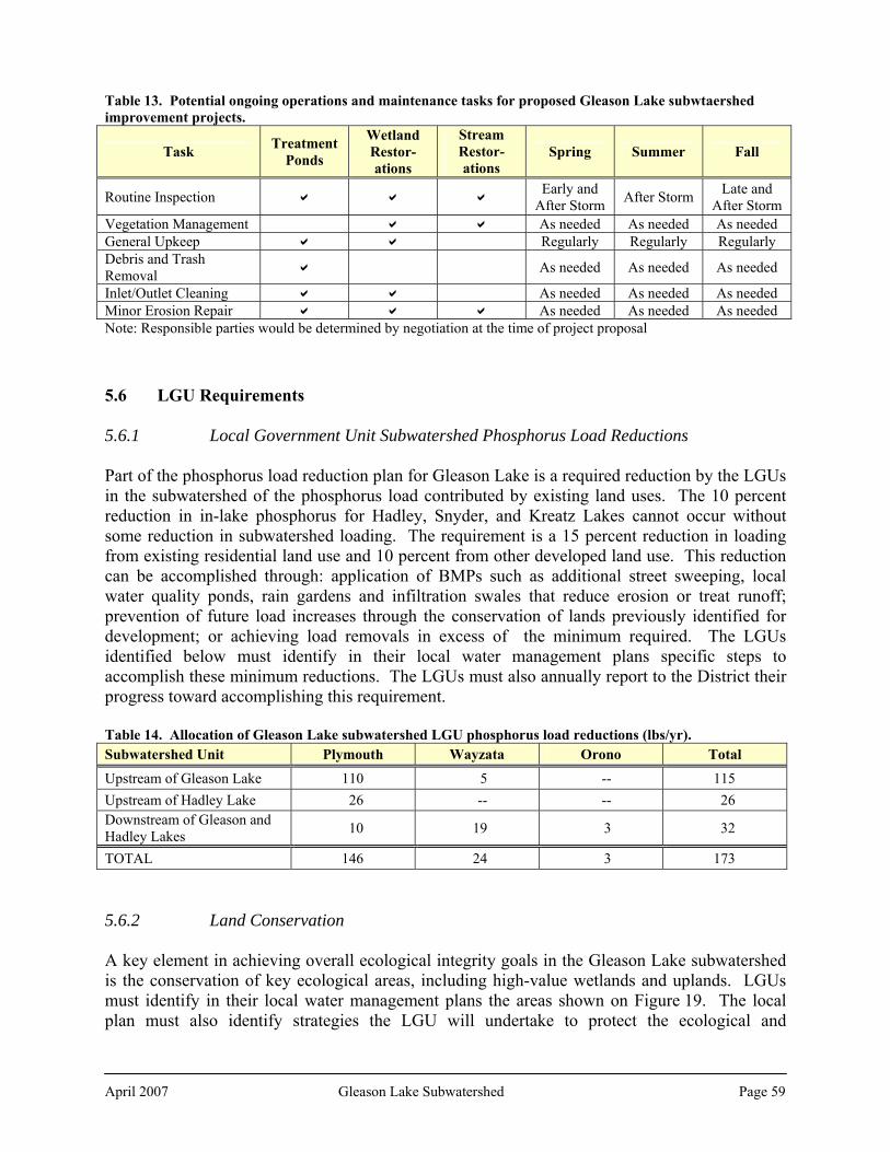
Table 13. Potential ongoing operations and maintenance tasks for proposed Gleason Lake subwtaershed improvement projects.
Task Treatment Ponds
Wetland Restor-ations
Stream Restor- ations
Spring Summer Fall
Routine Inspection Early and After Storm After Storm Late and
After Storm Vegetation Management As needed As needed As needed General Upkeep Regularly Regularly Regularly Debris and Trash Removal As needed As needed As needed
Inlet/Outlet Cleaning As needed As needed As needed Minor Erosion Repair As needed As needed As needed Note: Responsible parties would be determined by negotiation at the time of project proposal 5.6 LGU Requirements 5.6.1 Local Government Unit Subwatershed Phosphorus Load Reductions Part of the phosphorus load reduction plan for Gleason Lake is a required reduction by the LGUs in the subwatershed of the phosphorus load contributed by existing land uses. The 10 percent reduction in in-lake phosphorus for Hadley, Snyder, and Kreatz Lakes cannot occur without some reduction in subwatershed loading. The requirement is a 15 percent reduction in loading from existing residential land use and 10 percent from other developed land use. This reduction can be accomplished through: application of BMPs such as additional street sweeping, local water quality ponds, rain gardens and infiltration swales that reduce erosion or treat runoff; prevention of future load increases through the conservation of lands previously identified for development; or achieving load removals in excess of the minimum required. The LGUs identified below must identify in their local water management plans specific steps to accomplish these minimum reductions. The LGUs must also annually report to the District their progress toward accomplishing this requirement. Table 14. Allocation of Gleason Lake subwatershed LGU phosphorus load reductions (lbs/yr). Subwatershed Unit Plymouth Wayzata Orono Total
Upstream of Gleason Lake 110 5 -- 115 Upstream of Hadley Lake 26 -- -- 26 Downstream of Gleason and Hadley Lakes 10 19 3 32
TOTAL 146 24 3 173 5.6.2 Land Conservation A key element in achieving overall ecological integrity goals in the Gleason Lake subwatershed is the conservation of key ecological areas, including high-value wetlands and uplands. LGUs must identify in their local water management plans the areas shown on Figure 19. The local plan must also identify strategies the LGU will undertake to protect the ecological and
April 2007 Gleason Lake Subwatershed Page 59

hydrological values of those areas. These may include such strategies as land use regulation; acquisition and management; conservation easements; ecological restoration; and property owner education regarding land management strategies to maintain ecological integrity. 5.6.3 Other Issues
Modeled High Water Locations. The HHPLS identified a number of locations where modeling predicts that public roads, private roads, or private drives might overtop during infrequent events, or where there may be minimal freeboard above the flood level. Local plans should identify observed or these potential locations and assess whether the risk of occasional flooding is acceptable or should be addressed. Flow Velocity or Erosion Issues. The HHPLS identified a number of locations where modeling predicts that under existing or future development conditions higher velocities than desired ay result in erosion at outlets or culverts, potentially warranting erosion control or energy dissipation. Local plans should identify observed or these potential locations, assess the need for such measures, and set forth a plan for preventing future erosion. 5.7 Phosphorus Load Reduction One of the water quality goals for this subwatershed is the achievement of the Gleason Lake in-lake phosphorus concentration interim goal of 80 μg/L. Reduction of phosphorus loads from the subwatershed to achieve that goal will require the combined efforts of the regulatory program, loading reduction allocations to LGUs, operational programs, and capital projects. Table 15 below sets forth a summary plan for how this could be accomplished. The table breaks down modeled phosphorus loading in the subwatershed by source: atmospheric deposition, external sources, and internal sources. Atmospheric deposition is a regional issue and is not dealt with here. The primary means of addressing external loading are through the regulation of new loads generated by development, the reduction of existing loads from the subwatershed, and control of internal load. Application of the current regulatory program to new development would reduce the expected load from ultimate development conditions. The Gleason Lake Management Plan identified a number of potential improvements that could be considered which together would result in a substantial decreasing in phosphorus load form the subwatershed. In addition, a new detention pond on Ditch #15 just north of CR 6 could provide a significant phosphorus load reduction. It is important to note that a significant share of the modeled phosphorus load to Gleason Lake is from sources that have not been specifically identified. The phosphorus load contributed by wash off from land within the subwatershed is not sufficient to explain the current in-lake phosphorus concentration. The most likely sources for this discrepancy are internal loading from lake sediments or aquatic vegetation. This lake is not a good candidate for application of an alum treatment to control sediment sources. There is a significant amount of curlyleaf pondweed in the lake, and control of that invasive plant often can significantly reduce internal phosphorus.
April 2007 Gleason Lake Subwatershed Page 60
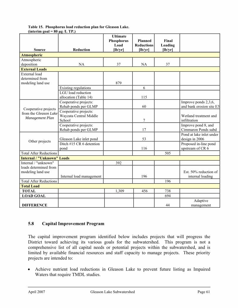
Table 15. Phosphorus load reduction plan for Gleason Lake. (interim goal = 80 μg /L TP.)
Source Reduction
Ultimate Phosphorus
Load [lb/yr]
Planned Reductions
[lb/yr]
Final Loading [lb/yr]
Atmospheric Atmospheric deposition NA 37 NA 37 External Loads External load determined from modeling land use 879
Existing regulations 6
LGU load reduction allocation (Table 14) 115 Cooperative projects: Rehab ponds per GLMP 60
Improve ponds 2,3,6, and bank erosion site E3
Cooperative projects: Wayzata Central Middle School 7
Wetland treatment and infiltration
Cooperative projects from the Gleason Lake
Management Plan
Cooperative projects: Rehab ponds per GLMP 17
Improve pond 8, and Cimmaron Ponds subd
Gleason Lake inlet pond 53 Pond at lake inlet under design in 2006 Other projects
Ditch #15 CR 6 detention pond 116
Proposed in-line pond upstream of CR 6
Total After Reductions 505 Internal / "Unknown" Loads
392 Internal / "unknown" loads determined from modeling land use Internal load management 196
Est. 50% reduction of internal loading
Total After Reductions 196 Total Load TOTAL 1,309 456 738 LOAD GOAL 694
DIFFERENCE 44 Adaptive
management
5.8 Capital Improvement Program
The capital improvement program identified below includes projects that will progress the District toward achieving its various goals for the subwatershed. This program is not a comprehensive list of all capital needs or potential projects within the subwatershed, and is limited by available financial resources and staff capacity to manage projects. These priority projects are intended to: • Achieve nutrient load reductions in Gleason Lake to prevent future listing as Impaired
Waters that require TMDL studies.
April 2007 Gleason Lake Subwatershed Page 61
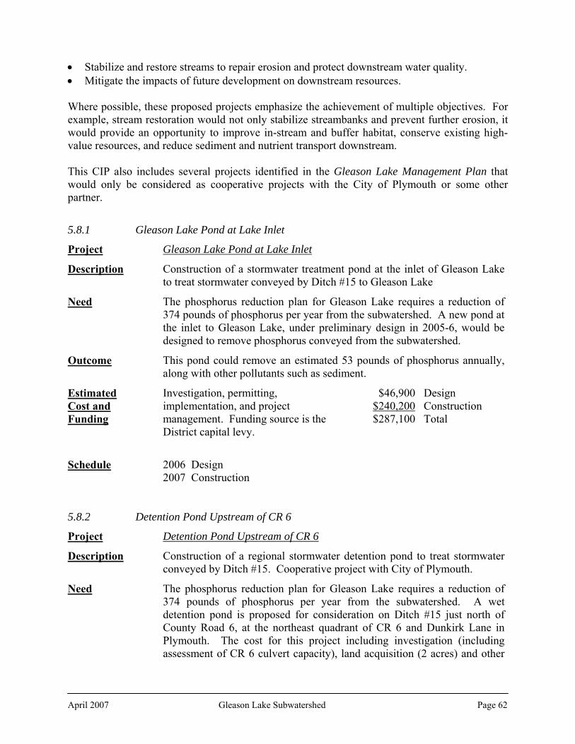
• Stabilize and restore streams to repair erosion and protect downstream water quality. • Mitigate the impacts of future development on downstream resources. Where possible, these proposed projects emphasize the achievement of multiple objectives. For example, stream restoration would not only stabilize streambanks and prevent further erosion, it would provide an opportunity to improve in-stream and buffer habitat, conserve existing high-value resources, and reduce sediment and nutrient transport downstream. This CIP also includes several projects identified in the Gleason Lake Management Plan that would only be considered as cooperative projects with the City of Plymouth or some other partner.
5.8.1 Gleason Lake Pond at Lake Inlet
Project Gleason Lake Pond at Lake Inlet
Description Construction of a stormwater treatment pond at the inlet of Gleason Lake to treat stormwater conveyed by Ditch #15 to Gleason Lake
Need The phosphorus reduction plan for Gleason Lake requires a reduction of 374 pounds of phosphorus per year from the subwatershed. A new pond at the inlet to Gleason Lake, under preliminary design in 2005-6, would be designed to remove phosphorus conveyed from the subwatershed.
Outcome This pond could remove an estimated 53 pounds of phosphorus annually, along with other pollutants such as sediment.
Estimated Cost and Funding
Investigation, permitting, implementation, and project management. Funding source is the District capital levy.
$46,900 Design $240,200 Construction $287,100 Total
Schedule 2006 Design 2007 Construction
5.8.2 Detention Pond Upstream of CR 6
Project Detention Pond Upstream of CR 6
Description Construction of a regional stormwater detention pond to treat stormwater conveyed by Ditch #15. Cooperative project with City of Plymouth.
Need The phosphorus reduction plan for Gleason Lake requires a reduction of 374 pounds of phosphorus per year from the subwatershed. A wet detention pond is proposed for consideration on Ditch #15 just north of County Road 6, at the northeast quadrant of CR 6 and Dunkirk Lane in Plymouth. The cost for this project including investigation (including assessment of CR 6 culvert capacity), land acquisition (2 acres) and other
April 2007 Gleason Lake Subwatershed Page 62

costs is estimated to be $536,000. This pond is proposed as a joint project with the City of Plymouth.
Outcome This pond could remove an estimated 116 pounds of phosphorus annually, along with other pollutants such as sediment.
Estimated Cost and Funding
Investigation, land acquisition, permitting, implementation, and project management. Funding source is the District capital levy and the City of Plymouth. The specific share of construction costs as well as ongoing maintenance costs associated with this pond would be determined by cooperative agreement prior to implementation of this project.
$76,900 Design, ROW $513,400 Construction $590,300 Total
Schedule 2009 Design, easement acquisition, cooperative agreement 2010 Construction
5.8.3 Gleason Lake Management Plan Projects
Project Gleason Lake Management Plan Cooperative Projects
Description Detention pond maintenance to restore and improve pollutant removal efficiency, and restoration of a portion of eroded Ditch #15. Cooperative projects with City of Plymouth.
Need The Gleason Lake Management Plan identified a number of improvements to be undertaken in the subwatershed that together could significantly reduce phosphorus loading to Gleason Lake. Of particular emphasis was dredging existing stormwater ponds to regain and/or increase pollutant removal efficiency. Specific ponds identified as priorities for improvement include those described in the plan as Pond 2 (west of Dunkirk La, between 24th and 25th Avenues N), Pond 3 (of 25th Avenue N, between Fountain and Garland Avenues N), and Pond 6 (west of Dunkirk La, north of 19th Avenue N); improving Pond 8 (west of Vicksburg, La southwest of 9th and 8th Avenues N) and the Cimarron Ponds (west of Vicksburg La, between 10th and 12th Avenues N); and repairing the eroded Ditch #15 reach E3 (west Of Dunkirk La, between 22nd and 24th Avenues N). As detailed in the Gleason Lake Management Plan, these projects are proposed as joint projects with the City of Plymouth. The specific share of construction cost as well as ongoing maintenance costs associated with these improvements would be determined by cooperative agreement prior to implementation of this project.
Outcome Together these improvements are estimated to remove 77 pounds of phosphorus annually, along with other pollutants such as sediment.
April 2007 Gleason Lake Subwatershed Page 63

Estimated Cost
Investigation, permitting, implementation, and project management. Funding source is the District capital levy and the City of Plymouth. The specific share of construction costs as well as ongoing maintenance costs associated with these improvements would be determined by cooperative agreement prior to implementation of this project.
$566,500
Schedule 2010 Design, cooperative agreement 2011 Construction
5.8.4 Gleason Lake Internal Load Management
Project Gleason Lake Internal Load Management
Description Design and implementation of strategies to reduce internal phosphorus loading, including: feasibility study; aquatic vegetation survey update and management plan; fishery survey update and management plan; biomanipulation strategies that may include aquatic vegetation management, zooplankton community and fishery manipulation, and chemical treatment.
Need The Gleason Lake Management Plan prepared in 2003 identified the reduction in phosphorus load to Gleason Lake both from the subwatershed and internal sources as a top priority. Gleason Lake is a shallow lake, and management of its internal load will require different strategies than for deeper lakes. This project would identify and implement a suite of strategies to manage aquatic vegetation, the fishery, and zooplankton community to achieve water quality and clarity goals. The project includes an ongoing vegetation and fishery management plan. Management of invasive aquatic vegetation that contributes to lake water quality and usability issues would require annual treatment for three to five years.
Outcome Reduction in phosphorus load from internal sources estimated at 196 pounds annually; improved water clarity; more diverse aquatic vegetation community; improved aesthetics.
Estimated Cost
Development of plans and implementation of strategies. Source of funds is District capital levy.
$35,800
Schedule 2013 Fish, vegetation, and zooplankton surveys, development of management plans, cooperative agreement
2014 Implementation of strategies
April 2007 Gleason Lake Subwatershed Page 64

April 2007 Gleason Lake Subwatershed Page 65
5.8.5 Regional Infiltration
Project Gleason Lake Regional Infiltration
Description Implementation of opportunities to increase infiltration, including but not limited to construction of infiltration basins and devices, wetland restoration, reforestation, revegetation.
Need The proposed rule requiring new development and redevelopment to infiltrate one inch of rainfall would capture approximately 70 percent of new runoff volume from the watershed. The remaining 30 percent would continue to convey pollutants to Gleason Lake and other resources in the watershed. To minimize this pollutant loading and to minimize new stormwater volumes generated from the subwatershed, regional infiltration opportunities such as wetland restoration, underground storage and infiltration, or native vegetation restoration and reforestation may be necessary. Prior to implementing any of these options, opportunities in the subwatershed should be investigated for the most cost-effective and suitable locations. Regional infiltration will be focused on those subwatershed units that are expected to see significant new runoff volumes between 2000 and ultimate development.
Outcome Minimized new pollutant loads conveyed by new runoff; minimized new volumes generated by new development; prevention of potential future stream and channel erosion; protection of stream base flows and wetland and surficial groundwater hydrology; wetland restorations; conservation of high-value native vegetation and habitat.
Project 1: Improvements in GLC-4. Funding source is District capital levy.
$179,700 Estimated Cost and Funding Project 2: Improvements in GLC-9. Funding source
is District capital levy. $32,900
Schedule 2009: Identify and construct improvements in GL-4 2012: Identify and construct improvements in GL-9
5.9 Summary The following tables summarize the proposed implementation action items, their relationship to the problems and issues identified in Section 3.0 above, the metrics by which the District will be evaluating progress toward resolving those issues and problems, the estimated District costs of implementing those actions, and anticipated implementation schedule.

Table 16. Problems and issues identified in the Gleason Lake subwatershed and actions proposed to address them. April 2007
Gleason Lake Subw
atershed Page 66
Problem or Issue Actions in Implementation Plan Degree of Improvement The water quality in Gleason Lake has consistently been scored in the C-D grade range on the District’s annual lake report cards. Based on this monitoring history Gleason Lake’s water quality is not supportive of swimming
• A phosphorus load reduction plan for Gleason Lake that sets forth actions to reduce loading to meet in-lake P concentration goals. These actions include an enhanced regulatory program, LGU requirements to reduce phosphorus form existing development, and capital projects to reduce internal and external loads.
• Continue monitoring Gleason Lake and Gleason Lake Creek, and obtain baseline data for other lakes through Citizen Assisted Monitoring program or satellite data.
• Implementation of all the actions in the phosphorus load reduction plan would theoretically reduce in-lake P concentrations, improve water clarity, and meet District water quality goals.
• Baseline data would fill a data gap and provide for tracking water quality trends across the subwatershed
Development and redevelopment in the subwatershed will increase nutrient and TSS loads from the watershed as well as increasing the volume of stormwater runoff.
Rules will be amended to require more stringent pollutant load reduction on new development and redevelopment, including adding a volume management requirement to reduce pollutant transport
Would depend on ability of developers to incorporate adequate BMPs on their projects and properly maintain them to sustain removal efficiencies.
Gleason Lake Creek conveys significant phosphorus and sediment loads downstream, and dissolved oxygen can fall below the state standard during low flows.
Rules will be amended to require more stringent pollutant load reduction on new development and redevelopment, including adding a volume management requirement to reduce pollutant transport
Would depend on ability of developers to incorporate adequate BMPs on their projects and properly maintain them to sustain removal efficiencies.
Wat
er Q
ualit
y
The Gleason Lake Management plan identified some areas of shoreline erosion on Gleason Lake that could be contributing to reductions in lake water clarity and increased pollutant loading
Update the shoreline erosion survey as part of internal load diagnostic and feasibility study and assess impacts on water quality
Would depend on extent of problem and willingness of shoreline property owners to implement improvements
• Rules will be amended to require more stringent pollutant load reduction on new development and redevelopment, including adding a volume management requirement.
• Would depend on ability of developers to incorporate adequate BMPs on their projects and properly maintain them to sustain removal efficiencies.
The HHPLS channel erosion survey on Ditch #15 identified five erosion locations, including two that were of a high level of concern. Gleason Lake outlets through Gleason Creek, and the Upper Watershed Stream Assessment identified five erosion locations on Gleason Creek. • Cooperatively construct regional infiltration
improvements to mitigate impact of new runoff from development.
• Work cooperatively with LGUs to restore spot erosion problems
• Cooperatively construct stream stabilization project on Ditch #15.
• Depends on extent of problem and ability to develop cooperative or collaborative improvements.
Wat
er Q
uant
ity
The HHPLS identified a number of ponding locations that are predicted to overtop during the 100-year event, as well as others with a minimal amount of freeboard.
LGUs directed to evaluate these locations as part of their local water management planning.
Completed as LGUs complete their local plans.

Problem or Issue Actions in Implementation Plan Degree of Improvement Development, redevelopment, and reconstruction in the subwatershed in areas of potential development may increase volume of stormwater runoff from the subwatershed as well as increasing nutrient and sediment loads.
• Rules will be amended to require more stringent pollutant load reduction on new development and redevelopment, including adding a volume management requirement.
• Cooperatively construct regional infiltration improvements to mitigate impact of new runoff from development.
Would depend on ability of developers to incorporate adequate BMPs on their projects and properly maintain them to sustain removal efficiencies.
The HHPLS identified two locations where for both existing and future conditions higher velocities than desired may result in erosive velocities at outlets or culverts.
LGUs directed to evaluate these locations as part of their local water management planning.
Completed as LGUs complete their local plans.
• Key Conservation Areas identified that include high-value wetlands. In key areas, LGUs are required to include in their local plans strategies for conserving these values.
• Ongoing effort that is dependant on property owner willingness to pursue conservation, District budget and staff capacity, and LGU plan completion.
The subwatershed includes Preserve classification wetlands adjacent to Gleason Lake that provide high to exceptional fish habitat and aesthetic values that should be protected.
• Rules will be amended to establish management standards based on management classification for impacts to wetlands from development and redevelopment.
• Implementation of revised rules would help minimize future impacts to the highest-value wetlands while still providing a measure of protection to those that provide mainly downstream resource protection.
Wet
land
s
Wetlands with high to moderate restoration potential should be considered for protection and restoration.
Wetlands identified as being of high to moderate wetland potential would be managed according to a Manage 1 wetland classification if they have been assessed as a Manage 2 or 3. This would minimize further degradation that might make future restoration more difficult or costly.
No wetlands are identified for restoration in this Plan cycle.
Eco
logi
cal I
nteg
rity
Few opportunities are available to conserve minimally disturbed landscapes, but there are potential restoration opportunities to improve and increase habitat; native vegetation restoration along the upper watershed channel corridor for streambank stability, erosion control, and habitat connectivity; and urban forest preservation and restoration to increase evapotranspiration and reduce runoff.
Key Conservation Areas identified that include high-value wetlands. In key areas, LGUs are required to include in their local plans strategies for conserving these values.
Ongoing effort that is dependant on property owner willingness to pursue conservation, District budget and staff capacity, and LGU plan completion.
April 2007
Gleason Lake Subw
atershed Page 67

Problem or Issue Actions in Implementation Plan Degree of Improvement Wetlands with high ecological value are present and those wetlands and associated upland areas should be conserved to preserve their values and create larger areas of ecological value
Key Conservation Areas identified that include high-value wetlands. In key areas, LGUs are required to include in their local plans strategies for conserving these values.
Ongoing effort that is dependant on property owner willingness to pursue conservation, District budget and staff capacity, and LGU plan completion.
The Gleason Lake fishery was last surveyed in 1996 and revealed a panfish fishery that could be improved through a piscavore stocking program
• Support the fishery through improvement of water quality, management of aquatic vegetation where internal load management is required, and the promotion of shoreline restoration.
• Evaluate need for fishery management to control internal phosphorus loading as part of the Gleason Lake diagnostic and feasibility studies.
• Work cooperatively with the DNR on fishery management issues
Depends on response of natural system to improved water quality
Eurasian water milfoil is present in the lake as is curly leaf pondweed
• Evaluate vegetation management as part of internal load management diagnostic and feasibility study.
Depends on the extent of infestation. If control of milfoil, CLP and other invasive aquatic vegetation will help achieve internal phosphorus load reduction goals, then a significant improvement can be had through chemical or other control. If control would not benefit lake water quality, then there would be no improvement.
An aquatic plant survey conducted for the Gleason Lake Management Plan revealed a significant vegetative community dominated by coontail
Periodically update aquatic plant survey Completion of these surveys would assist in ongoing internal load management
Gro
undw
ater
Many of the major wetlands in the subwatershed were identified in the FAW as combination recharge-discharge wetlands. As development occurs it will be important to maintain runoff and infiltration rates to help maintain hydrology to these wetlands.
• Amend rules to require infiltration or abstraction of the first one inch of rainfall on new permitted development and redevelopment.
• Identify a network of surficial aquifer monitoring wells across the watershed, monitor groundwater levels and quality.
• Promote Better Site Design (Low Impact Development) principles for new development that mimic predevelopment hydrologic regime.
• Infiltration on site will assist in preventing further modification of surficial groundwater recharge and help to maintain wetland hydrologic regimes.
April 2007
Gleason Lake Subw
atershed Page 68

April 2007
Gleason Lake Subw
atershed Page 69
Problem or Issue Actions in Implementation Plan Degree of Improvement Several wetland areas in the Hadley Lake watershed are in highly sensitive aquifer impact areas Several wetland areas in the Hadley Lake watershed are in highly sensitive aquifer impact areas
• Amend rules to require pretreatment of stormwater discharged to wetlands or infiltration areas in the areas of high aquifer sensitivity.
• Establish a new District rule that requires an additional level of analysis and review of permitted development and redevelopment where there is a potential for development to adversely impact groundwater connected to a surface water feature.
Will help minimize future impacts to groundwater and provide for proactive management rather than reactive
Almost the entire subwatershed is identified as a Wellhead Protection Area for the City of Plymouth.
Stormwater and groundwater management within those areas will be coordinated with wellhead protection plans.
Will help minimize future impacts to drinking water and provide for proactive management rather than reactive
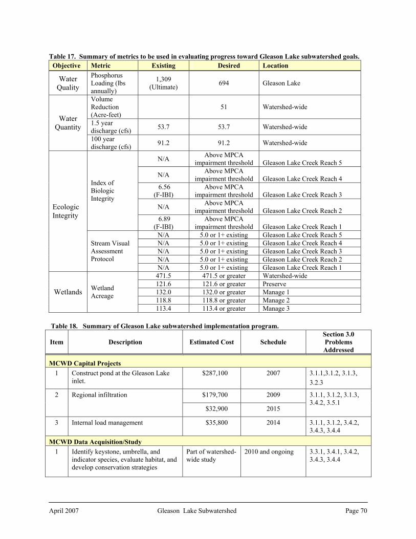
Table 17. Summary of metrics to be used in evaluating progress toward Gleason Lake subwatershed goals. Objective Metric Existing Desired Location
Water Quality
Phosphorus Loading (lbs annually)
1,309 (Ultimate) 694 Gleason Lake
Volume Reduction (Acre-feet)
51 Watershed-wide
1.5 year discharge (cfs) 53.7 53.7 Watershed-wide
Water Quantity
100 year discharge (cfs) 91.2 91.2 Watershed-wide
N/A Above MPCA impairment threshold Gleason Lake Creek Reach 5
N/A Above MPCA impairment threshold Gleason Lake Creek Reach 4
6.56 (F-IBI)
Above MPCA impairment threshold Gleason Lake Creek Reach 3
N/A Above MPCA impairment threshold Gleason Lake Creek Reach 2
Index of Biologic Integrity
6.89 (F-IBI)
Above MPCA impairment threshold Gleason Lake Creek Reach 1
N/A 5.0 or 1+ existing Gleason Lake Creek Reach 5 N/A 5.0 or 1+ existing Gleason Lake Creek Reach 4 N/A 5.0 or 1+ existing Gleason Lake Creek Reach 3 N/A 5.0 or 1+ existing Gleason Lake Creek Reach 2
Ecologic Integrity
Stream Visual Assessment Protocol
N/A 5.0 or 1+ existing Gleason Lake Creek Reach 1 471.5 471.5 or greater Watershed-wide 121.6 121.6 or greater Preserve 132.0 132.0 or greater Manage 1 118.8 118.8 or greater Manage 2
Wetlands Wetland Acreage
113.4 113.4 or greater Manage 3
Table 18. Summary of Gleason Lake subwatershed implementation program.
Item Description Estimated Cost Schedule Section 3.0 Problems Addressed
MCWD Capital Projects 1 Construct pond at the Gleason Lake
inlet. $287,100 2007 3.1.1,3.1.2, 3.1.3,
3.2.3
$179,700 2009 2 Regional infiltration
$32,900 2015
3.1.1, 3.1.2, 3.1.3, 3.4.2, 3.5.1
3 Internal load management $35,800
2014 3.1.1, 3.1.2, 3.4.2, 3.4.3, 3.4.4
MCWD Data Acquisition/Study 1 Identify keystone, umbrella, and
indicator species, evaluate habitat, and develop conservation strategies
Part of watershed-wide study
2010 and ongoing 3.3.1, 3.4.1, 3.4.2, 3.4.3, 3.4.4
April 2007 Gleason Lake Subwatershed Page 70

2 Develop infiltration/filtration strategies appropriate to wellhead protection areas and areas of groundwater sensitivity
Part of watershed-wide study
2008 3.1.2, 3.2.2, 3.2.3, 3.2.4, 3.4.1, 3.5.1, 3.5.2, 3.5.3
3 Identify potential locations within the subwatershed for future wetland restoration
Part of ongoing watershed-wide program
Part of ongoing watershed-wide program
3.2.2, 3.3.1, 3.4.1
MCWD Land Conservation Program 1 Undertake land conservation efforts in
accordance with Figure 19 No District priority areas in subwatershed
Part of ongoing watershed-wide program
3.3.1, 3.4.1, 3.5.1, 3.5.2
MCWD Regulatory Program 1 Amend District Rules to increase
stormwater management requirements for new development and redevelopment
Part of watershed-wide effort
2007-2009 3.1.1, 3.1.2, 3.1.3, 3.3.1, 3.4.1, 3.4.2, 3.4.3
2 Amend District Rules to require abstraction of 1” of rainfall from new development and redevelopment
Part of watershed-wide effort
2007-2009 3.1.3, 3.2.1, 3.2.3, 3.2.3, 3.2.4, 3.3.1, 3.4.1, 3.5.1
3 Amend District Rules to adopt wetland management rules based on wetland management classification
Part of watershed-wide effort
2007-2009 3.1.3, 3.2.3, 3.3.1, 3.4.1, 3.5.1
MCWD Hydrodata Program 1 Monitor Gleason Lake and Gleason
Creek Part of watershed-wide hydrologic data program
Part of ongoing watershed-wide program
3.1.1, 3.1.2, 3.2.1, 3.2.2
2 Obtain baseline water quality data for Hadley, Kreatz, and Snyder Lakes and update every 3-5 years
Part of watershed-wide hydrologic data program
Part of ongoing watershed-wide program
3.1.1, 3.1.2
3 Identify shallow wells to monitor groundwater levels
Part of watershed-wide study
2008 and ongoing 3.2.2, 3.2.3, 3.3.1, 3.4.1, 3.5.1
MCWD Education/Communication Program 1 Provide targeted education materials to
key stakeholder groups to meet objectives of plan
Part of watershed-wide education program
Part of ongoing watershed-wide program
All
2 Provide workshops, seminars, and brown bags for LGU staff, developers, and other interested parties
Part of watershed-wide education program
Part of ongoing watershed-wide program
All
3 Work cooperatively with the Gleason Lake Association
Part of watershed-wide education program
Part of ongoing watershed-wide program
All
4 Develop a small grant program to provide financial assistance to property owners desiring to implement BMPs on their property or to install demonstration projects on public property
Part of watershed-wide program
2008 and ongoing 3.1.3, 3.2.1, 3.2.3, 3.2.3, 3.2.4, 3.3.1, 3.4.1, 3.5.1
April 2007 Gleason Lake Subwatershed Page 71

MCWD Operations and Maintenance 1 Inspect Gleason Creek and Ditch #15
channel annually Ongoing activity Part of ongoing
watershed-wide program
3.1.1, 3.1.3, 3.2.1, 3.2.2, 3.2.3, 3.2.4
2 Monitor high vegetative-diversity wetlands for exotic species
Part of watershed-wide program
Part of ongoing watershed-wide program
3.4.1
3 Maintain detention ponds to sustain removal efficiency
Ongoing for existing projects. Incorporate into life-cycle cost of new projects.
As set forth in Cooperative Agreement
3.1.1, 3.1.2, 3.1.3
Collaborative Projects 1 Construct pond and ditch
improvements identified in the Gleason Lake Management Plan
$503,000 Share cost with
Plymouth
2011 3.1.1, 3.1.2, 3.1.3 3.2.1, 3.2.3
2 Construct pond on Ditch #15 upstream of CR 6
$590,300 Share cost with
Plymouth
2010 3.1.1, 3.1.2, 3.1.3, 3.2.3
3 Work cooperatively with cities to identify and repair erosion on Gleason Creek and Ditch #15
Part of watershed-wide program
2008 and ongoing 3.1.1, 3.1.3, 3.2.1, 3.2.2, 3.2.3, 3.2.4
4 Turn back County Ditch #15 and #32 to Plymouth and Wayzata, respectively
Ongoing activity 2008 3.2.1
April 2007 Gleason Lake Subwatershed Page 72

April 2007 Gleason Lake Subwatershed Page 73
April 2007 Gleason Lake Subwatershed Page 73