ghana national spatial development framework (2015 …
TRANSCRIPT
GOVERNMENT OF GHANA MINISTRY OF LAND AND NATURAL RESOURCES
MINISTRY OF ENVIRONMENT, SCIENCE, TECHNOLOGY AND INNOVATION
TOWN AND COUNTRY PLANNING DPARTMENT
NATIONAL DEVELOPMENT PLANNING COMMISSION
FEBRUARY, 2015
GHANA NATIONAL SPATIAL DEVELOPMENT FRAMEWORK
(2015-2035)
Executive Summary
REPUBLIC OF GHANA


Government of Ghana Ministry of Lands and Natural Resources Ministry of Environment, Science, Technology and Innovation Town and Country Planning Department National Development Planning Commission
Land Administration Project II
National Spatial
Development Framework 2015-2035
Space, Efficiency and Growth
FINAL REPORT
Volume III:
EXECUTIVE SUMMARY (OF VOL I AND VOL. II)
Credit #: IDA 4870 GH
Land Administration Project
Funded by the International Development Association (IDA)


Volume I Ghana National Spatial Development Framework 2015-2035
Land Administration Project II
National Spatial Development
Framework 2015-2035
Space, Efficiency and Growth FINAL REPORT
Volume III:
EXECUTIVE SUMMARY (OF VOL I AND VOL. II) THE FINAL REPORT CONSISTS OF THREE VOLUMES: Volume I: Space, Efficiency and Growth Volume II: Overall Spatial Development Strategy Volume III: Executive Summary of Vol I and Vol II Annexes: Annex 1: MS Excel Sheets for the NSDF phasing Cost Estimates Annex 2: Strategic Environmental Assessment of NSDF
ADDRESS COWI A/S
Parallelvej 2
2800 Kongens Lyngby
Denmark
TEL +45 56 40 00 00
FAX +45 56 40 99 99
WWW cowi.com

Volume I Ghana National Spatial Development Framework 2015-2035
Volume I Ghana National Spatial Development Framework 2015-2035
CONTENTS
1 Introduction .................................................................................................................................. 1-14
2 Spatial development challenges and opportunities ...................................................................... 2-14
2.1 Introduction ......................................................................................................................... 2-14
2.2 Economic challenges and opportunities ............................................................................. 2-14
2.3 Population distribution and growth ..................................................................................... 2-15
2.4 Urban and rural settlement distribution and growth ........................................................... 2-15
2.5 Increasing food production ................................................................................................. 2-18
2.6 Transportation..................................................................................................................... 2-18
2.7 National and regional land cover ........................................................................................ 2-19
2.8 Mining ................................................................................................................................. 2-19
2.9 Natural and cultural heritage assets ................................................................................... 2-19
2.10 Education ............................................................................................................................ 2-19
2.11 Health facilities.................................................................................................................... 2-20
3 Objectives and pillars of spatial strategy ..................................................................................... 3-20
3.1 What is national spatial planning? ...................................................................................... 3-20
3.2 The National Spatial Development Framework .................................................................. 3-21
3.3 Tools and instruments of spatial planning .......................................................................... 3-21
3.4 Pillars of the national spatial development strategy ........................................................... 3-22
4 Place-based framework............................................................................................................... 4-23
4.1 General spatial development policies ................................................................................. 4-25
4.2 Urban Settlement Hierarchy ............................................................................................... 4-25
4.2.1 NSDF urban settlement hierarchy criteria and selection ................................................ 4-25
4.2.2 NSDF urban settlement hierarchy .................................................................................. 4-26
4.3 Abidjan-Accra-Lagos coastal megaregion or urban corridor .............................................. 4-28
4.4 Two city-regions around Accra and Kumasi ....................................................................... 4-30
4.4.1 Accra City-Region ........................................................................................................... 4-30

Volume I Ghana National Spatial Development Framework 2015-2035
4.4.2 Greater Kumasi Sub-Region (GKSR) and Greater Kumasi Conurbation.......................... 32
4.4.3 Recommendations for city regions ................................................................................. 4-34
4.5 Urban Networks .................................................................................................................. 4-34
5 Important National Initiatives ....................................................................................................... 5-45
5.1 A national and international expressway system ............................................................... 5-45
5.2 Upgraded and improved trunk roads .................................................................................. 5-46
5.3 A national and international rail network ............................................................................ 5-46
5.4 Two international airports ................................................................................................... 5-47
5.5 New Airport City at Centre of Triangle ................................................................................ 5-47
5.6 Options for three new seaports .......................................................................................... 5-48
5.7 Green infrastructure Network ............................................................................................. 5-48
5.8 Agricultural Growth Corridor ............................................................................................... 5-49
5.9 Proposed urban food sheds ............................................................................................... 5-49
5.10 Alternative Energy Projects ................................................................................................ 5-49
6 NSDF phasing and cost estimates .............................................................................................. 6-51
6.1 Introduction ......................................................................................................................... 6-51
6.2 Phasing and population growth .......................................................................................... 6-51
6.3 Future distribution of population in Ghana ......................................................................... 6-51
6.4 Evaluation of needed resources for infrastructure development ........................................ 6-53
6.4.1 Definition of cost units for land and infrastructure .......................................................... 6-55

Volume I Ghana National Spatial Development Framework 2015-2035
List of Figures and Tables of Volume II
Figure/Table # Title Page #
Figure 2.1 Urban settlement size-classes and population growth rates 2-17
Figure 2.2 Rural settlement distribution and population distribution 2-18
Figure 4.1 NSDF Spatial Development Concept 4-25
Figure 4.2 NSDF Settlement hierarchy (compared to NUPs) 4-28
Figure 4.3 Abidjan-Accra-Lagos coastal megaregion 4-30
Figure 4.4 Accra City-Region 4-32
Figure 4.5 Kumasi City-Region 4-34
Table 4.2 City Region and Network Metrics 4-36
Figure 4.6 Sunyani Urban Network 4-38
Figure 4.7 North-East Urban Network 4-39
Figure 4.8 Aflao Urban Network 4-40
Figure 4.9 Ho-Hohoe Urban Network 4-41
Figure 10 STMA Urban Network 4-42
Figure 4.11 Tamale Urban Network 4-43
Figure 4-12 Wa Urban Network 4-44
Figure 4.13 Cape Coast Urban Network 4-45
Figure 6.1 Projected GDP development in Ghana 2105 to 35 6-54
Table 6.1 Percentage (%) of investments in sectors 2016-35 6-55

Volume I Ghana National Spatial Development Framework 2015-2035
Acronyms and Abbreviations ADT Average Daily Traffic
AGC Associated General Contractors of America
ASDP Atlantic Spatial Development Perspective
AUE Atlas of Urban Expansion
BRT Bus Rapid Transit
CBD Central Business District
CBO Community Based Organisation
CCTV Closed Circuit Television
CERGIS Centre for Remote Sensing and Geographic Information Services
CET Central European Time
CHAG Christian Health Association of Ghana
CIDA Canadian International Development Agency
CMC Commercial Metals Company
CRC Coastal Resource Centre
CSIR Council for Industrial and Scientific Research
CSO Civil Society Organisation
DFO Direct Factory Outlets
DRF Daily Racing Form
ECOWAS Economic Commission of West African States
EPA Environment Protection Agency
ERP Enterprise Resource Planning
ESPON European Spatial Planning Observation Network
ETLS ECOWAS Trade Liberalisation Scheme
EU European Union
FAO Food and Agricultural Organisation
FASDEP Food and Agricultural Sector Development Policy
FCUBE Free Compulsory Universal Basic Education
FDI Foreign Direct Investment
GAMA Greater Accra Metropolitan Area
GCAP Ghana Commercial Agricultural Project
GDP Gross Domestic Product
GHA Ghana Highways Authority
GIDA Ghana Irrigation Development Authority
GIN Group Interactive Network
GIPC Ghana Investment Promotion Council
GIS Geographic Information Systems
GKUDP Greater Kumasi Urban Development Plan
GLDP Greater London Development Plan
GLSS Ghana Living Standard Survey
GNP Gross National Product
GPS Global Positioning System
GREL Ghana Rubber Estates Limited
GRMP Ghana Railway Master Plan
GSGDA Ghana Shared Growth and Development Agenda
GSS Ghana Statistical Service
GWCL Ghana Water Company Limited
ICFG Integrated Coastal and Fisheries Governance Initiative
ICT Information and Communication Technology
Volume I Ghana National Spatial Development Framework 2015-2035
IIASA International Institute for Applied Systems Analysis
IMF International Monetary Fund
IPCC International Panel of Climate Change
IS Information System(s)
ISSER Institute of Statistical, Social and Economic Research, University of Ghana
ITP Integrated Transportation Plan
JV Joint Venture COWIOrgut TA team
KIA Kotoka International Airport
KVIP Improve Ventilated Pit Latrine
LAP Land Administration Project
LED Local Economic Development
LPG Liquified Petroleum Gas
LULUCF Land use, land use change and forestry
LUPMIS Land Use Planning and Management Information System
LUPMP Land Use Planning and Management Project
LUSPA Land Use and Spatial Planning Act
LUSPB Land Use and Spatial Planning Bill
MDA Ministries, Departments and Agencies
MDG Millennium Development Goals
MESTI Ministry of Environment, Science, Technology and Innovation
METASIP Medium Term Agricultural Sector Investment Plan
MGI McKinsey Global Initiative
MLNR Ministry of Lands and Natural Resources
MMDA Metropolitan, Municipal and District Assembly
MMT Multimedia Technology
MOFA Ministry of Food and Agriculture
MSE Mean Squared Error
MTDP Medium-Term National Development Plan
MTNDPF Medium-Term National Development Policy Framework
MW Mega Watt
NDP National Development Plan
NDPC National Development Planning Commission
NGO None Governmental Organisation
NIP National Infrastructure Plan
NITA National Information Technology Agency
NLTDS National Long-Term Development Strategy
NPC National Population Council
NPDP National Physical Development Plan
NPF National Planning Framework
NPP New Patriotic Party
NSDC National Security and Defence Council
NSDF National Spatial Development Framework
NSDI National Spatial Data Infrastructure
NSDP National Spatial Development Perspective
NTC National Technical Committee
NTP National Transport Plan
NUP National Urban Policy
ODA Official Development Assistance
RCC Regional Coordinating Council

Volume I Ghana National Spatial Development Framework 2015-2035
RD Registered Dieticians
ROC Regional Oversight Committee
RPCU Regional Planning and Coordinating Units
SADA Savannah Accelerated Development Authority
SAP Systems Applications and Products
SDF Spatial Development Framework
SfDR Support for Democratic Reforms (a GIZ project)
SFIP Small Farms Irrigation Project
SFIP Standard Flood Insurance Policy
SHS Senior High School
SIP Social Investment Project
SRI Soil Research Institute
SSIDP Small Scale Irrigation Development Project
SSIDP South Sudan Institute of Democracy and Peace
STMA Sekondi-Takoradi Metropolitan Area
TA Technical Assistance
TCPD Town and Country Planning Department
TOD Transit Oriented Development
TSIP Traffic Safety Improvement Program
UAE United Arab Emirates
UEMOA West African Economic and Monetary Union
UNCTAD United Nation Conference on Trade and Development
UNDP United Nations Development Programme
UNFPA United Nations Population Fund
UNU United Nations University
UTM Universal Transverse Mercator
UTP Unlisted Trading Privileges
VKT Vehicle kilometres travelled
WBGUR World Bank Ghana Urbanisation Review
WC Water Closet
WDR World Development Report
WFP World Food Programme
WRSDF Western Region Spatial Development Framework
YIAP Youth in Agriculture Programme

Volume III Executive Summary Ghana National Spatial Development Framework 2015-2035
1-10
Foreword by the Hon. Minister, MESTI
The central purpose of the Government of Ghana is to harness the enormous potential of the
country for sustainable and equitable socio-economic transformation, and provide, opportunities
for all to progress and enjoy a good quality of life. Our new land use and spatial planning system,
and soon to be approved Land Use and Spatial Planning Bill are geared towards the
accomplishment of this purpose.
The National Spatial Development Framework (NSDF), at the apex of our spatial planning
system, is a long-term, 20-year strategy for the spatial development of Ghana. It has been
informed by: (i) our Medium-Term National Development Policy Frameworks, the Ghana Shared
Growth Development Agenda's I and II, which set out the overall measures we are taking to
accelerate Ghana's development; (ii) our sectoral plans and policies in areas such as economy,
transport, education, health, environment, energy, climate change and land use; and (iii) the
views of several government agencies at the national, regional and district levels, particularly
those that participated in the country-wide consultations undertaken by the NSDF team.
Now that NSDF is completed, I would expect it will contribute to the National Long-Term
Development Strategy (NLTDS), currently being prepared under the leadership of the National
Development Planning Commission. NSDF is an important document, one that will influence
orderly development plans across the country and provide guidance to deliver the change that the
country yearns for. By providing a comprehensive analysis of the existing situation and trends, the
document can be used to guide future development and decisions.
NSDF will play a key role in guiding local authorities in preparing regional, sub-regional and
district level spatial development frameworks and lower level plans. Each part of the country must
use its strengths to build a prosperous, healthy and sustainable future with optimal impact on the
livelihoods of people and their surroundings. This NSDF seeks to harness these strengths, foster
collaboration and ensure spatially integrated development throughout Ghana.
NSDF is aligned to our existing development policies and trajectory. It supports sustainable
economic growth and a transition to a low-carbon economy. Ghana has a high-quality
environment, many good places to live in and visit, and abundant natural resources. These
physical assets – natural and cultural - underpin our economy and quality of life. Facilitating much
needed new development and investing in modernizing our infrastructure, while maintaining and
creating distinctive, sustainable and healthy places is, in my view, essential.
Ghana must provide nurturing and rewarding environments for its people while maximising its
attraction to investors and visitors in what will increasingly be a global economy. We need to
capitalise on our position in the centre of West Africa, one of the fastest growing and urbanizing
regions of the world, and as the main port for the vast land locked countries to the north. Ghana
must ensure that economic growth increases cohesion—reducing inequalities between different
areas of Ghana. The NSDF shows how we can do this at a national level, regional level, and
within urban networks.
While this document sets out our preferred spatial strategy and a number of national development
initiatives to support it, in some areas it also identifies alternative approaches, which have been
considered in the formulation process. We welcome all views in support of the NSDF but also
recommendations on how it might be improved.

Volume III Executive Summary Ghana National Spatial Development Framework 2015-2035
1-11
My sincere thanks go to all those who have worked on and engaged with the NSDF. The
creativity, thoughtfulness, expertise and knowledge which has informed the project have been
crucial in shaping the result.
Hon. Akwasi Opong-Fosu MP
Minister, Ministry of Environment, Science, Technology and Innovation

Volume III Executive Summary Ghana National Spatial Development Framework 2015-2035
1-12
Acknowledgments
The Consulting Firm, COWI-ORGUT, on behalf of the Town and Country Planning
Department and the National Development Planning Commission, gratefully acknowledge
the individuals and organizations that have contributed their time, energy, and views toward
the Formulation of the National Spatial Development Framework for Ghana. Various
individuals attended a series of formal national, regional and zonal level consultations as well
as informal meetings and interviews. We greatly appreciate the observations, suggestions,
ideas and comments that have informed the NSDF.
The support received from the Project Coordinating Unit of the Land Administration Project
(LAP II) is appreciated. The supervisory role of the Town and Country Planning Department
in shaping the contents of the report was tremendous. Special mention goes to Messrs K D
Osei, Ag. Director; Lawrence Z. Dakurah, Deputy Director and Counterpart Team Leader;
Mr Chapman Owusu-Sekyere, Head of TCPD GIS; TCPD Counterpart Team members, the
Regional Directors; and the entire staff at the TCPD National, Regional and District offices.
Special appreciation goes to the Commissioners and Senior Staff of the National
Development Planning Commission (NDPC) for the strong collaboration during the
formulation of the framework. The enthusiasm and personal commitment of the Director
General, Dr. Nii Moi Thompson is highly appreciated. We also acknowledge the contributions
of Commissioners like Prof. Jecob Songsore, Mr. Steve Akuffo, the regional representatives
on the Commission who highly patronised the regional and zonal consultations, and senior
staff such as Dr. Mensah Bonsu and Mr. Kwame Awuah for their technical inputs.
We are also grateful to the Ministers and their Deputies including the Chief Directors and
their Management Teams, at the Ministries, Department and Agencies, for their unlimited
support, throughout the preparation of the NSDF. They include:
a) Ministry of Lands and Natural Resources (MLNR) b) Ministry of Environment, Science, Technology and Innovation (MESTI) c) Ministry of Transport d) Ministry of Roads and Highways e) Ministry of Food and Agriculture f) Ministry of Trade and Industries g) Department of Urban Roads h) Ghana Statistical Service (GSS) i) Land Administration Project (LAP II) j) Forestry Commission k) National Population Council (NPC) l) National and Regional Houses of Chiefs m) Regional Coordinating Councils (RCCs) n) Academic Institutions o) Chamber of Commerce and Industries p) Civil Society and Non-Governmental Organisations, and q) Other stakeholders and institutions who responded to the request of MESTI to
provide information and other support to the planning Team.
We are particularly grateful to the Government Statistician Dr Philomena Nyarko and her
outfit, especially the GIS Unit, for their assistance during the data gathering period.

Volume III Executive Summary Ghana National Spatial Development Framework 2015-2035
1-13
Special appreciation also goes to the Members of the National Technical Committee (NTC)
and the Regional Oversight Committees (ROCs), for their active participation during the
Stakeholder Consultations and Technical Working Sessions on the NSDF.
Last but not the least, staff of COWI AS for the JV COWI-Orgut Technical Assistance Team:
a) Taoufik Choukri: Project Director/Lead Adviser b) Richard Geier: NSDF Project Manager c) Jimmy Aidoo: Deputy Project Manager d) Kurt Lange: International Land Use Planner e) Robin Bloch: International Land Use Planner f) Gerhard Bechtold: International GIS and IT expert (I) g) Johannes van Bennekom-Minnema: GIS and IT expert (II) h) Erik Lysdal: Photogrammetry and Mapping Expert i) Kofi Kekeli: Land Use Planner j) Akosua Asare: Land Use Planner k) Peter Owusu Donkor: Land Use Planner l) Oppong Peprah: Facilitator m) Felix S.K. Agyemang: Land Use Planner

Volume III Executive Summary Ghana National Spatial Development Framework 2015-2035
2-14
1 Introduction
This document is the executive summary of the following two volumes of the National Spatial Development Framework. Volume I describes the conditions and main issues that have been identified through a comprehensive analysis of available data. Volume 2 sets out the overall strategy for national spatial development.
The executive summary is structured in five sections including the introduction. Section 2 summaries the spatial development challenges and opportunities in several themes. Section 3 provides the objectives and pillars of the spatial strategy including the definition of spatial planning, the content of national spatial development frameworks, the tools and instruments of spatial planning and the pillars themselves. Section 4 presents the place-based framework for spatial development and includes general spatial development policies, the urban settlement hierarchy, the Abidjan-Accra-Lagos coastal corridor and the city-regions and urban networks. Section 5 presents the important national initiatives that support the place-based framework.
2 Spatial development challenges and opportunities
2.1 Introduction
This section summarises the spatial development challenges and opportunities presented and analysed in volume 1.
2.2 Economic challenges and opportunities
The major socio-economic challenges that Ghana will face in the next 20 years include the following:
■ Integrating Ghana into the West African economy, because its cities would benefit from direct competition and cooperation with other ECOWAS cities; its ports would become gateways to a larger West African market; and its trade with neighbouring countries would increase;
■ Ensuring urbanization that drives economic development, because regions with higher urbanisation levels have higher GDPs per worker, greater shares of private formal sector jobs, higher shares of manufacturing, and lower poverty rates;
■ Reducing economic inequality between regions and between localities, because between 1992 and 2006, the incomes of wealthiest 10 percent increased while those of the poorest 10 percent decreased;
■ Supporting dispersion of economic activities, because despite Greater Accra's economic primacy (followed by Ashanti), economic activity is now dispersing from its metropolitan core to its fringes;
■ Attracting investment and economic activities to smaller urban settlements, because foreign direct investment has largely flowed to Accra and secondarily to Kumasi.

Volume III Executive Summary Ghana National Spatial Development Framework 2015-2035
2-15
2.3 Population distribution and growth
The major population challenges that Ghana will face in the next 20 years include the following:
■ Planning and preparing for concentrated populations, because population is concentrated in coastal regions and in Greater Accra and Ashanti, which account for 16 and 19 percent of the total compared to 17 percent in the three northern regions combined;
■ Planning for rapid natural population growth, because the population may grow, naturally, by 17 million, from 25 m in 2010 to about 42 m by 2035, with growth rates in Northern and Central regions about twice those of Eastern, Volta and Greater Accra;
■ Planning for significant migration flows, because about 35 percent of the population has migrated during their lifetime (18% between and 15% within regions) where Accra, Ashanti and Western regions have large shares of lifetime migrants while Upper West, Northern and Upper East have low shares;
■ Planning for large regional differences in population growth, taking into account the persistent, four decade trend: Greater Accra and Ashanti with strong growth, Upper East and Upper West with slow growth, and the remaining regions with moderate growth;
■ Planning for population increases, because Greater Accra and Ashanti may grow by about 4 m people and reach about 8 m and 8.8 m by 2035; Northern and Central regions may increase by 1.9 m and 1.6 m people and reach 4.4 m and 3.8 m; Western, Brong Ahafo, Eastern and Volta may increase by between 1.5 m and 1 m people; and Upper East and Upper West by less than 352,000 each.
2.4 Urban and rural settlement distribution and growth
The major population urban settlement challenges that Ghana will face in the next 20 years include the following:
■ Planning for a future urban population growth that considers present size, because this influences future growth patterns (Map1 of Figure 2.1);
■ Planning for future urban populations that considers their present distribution: for example, clustered in the south, in the triangle, at the coast, around regional capitals;
■ Planning for varying urban settlement population growth rates, because between 2000-2010 these rates varied from an exploding 14 percent to a decrease of 6 percent per annum (Map 2 of Figure 2.1);
■ Encouraging growth in medium rather than small urban settlements because between 2000-2010 some 70 rural villages crossed the urban size threshold and small town (5k-10k) growth rates were the highest of all size classes;
■ Planning for two large urban areas, because Accra and Kumasi will and should continue to maintain their pre-eminent positions while the next tier of cities, STMA and Tamale could take on increasing roles within their regions;
■ Planning for better rural-urban linkages, because rural populations tend to cluster around urban settlements (Figure 2.2).

Volume III Executive Summary Ghana National Spatial Development Framework 2015-2035
2-16
Figure 2.1: Urban settlement size-classes and population growth rates

Volume III Executive Summary Ghana National Spatial Development Framework 2015-2035
2-17
Figure 2.2: Rural settlement distribution and population distribution

Volume III Executive Summary Ghana National Spatial Development Framework 2015-2035
2-18
2.5 Increasing food production
The major food production challenges that Ghana will face in the next 20 years include the following:
■ Increasing the area under cultivation, because only 16 percent of agricultural land is permanently cropped, 28 percent is arable, and 56 percent is permanent pasture (Northern, Upper East and Brong Ahafo account for 72 percent of grassland cover) and because Ghana has less than half of the people/cropland ratio that food security experts recommend;
■ Reducing the fragmentation of cropland, because fragments can be amalgamated into larger and more productive farms;
■ Increasing agricultural yields, because they are below world standards;
■ Increasing irrigation, because only one percent of arable land is irrigated, only 8 regions have irrigation schemes, and 93 percent of irrigated area is in 4 regions;
■ Improving and increasing the number of warehouses, which preserve seeds and reduce post-harvest losses, because only five regions have warehouses and many are in poor condition with no roof and poor construction;
■ Improving and increasing the number of markets, because many are old, unhygienic, lack commodity-specific storage facilities, or are over-crowded.
2.6 Transportation
The major transportation challenges that Ghana will face in the next 20 years include the following:
■ Meeting the increasing demand for mobility, because population and economic growth and higher incomes will increase demand for freight and passenger services on roads, rail and in the air, particularly in and between the largest urban areas and between Ghana and neighbouring countries;
■ Improving integration of the ECOWAS region through better air links, improved trunk roads and new expressways and a new railway network;
■ Realizing the full benefits of the trunk road system, because it suffers from poor maintenance, unimproved surfaces, missing links and growing congestion, especially around Accra and Kumasi and along the coast;
■ Upgrading existing and expanding the rail network, because the existing network is old and largely defunct (Note GoG plans for major upgrading and extension country-wide);
■ Strengthening international air links because KIA is ranked third in West Africa in passenger traffic after Lagos and Abuja airports; only 7 of the 15 ECOWAS countries and only 7 of the other 37 African nations have air links with Ghana;
■ Improving equitable access to international and domestic airports, because Ghana has one international airport the expansion of which is constrained by development and only five regions have domestic airports with all flights routing through Accra;
■ Realising the full benefits of a feeder road network, because it has not been extended since 2007 and some areas are under-served while some over-served;
■ Improving and extending the urban road network, because only 15 urban settlements have designated urban road systems which face more intense road use and urban expansion.

Volume III Executive Summary Ghana National Spatial Development Framework 2015-2035
2-19
2.7 National and regional land cover
The major challenges that Ghana will face in the next 20 years include the following:
■ Managing rapid land cover change, because from 1990 to 2010, grasslands decreased by 32 percent while other land cover types increased: forests by 6 percent, wetlands by 13 percent, crop land by 66 percent and settlements by 170 percent. Forests decreased over two decades in the four most-forested regions—Western, Eastern, Central and Ashanti—and losses were also critical in Upper West. Greater Accra; Central and Western regions suffered large wetlands loss;
■ Recognising and managing the complexity of national land cover change, because between 1990-2010 some 34 and 18 percent of cropland was lost to grasslands and forests; some 14 and 7 percent of forests were lost to cropland and grassland; and settlement gain from cropland exceeded 25 percent in Volta, Upper East and Upper West;
■ Controlling urban sprawl and fragmentation, because they are widespread and most evident around large cities, along trunk roads, and at the coast where, for example, Cape Coast and STMA built-up areas are starting to merge;
■ Planning for and reducing urban development density decrease, because it decreased by about 1.2 percent per annum between 2000 and 2010 with the highest rates of decrease in Volta, Brong Ahafo, Ashanti, Upper West and Greater Accra.
2.8 Mining
The major mining challenges that Ghana will face in the next 20 years include the following:
■ Improving enforcement of mining regulations because unregulated mining is harming the environment, fragmenting landscapes and polluting land and water bodies. Illegal gold mining, known as galamsey, is reportedly wide spread and particularly damaging to agricultural production; forests and water courses;
■ Exploiting mining potential because it is held back by a lack of infrastructure, particularly railways, to transport heavy and bulky materials from deposit sites to processing locations.
2.9 Natural and cultural heritage assets
The major natural and cultural heritage challenges and opportunities include the following:
■ Protecting and exploiting the potential of natural and cultural heritage assets because it is inadequately protected; degraded by poor maintenance, encroachment and incompatible development; and/or suffers from poor accessibility;
■ Protecting mountains and hills, because of their important role as landmarks, recreational areas and rainwater catchments but are under development pressure because of their scenic views and cooler and breezier climates.
2.10 Education
The major education challenges include the following:
■ Reaching full enrolment, especially at secondary and tertiary levels, even though educational policies and reforms have gradually increased enrolment;

Volume III Executive Summary Ghana National Spatial Development Framework 2015-2035
3-20
■ Reducing regional and urban rural disparities in education;
■ Meeting the increased demand for higher education, because while enrolment in Ghana has reached 10 percent, this is well below the 25 percent in most middle income countries;
■ Achieving equitable distribution of tertiary institutions, because, while all regions have polytechnics, tertiary institutions cluster in Eastern, Greater Accra and Ashanti, and private universities are absent in the three northern regions.
2.11 Health facilities
The major health facility challenges include the following:
■ Reducing inter-regional disparities in health services, because of the over 4,300 health care facilities, most are in Eastern Region (16%) followed by Ashanti (14%) and Greater Accra (12%), while the three northern regions together only have 19 percent;
■ Addressing districts without a hospital, because of the 102 districts without a district hospital, some 51 percent do not meet the minimum population threshold, and therefore are not entitled to one;
■ Addressing overstretched regional hospitals because, while all regions have a regional hospital, the populations of all but Upper West exceed the maximum TCPD threshold per hospital. Thus all regions need at least two regional hospitals to serve their populations;
■ Addressing overstretched teaching hospitals, because TCPD planning guidelines set a maximum of one million people per teaching hospital, but with only three in the country, each serves 8 million people.
3 Objectives and pillars of spatial strategy
3.1 What is national spatial planning?
While there are several definitions of national spatial planning, the United Nations Economic Commission for Europe defines spatial planning as concerned with “the problem of coordination or integration of the spatial dimension of sectoral policies through a territorially-based strategy. More complex than simple land-use regulation, it addresses the tensions and contradictions among sectoral policies, for example for conflicts between economic development, environmental and social cohesion policies”1.
The key principles for spatial planning are:
■ be based on evidence obtained through analysis of economic, social and environmental factors and their dynamics;
■ address spatial priorities, both opportunities and challenges;
■ be realistic and strategic and focus on achieving particular defined outcomes, using specific spatial measures or instruments;
■ be implementable, through measures that are well-defined, fundable and amenable to performance management.
The key approach to spatial planning under the NSDF includes the following:
1 UNCEC, 2008, Spatial planning: key instrument for development and effective governance

Volume III Executive Summary Ghana National Spatial Development Framework 2015-2035
3-21
■ integrate leading and lagging areas instead of dispersing economic activities or population from the former to the latter;
■ shape rather than control the national territory;
■ create a dynamic and flexible framework to guide development decisions while; avoiding comprehensive and static plans;
■ emphasise a hierarchical polycentric system of urban settlements.
3.2 The National Spatial Development Framework (NSDF)
What is an NSDF? TCPD's New Spatial Planning Model Guidelines describe a spatial development framework as a spatial strategy for achieving defined social, economic and environmental policies. An SDF provides a picture of the likely and preferred development pattern 20 years in the future. It allows for economic and spatial development without constraining regional, district and local initiatives, provided they are aligned with the framework. An SDF document should be prepared at least every five years. However, it is more than a document; it is a cyclical, systematic and dynamic process that will have to be institutionalised and continually supported, maintained, monitored and upgraded by dedicated human resources. The SDF institution must have vertical and horizontal links to all sectoral and local government agencies that have to be willing and able to share data and work together for common objectives.
Who will benefit from the NSDF? It will benefit stakeholders at the national, regional and local levels. National planners will be able to facilitate synergy and integration of policies, programmes and projects. Major infrastructure and projects will be guided to locations that maximize their benefits. Sectoral agencies will see how their initiatives fit within the framework to ensure complementarities and avoid conflicts and overlaps with other sectors. Regions will be guided in preparing their own SDFs and regional disparities will be reduced. There will be improved links between urban and rural areas. The environment will be protected by protected areas and buffers around Volta Lake, rivers and flood plains, parks, wetlands and coastal zones. Special areas will be connected through landscape corridors. Green belts will ensure against settlement amalgamation. Incompatible uses, such as land fill sites, will be guided to sites away from sensitive areas and urban populations.
3.3 Tools and instruments of spatial planning
Tools and instruments that can influence spatial development include:
■ growth poles and centres, development corridors and nodes;
■ spatially-targeted investments like special economic zones, export processing zones or industrial development zones and the projects that anchor them, such as large-scale industrial facilities;
■ programmes/projects aimed at cities or places within them such as informal settlement upgrading projects and local economic development programmes;
■ mega-projects (airports, harbours, government administrative facilities; large-scale property developments like regional malls or new suburban cities;
■ land use and development policies.
These instruments can be strengthened by other government policies and investment decisions that include the location and quality of health, educational transport and telecommunications facilities. Spatial development is also influenced by the government administrative boundaries such as district assemblies, city lines as well as morphological features (e.g. rivers, lakes, elevation, etc.).

Volume III Executive Summary Ghana National Spatial Development Framework 2015-2035
3-22
Efficient transport is a critical component of economic development. Its availability affects development patterns and can be a boost or a barrier to economic growth. Transportation investments link factors of production in cobweb of relationships between producers and consumers to create an efficient division of production, leverage geographical comparative advantage, and provide the means to expand economies of scale and scope. Transport’s contribution to economic development includes the following:
■ Network effects—linking additional locations increases, exponentially, the value and effectiveness of transport;
■ Performance improvements—reducing cost and time for existing passenger and freight movements increase transport’s contribution to economic growth;
■ Reliability—improves time performance and reduces loss and damage, thus reducing economic drag;
■ Market size—access to wider markets adds to economies of scale in production, distribution, and consumption, thereby increasing economic growth;
■ Productivity—transport increases productivity gained from access to a larger and more diverse base of inputs such as raw materials, parts, energy, and labour, and broader markets for more diverse outputs.
Land use and development policies can influence growth by making priorities to development in defined zones and corridors. Land use planning and regulations can control acquisition and use of land for settlement development and regulate for how much land the local governments in each planning period must provide and prepare for urban development, following the guidelines in the regional spatial development frameworks and local level plans.
3.4 Pillars of the national spatial development strategy
NSDF puts forward six pillars of the national spatial development strategy. These are: (i) emphasise balanced polycentric development; (ii) improve regional, national and international connectivity; (iii) strengthen the metropolitan city regions of Accra and Kumasi; (iv) promote development in networks and secondary cities; and (v) ensure sustainable development and protect ecological assets. These are described in detail below.
Emphasise balanced polycentric development: NSDF establishes an urban settlement hierarchy based on the distance between settlements and their area-of-influence, or service coverage. A settlement’s role is determined by its place in the hierarchy. Settlements support each other by fulfilling designated functions. The aim is to ensure balanced coverage of the functions to promote balanced development.
Improve regional, national and international connectivity: NSDF proposes several national level infrastructure initiatives to improve connectivity and economically integrate the national territory. These include an expressway system, an upgraded trunk road network and a rail network all of which are integrated to create an efficient, multimodal, national transport system that facilitate the mobility of people, goods and ideas, and access to markets and resources. This will integrate leading and lagging areas, promote spatially-balanced development and reduce regional disparities. Greater integration into the global and West African economies will provide Ghanaian firms with access to larger markets, creating opportunities for increased trade and for Accra and the ports of Tema and Takoradi to serve as gateways to the ECOWAS region.
Strengthen the metropolitan city regions of Accra and Kumasi: NSDF aims to strengthen the Accra and Kumasi city-regions because of their special role in Ghana. Accra, the primary city, is an engine of growth, a magnet for investment and

Volume III Executive Summary Ghana National Spatial Development Framework 2015-2035
4-23
a gateway for international trade. Kumasi, at the peak of the ‘golden triangle’, is also a key driver of national growth, a strategic link between the more urbanised and developed coast and the rest of the country and a link between the cocoa producing areas and the Tema and Takoradi ports. Strengthening Kumasi will promote spatially-balanced development by creating an additional gateway for investment in the heart of the country.
Promote development in networks and secondary cities: NSDF identifies eight urban networks for focused, concentrated development. These networks are centred around strategically located settlements at either grade 1 or grade 2 in the urban settlement hierarchy. Urban networks have many potential benefits such as: realisation of urban synergies and inclusive development; more efficient and affordable services; more diverse job and housing opportunities; stronger attractiveness for investment; improved capacity to solve urban problems; concentrated and balanced urban development; reduced out-migration; and improved functional links.
Secondary cities, which at present are administrative and basic commercial centres, have potential to become drivers of economic growth. Regional capitals need to be supported to transcend their role as just centres of local government and public services to become attractive locations for business. Moreover, these cities need to be recognised and incentivised as nodal points that facilitate the flow of goods, services and people across national space.
Ensure sustainable development and protect ecological assets: NSDF stresses the principle of environmentally sustainable development. As much as it is important to promote economic development in all areas of the national territory, it is also vital to protect the natural environment and ensure that future generations can benefit from ecosystem services to meet their own development needs. To coordinate the protection of the environment at the national level, a green infrastructure network is proposed, incorporating protected areas, and green buffers along the coastline, main rivers and river valleys and lakes. The green infrastructure network (GIN) will provide the counterpoint to urban development and anchor the urban centres while at the same time protect and restore natural habitat systems and open spaces that serve as an environmental support system for urban settlements.
4 Place-based framework
NSDF sets out a place-based framework that includes an urban settlement hierarchy; a mega-region amalgamating several large urban centres in the ECOWAS region; a linear, two city-regions that have taken on a larger scale than individual large cities; and eight urban networks. The overall spatial development concept for Ghana is shown in Figure 4.1. The Figure shows the urban settlement hierarchy, the two city-regions, eight urban networks, the proposed rail network, the proposed national and international expressway and, the proposed international and national rail network.

Volume III Executive Summary Ghana National Spatial Development Framework 2015-2035
4-24
Figure 4.1: NSDF Spatial Development Concept

Volume III Executive Summary Ghana National Spatial Development Framework 2015-2035
4-25
4.1 General spatial development policies
NSDF recommends an overall policy of concentrated development. Key strategies to implement this policy would include the following:
Promote the Accra Capital Region as a world-class city while maximising the benefits this can bring to the nation as a whole, and develop regional and lower order urban centres to serve more of their regional communities’ needs locally.
Promote existing urban settlements and discourage new ones: This will include measures to strengthen their role, encourage infill and densification, but plan for their expansion, and restrain development outside main urban corridors. Where rural settlements are isolated, dispersed and distant from urban areas, discourage their growth above the 5,000 urban population threshold; instead, encourage migration to the closest urban settlement instead of those more distant.
Promote larger / discourage smaller settlements: Larger settlements will be able to support more diverse and better quality public and private services than smaller ones; their people will have lower needs to travel to other settlements for services; they will be denser, have better public transport services, make less use of cars, and generate lower emissions: in general, they are “greener” than smaller settlements in the sense.
Promote urban settlements along major transport corridors: Concentrating population and economic activities in urban settlements along the major transport corridors will improve the economic efficiencies of both.
Plan for integration of rural settlements into expanding urban areas: Identify rural settlements that are likely to be subsumed by the expansion of nearby urban areas. Planning measures may include regularising feeder road network, land-pooling, guided land development, re-plotting and reblocking, and advanced identification of land for infrastructure and services.
Protect agricultural land and forests from settlement development, identify and designate land with high or potential agricultural value, allow only agricultural use of designated agricultural land, protect most productive agricultural land and forest from further settlement development.
Maintain and improve the efficiency of main expressway network, will extend transport infrastructure in the main urban corridors, promoting high-occupancy of vehicles and improving public transport facilities and priorities for pedestrians and cyclists on urban streets, as well as reduce the time for commuting.
4.2 Urban Settlement Hierarchy
4.2.1 NSDF urban settlement hierarchy criteria and selection
NSDF builds on the urban settlement hierarchy identified in the National Physical Development Plan 1963-1970 and the National Urban Policy 2013. Two criteria are used to establish the hierarchy: (i) distance between settlements and (ii) area-of-influence, or service coverage, of individual settlements. NSDF select settlements for the hierarchy by applying the following rules: (i) a settlement is selected if its area-of-influence is not overlapped by that of any other settlement; (ii) a settlement is not selected if its area-of-influence is completely contained within a larger settlement's; and (iii) if a small settlement's area-of-influence overlaps that of a larger settlement's, then it is selected only if its area-of-influence substantially adds to the combined coverage. A settlement's area-of-influence is a factor of its population size and the footprint and speed of it transportation system—these

Volume III Executive Summary Ghana National Spatial Development Framework 2015-2035
4-26
determine the distance that people are willing to travel to work, to shop, or obtain services. Lacking hard evidence of the effective areas-of-influence of settlements in Ghana, NSDF sets the following radii: 100 km radius for Accra, 50 km radius for medium-sized cities, 20 km for major district centres and 10 km for rural service centres.
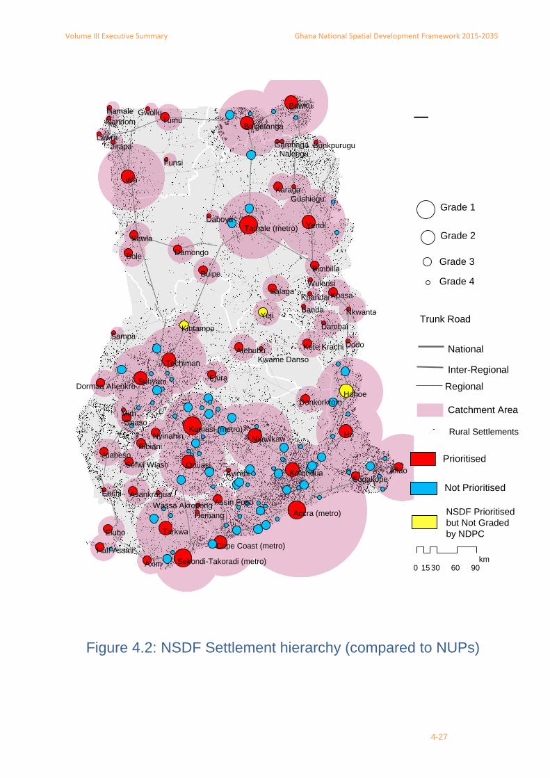
4.2.2 NSDF urban settlement hierarchy
The urban settlements hierarchy, with 70 urban settlements in four grades, has a combined area-of-influence that accounts for 90 percent of the national population, 95 percent of the urban population, and 80 percent of the rural population (Figure 4.2). There are 4 settlements at grade-1, 14 at grade-2, 31 at grade-3 and 21 at grade-4.
■ Four grade-1 settlements, Accra, Kumasi, Secondi-Takoradi and Tamale, are the largest cities in Ghana, have grown rapidly, and are regional capitals;
■ 14 grade-2 settlements include all twelve of the NUP grade-2 settlements, including the six regional capitals not in grade-1, plus Hohoe and Aflao, which fills gaps in the spatial coverage of grade-1 cities;
■ 31 grade-3 settlements include 25 NUP settlements while 38 NUP settlements are excluded because their areas-of-influence fall within the catchment areas of grades 1 and 2 settlements. Kintampo and Yeji, two settlements not graded by NUP, have sizable populations (over 25,000) and fill gaps in the coverage of the first two grades;
■ 21 grade-4 settlements include 21 NUP settlements that are outside the catchment area of the first three grades. The remaining 58 NUP grade-4 settlements are excluded because their spatial coverage does not significantly add to the catchment areas of the centres in grades 1, 2 and 3.
Table 4.1 shows the regional distribution of settlements by grade. In general, regions with larger settlements will have fewer in the hierarchy than those with smaller settlements.
Table 4.1 NSDF urban settlement hierarchy by region and grade
Gra
de
Gre
ate
r A
ccra
Ash
an
ti
Weste
rn
No
rth
ern
Up
pe
r E
ast
Cen
tral
Easte
rn
Up
pe
r W
est
Bro
ng
Ah
afo
Vo
lta
No
rth
ern
1 Accra Kumasi STMA Tamale Tamale
2
Tarkwa Yendi Bawku Cape Coast Koforidua Wa Sunyani Aflao Yendi
Obuasi Bolgatanga Nkawkaw Techiman Ho
Hohoe
3
Ejura Asankragua Bimbilla Assin Foso Donkorkrom Tumu Atebubu Dambai Bimbilla
Nyinahin Axim Bole Dormaa Ahenkro Kete Krachi Bole
Bibiani Buipe Goaso Kpasa Buipe
Elubo Damongo Kintampo Nkwanta Damongo
Half Assini Gushiegu Mim Sogakope Gushiegu
Juabeso Karaga Yeji Karaga
Sefwi Wiaso Salaga Salaga
Sawla Sawla
4
Enchi Bunkpurugu Hemang Ofoase Funsi Kwame Danso Banda Bunkpurugu
Wassa-Akropong Daboya Twifo Praso Gwollu Sampa Dodo Daboya
Gambaga Hamale Gambaga
Kpandai Jirapa Kpandai
Nalerigu Lawra Nalerigu
Wulensi Nandom Wulensi
Source: NSDF Study, 2014
Volume III Executive Summary Ghana National Spatial Development Framework 2015-2035
4-27
Grade 4
Grade 3
Grade 2
Grade 1
Rural Settlements
Catchment Area
Regional
Inter-Regional
National
0 30 60 90 15 km
¯
Ho
Wa
Mim
Yeji
Axim
Bole
Tumu
Dodo
Hohoe
Enchi
Ejura
Goaso
Sampa
Kpasa
Buipe
Sawla
Yendi
Bawku
Funsi
Lawra
Banda
Aflao
Elubo Tarkwa
Hemang
Obuasi
Dambai
Salaga
Daboya
Karaga
Nandom
Jirapa
Gwollu Hamale
Juabeso
Nkawkaw Bibiani
Atebubu
Nkwanta
Kpandai
Wulensi
Damongo
Gambaga
Sunyani
Ayirebi
Kintampo
Nyinahin
Techiman
Sogakope
Bimbilla
Gushiegu
Nalerigu
Koforidua
Asankragua Assin Foso
Donkorkrom
Bunkpurugu
Bolgatanga
Half Assini
Sefwi Wiaso
Kwame Danso
Kete Krachi
Accra (metro) Wassa Akropong
Dormaa Ahenkro
Kumasi (metro)
Tamale (metro)
Cape Coast (metro)
Sekondi-Takoradi (metro)
Trunk Road
NSDF Prioritised
but Not Graded
by NDPC
Prioritised
Not Prioritised
Figure 4.2: NSDF Settlement hierarchy (compared to NUPs)

Volume III Executive Summary Ghana National Spatial Development Framework 2015-2035
4-28
4.3 Abidjan-Accra-Lagos coastal megaregion or urban corridor
Ghana is part of a West African megaregion that spans 600 km across four countries—Côte d'Ivoire, Ghana, Benin, Togo and Nigeria. With a fast growing urban population of over 30 million, many experts consider this coastal urban corridor to be the engine of West Africa’s regional economy (Figure 4.3).
A mega-region, as defined by the Regional Plan Association and the Lincoln Institute of Land Policy, has a population density exceeding 77 p/km2 and projected population growth and job growth greater than 1.5 percent per annum. By itself, Ghana's coastal region already meets these criteria, with a total population of almost 11 million, an urban population of over 6 m, a density of 186 p/km2, and a total and urban population growth rate of 2.9 and 3.8 percent respectively. Added to this are the large and growing Nigerian cities: Lagos from 10.8 to 18.8 by 2020; Ibadan from 2.8 to 5 m, Ogbomosho from 1 to 1.8m, and Ilorin from 0.8 to 1.4 m.
The only planned region-wide interventions to date are the approved, though not yet aligned, Trans West Africa Highway and the proposed railway network along the coast. These projects will increase the region's attractiveness to economic development and with it more rapid population growth and urbanisation. This will only increase the need for a special corridor planning effort including a spatial development framework. Such a framework is needed to determine, for example, how the urban areas can become more spatially connected and functionally bound, but also how they might maintain distinct spatial entities separated by green infrastructure with natural landscapes worthy of protection, and how intercity travel and freight movement can be best manage over roads, high-speed rail and new air links.

Volume III Executive Summary Ghana National Spatial Development Framework 2015-2035
4-29
population in 2025
10,000,000
7,500,000
5,000,000
2,500,000
1,000,000
Figure 4.3 Abidjan-Accra-Lagos coastal megaregion

Volume III Executive Summary Ghana National Spatial Development Framework 2015-2035
4-30
4.4 Two city-regions around Accra and Kumasi
Ghana has two major city-regions that are centred around Accra and Kumasi. These two city regions have physically over-spilled their administrative boundaries into adjacent areas that include district, municipal and metropolitan assemblies. They have engulfed smaller cities and towns and absorbed semi-urban and rural hinterlands. They have dense urban cores and a sizeable number of other urban settlements within a reasonable commute distance. Moreover, both are among the faster growing urban areas in Ghana.
4.4.1 Accra City-Region
The Accra city-region (ACR) may be variously defined as: (i) the area described as the Greater Accra Metropolitan Area, or GAMA, in 1991, (ii) the 90 km2 contiguous built-up area in 2010, (iii) the districts sharing part of the built-up area, or (iv) the present and future daily commuting zone. (See Figure 4.4).
ACR, as defined by the 439 km2 area of the twelve districts2 that contain part of the Accra contiguous built-up area, has a population of 4.3 million, 4 million urban and 400,000 rural, an urbanisation level of 90 percent; its population and urban population grew at 3.54 and 3.92 percent annually between 2000 and 2010.
ACR accounts for about 25 percent of the national GDP. It leads or is second in almost all non-primary sectors except education. As the governmental and commercial capital of the nation, ACR acts as a magnet for investment into the country and as a gateway for international trade. It is roughly at the centre of a West African regional economic corridor—and inter-connected by good air, sea, rail and highway links—running from Abidjan to Lagos, an economic powerhouse. It also has attractive beaches, room for physical expansion, and is close to the country's main power source.
Recent developments in ACR include the Airport City and several highways. Planned projects include a ring-road, the Trans-African Highway and a regional rail network, and Tema port improvements. Other opportunities for investment include water front development and additional multi-storey development, particularly near the airport.
Key challenges
Key challenges facing Accra include its rapid expansion at declining densities and strengthening Accra as a gateway to international trade.
Between 1985 and 2000, Accra's overall density decreased at the annual rate of 3.2 percent and between 2000 and 2010 it decreased at 5.8 percent per annum. This rapid expansion at declining density raises questions as to how Accra's projected population could be contained. Assuming that the planning objective is to contain the population within the outer-ring road (which at 1800 km2 is twice the existing 900 km2 built-up area, NSDF determines that there will be need to plan for and encourage higher density development.
2 These twelve districts are year-2010 districts, located in three regions. Nine are in the Greater Accra Regions: Accra
Metropolitan Area (AMA), Tema, Ledzokuku Krowor, Adentan, Ashaiman, Ga East, Ga West, Ga South, and Dangme West.
One is in the Eastern Region: Akwapim South. Two are in Central region: Awutu Senya and Gamoa East. Of these districts,
AMA and Tema are metropolitan assemblies while Ashaiman, Ga West, Ga East and Ledzokuku Krowor and Akwapim South
are all municipal assemblies.

Volume III Executive Summary Ghana National Spatial Development Framework 2015-2035
31
Figure 4.4 Accra City-Region
Volume III Executive Summary Ghana National Spatial Development Framework 2015-2035
32
NSDF recommends the following strategic actions to strengthen Accra as a gateway: (i) support Accra to compete globally, especially with regional centres such as Lagos and Abidjan, to attract investment in activities associated with the role of a regional business, trade and investment hub—a role that no other city can play; (ii) improve connectivity to international markets through new and upgraded air, rail, expressway and marine infrastructure; and (iii) avoid shifting industry and services from Accra to secondary cities and let these cities grow naturally, in a mutually-beneficial way.
4.4.2 Greater Kumasi Sub-Region (GKSR) and Greater Kumasi Conurbation
The Kumasi city-region (KCR) may be taken as the "Greater Kumasi Sub-Region", or GKSR, which was delineated by the "Study on the Comprehensive Development Plan for Greater Kumasi". It has eight districts, or an area of 2,850 km2, equivalent to 11 percent of Ashanti region area. Within GKSR, the "Greater Kumasi Conurbation", or GKC, GKC covers 1,025 km2 or about 4 percent of Ashanti and about 36 percent of GKSR, as well as GKC; Kumasi Metropolitan Assembly (KMA) covers 254 km2 or about 25 percent of GKC. (See Figure 4.5).
Kumasi, Ghana’s second largest city, has a population size and growth that may qualify it as a primary city along with Accra. It is the centre of national population distribution and a hub of transportation between the south and the north. It sits at the peak of the ‘golden triangle’, links the coastal industrial corridor with the rest of the country, and links the cocoa producing regions with the ports of Tema and Takoradi.
Significant economic growth has been achieved largely through promotion of labour-intensive industries and the ICT and high-tech sectors. With the nickname “The Heart of the Nation; a City of Culture and Knowledge" and a long and rich history, the Kumasi City-Region has consolidated its position as the commercial and agricultural service centre for the central zone of Ghana. It is also an academic centre and has several significant manufacturing clusters, Suame Magazine being the most known.
Key challenges
Key challenge facing Kumasi city region is planning for the rapid, concentrated population growth resulting in very high densities in the core.
According to GKUDP, Ashanti's population may increase from 4.8 to 8.7 million between 2010 and 2033, GKSR's from 2.8 to 5.8 million, GKC's from 2.5 to 5.5 million, and KMA/Asokore Mampong's from 2 to 4.2 million, or almost half of Ashanti's population3. Thus population may concentrate, with the area outside GKSR growing slower than GKSR, its area outside GKC growing slower than GKC, and the population outside GKC but within GKSR falling to about 300,000. Although GKC is planned to de-concentrate, its area outside of KMA/Ashokore Mampong may grow more rapidly than within KMA/Asokore Mampong, nearly tripling from 0.42 to 1.24 million inhabitants by 2033. As residential land may increase slower than the population, residential densities may increase from 67 to 73 persons per hectare in GKC and from 159 to 279 ppha in KMA/Asokore Mampong, a density that is comparable to some of the most densely populated cities in the world.
3 GKUDP, 2013

Volume III Executive Summary Ghana National Spatial Development Framework 2015-2035
33
Figure 4.5 Kumasi City-Region

Volume III Executive Summary Ghana National Spatial Development Framework 2015-2035
4-34
4.4.3 Recommendations for city regions
The two city-regions have a number of common challenges that may invite common strategies. These include: rapid, low density expansion at peripheries and in towns and villages that are up to 100 kilometres from the centres; ribbon development along feeder and trunk roads, and in cluster patterns that lack basic services and social amenities; as well as lack of affordable housing. NSDF recommends the following measures to address these challenges: adopt city-region planning and management including city-region spatial development frameworks; promote regional accessibility; discourage scattered development; establish urban growth containment boundaries; provide ring roads where applicable; establish and strengthen development corridors; promote "centrality", or the share of the population that lives close to the city centre compared to its suburbs and periphery; . promote "centeredness", or the share of jobs and other attractions located in the main activity centres; promote high densities; promote "compactness", or the degree to which a city footprint approaches that of a circle; strengthen the central business district; invest in other urban centres; promote transport-oriented-development, or TODs; promote mixed land uses; promote public transport; discourage private vehicle use; promote alternative transport modes; promote physically connective road networks; manage traffic before building new roads; promote digital connectivity; and adopt a grid-based model for urban expansion.
4.5 Urban Networks4
Urban networks may be defined as a spatial form comprising cities, towns and rural settlements that are within a reasonable distance of each other5. Given the success of a spatial development strategy that supports urban networks in other countries, NSDF advocates such an approach in Ghana. While population and economic activities are likely to continue to concentrate in and near the largest metropolitan areas, the intensity of this development may be balanced by promoting growth in urban networks around regional cities.
Urban networks have many potential benefits. These include realisation of urban synergies and more inclusive development; more efficient and affordable services; more diverse job and housing opportunities; stronger attractiveness for investment; improved capacity to solve urban problems; concentrated and balanced urban development; reduced out-migration and improved functional links.
Implementation of urban networks may not require a new tier of government but could be managed through voluntary, flexible and pragmatic partnerships between local- and district-level authorities.
NSDF proposes that the government create and support an association of urban networks with the aim of sharing learning and best practices. Initially, priority attention will have to be afforded the networks that are most keen to be established. After progress can be demonstrated, attention should be given to the networks in the most disadvantaged areas.
4 NSDF uses the term "urban network" although other terms such as "urban cluster" and "urban zones" are used in the literature and have the same or similar meanings.
5 What constitutes a "reasonable" is a subjective matter that depends not only on transport modes and time-distance but also on individual perceptions. This suggests that reasonableness should be established empirically by asking people directly.

Volume III Executive Summary Ghana National Spatial Development Framework 2015-2035
4-35
NSDF identifies eight urban networks (Table 4.2)—around STMA, Tamale, Cape Coast, Sunyani, North-East (Bolgatanga-Bawku), Aflao, Ho-Hohoe and Wa—based on the following criteria: (i) a maximum distance of 100 km between the most distant urban settlements; (ii) the presence of a regional capital6; (iii) the presence of at least one grade 1 or grade 2 urban centre; (iv) at least one settlement on the proposed rail network and connected to the proposed expressway system; and (v) possessing a higher than average rural population density.
Table 4.2 City Region and Network Metrics
Note: Population given in '000
Source: NSDF Study based on data from GSS and the Forestry Department Satellite Imagery
In reversed order by 2010 population, these urban networks are as follows:
Sunyani Urban Network (SUN): SUN includes about 60 urban and rural settlements (Figure 4.6). Its population grew from 1.2 m in 2000 to 1.6 m in 2010 and may grow to over 2.3 million by 2035. Its population is already clustered in sizeable urban areas that are relatively close to each other. SUN is a relatively fast growing area. By 2035 it may have 20 towns with populations above 20,000. SUN has national importance for: (i) providing an urban growth alternative to the four large cities, (ii) being the centre of high-value, high-output agricultural production, and (iii) having Techiman as an important market hub and one of the fastest growing urban centres.
North-East Urban Network (NUN): NEUN, comprising all of Upper East region and the north-eastern part of Northern region, is one of relatively high urban and rural population density, with 21 urban centres: 11 in Upper East region and 10 in Northern region (Figure 4.7). Its population grew from 1.0 m in 2000 to 1.2 m in 2010 and may grow to over 1.9 million by 2035. Three mini-urban networks may be identified within NUN: Bolgatanga, Bawku, Walewale and Gambaga.
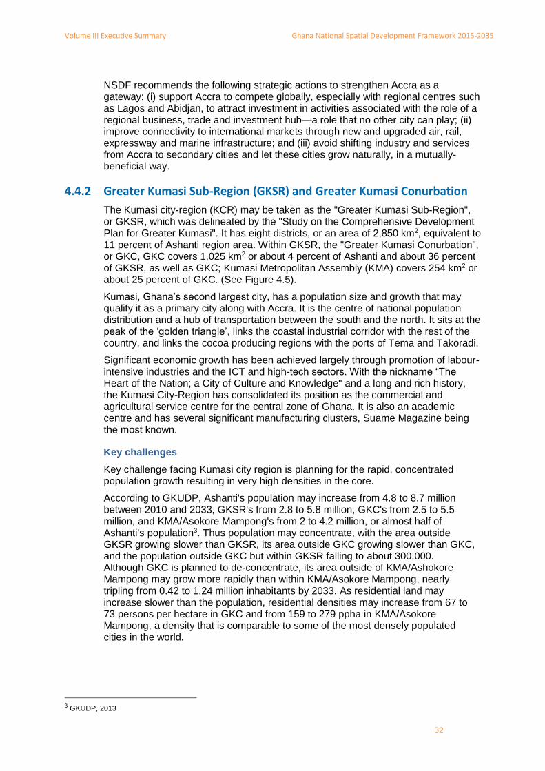
Aflao Urban Network (AUN): AUN, with 22 urban settlements, grew from 0.7 m in 2000 to 0.9 m in 2010 and may reach 1.1 m by 2035 (Figure 4.8). It has two mini-
6 Except in the case of Alfao.
net
wo
rk a
rea
(km
2)
tota
l po
pu
lati
on
rura
l po
pu
lati
on
urb
an
urb
anis
atio
n le
vel
net
wo
rk d
ensi
ty p
/km
2
tota
l po
pu
lati
on
rura
l po
pu
lati
on
urb
an
urb
anis
atio
n le
vel
net
wo
rk d
ensi
ty p
/km
2
tota
l po
pu
lati
on
rura
l po
pu
lati
on
urb
an
Accra City Region 9,840 5,847 1,196 4,651 80 594 11,127 676 10,450 94 1,131 2.61 -2.25 3.29
Kumasi City Region 11,108 4,023 1,266 2,756 69 362 7,797 1,029 6,768 87 702 2.68 -0.83 3.66
Sunyani Network 15,496 1,625 828 796 49 105 2,374 611 1,763 74 153 1.53 -1.21 3.23
North-East Network 10,876 1,263 955 308 24 116 1,907 1,002 905 47 175 1.66 0.19 4.41
Aflao Network 5,449 890 597 293 33 163 1,136 503 633 56 208 0.98 -0.68 3.13
Ho-Hohoe Network 4,884 835 499 336 40 171 1,622 261 1,360 84 332 2.69 -2.56 5.76
STMA Network 905 752 120 632 84 831 1,896 500 1,397 74 2,096 3.77 5.86 3.22
Tamale Network 4,169 626 301 325 52 150 859 283 577 67 206 1.28 -0.25 2.32
Wa Network 9,027 598 494 104 17 66 881 749 133 15 98 1.56 1.68 0.97
Cape Coast Network 1,005 558 238 321 57 555 766 206 560 73 762 1.27 -0.56 2.25
Total in Networks 72,759 17,016 6,495 10,521 62 234 30,366 5,820 24,546 81 417 2.34 -0.44 3.45
Pop outside networks 154,774 7,643 5,613 2,030 27 49 11,325 5,680 5,645 50 73 1.59 0.05 4.18
TOTAL 227,533 24,659 12,107 12,551 51 108 41,690 11,500 30,191 28 183 2.12 -0.21 3.57
% population in networks 69 54 84 73 51 81
2010 2035 Pop growth rate

Volume III Executive Summary Ghana National Spatial Development Framework 2015-2035
4-36
clusters: Aflao, Dzodze and Akatsi, with a combined population of 90,000 in 2010 and Mete and Sogakope with a combined population of 37,000.
Ho-Hohoe Urban Network (HHUN): HHUN, with 18 urban settlements, grew from 0.6 m in 2000 to 0.8 m in 2010 and may grow to 1.6 m in 2035 (Figure 4.9). HHUN's largest town is Ho, the Volta regional capital with 112,000 inhabitants, followed by Hohoe with 74,000. Peki Avetile and Tsito, with a combined population of 20,000, are sufficiently close by, to form a mini-cluster.
Sekondi-Takoradi Urban Network (STUN): STUN, with six urban settlements, grew from 0.4 in 2000 to 0.7 m in 2010 and may reach 1.9 m by 2035 (Figure 4.10). STUN is 84 percent urbanised and is one of the more populous urban networks.
Tamale Urban Network (TUN): TUN, with five urban settlements, grew from 0.5 m to 0.6 m and may reach 0.8 m by 2035 (Figure 4.11). TUN's urbanisation level may increase from 52 to 67 percent by 2035.
Wa Urban Network (WUN): WUN, with six urban settlements, grew from 0.5 in 2000 to 0.8 m in 2010 and may exceed 0.8 m by 2035 (Figure 4.12). Four of WUN's urban settlements are relatively close to one another. Even though it is the regional capital, Wa may be too distant from the others and growing too slowly to function as WUN's core; a possible location for a centre may be at the intersection of the north and south trunk roads about 16 km east of Lawra.
Cape Coast Urban Network (CCUN): CCUN, with 13 urban settlements, grew from 0.4 in 2000 to 0.5 m in 2010 and may exceed 0.7 m by 2035 (Figure 4.13). While it is a distinct urban network owing to the presence of the regional capital surrounded by a sizeable number of urban and rural settlements, all or part of CCUN may also be considered as belonging to the STUN, only 60 km away.

Volume III Executive Summary Ghana National Spatial Development Framework 2015-2035
4-37
Figure 4.6 Sunyani Urban Network

Volume III Executive Summary Ghana National Spatial Development Framework 2015-2035
4-38
Figure 4.7 North-East Urban Network
Volume III Executive Summary Ghana National Spatial Development Framework 2015-2035
4-39
Figure 4.8 Aflao Urban Network

Volume III Executive Summary Ghana National Spatial Development Framework 2015-2035
4-40
Figure 4.9 Ho-Hohoe Urban Network

Volume III Executive Summary Ghana National Spatial Development Framework 2015-2035
4-41
Figure 4.10 STMA Urban Network

Volume III Executive Summary Ghana National Spatial Development Framework 2015-2035
4-42
Figure 4.11 Tamale Urban Network

Volume III Executive Summary Ghana National Spatial Development Framework 2015-2035
4-43
Figure 4.12 Wa Urban Network

Volume III Executive Summary Ghana National Spatial Development Framework 2015-2035
4-44
Figure 4.13 Cape Coast Urban Network
Volume III Executive Summary Ghana National Spatial Development Framework 2015-2035
5-45
5 Important National Initiatives
NSDF proposes several national initiatives that support the spatial development pillars noted above. These are: a national and international expressway system, upgraded trunk roads, national and international rail network, two international airports, a new airport city, a green infrastructure network, three new seaports, an agricultural growth corridor, urban foodsheds and alternative energy projects.
5.1 A national and international expressway system
Need for and benefits of a national expressway system: Ghana's trunk road system connects almost all urban centres but suffers from several deficiencies. To meet the growing demand for mobility and connectivity, many countries have introduced a controlled-access, multi-lane, divided expressway system that is separate from their trunk road systems. Evidence from many developed countries and USA suggests that an expressway system can improve economic efficiency and productivity, reduce freight cost, expand markets, lower prices and increase selection, encourage business expansion and create jobs.
Components of NSDF proposed expressway system: NSDF proposes a national expressway system that includes upgraded trunk roads and highways and new segments. The upgraded highways include the two Trans-African Highways (TAH) that run along the coast and north-south. These expressways will connect to national transport centres and the future intermodal transport system that includes rail, air and ferry. The four new expressway segments are:
■ Accra–Kumasi expressway;
■ Kumasi–Paga expressway;
■ The Sunyani loop (Techiman–Sunyani–Kumasi);
■ An upgrade of the TAH 7, Trans–West African Coastal Road.
Accra–Kumasi expressway: Ghana Highways Authority (GHA) is planning a new Accra–Kumasi link that runs parallel to the existing Accra–Kumasi national trunk road (N1)7. NSDF proposes an improved alignment that would be eight percent shorter and run through the centre of the triangle, strengthening the centre as a potential site for a new airport (Section 5.4) and new city (Sections 5.5). A car journey from the triangle's centre to each city, about 110 km in length, would take about one hour and an intercity train about 40 minutes.
Kumasi–Paga expressway: The Kumasi–Paga segment would complete the central, north-south expressway and connect the port cities of Accra–Tema and STMA to Kumasi, Techiman, Tamale, Bolgatanga and on to Ouagadougou, Bamako and Niamey. The expressway would also support development in these cities and expedite transport of agricultural produce to the major markets. Where suitable, the existing highway or truck road would be upgraded into an expressway.
The Sunyani loop: The Sunyani loop has two-segments: (i) one that connects Kumasi to Sunyani, Berekum, Dormaa—all part of the Sunyani Urban Network—and eastward to Cote d'Ivoire; (ii) the other from Sunyani to Techiman. The loop reduces travel time between Sunyani and Kumasi to between 60 and 80 minutes, an
7 Ghana Highways Department, October 2014.

Volume III Executive Summary Ghana National Spatial Development Framework 2015-2035
5-46
acceptable commute time, it strengthens the Sunyani Urban Network, and links to important urban centres in Côte d'Ivoire.
Accra city-region expressway system: This system, which would support and help to concentration of the expected urban development, would consist of four radials from and three rings around Accra and link to Secondi-Takoradi, Cape Coast and two outer ring roads around Kumasi. The system also links the two sea ports to Boankra inland port.
ECOWAS Trans–West African coastal expressway: ECOWAS is planning the Trans-West African coastal highway to connect Africa's largest megapolitan area comprising the coastal cities of Côte d'Ivoire, Ghana, Togo, Benin and Nigeria8. NSDF proposes a second east-west expressway that would parallel the planned, ECOWAS coastal railway line through the centre of the triangle and on to Dunkwa and Asankrangwa.
5.2 Upgraded and improved trunk roads
There is a need to improve the trunk roads in the SADA zone, around Lake Volta, and in Western and Volta regions.
Improve SADA trunk road system: Proposed road improvements are: (i) new inter-regional road between Wa and Tamale; (ii) new and upgraded inter-regional road between Wa and Bolgatanga; (iii) new segment of national trunk road between Bimbila and Tamale; (iv) upgraded trunk road Yendi–Bawku as an alternative to the central corridor route; (v) upgraded trunk road on the N-11 between Bolgatanga and Bawku; upgraded regional road on the I-11 between Nakpanduri and Walewale; and (vii) improved connection between Gushiego, Karaga and Tamale.
Improve connectivity around and across Lake Volta: Lake Volta acts as a barrier between Volta region and the central corridor, this barrier can be reduced through the following interventions: (i) strengthen the Kumasi, Ejura, Atebubu connection to Yeji and Kwadwokurom; (ii) improve service on the Yeji and Kwadwokurom ferries; (iii) improve roads around and close to the lake; (iv) move Dambai ferry crossing to Kpetchu to reduce east-west travel time; (v) develop a new road and ferry crossing from the northern part of Eastern region, to Dominase–Koforidua. These interventions will support residential and tourism development around the lake, unleash agricultural potential and provide, as an alternative to the coast, an east-west route between West African countries.
Improve connectivity in Western region: NSDF proposes to improve six road segments in Western region which would promote interaction between urban centres, improve access to agricultural areas, and improve links to Takoradi. Another proposed improvement is along the western border from Adwufia in the south towards the north to New Drobo and from Sampa to Banda just south of the Bui Dam.
Improve the Ho-Akanu border crossing: NSDF proposes to improve this connection along the R10 to better link Ho to Lomé, only 106 km away, which provides a sizeable market for produce from Volta region and development of trade.
5.3 A national and international rail network
The benefits of railroads: Railways are efficient because they concentrate people and goods and transport them over a fixed route using one engine and multiple rail
8 http://www.theatlantic.com/international/archive/2013/07/how-africas-new-urban-centers-are-shifting-its-old-colonial-boundaries/277425/
Volume III Executive Summary Ghana National Spatial Development Framework 2015-2035
5-47
cars. Efficiency translates into low transport costs which improves the competitive positions of shippers and producers, impacting the cost of end users. Similarly, rail transport increases labour mobility and facilitates economic development outward from urban centres. Finally, railways are 'green' because they require less land than highways, alleviate road congestion, reduce road maintenance costs and reduce road deaths and injuries.
NSDF proposed railroad network: NSDF proposes refinements to the railway plans prepared by the Ghana Railway Master Plan project and the draft NIP (Figure 5.1). NSDF's network length, double NIP's and 30 percent more than GRMP's, includes the existing railway, modernised and realigned, a new Kumasi–Paga segment, new links to the inland water transport system on Lake Volta, links to Togo and several new links in the dense and urbanised south. The NSDF proposed new links comprise the following:
■ a modern, high-speed line between Accra and Kumasi through the centre of the triangle with links to Cape Coast and Takoradi, Bolgatanga and Bawku and on the ECOWAS railway system at Ghana's border with Togo and Burkina Faso;
■ links to the cities in neighbouring countries including Korhogo in Côte d'Ivoire and Ito Zabzugu, Kara and Sokode in Togo;
■ new alignment of the proposed ECOWAS coastal railway line from the centre of the "triangle” to the Côte d'Ivoire border;
■ links to areas with significant mineral deposits.
5.4 Two international airports
Balancing competition with equitable access: The Government wants its international airport services to be competitive with those of its neighbours in West Africa—it envisages Ghana as a regional aviation hub. However, this requires a high quality international airport standards that are costly to construct, operate and maintain. Construction costs alone are known to reach over USD 1.4 billion. At least four locations are or have been considered as possible international airport sites: KIA (operating), Tamale (being developed), Kumasi (proposed in the Greater Kumasi Sub-Regional SDF) and Prampram, near Accra (proposed funding by China Airport Civil Construction). NSDF questions whether Ghana needs and can afford four international airports and whether international carriers will service multiple airports.
Two international airports in north and south: Given the high airport costs and principle of balanced development and Ghana's shape (a vertical rectangle with height about double the width), NSDF proposes only two international airports in the framework period: one in the northern half (Tamale) and the other in the southern half, either at Prampram or preferably at the centre of the triangle. While the Prampram site is close to the nation's capital, the centre of the “triangle” presents a viable and perhaps best option. It is more central and, with railway and expressway, easily accessible from all three triangle cities. The Accra and Kumasi airports could then be used for national flights9.
5.5 New Airport City at Centre of Triangle
NSDF proposes a new airport city at the centre of the triangle, accessible to the country's largest and densest urban populations. With the three proposed national initiatives—airport, expressway, rail network—the location meets the criteria for new-
9 In Europe, national flights less than 400 km are being substituted by railway journeys, which are considered cheaper, less time consuming
and more environmental friendly.

Volume III Executive Summary Ghana National Spatial Development Framework 2015-2035
5-48
city success: rapid and high quality transport links to Accra, Kumasi and Takoradi; sufficiently distant to remain independent from these centres; and sufficient land for greenfield development.
A new city would provide important benefits. Amongst other it would: (i) promote greater interaction between and strengthen the competiveness of the 'triangle' cities in the West African context; (ii) provide a model for sustainable urban development and management; (iii) attract manufacturing and high-tech firms and high-calibre personnel that might have otherwise located and migrated to large cities; further (vi) it would be planned to accommodate current and future facilities as relates to storage, cooling, ICT, security, energy efficiency and waste treatment, amongst other.
With an airport city, Ghana would join a growing list of over 80 countries that have or are planning airport cities10. New airports are no longer single function facilities, they have become multimodal, multi-functional enterprises that generate considerable commercial development around and beyond their sites.
5.6 Options for three new seaports
Given that Tema and Takoradi ports are physically constrained and that demand for port facilities is increasing, NSDF identifies and proposes three areas for possible port expansion (Figure 5.2). All three are near to deep water, close to existing ports, relatively free of urban development and easily connected to the future West African coastal highway and railway. Two areas are located east of the Tema port: one at Akaplabanya, 68 km from Tema, the other at Adina, close to the Togo border. Akaplabanya, near to the lower Volta River and Akosombo inland port, could be connected to the inland water transport system by either rail or canal. The third area at Cape Three Points, 37 km to the west of Takoradi, is well-located for the oil and gas industry.
5.7 Green infrastructure Network
Need for and benefit of Green Infrastructure Network (GIN): A green infrastructure network of green places and water systems delivers multiple environmental, social and economic values and services to urban and rural communities. It is simultaneously an ecological network, a wildlife corridor, a river buffering system, an enhanced forest reserve network, a recreational asset and a visual amenity. GINs provide a counterpoint to urban development and anchor the urban centres while at the same time protect and help restore natural systems and open spaces that serve as an environmental system for and between urban settlements.
NSDF proposed green infrastructure network: NSDF's GIN concept incorporates all protected areas, buffers along the coastline, main rivers and lakes, and new connectors between these elements using green corridors along existing and new roads and railroads (Figure 5.3). The protected areas include over 260 forest reserves, national parks, wildlife sanctuaries and wetlands sites. All main river segments, Lake Volta and other lakes and the coast will be buffered and will serve to link most of the protected areas and connect to most urban settlements. Nevertheless, where there are no natural links, a new "green link" will be required. In addition, a cattle drive corridor can be designated to mitigate the conflict with farmers.
10 http://www.aerotropolis.com/files/AirportCities_TheEvolution.pdf

Volume III Executive Summary Ghana National Spatial Development Framework 2015-2035
5-49
GIN implementation must be led by the public sector, but its success will depend on strong partners in the private and civil society sectors. Regional, district and local authorities will need to prioritize green infrastructure in their SDFs, structure and local plans. Sectoral agencies, especially the Forest Commission, MOFA, GRIDA, VRA, GHA and Ministry of Water, Works and Housing will have a role to play in planning and maintaining the GIN.
5.8 Agricultural Growth Corridor
The Agricultural Growth Corridor (AGC) concept, developed by the World Economic Forum in 2009, is aimed at regions with subsistence agriculture practices and with unrealised agricultural potential. The theory is that targeted provision of strategic infrastructure—roads, railways, irrigation, storage, processing and ports—will attract investment and facilitate commercial agriculture development. Key requirements for an AGC include: (i) availability of large land areas for industrial agriculture; (ii) established infrastructure such as roads, irrigation, and warehouses; (iii) links to ports and other countries; (iv) strong private sector involvement; (v) accessibility to large urban markets and (vi) small-holder farmers.
African countries with successful AGCs include Tanzania (Southern Agricultural Growth Corridor) and Mozambique (Biera Agricultural Growth Corridor, Nacala Corridor, and Zambesi Corridors); Nigeria is developing a AGC with support from USAID.
Ghana has the preconditions to establish an AGC as follows: (i) a central, national-level trunk road from Accra to Bolgatanga that connects high production areas to ports, international borders and major urban markets; (ii) institutions with similar agricultural projects such as GADCO, AgDevCO, SADA and Feed the Future; and (iii) major markets for to buy and supply agriculture outputs and inputs.
NSDF provides two options for an AGC although there are several other possibilities (5.4). Option 1 comprises the area within 50 km of the central trunk road, while option 2 comprises the districts that are located next to the trunk road.
5.9 Proposed urban food sheds
Urban populations are growing and expanding, often consuming high value farm land. This means that cities need to feed more people on less land or land that is further away. To address this trend, NSDF promotes the concept of "foodsheds". A food shed refers to the farms, processing facilities and distribution networks within a certain distance to a city that sustain the flow of fresh food to nearby populations. The benefits of a food shed are the following: (i) food grown nearby reduces transportation costs, energy, and potential disruptions; (ii) locally produced food is more nutritious; fruits and vegetables lose 40 percent of their nutritional value within three days of being harvested; (iii) the greater access to fresh produce, the less likely we are to suffer from diet-related illnesses such as obesity and diabetes. NSDF has identified the cities where food shed planning is a priority. For example, within a radius of 50 km, Accra and Kumasi have 15 and 13 persons per hectare of cropland, respectively, while Cape Coast and Tamale have only 2 and 1 respectively. When the food shed radius is increased to 70 km, Accra's ratio falls to 5 and Kumasi's to 3 persons per crop hectare.
5.10 Alternative Energy Projects
Today energy is mostly produced through hydropower and thermal plants driven by fossil fuels. There are three alternative energy sources that have potential to

Volume III Executive Summary Ghana National Spatial Development Framework 2015-2035
5-50
supplement fossil fuel and hydropower generation: biomass, solid waste, and solar, and wind.
Biomass: Buipe and Tamale provide attractive locations for new biomass energy plants. They are on or near several transport corridors that enable efficient transport of wood and crop residues from the northern regions as well as from Brong Ahafo and Volta. Biomass energy plants can complement national energy production but must be located at close areas with production of sufficient amounts of biomass.
Solid waste power plant: The area between Kumasi and Accra, including the triangle, provides an attractive area for a modern solid waste power plant, provided a link is developed between them. These two large urban areas generate large amounts of solid waste fuel, industrial wastes, and medical wastes.
Solar and wind energy: The northern regions have high potential for solar energy production. VRA has already established a plant in Navrongo. Tamale provides a good site for a solar energy power centre that would include solar energy generation, education and practical training. There are areas on the coastal belt if supplied with low speed wind turbines some wind farms can be established.
Volume III Executive Summary Ghana National Spatial Development Framework 2015-2035
6-51
6 NSDF phasing and cost estimates
6.1 Introduction
Regarding Implementation and Phasing of the Ghana National Spatial Development Framework, reference is made to Chapters 5 and 6 in particular of Volume II Overall Spatial Development Strategy, for a listing of the priorities and cost estimates of some of the key elements proposed by NSDF initiatives, as well as other ongoing Government of Ghana initiatives and plans.
This section presents an implementation schedule for the establishment of new urban areas and infrastructure and project preparation as well as the implementation cost estimates to meet the future development challenges.
The implementation schedule considers existing and proposed development projects and includes infrastructure projects proposed by the NSDF. Finally the section presents some consideration on the relation between the need for investment in infrastructure and the expected economic resources available for the generation of the Ghana GDP during the plan period. Some proposed transport projects planned in the NSDF are not included in the implementation time schedule for the plan period 2016 - 2035, as they are considered to be implemented well beyond 2035. However, the areas and cost estimates of needed land and project preparation have been included.
6.2 Phasing and population growth
The phasing and cost estimates of the NSDF, consider the demands created by the expected population growth and urbanisation in Ghana, as well as infrastructure planned by the sector ministries and the draft NIP. These have been reviewed and improved and new infrastructure could hence be proposed by the NSDF. The cost estimates have been partly taken from the draft NIP and partly collected from similar types of projects in Africa and other developing countries. Cost calculation of basic urban infrastructure needed for new urban areas such as roads, water, environmental sanitation and electricity have been included while the cost for housing, education and health infrastructure are not included.
NSDF has adopted the high figure of 42 million for the national population by 2035, with an average annual population growth rate of 2.19 percent over the period 2010 to 2035.
NSDF uses the figure of 72 percent as the anticipated urbanisation level in 2035, which results in an urban population of about 30 million when applied to the high population variant of 42 million. Ghana population will grow considerably and the growth and the rural – urban migration might increase the population in urban settlements with up to 17.5 million new citizens.
This development will increase demand for basic infrastructure drastically, wherefore the need for improved and efficient land use planning and development control within a strengthened institutional and legislative framework.
6.3 Future distribution of population in Ghana
An average population growth rate has been calculated and used to distribute the population growth in the 4 sub-periods of the 20 year NSDF.

Volume III Executive Summary Ghana National Spatial Development Framework 2015-2035
6-52
NSDF has also calculated the demand for land for new urban areas. In low dense areas the existing land area might be used more efficiently avoiding the need to sprawl on new land. NSDF also projected the need for residential land and the cost to prepare the service infrastructure; (Figure 6.3) in Volume II Overall Spatial Development Strategy.
Population growth and distribution in settlements
The population growth is distributed over the settlements with over 50.000 inhabitants in 2010 and in the other urban settlements and grouped by region. The NSDF also considers the establishment of a new town with 500.000 inhabitants in the “triangle area”. The need for urban area has been calculated per inhabitant standards and the area required for development has been distributed accordingly. The projection shows that Ghana will need to develop around 54,100 ha of new urban land of which 40.1% (21,700 ha) will be needed for residential areas to cater for the population growth between 2016 and 35. This will require thorough considerations for sufficient viable low-cost, affordable housing, residential land for development.
The regional and local government can use the NSDF projections to consider how and where to prepare these new urban areas to accommodate the future population.
NSDF has prepared an implementation schedule (Figure 6.1) where all existing development plans prepared by the sector ministries and the draft NIP have been located according to their implementation periods. The majority is scheduled to take place within the NSDF plan period 2016 -20, but some projects, such as the water and sanitation plan runs through the plan periods 2016 - 25.
NSDF proposed infrastructure project has been distributed having in mind the existing projects and their costs and their priorities. NSDF proposes three new power plants, but plans the implementation later in the NSDF planning period, hence, coordinating with the development of transport infrastructure.
NSDF has given priority to the proposed improvement of the existing roads and plans construction of new roads in later phases of the plan period. Expressways have been planned for implementation in the end of the plan period. However the planning of the alignments and the acquisition of land have been planned to take place as a continuous process all through the plan period.
On the other hand, NSDF gives priority to the renovation of the existing railways and the construction of a new railway between Tema and Boankra Accra. Another similar priority is given to the development and improvement of the inland water transport.
Concerning the implementation plan for the development of new urban areas, this development has been planned to follow the projected population growth. The implementation of the New Town has been planned to start in 2025, but the planning of the new urban area and the acquisition of land will start earlier. The planning will also include the location of an area for an eventual development of a new international airport and for a modern solid waste treatment and power generation plant as well as the alignments for the railways and expressways.
The general development of the water and ITC sector projects are planned to be implemented continuously throughout in tandem with the natural protection and climate change mitigation plans along rivers and water body banks.

Volume III Executive Summary Ghana National Spatial Development Framework 2015-2035
6-53
Figure 6.1 Implementation and cost plan in Volume II, presents the NSDF implementation and cost plan. It has been divided into 4 sub plan periods of 5 years each, running from 2016 to 2035. The plan includes projects from the important infrastructure sectors and focuses also on the need for the preparation of new urban development areas. The implementation plan in total includes development projects at a cost estimate of 268 Bn US$ equivalent to an average of 13.4 Bn US$ per year. The projected GDP for the period is 2,379 Bn US$ with an average of 119 Bn US$ per year. The cost of NSDF implementation plan and the distribution of identified development projects have been compared to WB considerations on suitable priorities according to the development needs.
6.4 Evaluation of needed resources for infrastructure development
NSDF has evaluated the availability of funds for new and improved infrastructure in Ghana in the period 2016 to 2035. For the projection of the Ghana GDP, NSDF has used the growth rates suggested for the development of the economic development made by IMF 2014. The projected GDP is shown in Figure 6.1 below.
Figure 6.1 Projected GDP development in Ghana 2105 to 35
According to the World Bank's AICD Projects, Ghana would have a need for investment in infrastructure at a level of 12.5% - 21.5% of the GDP per year respectively. Maintenance and running cost would occupy around 3% to 5.5% of these investments. The public sector is advised to cover only between 3% and 5.75 of the investments, while the private sector and donors should finance the remaining needs.
NSDF has compared the NSDF planned implementation cost estimates, including the projected expenditures for development projects in the draft NIP, with the proposed guidelines from the WB AICD project. In the plan period 2016-20 the planned expenditures are 9.5 % of the GDP in this period. This budget is the proposed level by WB AICD project but over the public level of 5%, which means that the private sector must have an important role to play to complement the public investments. In case this is not possible, considerations will have to be made to stretch the implementation costs over the plan period 2016 to 25.
For the plan period 2021-25, the NSDF projected implementation cost estimates, including the draft NIP investment plans, only reach 5% of the projected GDP. This will be according to the WB AICD guidelines too low to sustain the needed economic development of the country, but should be within the range of the public
0
50000
100000
150000
200000
250000
20
16
20
17
20
18
20
19
20
20
20
21
20
22
20
23
20
24
20
25
20
26
20
27
20
28
20
29
20
30
20
31
20
32
20
33
30
34
20
35
GHANA GDP 2016-35million US$
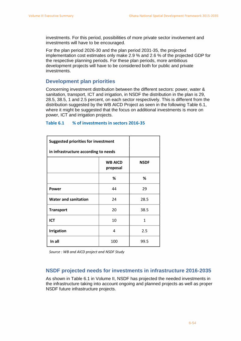
Volume III Executive Summary Ghana National Spatial Development Framework 2015-2035
6-54
investments. For this period, possibilities of more private sector involvement and investments will have to be encouraged.
For the plan period 2026-30 and the plan period 2031-35, the projected implementation cost estimates only make 2.9 % and 2.6 % of the projected GDP for the respective planning periods. For these plan periods, more ambitious development projects will have to be considered both for public and private investments.
Development plan priorities
Concerning investment distribution between the different sectors: power, water & sanitation, transport, ICT and irrigation, in NSDF the distribution in the plan is 29, 28.5, 38.5, 1 and 2.5 percent, on each sector respectively. This is different from the distribution suggested by the WB AICD Project as seen in the following Table 6.1, where it might be suggested that the focus on additional investments is more on power, ICT and irrigation projects.
Table 6.1 % of investments in sectors 2016-35
NSDF projected needs for investments in infrastructure 2016-2035
As shown in Table 6.1 in Volume II, NSDF has projected the needed investments in the infrastructure taking into account ongoing and planned projects as well as proper NSDF future infrastructure projects.
Suggested priorities for investment
in infrastructure according to needs
WB AICD proposal
NSDF
% %
Power 44 29
Water and sanitation 24 28.5
Transport 20 38.5
ICT 10 1
Irrigation 4 2.5
In all 100 99.5
Source : WB and AICD project and NSDF Study

Volume III Executive Summary Ghana National Spatial Development Framework 2015-2035
6-55
6.4.1 Definition of cost units for land and infrastructure
Land for new development
NSDF made an estimation of average land prices in the regions using partly detailed information of land prices from Lands Commission Central Region 2013. NSDF has used farm land prices from a study of the market prices for farm land for sale in Ghana in December 2014 using the internet. In the calculation of the cost of land for urban development, NSD has used the low national average for urban land and the average farmland prices for land for infrastructure projects.
Energy
NSDF has used the cost of the existing planned energy projects prepared by the Ministry of Energy and presented in the draft NIP. The existing projects have been distributed in the implementation time schedule according to the respective plan periods. For new power plans, NSDF has used a unit cost estimate per power plant of 600 million US$.
Roads
NSDF has used different average calculation of road constructions. It also looked at the prices presented in the NIP 2013 plan using average prices. NSDF study has used an average of these prices equivalent to 661,000 US$ per lane km, acknowledging in the meantime that the prices have to be evaluated with the variation expressed in the examples analysed. The studies above also show that longer roads are generally cheaper to construct than shorter roads. The NIP has budgeted for the investment of 14.9 billion US $ in the period 2013-20 equivalent of 2.13 billion US$ per year for roads.
Railways
To calculate the cost of rail construction, NSDF has used the cost per km of single track used by the Consultants in the preparation of the Ghana railway master plan 2013. Though it acknowledges they can be lower. NIP has estimated the needed investment in renovation of rail infrastructure to 4.8 billion US$ in the period 2013-20 making it 0.69 Billion US$ a year.
Airports
International airports require more complex terminal facilities to accommodate passenger transfers. They also tend to have greater concentrations of business facilities, such as shopping, conference centres and hotels, which demand high airport capacity. A key factor affecting investment in international airport facilities is the need for an increasingly wide range of alternative transport systems, such as fixed rail links, to support growing passenger and freight flows and to minimise localized traffic congestion. An example from Malaga, Spain, invested 1.2 billion US$ in the development of the Malaga airport designed for 12 m passengers a year.
NSDF has used the cost estimates of 1.6 and 0.5 billion US $ for the construction of Ghanaian international and national airports of international standards, respectively. NIP has budgeted for 1.6 billion US$ for the period 2013 -20 for upgrading the existing airports and establishing another international and regional airport Tamale.

Volume III Executive Summary Ghana National Spatial Development Framework 2015-2035
6-56
Ports
West Africa is expecting a considerable increase in trade over the next decades and all ports in the region are being modernised to meet the future challenges.
The Ghanaian Harbour Authorities have prepared a master plan considering investment of 2.5 billion US$ to double the capacity before 2018; i.e. with an increased capacity of 2 million TEU a year11. NIP 2013 suggests the investment in new port infrastructure to 3.7 Billion US$ during the next 7 years, equivalent to 0.5 billion US$ per year. NSDF assumes a considerable increased demand for transport to and from the region due to the internal economic development and the advantageous location of the Ghanaian ports for transport to the land locked countries. NSDF also assumes a continuous need for modernisation of the ports and considers 2.9 billion US$ needed for new investments during the planning period at a rate of 290 million per year.
Inland water transport
NIP has budgeted 254 million US$ for the development of the Inland Water transport on Lake Volta from 2015-20 equivalent to 49 million per year. NSDF has used this amount for the budget in the plan period adding 160 million for dredging in the northern part of the Lake making the investment, in total, equivalent to 83 million US $ per year.
Climate change mitigation by afforestation
Afforestation is considered an efficient way to counteract the desertification of land and climate extreme weather conditions, as well as reduce the risk of flooding in areas affected by waters from the afforested area. To calculate eventual cost of afforestation activities NSDF has used costs from an Eritrean tree planting project. The tree planting activity might cost about 2400 US$ per ha and the following continuous maintenance of the replanted area another 580 US$ per ha per year12 or 24.6% of investment. Afforestation of 100 km2 river bank, = 200 km river, per year with forest belt as green corridor or link of 500 m width, would cost 24 million US$.
The cost does not include eventual values from benefits or cost recovery that might come out as a result of the activity, for example reduced risk of flooding or productive activities related to planned and controlled use of timber or combined afforestation and agriculture or cash crop activities.
11 Bloomberg news Nov 2013.
12 WOCAT, experiences from tree planting in Eritrea 2014