geoturbo introducing presented by:. company history established in 1998 by world-renowned expert,...
TRANSCRIPT

GEOTurbo
Introducing
Presented by:

Company History• Established in 1998 by world-renowned
expert, Dr. Stanley Osher
• We produce high quality image processing and data compression software
• We use cutting edge algorithms using advanced computational methods
• We have been awarded several patents for our compression technology
• Our complete software package GeoTurbo is ready and available for purchase

What is GEOTurbo?
• Advanced Software package and plug-in developed for ArcGIS/ArcView platform
• It contains highly efficient tools for compression and denoising of geospatial data
• This is the culmination of careful research, testing and design efforts motivated by the needs of the National Geospatial Agency

Why do I need GeoTurbo?
• Best compression of geospatial data• Unique method for 3D compression of
unorganized data points• Fastest and most accurate denoising
method available today• Allows ESRI users to manipulate,
compress and process data with easily integrated plug-in, available for download at www.levelset.com

Why do I need GeoTurbo compression?
• Collected data take up huge amounts of storage and bandwidth
• Processed and accurately compressed data is necessary for recognition, path planning, line-of-sight calculations
• Faster transmission times, decreased storage requirements, accurate results make technology indispensable

GeoTurbo Capabilities
• 2D and 3D compression
• Image Denoising
• 3D Surface Reconstruction
• Image Processing Techniques: smoothing, dynamic visibility, path planning, topographical structures, quantization
• Import/Export LIDAR LAS formats

Processed original data size: 24MB compressed image: 175 KB*original point cloud data size: 7 MB
GeoTurbo Compression for Unorganized Point Cloud Data

GeoTurbo Surface Reconstruction and Compression of 3D Point Cloud Data
Reconstructed Surface Surface after compression with compression ratio 56:1
Input point cloud data

GeoTurbo Surface and Point Cloud Denoising
Reconstructed surface from point cloud data on the left, and denoised surface on the right. Sharp features are preserved in the denoising process. The point cloud can be denoised by reconstruction the surface, denoising the surface, and then extracting a point cloud from the denoised surface.

Accuracy of GeoTurbo Compression Path Planning
The above demonstrates that path planning on the compressed data is accurate and very close to the paths computed on the uncompressed data.
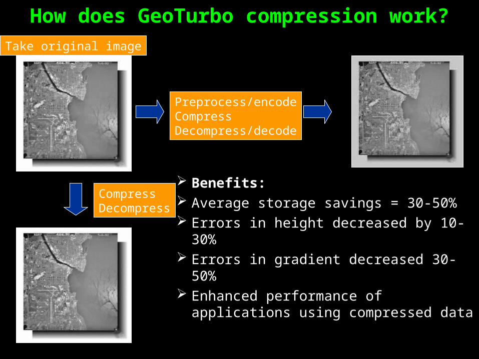
How does GeoTurbo compression work?
Benefits: Average storage savings = 30-50% Errors in height decreased by 10-30% Errors in gradient decreased 30-50% Enhanced performance of
applications using compressed data
Take original image
CompressDecompress
Preprocess/encodeCompressDecompress/decode
Original
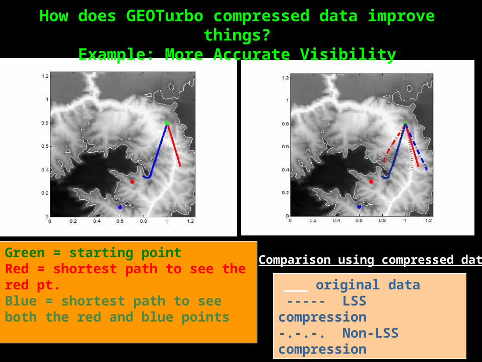
___ original data ----- LSS compression-.-.-. Non-LSS compression
How does GEOTurbo compressed data improve things?Example: More Accurate Visibility
Green = starting pointRed = shortest path to see the red pt.Blue = shortest path to see both the red and blue points
Comparison using compressed data

GEOTurbo License Option
Option Functions
Standard LSS Image Compression
Drainage
Visibility
Smoothing
Geodesics
Quantization
Adaptive Compression
Professional LSS 3D Compression
Import/Export LIDAR
Shrink-Wrap
Denoising
Requires Standard License

GEOTurbo License Pricing
Option Price
Standard (Machine License) U$8000
Professional (Machine License) U$12000
☞ GEOTurbo seats include the first year of maintenance with purchase
☞ Standard software maintenance is 18% of the current list price for GEOTurbo.

How to Contact LSS
Level Set Systems1058 Embury St.Pacific Palisades, CA 90272
Phone: (310) 573-9339Web: www.levelset.comEmail: [email protected]
Contact us for a free trial version of GeoTurbo