geothermal potential in bangladesh – results from … · 2010-09-10 · geothermal potential in...
TRANSCRIPT

Proceedings World Geothermal Congress 2010 Bali, Indonesia, 25-29 April 2010
1
Geothermal Potential in Bangladesh - Results from Investigations of Abandoned Deep Wells
Debendra K. Guha 1, Herbert Henkel 2, Badrul Imam 3 1 Gono University, Dhaka, Bangladesh, email: [email protected]
2 Department of Land and Water Engineering, Royal Institute of Technology, Stockholm, Sweden, email: [email protected] 3 Department of Geology, University of Dhaka, Dhaka, Bangladesh, email: [email protected]
Keywords: Tectonic frame, litho-stratigraphy, temperature, thermal gradients
ABSTRACT
Temperature data for a large number of abandoned deep wells, once drilled for oil and gas exploration, have been collected, together with results from other sources for geothermal conditions. These depend on the ongoing tectonic activity in parts of Bangladesh. Rapidly filling deep sedimentary basins represent volumes with low thermal gradients (ca 20 K km-1), while rising regions with shallow crystalline rocks represent volumes with considerably higher thermal gradients. Several deep drill holes in the SE slope of the Rangpur Saddle have gradients of ca 35 K km-1. This region is currently under further investigation with respect to the hydraulic conductivity of their deep stratigraphic formations. In the central part of the Rangpur Saddle local high groundwater temperatures are observed, especially in connection with graben structures in the crystalline basement where Gondwana age coal containing sedimentary units make up the graben fill. At the base of the coal beds the groundwater temperature is in excess of 50 oC. Further studies are planned in order to determine the thermal gradient, the stress and the fracture status of the rising crystalline basement. A third geothermal target region is the fold belt in the SE part of Bangladesh, where locally warm springs occur. A geothermal map of Bangladesh is presented here for the first time.
The geothermal investigations are a joint project between the Royal Institute of Technology, Sweden and the Department of Geology at the Dhaka University in Bangladesh. The project is sponsored by the Futura Foundation in Stockholm.
1. GEOLOGICAL BACKGROUND
Bangladesh located at the head of the Bay of Bengal, is formed by the successive delta systems developed by the two great rivers of the Ganges (Padma) and the Brahmaputra (Jamuna). The Himalayan mountain ranges were uplifted as a result of the collision with the northward drifting Indian Plate after the break-up of the Gondwana Continent starting in Upper Jurassic / Lower Cretaceous time.
The pre-collision geology of Bangladesh can only be studied in north-western Bangladesh, where the continental Gondwana sequence with alternating carbonaceous sandstone and coal seams were preserved in graben structures of which the shallowest deposits can be seen in the Barapukuria graben at depths of only 117 m. Here the Gondwana (Permian) sediments overlie the Achaean basement which and in turn are unconformably overlain by the Plio-Pleistocene deposits of Dupi Tila Sandstones and Madhupur Clay under a thin alluvial cover. The post-collision geology is a record of uplift in the north, slow
subsidence in the west, and rapid subsidence in the central part with active folding in the east. The volume of accumulated sediments is over 4 million cubic kilometres with a present estimated rate of deposition of about 2.5 billion metric tons per annum (Khan 1991).
The foredeep formed south of the Main Boundary Thrust (MBT) of the Eastern Himalayan Ranges due to the subsidence of the Indian Shield, occupies the north-western part of Bangladesh, where basement is reached at 2500 m depth at Salbanhat well in Tetulia. The Shillong Plateau consisting of Garo-Khasi-Janitia-Mikir Hills of Meghalay (India) with about 2000 m elevation, form the north-eastern boundary of Bangladesh. In contrast the down faulted Surma Basin / Sylhet Trough contains up to 20 km of sediments. The major tectonic elements of Bangladesh thus include the following units – see Figure 1.
Fig.1. Tectonic map of Bangladesh, updated from Guha (1978), showing the major tectonic units discussed in the text.
The Indian Shield/Platform contains Achaean rocks and forms the western margin of Bengal Basin. Vast areas of West Bengal (Midnapur), Bihar (Singbhum) and Orissa

Guha et al
2
have basement outcrops containing gneisses, schists and granites.
The Bengal Foredeep occupies the vast area between the Hinge Line and the Arakan Yoma Folded System and plays the most important role in the tectonic history of Bengal Basin. The Bengal Foredeep can be divided into two major regions: a Western Platform Flank and an Eastern Folded Flank. The Western Platform flank is further subdivided into the Faridpur Trough, the Barisal-Chandpur High, the Hatiya Trough, the Madhupur High and Sylhet Trough.
The Arakan-Yoma Folded System: Only the western marginal part of the Arakan-Yoma Folded System has been shown in the tectonic map (Fig.1). The oldest rocks exposed in the Araka-Yoma belong to the axial system of Triassic age which are highly folded and thrusted and consist of dark shales, sandstones and limestones. A wide belt of Cretaceous and Eocene rocks stretches from the Assam-Myanmar border west of the upper reaches of the Chindwin River along the inaccessible mountainous tracts of the Arakan-Yoma down to Cape Negaris. This vast area of Tertiary folding represents a sub-meridional trending belt of uplifts composed of Pre-Cambrian, Paleozoic and Mesozoic rocks.
It is essential to have clear conception about the structural tectonic framework of Bangladesh in order to evaluate the prospect of mineral resources including the geothermal energy potential. The first tectonic map of the then East Pakistan was prepared by in 1964. Continued improvements were made in connection with hydrocarbon prospecting. Concise characteristic of basic tectonic elements of the then East Pakistan and its adjacent areas prepared in 1965 (Guha and Kitovani 1965). The tectonic framework and oil and gas prospects of Bangladesh were published in Guha (1978 ).In the next chapters, the main geological regions are shortly described from the NW (Sub-Himalayan Foredeep) to the SE (Arakan-Yoma Folded System), with comments on their geothermal prospects.
2. THE TECTONIC UNITS AND THEIR GEOTHERMAL PROSPECTS
2.1 Sub-Himalayan Foredeep.
The Himalayan Foredeep lies south of the Main Boundary Thrust (MBT) all along the foothills of the Himalayas. At Salbanhat, at the NW tip of Bangladesh the basement occurs at 2500 m depth. The temperature at this depth is 79 oC. The Northern Slope of Rangpur Saddle has been included in the Himalayan Foredeep by Reiman (1986) in his tectonic scheme of Bangladesh. The Neocene of the Siwaliks are well developed in the Himalayan Foredeep and attains thickness of 3 to 4.5 km with predominantly sandstones, subordinate shales and clay and gravel beds. Although the sedimentary units have high porosity, the thermal gradient is too low to make a geothermal prospect in association with the only deep well at Salbanhat.
2.2 Rangpur Saddle and the Garo – Rajmahal Gap
The Rangpur Saddle represents the Indian Platform and connects the Indian Shield with the Shillong Massif and the Mikir Hills. The Shillong Massif is a large thrust block of the Indian Shield. In the Rangpur Saddle the basement is most uplifted and covered with thin sedimentary deposits. The tentative boundary of the Rangpur Saddle at the northern and the southern slopes has been seismically defined by the approximately 700 m depth contour. In the Madhyapara area the basement occurs at only 130 m depth and is overlain by Dupi Tila Sandstone and Madhupur Clay
of Plio-Pleistocene age. It is evident from seismic data acquired by the Oil and Gas Development Corporation (OGDC) during 1963-64 in the Rangpur - Dinajpur districts, that both the northern and the southern slopes of Rangpur Saddle are quite gentle. In the southern slope, the basement plunges gently from Madhyapara towards the south east up to the Hinge Zone, an area known as the Bogra shelf. Figure 2 shows an extention of the Tectonic map of Bangladesh covering NW Bangladesh with some further structural features added. Figure 3 shows a generalised thermal section across the Rangpur Saddle.
Fig. 2. Geotectonic map of NW Bangladesh. (the locations of T Thakurgaon, B Barakupuria, J Jairpurhat, M Madhyapara, that are mentioned in the text). The Garo-Rajmahal Gap is between the western and eastern S-N striking fault zones (blue), which seen in the NW-SE direction (Fig. 3) as the Rangpur Saddle. Areas of recent uplift are light gray and outlined green. The region of Gondwana graben structures is dark gray and outlined brown.
An underground mine for extraction of hard rock is now in operation at Madhyapara. There are a number of graben structures in the south-western part of the Rangpur Saddle, some of which have high grade sub-bituminous Gondwana coal of Permian age. At Barapukuria, an underground mine is in operation now. A feasibility study of Gondwana coal deposits found in Khalaspir is yet to be completed, while the feasibility study of Fulbari coal deposit is completed.
The Garo-Rajmahal Gap between the Indian Shield of Rajmahal and the Pre-Cambrian basement of the Garo Hills (Shillong Massif is the result of the Himalayan orogenic movements during the Pleistocene along a NW-SE zone of fractures now occupied by the courses of the Ganges and Brahmaputra rivers. In the western extremity of the Garo Hills, there are a number of basement faults and monoclines trending N-S to NW-SE with persistent dips towards west. The recent Dhubri earthquake epicentre was located along a fault plane in the western margin of the Garo Hills. This fault passing through Dhubri and trending approximately N- S has been traced by geophysical methods for 120 km. On the western part of Garo-Rajmahal gap a similar N-S trending fault has been traced for 160 km from Kishengonj

Guha et al
3
to English Bazar in Malda. These two faults that form the eastern and western margin of Garo-Rajmahal Gap enclose the Rangpur Saddle.
In the western part of the Rangpur Saddle, a number of graben and half graben structures have been found with Gondwana sediments, some of which contain coal seams. The Gondwana sandstone sequence below the coal seams in Barakupuria coal mine has a temperature of 50 oC at a depth of 400 m. The coal seams together have an insolating effect resulting in increased temperature in the basement below.
At Thakurgaon warm water, up to 36 oC, has been observed (Rahman 2006) in irrigation wells at depths of ca 80 m. Here Madhupur Clay (ca 20 m) is acting as an insolating layer, resulting in the observed increased temperatures below. Figure 3 shows a compilation of some observed shallow temperature profiles with their respective litho-stratigraphy.
Fig.3. Generalised section NW-SE across the crystalline basement rise of the Rangpur Saddle (gray). The thermal contours (red) are based on measurements in the Salbanhat and Singra well and the Barapukuria Gondwana graben (green). Geothermal resources in the Rangpur Saddle would be found in the crystalline basement.
As there are no deep wells in the region, the temperatures at depth in the crystalline basement are unknown. To establish a representative temperature profile, a test drill hole to at least 1 km depth would be required. To assess the geothermal potential of the region in addition permeability tests are required for the basement rocks.
By neo-tectonic activity, local areas of upheaval are being developed. The study of these neo-tectonic featured is based on hypsometric maps, maps of erosonal cuttings along rivers, maps of the co-efficient of river meandering together with extensive morphological studies aided by detailed topographic maps, aerial photographs and satellite images. Within the area of the geotectonic Map of NW Bangladesh, these areas up recent upheaval are marked. The ones in Thakurgaon, south of Dinajpur town, in Rangpur and west of Rangpur (Phulbari) are the most prominent. In the Madhupur area, the Madhupur high, the Nagarpur dome, and the Nandina upheaval are noted. (Up to seven prominent upheavals have also been mapped in the Megna estuarial area).
The Rajmal Traps are similar to the Deccan traps in composition and vary from dolerite to basalt in texture. The
Traps extends to the east and south east below the Gangetic plain. They mark the beginning of the break-up of east Gondwanaland from the Southern Super Continent. The sequence comprises of 500-700 m of bedded basalts or dolerites with 35 m thick inter-stratified sedimentary beds (inter- trappean beds) of siliceous and carbonaceous clays and sandstones. The shales have turned procellanoid-like due to heat while in contact with the basalt flows. The Rajmal Stage consists of 15 lava flows and 11 inter-trappean beds in the type locality (Shah 1974). An early Cretaceous (Albian) age (100-105 Ma) has been assigned based on results of K-Argon dating concurrently with paleomagnetic measurements (Mc Daugall 1970).
Fig.4. Near surface temperature profiles in: A Madhyapara (alluvium, clay, sandstone, hard rock, not shown), B Barapukuria (Pliocene sediments (clay yellow), Gondwana sandstone and coal beds (dark gray)), and C Thakurgaon (alluvium, clay (blue), sand, that illustrate the high near surface temperature regime in the Rangpur Saddle.
Basaltic volcanic rocks of Rajmahal Traps have been penetrated in boreholes at Kansat, Patnitola near the Indian border, Singra (68 m) and Kuchma (70 m), but are not encountered in the Bogra well. In wells drilled in the Jamalgonj area farther to the east, only the marginal remnants of the Rajmal Stage were encountered. Rajmahal traps were penetrated in the wells EDH-1 (545m) and EDH-2 (338 m) of the Kansat area, while only minor thicknesses were encountered in the wells EDH-18 (35 m) and EDH-22 (65 m) of the Patnitola area. The exploration Drill Hole (EDH-1) of Kansat encountered a most prolific development of 12 lava flows with 11 inter-trappean sedimentary beds consisting mostly of serpentinized shale. Besides, agglomerate, tuff and ash beds were also encountered. The Rajmahal Trap formation is most likely un-permeable but represents an important marker horizon that may be mapped magnetically.
2.3 Bogra Shelf
The Bogra Shelf (Bogra slope) represents the southern slope of the Rangpur Saddle which is a regional monocline plunging gently towards south east to the Hinge zone (see Fig.1). This zone marks the transition between the Rangpur Saddle and the Bengal Foredeep from depositional as well as structural point of view. The width of Bogra Shelf varies from 60- 125 km. up to the Hinge Zone and the thickness of the sedimentary sequence increases towards the southeast.

Guha et al
4
Stanvac Oil Company (SVOC) carried out aero-magnetic and seismic surveys in the mid-fifties followed by two wells at Kutchma and Bogra. Seismic contours of the top of Eocene Limestone (Bogra Limestone) show regional dip of 2-3 degrees besides revealing a number of NE-SW trending faults of which the Bogra fault is the most prominent. The attitude of the Sylhet Limestone most possibly conforms to the basement surface. Four deep wells have been drilled in the Bogra slope at distances of 22 – 26 km: Singra to the southwest, Bogra to the northeast and Kuchma in between. The litho-stratigraphic correlation between these wells is shown in Figure 5.
Fig.5. Litho-stratigraphic correlation between the wells Singra, Kuchma and Bogra, showing vertical displacements related to faulting and the occurrence of potentially permeable lithologies at depth where temperatures are above the minimum required for electricity production.
The Kutchma well (TD 2875 m) drilled be SVOC in 1959 encountered 495 m thick Gondwana coal bearing sequence at interval 2381-2875 m for the first time which was overlain by 70 m of Rajmahal Trap (Upper Cretaceous), 347 m Cherra Sandstone (Palaeocene), 190 m Eocene Limestone with sandstone bed in the middle, 160 m Barail (Oligocene) and the rest with Mio-Plio - Pleistocene sediments and Holocene deposits.
The Bogra-1 well drilled by SVOC in 1960 with TD 2187 m penetrated 44 m of basement (granite, gneiss, schists and pegmatite) followed by 167 m Cherra Sandstones, 210m of Eocene Limestone with a thin band of Kopili shale and the rest with Oligocene- Miocene- Pliocene- Pleistocene sedimentary sequence without the Gondwana and Rajmahal Traps. Detailed reflection data and their interpretation make it possible to estimate potential volumes of geothermal important lithologies. As an example, the top of the Cherra
Formation is shown in Figure 6. The coverage with reflection seismic lines is in the near surroundings of the two Bogra deep wells gives a rather detailed picture of faults that may restrict lateral permeability.
Fig.6. Seismic time contours (gray) for the top of the Cherra Formation and the location of the wells Bogra-1 and 2. Reflection seismic lines are shown in red, fault zones in blue. Together with a similar map of the base of this formation, the potential volume for geothermal energy production can be assessed. The seismically mapped fault zones limit the direction into which geothermal exploration is be possible.
The Singra well (TD 4100 m) drilled by Petrobangla in 1981 is the deepest well ended at the top of the basement which is overlain by coal bearing Gondwana (1200 m) followed by 7 m of Rajmahal Trap, 113 m of Shibgonj Trap Wash (Upper Cretaceous), 377 m of Cherra Sandstone(Palaeocene), 214 m of Eocene Limestone with a 20 m shale band in the middle, 5 m Kopili Shale (Upper Eocene) 120 m Barail the rest successively by Miocene- Pliocene (Surma and Dupi Tila) and Pleistocene (Madhupur Clay) with a thin alluvial cover.
The Eocene Limestone thins out up-dip from 214 m at Singra to mere 20 m at Jaipurhat where a cement plant was planned based on this subsurface limestone deposit in the early sixties but the project did not succeed. Borehole EDH-4 at Jaipurhat penetrated basement (11 m) on which successively laid a thin bed of Cherra Sandstone, Eocene limestone (20 m), a thin bed of Kopili Shale followed by sediments of Surma Group, Dupi Tila, Madhupur Clay and alluvium. In Jamalgonj Gondwana coal (7 seams) was encountered at interval 850-1122 m. The Krupp Company of Germany made a feasibility report for development of a coal mine but the project did not succeed.
The litho-stratigraphic columns show that faulting took place in the Singra – Kuchma – Bogra area with vertical displacements of about 400 m between Singra and Kuchma occur with respect Sylhet limestone marker horizon. Rajmahal Trap is absent in Bogra while it occurs in Kuchma at a depth of 2.3 km and here the vertical displacement between Kuchma and Bogra is about 700 m, restricted to the stratigraphy below the Sylhet Limestone and Cherra formation.

Guha et al
5
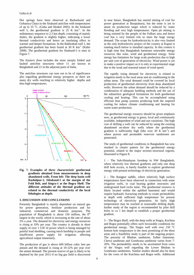
The geothermal gradients observed at Singra, Kuchma and Bogra are very similar, up to 35 K km-1, see Figure 7. In this region, potential geothermal energy resources are in the Sylhet Limestone, the Cherra and Gondwana sequences.
2.4 Deep Sedimentary Basin
The Hinge Zone is a tectonic element of regional importance and has played a major role in the development of the Bengal Basin. It is a narrow zone trending SSW-NNE from Sylhet-Mymensingh-Panba-Calcutta and further to the southwest along the coastline of Orissa. It is bound by the Bogra Shelf (or south slope of the Rangpur Saddle) by the seismic depth of 3500 m to the top of the Eocene Sylhet Limestone, the most prominent sedimentary reflector in Bangladesh and West-Bengal. The seismic depth of 5000 m of the Sylhet Limestone is the south-eastern boundary of the Hinge Zone, also known as the Hinge Line. The dips increase from 3-5 o in the shelf monocline to 15-20 o in the Hinge Zone as evident from Sylhet Limestone. The Hinge Zone is possibly tectonically related to a deep seated basement fault that probably started with the break up of the eastern Gondwana continent. The Sylhet Limestone reflector can be traced into the basin clearly up to 6500 m depth and flattens below 5000 m depth. In the northeast, Hinge Zone is connected with the Dauki Fault by a series of west–east trending faults.
The Faridpur Trough situated adjacent to Hinge Zone and is characterized by a general gravity low and the development of Neocene sequences. The Sylhet Limestone is 6500 m depth in area south of the confluence of the Padma and the Jamuna rivers.
The Barisal-Chandpur High is a tectonic zone of uplift. Located between the Faridpur Trough and the Hatiya Trough of the Bengal foredeep, the Barisal-Chandpur High is characterized by general gravity maxima with SW-NE trend. The width of the zone is about 60 km and corresponds to an uplift of the sedimentary cover.
The Hatiya Trough represents the deepest trough of the Bengal Basin and has received the highest accumulation of clastic sediments. The axis of the Bengal Foredeep runs through the apex of the Hatiya Trough. Shahbazpur (Bhola), Kutubdia, Sangu and a number off-shore anticlinnal structures are located here, of which Sangu is under hydrocarbon production while Shahbazpur and Kutubdia are awaiting development.
The Madhupur High is a Pleistocene terrace separating the Faridpur Trough from the Sylhet Trough (Surma Basin). Here the basement is relatively uplifted as evident from gravity and aero-magnetic data. Morphological studies reveal a pronounced recent morphological upheaval east of Madhupur. The Nagarpur dome and the Nandina high are regarded as protrusions from the basement without deforming the sedimentary sequence overlying these features.
In the deep sedimentary basin the average geothermal gradient is about 20 K km-1, and less, see Figure 7, which is rather low and therefore of limited interest for geothermal resources, unless the abandoned wells are extremely deep.
2.5 Folded Belt
The Folded Belt (or the folded eastern flank of Bengal Foredeep) represents the most prominent tectonic element of the Bengal Foredeep, with general sub-meridional trending hills parallel to the Arakan Yoma Folded System. The Folded belt extends S-N within Bangladesh for 450 km
and is about 150 km wide, covering an area of 35 000 km2 of on-shore area. A large number of narrow, elongated S-N trending folds of the eastern part of Bangladesh, Tripura, southern Assam, Mizoram and the Myanmar territory adjacent SE of the Chittagong Hill Tracts occupy the Folded Belt west of the Arakan Yoma Folded System. The folds are characterized by ridges, box-like in cross section with variable width and high amplitude, oriented en- echelon with the adjacent structures. The elevation of these elongated anticline folds ranges from 100 to1000 m in Bangladesh. Some of the structures are faulted and thrusted and the intensity of folding increases gradually from west to east. Consequently the structures of the eastern part are tightly folded, faulted and thrusted with narrower synclines between them. The Neogene sedimentary sequence developed here are largely un-fossiliferous and consists mainly of the alteration of shales, clays, claystones, siltstones and sandstones with occasional intra-formational conglomerates which an be subdivided into 9 formations on the basis of lithology (Kitovani and Guha 1965) as in Table 1.
The Palaeocene sediments are subsided to greater depths and have not been encountered in any well except in Atgram IX which penetrated 860 m of Renji and 260 m of Jenam sequence of Barail (Reiman 1986). The depth of basement is not known but can be of the range of ca 20 km.
The Folded Belt is sub-divided into a Western Zone and an Eastern Zone according to the intensity of folding and other structural features.The Western Zone consists of a large number of relatively simple anticline structures with 27 known structures in Bangladesh,10 in adjacent regions of India and 3 in Myanmar. The Western Zone is the most important and prospective oil and gas province of Bangladesh with 12 fields from Kailas Tila in the north to Semutang in the south.
Table 1. Stratigraphic units and lithologies in the upper sequences of the Fold Belt.
Group Formation Rock types Thickness (m)
Dupi Tila
Dupi Tila Sandstone (SSt.) and Clay
150 - 1000
Girujain Clays
Clays with SSt. 100 - 300 Tipam
Tipam Sandstones
SSt. with shales (Sh.)
400 – 1 200
Upper Boka Bil
Shales 300 - 400
Middle Boka Bil
SSt. and Sh. alternation
700 - 900
Lower Boka Bil
Shales 300 - 400
Upper Bhuban
SSt. and Sh. alternation
1 200 – 1 500
Middle Bhuban
Shales 800 - 1000
Surma
Lower Bhuban
Sh. and SSt. alternation
1 000-1 200
Guha et al
6
Hot springs have been observed at Barbarkund and Gobaniya Chara in the Sitakund anticline with temperatures of up to 35 oC. (Guha and Henkel 2005). In the Sitakund well 5, the geothermal gradient is 25 K km-1. In the sedimentary sequence to 2.3 km depth, consisting of mainly shales, the gradient is slightly higher, indicating a lower thermal conductivity and hence an insolating effect to warmer and deeper formations. In the Bakhrabad well 1, the geothermal gradient has been found at 30 K km-1 (Kabir 2008). The geothermal gradient for Sitakund-5 is seen in Figure 7.
The Eastern Zone includes the more steeply folded and faulted anticline structures where 11 are known in Bangladesh and 21 in the adjacent parts of India.
The anticline structures can turn out to be of significance also regarding geothermal energy prospects as there are many dry wells reaching to relatively higher depths and thus high temperatures.
Fig. 7. Examples of three characteristic geothermal gradients obtained from measurements in deep abandoned wells. From left: The deep basin well Rashidpur-1, Siltakund-5 at the margin of the Fold Belt, and Singra-1 at the Bogra Shelf. The different attitudes of the thermal gradient are related to the thermal conductivity of the local lithologies at depth.
3. DISCUSSION AND CONCLUSIONS
Presently Bangladesh is mainly dependent on natural gas for power generation, fertilizer production and for industrial, commercial and domestic purposes. The population of Bangladesh is about 150 million, the 8th largest in the world, which is increasing at the rate of about 2% a year. The demand for electricity and energy resources is rising at 10% per year. The country is already in short supply of over 1 GW of power which is being managed by painful load shedding, causing much hardship to people and insufficient power supply for irrigation, affecting agricultural output immensely.
The production of gas is above 600 billion cubic feet per annum and the demand is rising at 10-12% per year over the unmet demand. The present reserve of gas is likely to be depleted by the year 2015 if no big gas field is discovered
in near future. Bangladesh has started mining of coal for power generation at Barapukuria, but the mine is yet to attain its production target which is reduced by water flooding and very high temperatures. Open pit mining is being resisted by the people of the Fulbari area and hence coal has a very limited role to meet the huge energy demand. The scope for hydroelectricity is also very limited as the only hydroelectric project of the country at Kaptai is running much below is installed capacity. In this context it is high time that Bangladesh harnesses renewable energy resources like solar, wind and geothermal energy. Solar energy has limitation for large scale production due to high per unit cost of generation of electricity. Wind power is yet to make a positive impact as it is only at experimental stage due to the weak and seasonal nature of wind speed.
The rapidly rising demand for electricity is related to irrigation needs in the rural areas and air conditioning in the urban areas. The rural demand could be covered by local production of geothermal electricity from deep abandoned wells. However the urban demand should be reduced by a combination of adequate building methods and the use of the subsurface geological formations for both geothermal cooling and heating. This can be accomplished using efficient heat pump systems producing both the required cooling for indoor climate conditioning and heating for warm water production.
The geothermal energy resource should be given emphasis now, as geothermal energy is green, local and continuously available, independent of wind and sun variations. The high cost of drilling a well can be reduced by using the existing abandoned on-shore dry wells where the geothermal gradient is sufficiently high (like over 30 K km-1) and where porous and permeable reservoir sandstones are penetrated.
The study of geothermal conditions in Bangladesh has now resulted in clearer pattern for the geothermal energy potential, related to the major tectonic-structural regions, illustrated in Figure 8.
1 – The Sub-Himalayan foredeep in NW Bangladesh, where relatively low thermal gradients and only one deep drill hole occurs, is barely feasible to explore geothermal energy with present technology of electricity generation.
2 – The Rangpur saddle, where relatively high surface temperatures have been observed in connection with some irrigation wells, in coal bearing graben structures and underground hard rocks mine. The geothermal resource is likely located within the uplifted basement and would require hydraulic fracturing methods to create permeability at depth with sufficient high temperature for present technology of electricity generation. As fairly high temperatures may be reached at reasonable drilling depth, further study of the region is recommended by pilot drill holes to ca 1 km depth to establish a proper geothermal gradient.
3 – The Bogra Shelf, with the deep wells at Singra, Kuchma and Bogra potentially offers such favourable conditions for geothermal energy. The Singra well with over 150 oC bottom hole temperature is the most promising of the three areas and a feasibility study is part of the ongoing project. The porosity of Bhuban sandstone, Sylhet limestone, Cherra sandstone and Gondwana sandstone varies from 7-20%. The permeability needs to be ascertained from cores of the Singra well regarding the Lower Bhuban to Gondwana sandstones. Similar studies should also be done for the cores of the Kutchma and Bogra wells. Additional

Guha et al
7
reflection seismic lines may also needed in the Singra and Kuchma areas for the assessment of available volumes for geothermal energy.
4 – The Deep Basin areas are continuously loaded with cool sediments and the geothermal gradients are very low. Despite some deep drill holes, they are barely feasible to explore for geothermal energy with present technology for electricity generation.
5 – The margin of the Folded Belt, where hot springs occur in connection with local tectonic structures, and the geothermal gradients are relatively high, further mapping of conditions for geothermal energy my be rewarding.
Fig. 8. Geothermal map of Bangladesh showing the temperatures at 3 km depth, based on data of this project in Kabir (2008). The deep wells in the Bogra Shelf are the primary target for further investigations of the geothermal energy potential.
It is strongly recommended that Government of Bangladesh, development partners, donors, non-governmental agencies and private investors give due importance to geothermal energy resource development for power generation.
ACKNOWLEDGEMENTS
This project is a cooperation between the Department of Land and Water Resources Engineering at the Royal Institute of Technology in Stockholm, Sweden and the Departrment of Geology at the Dahaka University in Dhaka, Bangladesh. The project is sponsored by the Futura Foundation in Stockholm. We thank Petrobangla and BAPEX for giving access to their data regarding deep abandoned wells, without which this project would not be possible. We will especially acknowledge the cooperation of the Geothermal Research group at the Geology Department with Prof. Hossein Monsur and the support given to the project by Prof. Monirul Hoque.
REFERENCES
Boris, F., 1963. Petroleum Possibilities of Pakistan. Unpublished Report by French Institute of Petroleum.
Guha, D.K, and Henkel, H., 2005. Abandoned on-shore deep wells-a potential geothermal energy resource for rural Bangladesh. WGC 2005.
Guha,D.K, 1978. Tectonic Framework and Oil & Gas Prospects of Bangladesh. Proc.of the 4th annual Conf. Bangladesh Geol. Soc.: 65-75.
Guha, D.K., Bakhtine, M.I, Giasuddin, A., 1966. Geological Structure and Oil & Gas Prospects of Chittagong Hill Tracts, East Pakistan. Proc. of the 1st . Petroleum symposium by the Petroleum Institute of Pakistan in Karachi.
Guha,D.K, 1973. Oil & Gas Possibilities of Bangladesh. Proc. of 1st Conf. of Geological Society of Bangladesh.
Guha,D.K, 1975. Geology and Oil & Gas prospects of Sylhet District. Proc. 3rd Conf of Geological Society of Bangladesh.
Guha, D.K., and Kitovani, S.K., 1963. Geological Oil & Gas Prospects of Semutang Anticline. Unpublished Report Oil and Gas Development Corporation of Pakistan (OGDC).
Guha, D.K, 1963. Correlation of Neogene Sediments of Chittagong Hill Tracts, East Pakistan. Unpublished Report Oil and Gas Development Corporation of Pakistan (OGDC).
Guha, D.K., and Kitovani, S.K., 1964. Geology and Oil & Gas Prospects of North-Western part of Chittagong and Chittagong Hill Tracts of East Pakistan. Unpublished Report Oil and Gas Development Corporation of Pakistan (OGDC).
Guha,D.K. and Kitovani, S.K., 1965. Geology and Oil & Gas prospects of NW part of Chittagong & Chittagong Hill Tracts with 1st Tectonic Framework of East Pakistan. Unpublished Report Oil and Gas Development Corporation of Pakistan (OGDC).
Guha,D.K., 1966. Geology and Oil & Gas Potential of Bandarban and Sardeng Anticlines of East Pakistan. Unpublished Report Oil and Gas Development Corporation of Pakistan (OGDC).
Guha,D.K. and Giasuddin, A., 1967: Geology and Oil & Gas Prospects of Chittagong and Chittagong Hill Tracts of East Pakistan. Unpublished Report Oil and Gas Development Corporation of Pakistan (OGDC).
Guha,D.K. and Sovolov, I.,1968. Geology and Oil & Gas Prospects of Sylhet area of East Pakistan. Unpublished Report Oil and Gas Development Corporation of Pakistan (OGDC).
Guha,D.K., and Sovolov, I.,1969. Geology and Oil & gas Prospects of Patharia, Harargaj and Fenchugonj Anticlines with special Reference to North Eastern Border Belt of Sylhet of East Pakistan. Unpublished Report Oil and Gas Development Corporation of Pakistan (OGDC).
Ismail, M., and Shamsuddin, A.H.M., 1991. Organic matter maturity and its relation to time, temperature and depth in the Bengal Foredeep, Bangladesh. Journal of Southeast Asia Eart Science 5:381-390.
Kabir, S. M., 2008. Subsurface temperature and geothermal gradient in Bangladesh. Unpublished M.Sc. Thesis at

Guha et al
8
the Department of Geology, Dhaka University. Roll No CH 3202, (2003-4).
Khan, F.H., 1991. Geology of Bangladesh. University Press, Dhaka.
Khandoker, R.A., and Haque, M., 1984. Temperature Distribution and its Relation to Hydrocarbon Accumulation in Sylhet Trough, Bangladesh. Bangladesh Journal of Geology 3:19-25.
Majeed, M.A., 1966. Hundred Years of Oil Exploration in Pakistan. Proc. of the 1st Petroleum Symposium of Pakistan.
Mathur, L.P. and Evans, P, 1964. Oil in India.
Petrobangla 1984. Exploration Opportunity in Bangladesh (PSC Document).
Rahman, M., 2006. Geothermal Potential Resources in Thakurgaon District, Northern Bangladesh. Bangladesh Journal of Geology 25:13-30.
Reiman, K., 1993: Geology of Bangladesh.
Sen Gupta, S., 1966. Geological & Geophysical Studies in Western part of Bengal Basin. Am. Assoc. of Petroleum Geologists Bull. 50:1001-1017.