geoscience north ltd. interpretation report on … · magnetic b field as measured with the...
TRANSCRIPT

Geoscience North Ltd.
Interpretation Report on Borehole TDEM Surveys Junior Lake Property, Armstrong, Ontario For
Landore Resources Canada Inc.
Alan R. King, M.Sc., P.Geo. January 25, 2016
Geoscience North Ltd.
Junior Lake Property 1 Interpretation Report on Borehole TDEM Surveys – January 25, 2016
Introduction Alan King of Geoscience North Ltd. was retained by Landore Resources Canada Inc. for the interpretation of borehole transient electromagnetic (TDEM) surveys recently completed on Landore’s Junior Lake property. These surveys, commonly known as borehole EM (BHEM), were completed December 3 to 14 2015 by Abitibi Geophysics Inc. Eight (8) drill holes were surveyed in the B4-7 nickel-copper-cobalt-PGE deposit area, VW West and BAM East areas.
This report presents the results of this interpretation together with conclusions and recommendations for follow-up exploration works.
Survey Specifications Borehole TDEM Measurements
• Sequential measurement of 3 orthogonal EM components and α, β clinometers • Reading interval: 10 m
Equipment
• Receiver box: SMARTem24 • Tx: TerraScope 18 kW • Motor-Generator: Honda 6 kW • BH Probe: Geonics BH43-3D
Output
• X, Y, Z stacked data profiles, • TDEM data in the as well as data output and survey parameters in Maxwell.prj format
Abitibi delivered the BHEM data in AMIRA.tem format files and also combined with all drillhole trajectories and BHEM system specifications in Maxwell project.prj formats. In the Maxwell format the data is immediately available for interpretation.
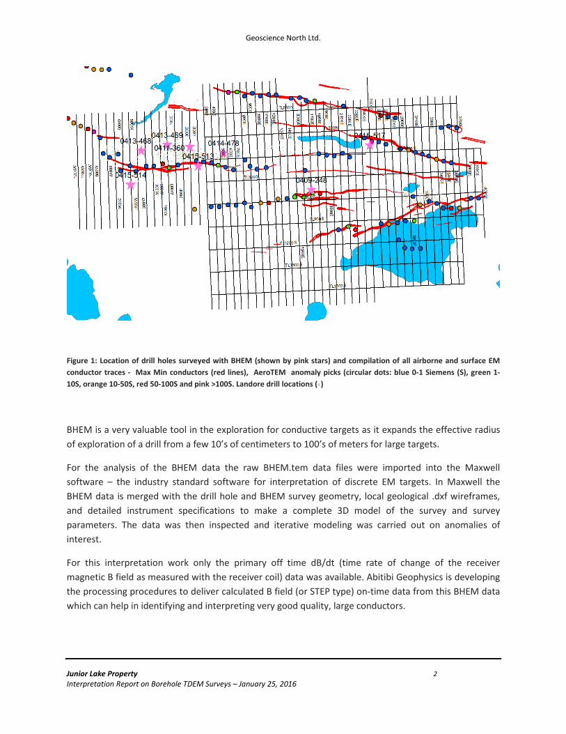
BHEM surveys were done in a total of 8 drill holes; 6 on the B4-7 deposit and one each on the VW West and BAM East areas as shown in Figure 1.
Geoscience North Ltd.
Junior Lake Property 2 Interpretation Report on Borehole TDEM Surveys – January 25, 2016
Figure 1: Location of drill holes surveyed with BHEM (shown by pink stars) and compilation of all airborne and surface EM conductor traces - Max Min conductors (red lines), AeroTEM anomaly picks (circular dots: blue 0-1 Siemens (S), green 1-10S, orange 10-50S, red 50-100S and pink >100S. Landore drill locations (+)
BHEM is a very valuable tool in the exploration for conductive targets as it expands the effective radius of exploration of a drill from a few 10’s of centimeters to 100’s of meters for large targets.
For the analysis of the BHEM data the raw BHEM.tem data files were imported into the Maxwell software – the industry standard software for interpretation of discrete EM targets. In Maxwell the BHEM data is merged with the drill hole and BHEM survey geometry, local geological .dxf wireframes, and detailed instrument specifications to make a complete 3D model of the survey and survey parameters. The data was then inspected and iterative modeling was carried out on anomalies of interest.
For this interpretation work only the primary off time dB/dt (time rate of change of the receiver magnetic B field as measured with the receiver coil) data was available. Abitibi Geophysics is developing the processing procedures to deliver calculated B field (or STEP type) on-time data from this BHEM data which can help in identifying and interpreting very good quality, large conductors.

Geoscience North Ltd.
Junior Lake Property 3 Interpretation Report on Borehole TDEM Surveys – January 25, 2016
Table 1: List of Holes surveyed with BHEM
DDH Area Local Grid Easting
Local Grid Northing
0415-514 B4-7 700W 285S 0414-478 B4-7 550E 85N 0415-513 B4-7 200E 75S 0411-360 B4-7 100E 185N 0413-469 B4-7 200W 221N 0413-468 B4-7 550W 165N 0409-248 VW West 1700E 460S 0415-517 BAM East 2500E 100N
Interpreted plates are coloured by conductor quality (Conductance in Siemens –S)
10,000S or greater hot pink - excellent quality conductance
1,000S to 10,000S hot pink – very good quality conductance
500S to 1,000S red - good conductance
100S to 500S green – moderate conductance
Less than 100S blue – weak conductance for magmatic sulphide targets
It is expected that semi massive to massive magmatic sulphides of the type previously located in the B4-7 zone with a Ni tenor of about 3% in 100% sulphides will be at least 1000S. Since the off time dB/dt data, measured by most Time Domain EM (TDEM) systems, has decreasing sensitivity to very good (much greater than 1000S) and large conductors (>100mx100m) since the time constant of decay of the received signal is much greater than the measurement time of about 8 msec. Hence the higher conductance values in this interpretation are considered to be minimum values. Plates with greater than 1000S and greater than 10000 S are both coloured pink as the dB/dt BHEM data starts to lose conductance discrimination in this range and any plates in this range are of high interest.
Conductance varies with the type of mineralization and degree of electrical connection. Hence it is only an approximate measure of target quality and should only be used as a guide for drilling. The descriptive terms used here “weak to excellent” are not quantitative and are relative to the main target type in the B4-7 area which is moderate tenor magmatic sulphides.
Each BHEM survey was reviewed several times. First to find one or more conductive plates that approximately reproduce the observed data, and then again as required to get the best fitting combination of plates possible to explain the observed data. Since the principal exploration target in the
Geoscience North Ltd.
Junior Lake Property 4 Interpretation Report on Borehole TDEM Surveys – January 25, 2016
vicinity of the B4-7 deposit is massive to semi massive sulphides only the Late Time (LT) channels (Ch 18 plus) of the BHEM data were used. This will identify the most conductive plates or parts of plates that are expected to correspond to electrically well connected semi massive to massive sulphides. These plates represent only the most conductive areas around the drillhole and may not represent the full size of the conductive system.
Recent results from the BAM East area (drill holes 0415-517 and 0415-518 on line 2500E) indicate that lower conductance targets may be of interest for gold exploration. Interpretation in this area may benefit from re-interpretation using earlier time channels. In this case the location and orientation of the most conductive plates or parts of plates is not likely to change but the size of the conductive system may increase and/or more weakly conductive plates may be apparent.
In general, interpreted plates are classified as in hole (positive Axial component) and off hole (-ve Axial component). In hole plates are conductive systems that have been intersected by the drill hole and off hole plates are conductive systems that are located away from the drill hole.
It should be noted that for BHEM systems and EM systems in general a conductive plate can be “seen” by the system about as far away as it is across. For example, a 200m long by 100m wide thin sheet can be seen about 100m away from the hole. A 100m sphere could be seen about 100m away. This is a general rule of thumb and results may vary with conductor geometry coupling to the transmitter etc. Also, smaller conductive plates may not detectable if they are minimum coupled to the primary field from the transmitter. In general this is not expected to be a problem on this project as the dip and strike of the expected mineralization was well known and the transmitter loops was set up for good coupling.
Discussion of BHEM interpretation results The following is a list of interpreted conductive plates – plates are identified first by drillhole number and then by ancillary data related to that particular model.
Geoscience North Ltd.
Junior Lake Property 5 Interpretation Report on Borehole TDEM Surveys – January 25, 2016
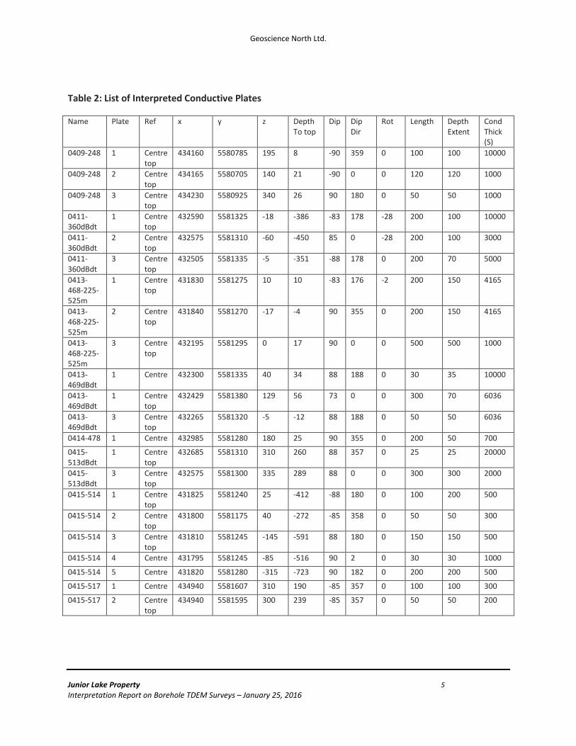
Table 2: List of Interpreted Conductive Plates
Name Plate Ref x y z Depth To top
Dip Dip Dir
Rot Length Depth Extent
Cond Thick (S)
0409-248 1 Centre top
434160 5580785 195 8 -90 359 0 100 100 10000
0409-248 2 Centre top
434165 5580705 140 21 -90 0 0 120 120 1000
0409-248 3 Centre top
434230 5580925 340 26 90 180 0 50 50 1000
0411-360dBdt
1 Centre top
432590 5581325 -18 -386 -83 178 -28 200 100 10000
0411-360dBdt
2 Centre top
432575 5581310 -60 -450 85 0 -28 200 100 3000
0411-360dBdt
3 Centre top
432505 5581335 -5 -351 -88 178 0 200 70 5000
0413-468-225-525m
1 Centre top
431830 5581275 10 10 -83 176 -2 200 150 4165
0413-468-225-525m
2 Centre top
431840 5581270 -17 -4 90 355 0 200 150 4165
0413-468-225-525m
3 Centre top
432195 5581295 0 17 90 0 0 500 500 1000
0413-469dBdt
1 Centre 432300 5581335 40 34 88 188 0 30 35 10000
0413-469dBdt
1 Centre top
432429 5581380 129 56 73 0 0 300 70 6036
0413-469dBdt
3 Centre top
432265 5581320 -5 -12 88 188 0 50 50 6036
0414-478 1 Centre 432985 5581280 180 25 90 355 0 200 50 700
0415-513dBdt
1 Centre top
432685 5581310 310 260 88 357 0 25 25 20000
0415-513dBdt
3 Centre top
432575 5581300 335 289 88 0 0 300 300 2000
0415-514 1 Centre top
431825 5581240 25 -412 -88 180 0 100 200 500
0415-514 2 Centre top
431800 5581175 40 -272 -85 358 0 50 50 300
0415-514 3 Centre top
431810 5581245 -145 -591 88 180 0 150 150 500
0415-514 4 Centre 431795 5581245 -85 -516 90 2 0 30 30 1000
0415-514 5 Centre 431820 5581280 -315 -723 90 182 0 200 200 500
0415-517 1 Centre 434940 5581607 310 190 -85 357 0 100 100 300
0415-517 2 Centre top
434940 5581595 300 239 -85 357 0 50 50 200
Geoscience North Ltd.
Junior Lake Property 6 Interpretation Report on Borehole TDEM Surveys – January 25, 2016
B4-7 Deposit Area
0415-514
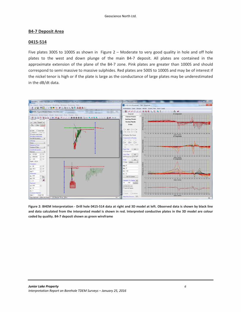
Five plates 300S to 1000S as shown in Figure 2 – Moderate to very good quality in hole and off hole plates to the west and down plunge of the main B4-7 deposit. All plates are contained in the approximate extension of the plane of the B4-7 zone. Pink plates are greater than 1000S and should correspond to semi massive to massive sulphides. Red plates are 500S to 1000S and may be of interest if the nickel tenor is high or if the plate is large as the conductance of large plates may be underestimated in the dB/dt data.
Figure 2: BHEM Interpretation - Drill hole 0415-514 data at right and 3D model at left. Observed data is shown by black line and data calculated from the interpreted model is shown in red. Interpreted conductive plates in the 3D model are colour coded by quality. B4-7 deposit shown as green wireframe

Geoscience North Ltd.
Junior Lake Property 7 Interpretation Report on Borehole TDEM Surveys – January 25, 2016
0414-478
One plate 700S as shown in Figure 3 - A single well defined, good quality, in hole LT response in the plane of and east of the B4-7 deposit. This plate has moderate size and good but not very good conductance.
Figure 3 - BHEM Interpretation - Drill hole 0414-478 data at right and 3D model at left. Observed data is shown by black line and data calculated from the interpreted model is shown in red. Interpreted conductive plates in the 3D model are colour coded by quality. B4-7 deposit shown as green wireframe

Geoscience North Ltd.
Junior Lake Property 8 Interpretation Report on Borehole TDEM Surveys – January 25, 2016
0415-513
Two plates 2000S to 20000S as shown in Figure 4 -Two well-defined in and near hole responses on or near the plane of the B4-7 deposit. There is one small excellent quality plate indicating strong local conductance near the hole and a larger very good quality plate that represents the main B4-7 deposit.
Figure 4 - BHEM Interpretation - Drill hole 0415-513 data at right and 3D model at left. Observed data is shown by black line and data calculated from the interpreted model is shown in red. Interpreted conductive plates in the 3D model are colour coded by quality. B4-7 deposit shown as green wireframe

Geoscience North Ltd.
Junior Lake Property 9 Interpretation Report on Borehole TDEM Surveys – January 25, 2016
0411-360
Three plates 3000S to 10000S as shown in Figure 5 – Three very good to excellent quality plates in or just below the B4-7 zone in the plane of the B4-7 zone.
Figure 5 - BHEM Interpretation - Drill hole 0411-360 data at right and 3D model at left. Observed data is shown by black line and data calculated from the interpreted model is shown in red. Interpreted conductive plates in the 3D model are colour coded by quality. B4-7 deposit shown as green wireframe

Geoscience North Ltd.
Junior Lake Property 10 Interpretation Report on Borehole TDEM Surveys – January 25, 2016
0413-469
Three plates 6000S to 10000S, Figure 6 - Two excellent quality in and off hole plates in the plane of the B4-7 zone in or just below the B4-7 zone and another excellent quality off hole plate just up the hole from the main plane of the B4-7 zone. This plate is in the Alpha mineralized zone and suggests that there may be some small patches of very strong mineralization in this zone .
Figure 6 - BHEM Interpretation - Drill hole 0413-469 data at right and 3D model at left. Observed data is shown by black line and data calculated from the interpreted model is shown in red. Interpreted conductive plates in the 3D model are colour coded by quality. B4-7 deposit shown as green wireframe
Geoscience North Ltd.
Junior Lake Property 11 Interpretation Report on Borehole TDEM Surveys – January 25, 2016
0413-468
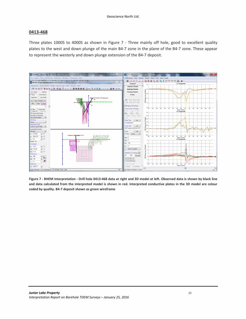
Three plates 1000S to 4000S as shown in Figure 7 - Three mainly off hole, good to excellent quality plates to the west and down plunge of the main B4-7 zone in the plane of the B4-7 zone. These appear to represent the westerly and down plunge extension of the B4-7 deposit.
Figure 7 - BHEM Interpretation - Drill hole 0413-468 data at right and 3D model at left. Observed data is shown by black line and data calculated from the interpreted model is shown in red. Interpreted conductive plates in the 3D model are colour coded by quality. B4-7 deposit shown as green wireframe

Geoscience North Ltd.
Junior Lake Property 12 Interpretation Report on Borehole TDEM Surveys – January 25, 2016
VW West
0409-248
Three plates 1000S to 10000S as shown in Figure 8 - Two good to very good and one excellent quality plates. All are off hole plates and all on different horizons.
Figure 8 - BHEM Interpretation - Drill hole 0409-248 data at right and 3D model at left. Observed data is shown by black line and data calculated from the interpreted model is shown in red. Interpreted conductive plates in the 3D model are colour coded by quality
Geoscience North Ltd.
Junior Lake Property 13 Interpretation Report on Borehole TDEM Surveys – January 25, 2016
BAM East
0415-517
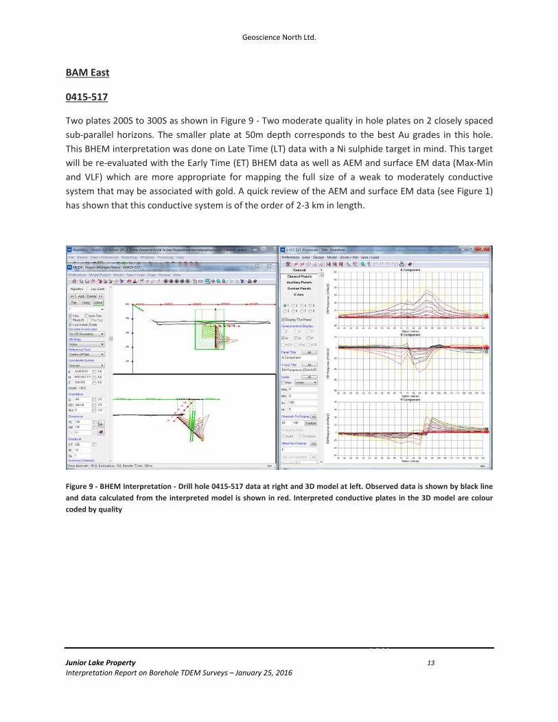
Two plates 200S to 300S as shown in Figure 9 - Two moderate quality in hole plates on 2 closely spaced sub-parallel horizons. The smaller plate at 50m depth corresponds to the best Au grades in this hole. This BHEM interpretation was done on Late Time (LT) data with a Ni sulphide target in mind. This target will be re-evaluated with the Early Time (ET) BHEM data as well as AEM and surface EM data (Max-Min and VLF) which are more appropriate for mapping the full size of a weak to moderately conductive system that may be associated with gold. A quick review of the AEM and surface EM data (see Figure 1) has shown that this conductive system is of the order of 2-3 km in length.
Figure 9 - BHEM Interpretation - Drill hole 0415-517 data at right and 3D model at left. Observed data is shown by black line and data calculated from the interpreted model is shown in red. Interpreted conductive plates in the 3D model are colour coded by quality
VW
DC6
Geoscience North Ltd.
Junior Lake Property 14 Interpretation Report on Borehole TDEM Surveys – January 25, 2016
Conclusions
The BHEM data was of good quality but could benefit from additional B field type processing which can be useful for identifying the highest conductance, large conductors which most likely to represent economically viable NiS mineralization.
Good quality plates in the vicinity and/or on the same horizon as the B4-7 zone are likely to represent Ni bearing sulphides similar to those in the B4-7 zone. The BHEM results show numerous good quality conductive zones in and around the B4-7 zone which may have not been tested. B field data may show better quality targets.
Late time BHEM interpretation in DH 0415-517 on the BAM East zone showed a moderate quality in hole plate at about 50m depth that corresponds to the best Au grades in this hole. This target will be re-evaluated with the Early Time (ET) BHEM data as well as AEM and surface EM data (Max-Min and VLF) which are more appropriate for mapping the full size of a weak to moderately conductive system that may be associated with gold. Results from this work will be the subject of a future report.
Recommendations
1) The interpreted plates around the B4-7 zone should be correlated with existing drill holes. Good quality plates (>1000S) that are not explained by current drilling should be tested with new holes as these are likely to represent good quality mineralization similar to that already intersected existing B4-7 resource.
2) Get B field BHEM data from Abitibi Geophysics. Only the primary off time dB/dt (time rate of change of the receiver magnetic B field as measured with the receiver coil) data was available for this interpretation. Abitibi Geophysics is developing the processing procedures to deliver calculated B field (or STEP type) on-time data from this BHEM data which can help in identifying and interpreting very good quality, large conductors.
3) Review BAM East conductive horizon with the Early Time (ET) BHEM data as well as AEM and surface EM data (Max-Min and VLF)
Geoscience North Ltd.
Junior Lake Property 15 Interpretation Report on Borehole TDEM Surveys – January 25, 2016
Statement of Qualifications
I, Alan R. King, declare that
I am a Consulting Geophysicist with residence in Sudbury, Ontario and am presently employed in this capacity with Geoscience North Ltd., Sudbury, Ontario;
I obtained a Bachelor of Science Degree (B.Sc.), in Geology from the University of Toronto in 1976, and a Master of Science Degree (M.Sc.), in Geophysics from Macquarie University in 1989;
I am a registered geophysicist with a license to practice in the Province of Ontario (APGO member # 1178);
I have practiced my profession continuously since 1976 in North and South America, Australasia;
I am a member of the Society of Exploration Geophysicists, and the Australian Society of Exploration Geophysicists;
I have no interest, nor do I expect to receive any interest in the properties or securities of Landore Resources Canada Inc., its subsidiaries or its joint-venture partners;
I am the Professional Geophysicist and a member in good standing of APGO who has authored this Geophysical Report;
The statements made in this report represent my professional opinion in consideration of the information available to me at the time of reviewing this report.
Sudbury, Ontario January, 2016
Alan R. King, M.Sc, P.Geo. Geoscience North Ltd.