georgia coastal management program - national … administration (noaa), the georgia coastal...
TRANSCRIPT

Georgia Coastal Management Program Section 309 Assessment
Final Assessment
April 15, 2011

2
I. Introduction Section 309 of the Coastal Zone Management Act identifies nine Program Enhancement Areas, including: wetlands, coastal hazards, public access, marine debris, cumulative and secondary impacts, ocean resources, energy and government facility siting, aquaculture and Special Area Management Plans. In accordance with the requirements of the National Oceanic and Atmospheric Administration (NOAA), the Georgia Coastal Management Program (GCMP) has completed an assessment of the extent to which the State’s Program identified problems and opportunities for each of the enhancement areas; determined the effectiveness of the Program’s existing efforts to address problems for each of the enhancement objectives; and identified priority needs for Program enhancements for the period 2011-2015. The Assessment was developed by the GCMP in accordance with NOAA’s guidelines for a Section 309 Assessment and Strategy. Staff with expertise in each of the nine enhancement areas responded to questions to assess whether the GCMP’s existing efforts satisfactorily addressed the objectives of each enhancement area and noted whether deficiencies in data, program activity or policy resulted in an inability of the state to meet stated objectives. For enhancement areas for which deficiencies were noted, the GCMP ranked each area in terms of the Program’s priority for addressing them. Priority was determined based on the perception of immediate need and whether the identified gaps were being addressed through other means. Due to limited funding and program capacity, the GCMP was only able to determine two enhancement areas as high priority. The GCMP ranked two enhancement areas as high priority, Coastal Hazards and Ocean Resources, and developed 5-year strategies to address program needs within those areas. The strategy for Coastal Hazards will involve the development of a Post-Disaster Redevelopment Plan for coastal Georgia. This strategy will take 5-years and will cost approximately $787,923 in funding from NOAA. The strategy for Ocean Resources will involve the development the Georgia Ocean Planning Initiative to address the multiple uses of the State’s ocean and near-shore waters. This strategy will also take 5-years to complete and will cost approximately $454,077 in funding from NOAA. As required by NOAA, on October 14, 2010, the Georgia Coastal Management Program’s Draft Section 309 Assessment and Strategy was made available for public comment. A public notice was sent to local media to inform the public that written comments would be received through November 19, 2010. An overview of the Assessment and Strategy was presented to the Coastal Advisory Council on November 4, 2010. In addition, the Assessment and Strategy was posted in the DNR Coastal Resources Division website. One public comment was received and is summarized below: In general, the comment indicated concurrence with the Program’s overall assessment of
existing threats to coastal natural resources. However, it was noted that ocean shorelines exposed to high hazards should be considered under threat.
The comment noted that the assessment of threats did not include a discussion of the regulatory framework of the Program.

3
Regarding the Program’s assessment of Cumulative and Secondary Impacts, it was noted that there is not a comprehensive study of the individual impacts of permitted activities and no study of the cumulative impacts of multiple permitted activities, and, without assessment of site-specific and cumulative impacts, the major threats identified in the Assessment cannot be reduced or eliminated.
The comments were addressed in the Cumulative and Secondary Impact (CSI) Assessment in the following manner: ocean shorelines exposed to high hazards were added as a threat; the ability to address CSI at the state level acknowledges a gap in regulatory processes; and a tracking mechanism for CSI in the coastal zone was acknowledged as a need.
II. Summary of Completed Section 309 Efforts The GCMP’s last Section 309 Assessment was completed in 2005 and resulted in three 5-year strategies addressing gaps in two program enhancement areas. The first strategy, under the Wetlands Program Enhancement Area, called for the development of a Coastal Compliance and Enforcement Program. Specifically, this strategy provided funding for the development and implementation of enforcement protocols related to the GCMP’s regulatory authorities under the Coastal Marshlands Protection Act and Shore Protection Act. In the 5 years since the start of this strategy, the GCMP has implemented a robust program of inspections for permitted projects and routine patrol for Un-authorized Activities (UAs), and developed a basis for consistent enforcement of non-compliant activities. As this strategy nears completion in 2011, the GCMP will seek approval from NOAA to officially include the Compliance and Enforcement Program into the federally approved GCMP through a request for Routine Program Change. A second strategy under the Wetlands Program Enhancement Area called for the development and implementation of a Coastal Wetlands Restoration Program. This 5-year strategy first sought to identify degraded coastal marshlands (salt marshes) in the coastal zone with the intention of evaluating these sites for possible restoration. Drawing upon the expertise of a variety of coastal wetland specialists, the strategy also proposed to develop State guidelines for salt marsh restoration, as well as permitting criteria. This strategy is still ongoing, to date having developed a protocol for identifying degraded wetland sites, completing an inventory of degraded sited throughout 6 coastal counties, and establishing a Wetlands Working Group. The GCMP has also leveraged other efforts ongoing within the Division that includes updates to the coastal National Wetlands Inventory maps with modifiers for function, and the development of a Rapid Assessment protocol for coastal marshlands. These efforts, funded by the US Environmental Protection Agency, will enable this strategy to develop a wetland restoration program that is much more comprehensive than initially envisioned. Long-term the goal of the strategy is to develop a wetlands restoration program that will be housed within the GCMP. A request to NOAA to officially include this program under the GCMP through a Routine Program Change will be made at the conclusion of this strategy. A final strategy was developed to address gaps related to the Aquaculture Program Enhancement Area. The 2005 Assessment revealed that the State did not have a grasp on the extent of its

4
oyster populations and therefore needed better information in which to manage the resource and site new shellfish growing and lease areas. A component of this strategy focused on mapping the extent of coastal Georgia’s oyster reefs in Chatham, Bryan, Liberty and McIntosh counties, as funds allowed. The strategy also included an evaluation of State policies and procedures related to oyster restoration and resulted in the development of an expedited blanket permit template for state agencies and universities to use in the pursuit of restoration projects throughout the coastal zone (adjacent to public and private lands). The strategy also addressed policies related to Shellfish Growing Areas, e.g., the areas in which clams and oysters can be legally harvested. As the designation of a Shellfish Growing Area is wholly dependent upon routine monitoring for near-pristine water quality conditions with respect to fecal contamination, it is very important that the State have the rules in place to protect these areas. A review of state policies revealed inconsistencies within the Rules for Water Quality. GCMP worked with the Environmental Protection Division to address the issue and draft new rules. Approval of the rule changes is anticipated in 2011. At that time, the GCMP will seek to incorporate the rule revision into the GCMP through a request for Routine Program Change.

5
1. Assessment
Wetlands Section 309 Enhancement Objective Protection, restoration, or enhancement of the existing coastal wetlands base, or creation of new coastal wetlands Resource Characterization Purpose: To determine the extent to which problems and opportunities exist with regard to the enhancement objective. 1. Please indicate the extent, status, and trends of wetlands in coastal zone using the following table:
Wetlands type
Estimate Historic Content (acres)
Current Extent (acres)
Trends in Acres lost Since 2006 (net acres gained & lost)
Acres gained through voluntary mechanisms since 2006
Acres gained through mitigation since 2006
Year and source(s) of Data
Tidal (vegetated)
534,590 1,731,001.47 727.64 acres permitted impact; 28,604 linear ft. permitted impact; 2,763.11 acres mitigated
Unknown acreage
2763.11 acres
1996, Project Report 26; ACE
Tidal (non-vegetated)
(Included with above)
(Included with above)
(Included with above)
Unknown acreage
(Included with above)
(Included with above)
Fresh 1,194,376 (Included with above)
(Included with above)
Unknown acreage
(Included with above)
1996, Project Report 26; ACE
Other 2. If information is not available to fill in above table, provide a qualitative description of information requested, including wetlands status and trends, based on the best available information.

6
The above acreage is calculated using the same data source as the 2001 and 2005 assessment data (State of Georgia Landcover Statistics by County, Project Report 26, Georgia DNR, Atlanta, 1996) and adjusted based on records of permitted impact and required mitigation from the Army Corps of Engineers. The same classification system was used to keep the data comparable and allow for trend analysis. The historic content estimate is the same as the two previous assessments and was calculated based on Project Report 26, which used 1988 imagery data. The Corps switched to a new database system in 2006, so data entry methods did not document if impact was in tidal or non-tidal area for all entries. Therefore, all permitted impact and mitigation acres are combined in the tidal (vegetated) wetlands type category. 3. Provide a brief explanation for trends. The overall trends based on permitted impacts and required mitigation show a net increase in tidal wetlands created from mitigation of 2,035.47 acres. There were 727.64 acres of wetlands impacted through the ACE permitting process, and 2,763.11 acres created through mitigation. Linear feet are more difficult to capture as a trend because it is not converted to acreage. There was 28,604 linear feet of permitted impact to rivers, streams or open water. Salt marsh wetlands should remain at a steady level (except for impacts from exempt agencies) due to an effective state regulation, the Coastal Marshlands Protection Act, enacted in 1970. Coastal marshlands are defined by a fixed elevation above sea level or by a series of 14 jurisdictional plant species known for their ability to survive in a saline environment. This definition does not extend to those wetlands that are tidally influenced by freshwater. Tidal wetland trends have been captured in this assessment using data from the Army Corps of Engineers database of permitted activities. This data summarized the acres of impacted or filled wetlands as well as the acreage restored through mitigation from 2006-2010. These figures were then calculated against the extent reported in the 2005 assessment. It would be beneficial to use mapped wetland types to calculate acreage rather than land cover classifications from the 1996 Project Report 26. The US EPA has funded a mapping update to the National Wetlands Inventory for the 6 coastal counties, but this data does not extend into the entire 11-county GCMP region. This data is useful to calculate current acreage of wetland types in those counties, but was not used in the above calculations due to the fact that no comparisons could be made to the 2005 assessment and the updates do not cover the entire 11 county GCMP region. The most informative trend data therefore, would be the acreage impacted and mitigated from the Corps rather than current extent. Current extent in acreage will vary depending on the data source used. 4. Identify ongoing or planned efforts to develop monitoring programs or quantitative measures for this enhancement area. The Georgia Coastal Management Program is currently implementing two EPA Wetlands Program Development Grants. The first grant is funding the following efforts:

7
• Living shoreline demonstration project on Sapelo Island. The goals of this project are to study the feasibility of alternative techniques to traditional shoreline hardening in tidal wetlands (i.e. alternatives to riprap and bulkheads), and to determine the effectiveness of alternative erosion control methods that will protect and enhance ecosystem function.
• GIS mapped database of all hardened shoreline in the coastal zone including riprap, bulkheads and other hard armoring structures along the coast and in tidal estuaries.
• National Wetlands Inventory update of the 6 coastal counties. This update used 2006 aerial imagery and was completed in June 2010.
The second EPA Wetlands Program Development Grant is funding the following efforts: • Development of local wetland monitoring scheme and rapid wetland assessment tool. This
data will contribute to EPA’s National Condition Assessment. • NWI Plus – Functional Assessment for wetlands in coastal Georgia. The U.S. Fish and
Wildlife Service has been developing techniques to use its National Wetlands Inventory (NWI) data to predict wetland functions for watersheds. Recognizing the value of adding hydrogeomorphic properties to the NWI database (i.e., increased functionality), the NWI created a set of hydrogeomorphic-type descriptors that could be added to NWI types to facilitate predicting wetland functions. The combination of these attributes with traditional NWI types can be called “NWIPlus” resulting in an enhanced NWI database.
Other current initiatives include: • Wetland Restoration Inventory of impaired wetlands in Chatham, Bryan, Glynn and Camden
Counties (the inventory will focus on Georgia state-owned properties east of Interstate 95). This inventory is being completed as part of the 2005 Wetlands Strategy. Sites will be identified and impacts categorized using aerial imagery and field evaluations. Documented sites will serve as candidates for possible restoration projects coast wide based on type and acreage of impairment
• Coastal Georgia Shellfish Inventory in ArcGIS. Researchers from UGA’s Marine Extension Service on Skidaway Island have spent several years inventorying shellfish areas within Chatham, Liberty and McIntosh Counties. Within these inventoried areas, researchers mapped 93.5 acres of oyster reef
5. Use following table to characterize direct and indirect threats to coastal wetlands, both natural and man-made. If necessary, additional narrative can be provided below to describe threats.
Type of threat Severity of Impacts (H, M, L)
Geographic scope of impacts (extensive or limited)
Irreversibility (H, M, L)
Development/Fill
H Extensive in FW wetlands H
Alteration of hydrology
H Extensive in FW wetlands H
Erosion H Extensive in coastal tidal streams and estuaries H Pollution M Nonpoint Source Pollution can affect coastal
streams (localized events and impacts from inland activities)
M
Channelization M Existing impacts from previous decades, some M

8
restoration efforts to return to natural flow Nuisance or exotic species
M Seeing an increase in exotics and invasives in offshore and coastal regions (pink barnacle, lionfish etc)
M
Freshwater Input
H Extensive as inland land use change occurs M
SLR H Extensive – entire coastal region will be affected
H
Other 6. (CM) Indicate whether the Coastal Management Program (CMP) has mapped inventory of the following habitat types in the coastal zone and the approximate time since it was developed or significantly updated.
Habitat Type CMP has mapped inventory (Y/N)
Date completed or substantially updated
Tidal Wetlands Y 2010 Beach and Dune Y 2010 Nearshore Y 2010 Other Y 2010 The Georgia Coastal Management Program (GCMP) has participated in several projects providing updated mapped inventories of habitats in the coastal region. The GCMP received an EPA Wetlands Program Development Grant to fund a partial update to the National Wetlands Inventory for coastal Georgia. The update covered the 6 coastal counties of Chatham, Bryan, Liberty, McIntosh, Glynn and Camden. This data was completed in June of 2010 using 2006 aerial imagery. The GCMP has also partnered with Wildlife Resources Division of DNR, The Georgia Conservancy, and ACCG for the Coastal Georgia Land Conservation Initiative (CGLCI). The first phase of this project was an in-depth Habitat Assessment conducted by WRD, and will be completed by the end of 2010. Biologists used aerial imagery and in depth field evaluations to map all vegetative habitats using Nature Serve’s classification system. This data will be used in future analyses to model land conservation priorities opportunities. 7. (CM) Use table below to report information related to coastal habitat restoration and protection. The purpose of this contextual measure is to describe trends in the restoration and protection of coastal habitat conducted by the State using non-CZM funds or non-Coastal and Estuarine Land Conservation Program (CELCP) funds. If data is not available to report for this contextual measure, please describe below actions the CMP is taking to develop a mechanism to collect the requested data.
Contextual Measure Cumulative Acres for 2004-2010
# acres of coastal habitat restored using non-CZM or non-CELCP funds
.5 acre
# acres of coastal habitat protected through acquisition or easement using non-CZM and non-CELCP funds
62,689 acres

9
Coastal habitat restored using non-CZM or non-CELCP funds include the Living Shoreline demonstration project. This project was funded through an EPA Wetlands Program Development Grant. The demo project used alternative stabilization techniques to restore a severely eroding shoreline in a tidal creek on Sapelo Island. Coastal habitat protected through acquisition or easement using non-CZM and non-CELCP funds include the following projects: • In 2006 The Nature Conservancy, with International Paper and The Conservation Fund
acquired for conservation 218,000 acres of ecologically important forests, rivers and streams in 10 southern states as part of the Southern Forests Conservation Project. The project protected 24,120 acres in Georgia along the Altamaha River and was the largest land conservation agreement ever completed in Georgia.
• In 2009 Georgia DNR received a National Coastal Wetlands Conservation Grant, and a
North American Wetlands Conservation Act Grant, both administered by the US Fish and Wildlife Service, and state funds to acquire the 7,180-acre Murff Tract located along the Altamaha River adjacent to the Altamaha Rayonier Natural Area. This tract is considered the largest, most ecologically intact, and most important unprotected area in the lower Altamaha River Watershed. The Nature Conservancy has designated the lower Altamaha River watershed as one of the “Last Great Places” because of the diverse natural communities and rare plants and animals that occur there.
• The Georgia Land Conservation Center (GLCC) in cooperation with the Savannah Army
Corps District and the Interagency Review Team manages the Georgia Wetlands and Streams Trust Fund (GWSTF). The GWSTF was established as a compensatory mitigation option for the wetlands impacts permitted under Section 404 of the Clean Water Act. When the Corps issues a permit with mitigation requirements a fee is paid to the GSWTF by the permittee and the GLCC works with qualified partners to preserve sites throughout the region. In 2008 the GWSTF provided $550,000 to The Nature Conservancy (TNC) to acquire the Barrington Tract A-1 (McIntosh County) and donate it to the GA DNR to be part of the Lower Altamaha Wildlife Management Area. The 200-acre tract includes 111 acres of wetlands. Also in 2008, the GSWTF provided $100,000 to TNC to acquire a permanent conservation easement on the Fort Barrington Club Land. The easement will be part of TNC’s Lower Altamaha Preserve. The 1,027-acre tract includes 1,027 acres of wetlands and 23,637 linear feet of stream, much of which are part of the main stem of the Altamaha River.
• The Wetlands Reserve Program (WRP) is a voluntary program that provides technical and
financial assistance to private landowners and Tribes to restore, protect, and enhance wetlands in exchange for retiring eligible land from agriculture. Over 18,882 acres have been enrolled throughout Georgia. In coastal Georgia, several areas of unknown acreage have enrolled, including contiguous areas along the Satilla River in Brantley and Charlton Counties.

10
• There are many land conservation groups active in coastal Georgia that are continuously working towards acquiring land for conservation purposes. Many of these groups partner with State agencies to fund acquisition and easements. The Nature Conservancy, The Georgia Land Trust, St. Simons Land Trust are a few examples that have preserved many acres throughout coastal Georgia. These organizations also provide assistance to private landowners, including residential and commercial, in applying conservation easements to their property.
• The Georgia Department of Natural Resources also acquires land as conservation easements,
general conservation or to be added to a DNR managed land. In this assessment period DNR has conserved 30,161.4 acres in the coastal region through acquisition or easement.
Management Characterization Purpose: To determine the effectiveness of management efforts to address those problems described in the above section for the enhancement objective. 1. For each of the wetland management categories below indicate if the approach is employed by the state and if significant changes have occurred since the last assessment:
Management Categories Employed by state (Y/N)
Significant changes since last assessment? (Y/N)
Wetland regulatory program implementation, policies, and standards
Y Y
Wetland protection policies and standards Y N Wetland assessment methodologies (health, function, extent)
N Y
Wetland restoration or enhancement programs
N Y
Wetland policies related public infrastructure funding
N N
Wetland mitigation programs and policies N (ACE SOP) Y Wetland creation programs and policies N (ACE SOP) Y Wetland acquisition programs Y N Wetland mapping, GIS, and tracking systems
Y Y
SAMPs N N Wetland research and monitoring Y Y Wetland education and outreach Y Y Other 2. For management categories with significant changes since last assessment provide information below. If this information is provided under another enhancement area or section of the document, please provide a reference rather than duplicate the information. a) Characterize significant changes;

11
b) Specify if it was a 309 or other CZM-driven change (specify funding source) or driven by non-CZM efforts;
c) Characterize the outcomes and effectiveness of the changes. Regulatory Programs The Coastal Marshlands Protection Act (CMPA) gives the GCMP the authority to regulate activities and structures in the coastal marshlands to ensure the values and functions of the coastal marshlands. Several significant CZM-driven changes funded through 306 and 309 have been made to the wetland regulatory program since the last assessment including:
1. The CMPA was changed to provide an exemption for the construction of a single private dock by the owners of up to four adjoining riparian lots (O.C.G.A 12-5-295). This new exemption encourages multi-family docks in order to lessen cumulative impacts of multiple single-family docks.
2. The Department of Natural Resources Rules and Regulations Chapter 391-2-3-.02 was amended, which addresses the regulation that defined the upland component of a project requiring a CMPA permit. The rule defines the upland component of a permitted project and establishes a 50-foot marshlands buffer applicable to the defined upland component. The rule further states in 391-2-3-.02(5) that untreated stormwater may not be discharged from the upland component of the project without a waiver from the CMPA Committee.
3. The Department of Natural Resources Rules and Regulations Chapter 391-2-3-.03; Regulation of Marinas, Community Docks and Commercial Docks was amended. The Chapter established revised standards and procedures using a tiered structure to be applied by the Coastal Marshlands Protection Committee when reviewing applications for a permit to construct or modify a marina, commercial dock, or community dock on or over marshlands within the estuarine area of the state.
4. A result of the 2005 309 Assessment and Strategy was the development of new or
revised guidelines for improved enforcement and compliance of activities conducted in coastal marshlands in order to reduce the loss of marsh acreage and/or function. This process is continuing with the ultimate goal of greatly increasing the overall effectiveness of the GCMP in implementing its enforceable policies. Wetland Assessment Methodologies The GCMP has received an EPA Wetlands Program Development Grant as described in #4 of this enhancement area to fund the development of a local wetland monitoring scheme and rapid wetland assessment tool and to participate in NWI Plus – Functional Assessment for wetlands in coastal Georgia. These were CZM-driven changes using EPA funds. These changes were just completed so the effectiveness has not yet been measured. Wetland Restoration or Enhancement Programs The 2005 309 Assessment and Strategy identified wetlands restoration as a high priority need for the GCMP. The 309 program change/implementation activity that resulted from the 2005

12
Wetlands Strategy was for the GCMP to develop a public coastal marshlands restoration program in order to increase the acreage and/or functionality of coastal salt marsh systems. The program has identified areas in coastal Georgia that have been lost or degraded due to natural causes or human impacts through a Wetlands Restoration Inventory of impaired wetlands in Chatham, Bryan, Glynn and Camden Counties (the inventory focused on Georgia state-owned properties east of Interstate 95). Documented sites will serve as candidates for possible restoration projects coast wide based on type and acreage of impairment. Over the past 5 years the GCMP has worked to develop this wetlands restoration program using 309 funds. The GCMP will continue to implement the wetlands restoration program using 306 funds, and will continue to identify resources that may be leveraged to restore the degraded areas. These were CZM-driven changes. Wetland Mitigation and Creation Programs and Policies On March 31, 2008, EPA and the U.S. Army Corps of Engineers (the Corps) issued revised regulations governing compensatory mitigation for authorized impacts to wetlands, streams, and other waters of the U.S. under Section 404 of the Clean Water Act. These regulations are designed to improve the effectiveness of compensatory mitigation to replace lost aquatic resource functions and area, expand public participation in compensatory mitigation decision making, and increase the efficiency and predictability of the mitigation project review process. This was driven by non-CZM efforts. Wetland Mapping, GIS, and Tracking Systems The Georgia Coastal Management Program (GCMP) has participated in several projects providing updated mapped inventories of habitats in the coastal region as described in #4 and #6 of this enhancement area. These projects include the update to the National Wetlands Inventory, the Coastal Georgia Land Conservation Initiative (CGLCI), and the GIS mapped database of all hardened shoreline in the coastal zone. All were CZM-driven changes using EPA funds and 306 and 309 funds. Wetland Research and Monitoring • The GCMP has received an EPA Wetlands Program Development Grant and participated in
other projects as described in #4 of this enhancement area. These are CZM-driven changes using EPA funding.
• Several Coastal Incentive Grants awarded by the GCMP are funding different types of research throughout coastal Georgia such as marsh dieback studies and Adopt-A-Wetland programs. These are CZM-driven projects using 306 funds.
Wetland Education and Outreach The GCMP continues to support workshops, training, outreach and other educational opportunities related to wetlands topics. GCMP staff members facilitate planning of events as well as participate in training and conferences. These are CZM-driven efforts using 306 funds. 3. (CM) Indicate whether the CMP has a habitat restoration plan for the following coastal habitats and the approximate time since the plan was developed or significantly updated.

13
Habitat Type CMP has restoration Plan (Y/N)
Date completed or substantially updated
Tidal Wetlands N Beach and Dune N Nearshore N Other N Priority Needs and Information Gaps Using the table below, identify major gaps or needs (regulatory, policy, data, training, capacity, communication and outreach) in addressing each of the enhancement area objectives that could be addressed through the CMP and partners (not limited to items to be addressed through 309 strategy). If necessary, additional narrative can be provided below to describe major gaps or needs.
Gap or need description
Select type of gap or need (regulatory, policy, data, training, capacity, communication &outreach) (additional narrative appears below)
Level of priority (H, M, L)
Funding for restoration Capacity H Training for coastal restoration techniques
Data, training M
Protection of isolated wetlands
Policy, regulation, outreach with local jurisdictions H
Funding for enhancing compliance and enforcement
Capacity M
Currently state and outside grant funding is limited. As the GCMP continues to move forward with the implementation of the coastal wetlands restoration program, there is an anticipated increase in demand for training in coastal salt marsh restoration techniques and monitoring protocol. The GCMP anticipates continuing to seek outside grants to supplement program funding to build capacity in these areas until state funding becomes an option. Enhancement Area Prioritization 1. What level of priority is the enhancement area for the coastal zone (including, but not limited
to, CZMA funding)?
High ______ Medium ___X__ Low ______
Briefly explain the level of priority given for this enhancement area. This Enhancement Area was the subject of two 5-year strategies to address the State’s greatest needs in managing wetland resources, including the development of a salt marsh restoration program and guidelines for improved compliance and enforcement of activities impacting coastal marshlands. While additional training is always needed for both resource managers and

14
developers, these remain ongoing needs and are not currently impacting our ability to manage the program. 2. Will the CMP develop one or more strategies for this enhancement area?
Yes _____ No ___X__
Briefly explain why a strategy will or will not be developed for this enhancement areas. Moving forward, the GCMP will utilize 306 funds to continue to implement the two previous 309 strategies and seek training opportunities in this area. The most significant gaps have been addressed through the previous strategies and other funding sources will be more appropriate for continued program development in this enhancement area. Therefore, no additional strategy will be proposed at this time.

15
Coastal Hazards
Section 309 Enhancement Objective Prevent or significantly reduce threats to life and property by eliminating development and redevelopment in high-hazard areas, managing development in other hazard areas, and anticipating and managing the effects of potential sea level rise and Great Lakes level change Resource Characterization Purpose: To determine the extent to which problems and opportunities exist with regard to the enhancement objective. 1. Characterize the level of risk in the coastal zone from the following coastal hazards:
(Risk is defined as: “the estimated impact that a hazard would have on people, services, facilities and structures in a community; the likelihood of a hazard event resulting in an adverse condition that causes injury or damage.” Understanding Your Risks: Identifying Hazards and Estimating Losses. FEMA 386-2. August 2001)
Type of hazard General level of risk
(H,M,L) Geographic Scope of Risk (Coast-wide, Sub-region)
Flooding H Coastwide Coastal storms, including associated storm surge
H Coastwide
Geological hazards (e.g., tsunamis, earthquakes)
L Coastwide
Shoreline erosion (including bluff and dune erosion)
H Coastwide
Sea level rise and other climate change impacts
H Coastwide
Great Lake level change and other climate change impacts
NA NA
Land subsidence L Coastwide Other (please specify) 2. For hazards identified as a high level of risk, please explain why it is considered a high level
risk. For example, has a risk assessment been conducted, either through the State or Territory Hazard Mitigation Plan or elsewhere? The four areas identified as high risk in the chart above have been designated as such due to the potential to impact coastal Georgia. Patterns of increased flooding, storms with significant storm surge, shoreline erosion and sea level rise effects have all been documented through recent research. GCMP currently supports through CIG funding a three year Sea Level Rise project which documents that developed areas will be susceptible to sea level rise in all six tier one coastal counties based on the 1 meter Sea Level Rise Affecting Marsh Model (SLAMM). Anecdotal information as well as preliminary research conducted through

16
a 2009 armored shoreline inventory mapping project and a 2009 – 10 survey of erosion along the Intracoastal Waterway indicates significant coastal erosion over the past 100 years. Additional research is planned to confirm this information through use of the LiDAR data recently produced through GCMP efforts. Georgia has no plan to address coastal hazards from a regional perspective. Local hazard mitigation plans that have been developed by various counties are limited and do not include responses to impacts from climate change or sea-level rise. GCMP staff has reviewed some of these local plans but do not currently have access to or knowledge of what is contained in all of them. A thorough vulnerability risk assessment for the entire coastal zone, including but not limited to climate change impacts, is needed before any regional or effective local planning can be accomplished.
3. If the level of risk or state of knowledge of risk for any of these hazards has changed since
the last assessment, please explain.
There has been an increase in knowledge among coastal managers of the risks (climate change, intense flooding, coastal erosion, sea-level rise and intense coastal storms) than reported in the last 309 report. This knowledge is due in part to GCMP funded projects such as the Coastal Incentive Grant “Planning for Sea Level Rise,” which has clearly demonstrated the hazard coast-wide and specifically in detail for Glynn County. Also, two recent Preparing for Climate Change workshops have added to the knowledge base and highlighted the issues.
4. Identify any ongoing or planned efforts to develop quantitative measures of risk for these
hazards. GCMP recently submitted a grant proposal to the NOAA Climate Program Office to conduct a Vulnerability Assessment, which would provide a guidance tool for quantifying measures of risk for various hazards. This grant proposal was not funded; however, continuing efforts to find funding for this important project are ongoing. Two GCMP-funded Coastal Incentive Grants related to specific vulnerabilities are coming to an end and will provide some insight into qualitative measures, including: • “Planning for Sea Level Rise in Coastal Georgia” - University of Georgia River Basin
Center. PI: Timothy Carter. October 2008 through September 2011. $487,478. This project models potential sea-level rise scenarios with anticipated land use and urban growth projections in a format that effectively communicates risks to community leaders, government officials and the public.
• “Coastal Georgia Elevation Project” - GA DNR Coastal Management Program, NOAA,
USGS, FEMA, Coastal Regional Commission, and DNR Wildlife Resources Division. PI: Chris Chalmers. October 2009 – March 2011. $1,310,000. The Coastal Georgia Elevation project collected high-resolution elevation data through the use of Light Detection and Ranging (LiDAR) technology accurate enough to produce digital elevation models with 1-foot contours.

17
5. (CM) Use the table below to identify the number of communities in the coastal zone that have a mapped inventory of areas affected by the following coastal hazards. If data is not available to report for this contextual measure, please describe below actions the CMP is taking to develop a mechanism to collect the requested data.
Type of hazard Number of communities that have a mapped inventory
Date completed or substantially updated
Flooding 11 counties Late 1970’s-early 1980’s – varying by county
Storm surge 6 counties 2010 Geological hazards (including earthquakes, tsunamis)
0 N/A
Shoreline erosion (including bluff and dune erosion)
6 counties 2010
Sea level rise 6 counties 2010 Great lake level fluctuation Not Applicable N/A Land subsidence 0 N/A Other (please specify) *FEMA maps are scheduled to be updated in 2011. There are eleven counties in Georgia’s coastal zone. Coastal communities are currently not required to map geological hazards as part of their hazard mitigation plans. There are currently no plans to impose this requirement. GA DNR/CRD has requested to be part of the process of review for the next update of the state hazard mitigation plan scheduled in 2014. Management Characterization Purpose: To determine the effectiveness of management efforts to address those problems described in the above section for the enhancement objective. 1. For each of the management categories below, indicate if the approach is employed by the
state or territory and if significant changes have occurred since the last assessment:
Management categories Employed by state/territory (Y or N)
Significant changes since last assessment (Y or N)
Building setbacks/ restrictions Y N Methodologies for determining setbacks Y N Repair/rebuilding restrictions Y N Restriction of hard shoreline protection structures
N N
Promotion of alternative shoreline stabilization methodologies
Y Y
Renovation of shoreline protection structures
Y N

18
Management categories Employed by state/territory (Y or N)
Significant changes since last assessment (Y or N)
Beach/dune protection (other than setbacks)
Y N
Permit compliance Y N Sediment management plans Y N Repetitive flood loss policies, (e.g., relocation, buyouts)
N
Local hazards mitigation planning Y N Local post-disaster redevelopment plans N N Real estate sales disclosure requirements N N Restrictions on publicly funded infrastructure
N N
Climate change planning and adaptation strategies
Y N
Special Area Management Plans N N Hazards research and monitoring Y Y Hazards education and outreach Y Y Other (please specify) 2. For management categories with significant changes since the last assessment provide the
information below. If this information is provided under another enhancement area or section of the document, please provide a reference rather than duplicate the information. a) Characterize significant changes since the last assessment; b) Specify if it was a 309 or other CZM-driven change (specify funding source) or if it was
driven by non-CZM efforts; and c) Characterize the outcomes and effectiveness of the changes. Promotion of Alternative Shoreline Stabilization Methodologies Throughout the last 5 years, GCMP staff has learned a great deal from the living shoreline projects that have been implemented through a partnership project with funding from the Wetland Program Development Grant from EPA Region IV, The Nature Conservancy, GA DNR Wildlife Resources Division, the Sapelo Island National Estuarine Research Reserve, and the University of Georgia Marine Extension Service. The living shoreline concept in Georgia is evolving as we consider the effectiveness of non-structural or hybrid techniques in high tidal amplitude environments. Currently, a document is being written to reflect the planning, development, implementation and monitoring of the living shoreline sites. Costs will also be included. The information contained within the Living Shoreline report has been conveyed to several interest groups who are considering employing alternative shoreline stabilization methodologies. CRD has worked to promote this information so that additional living shoreline projects can be implemented. The National Park Service at Cumberland Island National Seashore and the U.S. Fish and Wildlife Service at Harris Neck National Wildlife Refuge are two groups that CRD staff has worked with to convey the living shoreline concept and to design projects. Both projects are

19
in the design phase and hope to be funded within the next year. Promotion of these methodologies will hopefully prove to be extremely effective, if constructed, and these sites will contribute to our knowledge of methodologies along the coast. This was a partnership effort (GCMP staff participated, but not CZM-driven), funded through EPA Region IV. Research and Monitoring Significant changes since the last assessment include: The GCMP has funded, using 306 funds, a three-year project for Planning for Sea Level Rise in Coastal Georgia with Visualization, Mitigation and Outreach; the Skidaway Institute for Oceanography has recently completed a project through Sea Grant (non CZM-driven change) to complete Storm Surge Inundation modeling for six coastal counties; GCMP has also had the six coastal counties mapped for armored and eroding shorelines (CZM-driven change using EPA Wetlands Program Development funds). These tools will be delivered to the local governments in the GCMP area in order to help them plan for Coastal Hazards in their communities. The ultimate outcome of this work is the determination that a regional Coastal Hazards plan should be initiated. Education and Outreach The Sapelo Island National Estuarine Research Reserve partnered with GCMP to hold two workshops on Preparing for Climate Change and Coastal Hazards. These workshops were funded jointly by the GA CMP and SINERR, CZM portion funded through 306 funds. The GCMP is also seeking funding from a separate NOAA grant funding source to begin the initial phase of developing a Climate Change Adaptation Plan for the 11 counties of Coastal Georgia. The outcome of increased education and outreach efforts is increased knowledge among coastal mangers with regard to the need to address coastal hazards.
3. (CM) Use the appropriate table below to report the number of communities in the coastal zone that use setbacks, buffers, or land use policies to direct development away from areas vulnerable to coastal hazards. If data is not available to report for this contextual measure, please describe below actions the CMP is taking to develop a mechanism to collect the requested data.
For CMPs that use numerically based setback or buffers to direct development away from hazardous areas report the following:
Contextual measure Number of communities Number of communities in the coastal zone required by state law or policy to implement setbacks, buffers, or other land use policies to direct develop away from hazardous areas.
N/A
Number of communities in the coastal zone that have setback, buffer, or other land use policies to direct develop away from hazardous areas that are more stringent than state mandated standards or that have policies where no state standards exist.
N/A
20
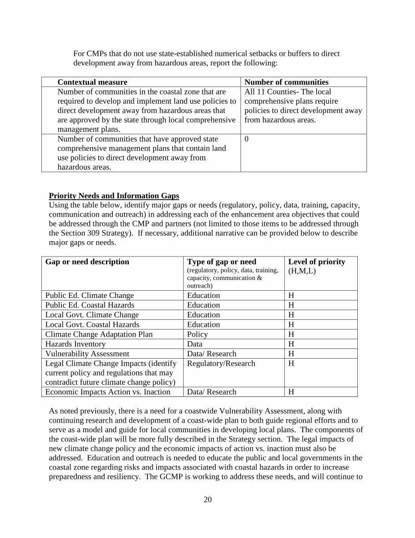
For CMPs that do not use state-established numerical setbacks or buffers to direct development away from hazardous areas, report the following:
Contextual measure Number of communities Number of communities in the coastal zone that are required to develop and implement land use policies to direct development away from hazardous areas that are approved by the state through local comprehensive management plans.
All 11 Counties- The local comprehensive plans require policies to direct development away from hazardous areas.
Number of communities that have approved state comprehensive management plans that contain land use policies to direct development away from hazardous areas.
0
Priority Needs and Information Gaps Using the table below, identify major gaps or needs (regulatory, policy, data, training, capacity, communication and outreach) in addressing each of the enhancement area objectives that could be addressed through the CMP and partners (not limited to those items to be addressed through the Section 309 Strategy). If necessary, additional narrative can be provided below to describe major gaps or needs.
Gap or need description Type of gap or need (regulatory, policy, data, training, capacity, communication & outreach)
Level of priority (H,M,L)
Public Ed. Climate Change Education H Public Ed. Coastal Hazards Education H Local Govt. Climate Change Education H Local Govt. Coastal Hazards Education H Climate Change Adaptation Plan Policy H Hazards Inventory Data H Vulnerability Assessment Data/ Research H Legal Climate Change Impacts (identify current policy and regulations that may contradict future climate change policy)
Regulatory/Research H
Economic Impacts Action vs. Inaction Data/ Research H As noted previously, there is a need for a coastwide Vulnerability Assessment, along with continuing research and development of a coast-wide plan to both guide regional efforts and to serve as a model and guide for local communities in developing local plans. The components of the coast-wide plan will be more fully described in the Strategy section. The legal impacts of new climate change policy and the economic impacts of action vs. inaction must also be addressed. Education and outreach is needed to educate the public and local governments in the coastal zone regarding risks and impacts associated with coastal hazards in order to increase preparedness and resiliency. The GCMP is working to address these needs, and will continue to

21
seek outside funding and new partnerships to assist in these efforts by developing a coastal hazards program. Enhancement Area Prioritization 1. What level of priority is the enhancement area for the coastal zone (including, but not limited
to, CZMA funding)? High _X____ Medium _____ Low _____
Briefly explain the level of priority given for this enhancement area. Preparedness for coastal hazards and sea level rise is essential for the tourism, economy and sustainability of Georgia’s natural resources. At this time our state is behind in those planning steps and is seeking the opportunity to be proactive rather than reactive.
2. Will the CMP develop one or more strategies for this enhancement area?
Yes __X___ No ______
Briefly explain why a strategy will or will not be developed for this enhancement area. In order to address the gaps and needs indicated above, a strategy will be developed to provide GCMP the resources and capacity to develop and implement a Coastal Hazards Program. As part of this strategy, the following four components will be produced: a Coastal Post Disaster Redevelopment Plan, a guidance document for local post-disaster redevelopment planning, and two pilot community plans. While the state of Georgia has not felt the impact of a major hurricane for over 100 years, the damage caused by minor hurricanes through the 1960s and 1970s illustrate the extreme level of damage that could occur in a major event. The avoidance of a major hurricane event has led to a sense of complacency among residents and officials. State coastal managers are keenly aware that the state is not immune to the potential impacts of major hurricanes and realize that it is critical to prepare the region for the possibility. This complacency, coupled with issues such as sea level rise, place Georgia’s coastal counties in a very vulnerable position. Currently, Georgia has no plan that guides local or state government agencies in addressing redevelopment after a coastal hazard event. The Coastal Hazards Strategy, which follows, will address this gap.

22
Public Access
Section 309 Enhancement Objective Attain increased opportunities for public access, taking into account current and future public access needs, to coastal areas of recreational, historical, aesthetic, ecological, or cultural value Resource Characterization Purpose: To determine the extent to which problems and opportunities exist with regard to the enhancement objective. 1. Characterize threats and conflicts to creating and maintaining public access in the coastal zone:
Type of threat or conflict causing loss of access
Degree of threat (H,M,L)
Describe trends or provide other statistics to characterize the threat and impact on access
Type(s) of access affected
Private residential development (including conversion of public facilities to private)
M The price and taxes associated with waterfront property has resulted in a need to develop/redevelop such property to its most profitable option.
Mooring for commercial fishing, general access for larger recreational boats, and mooring for transient boaters.
Non-water dependent commercial/industrial uses of the waterfront (existing or conversion)
M Traditional Working Waterfronts are declining and being replaced with different commercial activities
Loss of access for commercial fisherman
Erosion M Semidiurnal high amplitude tides cause elevated erosion rates that affect structural integrity and placement of water dependent access structures
Water access
Sea level rise/ Great Lake level change
M Sea level rise is a long-term concern b/c of the tidal range of GA’s coast
All
Natural disasters M Though GA has not experienced any large, named tropical storms in recent years, there have been storm events that have caused damage to numerous access points on both the beaches and rivers of the state.
All
National security M Possible loss of public access to expand military facilities
All

23
Encroachment on public land
L There has not been a conversion of public land at waterfronts.
Other 2. Are there new issues emerging in your state that are starting to affect public access or seem to have the potential to do so in the future?
The poor economy and shrinking state revenues have decreased available funding resulting in fewer opportunities to create, maintain, and modify public access locations.
3. (CM) Use the table below to report the percent of the public that feels they have adequate access to the coast for recreation purposes, including the following. If data is not available to report for this contextual measure, please describe below actions the CMP is taking to develop a mechanism to collect the requested data.
Contextual measure Survey data Number of people that responded to a survey on recreational access
101 responses via Internet Survey 38 responses via Mail Survey
Number of people surveyed that responded that public access to the coast for recreation is adequate or better.
68 respondents experienced problems using public access sites in GA’s coastal region
What type of survey was conducted (i.e. phone, mail, personal interview, etc.)?
Mail/Internet
What was the geographic coverage of the survey? GA’s 11 county coastal region In what year was the survey conducted? 2010 4. Briefly characterize the demand for coastal public access within the coastal zone, and the
process for periodically assessing public demand.
A survey of 139 coastal recreationists revealed the following: 49% of all respondents reported they experienced problems while trying to use public access sites in coastal Georgia. The most frequent problem experienced by site users was “Not enough parking” (66%), with “Boats blocking ramps” as the second most frequent (46%), followed by “Shore anglers blocking access” (22%). This survey or similar will be conducted every 5-years to assess demand for and satisfaction with Georgia’s coastal public access facilities.
5. Please use the table below to provide data on public access availability. If information is not
available, provide a qualitative description based on the best available information. If data is not available to report on the contextual measures, please also describe actions the CMP is taking to develop a mechanism to collect the requested data.

24
Types of public access Current number(s)
Changes since last assessment (+/-)
Cite data source
(CM) Number of acres in the coastal zone that are available for public (report both the total number of acres in the coastal zone and acres available for public access)
The total area of the coastal zone is 3,645,983 acres. The total area available for public access is ~1,219,308 acres1.
+ 11,020-acres (CELCP tracts)
DNR
(CM) Miles of shoreline available for public access (report both the total miles of shoreline and miles available for public access)
Georgia has 3,744 miles of ocean and estuarine shoreline. 93mi are ocean beach; 71.5mi of which are accessible by upland; only 17mi are accessible by car. GA has 3,651mi of estuarine shoreline. The Program is assessing public accessibility. GA is working to determine the mileage of non-estuarine - tidal fresh shoreline accessible to the public.
None DNR
1 Calculated from state WMAs, USFWS Refuges, state parks, historic sites, natural areas, National Parks/Seashore/Monuments and Ft. Stewart. Does not include estuarine acreage (e.g., marshlands, oyster reefs, etc.)

25
Types of public access Current number(s)
Changes since last assessment (+/-)
Cite data source
Number of State/County/Local parks and number of acres
8 state parks plus numerous local parks throughout the 11-coastal counties. Approximately 20,640 acres.
None Previous Assessment and DNR
Number of public beach/shoreline access sites
There are a total of 114 public access points on the three islands that have vehicle access.
+ One Glynn County Beach Access Improvement Plan; Tybee Island Beach Management Plan; and visual observation for Jekyll Island.
Number of recreational boat (power or non-power) access sites
38 boat ramps and 12 public marinas in six coastal facing counties
One marina has closed
CRD
Number of designated scenic vistas or overlook points
Numerous (located throughout the eleven county area) There is not currently a tracking mechanism
None
Number of State or locally designated perpendicular rights-of-way (i.e. street ends, easements)
Numerous (located throughout the eleven county area). There is not currently a tracking mechanism.
None
Number of fishing access points (i.e. piers, jetties)
35 public fishing piers in six coastal facing counties
+ One CRD

26
Types of public access Current number(s)
Changes since last assessment (+/-)
Cite data source
Number and miles of coastal trails/boardwalks
Approximately 358 miles of designated trails + many additional miles of undesignated canoe & bike areas available.
+ 4.25 miles trails constructed thru CIG
Previous Assessment plus trails/boardwalks known by CRD personnel to have been added.
Number of dune walkovers Approximately 55 on Tybee, St. Simons, & Jekyll Islands
+ One on Tybee CRD
Percent of access sites that are ADA compliant access
Approximately 27 of 54 (50%)
None Previous Assessment
Percent and total miles of public beaches with water quality monitoring and public closure notice programs
35.5 miles or ~ 30%
None GA Beach Water Quality Monitoring Program
Average number of beach mile days closed due to water quality concerns
0 None GA Beach Water Quality Monitoring Program
Management Characterization Purpose: To determine the effectiveness of management efforts to address those problems described in the above section for the enhancement objective. 1. For each of the management categories below, indicate if the approach is employed by the
state or territory and if significant changes have occurred since the last assessment:
Management categories Employed by state/territory (Y or N)
Significant changes since last assessment (Y or N)
Statutory, regulatory, or legal system changes that affect public access
Y N
Acquisition programs or policies
Y N
Comprehensive access management planning (including GIS data or database)
N N

27
Management categories Employed by state/territory (Y or N)
Significant changes since last assessment (Y or N)
Operation and maintenance programs
Y N
Alternative funding sources or techniques
Y N
Beach water quality monitoring and pollution source identification and remediation
Y N
Public access within waterfront redevelopment programs
N N
Public access education and outreach
Y Y
Other (please specify) 2. For management categories with significant changes since the last assessment provide the
information below. If this information is provided under another enhancement area or section of the document, please provide a reference rather than duplicate the information. a) Characterize significant changes since the last assessment; b) Specify if it was a 309 or other CZM-driven change (specify funding source) or if it was
driven by non-CZM efforts; and c) Characterize the outcomes and effectiveness of the changes.
Public Access Education and Outreach Since the last assessment, several new activities to promote and educate citizens and visitors about public access in coastal Georgia have been initiated and/or completed. First, in 2008 a GCMP Coastal Incentive Grant (CZM-driven using Section 306 funds) project resulted in the “Visitor’s Guide to Accessing Georgia’s Coastal Resources” which is essentially a “Frommer’s style” guide to public access sites within the coastal zone. This guidebook is available in hard copy or as a PDF document on the web. A FY09 Coastal Incentive Grant project (CZM-driven using Section 306 funds) developed a Coastal Georgia Blueway/saltwater paddling trail plan, which was made available to the public in print and web format. The GCMP implemented the Know the Connection public outreach and education campaign aimed at instilling in coastal citizens an appreciation of the region’s natural resources. In addition to providing information on broad number of topics, as part of the Know the Connection campaign GCMP staff has developed a model public access package that includes web-based and printed materials plus visual (kiosk style) displays describing the coastal ecosystem. These materials can be used at public access locations throughout the coast. This was also a CZM-driven change using 306 funds.

28
3. Indicate if your state or territory has a printed public access guide or website. How current is the publication and/or how frequently is the website updated? Please list any regional or statewide public access guides or websites. A public access guide was completed through a Coastal Incentive Grant, see #2 above. There are no plans to update the guide at this time. The Coastal Resources Division provides an online version of boating access locations on the coast and are updated periodically (http://crd.dnr.state.ga.us/content/displaynavigation.asp?TopCategory=125).
Priority Needs and Information Gaps Using the table below, identify major gaps or needs (regulatory, policy, data, training, capacity, communication and outreach) in addressing each of the enhancement area objectives that could be addressed through the CMP and partners (not limited to those items to be addressed through the Section 309 Strategy). If necessary, additional narrative can be provided below to describe major gaps or needs.
Gap or need description Type of gap or need (regulatory, policy, data, training, capacity, communication & outreach)
Level of priority (H,M,L)
Funding to create and maintain public access, including land acquisition
Funding
M
Need mechanism to track publicly accessible marsh acreage for CM; e.g., draw polygon around access sites and measuring marsh acreage within polygon (e.g. 5-mile radius)
Capacity to measure M
Enhancement Area Prioritization 1. What level of priority is the enhancement area for the coastal zone (including, but not limited
to, CZMA funding)? High _____ Medium __M___ Low _____ Briefly explain the level of priority given for this enhancement area. Public accessibility to the many natural resources the Georgia coast has to offer is a priority to the GCMP. There is, at this time, adequate access to and less intense pressure on those current sites. There will be continued work on developing new sites and maintaining existing access sites, but increased efforts will not be employed.
2. Will the CMP develop one or more strategies for this enhancement area?
Yes ______ No ___X___

29
Briefly explain why a strategy will or will not be developed for this enhancement area. A strategy will not be developed for Public Access at this time. Currently, other programs within Coastal Resources Division are addressing boating and fishing access. Beach access is not an issue currently due to numerous access points. The GCMP is adequately staffed to address the current public access issues and is not foreseen that additional support will be necessary within the next five years.
30
Marine Debris
Section 309 Enhancement Objective Reducing marine debris entering the Nation's coastal and ocean environment by managing uses and activities that contribute to the entry of such debris Resource Characterization Purpose: To determine the extent to which problems and opportunities exist with regard to the enhancement objective. 1. In the table below, characterize the significance of marine/Great Lakes debris and its impact
on the coastal zone.
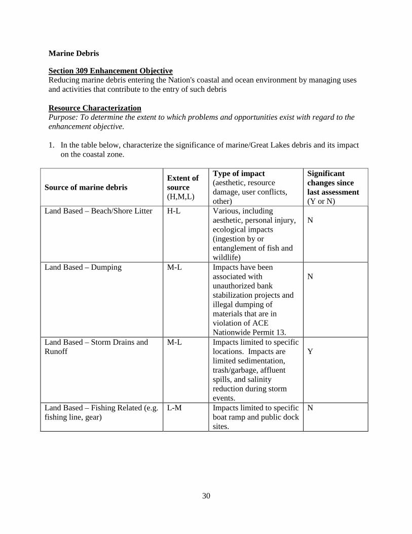
Source of marine debris Extent of source (H,M,L)
Type of impact (aesthetic, resource damage, user conflicts, other)
Significant changes since last assessment (Y or N)
Land Based – Beach/Shore Litter H-L Various, including aesthetic, personal injury, ecological impacts (ingestion by or entanglement of fish and wildlife)
N
Land Based – Dumping M-L Impacts have been associated with unauthorized bank stabilization projects and illegal dumping of materials that are in violation of ACE Nationwide Permit 13.
N
Land Based – Storm Drains and Runoff
M-L Impacts limited to specific locations. Impacts are limited sedimentation, trash/garbage, affluent spills, and salinity reduction during storm events.
Y
Land Based – Fishing Related (e.g. fishing line, gear)
L-M Impacts limited to specific boat ramp and public dock sites.
N
31
Source of marine debris Extent of source (H,M,L)
Type of impact (aesthetic, resource damage, user conflicts, other)
Significant changes since last assessment (Y or N)
Ocean Based – Fishing (Derelict Fishing Gear)
H-M Type of impacts can vary – destruction of salt marsh, impacts to former and current commercial docks, degradation of habitat, navigational hazards, threatening human safety, and ruining aesthetics.
N
Ocean Based – Derelict Vessels H-M Type of impact can vary – leaking pollutants such as oil and other toxins; creating navigational hazards; degrading habitat; destruction of salt marsh; entrapping animals and nesting birds; financial burden to local government; threatening human safety; and ruining aesthetics.
Y
Ocean Based – Vessel Based (cruise ship, cargo ship, general vessel)
M Impacts are limited to specific areas such as Savannah and Brunswick; these impacts include prop agitation, impacts to fisheries, sewage spills, and litter.
N
Hurricane/Storm H-M Impacts are dependent upon storm strength and storm surge. Potential damage could cripple economic, environmental, human, and wildlife.
N

32
Source of marine debris Extent of source (H,M,L)
Type of impact (aesthetic, resource damage, user conflicts, other)
Significant changes since last assessment (Y or N)
Other (please specify) Abandoned & derelict vessels used as abodes
H Impacts to water quality from sewage release within the 3-mile limit, littering, increase in derelict vessels, increase in criminal activity along and near the waterway, water hazards, and general marine debris.
Y
Other (please specify) Water related structures.
H-M
Dilapidated piers, private recreational docks, & marinas are on the rise. Chatham County has a large number of older dock structures that pose a significant threat to navigation and boater safety.
Y
2. If information is not available to fill in the above table, provide a qualitative description of
information requested, based on the best available information. 3. Provide a brief description of any significant changes in the above sources or emerging
issues. Land Based The development of the Coastal Stormwater Supplement in 2009 has resulted in a significant increase in the potential for coastal communities to manage their stormwater runoff and meet state and federal permitting requirements. See also: Cumulative and Secondary Impacts. Derelict Vessels The declining commercial fishing industry and the aging commercial fishing fleet in Georgia is contributing to the increase in marine debris from sunken and abandoned vessels, rigging, nets, cables, etc. Some of the vessels still have fuel on board and require post spill cleanup. Owners often cannot be found or when found they do not have the financial ability to clean up or dispose of the vessel. Most, if not all of the abandoned or derelict vessels do not have insurance. 73% of all of the potential marine debris contributing vessels are commercial, 14% are barges that are being used for construction purposes, and the remaining 13% are private recreational watercraft. (Source: GA DNR/CRD, 2010.) The extent to which derelict vessels are an issue in coastal Georgia became known with the establishment of the Compliance and Enforcement Section in late 2006.
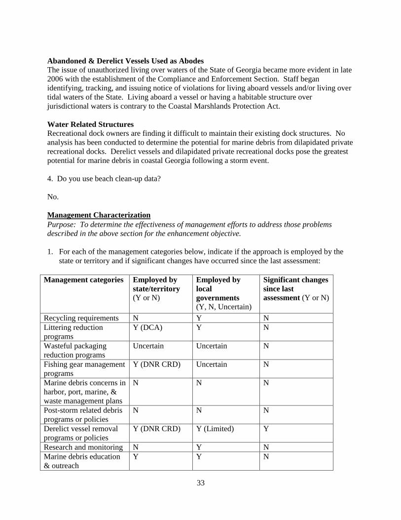
33
Abandoned & Derelict Vessels Used as Abodes The issue of unauthorized living over waters of the State of Georgia became more evident in late 2006 with the establishment of the Compliance and Enforcement Section. Staff began identifying, tracking, and issuing notice of violations for living aboard vessels and/or living over tidal waters of the State. Living aboard a vessel or having a habitable structure over jurisdictional waters is contrary to the Coastal Marshlands Protection Act. Water Related Structures Recreational dock owners are finding it difficult to maintain their existing dock structures. No analysis has been conducted to determine the potential for marine debris from dilapidated private recreational docks. Derelict vessels and dilapidated private recreational docks pose the greatest potential for marine debris in coastal Georgia following a storm event. 4. Do you use beach clean-up data? No. Management Characterization Purpose: To determine the effectiveness of management efforts to address those problems described in the above section for the enhancement objective. 1. For each of the management categories below, indicate if the approach is employed by the
state or territory and if significant changes have occurred since the last assessment:
Management categories Employed by state/territory (Y or N)
Employed by local governments (Y, N, Uncertain)
Significant changes since last assessment (Y or N)
Recycling requirements N Y N Littering reduction programs
Y (DCA) Y N
Wasteful packaging reduction programs
Uncertain Uncertain N
Fishing gear management programs
Y (DNR CRD) Uncertain N
Marine debris concerns in harbor, port, marine, & waste management plans
N N N
Post-storm related debris programs or policies
N N N
Derelict vessel removal programs or policies
Y (DNR CRD) Y (Limited) Y
Research and monitoring N Y N Marine debris education & outreach
Y Y N

34
Management categories Employed by state/territory (Y or N)
Employed by local governments (Y, N, Uncertain)
Significant changes since last assessment (Y or N)
Other (please specify) Marina Inspections
Y (DNR CRD) N Y
2. For management categories with significant changes since the last assessment provide the
information below. If this information is provided under another enhancement area or section of the document, please provide a reference rather than duplicate the information. a) Characterize significant changes since the last assessment; b) Specify if it was a 309 or other CZM-driven change (specify funding source) or if it was
driven by non-CZM efforts; and c) Characterize the outcomes and effectiveness of the changes.
Derelict Vessel Removal In 2005, GCMP initiated an abandoned, sunken, and derelict vessel program. The State Legislature funded the program for two years (2007 and 2008). $180,000.00 per year was provided to the program to identify, map, prioritize, and remove derelict and sunken vessels. 180 vessels have been mapped to date and the program removed 10 vessels with state appropriated monies. 40 vessels have been removed by direct involvement of GCMP staff with the owner, insurance company, or a third party. A product of the sunken vessel removal program was the creation of an online web based tracking system that can be accessed through the Georgia DNR website (www.gadnr.org). The vessel removal program was gaining strength and had the potential to limit the “creation” of marine debris, reduce hazards, and improve Georgia’s waterways. In 2007 the Abandoned Vessel Act was enacted and allowed for vessels to be declared abandoned after being left unattended for five (5) or more days. The Act has not been fully utilized because of the lack of funding due to the recent economic downturn. The sunken vessel removal efforts are currently CZM-driven and funded by the GCMP, Section 306, under Compliance and Enforcement Program duties. Staff updates mapping, conducts inspections and owner-notification procedures and engages in negotiation with owners for removal of sunken vessels. Marina Inspections A 309 strategy (2006-2011) to develop and implement a Compliance and Enforcement Program for the GCMP’s direct permit authority included the development of a system of routine marina inspections. These inspections ensure that marinas are adhering to permit conditions for size, location, and management, including marine debris. This was a CZM-driven change using 309 funds. Priority Needs and Information Gaps Using the table below, identify major gaps or needs (regulatory, policy, data, training, capacity, communication and outreach) in addressing each of the enhancement area objectives that could be addressed through the CMP and partners (not limited to those items to be addressed through the Section 309 Strategy). If necessary, additional narrative can be provided below to describe major gaps or needs.

35
Gap or need description Type of gap or need (regulatory, policy, data, training, capacity, communication & outreach)
Level of priority (H,M,L)
Recreational boater responsibility Outreach H Commercial boater responsibility Outreach H Structures (piers, docks) and derelict vessels
Regulatory/Outreach/Funding H
Continuing education and public outreach is needed to combat marine debris caused by recreational and commercial boaters. In addition funding is needed to support removal of derelict and abandoned vessels that contribute to the marine debris problem. State funding for this work was cut two years ago. Enhancement Area Prioritization
1. What level of priority is the enhancement area for the coastal zone (including, but not limited to, CZMA funding)?
High __X__ Medium _____ Low _____ Briefly explain the level of priority given for this enhancement area.
Addressing marine debris issues specifically related to the management of derelict and sunken vessels and dilapidated dock and pier structures is a high priority for the GCMP and coastal local governments. Very little funding from state or federal sources is available to assist the state in addressing these ongoing issues.
2. Will the CMP develop one or more strategies for this enhancement area?
Yes ______ No __X___
Briefly explain why a strategy will or will not be developed for this enhancement area. During the last decade, intensive development has occurred in Georgia’s coastal zone. This includes development of flood and storm surge susceptible properties. These susceptible developments have placed more people and property at risk to coastal hazards. Further, these susceptible developments have degraded the surrounding area by interfering with the natural marshland’s ability to protect the human environment from severe hazard events. Roads, docks, and cleared land diminished the natural buffers that wetlands and marshes provide. Large piers and docks can serve as a conduit to facilitate storm surge over sea walls. Sunken and derelict vessels, old piers, docks, and floating structures will be a significant form of debris following a major storm event. The development of a 309 strategy under Coastal

36
Hazards will address policies or processes necessary for dealing with structures, docks, and derelict vessels in a post storm environment.

37
Cumulative and Secondary Impacts (CSI)
Section 309 Enhancement Objective Development and adoption of procedures to assess, consider, and control cumulative and secondary impacts of coastal growth and development, including the collective effect on various individual uses or activities on coastal resources, such as coastal wetlands and fishery resources. Resource Characterization Purpose: To determine the extent to which problems and opportunities exist with regard to the enhancement objective. 1. Identify areas in the coastal zone where rapid growth or changes in land use require improved management of CSI since the last assessment. Provide the following information for each area:
Geographic area Type of growth or change in land use
Rate of growth or change in land use (%change, average acres converted, H, M, L)
Types of CSI
Forestry/timber lands
Increase in conversion to residential/ commercial development in large tracts
H Loss of habitat, increased erosion and sediment runoff into coastal streams and rivers, increase in nonpoint source runoff from additional impervious surfaces, change in water table with removal of forested areas
Coastal counties Residential development – sprawl patterns utilizing traditional subdivision design
H-M Increased impervious surface and subsequent NPSP, loss of habitat, increased demand on drinking water supply and other infrastructure demands
Between 1980 and 2000, Georgia’s coastal population grew by about 18%, and it is predicted that by 2030, coastal Georgia will see a 50% increase in population (Georgia Tech Center for Quality Growth & Regional Development, 2006). Current development patterns that accommodate such growth are sprawling in nature and tend to be prevalent in more sensitive areas. With nine of coastal Georgia’s 13 major barrier islands unavailable for development,

38
pressure is focused on marshfront property, back barrier islands (also known as marsh hammocks) and former commercial timberlands. This pattern is especially troublesome because of the potential impacts on water quality from stormwater and septic system infiltration into coastal marshlands when developments are placed outside the reaches of existing water and sewer infrastructure. Development in coastal Georgia has been increasing over the past decade until the recent economic downturn. Once the economy recovers development in the coastal region is expected to rapidly increase. If these current development patterns continue, the region will experience significant impacts to the natural resources through habitat loss and fragmentation, nonpoint source and point source pollution, and increase demand on water supply. The current trends also show an increase in forestry and timberland conversion from commercial forestry to residential or commercial development. This trend will have environmental impacts as extremely large tracts are being sold at once, drastically changing the habitat and site hydrology over large areas. 2. Identify sensitive resources in the coastal zone (e.g., wetlands, waterbodies, fish and wildlife habitats, critical habitat for threatened and endangered species) that require a greater degree of protection from the CSI of growth and development. If necessary, additional narrative can be provided below to describe threats.
Sensitive Resources
CSI threats description Level of threat (H, M, L)
Wetlands Increase in fill of isolated wetlands, increase in built structures in the marsh
H
Coastal Rivers
Increase in sediment loads and other pollutant sources; also changes in instream flow from inland uses
H
Aquifers Increase in development and demand on drinking water supply H River Corridors
Eroding shorelines, loss of natural buffers, floodplain alterations H
Rural Counties
As coastal population continues to increase, additional pressure will be placed on rural counties with land available for development. Beginning to see forestry lands converted to residential and commercial development – large tracts being sold at one time.
H
Non-native and invasives
Loss of native habitat from sprawl development, increase in invasive species found in coastal region
M
Ocean Shorelines
Exposed to high hazards M
Management Characterization Purpose: To determine the effectiveness of management efforts to address those problems described in the above section for the enhancement objective. 1. For each of the management categories below, indicate if the approach is employed by the state and if significant changes have occurred since the last assessment:
Management Categories Employed by state (Y/N) Significant changes (Y/N)

39
Regulations N N Policies N N Guidance Y Y Management Plans
N N
Research, assessment, monitoring Y Y Mapping N N Education and outreach Y Y Other 2. For management categories with significant changes since the last assessment provide information below. If this information is provided under another enhancement area or section of the document, please provide a reference rather than duplicate the information. a) Characterize changes;
b) Specify if 309, other CZM driven change or non-CZM driven (specify funding source) or if it was driven by non-CZM efforts; and
c) Characterize outcomes and effectiveness of changes Guidance • In 2005-2006, the Coastal Green Growth Guidelines were published to serve as a guide for
environmentally sensitive development in Georgia’s coastal zone. The Coastal Green Growth Guidelines are primarily oriented for the developers and builders. Often, local government standards and ordinances do not allow for this type of flexible, innovative environmental design. In response to this challenge, the GCMP funded a project, using 306 funds, to create a package of companion ordinances to the Coastal Green Growth Guidelines. Local coastal governments use these model ordinances to create development regulations and standards that are tailored to the individual needs of each community and the unique aspects of coastal Georgia. These model ordinances tie together existing model coastal ordinances that have been developed for the Coastal and Statewide Nonpoint Source and Coastal Management Programs, including ordinances for riparian buffers, wetlands, conservation subdivisions and septic system maintenance and inspection.
The GCMP has also funded an addition to the Green Growth Guidelines to include a chapter on the economic benefits of developing according to the manual. This addition included online tools for developers and homeowners that show the change in property/home value as several factors are changed including % community greenspace and % impervious cover. This was also CZM-driven using 306 funds.
• Beginning in 2006, the Environmental Protection Division (EPD) of the Georgia Department
of Natural Resources, in conjunction with multiple sister agencies and organizations identified the need to address stormwater management in coastal Georgia. This effort was driven in part by ongoing dialogues in coastal issue stakeholder groups about resource degradation resulting from stormwater runoff. Additionally, Georgia, along with other states with approved Coastal Management Programs, is required to implement best management practices to protect coastal resources from nonpoint source pollution.

40
A multi-faceted grant project was designed and carried out by EPD, the Center for Watershed Protection, the Savannah-Chatham Metropolitan Planning Commission, the local governments included in a 24 county coastal plain region as well as many private companies and organizations. Products produced include: • Coastal Stormwater Supplement to the Georgia Stormwater Management Manual • Corresponding excel spreadsheet to ensure a project's consistency with the Coastal
Supplement • Coastal Model Stormwater Ordinance • Stormwater Utility Manual for local governments • Stormwater Monitoring BMP Protocol
The Coastal Stormwater Supplement to the Georgia Stormwater Management Manual provides Georgia’s coastal communities with comprehensive guidance on an integrated, green infrastructure-based approach to natural resource protection, stormwater management and site design that can be used to better protect coastal Georgia’s unique and vital natural resources from the negative impacts of land development and nonpoint source pollution. In step with the national trend, the focus of the Supplement shifts post-construction stormwater management efforts to the prevention of stormwater runoff. While this was not a CZM driven project, 306 program funding was contributed through GCMP technical staff participation and implementation guidance.
• The Regional Plan of Coastal Georgia was funded in part by the Georgia Department of
Community Affairs. This was not a CZM-driven change, but the GCMP provided 306 funding and technical staff support throughout project development. Under the leadership of the Coastal Regional Commission Council, with direction from the Restructuring Committee, and participation of coastal cities and counties, stakeholders, partners and other regional leaders, the Regional Plan empowers government officials and policy makers to usher in sustainable behavior and practices during the next twenty years. The Regional Plan of Coastal Georgia provides guidance to regional and business leaders, local government, state and federal agencies, and citizens as they help shape coastal Georgia‘s future. The Regional Plan, which identifies opportunities and challenges facing the region, is the result of a comprehensive review and analysis of land development trends and patterns in coastal Georgia’s 10 counties and 35 municipalities. The Regional Agenda, the most important part of the Regional Plan, includes the region-wide vision for the future, its guiding principles, key issues and opportunities, performance standards, and the implementation program. The Regional Plan is currently in the implementation phase and GCMP staff continues to provide input to the project.
Research, Assessment, Monitoring • The Georgia Department of Community Affairs (DCA) provided funding to jumpstart the
implementation of the Regional Plan of Coastal Georgia. In November of 2008, Thomas & Hutton Engineering of Savannah and Post, Buckley, Schuh & Jernigan, Inc (PBS&J) were awarded a contract to conduct a region-wide water, sewer, and stormwater inventory. The
41
purpose of the inventory was to compile information about this type of infrastructure to begin the process of examining growth patterns and trends.
At the same time, Jordan, Jones & Goulding, Inc., (JJ&G) of Norcross was awarded a contract to conduct a transportation assessment for the ten-county region. The purpose of the assessment was to examine all previous transportation studies and recommendations, and assess whether the existing and planned transportation system can adequately address the current and future regional mobility needs of the region. This was driven by non-CZM efforts.
• The GCMP also funds projects annually through the Coastal Incentive Grant Program, using
306 funds. There have been several grants that have funded research to study the cumulative and secondary impacts of development in coastal Georgia. Examples of projects include funding the Georgia Coastal Research Council, a Field Assessment and Simulation of Shading from Alternative Dock Construction Materials, Sea Level Rise in Coastal Georgia, Quantifying the Impact of Recreational and Commercial Usage of the Atlantic Intracoastal Waterway on the Natural Resources of Georgia, Master Plan for Future Growth and Development for the City of Riceboro, Development of Future Land Use Plan and Local Ordinances for Brantley County, Coastal GA Green Developer Program: Phase II, and Employing Nonpoint Education for Municipal Officials (NEMO) Outreach Training to Inform Local Decision Makers About Effective Alternative Land Use Initiatives, Including Smart Growth, to Improve Coastal Georgia Water Quality. Results of several grants have been presented at Brownbag presentations, Coastal Advisory Council meetings and other presentations.
Education and Outreach • In 2009, the Education, Outreach, and Technical Assistance Program of the Coastal Regional
Commission presented the Practicum Series. Its purpose was to assist local governments in adopting best management practices and in addressing specific deficiencies. This was driven by non-CZM efforts.
• The GCMP continues to fund and enhance the education campaign; "Know the Connection"
in an effort to better convey information concerning our coastal natural world. New salt marsh interpretive displays have been constructed, and new educational materials continue to be developed and made available to the general public, scientific community, coastal managers and local governments. This is CZM-driven using 306 funds.
Priority Needs and Information Gaps
Gap or need description Type of gap or need (regulatory, policy, data, training, capacity, communication & outreach)
Level of Priority (H, M, L)
Capacity to address CSI at state and local level
Communication & outreach, regulatory, training and capacity
H
Assessment of success of stormwater management
Research and data collection H

42
guidelines Ability to measure CSI and document change
Data, training H
While the GCMP has been successfully working with local governments over the past five years, there continues to be a growing need for addressing CSI at the local level through local ordinances and community programs. Some communities have adopted ordinances to address CSI such as stormwater ordinances, conservation subdivision ordinances and wetlands protection ordinances, but other communities lack the funding and staff to develop and implement new ordinances in-house. In these types of communities (counties and incorporated cities/towns), it is imperative that they receive training and capacity building opportunities as they become available. The GCMP has provided this assistance in several communities through Coastal Incentive Grants (306 funding) and technical assistance, but additional long-term capacity building and training is continuously needed throughout the region. There is also a need to assess the success of current and proposed stormwater management guidelines to evaluate their success and ease of implementation. There is also a need to develop a systematic approach to tracking, measuring, and documenting CSI throughout coastal Georgia. This data could then be used for management, policy and training purposes, particularly in identifying CSI trends over time. Enhancement Area Prioritization 1. What level of priority is the enhancement area for the coastal zone (including, but not limited to, CZMA funding)?
High __X____ Medium _______ Low _______
Briefly explain the level of priority given for this enhancement area. The need to protect Georgia’s coastal resources from cumulative and secondary impacts of coastal growth and development continues to be a priority. The GCMP has made a significant effort to identify the gaps and needs in our communities through ordinance audits and a Needs Assessment conducted in 2006. The GCMP has also funded initiatives to address CSI such as low impact development model ordinances and quantifying the economic benefits of green development. GCMP staff has used the results of these efforts to provide targeted training and outreach through the technical assistance program. 2. Will the CMP develop one or more strategies for this enhancement area?
Yes _____ No __X__

43
Briefly explain why a strategy will or will not be developed for this enhancement areas. A strategy will not be developed for this enhancement area at this time. GCMP staff will continue to provide targeted training and outreach to local governments and continue to fund research and projects that will provide tools for local communities to use in addressing this issue. As the GCMP develops its capacity to administer these tools and programs, a strategy may be developed in the future to quantify the benefits of these programs and identify new gaps that could be addressed with a different approach.

44
Special Area Management Planning
Section 309 Enhancement Objective Preparing and implementing special area management plans for important coastal areas
The Coastal Zone Management Act (CZMA) defines a Special Area Management Plan (SAMP) as “a comprehensive plan providing for natural resource protection and reasonable coastal-dependent economic growth containing a detailed and comprehensive statement of policies; standards and criteria to guide public and private uses of lands and waters; and mechanisms for timely implementation in specific geographic areas within the coastal zone. In addition, SAMPs provide for increased specificity in protecting natural resources, reasonable coastal-dependent economic growth, improved protection of life and property in hazardous areas, including those areas likely to be affected by land subsidence, sea level rise, or fluctuating water levels of the Great Lakes, and improved predictability in governmental decision making."
Resource Characterization Purpose: To determine the extent to which problems and opportunities exist with regard to the enhancement objective. 1. Identify geographic areas in the coastal zone subject to use conflicts that can be addressed
through special area management plans (SAMP). Also include areas where SAMP have already been developed, but new issues or conflicts have developed that are not addressed through the current plan. If necessary, additional narrative can be provided below.
Geographic Area Major conflicts
Is this an emerging or a long-standing conflict?
Marsh Hammocks/Barrier Island
Potential Development Long-standing
Shellfish Areas WQ degradation Long-standing Riparian Corridors WQ degradation Long-standing Developed beachfronts Coastal hazards/Sand
Management/Retreat Long-standing
Working Waterfronts Culture loss Emerging St. Mary’s River WQ Degradation Emerging Port of Savannah Business, harbor deepening,
WQ concerns, Invasive species Long-standing
Flood Prone Areas Development Long-standing Ocean Resources Resource management and
protection Emerging

45
Management Characterization Purpose: To determine the effectiveness of management efforts to address those problems described in the above section for the enhancement objective. 1. Identify below any special management areas in the coastal zone for which a SAMP is under
development or a SAMP has been completed or revised since the last Assessment:
SAMP title Status (new, revised, or in progress)
Date approved or revised
N/A 2. For management categories with significant changes since the last assessment provide the
information below. If this information is provided under another enhancement area or section of the document, please provide a reference rather than duplicate the information. a) Characterize significant changes since the last assessment (area covered, issues addressed
and major partners); b) Specify if it was a 309 or other CZM-driven change (specify funding source) or if it was
driven by non-CZM efforts; and c) Characterize the outcomes and effectiveness of the changes.
Priority Needs and Information Gaps Using the table below, identify major gaps or needs (regulatory, policy, data, training, capacity, communication and outreach) in addressing each of the enhancement area objectives that could be addressed through the CMP and partners (not limited to those items to be addressed through the Section 309 Strategy).
Gap or need description Type of gap or need (regulatory, policy, data, training, capacity, communication & outreach)
Level of priority (H,M,L)
Water Quality Data, capacity, outreach H Zoning – Hazard/Conservation Policy H Personnel for implementation Capacity H Water quality is an ongoing concern in coastal Georgia. Additional research and the capacity to model impacts of certain activities on coastal water bodies is an ongoing need. In response to findings of impacts, new policies may be needed at the state and local level to address these impacts and protect coastal water quality in the future. There is also a continuous need for local governments to address these issues through local policies such as zoning and other ordinances. Also, implementation of any new policy will require an increase in capacity through personnel and training. Enhancement Area Prioritization 1. What level of priority is the enhancement area for the coastal zone (including, but not limited
to, CZMA funding)?

46
High _____ Medium __X___ Low _____ Briefly explain the level of priority given for this enhancement area.
The current pressure of development in some of the areas is not significant enough yet to warrant the development of a SAMP. Efforts are underway to assist local governments in addressing future development issues. One of the efforts includes collaboration with the Coastal Regional Commission to implement the new Coastal Stormwater Supplement in order to address stormwater runoff and non-point pollution. The GCMP also continues to update and provide assistance with the Green Growth Guidelines that was developed for coastal communities and developers. Water quality protection efforts are also attained through conservation by oversight of the Coastal and Estuarine Land Conservation Program and the Coastal Georgia Land Conservation Initiative. The Savannah Harbor Expansion and issues surrounding the port are long standing. The Stakeholder Evaluation Group (SEG) was formed to address critical issues concerning port expansion several years ago. The GCMP is considered a stakeholder and staff provides expertise and input to the SEG. The draft Environmental Impact Statement was released in November 2010 and is currently under review. Development on marsh hammocks and barrier islands has also been an ongoing issue. The hammocks serve as critical habitat areas as well as lessen impacts to the mainland from storms. Water quality degradation and habitat loss are the primary impacts from development on the hammocks. A Coastal Marsh Hammocks Advisory Council was appointed in 2001 and their efforts led to the report titled “Facilitating Human Dimensions Research On the Future Management Of Coastal Marsh Hammock Development” in 2003. The report outlined recommendations for the Department of Natural Resources to consider. The Department and GCMP continue to work towards protection of hammocks but certain issues are persistent and yet unresolved. Retention of culture and working waterfronts is an emerging issue that is currently being addressed through the Coastal Incentive Grant Program process as communities develop their own vision for local waterfront communities. Identification and protection of areas particularly susceptible to coastal hazards such as beachfront communities and flood prone areas is a focus of local and regional agencies. Workshops have been conducted to provide local communities with the necessary tools to plan for hazards. Furthermore, the GCMP has served as a partner and provided funding for much needed elevation data through a coastal LiDAR dataset. In order to more comprehensively address this issue the GCMP will pursue a 309 Coastal Hazards Strategy. Ocean Resources is an emerging issue in Georgia. There are individual ongoing efforts addressing resource management such as fishery management and protection of endangered and threatened species. However there has not been a concerted effort to address ocean resources

47
from an ecosystem based management approach. Emerging issues such as energy exploration and siting, increased shipping traffic, and military operations have emphasized the need for a comprehensive marine spatial management plan. The GCMP will approach ocean resources under the section 309 Ocean Resources Strategy. The GCMP provides input and expertise concerning the areas listed, but has not determined the need for development of a SAMP at this point. 2. Will the CMP develop one or more strategies for this enhancement area?
Yes ______ No ___X___ Briefly explain why a strategy will or will not be developed for this enhancement area.
Several enhancement areas have overlapping impacts that have been already recognized by the GCMP, and are being addressed by existing GCMP efforts or through partnerships. Certain emerging issues such as ocean planning and coastal hazards are being addressed through other 309 strategies. Addressing emerging issues within previously discussed strategies, rather than through creation of a SAMP, allows for greater flexibility and coordination within the GCMP and its partnerships. The current need for Ocean Resource planning is to begin the discussions, acquisition of data, and policy review and recommendations. Therefore it is not applicable at this time to proceed with a SAMP for ocean resources without more information. There is similar reasoning for Coastal Hazards because the coastal communities and the State are at different stages of planning.

48
Ocean/Great Lakes Resources
Section 309 Enhancement Objective Planning for the use of ocean resources Resource Characterization Purpose: To determine the extent to which problems and opportunities exist with regard to the enhancement objective. 1. In the table below characterize ocean and/or Great Lakes resources and uses of state concern, and specify existing and future threats or use conflicts.
Resource or use Threat or use conflict
Degree of threat (H,M,L)
Anticipated threat or use conflict
Energy Endangered species impacts/Coastal disturbance from associated infrastructure
L H
Sand Management Sand sharing/Coastal Hazards protection
M M
Recreation Human interactions /interface with wildlife
M M
Commercial Fishing Stock depletion, Economic impact
H H
Military Endangered Species interface
M H
Shipping/Ports Invasives/Economics/endangered species
M M
2. Describe any changes in the resources or relative threat to the resources since the last assessment.
Energy In 2007, the Georgia Institute of Technology partnered with Southern Company to conduct a detailed review of wind data, siting options and issues, regulatory issues, and the technology. An economic analysis was also conducted as a part of the project. The report entitled “Southern Winds” noted the potential for “class 4” winds at two general locations off of Georgia’s coast – Tybee Island and Jekyll Island. The full report may be found at: http://www.energy.gatech.edu/partnerships/Southern%20Winds%20Summary%20Report.pdf Since the issuance of this report, Southern Company has made known its intentions to submit proposal to the Bureau of Ocean Energy Management, Regulation and Enforcement (formerly MMS) for up to three experimental leases to install meteorological (met) tower(s) in federal waters off of Tybee Island. These towers would be used to collect wind speed data to ascertain the viability of offshore wind turbines for commercial power generation. It is reasonable to expect that these met towers will be installed within the next 5 years. Any subsequent installation

49
of offshore wind-farms, however, still remains 10-20 years in the future. More information on energy siting can be found in the Energy and Government Facility Siting Assessment. Potential installation of wind turbines of the Georgia Coast could have impacts on endangered marine species known to the area such as Right Whales and sea turtles. Installation, operation, increased boat traffic, and infrastructure can lead to more numerous interactions with coastal marine species. Associated infrastructure of offshore energy can lead to greater disturbance than the actual generating footprint itself. Transmission lines will need to be put into place across the sea floor and make their way to land where the power can be distributed. Georgia has several preserved barrier islands and thousands of acres of marsh that would have to be crossed depending upon where the transmission lines come ashore. The infrastructure potentially poses a threat to the marsh and important barrier islands.
Sand Management Two shipping channels along the Georgia coast cut off the sand sharing system to down- drift islands affecting developed beachfronts. Currently, only Tybee Island and Sea Island renourish their beaches. The Corps of Engineers has responsibilities for the Shore Protection Project on Tybee Island while Sea Island is a privately funded recurring renourishment. House Bill 727, passed in 2004, addresses nearshore placement of suitable dredged materials. The GCMP underwent a program change in 2005 to incorporate HB 727 under the Program’s enforceable policies. Since that time the Program has been working with the U.S. Army Corps of Engineers and the City of Tybee Island on sediment placement and disposal. In April of 2008 the U.S. Army Corps of Engineers released a report titled “Impact of Savannah harbor Deep Draft Navigation Project on Tybee Island Shelf and Shoreline’ which states the extent of the impact to Tybee Island from the harbor channel. Since then the Corps has been working on a study for possible mitigation. The Savannah Harbor Deepening project released the Environmental Impact Statement in November of 2010. GCMP has submitted comments on the project.
Recreation With growth along the Coast, there are more people utilizing the resources for recreation resulting in more interactions with wildlife. Interactions such as dolphin feeding, approaching of Right whales, sea turtle and manatee boat strikes all pose risks to the coastal species.
Commercial Fishing Commercial fishing is a livelihood for many coastal Georgia residents. Currently the Red Snapper fishery is closed off the Georgia coast to protect the future of the stocks. While important for stock protection it has caused a hardship for many commercial fishermen. The commercial fishing industry supports several of the working waterfronts on the coast as well as supports local and state economies. Given the closure and future of commercial fishing off the coast this category is given a high degree of threat and future conflict.

50
Military The Georgia Coast is home to Fort Stewart Army Base, Hunter Army Airfield, Townsend Bombing Range, and Kings Bay Naval Submarine Base. The Navy is exploring potential areas off the Georgia and Florida coasts for undersea warfare training grounds. Sonar, used in training might have an effect on migrating Right whales depending upon location and time of year. There are currently older Naval towers offshore that designated areas for flight training. The military also utilizes portions of the airspace for maneuvers at the Townsend Bombing Range.
Shipping/Ports Negotiations concerning the deepening of the Savannah River have been longstanding. The Environmental Impact Statement was released in November of 2010 for public comment. The GCMP has submitted comments. The dredging may pose a threat to water quality (DO, salinity) and have negative impacts on the estuary. Increased traffic and larger ships pose strike risks to endangered species such as the Right whale and sea turtles. Release of ballast water increases the threat of invasive species. Slower speed limits have been placed on commercial shipping but increased numbers and size of ships have the potential for more incidents. Management Characterization Purpose: To determine the effectiveness of management efforts to address those problems described in the above section for the enhancement objective. 1. For each of the management categories below, indicate if the approach is employed by the
state or territory and if significant changes have occurred since the last assessment:
Management categories
Employed by state/territory (Y or N)
Significant changes since last assessment (Y or N)
Comprehensive ocean/Great Lakes management plan or system of Marine Protected Areas
N N
Regional comprehensive ocean/Great Lakes management program
N N
Regional sediment or dredge material management plan
Y N
Intra-governmental coordination mechanisms for Ocean/Great Lakes management
N N
Single-purpose statutes related to ocean/Great Lakes resources
N N
Comprehensive ocean/Great Lakes management statute
N N
Ocean/Great Lakes resource mapping or information system
N N
Ocean habitat research, assessment, or monitoring programs
Y N
Public education and outreach efforts Y N Other (please specify)

51
2. For management categories with significant changes since the last assessment provide the
information below. If this information is provided under another enhancement area or section of the document, please provide a reference rather than duplicate the information. a) Characterize significant changes since the last assessment; b) Specify if it was a 309 or other CZM-driven change (specify funding source) or if it was
driven by non-CZM efforts; and c) Characterize the outcomes and effectiveness of the changes.
Priority Needs and Information Gaps Using the table below, identify major gaps or needs (regulatory, policy, data, training, capacity, communication and outreach) in addressing each of the enhancement area objectives that could be addressed through the CMP and partners (not limited to those items to be addressed through the Section 309 Strategy). If necessary, additional narrative can be provided below to describe major gaps or needs.
Gap or need Description Type of gap or need (regulatory, policy, data, training, capacity, communication & outreach)
Level of priority (H, M, L)
Increased governmental coordination Management H Energy siting Policy H Resource mapping and siting Data H Mapping, energy systems, spatial planning
Training H
Personnel to adequately address conflicts Capacity H Identification of stakeholders and involvement
Education & outreach H
Increased governmental coordination for ocean resource planning is an ongoing need. Many ocean resources cross state and regional boundaries and a coordinated approach to managing these resources is extremely important. There is also a lack of current policy in place to address and guide issues associated with energy siting (offshore and onshore components). As spatial planning initiatives begin to move forward, there is an anticipated need for training and capacity building within the associated agencies, as well as a sufficient educational component for the stakeholder community.
Enhancement Area Prioritization 1. What level of priority is the enhancement area for the coastal zone (including, but not
limited to, CZMA funding)? High ___X__ Medium _____ Low _____ Briefly explain the level of priority given for this enhancement area.

52
The current shift to alternative energy and exploration of traditional energy sources is ahead of the state’s capacity to manage and regulate these activities. There is an increased need to assess potential impacts and potential locations for various types of energy sources. There is currently some existing ocean resource datasets available, but the data has not been compiled and organized in a manner that adequately enables an ecosystem based management approach or consideration of regional priorities. Additional ocean resources and conflicts listed in the table above also contribute to the high ranking. Some of the uses previously outlined above are not only in conflict with resources, but also with other uses. The Program anticipates larger and more frequent conflicts to occur in the future due to increased pressure on ocean resources.
2. Will the CMP develop one or more strategies for this enhancement area?
Yes ___X___ No ______ Briefly explain why a strategy will or will not be developed for this enhancement area. A strategy will be developed due to emerging demands for energy development, increased shipping traffic, military training, and commercial fishing which are outpacing the current level of knowledge of the impacts of these activities. There is a substantial need to gather and acquire information concerning Georgia’s ocean resources so informed decisions can be made concerning policy and management. Georgia is home to several threatened and endangered species that will be impacted by increased use of and activity in the ocean. Development of a strategy will allow Georgia to work at a regional level with adjacent states to further protect vital resources and balance economic drivers within the region. The strategy will allow better communication between Federal, State, and private partners when planning for future use of resources.

53
Energy & Government Facility Siting
Section 309 Enhancement Objectives Adoption of procedures and enforceable policies to help facilitate the siting of energy facilities and Government facilities and energy-related activities and Government activities which may be of greater than local significance Resource Characterization Purpose: To determine the extent to which problems and opportunities exist with regard to the enhancement objective. 1. In the table below, characterize the types of energy facilities in your coastal zone (e.g., oil
and gas, Liquefied Natural Gas (LNG), wind, wave, Ocean Thermal Energy Conversion (OTEC), etc.) based on best available data. If available, identify the approximate number of facilities by type.
Type of Energy Facility
Exists in CZ (# or Y/N)
Proposed in CZ (# or Y/N)
Interest in CZ (# or Y/N)
Significant changes since last assessment (Y or N)
Oil and gas facilities N N Y N Pipelines Y=1 N N N Electric transmission cables
Y Y Y N
LNG Y=1 N N N Wind N N Y Y Wave N N N N Tidal N N N N Current (ocean, lake, river)
N N Y N
OTEC N N N N Solar N N Y N Other (please specify) Biomass
N
N
Y
N
2. Please describe any significant changes in the types or number of energy facilities sited, or
proposed to be sited, in the coastal zone since the previous assessment. In 2007, the Georgia Institute of Technology partnered with Southern Company to conduct a detailed review of wind data, siting options and issues, regulatory issues, and the technology. An economic analysis was also conducted as a part of the project. The report entitled “Southern Winds” noted the potential for “class 4” winds at two general locations off of Georgia’s coast – Tybee Island and Jekyll Island. The full report may be found at: http://www.energy.gatech.edu/partnerships/Southern%20Winds%20Summary%20Report.pdf

54
Since the issuance of this report, Southern Company has made known its intentions to submit proposal to the Bureau of Ocean Energy Management, Regulation and Enforcement (formerly MMS) for up to three experimental leases to install meteorological (met) tower(s) in federal waters off of Tybee Island. These towers would be used to collect wind speed data to ascertain the viability of offshore wind turbines for commercial power generation. It is reasonable to expect that these met towers will be installed within the next 5 years. Any subsequent installation of offshore wind-farms, however, still remains 10-20 years in the future.
3. Does the state have estimates of existing in-state capacity and demand for natural gas and electric generation? Does the state have projections of future capacity? Please discuss. The State of Georgia has estimates of in-state capacity and demand, present and future, for natural gas and energy generation. These data are available from the Georgia Environmental Finance Authority, Energy Resources Division. Over the past 25-years (1984-2004), Georgia’s energy demand has outpaced population growth. Much of this increase has been in the transportation sector. However, new public transportation systems, fuel-efficient vehicles and changes in policies for the State fleet are expected to lower this demand. Demand for electricity from burning of fossil fuels, hydropower and nuclear sources will increase with population and Georgia is looking to renewable or cleaner sources of energy to minimize impact on the environment. (Source: State Energy Strategy for Georgia, 2006.)
4. Does the state have any specific programs for alternative energy development? If yes, please
describe including any numerical objectives for the development of alternative energy sources. Please also specify any offshore or coastal components of these programs.
In March 2006, Governor Sonny Purdue directed the Georgia Environmental Finance Authority to undertake the development of a State Energy Strategy to balance a number of significant issues including the affordability, reliability and environmental sustainability of the state’s energy resources as well as to maximize the benefits derived from locally available energy resources, industries and expertise. The strategy, released in December 2006, strongly recommended that Georgia evaluate and adopt goals for alternative energy production and usage, but did not develop any specific goals or programs for the development of alternative energy. While wind power generation was specifically discussed in the report, no other offshore sources were included. Other than the wind project described above, there are no additional state-sponsored projects currently proposed in the coastal zone. However, companies within the state of Georgia are aggressively seeking opportunities for biofuel production from forestry products as well as solar energy generation. It is possible that these types of projects could be developed in the coastal zone within the next 5 years, but exact timeframe is unknown at this time.
5. If there have been any significant changes in the types or number of government facilities
sited in the coastal zone since the previous assessment, please describe.
55
There have been no significant changes in the types or number of government facilities in the coastal zone since the last assessment.
Management Characterization Purpose: To determine the effectiveness of management efforts to address those problems described in the above section for the enhancement objective. 1. Does the state have enforceable policies specifically related to energy facilities? If yes,
please provide a brief summary, including a summary of any energy policies that are applicable to only a certain type of energy facility. There are a number of state enforceable policies that may be applied to the regulation of the siting and/or operation of energy facilities. These policies are summarized below. At this time, there are no state policies specifically related to the development of offshore energy facilities, renewable or otherwise. While several bills related to offshore energy development were introduced during recent sessions of the Georgia General Assembly, no new laws have been enacted.
Coastal Marshlands Protection Act (O.C.G.A. 12-5-280, et seq.) The Coastal Marshlands Protection Act provides the Coastal Resources Division with the authority to protect tidal wetlands. The Coastal Marshlands Protection Act limits certain activities and structures in marsh areas and requires permits for other activities and structures. The CMPA specifically exempts utility companies “regulated by the Public Service Commission incident to constructing, erecting, repairing, and maintaining utility lines for the transmission of gas, electricity…” Shore Protection Act (O.C.G.A. 12-5-230, et seq.) The Shore Protection Act provides the Coastal Resources Division the authority to protect the state’s sand-sharing system. Certain activities in the shore protection area must be permitted, including the construction and maintenance of pipelines. Georgia Oil and Gas Deep Drilling Act (O.C.G.A. 12-4-40, et seq.) The GA Oil and Gas Deep Drilling Act regulates oil and gas drilling activities to provide protection of underground freshwater supplies and certain “environmentally sensitive areas.” The Act specifically defines “environmentally sensitive areas in the Coastal Zone” as areas where salt water overlies a fresh water aquifer. Public Service Commission The energy planning and certification process in the State of Georgia is governed by statute found in the Official Code of Georgia Annotated (Title 46, Chapter 3A) entitled "Integrated Resource Planning," and also by the Rules of the Georgia Public Service Commission (Chapter 515-3-4) entitled "Integrated Resource Planning." Under the requirements of Georgia law, integrated resource plans for utilities must contain the following components:
(1) The utility's electric demand and energy forecast for at least a 20-year period;

56
(2) The utility's program for meeting the requirements shown in its forecast in an economical and reliable manner; (3) The utility's analysis of all capacity resource options, including both demand-side and supply-side options, and sets forth the utility's assumptions and conclusions with respect to the effect of each capacity resource option on the future cost and reliability of electric service; (4) The size and type of facilities that are expected to be owned or operated in whole or in part by such utility and the construction of which is expected to commence during the ensuing ten years or such longer period as the commission deems necessary and shall identify all existing facilities intended to be removed from service during such period or upon completion of such construction; (5) Practical alternatives to the fuel type and method of generation of the proposed electric generating facilities and set forth in detail the reasons for selecting the fuel type and method of generation; (6) Detail the projected demand for electric energy for a 20-year period and the basis for determining the projected demand; (7) Description of the utility's relationship to other utilities in regional associations, power pools, and networks; (8) Identification and description of all major research projects and programs which will continue or commence in the succeeding three years and set forth the reasons for selecting specific areas of research; (9) Any other information as may be required by the commission; and, (10) Convention of a public hearing on the adequacy of the plan within 60 days of the filing of the plan.
The rules of the Public Service Commission include specifications for site selection of future energy facilities. Each utility's application may be approved if it is found to be in the public interest and to comply substantially with the below site specifications. Additionally, each Integrated Resource Plan filed by existing utilities must include, but are not limited to, the site criteria discussed below. Plant site selection alternatives (for new utility sites) and site analysis criteria (for existing sites) that must be addressed are listed below:
(1) Geological survey data and pertinent site geophysical characteristics, such as seismic and groundwater conditions; (2) Environmental factors that include, at a minimum: (a) Air emission and compliance with the Clean Air Act and other clean air regulations and constraints; (b) Water emission including cooling water and other plant effluents as well as compliance with all clean water regulations; (c) Compliance with noise limitations; (d) Local endangered species; (3) Cultural and historic consideration such as properties of architectural, historical, or archaeological significance (districts, sites, buildings, structures, and objects); (4) Disposal alternatives, to ensure that the most environmentally benign and cost-effective methods are implemented;

57
(5) Transmission network additions to connect the resource(s) to the bulk power supply system.
Natural gas utilities, also regulated by the Public Service Commission, are required to file an annual gas supply plan and to conduct a public hearing on such a filing (O.C.G.A. 46-2- 26.5). The Commission may prescribe rules and regulations for the safe installation and operations of all natural gas transmission and distribution facilities within the State (O.C.G.A. 46-2-20).
2. Please indicate if the following management categories are employed by the State or
Territory and if there have been significant changes since the last assessment:
Management categories
Employed by state/territory (Y or N)
Significant changes since last assessment (Y or N)
Statutes or regulations Y N Policies Y N Program guidance Y N Comprehensive siting plan (including SAMPs)
N N
Mapping or GIS Y N Research, assessment or monitoring Y N Education and outreach N N Other (please specify) 3. For management categories with significant changes since the last assessment provide the
information below. If this information is provided under another enhancement area or section of the document, please provide a reference rather than duplicate the information.
a) Characterize significant changes since the last assessment; b) Specify if it was a 309 or other CZM-driven change (specify funding source) or if
it was driven by non-CZM efforts; and c) Characterize the outcomes and effectiveness of the changes.
Priority Needs and Information Gaps Using the table below, identify major gaps or needs (regulatory, policy, data, training, capacity, communication and outreach) in addressing each of the enhancement area objectives that could be addressed through the CMP and partners (not limited to those items to be addressed through the Section 309 Strategy). If necessary, additional narrative can be provided below to describe major gaps or needs.
Gap or need description Type of gap or need (regulatory, policy, data, training, capacity, communication & outreach)
Level of priority (H,M,L)
Offshore energy development policy Regulatory/Policy H Understanding of offshore energy Data M

58
potential There is an ongoing need for new policy and guidance as offshore energy projects begin to develop. Updated research and ongoing data collection will also be necessary. Enhancement Area Prioritization
1. What level of priority is the enhancement area for the coastal zone (including, but not limited to, CZMA funding)?
High ___x__ Medium _____ Low _____ Briefly explain the level of priority given for this enhancement area.
There is a need for new information, policies and regulations to enable the siting and development of offshore energy facilities in Georgia. The GCMP should be a driver to initiate proactive processes to fulfill the State’s needs, however new energy facilities are not immediately forthcoming. The greatest need at this time is related to the general understanding and management of the state’s ocean resources for a variety of uses that includes energy development that will be addressed in the Georgia Ocean Planning Initiative Strategy.
2. Will the CMP develop one or more strategies for this enhancement area?
Yes ______ No __x___ Briefly explain why a strategy will or will not be developed for this enhancement area.
Georgia currently does not have a comprehensive policy to address offshore energy development, either for oil and gas, or alternative energy such as wind. While it is important for the state to begin developing policies for siting and permitting, a more immediate need is for the information about our coastal and offshore resources and uses in order to direct the development of new policies. Therefore, GCMP will not seek a strategy under the Energy and Facility Siting enhancement area, but will instead develop a strategy under Ocean Resources to begin gathering the information necessary to enable environmentally-sustainable decision making related to energy development (and other ocean uses) in the coastal zone.

59
Aquaculture
Section 309 Enhancement Objective Adoption of procedures and policies to evaluate and facilitate the siting of public and private aquaculture facilities in the coastal zone, which will enable States to formulate, administer, and implement strategic plans for marine aquaculture Resource Characterization Purpose: To determine the extent to which problems and opportunities exist with regard to the enhancement objective. 1. Generally characterize the private and public aquaculture facilities currently operating in
your state or territory.
Type of existing aquaculture facility*
Describe recent trends Describe associated impacts or use conflicts
7 public/recreational areas Number has decreased Change in land-use 10 state commercial areas Number is increasing No impacts or conflicts 7 private commercial areas
No Change Development conflicts and transferability
*Note: for the purposes of this exercise, the terms aquaculture and aquaculture facilities refers to shellfish (oyster and clam) harvest areas or leases. Management Characterization Purpose: To determine the effectiveness of management efforts to address those problems described in the above section for the enhancement objective. 1. For each of the management categories below, indicate if the approach is employed by the
state or territory and if significant changes have occurred since the last assessment:
Management categories Employed by state/territory (Y or N)
Significant changes since last assessment (Y or N)
Aquaculture regulations Y N Aquaculture policies Y Y Aquaculture program guidance Y Y Research Y Y Mapping Y Y Aquaculture education & outreach Y N Other (please specify) 2. For management categories with significant changes since the last assessment provide the
information below. If this information is provided under another enhancement area or section of the document, please provide a reference rather than duplicate the information. a) Characterize significant changes since the last assessment;
60
b) Specify if it was a 309 or other CZM driven change (specify funding source) or if it was driven by non-CZM efforts; and
c) Characterize the outcomes and effectiveness of the changes. Policies Since the last assessment, Georgia has implemented a 5-year Section 309 strategy to address gaps in the State’s mariculture (shellfish) program. Specifically, the strategy sought to clarify existing State policies regulating strict water quality standards without which there can be no commercial or public harvest of shellfish. At the time of this Assessment, the GCMP is working with the Environmental Protection Division to update language in the State’s Rules for Water Quality, which is used to list impaired waters under the Clean Water Act. This policy change, to be enacted in FY11, will enable shellfish water quality standards to be enforced for mariculture areas. This is a CZM-driven change. Research Research regarding shellfish restoration for harvest, fish habitat, water quality and/or bank stabilization purposes has occurred since the last assessment. The GCMP’s Section 306 Coastal Incentive Grant program (Cycles 11-12) funded a study by the University of Georgia to monitor the usage of oyster reefs by key marine species to help quantify the habitat value of reefs. US EPA funds also enabled studies to determine the feasibility of using bagged oyster shell to both stabilize eroding shorelines and create new habitat. Finally, NOAA Sea Grant funds assisted commercial oystermen in developing new mariculture techniques to grow market-premium oysters despite the constraints of Georgia’s unique coastal environment (turbid waters, high tidal range). The results of these studies will have an impact on how the state manages (including permits) its Shellfish Program. These were CZM-driven changes using 306 funds. Mapping & Program Guidance The GCMP’s recent strategy for Aquaculture also sought to develop program guidance for the siting and permitting of aquaculture facilities. An integral component of this strategy was the mapping of oyster resources throughout the coastal zone (as funding would allow). First, the mapping of oyster resources identified where mariculture activities were most likely to be successful based on native stocks, availability of substrate and spat. These locations were placed on a map of water quality conditions and upland land use to provide GCMP guidance as to whether those areas would be suitable for inclusion in the shellfish harvest program. (Note: these areas would still be subject to the policies and procedures established under FDA’s National Shellfish Sanitation Program for siting new facilities.) The 309 strategy also evaluated current permitting requirements for mariculture facilities. Clarification was made to in-house permitting procedures for activities occurring within a commercial shellfish area. However, since the time of the last assessment, new interest in creating oyster reefs for shoreline stabilization, experimentation with cultch materials, and for habitat restoration or enhancement has increased significantly. To address this emerging issue, the strategy also allowed for the development of a model “expedited blanket permit” to provide guidance on the permitting requirements and conditions that would be required for such activities. These were CZM-driven changes using 309 funds.

61
Priority Needs and Information Gaps Using the table below, identify major gaps or needs (regulatory, policy, data, training, capacity, communication and outreach) in addressing each of the enhancement area objectives that could be addressed through the CMP and partners (not limited to those items to be addressed through the Section 309 Strategy). If necessary, additional narrative can be provided below to describe major gaps or needs.
Gap or need description Type of gap or need (regulatory, policy, data, training, capacity, communication & outreach)
Level of priority (H,M,L)
Game and Fish (Title 27) Policy reform for shellfish
Policy H
Training (sanitary survey, FDA, etc.) Training L
Additional Resource Mapping Data & capacity M
Georgia law divides authority for promulgating the laws and rules used to regulate saltwater fishing and shellfish harvest between the Georgia General Assembly (GA) and the Board of Natural Resources (Board). This fragmented approach can be an impediment to the development of effective conservation policy. Title 27 Chapter 4 needs to be reformed to delegate more authority to the Board while modifying or adding language to include more marine species and parameters of authority consistent with current management approaches and science-based information. Planning for this reform will include multiple public meetings during 2011 in preparation for the 2012 General Assembly. Training in the aquaculture field is also an ongoing need. People in the industry need additional training opportunities to fulfill FDA requirements. And the industry will benefit from additional resource mapping as funding becomes available. The GCMP will work towards securing funding to address these needs through grants and partnerships. Enhancement Area Prioritization 1. What level of priority is the enhancement area for the coastal zone (including, but not limited
to, CZMA funding)? High _____ Medium _X____ Low _____
Briefly explain the level of priority given for this enhancement area.
This Enhancement Area was the subject of a 5-year strategy to address the State’s greatest needs in managing the shellfish resources. Additional policy change is needed to further clarify the State’s role in the management of shellfish resources. These changes are likely to be made in the near future through state-driven efforts. While additional training is always needed for both resource managers and shell fishermen, and more resources are needed to

62
continue mapping the extent of Georgia’s oyster resources, these remain ongoing needs and are not currently impacting our ability to manage the program.
2. Will the CMP develop one or more strategies for this enhancement area?
Yes ______ No __X____
Briefly explain why a strategy will or will not be developed for this enhancement area. The recent Section 309 strategy for aquaculture served to address the most significant gaps in the State’s management of the Shellfish Program. While additional policy changes to the State’s Game and Fish codes will help to further clarify and enable the sustainable management of shellfish resources, this will likely be accomplished through state-driven efforts. Therefore, no additional strategy will be proposed at this time.

63
Georgia Coastal Management Program
Section 309 2011-2016 Strategies
Final Strategies April 15, 2011

64
Post-Disaster Redevelopment Planning I. Issue Area(s) The proposed strategy or implementation activities will support the following priority (high or medium) enhancement area(s) (check all that apply): Aquaculture Cumulative and Secondary Impacts Energy & Government Facility Siting Wetlands X Coastal Hazards Marine Debris Ocean/Great Lakes Resources Public Access Special Area Management Planning II. Program Change Description A. The proposed strategy will result in, or implement, the following type(s) of program changes
(check all that apply): A change to coastal zone boundaries; New or revised authorities, including statutes, regulations, enforceable policies,
administrative decisions, executive orders, and memoranda of agreement/understanding;
New or revised local coastal programs and implementing ordinances; New or revised coastal land acquisition, management, and restoration programs; New or revised Special Area Management Plans (SAMP) or plans for Areas of
Particular Concern (APC) including enforceable policies and other necessary implementation mechanisms or criteria and procedures for designating and managing APCs; and,
X New or revised guidelines, procedures and policy documents which are formally adopted by a state or territory and provide specific interpretations of enforceable CZM program policies to applicants, local government and other agencies that will result in meaningful improvements in coastal resource management.
B. Describe the proposed program change(s) or activities to implement a previously achieved
program change. If the strategy will only involve implementation activities, briefly describe the program change that has already been adopted, and how the proposed activities will further that program change. (Note that implementation strategies are not to exceed two years.)
Through the 309 strategy, a Coastal Hazards Program will be created within the GCMP framework. Over the past year, GCMP has started to engage in issues related to coastal hazards and climate change. Specifically, the Program hosted two Coastal Hazards workshops and initiated coordination with other state and federal agencies with regard to coastal hazard needs and solutions. GCMP’s Coastal Hazard Program will first focus on and include the development of a state-level Coastal Post Disaster Redevelopment Plan (PDRP), two local community pilot projects, and a guidance document to assist local governments in post-disaster redevelopment planning in the coastal counties. The guidance document will further be used as an educational and outreach tool for encouraging all communities to become disaster-resilient. The GCMP plans to work with the Georgia Emergency Management Agency
65
(GEMA) to incorporate the Coastal PDR Plan into the state hazards mitigation plan. III. Need(s) and Gap(s) Addressed
Identify what priority needs the strategy addresses, and explain why the proposed program change or implementation activities are the most appropriate means to address the priority need. This discussion should reference the key findings of the Assessment and explain how the strategy addresses those findings.
As described in the Assessment, Georgia has gaps and needs in several critical areas including local and state level planning, coordinated policy and citizen and local community leadership knowledge. Georgia has not experienced a major hurricane in over 100 years, and as a result coastal citizens are non-responsive to the word ‘disaster.’ This strategy seeks to address these issues through the development of a coordinated Coastal Hazards Program that will provide direct technical assistance, outreach and education to coastal stakeholders and citizens. At present, Georgia does not have a state plan to guide the coast in community redevelopment after a major natural disaster. Nor to any coastal communities have such plans. In addition, Georgia is only beginning to develop data regarding potential impacts from sea-level rise on the coastal zone. (While recognizing that climate change in general is an issue, GCMP will focus this strategy on the sea level rise and general disaster related coastal hazards aspects of the larger problem.) This strategy will address these needs described above through a coordinated five year post-disaster redevelopment planning process that will involve: research regarding existing available information, production of a state level Post Disaster Redevelopment Plan, design of guidelines for adaptation of the state PDRP components for local communities, development of pilot local PDRPs for two local communities and ongoing education and outreach. Throughout the five-year period, the Coastal Hazards Program will be incorporated into the GCMPs ongoing plan of activity. The state PDRP will evaluate a number of approaches including, but not limited to, the use of building setbacks, building repair restrictions, hardened shorelines, redevelopment of publicly funded infrastructure by individual coastal communities and the need for policy for repair and rebuilding of permitted piers, docks and marinas in a post-disaster environment. Upon completion, this PDRP, the accompanying guidance document and PDRPs developed in the two local communities will be distributed throughout the entire 11-coastal county area to local government officials, the Coastal Regional Commission, the Georgia Emergency Management Agency and other stakeholders. Ongoing needs and gaps will be addressed by the incorporation of a Coastal Hazards Program into the GCMP existing framework for continuation of this effort in future years. Local PDRPs will be based on best available information regarding vulnerability to impacts from coastal storms and sea level rise. Sufficient data currently exist about the location of sensitive populations, critical infrastructure and essential habitats to develop robust PDRPs. However, to be most effective, vulnerability assessments based on scientific data are needed. The GCMP will seek funding through Projects of Special Merit and/or other sources to develop a coastal vulnerability index and assessment for the coastal area.

66
IV. Benefit(s) to Coastal Management Discuss the anticipated effect of the program change or implementation activities including a clear articulation of the scope and value in improved coastal management and resource protection.
This strategy has tremendous significance to the future operation of Georgia’s Coastal Management Program whose mission is “to balance economic development in Georgia’s coastal zone with preservation of natural, environmental, historic, archaeological, and recreational resources for the benefit of Georgia’s present and future generations.” Presently, coastal Georgia has not developed a plan to manage the after-effects of a major natural disaster. Recent research has focused on assessing discrete impacts of storms and sea level rise, but it has not included post-disaster redevelopment nor has it been organized into practical plans and strategies. Both economic development and resource preservation efforts will be heavily impacted by natural disasters and sea-level rise and to continue appropriate management, the GCMP and coastal communities need a clearly defined plan for the future. V. Likelihood of Success
Discuss the likelihood of attaining the proposed program change and implementation activities. The state or territory should address: 1) the nature and degree of support for pursuing the strategy and the proposed change; and, 2) the specific actions the state or territory will undertake to maintain or build future support for achieving and implementing the program change, including education and outreach activities.
The GCMP has taken notice of the importance of creating disaster resilient communities and the need to incorporate climate change impacts into state and local planning processes. Local governments have expressed an interest in the topic and attendance at recent workshops on the subject has been good. The Georgia Emergency Management Agency has expressed interest in review of any coastal PRDP developed by GCMP. The Governors’ South Atlantic Alliance, which includes all four southeastern coastal states, North Carolina, South Carolina, Georgia and Florida, has included development of disaster-resilient communities and post-disaster redevelopment planning as a high priorities objectives in its plan. Georgia’s state PDRP will be coordinated with these regional efforts. Educational and outreach activities will support local government and citizenry understanding and involvement in local planning processes. The extent of ultimate success will be dependent upon the willingness of local governments to use the guidance document in their comprehensive planning. The post-disaster redevelopment planning process would benefit greatly from additional data and research regarding localized vulnerabilities to the impacts of coastal storms and sea level rise. The GCMP plans to apply for a Section 309 Project of Special Merit grant to fund the development of a coastal vulnerability index to augment the PDRPs proposed under this strategy. Currently, however, there is sufficient information available at the state and local levels to successfully develop and implement PDRPs without such information. VI. Strategy Work Plan
Using the template below, provide a general work plan that includes the major steps necessary for achieving the program change and/or implementing a previously achieved

67
program change. The plan should identify significant projected milestones/outcomes, a schedule for completing the strategy, and budget estimates. If an activity will span two or more years, it can be combined into one entry (i.e., Years 2-3 rather than Year 2 and then Year 3). While the annual outcomes are a useful guide to ensure the strategy remains on track, OCRM recognizes that these benchmarks may change some over the course of the five-year strategy due to unforeseen circumstances. The same holds true for the annual budget estimates. If the state intends to fund implementation activities for the proposed program change, describe those in the plan as well. Further detailing of annual tasks, budgets, benchmarks, and work products will be determined through the annual award negotiation process. Total Years: 5 Total Budget: $622,000 Final Outcome(s) and Products:
• A Coastal Hazards Program as part of GCMP that provides information and outreach to coastal communities and stakeholders related to coastal hazards and climate change.
• A coastal Post Disaster Redevelopment Plan that addresses permitting for repair of damaged structures and marine debris.
• Two local PDRPs that address issues related primarily to coastal storms and sea-level rise.
• Guidance document for use by local governments on post-disaster redevelopment planning.
• Specific outreach related to developing and implementing a local PDRP.
Year(s): 1 Description of activities: • Prepare a strategy for the development and long-term implementation of a Coastal
Hazards Program that includes objectives for technical assistance and outreach and education related to coastal hazards (generally), climate change/sea level rise, and post-disaster redevelopment planning and implementation.
• Collect and review existing state and local hazard mitigation plans and other information useful to coastwide and local post-disaster redevelopment planning.
• Engage intern/graduate student to conduct legal review of current state and local policies affecting post-disaster redevelopment planning to identify possible policy limitations that must be considered (e.g., policies regarding emergency/long-term placement of sandbags, bulkheads; local set-back requirements; etc.)
• Develop draft framework for developing coastal and local PDRPs. Outcome(s): • Coastal Hazards Program Strategic Plan. • Inventory of plans, rules and regulations relevant to post-disaster redevelopment
planning. I • Summary of legal review and recommendations. • Draft framework for post-disaster redevelopment planning.

68
Budget: $107,000 Budget estimated based on in-house personnel and operating costs. Contract money also included for university level legal intern. Year(s): 2 Description of activities: • Provide technical assistance and outreach to state agencies and coastal communities
regarding coastal hazards and climate change in accordance with strategic plan. • Hire consultant to initiate drafting of coastal PDRP based on information gathered
in Year 1. (Note: This will also incorporate the one-meter SLAMM sea-level rise predictions for the six first tier coastal counties from a Coastal Incentive Grant project currently scheduled to be completed September 2011).
Outcome(s): • Service to state and local agencies regarding coastal hazards and climate change. • Draft Post-Disaster Redevelopment Plan for the coast. Budget: $131,000 Budget estimated based on in-house personnel and operating costs. Contract money also included for planning consultant.
Year(s): 3 Description of activities: • Provide technical assistance and outreach to state agencies and coastal communities
regarding coastal hazards and climate change in accordance with strategic plan. • Planning consultant to complete the coastal PDRP. • Work with GEMA to encourage incorporation of Coastal PDRP into state Hazard
Mitigation Plan. • Engage consultant to prepare a PDRP for the 1st pilot community (ocean-facing)
based on information gathered from Years 1&2. • Evaluation draft framework and make needed revisions. Outcome(s): • Service to state and local agencies regarding coastal hazards and climate change. • A Coastal Post-Disaster Redevelopment Plan. • A plan for incorporation of the Coastal PDRP into state Hazard Mitigation Plan. • A pilot Local PDRP. • Revisions to draft framework (as needed). Budget: $131,000 Budget estimated based on in-house personnel and operating costs. Contract money also included for planning consultant.
Year(s): 4 Description of activities:

69
• Provide technical assistance and outreach to state agencies and coastal communities regarding coastal hazards and climate change in accordance with strategic plan.
• Initiate education and outreach activities for state and local agencies on how to implement a local PDRP.
• Engage consultant to prepare a PDRP for the 2nd pilot community (inland-tier). • Revise framework into draft guidance document of local post-disaster
redevelopment planning that includes the model plans and findings/lessons learned from pilot community projects.
Outcome(s): • Service to state and local agencies regarding coastal hazards and climate change. • Targeted outreach to coastal communities regarding (encouraging) post-disaster
redevelopment planning. • A 2nd pilot Local PDRP. • Draft guidance document for post-disaster redevelopment planning.
Budget: $130,000 Budget estimated based on in-house personnel and operating costs. Contract money also included for planning consultant. Year(s): 5 Description of activities: • Provide technical assistance and outreach to state agencies and coastal
communities regarding coastal hazards and climate change in accordance with strategic plan.
• Review and finalize guidance document and format for distribution via internet and Green Growth Guidelines.
• Prepare and host a workshop for local governments on post-disaster redevelopment planning.
Outcome(s): • Service to state and local agencies regarding coastal hazards and climate change. • Pilot PDRP with local government feedback. • Finalized Guidance Document. • Post-disaster redevelopment planning workshop. • Better informed coastal communities. • Program Change for inclusion of Coastal PDRP, guidance document and Coastal
Hazards Program into GCMP.
Budget: $123,000 Budget estimated based on in-house personnel and operating costs, as well as additional funds to prepare the guidance document for distribution.
VII. Fiscal and Technical Needs
A. Fiscal Needs: If 309 funding is not sufficient to carry out the proposed strategy, identify

70
additional funding needs. Provide a brief description of what efforts the applying agency has made, if any, to secure additional state funds from the legislature and/or other sources to support this strategy.
Funding for this strategy is sufficient to implement the activities and achieve the outcomes as proposed. GCMP has applied for other federal funds to conduct coastal vulnerability assessment and to develop climate change adaptation plans, which would greatly enhance the outcomes of the post-disaster redevelopment planning efforts proposed under this strategy. However, the 309 strategy can move forward without the information provided through vulnerability assessments and climate change adaptation plans as the 309 strategy is focused on addressing post-disaster situations that could occur today.
B. Technical Needs: If the state does not possess the technical knowledge, skills, or
equipment to carry out the proposed strategy, identify these needs. Provide a brief description of what efforts the applying agency has made, if any, to obtain the trained personnel or equipment needed (for example, through agreements with other state agencies).
The GCMP has personnel capable of overseeing a strategy of this type and will seek the aid of professional consultants to perform some of the tasks where staff expertise currently does not exist. Overall, this strategy is designed to build staff capacity in post-disaster redevelopment planning. Through its existing partnerships and networks, the GCMP will also utilize the technical expertise of several of its regular and long-time partner agencies including the Coastal States Organization, Governors’ South Atlantic Alliance, Sapelo Island National Estuarine Research Reserve, Georgia Sea Grant, Skidaway Institute of Oceanography, Georgia Southern University, Georgia Emergency Management Agency, and the Coastal Regional Commission to successfully implement the strategy.
VIII. Projects of Special Merit (Optional) If desired, briefly indicate what PSMs the CMP may wish to pursue to augment this strategy. Any activities that are necessary to achieve the program change or that the state intends to support with baseline funding should be included in the strategy above. The information in this section will not be used to evaluate or rank PSMs and is simply meant to provide the CMPs the option to provide additional information if they choose. PSM descriptions should be kept very brief (e.g., undertake benthic mapping to provide additional data for ocean management planning). Do not do provide detailed project descriptions that would be needed for the PSM competition. A project of special merit would be to develop a Coastal Assessment for a 6-county coastal region that will demonstrate the vulnerabilities to storm surge and sea level rise in Georgia’s unique setting so that coastal resource managers, municipal planners, and emergency management entities can adapt to and mitigate these risks. The Vulnerability Assessment will employ newly developed open-source software, AMBUR (Analysis of Moving Boundaries Using R), which has the capability of incorporating a wide variety of datasets and includes new tools to more accurately analyze and assess potential shoreline change and impact.

71
Georgia Ocean Planning Initiative
I. Issue Area(s) The proposed strategy or implementation activities will support the following priority (high or medium) enhancement area(s) (check all that apply):
Aquaculture Cumulative and Secondary Impacts X Energy & Government Facility Siting Wetlands Coastal Hazards Marine Debris X Ocean/Great Lakes Resources Public Access Special Area Management Planning II. Program Change Description A. The proposed strategy will result in, or implement, the following type(s) of program changes
(check all that apply): A change to coastal zone boundaries; X New or revised authorities, including statutes, regulations, enforceable policies,
administrative decisions, executive orders, and memoranda of agreement/understanding;
New or revised local coastal programs and implementing ordinances; New or revised coastal land acquisition, management, and restoration programs; New or revised Special Area Management Plans (SAMP) or plans for Areas of
Particular Concern (APC) including enforceable policies and other necessary implementation mechanisms or criteria and procedures for designating and managing APCs; and,
X New or revised guidelines, procedures and policy documents which are formally adopted by a state or territory and provide specific interpretations of enforceable CZM program policies to applicants, local government and other agencies that will result in meaningful improvements in coastal resource management.
B. Describe the proposed program change(s) or activities to implement a previously achieved
program change. If the strategy will only involve implementation activities, briefly describe the program change that has already been adopted, and how the proposed activities will further that program change. (Note that implementation strategies are not to exceed two years.)
Current state regulations do not adequately address Georgia’s ocean resources and uses. The
goal of this strategy is to identify gaps in data, management, and policy. The Program, through this Strategy, plans to create or revise regulations to clarify existing authorities for the use and management of ocean resources within the scope of the state’s jurisdiction. The strategy will also initiate the first steps of a coastal and marine spatial plan by mapping, to the extent possible, existing resources and uses of coastal and ocean resources off the coast of Georgia. The expected outcomes of this strategy will strengthen the state’s enforceable policies and provide for a clear process and understanding of the resources subject to permitting, licensing, and Federal Consistency.

72
III. Need(s) and Gap(s) Addressed
Identify what priority need the strategy addresses, and explain why the proposed program change or implementation activities are the most appropriate means to address the priority need. This discussion should reference the key findings of the Assessment and explain how the strategy addresses those findings.
The Georgia Coastal Management Program’s (GCMP) 2010 assessment of the Ocean Resources enhancement area revealed many gaps in the state’s ability to understand and manage such resources and, thus, was given a high level of priority. The first need is to increase coordination among coastal and ocean resource managers including state and federal agencies. The GCMP specifically lacks enforceable policies regarding ocean resource management. The strategy will address how to create or revise ocean management policies that can be incorporated into the program. A particular focus of this strategy will be policies affecting the development of offshore energy resources (wind, current, oil/gas, etc.). This was a major gap identified in the assessment for Energy Facility Siting. Coastal managers currently do not have a clear understanding of the extent of coastal and ocean resources or the use of those resources. There are many varied interests in ocean waters, ranging from endangered species to commercial shipping to military training zones. There is a need to collect existing data as well as create new resource maps to better understand the extent and usage of Georgia’s ocean resources. This information, collected in a standardized format, is essential to future decision-making processes. Stakeholder involvement will be an important part of this strategy. Stakeholders will be utilized for collection of data, identification of resources, and development of decision-making processes regarding ocean resource management.
IV. Benefit(s) to Coastal Management
Discuss the anticipated effect of the program change or implementation activities including a clear articulation of the scope and value in improved coastal management and resource protection.
Coastal and ocean resource management is a topic at the forefront of many state and federal initiatives, especially as it pertains to offshore energy development. The 2010 Assessment revealed that there are major gaps in Georgia’s ability to regulate and manage these resources for such purposes. This strategy will seek to clarify existing state policy, procedures, and authorities to provide a clear framework for how resources and activities within the state’s boundaries may be managed. One necessary component of this strategy is to begin collecting data on the location of resources and various uses of coastal and ocean waters and submerged bottoms. This is the first step in the development of a coastal and marine spatial plan, which is currently a regional and national priority. The information gathered for ocean resources will not be limited to the state’s boundaries but extend from estuarine resources inshore out to the 200-mile EEZ because of the interconnections between them. Data will be collected within this

73
zone for oceanographic, ecological, and human use. The data will demonstrate critical ocean resource areas that will be utilized in decision making for appropriate uses. This strategy will increase awareness of important ocean resources by providing pertinent information to ocean-users as well as policy–makers. Through implementation of the strategy, managers will be better enabled to evaluate resources at an ecosystem level and consider cumulative impacts rather than isolated instances.
V. Likelihood of Success
Discuss the likelihood of attaining the proposed program change and implementation activities. The state or territory should address: 1) the nature and degree of support for pursuing the strategy and the proposed change; and, 2) the specific actions the state or territory will undertake to maintain or build future support for achieving and implementing the program change, including education and outreach activities.
Over the past year there has been an increased focus on ocean resources. Federal actions of opening up the Outer Continental Shelf on the East Coast for drilling, the Interim Framework for Effective Coastal and Marine Spatial Planning, increased interest in alternative energy siting, the Deep Horizons oil spill, Naval sonar testing, fisheries closures, and formation of the South Atlantic Alliance have generated higher interest in ocean resources. The GCMP has identified gaps in management of ocean resources with the increased attention offshore. Because of these gaps the GCMP is supportive of increased data collection and policy change recommendations that will assist the state in management of its resources. The GCMP will acquire input through the Coastal Advisory Council as well as identified stakeholders. The GCMP will coordinate with the Governors’ South Atlantic Alliance (SAA). There are several regional issues detailed in the SAA Action Plan that address marine spatial planning. The concerted effort will bolster the GCMP and the SAA plans for enhanced marine spatial planning. Also, the GCMP will coordinate efforts, to the best of its ability, with South Carolina and Florida as they proceed with marine spatial planning. Within Georgia, there are a variety of agencies the GCMP will coordinate with and seek support from. The key agencies will be the DNR’s Environmental Protection Division and Wildlife Resources Division, State Properties Commission, Environmental Finance Authority, Public Service Commission, and Georgia Ports Authority. The GCMP will continue to rely on its partners in academia. Outreach to academia will occur through the Georgia Coastal Research Council (GCRC). The GCRC is a network established for increased transfer of information among coastal researchers and coastal managers. Federal support and collaboration will also be essential to efforts. The GCMP works regularly with several federal agencies such as NOAA, the US Army Corps of Engineers, Fish and Wildlife Service, Bureau of Ocean Energy Management, Regulation and Enforcement, and Department of Defense through Southeast Regional Partnership for Planning and Sustainability. Specific actions first include gathering of information from partners and stakeholders to insure

74
that the most accurate data is being utilized. Next will be to hold various informational sessions with partners and affected parties. The key objective of the sessions will be to attain partner perspectives, provide clarification of the planning effort, and identify missing stakeholders. Following the partner/stakeholder meetings, information will be provided to other interested parties and the public for input. The steps taken will be focused on ultimately having a marine spatial plan that effectively communicates uses, resources, and conflicts to managers, regulatory, and users.
VI. Strategy Work Plan Using the template below, provide a general work plan that includes the major steps necessary for achieving the program change and/or implementing a previously achieved program change. The plan should identify significant projected milestones/outcomes, a schedule for completing the strategy, and budget estimates. If an activity will span two or more years, it can be combined into one entry (i.e., Years 2-3 rather than Year 2 and then Year 3). While the annual outcomes are a useful guide to ensure the strategy remains on track, OCRM recognizes that these benchmarks may change some over the course of the five-year strategy due to unforeseen circumstances. The same holds true for the annual budget estimates. If the state intends to fund implementation activities for the proposed program change, describe those in the plan as well. Further detailing of annual tasks, budgets, benchmarks, and work products will be determined through the annual award negotiation process. Total Years: 5 years Total Budget: $620,000 Budget is based on in-house personnel costs and contract funding to project consultant. Final Outcome(s) and Products: • Oceanographic, ecological, and human use data collected and standardized for easily
overlaid layers. • Clarity in management and use of ocean resources provided through revised regulation. • Increased collaboration for ocean uses through stakeholder involvement. • New guidance on ocean resources and critical areas.
Year(s): 1 Description of activities: • Consultation with state agencies who currently have authorities regarding ocean
resources. • Collection and mapping of oceanographic resources. • Initiation of stakeholder collaboration with state, federal and other partners for
identification of data resources and gaps. Outcome(s): • An overview of existing State policy and legal authority concerning ocean uses and
resources. • Set of maps and information for oceanographic resources such as bathymetry,
currents, substrates, salinity measurements, water temperatures, wind speeds.

75
• Identification of data gaps. Budget: $163,000 Year(s): 2 Description of activities: • Collection and mapping of ecological resources. • Consultation with stakeholders for identification of resources and data gaps. Outcome(s): • Set of maps and information regarding ecological resources such as coastal
migratory pelagics, essential habitat areas, shrimp essential habitats, right whale critical habitat, and any other key habitat areas for identified species.
• Identification of data gaps. Budget: $112,000 Year(s): 3 Description of activities: • Collection and mapping of human use data. • Consultation with stakeholders for identification of resources and data gaps. Outcome(s): • Set of maps and information regarding human uses such as military use areas,
artificial reefs, shipping routes, commercial fishing restricted areas, outer continental shelf lease blocks, federally-managed areas.
• Identification of data gaps. Budget: $112,000 Year(s): 4 & 5 Description of activities: • Combination of data and information acquired in years 1-3. • Incorporation of public and stakeholder input into final document. • Finalization of data sets into a publicly available and usable format. • Finalization of guidance document to accompany data sets. • Revision of applicable regulations and/or enforceable policies to incorporate gaps
in ocean resources management for uses that were not previously considered. Outcome(s): • A combined data set that can be easily understood and utilized. • Finalized guidance and complete set of ocean resource maps. • Updated policies regarding ocean resources. Budget: $233,000

76
VII. Fiscal and Technical Needs
A. Fiscal Needs: If 309 funding is not sufficient to carry out the proposed strategy, identify additional funding needs. Provide a brief description of what efforts the applying agency has made, if any, to secure additional state funds from the legislature and/or other sources to support this strategy.
The GCMP estimates that a complete Coastal and Marine Spatial Plan will cost in excess of $1Million based on consultation with potential project partners and contractors. Section 309 funding is inadequate to fund such a Plan. Therefore, 309 funds will be used to focus on the essential first steps which are to gather existing oceanographic, ecological and human use data, and to evaluate existing state policies for their ability to manage existing and emerging uses of ocean resources. By laying this groundwork, we expect a greater chance for external funding through external grants and Regional Ocean Partnerships. Additional funding would be needed to acquire specific data identified as a gap or updating datasets that are out of date and irrelevant.
Recently, the Coastal Resources Division partnered with the Georgia Institute of Technology to apply for a grant from the Minerals Management Service (former) to develop environmental protocols and monitoring to support ocean renewable energy and stewardship. We similarly submitted a request for funding through the South Atlantic Alliance. To date, no funding has been secured.
B. Technical Needs: If the state does not possess the technical knowledge, skills, or
equipment to carry out the proposed strategy, identify these needs. Provide a brief description of what efforts the applying agency has made, if any, to obtain the trained personnel or equipment needed (for example, through agreements with other state agencies).
The GCMP intends to train in-house personnel throughout the five-year strategy. The Program will also rely on partners in the coastal zone that are considered leading experts in mapping and policy. Partners that the Program has previously worked with include the Georgia Institute of Technology, the Skidaway Institute of Oceanography, the University of Georgia, Georgia Southern University, Savannah State University, Sapelo Island National Estuarine Research Reserve, Georgia Sea Grant, and The Nature Conservancy.
VIII. Projects of Special Merit (Optional) If desired, briefly indicate what PSMs the CMP may wish to pursue to augment this strategy. Any activities that are necessary to achieve the program change or that the state intends to support with baseline funding should be included in the strategy above. The information in this section will not be used to evaluate or rank PSMs and is simply meant to provide the CMPs the option to provide additional information if they choose. PSM descriptions should be kept very brief (e.g., undertake benthic mapping to provide additional data for ocean management planning). Do not do provide detailed project descriptions that would be needed for the PSM competition.

77
The GCMP is considering two potential Projects of Special Merit for Ocean Resources. The first is a project to identify appropriate upland areas to be affected by offshore energy development. This applies to the Ocean Resources enhancement area due to potential offshore facility siting. The PSM would not only investigate appropriate areas and potential impacts to the upland but also how coastal hazards impacts and sea level rise will affect various sites. The second project would be to define specific impacts to marine life from offshore energy as well as upland impacts. This would look at marine life specific to Georgia such as migrating right whales, migratory birds, and sea turtles. The project will help fill an already known data gap as well as assist management in determining appropriate locations and types of energy projects.

78
5-Year Budget Summary by Strategy At the end of the Strategy section, please include the following budget table summarizing your anticipated Section 309 expenses by strategy for each year.
Strategy Title Year 1 Funding
Year 2 Funding*
Year 3 Funding*
Year 4 Funding*
Year 5 Funding*
Total Funding*
Georgia Ocean Planning Initiative 163,000 112,000
112,000
113,000 120,000 620,000
Post-Disaster Redevelopment Planning
107,000
131,000 131,000 130,000 123,000 622,000
Total Funding* 270,000
243,000
243,000
243,000
243,000
1,242,000
* Assumes 10% funding reduction for Years 2-5