geoprocessing in gis from geodata acquisition to...
TRANSCRIPT

Jaromír Kolejka - Mendel University of Agriculture and Forestry in Brno1
Socrates – Erasmus Summer School: Full Integration of Geodata in GIS
Geoprocessing in GIS
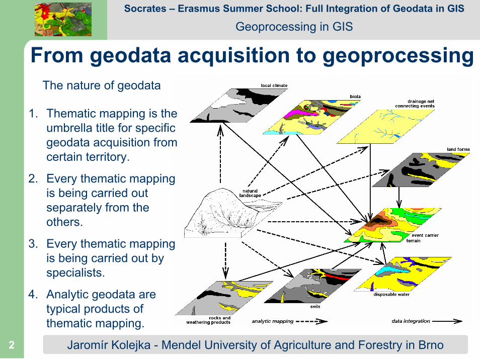
From geodata acquisition to geoprocessingThe nature of geodata
1. The geodata source isthe landscape.
2. Visual and otherlandscape features are transformed intogeodata.
3. The geodata acquisitionis represented by mapping procedures.
4. Mapping procedures are realized by mappingtechniques andtechnologies.
Jaromír Kolejka - Mendel University of Agriculture and Forestry in Brno2
Socrates – Erasmus Summer School: Full Integration of Geodata in GIS
Geoprocessing in GIS
From geodata acquisition to geoprocessing
1. Thematic mapping is theumbrella title for specificgeodata acquisition fromcertain territory.
2. Every thematic mappingis being carried outseparately from theothers.
3. Every thematic mappingis being carried out by specialists.
4. Analytic geodata are typical products ofthematic mapping.
The nature of geodata

Jaromír Kolejka - Mendel University of Agriculture and Forestry in Brno3
Socrates – Erasmus Summer School: Full Integration of Geodata in GIS
Geoprocessing in GIS
From geodata acquisition to geoprocessingThematic mapping technologies: 1) field mapping – primary geodata, 2)
laboratory archieved geodata processing – secondary geodata, 3) remotelysensed geodata – primary geodata, 4) overlay, internet etc. derived data –
tertiary geodata

Jaromír Kolejka - Mendel University of Agriculture and Forestry in Brno4
Socrates – Erasmus Summer School: Full Integration of Geodata in GIS
Geoprocessing in GIS
From geodata acquisition to geoprocessingAdvantages and disadvantages of acquired geodata from the viewpoint of its
application in GIS:
1) field mapping – primary geodata, self responsibility for data quality, wide rangeof knowledge necessary, long time of field work, traditional and present technology suitable (GPS, PDA, iPEG etc.),...
2) laboratory archieved geodata processing – secondary geodata, varyingreliability, different geometric and quality features, preprocessing necessary,...
3) remotely sensed geodata – primary geodata, introductory investment, complexprocessing, expensive technology, coverage, synchronous, homogenous quality,...
4) overlay etc. derived data – tertiary geodata, different scales, formats, geometry, sources, accessibility, expenses, varying quality and reliability, complex collectionand processing,...

Jaromír Kolejka - Mendel University of Agriculture and Forestry in Brno5
Socrates – Erasmus Summer School: Full Integration of Geodata in GIS
Geoprocessing in GIS
Thematic (analytic) Geodata IntegrationRules:
1. Keep relationships natural for factors described by geodata set.
2. Keep resolution representing the working scale(resolution).
3. Apply landscape ecological (or physical-geographical) knowledge.
4. Testify factor combinations derived by GIS procedures.
5. Consequent two-by-two layers integration prefered to total all-layer integration.
Jaromír Kolejka - Mendel University of Agriculture and Forestry in Brno6
Socrates – Erasmus Summer School: Full Integration of Geodata in GIS
Geoprocessing in GIS
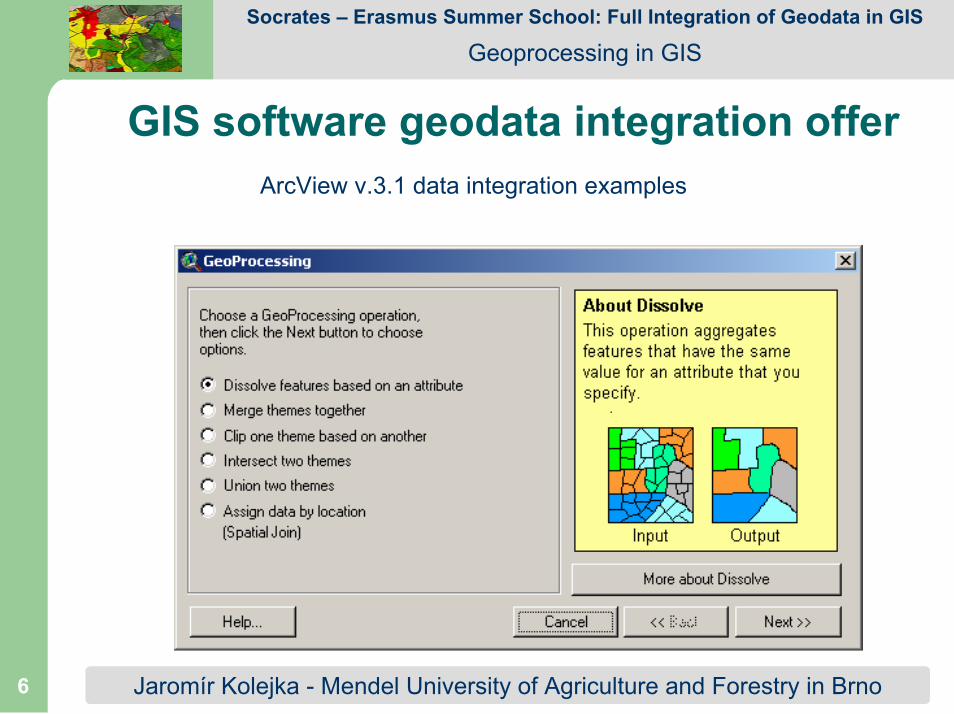
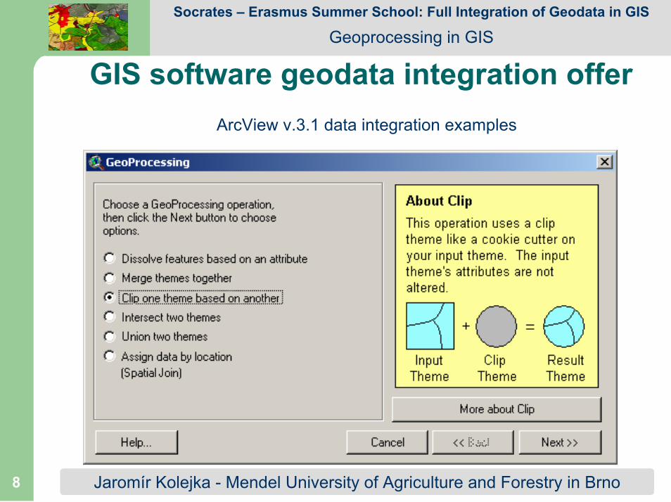
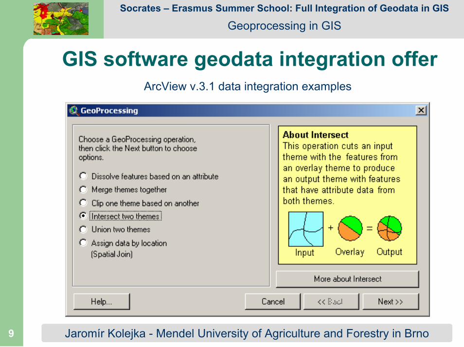
GIS software geodata integration offerArcView v.3.1 data integration examples

Jaromír Kolejka - Mendel University of Agriculture and Forestry in Brno7
Socrates – Erasmus Summer School: Full Integration of Geodata in GIS
Geoprocessing in GIS
GIS software geodata integration offerArcView v.3.1 data integration examples
Jaromír Kolejka - Mendel University of Agriculture and Forestry in Brno8
Socrates – Erasmus Summer School: Full Integration of Geodata in GIS
Geoprocessing in GIS
GIS software geodata integration offerArcView v.3.1 data integration examples
Jaromír Kolejka - Mendel University of Agriculture and Forestry in Brno9
Socrates – Erasmus Summer School: Full Integration of Geodata in GIS
Geoprocessing in GIS
GIS software geodata integration offerArcView v.3.1 data integration examples

Jaromír Kolejka - Mendel University of Agriculture and Forestry in Brno10
Socrates – Erasmus Summer School: Full Integration of Geodata in GIS
Geoprocessing in GIS
GIS software geodata integration offerArcView v.3.1 data integration examples

Jaromír Kolejka - Mendel University of Agriculture and Forestry in Brno11
Socrates – Erasmus Summer School: Full Integration of Geodata in GIS
Geoprocessing in GIS
GIS software geodata integration offerArcView v.3.1 data integration examples

Jaromír Kolejka - Mendel University of Agriculture and Forestry in Brno12
Socrates – Erasmus Summer School: Full Integration of Geodata in GIS
Geoprocessing in GIS
Thematic (analytic) Geodata Integration
Intersection of overlaid geodata sets
Traditionalapproach

Jaromír Kolejka - Mendel University of Agriculture and Forestry in Brno13
Socrates – Erasmus Summer School: Full Integration of Geodata in GIS
Geoprocessing in GIS
Thematic (analytic) Geodata Integration
Examples of typicalgeodata sets
All these data setsrepresent
products ofmutually
independent thematic mapping.
All these data sets are integrated from followingviewpoints: format, scale, resolution, coordinate system, map projection

Jaromír Kolejka - Mendel University of Agriculture and Forestry in Brno14
Socrates – Erasmus Summer School: Full Integration of Geodata in GIS
Geoprocessing in GIS
Thematic (analytic) Geodata Integration
Example of overlay of threedata layers with consequent
intersection.

Jaromír Kolejka - Mendel University of Agriculture and Forestry in Brno15
Socrates – Erasmus Summer School: Full Integration of Geodata in GIS
Geoprocessing in GIS
Thematic (analytic) Geodata IntegrationExample of three-data-layer intersection attribute table
Task: Testifythe correctness
of derivedfeature
combinations in the polygon description.

Jaromír Kolejka - Mendel University of Agriculture and Forestry in Brno16
Socrates – Erasmus Summer School: Full Integration of Geodata in GIS
Geoprocessing in GIS
Thematic (analytic) Geodata Integration
Controlled two-by-two integrationusing geodata intersection.
1. Reference layer selected.
2. Synergetic layer ovelaid andcleaned.
3. (In)dependent layer overlaidand cleaned.
Landscape ecological approach

Jaromír Kolejka - Mendel University of Agriculture and Forestry in Brno17
Socrates – Erasmus Summer School: Full Integration of Geodata in GIS
Geoprocessing in GIS
Thematic (analytic) Geodata Integration
Terrain is the obligatoryreference layer.
Geology is the best thematicreference layer because of its
conservatism.
Geology polygon outlines have to befirst carefully adopted to terrain
represented by contourlines or DTM.

Jaromír Kolejka - Mendel University of Agriculture and Forestry in Brno18
Socrates – Erasmus Summer School: Full Integration of Geodata in GIS
Geoprocessing in GIS
Thematic (analytic) Geodata Integration
overlay + snapping
Cleaned geology according to terrain as thefirst thematic
reference layer.
Integration guide: real relationshipsbetween geology and soils in landscape.

Jaromír Kolejka - Mendel University of Agriculture and Forestry in Brno19
Socrates – Erasmus Summer School: Full Integration of Geodata in GIS
Geoprocessing in GIS
Thematic (analytic) Geodata IntegrationOverlaid polygon outlines
snapping to avoid number ofremnant polygons. Overlaid
layer polygon outlines have to be snapped to approximately
paralel reference layer polygon outlines.
After the snapping the overlaidlayer to the reference layer, the
intersection of layer can becarried out.

Jaromír Kolejka - Mendel University of Agriculture and Forestry in Brno20
Socrates – Erasmus Summer School: Full Integration of Geodata in GIS
Geoprocessing in GIS
Thematic (analytic) Geodata IntegrationIntegrated geology and soil layers Another analytic layer to be intersected
Addiotional overlaid layer first to be snapped

Jaromír Kolejka - Mendel University of Agriculture and Forestry in Brno21
Socrates – Erasmus Summer School: Full Integration of Geodata in GIS
Geoprocessing in GIS
Thematic (analytic) Geodata IntegrationGeoprocessing completed: overlaid,
snapped and intersected data layers are represented in the attribute table by real
feature combinations only.
Efficient application ofGIS technology and
geographical knowledgefor the compilation ofbetter data sets for
various utilising.