geomorphic and tectonic implications of the post...
TRANSCRIPT
Geological Society of America Memoir 144
© 1975
Geomorphic and Tectonic Implications of the
Post-Laramide, Late Eocene Erosion Surface in the
Southern Rocky Mountains
RUDyC.EpIS
Colorado School of Mines Golden, Colorado 80401
AND
CHARLES E. CHAPIN
New Mexico Bureau of Mines Socorro, New Mexico 87801
ABSTRACT
A late Eocene erosion sudace of low relief, which extended throughout south-central Colorado, provides a post-Laramide, pre-Oligocene, regional structural datum. The age and geomorphic character of the sudace are documented for an area of more than 10,400 km2 in the southern Front Range, Rampart Range, South Park, Thirtynine Mile volcanic field, southern Mosquito Range, upper Arkansas River valley, southern Sawatch Range, and adjacent Great Plains to the east. The sudace truncated middle Eocene and older rocks, which were deformed during the Laramide orogeny, and deeply beveled crystalline Precambrian rocks across wide areas. Size, shape, and distribution of the overlying Wall Mountain Tuff and associated gravel units show that the sudace sloped gently southward and eastward and merged with the western Great Plains.
Correlation of deposits on the sudace indicates that it was uplifted 1,500 to 3,000 m and disrupted by block faulting of basin-and-range style in Miocene and later time. Many erosion sudaces now at various levels in the mountainous terrain of the area are faulted segments of this late Eocene sudace.
45
46 EPIS AND CHAPIN
It is suggested that erosion surfaces of similar geomorphic character and age developed over a much larger region of the Southern Rocky Mountains province and of the adjoining Basin and Range province to the south and southwest.
INTRODUCTION
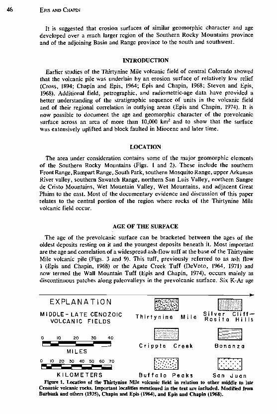
Earlier studies of the Thirtynine Mile volcanic field of central Colorado showed that the volcanic pile was underlain by an erosion surface of relatively low relief (Cross, 1894; Chapin and Epis, 1%4; Epis and Chapin, 1968; Steven and Epis, 1%8). Additional field, petrographic, and radiometric-age data have provided a better understanding of the stratigraphic sequence of units in the volcanic field and of their regional correlation in outlying areas (Epis and Chapin, 1974). It is now possible to document the age and geomorphic character of the pre volcanic surface across an area of more than 10,000 km2 and to show that the surface was extensively uplifted and block faulted in Miocene and later time.
LOCATION
The area under consideration contains some of the major geomorphic elements of the Southern Rocky Mountains (Figs. 1 and 2). These include the southern Front Range, Rampart Range, South Park, southern Mosquito Range, upper Arkansas River valley, southern Sawatch Range, northern San Luis Valley, northern Sangre de Cristo Mountains, Wet Mountain Valley, Wet Mountains, and adjacent Great Plains to the east. Most of the documentary evidence and discussion of this paper relates to the central portion of the region where rocks of the Thirtynine Mile volcanic field occur.
AGE OF THE SURFACE
The age of the prevolcanic surface can be bracketed between the ages of the oldest deposits resting on it and the youngest deposits beneath it. Most important are the age and correlation of a widespread ash-flow tuff at the base of the Thirtynine Mile volcanic pile (Figs. 3 and 9). This tuff, previously referred to as ash flow 1 (Epis and Chapin, 1968) or the Agate Creek Tuff (DeVoto, 1964, 1971) and now termed the Wall Mountain Tuff (Epis and Chapin, 1974), occurs mainly as discontinuous patches along paleovalleys in the prevolcanic surface. Six K-Ar age
EXPLANATION
MIDDLE - LATE CENOZOIC VOLCAN IC FI ELDS
o 10 20 30 40 ,...... i MILES
o 10 20 30 40 50 60 70 ra.
Thirtynine Mile
-Cripple Creek Bonanza
D···· ........... .. ........ ... .. ... ... ... ...
K I L 0 MET ER S 8 u f f a loP e a k s San J u a n Figure 1. Location of the Tbirtynine Mile volcanic field in relation to other middle to late
Cenozoic volcanic rocks. Important localities mentioned in the text are included. Modified from Burbank and others (1935), Chapin and Epis (1%4), and Epis and Chapin (1968).
\ \
\ \ J J (
I .I , )
)
( ( ( ( ( ~
S
° (j) ) ( j
) ( ../
./ ) ,
) ) ) ) )
? .... " (j) t.. v ""'""
o c. -I
°
Z )
Mount Aetno
Po ••
. . ............
) ) )
)BUlno ) VI,ta , 'I
) )
"""
j .I
) '\
) }
)
, 'I )
" < )
:.:.:.:.:.:.: ....... :.:.) . : . :. : . : . : ,\(, .. :~ . : . : . : . ) •••••••••••• '\ ~J .......................... +~~.SOIlUOCh.
:.:.:.:.: .:.:.:.: . ) •••• , •• ''y
38" ••••••••••••••• :I
.-:<-:<-:< .) ••.. ...•••• •• J ............ ) -:':-:-:.:- j ...• ' J .;<-:.::, :-:<.:-> .; <.;.;) ........
'-~
\ C.
(j)
< 1> r r fT1
-<
tE l .... . \.
'.: d!I ( ~ ' 2,···· C ......
': Upland(
". '-tW '. ,0 \
~ -<l ~ ~ilk.raon Pa ..
_~ 1- \.
.' G
'\ ' '"' ,
)
Elevenmlle Conyon Rei .
\.
'"' >" ) ) 'I
..... '" '\ '\ '\ '\
'I )
DENVER BASIN , ....
'I I
?JI v ) ~,
COlt11 Rock
-0\
v' ?J'I -I)
'" " ?J 'I 'Z.)
., . - ~ f&~
~IQnOI Butte
Ul?
Gl ) GREAT ~ lpLAINS , ) " )
Woodland Park \ U. S . Air ForCI • It( ,f,(on'I71ACOdlmy
PI ku Plak
.... \1/ ::;./\E-
Min.
,-. Conon City / "\ emboyment
( , \ , l~ \ (~ ) ( "A )-., ( "'\
l ~ '\-" 0c:::. '\
-t-"A '\ Y' ) % )
'////'/_~"" ) ) )
'\ G''''hO'~~t~~ '\
\ \" \.
) )
B", ~
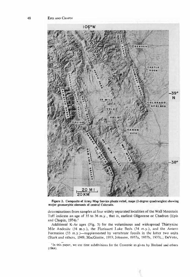
48 EPIS AND CHAPIN
Figure 2. Composite of Army Map Service plastic relief, maps (2-degree quadrangles) showing major geomorphic elements of central Colorado.
determinations from samples at four widely separated localities of the Wall Mountain Tuff indicate an age of 35 to 36 m.y., that is, earliest Oligocene or Chadron (Epis and Chapin, 1974).1
Additional K-Ar ages (Fig . 3) for the voluminous and widespread Thirtynine Mile Andesite (34 m.y.), the Florissant Lake Beds (34 m.y .), and the Antero Formation (33 m.y .)- supplemented by vertebrate fossils in the latter two units (Stark and others , 1949; MacGinitie, 1953; Johnson, 1937a, 1937b, 1937c, ; DeVoto,
I In this paper, we use time subdivisions for the Cenozoic as given by Harland and others (1964) .

AGE
,", OlZ
Generally west or south
POST-LARAMIDE, LATE EOCENE EROSION SURFACE 49
Guffey Center Generally east or north
CONTINUED BLOCK FAULTING
ffi~~---------------------, g 8 Post volcanic sedimentary ~ ~ rocks I Postvolcanic sedimentary
rocks
!:l ~ ~--~------~---------, o Andesite of Waugh Mountain-;: 19 may.
"' Z
"' u
§ ..., a
Conglomerate of Fear Creek-27 m.y.
Gribbles Park Tuff-29 m.y. Thorn Ranch Tuff East Gulch Tuff
Badger Antero Balfour Creek Formation
Formation of Tuff- of Johnson
Johnson 31.9 (1937) m.y. (1937)-
" " ., "' ...
BLOCK FAULT ING
Upper member-34 m. y ..
-ii ~ ~-----------------;
"'''' ., '" .~ td!
Lower member
33 m.y. ~::::::~------~==::::::j~ " t- 8 ~ t-Tu--f -f -o-f-S-t-i-r-ru-p--Ra-n-C-h"".)
Lower member
Tallahassee Creek Conglomerate
Wall Mountain Tuff-35-36 m.y.
I Phonoli te of Cripple Creek-28 m.y.
Florissant Lake Beds-34 m.y.
Lower member
~ Echo Park All uvi urn. ffi r---------------------------------------------------------------------------, u 2 PREVOLCANIC EROSION SURFACE
'--LARAMIDE FOLDING, THRUSTING, A.~D EROSION
Figure 3. Generalized composite stratigraphy of the Thirtynine Mile volcanic field.
1971)--confirm the early Oligocene age of the Wall Mountain Tuff. It is clear that the prevoIcanic surface can be no younger than very earliest Oligocene.
At various localities within the area shown on Figures ] and 2, the prevoIcanic erosion surface truncates Laramide uplifts, their bounding structural features, cores of Precambrian rocks, and upwarped flanking sedimentary units of pre-Oligocene age. The youngest sedimentary rocks involved in Laramide deformation and truncation by the surface establish a lower limit on the age of the surface. In eastern South Park, continental sedimentary and interbedded andesitic rocks, which are termed the Denver Formation (Johnson, 1937b; Stark and others, 1949) or South Park Formation (Sawatzky, 1967; DeVoto, 1971), have been folded and overthrust by Precambrian to Mesozoic rocks of the Front Range along the Elkhorn thrust. Stark and others (1949) and Sawatzky (1%4, 1 %7) showed thatthe prevoIcanic surface ("Elkhorn Upland") truncates the Elkhorn thrust and the folded strata of the South Park Formation. An andesite flow at the base of the South Park Formation yielded a K-Ar age of 56.8 ± 2.6 m.y. (Sawatzky, 1%7) which, together with paleontologic data of Johnson (1937a, 1937b) and Brown (1%2), indicates that the South Park Formation was deposited in late Paleocene and probably early Eocene time. Scattered outcrops of the Wall Mountain Tuff rest on the beveled upper plate of the Elkhorn thrust; therefore, in this area, the age of the pre volcanic surface is bracketed between late Paleocene (or early Eocene) and earliest Oligocene time.
Similar relations of the prevokanic surface to Laramide structural features and early Tertiary sedimentary rocks can be documented elsewhere in central Colorado. In the Castle Rock area, outcrops of tuff that was dated at 34.8 ± 1.1 m.y. (Izett
50 EPlS AND CHAPIN
and others, 1969; Welsh, 1969) have been correlated with the Wall Mountain Tuff on the basis of similarities in age, stratigraphic position, modal mineral content, 2Vof sanidine, and chemical composition (Epis and Chapin, 1974). The age of the tuff is corroborated by an early Oligocene vertebrate fauna in the overlying Castle Rock Conglomerate (Richardson, 1915; Izett and others, 1969). The tuff rests on an erosion surface carved on the Dawson Formation of Late Cretaceous and Paleocene age (Brown, 1943). The Dawson is involved in folding and thrusting along the east side of the Front Range in a manner analogous to that of the South Park Formation along the west side. Accordingly, the age of the pre volcanic surface in the Denver basin is bracketed between Paleocene and earliest Oligocene. Similar relations in the Canon City embayment exist between the Poison Canyon Formation of Late Cretaceous and Paleocene age and outliers of Oligocene volcanic rocks of the Thirtynine Mile volcanic field (G. R. Scott, 1973, oral commun.).
Beneath the main body of the Thirtynine Mile volcanic field, the prevolcanic surface was developed largely on beveled Precambrian rocks. Within this area, the youngest rocks beneath the surface are reddish, arkosic, conglomeratic mudstone, conglomerate, and minor sandstone units named the Echo Park Alluvium (Epis and Chapin, 1974). These deposits fill a narrow graben that trends north-northwest from the Arkansas River Canyon to the vicinity of Guffey; minor volumes of similar material are found in several paleovalleys on the prevolcanic surface, as for example near Florissant (Niesen, 1969) and at High Park (Tobey, 1969). In such cases, they are directly overlain by the Wall Mountain Tuff. No fossils have been found in the Echo Park Alluvium, but it is similar in lithologic content, color, and stratigraphic position to the Huerfano Formation and Farisita Conglomerate in the Huerfano Park area. The Huerfano and Farisita overlie the Poison Canyon Formation of Late Cretaceous-Paleocene age and interfinger with the Cuchara Formation of probable Eocene age (Johnson and Wood, 1956; Johnson, 1959; Scott and Taylor, 1975). Development of the surface is thus bracketed here between deposition of sediment of probable Eocene age and eruption of volcanic rocks of earliest Oligocene age, .
Carving of the erosion surface began with the start of the Laramide orogeny at the close of Campanian time (Tweto, 1975). Thousands of meters of Mesozoic and Paleozoic sedimentary rocks and an unknown thickness of Precambrian rocks were eroded from uplifts during Late Cretaceous, Paleocene, and Eocene time. Erosion apparently kept pace with uplift so that mountains never stood very high above adjacent aggrading basins. When active deformation ceased in late Eocene time, weathering that occurred under a warm, temperate to subtropical climate (MacGinitie, 1953; Leopold and MacGinitie, 1972) and lateral planation by streams produced a surface of very low relief that embraced both beveled uplifts and aggraded basins. Accordingly, the surface as preserved represents a period of post-Laramide tectonic and magmatic quiescence during late Eocene and possibly very earliest Oligocene time. For the sake of convenience, we refer to the surface throughout this paper as the late Eocene surface.
EXTENT OF THE SURFACE
The extent of the late Eocene erosion surface can be documented most clearly in central Colorado by the distribution of the Wall Mountain Tuff and by correlation of exhumed remnants of the surface often strikingly evident in panoramic views of the region (see Figs. 8, 9, 15, and 16). Reconstruction of the surface has been facilitated by an optimum level of erosion that is deep enough to exhume large
POST-LARAMIDE, LATE EOCENE EROSION SURFACE
portions of the surface from beneath its middle Tertiary cover but not so deep as to remove all remnants of the overlying Wall Mountain Tuff or to obscure the nature of the surface.
Because of the importance of the Wall Mountain Tuff to this reconstruction, a brief summary of its lithologic characteristics is given below:
The Wall Mountain Tuff is a multiple-flow, simple cooling unit of moderate to dense welding with conspicuous eutaxitic foliation. It tends to form c1ifflike outcrops of reddish-brown to buff lithoidal tuff, sometimes with a prominent black vitrophyre zone near the base. Primary and secondary laminar flow structures are common (Lowell and Chapin, 1972). Chemically, the tuff is a potassic calc-alkalic rhyolite but mineralogically, it is a trachyte. Clear, "glassy" sanidine and fresh to intensely argillized andesine are the principal phenocrystic minerals. Biotite and lesser opaque oxides compose 6 to 9 percent of the tuff; traces of pyroxene are frequently present. Quartz is absent as a phenocryst. The sanidine/plagioclase ratio varies from 0.9 to 4.4 and averages about 2.0. The 2 V values for sanidine (or anorthoclase) range from 22° to more than 50" with median values for the four ash-flow members of 30S, 34°, 380, and 4r (Chapin, 1%5; Lowell, 1%9). Tan to pink felsite lithic fragments are moderately abundant in the Browns Canyon area but sparse to absent elsewhere. The tuff has normal magnetic polarity (Graebner, 1%7; Graebner and Epis, 1%8) and generally occurs in isolated outcrops less than 30 m thick. In major paleoval\eys, however, thicknesses greater than 150 m are preserved.
The Wall Mountain Tuff has been correlated across an area of about 10,400 km 2• Most of the outcrops are in paleovalleys in the late Eocene surface. Erosion has stripped most of the tuff from interfluves, but in many paleovalleys, it is protected by overlying sedimentary and (or) volcanic deposits. The tuff most commonly rests on Precambrian rocks, but locally it rests on other pre-Oligocene rocks beveled by the late Eocene surface or on Eocene sedimentary deposits in basins and valleys that were aggrading during carving of the surface (Fig. 4). The source of the Wall Mountain Tuff is not known with certainty; it may have been erupted from vents related to the Mount Princeton batholith in the Sawatch Range. A deeply eroded cauldron complex in the Mount Aetna area north of Monarch Pass (Dings and Robinson, 1957; Lipman and others, 1%9; P. J. Toulmin, 1973, oral commun.) is a likely source. From this general area, the ash flows moved eastward down major paleovalleys, such as those at Trout Creek and between Browns Canyon and Waugh Mountain (Fig. 1), and spread widely over the late Eocene surface that sloped gently to the east and southeast.
The late Eocene surface can be traced discontinuously through much of Colorado and New Mexico by applying similar criteria, that is, by examining the distribution of early Oligocene deposits on a surface 'Of low relief which truncates Laramide structures. The original extent of the late Eocene surface is yet to be worked out. However, termination of Laramide deformation in late Eocene time (Tweto, 1975; Coney, 1972) and the existence of a late Eocene hiatus in magmatism over most of the Southern Rocky Mountains and Basin and Range provinces (Damon and Mauger, 1%6; Livingston and others, 1968; Cross, 1973) lead us to suggest that the surface documented in this paper may be part of a very widespread surface of regional importance.
T~ '"~~=T - -- -
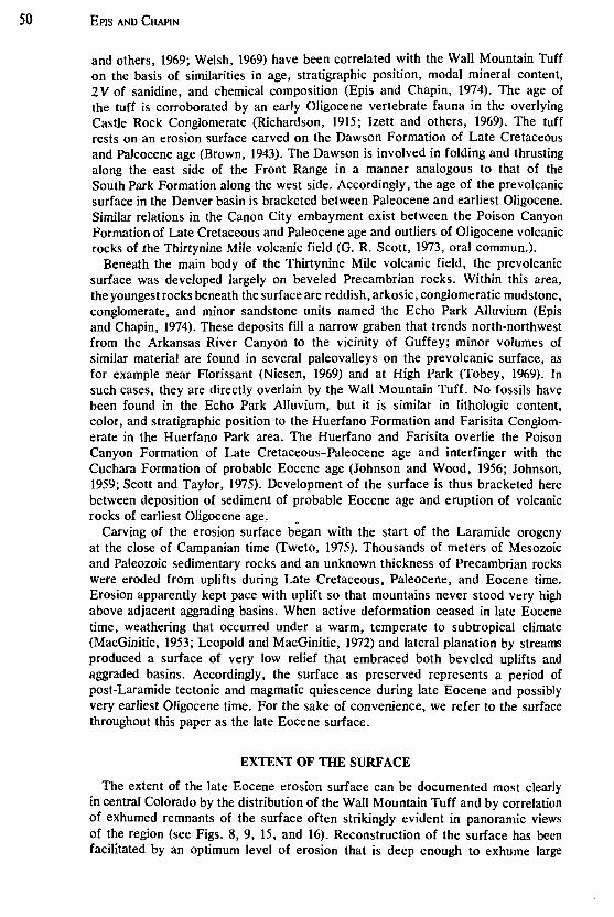
Figure 4. Diagram illustrating typical relations of topography of the late Eocene surface (cut on middle Eocene or older rocks) and overlying Echo Park Alluvium (circles and dots) and Wall Mountain Tuff (wavy lines). Vertical scale is in feet.
51
utUVERSIT'{ Of AH\\P UBRAR'i

52 EPIS AND CHAPIN
GEOMORPHIC CHARACTER OF THE SURFACE
Relief
The late Eocene erosion surface was characterized by relatively low relief and was channeled by shallow, broad stream valleys (Fig. 4). The ash flows that deposited the Wall Mountain Tuff followed these valleys where convenient but had no difficulty in jumping interfluves between them. Except in major valleys near the source of the eruptions, outcrops of the Wall Mountain Tuff are generally less than 30 m thick. Had there been considerably more relief on the surface, the ash flows would have puddled in the valleys and filled them before overriding the interfIuves. Instead, the drainage was quickly re-established in the shallow paleovalleys, and the Wall Mountain Tuff was extensively dissected so that in many areas only thin, scattered remnants remained. These remnants were buried by the Tallahassee Creek Conglomerate, mudflows of the Thirtynine Mile Andesite, and shallow lacustrine deposits, such as those in the Antero basin, at Balfour, and in the Florissant basin where lakes formed along the north side of the Thirtynine Mile volcanic field as a result of volcanic damming of drainages.
In his paleontologic studies of the Florissant Lake Beds, MacGinitie (1953, p. 11) stated the following about the late Eocene surface:
This time of erosion probably occupied the greater part of the later Eocene, and, to judge from the low relief of the surface developed on the Pikes Peak granite, and from the comparatively fine sediments associated with the base of the Florissant series, the surface had reached an early old-age stage of the erosion cycle.
MacGinitie further concluded (p. 77) that:
The Oligocene forest occupied streamside and lakeside habitats in a piedmont of low relief and moderate elevation which bordered the Rocky Mountain uplift on the east. The drainage was disorganized and partly ponded by successive volcanic outbursts which covered the area with dust, pumice, and mudflows. The fossil fauna and flora were deposited in the resulting shallow and ephermerallakes.
MacGinitie's interpretations of the nature of the late Eocene surface in the Florissant area can be applied to the surface in general. Stark and others (1949, p. 138) drew similar conclusions regarding late Eocene topography in eastern South Park: ". . . by the end of the Eocene the region had been reduced to a gently rolling upland, above which rose a few well-rounded monadnocks."
Additional information about the relief of the late Eocene surface can be obtained where the surface is now being exhumed from beneath the Thirtynine Mile volcanic field (Fig. 5). As the edges of the volcanic pile retreat, the relatively flat, gently rolling terrain uncovered usually has shallow paleo valleys and scattered outcrops of the Wall Mountain Tuff. This type of terrain is especially conspicuous in the eastern portion of the Thirtynine Mile volcanic field where the Elkhorn Upland in eastern South Park can be traced eastward and southeastward as a gently rolling terrain underlain by Precambrian rocks on which rest isolated outcrops of the Wall Mountain Tuff (Fig. 6). Similar topographic and geologic relations are present south of West Fourmile Creek between Currant Creek on the west and Oil Creek on the east (Fig. 7). Here, shallow paleovalleys containing remnants of the Wall Mountain Tuff, overlain by boulder alluvium, project from beneath the Thirtynine Mile Andesite. The surface can be traced southward across the highly dissected country near the Arkansas River Canyon to the De Weese Plateau in the northwestern foothills of the Wet Mountains (Fig. 8). Here, again, gently rolling terrain with

POST-LARAMIDE, LATE EOCENE EROSION SURFACE
concordant summits has been developed on Precambrian rocks on which rest scattered outcrops of Oligocene volcanic rocks.
Whereas the late Eocene surface was generally characterized by relatively flat , gently rolling terrain as described above, appreciably greater relief was present locally. Major valleys heading in the Laramide Sawatch uplift were filled with as much as 300 m of Oligocene sedimentary and volcanic rocks (Lowell, 1969, 1971; Chapin and others , 1970) . Elsewhere in the Thirtynine Mile volcanic field,
53
Figure 5. Oblique aerial view northward into the head of Echo Park from above the canyon of the Arkansas River (lower right) . The smooth prevolcanic surface is shown by the dashed line. A pre volcanic paleovalley in Precambrian rocks, filled with Echo Park Alluvium, is extensively exhumed (right of center). The Wall Mountain Tuff and the lower member of the Thirtynine Mile Andesite rest on Precambrian rocks and Echo Park Alluvium. Cliffs of the Gribbles Park Tuff and overlying andesite of Waugh Mountain form the rim of Echo Park. Eastern Waugh Mountain (WM), Dicks Peak (DP), Thirtynine Mile Mountain (TM), and Cover Mountain (CM) are volcanic constructional features of the Thirtynine Mile volcanic field. Caprock Ridge (CR) is a thin sheet that consists of Wall Mountain Tuff, Tallahassee Creek Conglomerate, and Thirtynine Mile Andesite resting on the prevolcanic surface. Length of dashed line represents about 11 km.
Figure 6. Oblique aerial view from above High Park northeastward across the extensively exhumed late Eocene surface (middle foreground). Note the low, roIling relief of the surface carved into Precambrian rocks. Miocene·Pliocene gravel units rest on the surface in the vicinity of Divide (d). The Wall Mountain Tuff and Florissant Lake Beds are preserved in a shallow paleovalley in the Florissant basin (f). Southward, at the junction of Fourmile Creek (fm) and Oil Creek (oc) the Tallahassee Creek Conglomerate and lower member of the Thirtynine Mile Andesite rest on the surface in related paleovalleys. Along the east side of Oil Creek and the Florissant basin, the surface has been upfauJted a few hundred meters to the general level of Divide. The smooth late Eocene surface is clearly visible on the skyline along the crest of the Rampart Range where it is upfauJted about 300 m above the general level of Divide. The monadnock, called Devils Head, stands above the surface at the left end of the skyline. Isolated outcrops of gravel units correlative with those at Divide and small outcrops of the Wall Mountain Tuff occur on the surface atop the Rampart Range.
54 EPIS AND CHAPIN
isolated ridges of Precambrian rock stood as high as 240 m above the general level of the surface. In the Tallahassee Creek area, a meandering main-stem drainage carved a narrow, steep-walled valley through such a ridge (Chapin, 1965).
A few larger areas of positive relief existed- because even today they stand as monadnocks above the general level of the surface exhumed in their immediate surroundings. Examples are Devils Head in the northern Rampart Range (Figs . 6 and 15) and the summit portion of Pikes Peak above about 3,800 m (Fig. 20) . Many of the present high mountains above the level of the surface, such as Thirtynine Mile and Waugh Mountains and the Buffalo Peaks, are modified volcanic landforms constructed on the surface. Essentially all other mountainous areas that now rise above adjacent segments of the surface are considered to have resulted from late Cenozoic block faulting and ensuing erosion.
In a few cases, the late Eocene erosion surface coincides with stripped surfaces that are pre-Paleozoic and (or) early Mesozoic unconformities . Examples of such areas are found in the vicinity of High Park and the Bare Hills, in the southern portion of the Front Range south of the Cripple Creek volcanic pile, and along the crest of the Wet Mountains south of Greenhorn Mountain . These areas are exceptional in that fortuitous circumstances allowed pre-late Eocene unconformities to be elevated by Laramide orogenic movements to levels that eventually were to coincide with local profiles of the late Eocene surface. Elsewhere, it is clear that thousands of meters of Paleozoic to middle Eocene sedimentary rocks were removed and Precambrian crystalline rocks were deeply eroded in the cores of large truncated Laramide structures.
Drainage Patterns and Regional Slope
The regional eastward and southeastward slope on the late Eocene surface was such that it merged with the western Great Plains . This conclusion is based on mapping and reconstruction of (1) paleovalleys, (2) distribution of early Oligocene volcanic and sedimentary rocks, (3) flow directions deduced from laminar flow
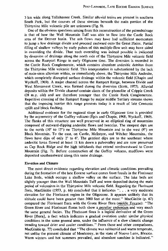
Figure 7. Oblique aerial view across the northeast rim of the valley of Currant Creek (CC). The prevolcanic erosion surface is carved into Precambrian rocks, extends beneath a thin sheet of volcanic rocks at the southeastern end of Caprock Ridge (CR), and emerges in the vicinity of High Park (HP) west of upper Oil Creek. The erosion surface (ES) is upfauIted on the east side of upper Oil Creek and the Florissant basin and extends northward (left) to the vicinity of Divide. (PP) is northern base of Pikes Peak.

POST-LARAMIDE, LATE EOCENE EROSION SURFACE 55
structures and other features of the Wall Mountain Tuff, (4) damming of drainages and formation of lakes along the north and northwest sides of the Thirtynine Mile volcanic pile, (5) asymmetry of the Guffey volcano, and (6) considerations of the regional paleogeography during early and middle Tertiary time.
Numerous paleovalleys, well preserved on exhumed portions of the late Eocene surface, enable reconstruction of major portions of the paleodrainage. Figure 9 shows the locations of these paleovalleys and the drainage patterns interpreted from them. Several paleovalleys are exposed along the east side of the upper Arkansas River valley between Salida and Buena Vista where westward-forking tributaries and relatively deeper canyons indicate that the paleovalley headwaters lay to the west on the Laramide Sawatch uplift (Chapin and others, 1970). The two largest and best preserved of these paleo valleys are located between Browns Canyon and Waugh Mountain (Lowell, 1969, 1971) and along Trout Creek near Buena Vista. The Wall Mountain Tuff, unwelded ash-flow tuffs in the Antero Formation, Badger Creek Tuff, and Gribbles Park Tuff all attain maximum thickness and number of member units in one or the other of the two major paleovalleys. These observations suggest that sources of most of the ash-flow tuff units of the Thirtynine Mile volcanic field lay to the west of the field and that such major valleys were channels through which the ash flows moved before spreading over the relatively gentle terrain of the late Eocene surface to the east and southeast.
Detailed studies of laminar flow structures in the Wall Mountain Tuff along the Gribbles Run paleovalley, 17 km northeast of Salida (Lowell and Chapin, 1972), substantiate an eastward flow direction for the first tuff to be erupted onto the late Eocene surface. The Wall Mountain Tuff traveled at least 240 km from its probable vent area above the Mount Princeton batholith in the Sawatch Range to its distal end in the Castle Rock area on the Great Plains. Abundant light-tan felsite lithic fragments occur in this tuff in the paleovalley at Browns Canyon and indicate nearness to the source of the tuff; the lithic fragments are only occasionally seen in outcrops to the east. Near its distal end in the Castle Rock area, the Wall Mountain Tuff is less welded and has an unusually high ratio of matrix to phenocrysts. Yet another indication of eastward flow is the fact that basal black vitrophyre zones are thickest and most continuous in paleovalleys along the western edge of the Thirtynine Mile volcanic field. Vitrophyre zones are present as far east as Florissant, but east of Agate Creek (Fig. l) in southwestern South Park, such occurrences are small and isolated. The combined effects of higher temperatures of emplacement, greater thicknesses, and higher retention of original volatile constituents allowed more complete compaction and welding along the western edge of the Thirtynine Mile volcanic field. Because movement of most nuees ardentes is influenced by pre-existing topography, eastward transport of the Wall Mountain Tuff is considered a reliable indication of eastward regional slope of the prevolcanic surface.
The late Eocene surface also had a southward component of slope as indicated by the trends of two main-stem drainages in the central and eastern portions of the Thirtynine Mile volcanic field. One of these streams meandered southeastward through the Cottonwood Creek-Tallahassee Creek area (Fig. 1), and the other flowed southward along the present general trend of Oil Creek. Both of these master streams probably headed on higher slopes west and north of South Park and drained into the Canon City embayment. Their courses are partially known from alluvial trains deposited on top of, and in channels which cut through, the Wall Mountain Tuff. These deposits have,been named the Tallahassee Creek Conglomerate (Epis and Chapin, 1974); they are as much as 105 m thick and

Figure 8. View of the late Eocene surface south-southeastward from near the head of Echo Park. The surface in the northern part of the De Weese Plateau is immediately south of the Arkansas River Canyon (central part of the photograph) and is cut across Precambrian rocks. Isolated remnants of the Gribbles Park Tuff rest on the surface. Considerable dissection of the surface has been accomplished
by the Arkansas River and its tributaries. The rather smooth profile on the left skyline is the late Eocene surface where it forms the crest of the northern and central Wet Mountains and is upfauJted along the lise fault more than 460 m above the general level of the De Weese Plateau (Taylor, 1975). The Wet Mountain Valley and the Sangre de Cristo Mountains are visible in the upper right of the photograph.
POST-LARAMIDE, LATE EocENE EROSION SURFACE
3 km wide along Tallahassee Creek. Similar alluvial trains are present in southern South Park, but the courses of these streams beneath the main portion of the Thirtynine Mile volcanic pile are unknown (Fig. 9).
One of the obvious questions arising from this reconstruction of the paleodrainage is that of how the Wall Mountain Tuff was able to flow into the Castle Rock area of the Denver basin. The ash flows may have had sufficient momentum to jump a low drainage divide and proceed eastward onto the Great Plains. Partial filling of shallow valleys by early pulses of this multiple-flow unit may have aided in overriding the divide. That such overriding was indeed possible is indicated by diversion of drainage along the north side of the Thirtynine Mile volcanic field across the Rampart Range in early Oligocene time. The diversion is recorded in the Castle Rock Conglomerate, which contains abundant andesitic detritus from the Thirtynine Mile volcanic field. This interpretation is substantiated by the lack of main-stem alluvium within, or immediately above, the Thirtynine Mile Andesite, which completely disrupted surface drainage within the volcanic field (Chapin and Wyckoff, 1969). A major channel across the Rampart Range, between Divide and West Monument Creek, was formed during the diversion (Scott, 1975). Alluvial deposits within the Divide channel contain clasts of the phonolite of Cripple Creek (28 m.y. old) and are therefore younger than the Castle Rock Conglomerate. Repetitive crossing of the Rampart Range by major middle Tertiary streams shows that the imposing barrier this range presents today is a result of late Cenozoic uplift and block faulting.
Additional evidence for the regional slope in early Oligocene time is provided by the asymmetry of the Guffey volcano (Epis and Chapin, 1968; Wyckoff, 1969). The flanks of this structure are well preserved in an elliptical ring of mountains composed of outward-dipping andesitic flows and breccias. The steepest dips are to the north (10° to 15°) on Thirtynine Mile Mountain and to the west (8°) on Black Mountain. To the east, on Castle, McIntyre, and Witcher Mountains, the flows have dips of only 2° to 6°. The gentlest dips are to the southeast where andesitic lavas flowed at least 11 km down a paleovalley and are now preserved as Cap Rock Ridge and the high tablelands that extend northwestward to Cover Mountain (Fig. 7). Before construction of the Guffey volcano, mudflows were deposited southeastward along this same drainage.
Elevation and Climate
The most direct evidence regarding elevation and climatic conditions prevailing during the formation of the late Eocene surface comes from fossils in the Florissant Lake Beds, which occupy a shallow valley on the surface. The lake beds are slightly younger than the Wall Mountain Tuff and were deposited during the main period of volcanism in the Thirtynine Mile volcanic field. Regarding the Florissant flora, MacGinitie (1953, p. 66) concluded that it indicates" ... a very moderate elevation for the Florissant region in the Oligocene. It appears unlikely that its altitude could have been greater than 3000 feet at the most." MacGinitie (p. 67) compared the Florissant flora with the Green River flora (middle Eoc~): "The Green River and Florissant floras both show a~culiar endemism and very much the same general facies. The Florissant flora is a logical derivative of the Green River [flora], a fact which indicates a gradual evolution under similar physical conditions in the same general area, under the influence of a slow climatic change trending toward drier and cooler conditions." From these and other comparisons, MacGinitie (p. 77) concluded that "The climate was subhumid and warm temperate, not unlike the present climate of Monterrey, in the state of Nuevo Leon, Mexico. Warm winters and hot summers prevailed, and abundant sunshine is indicated."

Figure 9. Composite of Army Map Service plastic relief maps (2.degree quadrangles) showing reconstruction of major paJeodrainages on the late Eocene erosion surface during deposition of the Wall Mountain Tuff and Tallahassee Creek Conglomerate. Known paleovalleys and alluvial trains are shown with solid lines; interpreted linkage of these is shown with dashed lines. Minimum original extent of the Wall Mountain Tuff (- 10,400 km 2
) is outlined by the dotted line. Numbers refer to present elevations (in hundreds of feet) of the base of the Wall Mountain Tuff, which lies on the late Eocene surface. Figures 1, 2, 19, and 21 show related information.
POST-LARAMIDE, LATE EOCENE EROSION SURFACE
He interpreted average annual temperatures as probably never lower than 18°C (65°F), minimum temperatures not less than -7°C (20°F), and annual rainfall not exceeding 640 mm and probably not more than 510 mm (p. 57-58). Leopold and MacGinitie (1972) reaffirmed these conclusions.
Indirect evidence concerning the general elevation and climate at the time the late Eocene surface reached its maximum development can be obtained by tracing regional lithologic and paleontologic trends. Dott and Batten (1971, p. 404-406) summarized these trends as follows:
About the end of Paleocene time, North America's last epeiric sea apparently retreated to the Gulf of Mexico .... During the Eocene Epoch, basin-filling or aggradation continued, but with gradual diminution of coal. Pink, yellow, and red silts and shales are especially characteristic of the Eocene, and typically are eroded into picturesque badlands topography . . . . This widespread sequence represents much of the early basin fill deposited in rivers, lakes, and swamps .... On uplands surrounding the Eocene lakes, a lush forest of redwood and other trees thrived. By ecologic analogy with modern counterparts, the fossil flora points to uniformly mild, humid temperate conditions in marked contrast with the present climate. . . . Basin filling was largely completed during late Eocene and early Oligocene time. Oligocene and Miocene strata overlap beyond older ones to rest unconformably upon eroded pre-Cenozoic rocks. . . . The net result of erosion and filling was to smooth the topography and, as uplift and erosion slackened for perhaps 5 or 10 million years, the landscape became relatively stable.
The Florissant data are consistent with regional environmental trends. The late Eocene surface sloped gently southeastward to the Gulf of Mexico, probably at a rate of 0.4 to 0.6 m/km. The elevation estimated by MacGinitie is a maximum elevation; the actual elevation of central Colorado in the late Eocene was probably somewhat less. It appears certain that formation of the surface was completed after Laramide orogenic activity ceased and that it generally did not consist of geomorphic elements controlled by Laramide structures. It clearly must have obliterated such elements; moreover, the climate, altitude and geomorphic character of the surface differed dramatically from those of today.
UPLIFT AND DISRUPTION OF THE SURFACE BY BLOCK FAULTING
During Miocene and later time, the area was uplifted about 1,500 to 3,000 m. The late Eocene surface, which formed at elevations less than 900 m, now is found at elevations of 2,300 to 3,800 m. Uplift was accompanied by significant block faulting and displacement ofthe surface. Figure 9 shows the present distribution of the WaIl Mountain Tuff at significantly different elevations on the surface. It is clear that the once rather smooth and planar surface was disrupted and differentially raised and lowered in adjacent blocks.
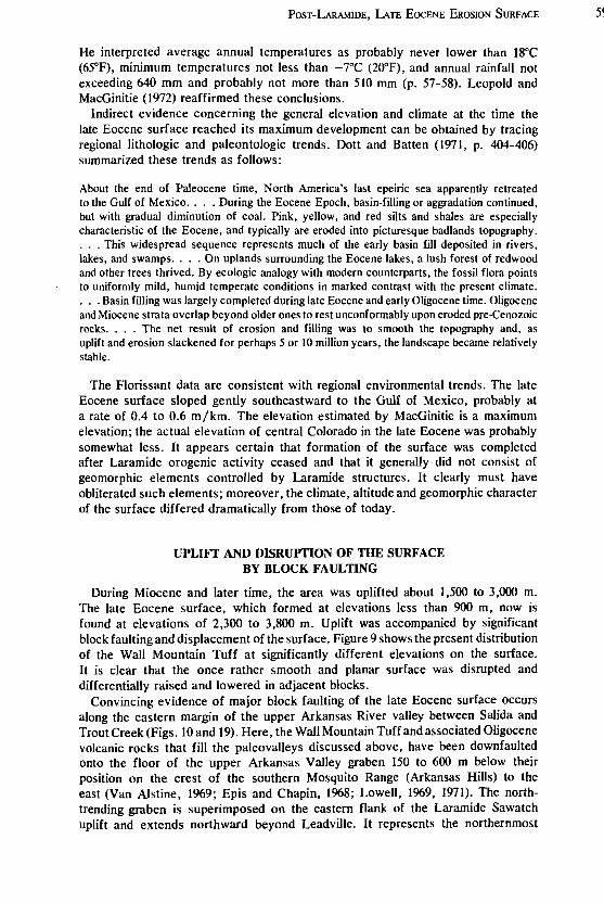
Convincing evidence of major block faulting of the late Eocene surface occurs along the eastern margin of the upper Arkansas River vaIley between Salida and Trout Creek (Figs. 10 and 19). Here, the Wall Mountain Tuff and associated Oligocene volcanic rocks that fill the paleo valleys discussed above, have been downfaulted onto the floor of the upper Arkansas Valley graben 150 to 600 m below their position on the crest of the southern Mosquito Range (Arkansas Hills) to the east (Van Alstine, 1%9; Epis and Chapin, 1%8; Lowell, 1969, 1971). The northtrending graben is superimposed on the eastern flank of the Laramide Sawatch uplift and extends northward beyond Leadville. It represents the northernmost
5S
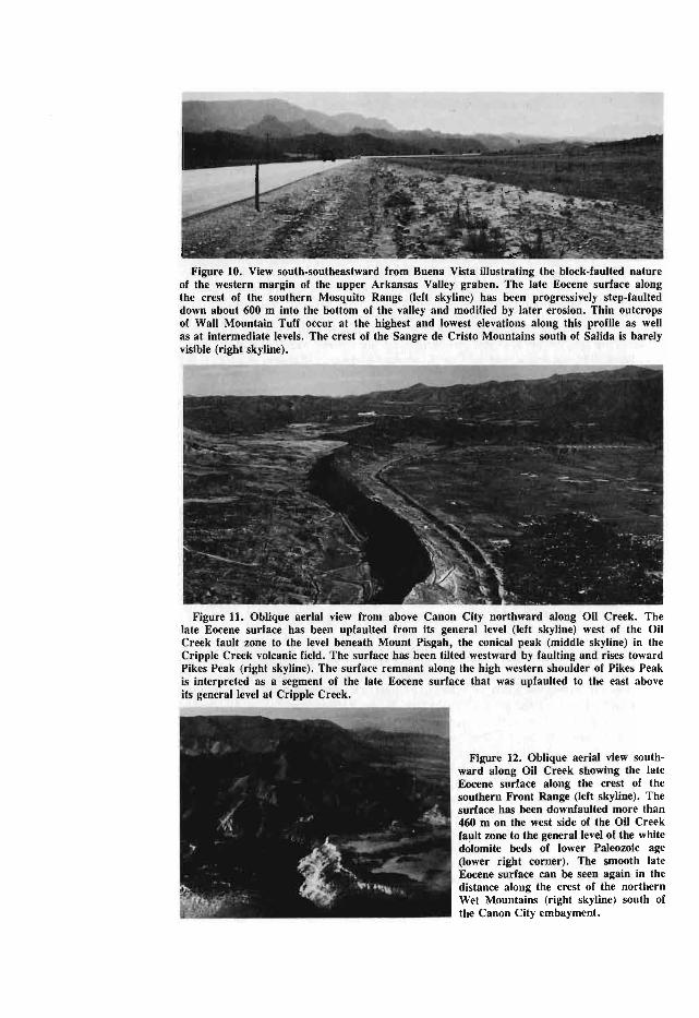
Figure 10. View south-southeastward from Buena Vista illustrating the block-faulted nature of the western margin of the upper Arkansas Valley graben. The late Eocene surface along the crest of the southern Mosquito Range (left skyline) has been progressively step-faulted down about 600 m into the bottom of the valley and modified by later erosion. Thin outcrops of Wall Mountain Tuff occur at the highest and lowest elevations along this profile as well as at intermediate levels. The crest of the Sangre de Cristo Mountains south of Salida is barely visible (right skyline).
Figure 11. Oblique aerial view from above Canon City northward along Oil Creek. The late Eocene surface has been upfaulted from its general level (left skyline) west of the Oil Creek fault zone to the level beneath Mount Pisgah, the conical peak (middle skyline) in the Cripple Creek volcanic field. The surface has been tilted westward by faulting and rises toward Pikes Peak (right skyline). The surface remnant along the high western shoulder of Pikes Peak is interpreted as a segment of the late Eocene surface that was upfaulted to the east above its general level at Cripple Creek.
Figure 12. Oblique aerial view southward along Oil Creek showing the late Eocene surface along the crest of the southern Front Range (left skyline). The surface has been downfaulted more than 460 m on the west side of the Oil Creek fault zone to the general level of the white dolomite beds of lower Paleozoic age (lower right corner). The smooth late Eocene surface can be seen again in the distance along the crest of the northern Wet Mountains (right skyline) south of the Canon City embayment.
POST-LARAMIDE, LATE EOCENE EROSION SURFACE
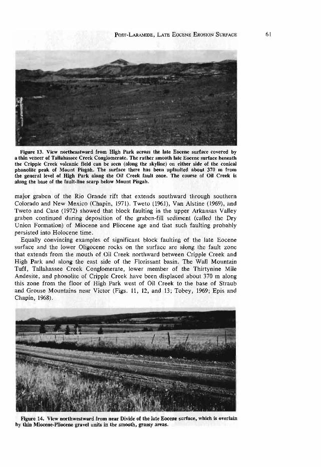
Figure 13. View northeastward from High Park across the late Eocene surface covered by a thin veneer of Tallahassee Creek Conglomerate. The rather smooth late Eocene surface beneath the Cripple Creek volcanic field can be seen (along the skyline) on either side of the conical phonolite peak of Mount Pisgah. The surface there has been upfaulted about 370 m from the general level of High Park along the Oil Creek fault zone. The course of Oil Creek is along the base of the fault-line scarp below Mount Pisgah.
major graben of the Rio Grande rift that extends southward through southern Colorado and New Mexico (Chapin, 1971). Tweto (1961), Van Alstine (1969), and Tweto and Case (1972) showed that block faulting in the upper Arkansas Valley graben continued during deposition of the graben-fill sediment (called the Dry Union Formation) of Miocene and Pliocene age and that such faulting probably persisted into Holocene time.
Equally convincing examples of significant block faulting of the late Eocene surface and the lower Oligocene rocks on the surface are along the fault zone that extends from the mouth of Oil Creek northward between Cripple Creek and High Park and along the east side of the Florissant basin. The Wall Mountain Tuff, Tallahassee Creek Conglomerate, lower member of the Thirtynine Mile Andesite, and phonolite of Cripple Creek have been displaced about 370 m along this zone from the floor of High Park west of Oil Creek to the base of Straub and Grouse Mountains near Victor (Figs. 11, 12, and 13; Tobey, 1969; Epis and Chapin, 1968).
Figure 14. View northwestward from near Divide of the late Eocene surface, which is overlain by thin Miocene-Pliocene gravel units in the smooth, grassy areas.
61
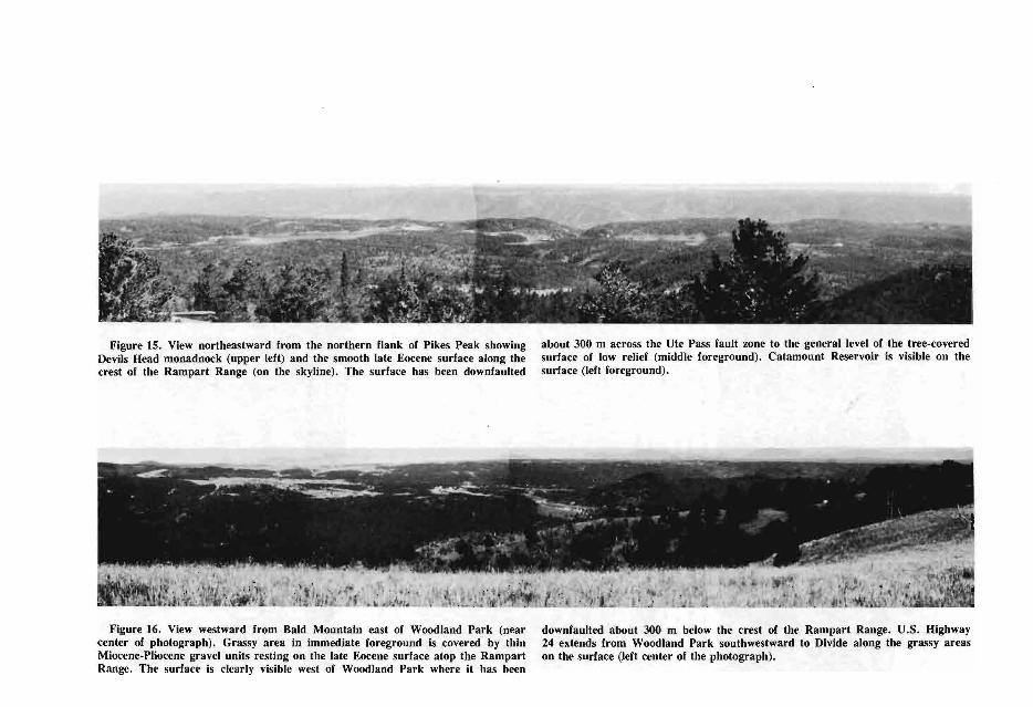
Figure IS. View northeastward from the northern flank of Pikes Peak showing Devils Head monadnock (upper left) and the smooth late Eocene surface along the crest of the Rampart Range (on the skyline). The surface has been downfaulted
Figure 16. View westward from Bald Mountain east of Woodland Park (near center of photograph). Grassy area in immediate foreground is covered by thin Miocene-Pliocene gravel units resting on the late Eocene surface atop the Rampart Range. The surface is clearly visible west of Woodland Park where it has been
about 300 m across the Ute Pass fault zone to the general level of the tree-covered surface of low relief (middle foreground). Catamount Reservoir is visible on the surface (left foreground).
downfaulted about 300 m below the crest of the Rampart Range. U.S. Highway 24 extends from Woodland Park southwestward to Divide along the grassy areas on the surface (left center of the photograph).
POST-LARAMIDE, LATE EOCENE EROSION SURFACE 63
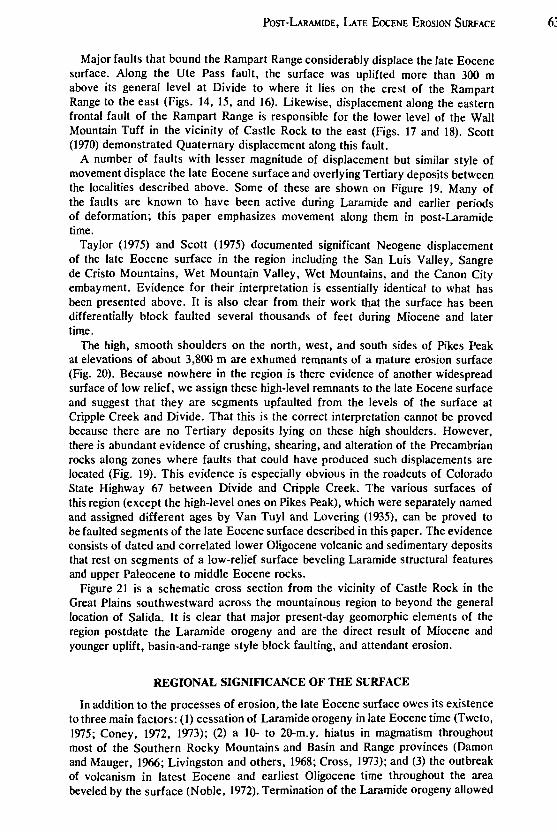
Major faults that bound the Rampart Range considerably displace the late Eocene surface. Along the Ute Pass fault, the surface was uplifted more than 300 m above its general level at Divide to where it lies on the crest of the Rampart Range to the east (Figs. 14, 15, and 16). Likewise, displacement along the eastern frontal fault of the Rampart Range is responsible for the lower level of the Wall Mountain Tuff in the vicinity of Castle Rock to the east (Figs. 17 and IS). Scott (1970) demonstrated Quaternary displacement along this fault.
A number of faults with lesser magnitude of displacement but similar style of movement displace the late Eocene surface and overlying Tertiary deposits between the localities described above. Some of these are shown on Figure 19. Many of the faults are known to have been active during Laramide and earlier periods of deformation; this paper emphasizes movement along them in post-Laramide time.
Taylor (1975) and Scott (1975) documented significant Neogene displacement of the late Eocene surface in the region including the San Luis Valley, Sangre de Cristo Mountains, Wet Mountain Valley, Wet Mountains, and the Canon City embayment. Evidence for their interpretation is essentially identical to what has been presented above. It is also clear from their work that the surface has been differentially block faulted several thousands of feet during Miocene and later time.
The high, smooth shoulders on the north, west, and south sides of Pikes Peak at elevations of about 3,800 m are exhumed remnants of a mature erosion surface (Fig. 20). Because nowhere in the region is there evidence of another widespread surface of low relief, we assign these high-level remnants to the late Eocene surface and suggest that they are segments upfaulted from the levels of the surface at Cripple Creek and Divide. That this is the correct interpretation cannot be proved because there are no Tertiary deposits lying on these high shoulders. However, there is abundant evidence of crushing, shearing, and alteration of the Precambrian rocks along zones where faults that could have produced such displacements are located (Fig. 19). This evidence is especially obvious in the roadcuts of Colorado State Highway 67 between Divide and Cripple Creek. The various surfaces of this region (except the high-level ones on Pikes Peak), which were separately named and assigned different ages by Van Tuy\ and Lovering (1935), can be proved to be faulted segments of the late Eocene surface described in this paper. The evidence consists of dated and correlated lower Oligocene volcanic and sedimentary deposits that rest on segments of a low-relief surface beveling Laramide structural features and upper Paleocene to middle Eocene rocks.
Figure 21 is a schematic cross section from the vicinity of Castle Rock in the Great Plains southwestward across the mountainous region to beyond the general location of Salida. It is clear that major present-day geomorphic elements of the region postdate the Laramide orogeny and are the direct result of Miocene and younger uplift, basin-and-range style block faulting, and attendant erosion.
REGIONAL SIGNIFICANCE OF THE SURFACE
In addition to the processes of erosion, the late Eocene surface owes its existence to three main factors: (1) cessation of Laramide orogeny in late Eocene time (Tweto, 1975; Coney, 1972, 1973); (2) a 10- to 20-m.y. hiatus in magmatism throughout most of the Southern Rocky Mountains and Basin and Range provinces (Damon and Mauger, 1966; Livingston and others, I%S; Cross, 1973); and (3) the outbreak of volcanism in latest Eocene and earliest Oligocene time throughout the area beveled by the surface (Noble, 1972). Termination of the Laramide orogeny allowed
64 EPIS AND CHAPIN
Figure 17. Oblique aerial view southward along the east frontal fault-line scarp of the Rampart Range showing Pikes Peak (right skyline) and the flat, late Eocene surface on the range upfaulted from the general level of the western Great Plains (left).
erosion to attack uplifts and fill basins without significant tectonic rejuvenation of topographic relief. The hiatus in volcanism allowed destructional geomorphic processes to alter the landscape uninterrupted by added shielding of constructional volcanic piles. Rapid weathering in a warm, temperate to sUbtropical climate and lateral planation by streams quickly reduced the landscape to a broad and open surface of subdued relief. Laramide uplifts were beveled and adjacent basins filled.
The nearly simultaneous outbreak of volcanism across much of the Southern Rocky Mountains and Basin and Range provinces in earliest Oligocene time preserved the surface beneath a mantle of volcanic and volcaniclastic rocks. Widespread units such as the Wall Mountain Tuff provide stratigraphic and structural datums by which the underlying surface can be reconstructed . Continuation of relatively stable tectonic conditions during middle Tertiary volcanism left the various volcanic fields and the underlying surface almost intact until regional extension and block faulting began in Miocene time. The present level of uplift and erosion in central Colorado is optimum for exposing the late Eocene surface across large areas and makes possible its documentation. The fact that the late Eocene surface is the only widespread low-relief surface that was developed and preserved in the Southern Rocky Mountains during Cenozoic time (Scott, 1975) suggests an unusual combination of events, such as the three listed above.
It is beyond the scope of this paper to attempt to trace the late Eocene surface to its farthest boundaries . It is worth noting, however, a few areas where additional work would probably unravel a story similar to that described here . Steven and Epis (1968) and Steven (1975) have shown that south-central Colorado and adjoining areas were covered by a large composite volcanic field of Oligocene and Miocene age that was disrupted by late Cenozoic block faulting and erosion. The largest and best known remnant of this composite field is the San Juan volcanic field, from which the Thirtynine Mile volcanic field has been isolated by faulting and erosion along the Rio Grande rift. The main portion of the San Juan volcanic field rests on a post-Laramide surface of low relief surrounding a residual Laramide topographic high in the Needle Mountains area (T. A. Steven, 1973, oral commun.) . In discussing the age of volcanic activity in the San Juan field, Steven and others (1967, p. D47) stated:

POST-LARAMIDE, LATE EOCENE EROSION SURFACE
This Tertiary volcanism occurred after a period of erosion had stripped the sedimentary rocks from the more highly upwarped areas. Streams responsible for much of this erosion deposited an apron of gravels , sands, and clays around the margins of the higher areas of exposed Precambrian rocks to form the Telluride and Blanco Basin Formations.
The surface beneath the San Juan field was referred to as the Telluride peneplain by Atwood and Mather (1932, p. 17) and as "the surface at the base of the volcanic rocks" by Larsen and Cross (1956, p. 245) . Atwood and Mather (1932, p. 16-18) stated the following about the prevolcanic late Eocene (Telluride) surface:
. .. we may picture the San Juan region at the end of the Telluride epoch as having a maximum relief of only 1,000 or 2,000 feet between the highest land near the center of the San Juan dome , where degradation would still be in progress , and the flat lowland built by aggradation on the flanks of the dome .. . . a region once rugged and mountainous had been reduced to rounded hills and low ridges , standing at only slight altitudes above an undulating plain.
The Blanco Basin Formation was deposited along the southern edge of the San Juan uplift in northern New Mexico and southern Colorado while the Telluride Conglomerate was deposited along the western edge of the uplift. Both formations (I) rest on a surface of low relief which truncates the upturned edges of Cretaceous and older rocks, (2) pinch out against the residual Laramide high near the center of the uplift, (3) contain little or no volcanic detritus, and (4) are overlain in a nearly conformable manner by basal e~rly Oligocene units of the San Juan volcanic field . The Telluride surface therefore is younger than the Late Cretaceous-early Paleocene Animas Formation (Larsen and Cross, 1956; Dane, 1946) and Cimarron Ridge Formation (66 m.y. old; Dickinson and others, 1968) and is older than the early Oligocene San Juan, Picayune, Lake Fork, and Conejos Formations that were erupted beginning about 35 m.y. ago (Lipman and others, 1970, 1973) . The age, or ages, of the Telluride and Blanco Basin Formations are as yet uncertain
Figure 18. Oblique aerial view of the late Eocene surface cut into Precambrian Pikes Peak Granite on top of the Rampart Range west of the U.S. Air Force Academy north of Colorado Springs. The steep east front of the range is the fault-line scarp of the Rampart Range fault.
65

Figure 19. Composite of Army Map Service plastic relief maps (2-degree quadrangles) showing principal normal faults along which the late Eocene surface has been block faulted. Bar and ball symbols indicate down thrown sides of faults. Dashed line is approximate location of schematic structure section shown in Figure 21. See Figures 1 and 2 for geographic references. Figure 9 shows the elevations of the Wall Mountain Tuff on most of the fault blocks.

POST-LARAMIDE, LATE EOCENE EROSION SURFACE
although several authors (Van Houten, 1957; Simpson, 1948; Dunn, 1964) correlated them on the basis of lithology and stratigraphic position with the San Jose Formation of early Eocene age in the central San Juan basin. The prevolcanic, late Eocene surface must have developed on the upper surfaces of these formations following aggradation of the downwarps in which the formations accumulated. As in the Thirtynine Mile volcanic field and elsewhere, the smoothness of the late Eocene surface is the result of both erosion of uplifts and concomitant aggradation of basins.
In several areas around the eroded periphery of the San Juan volcanic field, large expanses of the prevolcanic surface have been exhumed, and sufficient patches of volcanic and sedimentary rocks remain to encourage dating and reconstruction of the surface. The most promising areas are (1) along the crest of the Tusas Mountains in northern New Mexico (Butler, 1946, 1971; Bingler, 1968; Muehlberger, 1967, 1968), (2) along the crest of the Sangre de Cristo Range in northern New Mexico and southern Colorado (McKinlay, 1956, 1957; Ray and Smith, 1941; Smith and Ray, 1943; Clark and Read, 1972; Pill more and others, 1973), and (3) between the San Juan and West Elk Mountains where the once continuous volcanic field has been deeply dissected by the Gunnison River and its tributaries (Larsen and Cross, 1956; Olson and others, 1968; Hansen, 1965, 1971; Lipman and others, 1969). Many of the above authors have made reference to erosion surfaces and the occurrence of high-level gravel units beneath, and interbedded with, volcanic rocks correlative with those of the San Juan volcanic field . Interpretations differ, however, as to their age and significance. We suggest that detailed mapping, accompanied by additional dating and correlation of the volcanic rocks and compositional studies of the interbedded gravel units, will demonstrate that the age and geomorphic character of the pre volcanic surface in these areas are similar to those of the late Eocene surface described in this paper.
Scott (1975) suggested that it may be possible to trace the late Eocene surface
Figure 20. View southeastward from Wilkerson Pass across the low, grass-covered portion of the Florissant basin (center) toward Pikes Peak. The late Eocene surface has been upfauJted from the Florissant basin to a level about midway between the basin and timberline, from where the surface extends southward (right) beyond the view of the photograph beneath the Cripple Creek volcanic field. The high smooth surface at about 3,800 m on the north, west, and south shoulders of Pikes Peak is clearly visible above timberline. Even though no confirming Cenozoic deposits have been found there, this surface is interpreted as a remnant of the late EOCene surface faulted even higher above the levels of the Florissant basin and the Cripple Creek volcanic field.
67
68 EPIS AND CHAPIN
northward from the Thirtynine Mile volcanic field along the Front Range of Colorado into southern Wyoming on the basis of studies by Knight (1953), Soister (1968), Harshman (1968), and Denson and Harshman (1969). Dating and correlation of the surface in this area are handicapped by the scarcity of volcanic rocks, and its reconstruction must depend heavily on studies of the composition and distribution of gravel units and on geomorphic and structural interpretations.
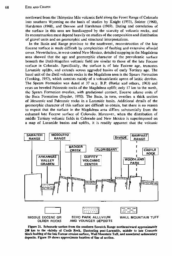
In the Basin and Range province to the southwest, reconstruction of the late Eocene surface is made difficult by complexities of faulting and extensive alluvial cover. Nevertheless, in west-central New Mexico, detailed mapping in the Magdalena area showed that the age and geomorphic character of the pre volcanic surface beneath the Datil-Mogollon volcanic field are similar to those of the late Eocene surface in Colorado. Specifically, the surface is of late Eocene age, truncates Laramide uplifts, and extends across aggraded basins of early Tertiary age. The basal unit of the Datil volcanic rocks in the Magdalena area is the Spears Formation (Tonking, 1957), which consists mainly of a volcaniclastic apron of latitic detritus. The Spears Formation was dated at 37 m.y. B.P. (Burke and others, 1963) and rests on beveled Paleozoic rocks of the Magdalena uplift; only 17 km to the north, the Spears Formation overlies, with gradational contact, Eocene arkose units of the Baca Formation (Snyder, 1970). The Baca, in turn, overlies a thick section of Mesozoic and Paleozoic rocks in a Laramide basin. Additional details of the geomorphic character of this surface are difficult to obtain, but there is no reason to expect that the surface in the Magdalena area differs substantially from the exhumed late Eocene surface of Colorado. Moreover, when the distribution of middle Tertiary volcanic fields in Colorado and New Mexico is superimposed on a map of Laramide basins and uplifts, it is readily apparent that the volcanic
MIDDLE EOCENE OR OLDER ROCKS
I DIVIDE I '--'T'-=-==---
t t ... ~
1" .... "·1 ............ .. .. .. .. .. .. .. ..
ECHO PARK ALLUVIUM AND YOUNGER DEPOSITS
1=---1 WALL MOUNTAIN TUFF
Figure 21. Schematic section from the southern Sawatch Range northeastward approximately 200 Ian to the vicinity of Castle Rock, illustrating post-Laramide, middle to late Cenozoic block faulting of the late Eocene erosion surface, Wall Mountain Tuff, and associated sedimentary deposits. Figure 19 shows approximate location of line of section.
POST-LARAMIDE, LATE EOCENE EROSION SURFACE 69
piles spread across both beveled uplifts and adjacent aggraded basins. If volcanic materials were able to blanket uplifts and basins alike, there must have been a widespread surface of low relief. In contrast, late Cenozoic volcanic rocks are confined largely to basins because pronounced topographic relief generally accompanied the structural relief in late Cenozoic time.
The existence and economic significance of a middle Tertiary erosion surface of regional extent has long been recognized in the porphyry copper province of southern Arizona and southwestern New Mexico. More than 40 years ago, Harrison Schmitt (1933, p. 321-322) wrote:
... most of the country was attacked by erosion as soon as it was elevated above the sea. This produced the well known Eocene (and Oligocene) peneplain and erosion surface of continental extent, and recognized from southwestern Colorado southward along the Arizona-New Mexico line to the Mexican border. It is covered by a thick series of intermediate to acid volcanic rocks, believed to be of Miocene-Pliocene age; and by coarse continental conglomerates, lake beds, and boIs on deposits dated Miocene, Pliocene, and Pleistocene.
Schmitt's observations were made nearly three decades before K-Ar ages became widely available and before numerous detailed studies of Cenozoic volcanic rocks were accomplished. Yet all that is necessary to update his statement is to delete the word "peneplain," substitute "regional" for "continental," and adjust the age of the Tertiary volcanic rocks to begin in the Oligocene.
P. E. Damon and his associates at the University of Arizona have documented the bimodal distribution with reference to time of Cenozoic magmatism in the Basin and Range province (Damon and Mauger, 1%6; Livingston and others, 1%8). The to-m.y. hiatus in magmatism that is responsible for the bimodal distribution coincides with the time of carving of the late Eocene erosion surface. Livingston and others (1968) pointed out that most of the Laramide porphyry copper deposits of Arizona were eroded, leached, and enriched during this quiescent period; were then buried by volcanic and sedimentary rocks of middle and late Cenozoic age; and today have been, or are being, exhumed from beneath this cover. The youngest of these prophyry copper deposits (52 to 55 m.y. old; Livingston, 1973) was emplaced in latest Paleocene-earliest Eocene time. The onset of middle Tertiary volcanism that buried the deposits was nearly contemporaneous with the beginning of volcanism in the Thirtynine Mile, San Juan, and Datil-Mogollon volcanic fields. It seems certain, therefore, that fundamental patterns of tectonism, magmatism, and geomorphic evolution are similar in the Cenozoic history of both the southern Rocky Mountains and Basin and Range provinces_ The late Eocene erosion surface may provide a structural datum by which these histories can be more clearly understood.
ACKNOWLEDGMENTS
We wish to acknowledge the many benefits derived from field and office discussions with graduate students who have worked with us at the Colorado School of Mines and the New Mexico Institute of Mining and Technology (see theses listed below) and with P. W. Lipman, G. R. Scott, T. A. Steven, R. B. Taylor, R. E. Van Alstine, and C. T. Wrucke of the U.S. Geological Survey. We are indebted to J. D. Obradovich of the U.S. Geological Survey who has kindly given us permission to publish several new radiometric dates. The work of G. R. Scott and R. B. Taylor has been especially helpful in our analysis of the erosion surface.

70 EPIS AND CHAPIN
BIBLIOGRAPHY
Atwood, W. W., and Mather, K. F., 1932, Physiography and Quaternary geology of the San Juan Mountains, Colorado: U.S. Geo!. Survey Prof. Paper 166, 176 p.
Bingler, E. C., 1968, Geology and mineral resources of Rio Arriba County, New Mexico: New Mexico Bur. Mines and Mineral Resources Bull. 91, 158 p.
Brown, R. W., 1943, Cretaceous-Tertiary boundary in the Denver basin, Colorado: Geo!. Soc. America Bull., v. 54, p. 65-86.
--1%2, Paleocene flora of the Rocky Mountains and Great Plains: U.S. Geo!. Survey Prof. Paper 375, 119 p.
Buchanan, P. H., 1%7, Volcanic geology of the Guffey area, Park County, Colorado [M. Sc. thesis]: Golden, Colorado School of Mines, 95 p.
Burbank, W. S., and others, compilers, 1935, Geologic map of Colorado: U.S. Geo!. Survey, in cooperation with Colorado State Geo!. Survey Board and Colorado Metal Mining Fund, scale 1:500,000.
Burke, W. H., Kenny, G. S., OUo, J. B., and Walker, R. D., 1963, Potassium-argon dates, Socorro and Sierra Counties, New Mexico, in New Mexico Geo!. Soc. Guidebook 14th Field Conf., Socorro region, 1963: p. 224.
Butler, A. P., Jr., 1946, Tertiary and Quaternary geology of the Tusas-Tres Piedras area, New Mexico [Ph.D. thesis]: Cambridge, Mass., Harvard Univ., 188 p.
--1971, Tertiary volcanic stratigraphy of the eastern Tusas Mountains, southwest of the San Luis Valley, Colorado-New Mexico, in New Mexico Geo!. Soc. Guidebook 22nd Field Conf., San Luis Basin, 1971: p. 289-300.
Chapin, C. E., 1%5, Geologic and petrologic features of the Thirtynine Mile volcanic field, central Colorado [D. Sc. thesis]: Golden, Colorado School of Mines, 176 p.
--1971, The Rio Grande rift, Pt. I: Modifications and additions, in New Mexico Geo!. Soc. Guidebook 22nd Field Conf., San Luis Basin, 1971: p. 191-201.
Chapin, C. E., and Epis, R. C., 1964, Some stratigraphic and structural features of the Thirtynine Mile volcanic field, central Colorado: Mtn. Geologist, v. I, no. 3, p. 145-160.
Chapin, C. E., and Wyckoff, B. S., 1%9, Formation of the 60-cubic-mile andesitic breccia sheet in the Thirtynine Mile volcanic field of central Colorado: Geo!. Soc. America, Abs. for 1968, Spec. Paper 121, p. 52.
Chapin, C. E., Epis, R. C., and Lowell, G. R., 1970, Late Eocene paleovalleys and Oligocene volcanic rocks along the upper Arkansas Valley segment of the Rio Grande rift zone in Colorado [abs.J, in The Rio Grande depression, New Mexico and Colorado: New Mexico Geo!. Soc., Program (24th Ann. Mtg.), p. 6.
Clark, K. F., and Read, C. B., 1972, Geology and ore deposits of Eagle Nest area, New Mexico: New Mexico Bur. Mines and Mineral Resources Bull. 94, 152 p.
Coney, P. J., 1972, Cordilleran tectonics and North American plate motion: Am. Jour. Sci., v. 272, p. 603-628.
--1973, Non-collision tectogenesis in western North American, in Tarling, D. H., and Runcorn, S. K., eds., Implications of continental drift to the earth sciences: New York, Academic Press, p. 713-727.
Cross, T. A., 1973, Implications of igneous activity for the early Cenozoic tectonic evolution of western United States: Geo!. Soc. America, Abs. with Programs (Ann. Mtg.), v. 5, no. 7. p. 587.
Cross, Whitman, 1894, Description of Pikes Peak sheet, Colorado: U.S. Geo!. Survey Geo!. Atlas, Folio 7, 8 p., 5 maps.
Damon, P. E., and Mauger, R. L., 1966, Epeirogeny-orogeny viewed from the Basin and Range province: Soc. Mining Engineers Trans., v. 235, p. 99-112.
Dane, C. H., 1946, Stratigraphic relations of Eocene, Paleocene, and latest Cretaceous formations of eastern side of San Juan basin, New Mexico: U.S. Geo!. Survey Oil and Gas Inv. Prelim. Chart 24.
Denson, N. M., and Harshman, E. N., 1%9, Map showing areal distribution of Tertiary rocks, Bates Hole-Shirley Basin area, south-centraJ Wyoming: U.S. Geo!. Survey Misc. Geo!. Inv. Map 1-570, scale 1:125,000.

POST-LARAMIDE, LATE EOCENE EROSION SURFACE
De Voto, R. H., 1961, Geology of southwestern South Park, Park and Chaffee Counties. Colorado [D. Sc. thesis]: Golden. Colorado School of Mines. 323 p.
--1964. Stratigraphy and structure of Tertiary rocks in southwestern South Park: Mtn. Geologist. v. I. no. 3. p. 117-126.
--1971. Geologic history of South Park and geology of the Antero Reservoir quadrangle. Colorado: Colorado School Mines Quart., v. 66. no. 3,90 p.
Dickinson, R. G., Leopold, E. B., and Marvin, R. F .• 1968. Late Cretaceous uplift and volcanism on the north flank of the San Juan Mountains. Colorado. in Epis. R. C .• ed., Cenozoic volcanism in the southern Rocky Mountains: Colorado School Mines Quart.. v. 63, no. 3, p. 125-148.
Dings. M. G .• and Robinson, C. S., 1957, Geology and ore deposits of the Garfield quadrangle. Colorado: U.S. Geol. Survey Prof. Paper 289, 110 p.
Dott, R. H., Jr., and Batten. R. L., 1971, Evolution of the earth: New York, McGraw-Hill, 649 p.
DuHamel, J. E., 1968. Volcanic geology of the upper Cottonwood Creek area, Thirtynine Mile volcanic field [M. Sc. thesis]: Golden, Colorado School of Mines, 120 p.
Dunn, D. E., 1964. Evolution of the Chama Basin and Archuleta anticlinorium, eastern Archuleta County, Colorado [Ph.D. thesis]: Austin, Univ. Texas, 112 p.
Epis, R. C., and Chapin. C. E., 1968, Geologic history of the Thirtynine Mile volcanic field. central Colorado, in Epis, R. C., ed., Cenozoic volcanism in the southern Rocky Mountains: Colorado School Mines Quart., v. 63, no. 3, p. 51-85.
--1974, Stratigraphic nomenclature of the Thirtynine Mile volcanic field, central Colorado: U.S. Geol. Survey Bull. 1395-C, 23 p.
Graebner. Peter, 1%7, Remanent magnetism in major rock units of the Thirtynine Mile volcanic field, central Colorado [M. Sc. thesis]: Golden, Colorado School of Mines, 165 p.
Graebner, Peter, and Epis, R. c.. 1968, Remanent magnetism in major rock units of the Thirtynine Mile volcanic field, central Colorado [abs.J, in Epis, R. C., ed .• Cenozoic volcanism in the southern Rocky Mountains: Colorado School Mines Quart., v. 63, no. 3, p. 87-88.
Hansen, W. R., 1965, The Black Canyon of the Gunnison. today and yesterday: U.S. Geol. Survey Bull. 1191,76 p.
--1971, Geologic map of the Black Canyon of the Gunnison River and vicinity, western Colorado: U.S. Geol. Survey Misc. Geol. Inv. Map 1-584, scale 1:31,680.
Harland, W. B., Smith. A. G., and Wilcock, Bruce, eds .• 1964, The Phanerozoic time scale-A symposium dedicated to Professor Arthur Holmes: Geol. Soc. London Quart. Jour. Supp .• v. 120s, 458 p.
Harshman, E. N .• 1%8, Geologic map of the Shirley Basin area. Albany, Carbon. Converse. and Natrona Counties, Wyoming: U.S. Geol. Survey Misc. Geol. Inv. Map 1-539, scale 1:48,000.
Hawley, C. C., 1%9. Geology and beryllium deposits of the Lake George (or Badger Flats) beryllium area. Park and Jefferson Counties, Colorado: U.S. Geol. Surv. Prof. Paper 608-A. 44 p.
Izett, G. A .• Scott, G. R .• and Obradovich, J. D., 1%9, Oligocene rhyolite in the Denver Basin, Colorado. in Geological Survey research 1%9: U.S. Geol. Survey Prof. Paper 650-B. p. BI2-BI4.
Johnson. J. H .• 1935, Stratigraphy of northeastern and east-central parts of South Park, Colorado: Am. Assoc. Petroleum Geologists Bull., v. 19, p. 1339-1356.
--1937a, Algae and algal limestones from the Oligocene of South Park, Colorado: Geol. Soc. America Bull., v. 48, p. 1227-1235.
--1937b, The Tertiary deposits of South Park, Colorado [abs.]: Colorado Univ. Studies. v. 25, no. 1, p. 77.
--1937c, Tertiary deposits of South Park, Colorado, with a description of Oligocene algal limestones [Ph.D. thesis]: Boulder, Colorado Univ., 68 p.
Johnson, R. B., 1959, Geology of the Huerfano Park area, Huerfano and Custer Counties, Colorado: U.S. Geol. Survey Bull. I071-D, p. 87-119.
71
72 EPIS AND CHAPIN
Johnson, R. B., and Wood, G. H., 1956, Stratigraphy of Upper Cretaceous and Tertiary rocks of Raton basin, Colorado and New Mexico: Am. Assoc. Petroleum Geologists, v. 40, no. 4, p. 707-721.
Knight, S. H., 1953, Summary of the Cenozoic history of the Medicine Bow Mountains, Wyoming: Wyoming Geol. Assoc. Guidebook 8th Ann. Field Conf., Laramie Basin, Wyoming, and North Park, Colorado, 1953: p. 65-76.
Larsen, E. S., Jr., and Cross, Whitman, 1956, Geology and petrology of the San Juan region, southwestern Colorado: U.S. Geol. Surv. Prof. Paper 258, 303 p.
Leopold, E. B., and MacGinitie, H. D., 1972, Development and affinities of Tertiary floras in the Rocky Mountains: in Aham, A. G., Floristics and paleofloristics of Asia and eastern North America: Amsterdam, Elsevier Pub. Co., chap. 12, p. 147-200.
Lipman, P. W., Mutschler, F. E., Bryant, Bruce, and Steven, T. A., 1969, Similarity of Cenozoic igneous activity in the San Juan and Elk Mountains, Colorado, and its regional significance, in Geological survey research 1969: U.S. Geol. Survey Prof. Paper 650-D, p.033-042.
Lipman, P. W., Steven, T. A., and Mehnert, H. H., 1970, Volcanic history of the San Juan Mountains, Colorado, as indicated by potassium-argon dating: Geol. Soc. America Bull, v. 81, p. 2329-2352.
Lipman, P. W., Steven, T. A., Luedke, R. G., and Burbank, W. S., 1973, Revised volcanic history of the San Juan, Uncompahgre, Silverton, and Lake City calderas in the western Sanjuan Mountains, Colorado: U.S. Geol. Survey Jour. Research, v. 1, no. 6, p. 627-642.
Livingston, D. E., 1973, A plate tectonic hypothesis for the genesis of prophyry copper deposits of the southern Basin and Range province: Earth and Planetary Sci. Letters, v. 20, p. 171-179.
Livingston, D. E., Mauger, R. L., and Damon, P. E., 1968, Geochronology of the emplacement, enrichment, and preservation of Arizona prophyry copper deposits: Econ. Geology, v. 63, p. 30-36.
Lowell, G. R., 1969, Geologic relationships of the Salida area to the Thirtynine Mile volcanic field of central Colorado [D. Sc. thesis]: Socorro, New Mexico Inst. Mining and Technology, 113 p.
--1971, Cenozoic geology of the Arkansas Hills region of the southern Mosquito Range, central Colorado, in New Mexico Geol. Soc. Guidebook 22nd Field Cont., San Luis Basin, 1971: p. 209-217
Lowell, G. R., and Chapin, C. E., 1972, Primary compaction and flow foliation in ash-flow tuffs of the Gribbles Run paleovalley, central Colorado: Geol. Soc. America, Abs. with Program (Ann. Mtg.), v. 4, no. 7, p. 725-726.
Lozano, Efraim, 1965, Geology of the southwestern Garo area, South Park, Park County, Colorado [M. Sc. thesis]: Golden, Colorado School of Mines, 1I5 p.
MacGinitie, H. D., 1953, Fossil plants of the Florissant beds, Colorado: Carnegie Inst. Washington Pub. 599, Contr. Paleontology, 198 p.
McKinlay, P. F., 1956, Geology of Costilla and Latir Peak quadrangles, Taos County, New Mexico: New Mexico Bur. Mines and Mineral Resources Bull. 42, 32 p.
--1957, Geology of Questa quadrangle, Taos County, New Mexico: New Mexico Bur. Mines and Mineral Resources Bull. 53, 23 p.
Morris, Gary R., 1969, Geology of the Dicks Peak area, Park County, Colorado [M. Sc. thesis]: Golden, Colorado School of Mines, 69 p.
Muehlberger, W. R., 1967, Geology of the Chama quadrangle, New Mexico: New Mexico Bur. Mines and Mineral Resources Bull. 89, 114 p.
--1968, Geology of Brazos Peak quadrangle, New Mexico: New Mexico Bur. Mines and Mineral Resources Geol. Map 22, scale 1:48,000.
Niesen, P. L., 1969, Stratigraphic relationships of the Florissant Lake Beds to the Thirtynine Mile volcanic field of central Colorado [M. Sc. thesis]: Socorro, New Mexico Inst. Mining and Technology, 65 p.
Noble, D. C., 1972, Some observations on the Cenozoic volcano-tectonic evolution of the Great Basin, western United States: Earth and Planetary Sci. Letters, v. 17, p. 142-150.
Olson, J. C., Hedlund, D. C., and Hansen, W. R., 1968, Tertiary volcanic stratigraphy

POST-LARAMIDE, LATE EOCENE EROSION SURFACE 73
in the Powderhorn-Black Canyon region, Gunnison and Montrose Counties, Colorado: U.S. Geo!. Survey Bull. 1251-C, p. CI-C29.
Pillmore, C. L., Obradovich, J. D., Landreth, J. 0., and Pugh, L. E., 1973, Mid-Tertiary volcanism in the Sangre de Cristo Mountains of northern New Mexico: Geo!. Soc. America, Abs. with Programs (Rocky Mtn. Sec.), v. 5, no. 6, p. 502.
Ray, L. L., and Smith, J. F., Jr., 1941, Geology of the Moreno Valley, New Mexico: Geo!. Soc. America Bull., v. 52, p. 177-210.
Richardson, G. B., 1915, Description of the Castle Rock quadrangle, Colorado: U.S. Geo!. Survey Geo!. Atlas, Folio 19S, 13 p.
Sawatzky, D. L., 1964, Structural geology of southeastern South Park, Park County, Colorado: Mtn. Geologist, v. I, no. 3, p. 133-139.
--1967, Tectonic style along the Elkhorn thrust, eastern South Park and western Front Range, Park County, Colorado [D. Sc. thesis]: Golden, Colorado School of Mines, 206 p.
Schmitt, H., 1933, Summary of the geological and metallogenetic history of Arizona and New Mexico, in Ore Deposits of the Western States: New York, Am. Inst. Mining and Metal!. Engineers, p. 316-326.
Scott, G. R., 1970, Quaternary faulting and potential earthquakes in east-central Colorado: U.S. Geo!. Survey Prof. Paper 700-C, p. ClI-CIS.
--1975, Cenozoic surfaces and deposits in the Southern Rocky Mountains, in Curtis, Bruce, ed., Cenozoic history of the Southern Rocky Mountains: Geo!. Soc. America Mem. 144, p. 227-248.
Scott, G. R., and Taylor, R. B., (1975), Post-Paleocene Tertiary rocks and Quaternary volcanic ash of the Wet Mountain Valley, Colorado: U.S. Geo!. Survey Prof. Paper (in press).
Simpson, G. G., 1945, The Eocene of the San Juan basin, New Mexico: Am. Jour. Sci., v. 246, no. 5, p. 247-282; v. 246, no. 6, p. 363-385.
Smith, 1. F., Jr., and Ray, L. L., 1943, Geology of the Cimarron Range, New Mexico: Geo\. Soc. America Bull., v. 54, p. 891-924.
Snyder, D.O., 1970, Fossil evidence of Eocene age of Baca Formation, New Mexico: New Mexico Geo\. Soc. Guidebook 21st Field Conf., Tyrone-Big Hatchet Mountains-Florida Mountains region, 1970: p. 65-67.
Soister, P. E., 1968, Stratigraphy of the Wind River Formation in south-central Wind River Basin, Wyoming: U.S. Geo!. Survey Prof. Paper 594-A, p. A1-A50.
Stark, 1. T., and others, 1949, Geology and origin of South Park, Colorado: Geo!. Soc. America Mem. 33, 188 p.
Steven, T. A., 1975, Middle Tertiary volcanic field in the Southern Rocky Mountains, in Curtis, Bruce, ed., Cenozoic history of the Southern Rocky Mountains: Geo!. Soc. America Mem. 144, p. 75-94.
Steven, T. A., and Epis, R. C., 1968, Oligocene volcanism in south-central Colorado, ill Epis, R. C., ed., Cenozoic volcanism in the southern Rocky Mountains: Colorado School Mines Quart., v. 63, no. 3, p. 241-258.
Steven, T. A., Mehnert, H. H., and Obradovich, J. D., 1967, Age of volcanic activity in the San Juan Mountains, Colorado, in Geological Survey research 1967: U.S. Geo!. Survey Prof. Paper 575-D, p. 047-D55.
Taylor, R. B., 1975, Neogene tectonism in south-central Colorado in Curtis, Bruce, ed., Cenozoic history of the Southern Rocky Mountains: Geo\. Soc. America Mem. 144, p.211-226.
Tobey, E. F., 1969, Geologic and petrologic relationships between the Thirtynine Mile volcanic field and the Cripple Creek volcanic center [M. Sc. thesis]: Socorro, New Mexico Inst. Mining and Technology, 61 p.
Tonking, W. H., 1957, Geology of the Puertocito quadrangle, Socorro County, New Mexico: New Mexico Bur. Mines and Mineral Resources Bull. 41, 67 p.
TWeto, Ogden, 1961, Late Cenozoic events of the Leadville district and upper Arkansas Valley, Colorado, in Short papers in the geologic and hydrologic sciences: U.S. Geo!. Survey Prof. Paper 424-B, p. BI33-B135.
--1975, Laramide (Late Cretaceous-early Tertiary) orogeny in the Southern Rocky Moun-
74 EplS AND CHAPIN
tains, in Curtis, Bruce, ed., Cenozoic history of the Southern Rocky Mountains: Geol. Soc. America Mem 144, p. 1-44.
Tweto, Ogden, and Case, J. E., 1972, Gravity and magnetic features as related to geology in the Leadville 30-minute quadrangle, Colorado: U.S. Geol. Survey Prof. Paper 726-C, 31 p.
Van Alstine, R. E., 1%9, Geology and mineral deposits of the Poncha Springs NE quadrangle, Chaffee County, Colorado: U.S. Geol. Survey Prof. Paper 626,52 p.
Van Houten, F. B., 1957, Appraisal of Ridgway and Gunnison "tillites," southwestern Colorado: Geol. Soc. America Bull., v. 68, p. 383-388.
Van Tuyl, F. M., and Lovering, T. S., 1935, Physiographic development of the Front Range: Geol. Soc. America Bull., v. 46, p. 1291-1350.
Welsh, Fred, 1969, The geology of the Castle Rock area, Douglas County, Colorado [M. Sc. thesis]: Golden, Colorado School Mines, 93 p.
Wyckoff, B., 1%9, Geology of the east side of the Guffey volcanic center, Park County, Colorado [M. Sc. thesis]: Socorro, New Mexico Inst. Mining and Technology, 64 p.
MANUSCRIPT RECEIVED BY THE SOCIETY MAY 8, 1974
Printed in U.S.A.