geomedia feature topographer - hexagon geospatialcommunity.hexagongeospatial.com/hmrkh95973/... ·...
TRANSCRIPT
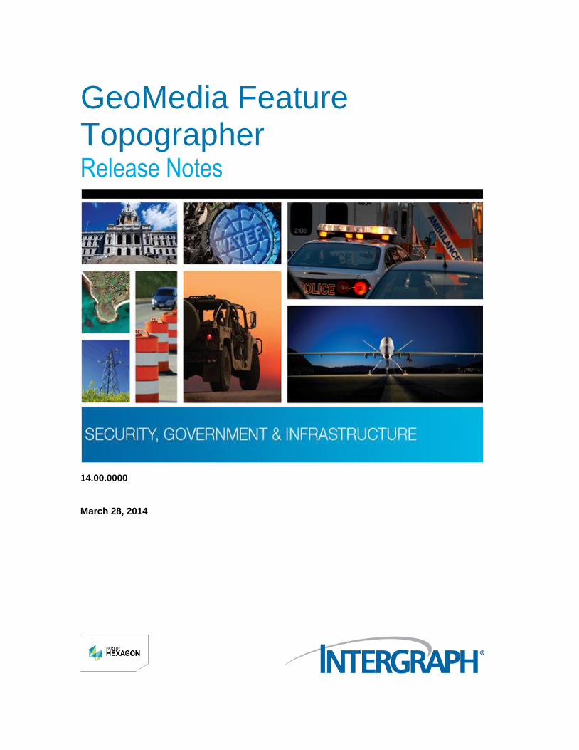
GeoMedia Feature Topographer Release Notes
14.00.0000
March 28, 2014

Copyright
Copyright © 2005-2014 Intergraph® Corporation. All Rights Reserved. Intergraph is part of Hexagon.
Including software, file formats, and audiovisual displays; may be used pursuant to applicable software license agreement; contains confidential and proprietary information of Intergraph and/or third parties which is protected by copyright law, trade secret law, and international treaty, and may not be provided or otherwise made available without proper authorization from Intergraph Corporation.
U.S. Government Restricted Rights Legend
Use, duplication, or disclosure by the government is subject to restrictions as set forth below. For civilian agencies: This was developed at private expense and is "restricted computer software" submitted with restricted rights in accordance with subparagraphs (a) through (d) of the Commercial Computer Software - Restricted Rights clause at 52.227-19 of the Federal Acquisition Regulations ("FAR") and its successors, and is unpublished and all rights are reserved under the copyright laws of the United States. For units of the Department of Defense ("DoD"): This is "commercial computer software" as defined at DFARS 252.227-7014 and the rights of the Government are as specified at DFARS 227.7202-3.
Unpublished - rights reserved under the copyright laws of the United States.
Intergraph Corporation P.O. Box 240000 Huntsville, AL 35813
Terms of Use
Use of this software product is subject to the End User License Agreement ("EULA") delivered with this software product unless the licensee has a valid signed license for this software product with Intergraph Corporation. If the licensee has a valid signed license for this software product with Intergraph Corporation, the valid signed license shall take precedence and govern the use of this software product. Subject to the terms contained within the applicable license agreement, Intergraph Corporation gives licensee permission to print a reasonable number of copies of the documentation as defined in the applicable license agreement and delivered with the software product for licensee's internal, non-commercial use. The documentation may not be printed for resale or redistribution.
Warranties and Liabilities
All warranties given by Intergraph Corporation about equipment or software are set forth in the EULA provided with the software or applicable license for the software product signed by Intergraph Corporation, and nothing stated in, or implied by, this document or its contents shall be considered or deemed a modification or amendment of such warranties. Intergraph believes the information in this publication is accurate as of its publication date.
The information and the software discussed in this document are subject to change without notice and are subject to applicable technical product descriptions. Intergraph Corporation is not responsible for any error that may appear in this document.
The software discussed in this document is furnished under a license and may be used or copied only in accordance with the terms of this license. No responsibility is assumed by Intergraph for the use or reliability of software on equipment that is not supplied by Intergraph or its affiliated companies. THE USER OF THE SOFTWARE IS EXPECTED TO MAKE THE FINAL EVALUATION AS TO THE USEFULNESS OF THE SOFTWARE IN HIS OWN ENVIRONMENT.
Intergraph is not responsible for the accuracy of delivered data including, but not limited to, catalog, reference and symbol data. Users should verify for themselves that the data is accurate and suitable for their project work.
Trademarks
Intergraph, the Intergraph logo, and GeoMedia are registered trademarks of Intergraph Corporation. Hexagon and the Hexagon logo are registered trademarks of Hexagon AB or its subsidiaries. Microsoft and Windows are registered trademarks of Microsoft Corporation. Bing is a trademark of Microsoft Corporation. Google Maps is a trademark of Google Incorporated. Pictometry Intelligent Images is a registered trademark of Pictometry International Corporation. ERDAS, ERDAS IMAGINE, Stereo Analyst, IMAGINE Essentials, IMAGINE Advantage, IMAGINE Professional, IMAGINE VirtualGIS, Mapcomposer, Viewfinder, and Imagizer are registered trademarks of Intergraph Corporation.
Other brands and product names are trademarks of their respective owners.


GeoMedia Feature Topographer Release Notes 5
Contents About this Release ...................................................................................................................................... 7
Enhancements ............................................................................................................................................. 7
Ribbon Bar (GI-14) .................................................................................................................................. 7 Renamed Commands (GI-608) ............................................................................................................... 8 Feature Topographer Command Mapping ............................................................................................. 8 Intergraph Setup Manager Installation .................................................................................................. 10 MGCP (v4.0) (CR 1-67EAYU) .............................................................................................................. 11 Toggle FCT Tab .................................................................................................................................... 11 Reset Documentation (GI-2978) ........................................................................................................... 12 Resize Toolbar fields (CR 1-7XQB1K) ................................................................................................. 12 Collapse area to point (CR 1-6KUJGI) ................................................................................................. 13
Deletions..................................................................................................................................................... 13
Documentation .......................................................................................................................................... 13
Hardware Requirements ........................................................................................................................... 14

Contents
6 GeoMedia Feature Topographer Release Notes

GeoMedia Feature Topographer Release Notes 7
This document describes the enhancements for GeoMedia Feature Topographer 14.00.0000. Although the information in this document is current as of the product release, see the Intergraph Support Web site (https://sgisupport.intergraph.com/infocenter/index?page=home) for the most current version.
This release includes enhancements. For information on fixes that were made to GeoMedia Feature Topographer for this release, see the Issues Resolved report on the Intergraph Support Web site (https://sgisupport.intergraph.com/infocenter/index?page=home) for a specific product.
This document is only an overview and does not provide all of the details about the product's capabilities. See the online Help and other documents provided with GeoMedia Feature Topographer or GeoMedia Pro for more information.
Ribbon Bar (GI-14)
Ribbon User Interface
GeoMedia Feature Topographer allows you to use either of two Graphic User Interface (GUI) modes, the classic mode (up to Version 6.1) and the new ribbon mode. The classic mode provides the standard menu-based command interface. The ribbon provides the new ribbon and tab user interface. You can operate in whichever mode you feel more comfortable using, but you cannot run both modes simultaneously on the same machine.
The classic version will not be delivered after this release.
Ribbon Mnemonics and Access Keys
Ribbon mnemonics and access keys define the keyboard shortcuts and their associated workflow behavior in the ribbon mode at the tab and command levels.
About this Release
Enhancements
Enhancements
8 GeoMedia Feature Topographer Release Notes
Expanded Tooltips
You can display tooltips with expanded text describing a selected command by hovering your cursor over the command ribbon button.
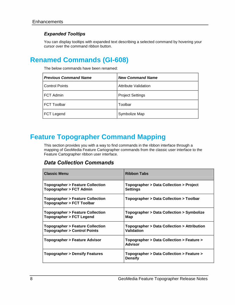
Renamed Commands (GI-608) The below commands have been renamed:
Previous Command Name New Command Name
Control Points Attribute Validation
FCT Admin Project Settings
FCT Toolbar Toolbar
FCT Legend Symbolize Map
Feature Topographer Command Mapping This section provides you with a way to find commands in the ribbon interface through a mapping of GeoMedia Feature Cartographer commands from the classic user interface to the Feature Cartographer ribbon user interface.
Data Collection Commands
Classic Menu Ribbon Tabs
Topographer > Feature Collection Topographer > FCT Admin
Topographer > Data Collection > Project Settings
Topographer > Feature Collection Topographer > FCT Toolbar
Topographer > Data Collection > Toolbar
Topographer > Feature Collection Topographer > FCT Legend
Topographer > Data Collection > Symbolize Map
Topographer > Feature Collection Topographer > Control Points
Topographer > Data Collection > Attribution Validation
Topographer > Feature Advisor Topographer > Data Collection > Feature > Advisor
Topographer > Densify Features Topographer > Data Collection > Feature > Densify

Enhancements
GeoMedia Feature Topographer Release Notes 9
Accuracy Commands
Classic Menu Ribbon Tabs
Topographer > Accuracy Measurement Tool > Configure Settings
Topographer > Accuracy > Configure
Topographer > Accuracy Measurement Tool > Place Feature Points
Topographer > Accuracy > Place Points > Feature
Topographer > Accuracy Measurement Tool > Place Image Points
Topographer > Accuracy > Place Points > Image
Topographer > Accuracy Measurement Tool > Calculate Accuracy
Topographer > Accuracy > Calculate
Help Commands
Classic Menu Ribbon Tabs
Topographer > GeoMedia Feature Topographer Help Topics
> Help > GeoMedia Feature Topographer > Help
Topographer > About GeoMedia Feature Topographer
> Help > GeoMedia Feature Topographer > About
Enhancements
10 GeoMedia Feature Topographer Release Notes
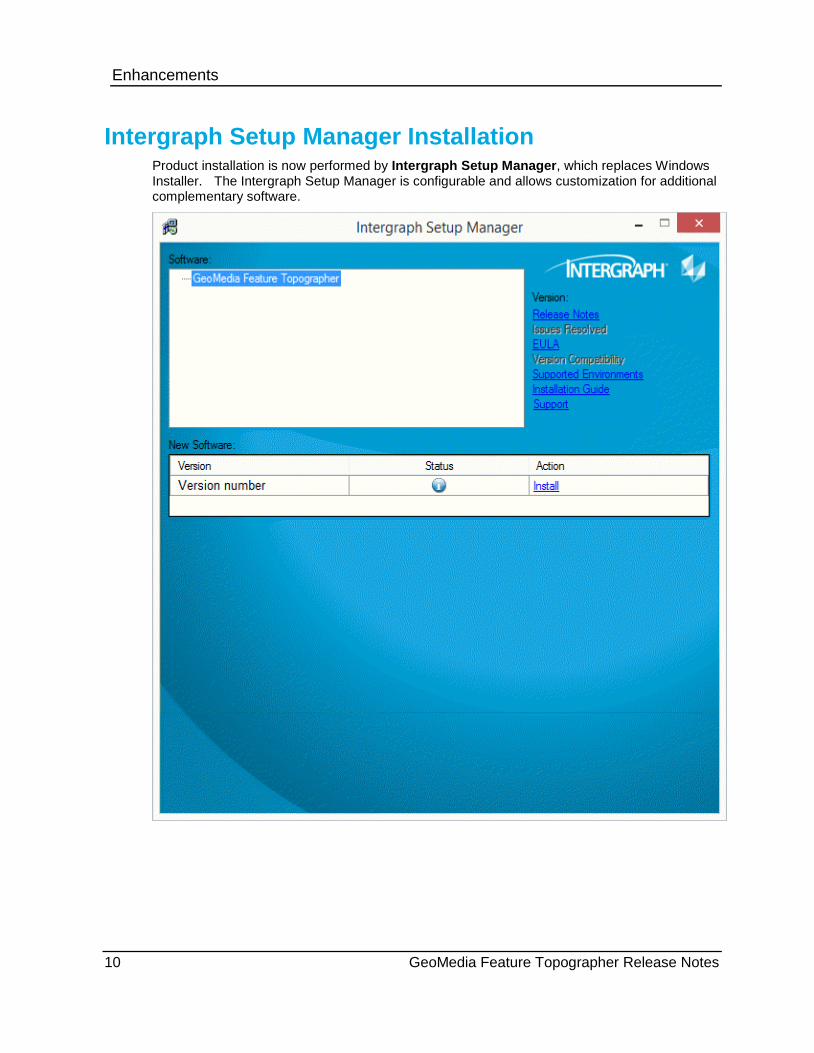
Intergraph Setup Manager Installation Product installation is now performed by Intergraph Setup Manager, which replaces Windows Installer. The Intergraph Setup Manager is configurable and allows customization for additional complementary software.

Enhancements
GeoMedia Feature Topographer Release Notes 11
MGCP (v4.0) (CR 1-67EAYU) Updated the existing Feature Topographer MGCP Schema Rules Symbology file to be in compliance with the evolving MGCP specifications.
Toggle FCT Tab The start menu utilities to Enable FCT in SRS and Disable FCT in SRS have been replaced with the Toggle FCT Tab utility. Use this utility to show or hide the FCT tab in the SRS Manager utility delivered by the GeoMedia GI Toolkit product. By default the FCT tab is turned off in the SRS Manager.
By selecting the Show FCT tabbutton, the FCT functionality will be enabled within the SRS Manager.
When the SRS Manager has been opened, you will see a tab labeled FCT.
By selecting the Hide FCT tabbutton, the FCT functionality will be disabled within the SRS. The FCT tab will no longer be displayed in the SRS Manager.

Enhancements
12 GeoMedia Feature Topographer Release Notes
Reset Documentation (GI-2978) This utility clears the registry entry value which specifies the path to the MGCP Specification files. The path is set the first time you invoke the Documentation tool icon on the GeoMedia Feature Topographer toolbar.
Once you have set the path to the documentation, it will remain until you invoke the Reset Documentation utility from the Start Menu.
Resize Toolbar fields (CR 1-7XQB1K) The Feature Topographer toolbar has been enhanced to allow you to resize the first three panels independently. By resizing each of the panels, you will be able to see the full string of text for each of the selected entries. When you hover over the fields on the toolbar, a tooltip will display the label of each field. For example, when hovering over the first field, the Categories tooltip will display.
Deletions
GeoMedia Feature Topographer Release Notes 13
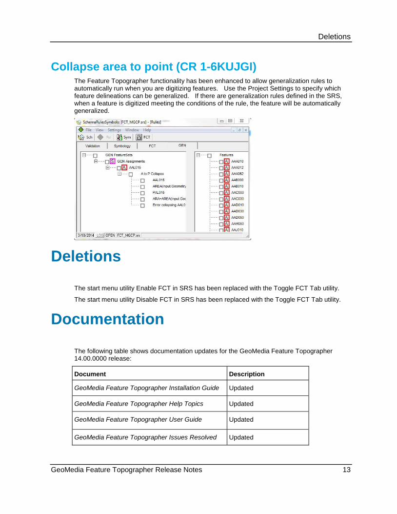
Collapse area to point (CR 1-6KUJGI) The Feature Topographer functionality has been enhanced to allow generalization rules to automatically run when you are digitizing features. Use the Project Settings to specify which feature delineations can be generalized. If there are generalization rules defined in the SRS, when a feature is digitized meeting the conditions of the rule, the feature will be automatically generalized.
The start menu utility Enable FCT in SRS has been replaced with the Toggle FCT Tab utility.
The start menu utility Disable FCT in SRS has been replaced with the Toggle FCT Tab utility.
The following table shows documentation updates for the GeoMedia Feature Topographer 14.00.0000 release:
Document Description
GeoMedia Feature Topographer Installation Guide Updated
GeoMedia Feature Topographer Help Topics Updated
GeoMedia Feature Topographer User Guide Updated
GeoMedia Feature Topographer Issues Resolved Updated
Deletions
Documentation
Hardware Requirements
14 GeoMedia Feature Topographer Release Notes
GeoMedia Feature Topographer Release Notes Updated
GeoMedia Feature Topographer Supported Environments
Updated
2 GHz microprocessor
4 GB RAM - recommended
1 GB disk space for installing software
SVGA display required (single monitor recommended), 1026 x 786 resolution and 32-bit color recommended.
Windows-compatible mouse or compatible digitizer for input
Access to CD-ROM or DVD drive (optional)
Hardware Requirements


Additional information on Intergraph Support and Services is available on the Internet. Use a Web browser to connect to Intergraph Online (http://www.intergraph.com). For general Intergraph information, call 1-800-791-3357 (U.S. and Canada) or 001-256-730-2000 (international).