geology of the searchlight district clark county… · geology of the searchlight district ......
TRANSCRIPT
UNITED STATES DEPARTMENT OF THE INTERIOR Harold L. Ickes, Secretary
GEOLOGICAL SURVEY W. C. Mendenhall, Director
Bulletin 906-D
GEOLOGY OF THE SEARCHLIGHT DISTRICT
CLARK COUNTY, NEVADA
BY
EUGENE CALLAGHAN
Contributions to economic geology, 1938-39 (Pages 135-188)
UNITED STATES
GOVERNMENT PRINTING OFFICE
WASHINGTON : 1939
For gale by the Superintendent of Documents, Washington, D. C. ....... Price 40 cents

CONTENTS
Page Abstract...___-__-__..____-_----__------_--_--__-.:-----------__---- '135Introduction _______-_-_____---__________---_----___-----__----____ 136Location ___________-___-____-_________-_---__-_-_--_----_--_-_..-- 139Surface features.__________________________________________________ 139Climate and vegetation.________________--__-_--______----_-_.-_-- 140Geology..-.._______...-_-.___._---. ._._ _...._ 140
General features,________--__-__-____-..--_---_____---__-__-_-__ 140Rock types___________________________________________________ 142
Gneiss ___-____-___---_______-___---_-_-_-___-_-_-___--__- 142Older volcanic rocks-___-_-___-__--_-_---_-___-----_-______ 142Andesite porphyry____-_--_____-_-_-----____-_-----------_- 14&Quartz monzonite and associated dike rocks___________________ 144:Later volcanic rocks.------------------------------I------- 145
Structure..--------_--_-------_-_--_--------__-_--------_---_- 146Summary of geologic history.___________________________________ 147
Mineral deposits.__-____-__-_-___-____-__r___-_-__.________________ 149History and production_----__-_-------__----_.___---_-_-_____- 149Mineralogy and classification__________________________._________ 151Vein structure-_____--___--___________-__..-_______-_-_____-_---. 155Rock alteration _______________________________________________ 157Areal zones of the mineral deposits.___.-_-___-_______-_________. 158Outlook for the district...----____-__._-_-_-_-_______-_________. 159
Mines and prospects._______________________________________________ 161Principal mines in the main part of the district_______.____________ 161
Quartette.__ _----_----_____----___-__-___._____--________- 161Good Hope (Phoenix)____.__-__________________-___________ 164Duplex_________________________________________________ 165Cyrus Noble-______---________-.______-___________________. 172Searchlight Parallel..--__________________________________ 173Santa Fe__--_____-----___________-____-______-_._________ 174Southern Nevada (Spokane)________________________________ 174Searchlight M. & M_______________________________________ 176Blossom. _________________________________________________ 176Pompeii. _ ________________________________________________ 179J. E. T___________________________________________________ 180
Other mines and prospects in the main part of the district._________ 182Mines and prospects in the eastern part of the district.__-_-.______ 183
Boston.......-_.-----__-----_-__-__-___________.______ 183Virginian _________________________________________________ 184Chief of the Hills..-----.--.-......-..._-_..._____.______-- 184Big Casino______________________________________________ 185New Era___.__________.______________________________..____ 185
Index.._____________________________________________ 187in
ILLUSTRATIONS
Pagr-
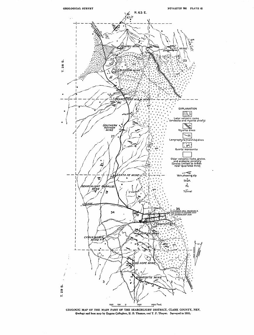
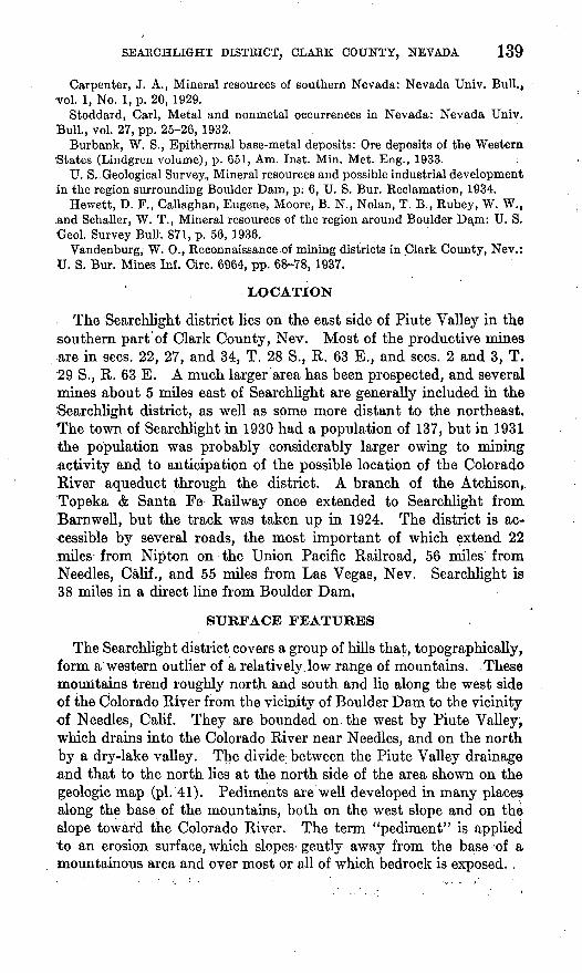
PLATE 41. Geologic map of the main part of the Searchlight District,Clark County, Nev____._-_-_-_-._.___.-_-.__________ 138
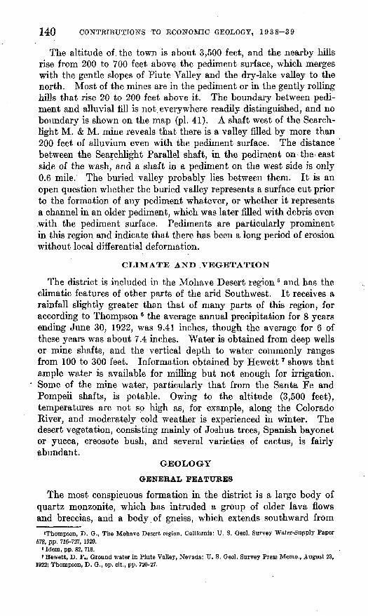
42. Block of pegmatitic facies of the gneiss partly enclosed in andesite porphyry from hill 1,000 feet southeast of the Quartette mine___-__i-_-----____-_-__--__-_-_-_---___- 142
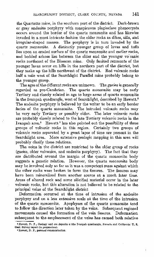
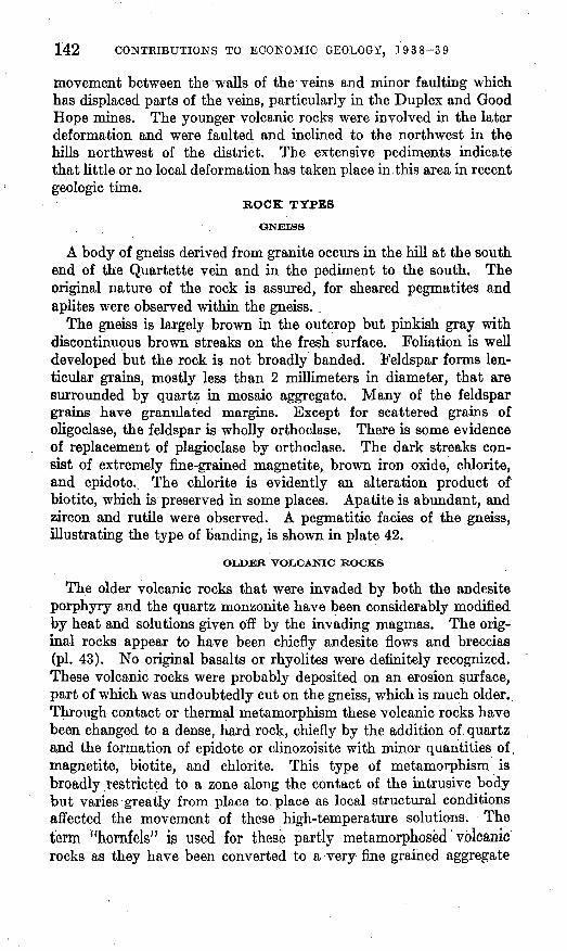
43. Hornfels from hill 1,000 feet south of Duplex mine___ ____ 14244. Vein material from Burdick stope on level 5 of Duplex mine,
below New Years Gift shaft.___-_.-______.__ _____ 14245. Plan and stope map of the Quartette mine, showing geology
in the new (1934) work on the 400-foot level and at the north end of the 100-foot level..-__-___ _------- _-_-. 162
46. Cross sections through Quartette mine, viewed from west toeast_____________ __-- --_. _--------.___ 162
47. Plan of workings of Good Hope mine___--____-___-________ 16648. Profile west-northwest through shaft of Good Hope mine____. 16649. Plan of workings of Duplex mine__------_-------_----____- 16650. Plan and longitudinal section of Searchlight M. & M. mine___ 17851. Areal geology in the vicinity of the Blossom mine.__________ 17852. Plan of principal underground workings of Blossom mine and
outline of surface ore body--_------_--_-----__----____- 17823. Map of parts of Nevada and Utah showing location of Search
light district and areas covered by previous publications of the United States Geological Survey and the Nevada State Bureau of Mines____.-__.__-___________.__.___.___-__.. 137
24. Longitudinal section of Duplex mine______________________ 16625. Section through Duplex mine showing relations of veins_____ 16826. Plan and section along shaft, Cyrus Noble mine__-__--_____ 17227. Plan and section through shaft, Searchlight Parallel mine
(Elvira? shaft).-____-------------------_____------... 17328. Plan of main level and section along shaft, Santa Fe mine... 17529. Section through Blossom mine.___------__--____-__.____. 17830. Plan and section along shaft of J. E. T. workings_______..__ 18131. Plan and section along shaft, Berlock workings__-_--.-___ 182
IV
GEOLOGY OF THE SEARCHLIGHT DISTRICT, CLARK COUNTY, NEVADA
By EUGENE CALLAGHAN
.ABSTRACT
The Searchlight district in Clark County near the southern tip of Nevada has produced from vein deposits gold, silver, copper, and lead valued at over $4,500,- 000. The shipping point on the Union Pacific Railroad is Nipton, 22 miles to the west, but the district is reached by roads from Las Vegas, Nev., and Needles, Calif.
The district, discovered in 1897, includes an outlying group of low hills on the east side of Piute Valley and on the west side of a low range of mountains that Slopes-more than 3,000 feet to the Colorado River. Gently sloping surfaces adjacent to the low hills are mainly pediments or slopes of bedrock with a thin mantle of alluvium. Many of the mines and prospects are in the pediments.
The oldest rock in the district is a granite gneiss exposed in the southern part of the district near the Quartette mine. It is overlain by a group of andesitic flows and breccias that have been largely converted to hornfels. These rocks were intruded in a most complex pattern by andesite porphyry, but both the andesite porphyry and the earlier rocks subsequently were intruded by a large body of quartz monzonite. The emplacement of the veins followed the invasion of the quartz monzonite. Extrusion of another series of volcanic rocks, exposed chiefly in the northwestern part of the district, followed a period of erosion. The ages of the different rocks are unknown, though the gneiss is judged to be pre-Cambrian, and the later rocks are considered to be early and late Tertiary. Warping and faulting followed the accumulation of the last group of volcanic rocks.
The veins are distributed in an en echelon pattern along the western arid southern -margins of the quartz monzonite body. Most of the veins have a westerly strike and dip moderately to the south. A few strike nearly north and dip to the west. The productive parts of the largest veins were about 1,000 feet long. Ore shoots were mined to a maximum depth of about 900 feet down the dip, but many veins were stoped only near the surface. The ore shoots consist of breccias of country rock cemented with vuggy quartz and, in the most productive veins, with the oxidation products of sulphide minerals. A peculiar ore shoot at the Blossom mine was saucer-shaped and nearly flat.
The principal product of all the mines was gold; silver was a minor product in terms of value except in a very few veins. Considerable quantities of copper came from the Quartette mine, and the Duplex mine yielded copper and lead in addition to gold and silver. With the exception of residual lumps of galena in the Duplex mine and some complex sulphide ore in the Big Casino mine, all the vein materials have been weathered. Original copper-bearing sulphides have changed to copper silicates, carbonates, and sulphates. Cerusite is the principal lead mineral, and hemimorphite (calamine) accounts for minor amounts of zinc. Gold is visible in
135
136 CONTRIBUTIONS TO ECONOMIC GEOLOGY, 1938-39
some of the rich ores, but no silver mineral was seen. Quartz is the dominant gangue mineral throughout the district, but adularia and calcite become promi nent in the northern part. Hematite is present in the Quartette vein.
The wall rock of the veins in the southern part of the district has been little modified by the vein-forming solutions, but in the northern part the wall rocks have been changed to an aggregate of quartz and adularia with remnants of earlier minerals. The regional variation in alteration of wall rocks together with a cor responding change in the ores indicates a zonal distribution of the deposits. The higher-temperature type of deposit is represented by the Quartette vein at the south, whereas the lower-temperature, outer zone type is represented by the Pompeii and J. E. T. mines to the north. This distribution is not radial with respect to the outcrop of the quartz monzonite.
Of the 16 mines and prospects described, the Quartette and the Duplex have had by far the largest production of gold and silver and also account for nearly the entire output of lead and copper. Explorations in the vicinity of some of the larger veins are expected to result in a continued small production from the district.
INTRODUCTION
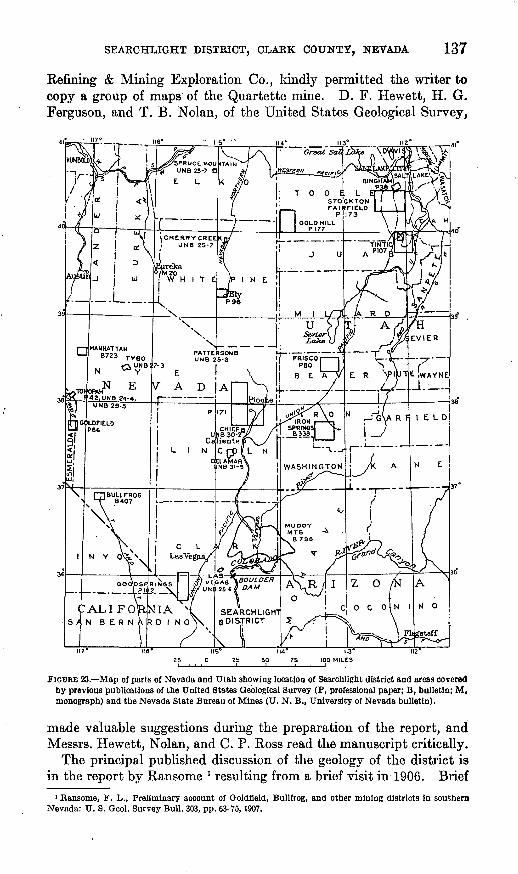
The Searchlight district, 35 miles from the southernmost tip of Nevada (fig. 23), has produced gold, silver, lead, and copper valued at more than $4,500,000. The district was most productive from 1903 to 1907, when the average value of the annual output was $447,650. Though production has greatly declined, the district has yielded some ore every year since its discovery. Two mines, the Quartette and the Duplex, account for the bulk of the production. The ore has been obtained from veins most of which strike N. 57°-70° W., dip 60° or less to the south, and are distributed along the contact of a large body of quartz monzonite, though only to a very slight extent within the intrusive body. The country rocks of the veins are chiefly intrustive andesite porphyry and a group of partly metamorphosed volcanic rocks or hornfels. Gneiss, judged to be pre-Cambrian, occurs in the southern part of the district. The veins are unique among those associated with lavas of presumable Tertiary age in Nevada in having produced a large proportion of base metals as well as a high ratio of gold to silver (about 1:1). Primary sulphide ore in minable quantities has been found in only one mine. The ore so far developed has not been found more than about 900 feet vertically below the surface.
The field work on which this report is based was carried on from November 4 to November 20, 1931, when the writer was assisted by H. E. Thomas, T. P. Thayer, and briefly by Mark Floto, and from December 5 to December 17, 1934, when L. B. Graff acted as assistant. Messrs. Thomas and Thayer obtained the greater part of the data for the geologic map (pi. 41). Residents of the district were uniformly helpful in supplying information, particularly Mr. A. S. Gaines, long a resident, and Mr. Dwight L. Sawyer, manager of the Quartette mine in 1934. Mr. R. T. Walker, then chief geologist of the U. S. Smelting,
137
Refining & Mining Exploration Co., kindly permitted the writer to copy a group of maps of the Quartette mine. D. F. Hewett, H. G. Ferguson, and T. B. Nolan, of the United States Geological Survey,
112*
FIGURE 23. Map of parts of Nevada and Utah showing location of Searchlight district and areas covered by previous publications of the United States Geological Survey (P, professional paper; B, bulletin; M, monograph) and the Nevada State Bureau of Mines (U. N. B., University of Nevada bulletin).
made valuable suggestions during the preparation of the report, andMessrs. Hewett, Nolan, and C. P. Ross read the manuscript critically.
The principal published discussion of the geology of the district isin the report by Ransome l resulting from a brief visit in 1906. Brief
1 Ransome, F. L., Preliminary account of Qoldfleld, Bullfrog, and other mining districts in southern Nevada: U. S. Geol. Survey Bull. 303, pp. 63-75,1907.
138 CONTRIBUTIONS TO; ECONOMIC. GEOLOGY, 19 3 8-^3 9
data on the district are given by Lincoln 2 and by Burbank.3 Vahden- burg 4 has briefly described mining and milling practice at several properties at or near Searchlight. The annual .volumes of Mineral Resources of the United States contain data on the mines as well as production figures.
A bibliography of articles that refer to the district is given below.Mineral Resources of the United States, U. S. Geol. Survey (1898-1923) and
U. S. Bur. Mines (1924 to date): 1898, pp. 579-580; 1903, p. 183; 1904, p. 146; 1905, pp. 116, 270; 1906, pp. 122, 296-297; 1907, pt. 1, pp. 368-369; 1908, pt. 1, pp. 473-474, pt. 2, p. 846; 1909, pt. 1, pp. 395-396; 1910, pt. 1, p. 508; 1911, pt. 1, p. 669; 1912, pt. 1, p. 786; 1913, pt. 1, p. 818; 1914, pt. 1, p. 672; 1915, pt. 1, p. 627; 1916, pt. 1, p. 471; 1917, pt. 1, p. 267; 1918, pt. !, p. 231; 1919, pt. 1, p. 387; 1920, pt. 1, p. 320; 1921, pt. 1, p. 380; 1922, pt. 1, p. 320; 1923, pt. 1, p. 494; 1924, pt. 1, p. 431; 1925, pt. 1, p. 676; 1926, pt. 1, p. 531; 1928, pt. 1, p. 455; 1929, pt. 1, p. 652; 1930, pt. 1, p. 531; 1931, pt. 1, p. 613.
Minerals Yearbook, U. S. Bur. Mines, 1932-33, p. 130; 1934, p. 213; Statistical Appendix, 1932-33, p. 248; 1934, p. 22.
Eng. and Min. Jour., vol. 67, p. 184, 1899; vol. 69, p. 660, 1900; vol. 70, p. 769, 1900; vol. 73, p. 396, 1902; vol. 75, p. 347, 1903; vol. 76, p. 483, 1903.
Duffield, M. S., The outlook for mining in the new territory opened up by the San Pedro, Los Angeles & Salt Lake Railroad: Eng. and Min. Jour., vol. 77, p. 202, 1904..
Searchlight district, Nevada: Min. and Sci. Press, vol. 90, p. 172, 1905.Ransome, F. L., Preliminary account of Goldfield, Bullfrog, and other mining
districts in southern Nevada: U. S. Geol. Survey Bull. 303, pp. 63-75, 1907.Stuart, E. E., Nevada's mineral resources, pp. 132-133, Carson City, 1909.Hill, J. M., The mining districts of the western United States: U. S. Geol.
Survey Bull. 507, p. 202, 1912.Cyanide plant at the Quartette mine, Nevada: Min. and Sci. Press, vol. 106,
p. 953, 1913.Horton, F. W., Molybdenum, its ores and their concentration: U. S. Bur.
Mines Bull. Ill, p. 89, 1916.Corn, G. B., The Searchlight review, 77 pp., Searchlight, Nev., 1917. !Schrader, F. G., Stone, R. W., and Sanford, Samuel, Useful minerals of the
United States: U. S. Geol. Survey Bull. 624, p. 194, 1917.Hewett, D. F., Ground water in Piute Valley, Nevada: U. S. Geol. Survey,
Press Memo., August 23, 1922.Lincoln, F. C., Mining districts and mineral resources of Nevada, pp. 24-27,
Reno, Nevada Newsletter Publishing Co., 1923.Weed, W. H., The Mines Handbook; vol. 15, pp. 1145, 1187, 1302, 1325, 1345,
Tuckahoe, N. Y., 1922; vol. 26, pp. 1328-1329,1478,1479,1925; vol. 27, pp. 1165, 1296, 1297, 1926.
Thompson, D. G., The Mohave Desert region, California: U. S. Geol. Survey Water-Supply Paper 578, pp. 716-727, 1929.
Ferguson, H. G., The mining districts of Nevada: Econ. Geology, vol. 24, p. 135, 1929.
»Lincoln, P. 0., Mining districts and mineral resources of Nevada, pp. 24-27, Reno, Nevada Newsletter Publishing Co., 1923. .
« Burbank, W. S., Epithermal base-metal deposits: Ore deposits of the Western States (Lindgren volume), p, 651, Am. Inst. Min. Met. Eng., 1933.
«Vandenburg, W. 0., Reconnaissance of mining districts in Clark County, N6V,,1 BUT, Mines Inf., Circ, 6964, pp. 68-78,1937.
GEOLOGICAL SURVEY
H
BULLETIN 906 PLATE 41
vV R.63E.
Later volcanic rocks (andesite and rhyolite chiefly)
.--/' X^X" \"
'w/ncrtn ». ?i'NEVADA Yl : .. ** t A/C ^L^fft^ « i
>v - -- -- --
'LIGHT mtALLEL Y ; WNE /" \ / .
ff^^tl 0 !. "«** ' * t'-. » TD KINGMANAKl. JETyy^^g, ,,,1^1^* -1; * ^^MMMMM^^rx*/T MIHfSIMf.V7E« rl^T! r ' -'11" ^\ " ^.o** seA*CH<-'<*>
Lamprophyre (malchite) dikes
11 flm-> 1
Quartz monzonite
Older volcanic rocks, gneiss,and andesite porphyry
(Gneiss limited to areas near Quartette mine)
N iv .** r .^ *» 'v H / »' - i M'11 i. \ -^* ^ ." X ^^.':-l ' > V^o r " r j *
^ V %^;'-^^r -^- yrl ̂ ^V^'^ v* .^<*% -' ^ I
\ /-, s"^.1--^"v -. ' ^F'/-*"%; A / - c j ; A* !«4 ./» J-- /*** ^! \ / '"xJ*\S^Tl ^-^ >' ' * j/ "* £
':? »« _ /^-. _-/- "^-'J:*/ i I / V *s~l"Ml r3 "1 . i * " */*. *" i ll ' 5
)00 ^ 500 O
X X
1000 2000 Feet
GEOLOGIC MAP OF THE MAIN PART OF THE SEARCHLIGHT DISTRICT, CLARK COUNTY, NEV. Geology and base map by Eugene Callaghan, H. E. Thomas, and T. P. Thayer. Surveyed in 1931.
SEARCHLIGHT DISTRICT, CLARK COUNTY, NEVADA 139
Carpenter, J. A., Mineral resources of southern Nevada: Nevada Univ. Bull., vol. 1, No. 1, p. 20, 1929.
Stoddard, Carl, Metal and nonmetal occurrences in Nevada: Nevada Univ. Bull., vol. 27, pp. 25-26, 1932.
Burbank, W. S., Epithermal base-metal deposits: Ore deposits of the Western States (Lindgren volume), p. 651, Am. Inst. Min. Met. Eng., 1933. :
U. S. Geological Survey., Mineral resources and possible industrial developmentin the region surrounding Boulder Dam, p. 6, U. S. Bur. Reclamation, 1934.
Hewett, D. F., Callaghan, Eugene, Moore, B. N., Nolan, T. B., Rubey, W. W.,.and Schaller, W. T., Mineral resources of the region around Boulder Dam: U. S. Geol. Survey Bull. 871, p. 56, 1936.
Vandenburg, W. 0., Reconnaissance-of mining districts in Clark County, Nev.: U. S. Bur. Mines Inf. Circ. 6964, pp. 68-78, 1937.
LOCATION
The Searchlight district lies on the east side of Piute Valley in the southern part of Clark County, Nev. Most of the productive mines are in sees. 22, 27, and 34, T. 28 S., R. 63 E., and sees. 2 and 3, T. 29 S., R. 63 E. A much larger area has been prospected, and several mines about 5 miles east of Searchlight are generally included in the 'Searchlight district, as well as some more distant to the northeast. The town of Searchlight in 1930 had a population of 137, but in 1931 the population was probably considerably larger owing to mining activity and to anticipation of the possible location of the Colorado River aqueduct through the district. A branch of the Atchison,. Topeka & Santa Fe Railway once extended to Searchlight from Barnwell, but the track was taken up in 1924. The district is ac cessible by several roads, the most important of which extend 22 miles from Nipton on the Union Pacific Railroad, 56 miles from Needles, Calif., and 55 miles from Las Vegas, Nev. Searchlight is 38 miles in a direct line from Boulder Dam.
SURFACE FEATURES
The Searchlight district covers a group of hills that, topographically, form a western outlier of a relatively, low range of mountains. These mountains trend roughly north and south and lie along the west side of the Colorado River from the vicinity of Boulder Dam to the vicinity of Needles, Calif. They are bounded on the west by Piute Valley, which drains into the Colorado River near Needles, and on the north by a dry-lake valley. The divide, between the Piute Valley drainage and that to the north lies at the north side of the area shown on the geologic map (pi. 41). Pediments are well developed in many places along the base of the mountains, both on the west slope and on the slope toward the Colorado River. The term "pediment" is applied to an erosion surface, which slopes gently away from the base of a mountainous area and over most or all of which bedrock is exposed. ,
140 CONTRIBUTIONS TO ECONOMIC GEOLOGY, 1938-39
The altitude of the town is about 3,500 feet, and the nearby hills rise from 200 to 700 feet above the pediment surface, which merges with the gentle slopes of Piute Valley and the dry-lake valley to the north. Most of the mines are in the pediment or in the gently rolling hills that rise 20 to 200 feet above it. The boundary between pedi ment and alluvial fill is not everywhere readily distinguished, and no boundary is shown on the map (pi. 41). A shaft west of the Search light M. & M. mine reveals that there is a valley filled by more than 200 feet of alluvium even with the pediment surface. The distance between the Searchlight Parallel shaft, in the pediment on > the east side of the wash, and a shaft in a pediment on the west side is only 0.6 mile. The buried valley probably lies between them. It is an open question whether the buried valley represents a surface cut prior to the formation of any pediment whatever, or whether it represents a channel in an older pediment, which was later filled with debris even with the pediment surface. Pediments are particularly prominent in this region and indicate that there has been a long period of erosion without local differential deformation.
CLIMATE AND VEGETATION
The district is included hi the Mohave Desert region 6 and has the climatic features of other parts of the arid Southwest. It receives a rainfall slightly greater than that of many parts of this region, for according to Thompson 6 the average annual precipitation for 8 years ending June 30, 1922, was 9.41 inches, though the average for 6 of these years was about 7.4 inches. Water is obtained from deep wells or mine shafts, and the vertical depth to water commonly ranges from 100 to 300 feet. Information obtained by Hewett 7 shows that ample water is available for milling but not enough for irrigation. Some of the mine water, particularly that from the Santa Fe and Pompeii shafts, is potable. Owing to the altitude (3,500 feet), temperatures are not so high as, for example, along the Colorado River, and moderately cold weather is experienced in winter. The desert vegetation, consisting mainly of Joshua trees, Spanish bayonet or yucca, creosote bush, and several varieties of cactus, is fairly abundant.
GEOLOGY
GENERAL FEATURES
The most conspicuous formation in the district is a large body of quartz monzonite, which has intruded a group of older lava flows and breccias, and a body.of gneiss, which extends southward from
'Thompson, D. G., The Mohave Desert region, California: U. S. Geol. Survey Water-Supply Paper 578, pp. 7J6-727, 1929.
Idem, pp. 82, 718.'Hewett, D. F., Ground water in Piute Valley, Nevada: U. S. Geol. Survey Press Memo., August 23,
1922; Thompson, D. G., op. cit., pp. 720-27.
SEARCHLIGHT DISTRICT, CLARK COUNTY, NEVADA 141
the Quartette mine, in the southern part of the district. Dark-brown or gray andesite porphyry with conspicuous plagioclase phenocrysts occurs around the border of the quartz monzonite and has likewise invaded in a most intricate fashion the older rocks as dikes, sills, and irregular-shaped masses. The porphyry is in turn invaded by the quartz monzonite. A distinctly younger group of lavas and tuft's lies upon an eroded surface of the quartz monzonite and earlier rocks, and bedded arkose lies between the older and the younger volcanic rocks northeast of the Blossom mine. Only faulted remnants of the younger lavas occur on hills in the northern part of the district, but they make up the hills northwest of the district. Red volcanic rocks half a mile west of the Searchlight Parallel mine probably belong to the younger group.
The ages of the different rocks are unknown. The gneiss is generally regarded as pre-Cambrian. The quartz monzonite may be early Tertiary and closely related in age to large areas of quartz monzonite in the Ivanpah quadrangle, west of Searchlight, described by Hewett. 8 The andesite porphyry is believed by the writer to be an early border facies of the quartz monzonite. The intruded volcanic rocks may be very early Tertiary or possibly older. The later volcanic rocks are probably closely related to the late Tertiary volcanic rocks in the Ivanpah area.8 Hewett 9 has also pointed out the possibility of three groups of volcanic rocks in this region. Certainly two groups of volcanic rocks separated by a great lapse of time are present in the Searchlight area. More extensive geologic mapping in this area will probably clarify these relations.
The veins in the district are restricted to the older group of rocks (gneiss, older volcanics, and andesite porphyry). The fact that they are distributed around the margin of the quartz monzonite body suggests a genetic relation. However, the quartz monzonite body may be involved only so far as it was a competent mass against which the other rocks were broken to form the fissures. The fissures may have been mineralized from another source at a much later time. Areas of altered rock and some silicified material occur in the later volcanic rocks, but this alteration is not believed to be related to the principal veins of the Searchlight district
Deformation occurred at the time of intrusion of the andesite porphyry and on a less extensive scale at the time of the intrusion of the quartz monzonite. Apophyses of the quartz monzonite tend to follow the direction later taken by the veins. Subsequent regional movements caused the formation of the vein fissures. Deformation subsequent to the emplacement of the veins has caused both relative
B Hewett. D. F., Geology and ore deposits o (the Ivanpah quadrangle, Nevada and California: U. 8. Oeol. Survey report (in preparation).
Hewett, D. P., personal communication.
142 CONTRIBUTIONS TO ECONOMIC GEOLOGY, 1938-39
movement between the walls of the veins and minor faulting which has displaced parts of the veins, particularly in the Duplex and Good Hope mines. The younger volcanic rocks were involved in the later deformation and were faulted and inclined to the northwest in the hills northwest of the district. The extensive pediments indicate that little or no local deformation has taken place in.this area in recent geologic time.
BOCK TYPES
GNEISS
A body of gneiss derived from granite occurs hi the hill at the south end of the Quartette vein and in the pediment to the south. The original nature of the rock is assured, for sheared pegmatites and aplites were observed within the gneiss. ,
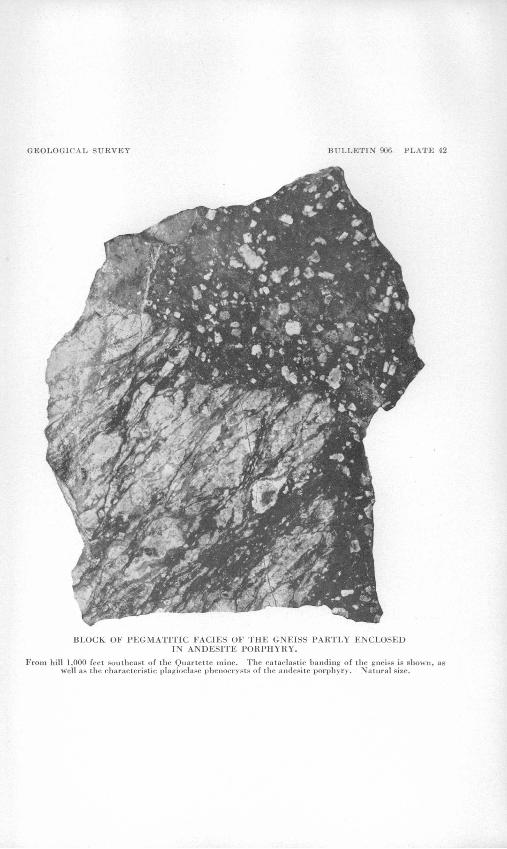
The gneiss is largely brown in the outcrop but pinkish gray with discontinuous brown streaks on the fresh surface. Foliation is well developed but the rock is not broadly banded. Feldspar forms len ticular grains, mostly less than 2 millimeters in diameter, that are surrounded by quartz in mosaic aggregate. Many of the feldspar grains have granulated margins. Except for scattered grains of oligoclase, the feldspar is wholly orthoclase. There is some evidence of replacement of plagioclase by orthoclase. The dark streaks con sist of extremely fine-grained magnetite, brown iron oxide, chlorite, and epidote. The chlorite is evidently an alteration product of biotite, which is preserved in some places. Apatite is abundant, and zircon and rutile were observed. A pegmatitic facies of the gneiss, illustrating the type of banding, is shown hi plate 42.
OLDER VOL.CAJSIC ROCKS
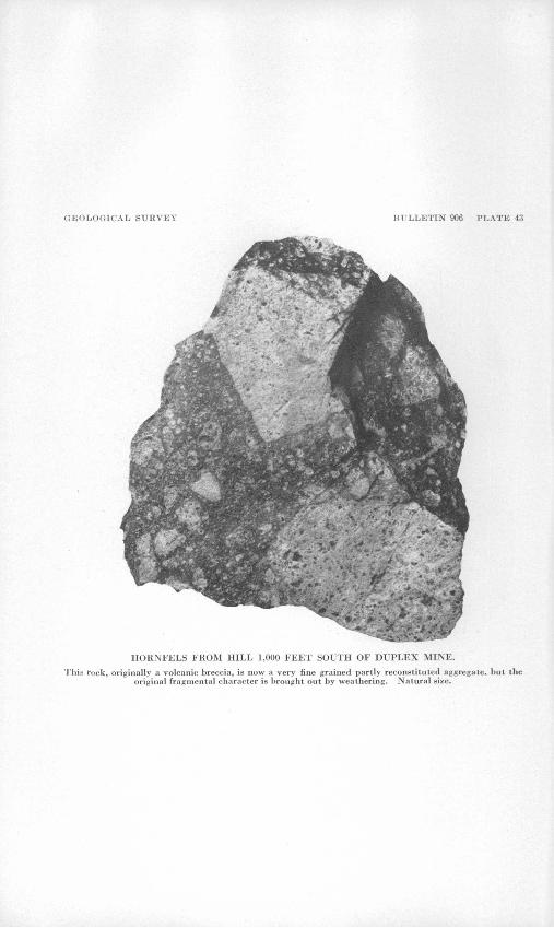
The older volcanic rocks that were invaded by both the andesite porphyry and the quartz monzonite have been considerably modified by heat and solutions given off by the invading magmas. The orig inal rocks appear to have been chiefly andesite flows and breccias (pi. 43). No original basalts or rhyolites were definitely recognized. These volcanic rocks were probably deposited on an erosion surface, part of which was undoubtedly cut on the gneiss, which is much older.. Through contact or thermal metamorphism these volcanic rocks have been changed to a dense, hard rock, chiefly by the addition of quartz and the formation of epidote or clinozoisite with minor quantities of b magnetite, biotite, and chlorite. This type of metamorphism is broadly restricted to a zone along the contact of the intrusive body but varies greatly from place to place as local structural conditions affected the movement of these high-temperature solutions. The term "hornfels" is used for these partly metamorphosed volcanic rocks as they have been converted to a very fine grained aggregate
GEOLOGICAL SURVEY BULLETIN 906 PLATE 42
BLOCK OF PEGMATITIC FACIES OF THE GNEISS PARTLY ENCLOSED IN ANDESITE PORPHYRY.
From hill 1,000 feet southeast of the Quartette mine. The eataclastic Lauding of the gneiss is shown, as well as the characteristic plagioclaHe phenocrysts of the andesite porphyry. Natural size.
GEOLOGICAL SURVEY BULLETIN 906 PLATE 43
HORNFELS FROM HILL 1,000 FEET SOUTH OF DUPLEX .
This rock, originally a volcanic breccia, is now a very fine grained partly reconstituted aggregate, but the original fragmental character is brouglit out by weathering. Natural size.
GEOLOGICAL SURVEY BULLETIN 906 PLATE 44
VEIN MATERIAL FROM BURDICK STOPE ON LEVEL 5 OF DUPLEX MINE, BELOW NEW YEARS GIFT SHAFT.
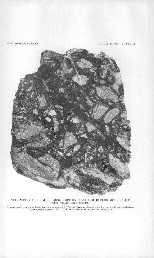
A breccia of greenish anJesite hornfels cemented by "comb" quartz stained dark by iron oxide and containing some green copper stain. Gold occurs in minute spots in the quartz.
SEARCHLIGHT DISTRICT, CLARK COUNTY, NEVADA 143
in which the original texture and structure are largely obliterated and new minerals formed. 10
These hornfelses are mostly dark greenish gray and very fine-grained. Differential weathering of exposed surfaces reveals flow structure and phenocrysts in the lavas and the fragments in the breccias (pi. 44). No definite evidence of shearing of these flows was found. Plagioclase phenocrysts, chiefly andesine, are moderately well preserved, but all original ferromagnesian minerals have been destroyed. In some places plagioclase phenocrysts are sufficiently abundant and large to cause confusion with some facies of the andesite porphyry. The groundmass is largely recrystallized and consists chiefly of remnants of feldspar, quartz, and epidote or clinozoisite. Magnetite is scat tered through much of the hornfels and also occurs in bunches. The epidote or clinozoisite scattered through the rock is only slightly if at all colored in thin section, although that in later veinlets and associated with quartz and calcite is more highly colored or more ferriferous. Hornfels from a shaft south of the Blossom mine contains disseminated pyrite. In the walls of the larger veins, particularly in those of the Duplex mine, there has been little alteration of the hornfels, and vein minerals lie against recognizable feldspar grains. Weathering along the veins has caused some of the hornfels to become soft and clayey.
ANDESITE PORPHYKY
Andesite porphyry is the wall rock of many of the veins. This asso ciation has led to the belief among the miners and prospectors that ore occurs only with the porphyry or that there is a genetic relationship. It is very abundant around the margin of the quartz monzonite body, and scarcely any large fracture could have formed without being in part in the andesite porphyry. The porphyry has penetrated the gneiss and the older volcanic rocks in a most complex fashion as dikes, sills, and masses having very irregular margins. The intrusive rela tions give the impression of a huge breccia of older rocks with some blocks hundreds of feet long cemented by andesite porphyry. Both the andesite porphyry and the older rocks are penetrated by dikes of quartz monzonite, as shown on the map (pi. 41), but not to. the extent to which the porphyry has penetrated its antecedents. It is suggested that the andesite porphyry is an early facies of the quartz monzonite intrusive bodies, and that there was only a relatively slight lapse of tune between the intrusions of the two. The porphyry has been somewhat modified by the quartz monzonite intrusion and by the vein-forming solutions.
The andesite porphyry is mostly brownish on weathered surfaces, with conspicuous phenocrysts of white plagioclase, chiefly oligoclase,
10 Buddington, A. F., and Callaghan, Eugene, Dioritic Intrusive rocks and contact metamorphlsm In the Cascade Kange of Oregon: Am. Jour. Sci., 5th ser., vol. 31, No. 186, p. 443, 1936.
144 CONTRIBUTIONS TO ECONOMIC GEOLOGY, 1938-39
as shown in plate 42. In some places, particularly in the vicinity of veins underground, it is gray, but near the Chief of the Hills mine, east of Searchlight, it has a purplish cast. There is also a wide varia tion in size and abundance of the plagioclase phenocrysts, which range from a fraction of a millimeter to more than an inch in length. Porphyry with only small phenocrysts is difficult to distinguish in the field from porphyritic andesite of the older volcanic rocks, on the one hand, and from very porphyritic facies of the quartz monzonite, or even from some of the porphyritic andesites in the younger volcanic rocks, on the other hand. Flakes of biotite remain as phenocrysts in much of the porphyry, as well as pseudomorphs after hornblende. The hornblende appears to have been resorbed during the cooling of the magma, rather than destroyed during later alteration. Its place is taken by a granular aggregate made up in part of magnetite and epidote, though in many specimens the form of the original horn blende is well preserved. Some of the pseudomorphs are 5 millimeters or more in length, but most are between 0.5 and 1 millimeter. The groundmass is a very fine grained aggregate composed largely of plagioclase grains.
Evidence of the initial alteration involving the resorption of horn blende was observed in all specimens. Epidote is associated with quartz in nodules in the porphyry. A good exposure at the Chief of the Hills mine shows a broad band of epidotized porphyry near the vein, indicating that at least part of the epidpte.-forming solutions arose along the vein fractures, apparently prior to the deposition of the vein minerals. Some of the porphyry near the veins is changed to a soft aggregate consisting largely of clay minerals. Porphyry associ ated with some of the veins in the northern part of the district, particu larly the Pompeii, is largely changed to adularia.
It is suggested that the andesite porphyry represents the first inva sion of the magma into a relatively thin cover of volcanic flows and breccias that broke and separated readily because of a relatively light superincumbent load. Probably the porphyry magma broke through to the surface and accumulated as flows to such a depth that the next pulse of the magma had sufficient cover to cool as quartz monzonite.
QUARTZ MONZONITE AND ASSOCIATED DIKE ROCKS
The quartz monzonite body underlies a large area east of the main part of the district and north of the mines east of the town. It is part of a large body or group of bodies that are known to occur in this region but have not been mapped. The contact is very irregular, as shown by plate 41. Many dikes and sill-like protuberances project into the invaded rocks. Only the margins of the body and dikes extending out ward from it were studied, as the veins are either wholly outside the quartz monzonite or extend only a short distance into it.
SEARCHLIGHT DISTRICT, CLARK COUNTY, NEVADA .145
The marginal facies of the quartz monzonite is mostly porphyritic, and both the size and the relative proportions of phenocrysts as well as the proportions of dark minerals and color are variable. The rock consists of plagioclase (oligoclase and andesine), orthoclase, quartz, biotite, augite, magnetite, apatite, and zircon. In hand specimens the orthoclase is light gray, and much of the plagioclase is dark purplish gray. Quartz is either interstitial to the feldspars or in graphic inter- growths with orthoclase. Biotite is the most prominent ferromagne- sian mineral, but augite is moderately abundant. Magnetite grains are widely variable in size. A slight amount of orthoclasization of plagioclase has taken place. Some biotite has become green, and more augite is partly altered to chlorite. Some areas of chlorite give no definite clue to the original mineral, which may have been hypersthene.
Approximately equal proportions of orthoclase and plagioclase led Ransome n to classify the rock as a quartz monzonite, though the dioritic aspect imparted by the augite should be noted. No horn blende was seen in any of the thin sections of the marginal facies.
Dikes of granophyre, which consists largely of graphic intergrowths of quartz and orthoclase, were observed; also dikes of lamprophyre or malchite, and light-gray rhyolite. The rhyolite dikes are especially prominent in the northern part of the district. The malchite consists largely of a groundmass of minute altered feldspars and sporadic plagioclase phenocrysts and pseudomorphs of chlorite and carbonate after a former ferromagnesian mineral. Chlorite, carbonate, and epidote now make up a large portion of the rock. The rhyolite con sists of scattered phenocrysts of quartz, oligoclase, and chlorite pseudo morphs after biotite in an extremely fine-grained devitrified ground- mass. Sericite is abundant as an alteration product. The rhyolite dikes are probably related to the later volcanic rocks. A group of biotite andesite dikes that traversed the andesite porphyry was noted by Jaggar and Palache 12 in the Quartette mine. Their age relation to the veins is not known. Locally they were called neoandesite.
I.ATER VOLCANIC ROCKS
A group of volcanic rocks, consisting of both fragmental or pyro- clastic rocks and flows, constitutes the youngest group in the small area studied. These later volcanic rocks are exposed on hills in the north ern part of the district, in the more prominent hills to the west of the northern part of the district, in the pediment west of the district, in a hill south of the Quartette mine, and in a wedge-shaped area west of the Chief of the Hills mine. In a gully northeast of the Blossom mine a small lens of arkose lies between exposures of the later volcanic rocks
11 Ransome, F. L., Preliminary account of Goldfleld, Bullfrog, and other mining districts in southern Nevada: U. S. Qeol. Survey Bull. 303, p. 66,1907.
»' Jaggar, T. A., Jr., and Palache, Charles, private report on Quartette mine. 1911.
146 CONTRIBUTIONS TO ECONOMIC GEOLOGY, 1938-39
and the quartz monzonite and associated early, partly metamorphosed volcanic rocks.
The flows of the later volcanic rocks range from basalt to rhyolite, though flows of basalt are distinctly in the minority. A flow of olivine basalt, inclined toward the northwest, forms a prominent ridge north west of the north end of the district and about 2 miles from the Pompeii mine. The basalt consists of phenocrysts of labradorite, olivine, augite, and magnetite in a very fine-grained groundmass of minute plagioclase laths and grains of ferromagnesian minerals.
Biotite andesite on a hill northwest of the Blossom mine is a light- gray rock with numerous large phenocrysts of plagioclase and smaller phenocrysts of biotite and hornblende. A reddish andesite with pro nounced flow structure on a low ridge farther to the northwest contains phenocrysts of plagioclase and biotite, "ghosts" of hornblende crystals, and remants of a few augite crystals largely altered to carbonate in a groundmass.consisting of minute plagioclase laths and extremely small grains of other minerals. Near the road west of the Blossom mine a rhyolite at the contact of the younger volcanics with the older rocks contains numerous quartz grains of various sizes, plagioclase pheno crysts, and smaller phenocrysts of biotite, magnetite, and titanite in a devitrified groundmass containing quartz grains and extremely minute feldspars. An andesite at the contact east of the road northwest of the Pompeii mine contains phenocrysts of biotite, hornblende, augite, plagioclase, and magnetite in a very fine-grained groundmass. Frag ments of pitchstone were found in tuff near the flow of olivine basalt northwest of the Pompeii mine.
In general, the younger volcanic rocks are more rhyolitic and latitic than the flows intruded by the quartz monzonite, and they contain flows of olivine basalt.
STRUCTURE
The area studied is so small that little can be said of the regional structural setting. Bedding planes in the older volcanic rocks were largely destroyed during metamorphism and intrusion. Jaggar and Palache 13 state in this connection that the flows at the Quartette mine lie on the gneiss and dip 40° N. Original structure in both the gneiss and the older volcanic rocks is much disturbed by the seem ingly heterogeneously oriented dikes, sills, and masses of andesite porphyry. At one place on the 400 level of the Quartette mine the foliation of the gneiss strikes N.. 34° W. and dips 15° NE. The quartz monzonite forms an almost rectangular body within the district, with one corner lying under cover east of the Quartette mine and another corner well exposed in the northern part of the district. Apophyses of the quartz monzonite tend to follow the west-northwest
««Jaggar, T. A., Jr., and Palache, Charles, .private report on Quartette mine, 1911.
SEARCHLIGHT DISTRICT,, CLARK COUNTY, NEVADA 147
trend later taken by the veins, and at the south end of level 2 from the Searchlight shaft of the Duplex mine a dike of quartz monzonite lies parallel to the vein fracture. The quartz monzonite seems to have resisted rupture, and as a consequence, so far as could be ascer tained, the older rocks molded to it are not greatly faulted. During regional movements that followed the consolidation of the quartz monzonite, that body appears to have acted as a competent mass, so that fractures were formed in regular pattern around its margin in the less competent older volcanic rocks and andesite porphyry.
Most of the fractures subsequently mineralized to a varying degree have a west-northwest trend, but there is a much less prominent and less extensively mineralized system nearly at right angles. Both sets of fractures are believed to be of the gash type, with maximum move ment in the center and the amount of displacement decreasing both toward the ends and in depth. This seems to account for the restric tion of the ore bodies. Movements subsequent to the deposition of the ores caused relative displacement between the walls of the veins, brecciating the vein material and forming gouge seams through both the vein material and the country rock. These movements also caused minor displacements of the veins along normal faults striking slightly east of north and dipping mostly to the east.
The later volcanic rocks are greatly disturbed. Those northwest of the north end of the district are inclined to the northwest as much as 55° and appear to be extensively faulted. Ransome 14 shows a wedge of volcanic rocks inclined toward the west between the town and the mines in the eastern part of the district.
In general, it appears that the quartz monzonite and the older rocks immediately associated with it constitute an uplifted mass that has resisted deformation. Regional stresses acting against the .quartz monzonite body produced the fractures around that body that were later mineralized. Later uplifts caused faulting in the mineralized area and faulting and tilting of the later volcanics away from the older rocks.
SUMMARY OF GEOLOGIC HISTORY
From such information as is available in this small area the fol lowing sequence of geologic events is deduced. The pre-Cambrian (?) gneiss was denuded of the great thickness of Paleozoic and Mesozoic rocks exposed to the west 15 and north. 16 On this floor of the pre- Cambrian (?) rocks, which was probably very uneven, there was
" Eansome, F. L., op. cit., p. 67.14 Hewett, D. F., Geology and ore deposits of the Goodsprings quadrangle, Nevada: XI. S. Geol. Survey
Prof. Paper 162, pp. 9-36,1931; Geology and ore deposits of the Ivanpah quadrangle, Nevada and California: U. S. Geol. Survey report (in prepartion).... "> Longwell, 0. R., Geology of the Muddy Mountains, Nevada: U. S. Geol. Survey Bull. 798, pp. 20- 68, 1928.
136973 39 2
148 CONTRIBUTIONS TO ECONOMIC GEOLOGY, 1938-39
extruded a series of andesitic lava flows and tuffs or volcanic brecciasj>
of unknown thickness. These rocks were intruded by a magma that invaded both the gneiss and the volcanic rocks in a most intricate pattern. The first intrusions consolidated as andesite porphyry, but at a later stage a part of the magma invaded the porphyry as well as the older rocks and solidified as quartz monzonite. It is suggested that both the texture of the andesite porphyry and the pattern of the intrusive masses indicate that the magma first broke into a thin cover of volcanic rocks. It may even have reached the surface and spread out as flows, affording the later magma sufficient cover to crystallize as quartz monzonite. The early lavas were changed to hornfels by heat and solutions from the intrusive rocks. The andesite porphyry was also somewhat modified as a consequence of the intrusion of the quartz monzonite.
Regional movements acting against the competent buttress afforded by the quartz monzonite body produced the fractures that were later mineralized. The mineralization may have been closely related to the quartz monzonite in that the solutions came from very deep within that body after the magma near the surface had consolidated. How ever, the mineralization may have been related to a later igneous epoch, its relation to the quartz monzonite being determined only by the previously available fracture system.
The area was uplifted and deeply eroded, probably with accompa nying movements on the veins and brecciation of the ores. Possibly the oxidation of the veins took place at this time, when the relief was great, providing for circulation of ground water and accounting for the lack of coincidence between oxidation and present ground- water level. Another series of lavas and fragmental rocks was laid down on the erosion surface, and dikes of rhyolite and possibly of andesite penetrated the older rocks, including the quartz monzonite. Large masses of the volcanic rocks were altered by hydro thermal solu tions. Further uplift of the central area tilted the later volcanic rocks to the west on the west side of the area. Faulting, both along and across the veins, probably accompanied this later uplift but may have taken place at an earlier time. Erosion progressed, Piute Valley was partly filled, and pediments were developed.
As no fossiliferous rocks occur in this area and no other methods of dating have been tried, it is not possible to fit these events into the geologic timetable exactly. As volcanic rocks in this region are generally believed to be of Tertiary age, all the rocks later than the gneiss are probably Tertiary. Granitoid intrusive rocks in the area to the west 17 are probably of early Tertiary age and earlier than the ores, whereas the younger volcanic rocks are much later than the
" Hewett, D. P., Geology and ore deposits of the Goodsprings quadrangle, Nevada: U. S. Geol. Survey Prof. Paper 162, p. 38, 1931; Geology and ore deposits of the Ivanpah quadrangle, Nevada and California: U. S. Geol. Survey report (in preparation).
SEARCHLIGHT DISTRICT, CLARK COUNTY, NEVADA 149
ores. Hewett 18 has noted two groups of volcanic rocks that he has assigned to the Miocene and Pliocene, both of which are later than the quartz monzonite intrusions and most of the metalliferous deposits. He has also pointed out the possibility of a third, much earlier group of lavas, which may be represented by the contact-metamorphosed lavas of the Searchlight district. Some of the intrusive rocks in Utah 19 are assigned to an Eocene or early Oligocene age, and some of
othe intrusions in the Stockton and Fairfield quadrangles 20 are intrusive into earlier volcanic rocks. In the Pioche area, Gillson 21 regards the volcanic rocks intruded by quartz monzonite as of Miocene (?) age, so that the intrusives may be mid-Tertiary. Small dioritic intrusive bodies in the Delamar district 22 invade Paleozoic rocks and are earlier than some if not all of the volcanic rocks there. Small dioritic intrusive bodies in the Chief district 23 are associated with ores in Paleozoic rocks. Ferguson 24 has classified the ore deposits of the Searchlight and Eldorado Canyon districts in the group associated with Tertiary lavas.
Such observations and correlations suggest that the quartz mon zonite and older lavas are not later than mid-Tertiary and are probably early Tertiary. The mineralization may have followed closely the solidification of the quartz monzonite, but that it was as late as mid- Tertiary time is altogether possible. The later volcanic rocks corre spond, particularly in their content of olivine basalt flows, with the group generally regarded as of Pliocene age.
MINERAL DEPOSITS
HISTORY AND PRODUCTION
The Searchlight district is one of the later discoveries in Nevada, having been located in 1897, over 30 years after the initial development of the Eldorado Canyon district nearby.' It has probably yielded gold and silver ores every year since development began, in 1898, and has a continuous record of production since 1902. Copper and lead have also been produced every year from 1905 to 1934 except 1930, according to data in Mineral Resources of the United States.
Legend has it that the first discovery was made on the Searchlight vein by G. F. Colton, who named it after the trademark on a box of
' 8 Hewett, D. F., oral communication.lt Qilluly, James, Geology and ore deposits of the Stockton and Fairfield quadrangles, Utah: U. 8. Geol.
Survey Prof. Paper 173, p. 91,1932. Nolan, T. B., The Gold Hill mining district, Utah: U. S. Geol. Survey Prof. Paper 177, p. 48,1935.
'<> Gilluly, James, op. cit., p. 91." Gillson, J. L., Petrography of the Pioche, district, Lincoln County, Nov.: U. 8. Geol. Survey Prof.
Paper 158, p. 84,1929.« Callaghan, Eugene, Geology of the Delamar district, Lincoln County, Nev.:°Nevada Univ. Bull., vol.
31, No. 5, pp. 24-25,1937.11 Callaghan, Eugene, Geology of the Chief district, Lincoln County, Nov.: Nevada Univ. Bull., vol. 30,
No. 2, pp. 32,1936. *14 Ferguson, H. G., The mining districts of Nevada: Econ. Geology, vol. 24, p. 135,1929.
150 CONTRIBUTIONS TO ECONOMIC GEOLOGY, 1938-39
matches. According to an engineer's report, the area including the Duplex mine was located by Colton on May 6,1897, as the IXL copper mine. The Duplex property is credited with the first shipment of ore from the district, though it did not become the principal producer until 1917. Exploration of the Quartette vein was started in 1898, and good ore was first found in 1899 at some distance below the sur face. The Quartette Mining Co., in which Col. C. W. Hopkins, of Boston, was the principal figure, acquired the Quartette, Boston, and* Chief of the Hills mines. A 20-stamp mill and cyaniding plant was under construction in 1900 on the Colorado River for the treatment of Quartette ore, but according to Ransome 25 it was not operated until 1902. The mine was connected with the mill by 15 miles of narrow- gage railroad track. A strike in 1903 lasting about 3 months suspended operations throughout the district. Shortly thereafter water was struck in the Quartette mine. The mill on the river was then moved to the mine and subsequently enlarged to 40 stamps. There were
'600 people in the town in 1903,28 and three mines, the Quartette, Duplex, and Southern Nevada, were equipped with stamp mills. Most of the veins were discovered and partly explored during the first few years. Some of the mines, such as the Blossom, had largely been worked out by 1906. The boom period lasted until 1910. According to the census, the population of the Searchlight precinct in 1900 was 211, in 1910 it was 613, of whom 387 were in the town, in 1920 it was 161, and in 1930 it was 137.
The Quartette mine produced from $200,000 to $400,000 a year over a period from 1903 to 1909. In 1910 the production began to decline, and in 1911, after considerable exploration on the lower levels, company operation ceased and a leasing system was established. In 1913 the 40-stamp mill was burned, and the mine was sold to the Searchlight Mercantile Co. The leasing system was maintained, and the Quartette continued its leadership in the district until 1917. Steady production was maintained until 1921, and occasional leases have produced a small amount of ore since that time. In 1934 the Mollin Investment Co. constructed a flotation mill to handle old tailings and did some exploratory work on the 400-foot level. The Duplex mine was operated occasionally by companies, but most of the 6re was taken out by lessees between 1915 and 1930. In 1930 the Searchlight Gold Corporation took over the property, erected a 100- ton flotation mill, and worked tailings, material from the dump, and pillars and small stopes from the mine. A considerable production was obtained, particularly of lead. Other mines have been operated intermittently, l^ut most of the production was obtained in the first
« Ransome, F. L., op. cit., p. 64. / .' » Searchlight district: Eng. and Min. Jour., vol. 75, p. 347,1903.
SEAKCHLIGHT DISTRICT, CLARK COUNTY, NEVADA 151
years of operation. A branch of the Atchison, Topeka & Santa F6 Railway was extended to the district in 1907, but it was discontinued in 1924.
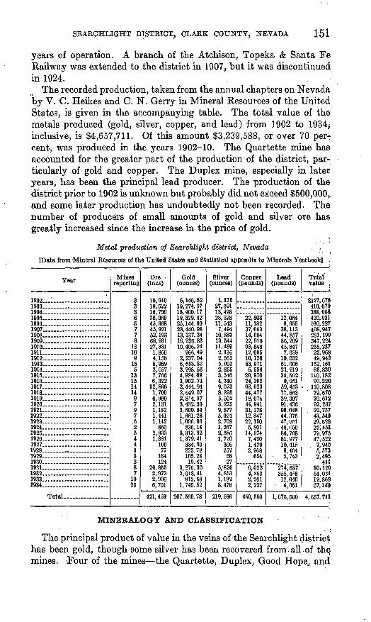
The recorded production, taken from the annual chapters on Nevada by V. C. Heikes and C. N. Gerry in Mineral Resources of the United States, is given in the accompanying table. The total value of the metals produced (gold, silver, copper, and lead) from 1902 to 1934, inclusive, is $4,657,711. Of this amount $3,239,588, or over 70 per^ cent, was produced in the years 1902-10. The Quartette mine has accounted for the greater part of the production of the district, par ticularly of gold and copper. The Duplex mine, especially in later years, has been the principal lead producer. The production of the district prior to 1902 is unknown but probably did not exceed $500,000,, and some later production has undoubtedly not been recorded. The number of producers of small amounts of gold and silver ore has greatly increased since the increase in the price of gold.
Metal production of Searchlight district, Nevada .'.'
[Data from Mineral Resources of the United States and Statistical appendix to Minerals Yearbook] .
Year
1902....... ..............1903 ....................1904..... ................. ..1905 ....................1906 1907 1908... ... ...............1909. __ ...................1910.. _ .. ____ .... .....1911........................1912 ............. ........1913 . ..1914 .. ........1915............... ..1916. __ .......1917 1918 - - 1919 .................1920....... .................1921 ...............1922. _ ...... _ . _ ... ....1923 ..... ___ .....1924.. _ .... ___ .........1925......... . ........1926 . .1927........ . _ ........1928 . .1929.... _ .................1930.......... ........1931....... .... ..1932...... _ ...............1933. 1934... .....................
Total........... .
Mines reporting
33365778
13109
156
131514149797
.6264433387
1025
Ore (tons)
10,91019, 52216,75038, 06945, 66845, 92152, 19368,93127, 3311,8504,1586,9893,0577,7666,322
12,8661,7006,9802, 1311,1821,4411.142
8502,8331,881
10677
184124
20, 8552,9732,9966,701
421,459
Gold (ounces)
6,146.5219, 274. 9718, 400. 1719, 329. 4225, 144. 6023, 440. 9813, 137. 3416, 236. 8310, 406. 24
966. 492, 237. 046, 653. 823,998.564, 984. 683, 902. 743, 444. 942, 649. 072, 8.r4, 373,432.363, 600. 641, 661. 281,006.96
830. 143, 313. 921, 879. 41
334. 90223. 78105. 2819.42
3, 276. 302,018.41
912. 581, 745. 52
207, 569. 78
Silver (ounces)
1,17527, 69113,49828,52811, 5437,494
' 10,88313,54411,4892,1362,5625,9032,8553,5464,3409,0738,3955,5026,2759,8776,0242,7081,2672, 5861,720
306252
5827
5,' 8264,8531,1828,478
219, 696
Copper (pounds)
22, 80811, 18237, 06314,95422,91693,84812,09510, 12653, 971
6, 55620,97024, 39298, 92344,47718,07444, 94131, 12812,84722, 1505,801
14, 9747,4301,4292,968
654
6,0224,3532,2612,237
650, 550
Lead(pounds)
12, 0649,655
38, 11344, 85736, 20945,8477,659
10, 03261. 00621.91935, 5629,951
59,45377,86339, 30791,43698,04844, 37547, 651
46,05086, 76881, 97710, 4159,464
2, 743
274, 687355, 458
12, 0404 OKI
1, 675, 560
Total value ,
$127, 678410,079388,068420, 931530,227498, 947281, 199347, 224235, 237
22, 96849, 942
152, 16185, 830
110, 18290. 220
110, 80879, 67070, 61292, 28792, 73743,54029, 62822; 45379, 97547,522
7,9405,5732,495
41180; 12954,03119, 869A? iAn
4, 657; 711
MINERALOGY AND CLASSIFICATION
The principal product of value in the veins of the Searchlight district has been gold, though some silver has been recovered from.all of the mines. Four of the mines the Quartette, Duplex, Good Hope, and
152 CONTRIBUTIONS TO ECONOMIC GEOLOGY, 1938-39
Big Casino have produced considerable lead and copper. In terms of recovered metals, 6 out of 10 mines yielded a larger proportion of gold than silver, mostly. 2 to 1 by weight. The Duplex mine yielded more gold than silver by weight during the first few years of produc-o tion, but the proportions were reversed during most of the later years. The product of the Quartette mine was highly variable, but mostly contained three times as much gold as silver by weight. The Cyrus Noble, Big Casino, and Searchlight Parallel mines produced from two to nine times as much silver as gold by weight during most of their years of operation. The amount of lead in the product of the Quar tette mine was about two-thirds that of copper, but the Duplex mine produced over three times as much lead as copper. Lead was more abundant than copper in the product of the Good Hope and Big Casino mines. To what extent these variations were due to differ ences in the processes of mining and milling used is not known.
With the exception of an unknown proportion of the ore of the Big Casino mine, the entire production of the district has come from oxidized or weathered ores. Weathering and leaching of vein materials has extended to the greatest depths attained in mining in all the veins of the main part of the district (pi. 41). Weathered vein material was found in the Quartette mine in.the lowest levels, more than 800 feet vertically below the present surface and more than 600 feet below
*>water level> when the mine was first developed. No zone of secondary sulphides is known to have been found in any of the mines. Galena is the only primary sulphide remaining to any extent in the weathered veins, where it occurs as scattered lumps surrounded by its weather ing products from a position within a few feet of the surface to the greatest depths of the ore shoots. Jaggar and Palache in a private report on the Quartette mine report traces of chalcopyrite and chal- cocite in that mine.
Unweathered vein material probably representative of that in many of the weathered veins was found on the dump at the Big Casino mine. ,It consists of a breccia of country rock cemented with quartz. Most of the quartz shows comb structure, and vugs are numerous. Sphalerite, galena, and chalcopyrite occur in the quartz, the first two in about equal proportions and the chalcopyrite mostly subordinate. Some of the country rock is silicified, contains scattered areas of sericite, chlorite, and carbonate, and has all three sulphides disseminated through it. Chalcopyrite is the most abundant sulphide in the sections of silicified material that were examined. Polished surfaces of the ores, examined by C. F. Park, Jr., reveal veinlets of galena and chalcopyrite in sphalerite and isolated rounded spots of sphalerite in chalcopyrite and galena. There appears to have been an overlapping in the sequence of deposition of the sulphides, though sphalerite is the earliest, and galena appears to be slightly later than
SEARCHLIGHT DISTRICT, CLARK COUNTY, NEVADA
chalcopyrite. No pyrite was seen in the material from the Big Casino vein. No assays of this material are available, but an output of 4,800 tons in 1 year yielded in terms of recovered metals 0.012 ounce of gold, 0.047 ounce of silver, and 0.367 pound of copper per pound of lead, according to data compiled by V. C. Heikes, of the United States Bureau of Mines. It is not known what proportion of the material shipped was primary sulphide ore.
The oxidation products of the veins in the southern part of the district, particularly the Quartette vein, and those on the Good Hope and Duplex properties indicate that the primar}7 ore contained appreciable quantities of sulphides. Several minor veins near these properties contain copper stain; a little copper-stained vein material occurs in veins near the Southern Nevada mine; and a very little copper stain was seen in a few pieces of vein material from the Blossom mine. The present composition of the other veins shown on the map does not indicate that they contained appreciable quantities of sulphides. The original presence of chalcopyrite is indicated by a group of copper silicates, carbonates, and sulphates. The presence of galena is indicated by cerusite, as well as by remnants of unweath- ered galena. The presence of sphalerite is indicated by the silicate hemimorphite (calamine) and by a minor amount of zinc, mostly less than 2 percent, hi smelter returns on the shipments of ore. No definite indication of pyrite was seen, though iron oxides occur in the weathered vein material. The quartz in the Quartette vein contains abundant original specular hematite, which is not found in appreciable quantities in the other veins. Veins in the northern part of the district reveal coarse-grained calcite, as well as lamellar calcite and quartz, and probably never contained appreciable amounts of sul phides.
A wide variety of oxidation products might be expected from the weathering of complex sulphide ores in a desert region. Jaggar and Palache 27 list the following minerals from the Quartette mine: Gold, copper (traces only), galena,chalcocite, chalcopyrite (minute amounts),, quartz, chalcedony, cuprite, hematite, cerusite, malachite, calcite,. brochantite (basic sulphate of copper), linarite (basic sulphate of lead and copper), leadhillite (sulphate-carbonate of lead), chrysocolla, wulfenite (lead molybdate), vanadinite (lead chlorovanadate), and mottramite (cuprodescloizite vanadate of lead, copper, and zinc). The writer also noted under the microscope the zinc silicate hemi morphite in radial aggregates in vein material from the dump at the Quartette mine. Greenish-yellow films of mottramite on other min erals are fairly common, and aggregates of vanadinite crystals are not uncommon. Orange-yellow tabular crystals of wulfenite were
>' Jaggar, T. A., Jr., and Palache, Charles, private report on Quartette mine, 1911.
154 CONTRIBUTIONS TO ECONOMIC GEOLOGY, 1938-39
recorded as fairly abundant in the Quartette mine and were noted in the Duplex mine. The secondary copper minerals, notably chrysocolla, yield bright-green and blue colors and are outstanding. They are mostly associated with the hydrous iron oxides, and their distribution indicates that the copper has migrated widely. They occur in masses, fill fractures, and stain or replace both country rock included in the vein and quartz. However, the lead carbonate ores, which occurred in lumps and masses, some of considerable size, con tained very little of the copper minerals. The average copper con tent of shipments of ore from the Duplex mine containing over 20 percent of lead was 1.42 percent, whereas that in ores having a lower lead content was over twice as much, or 2.90 percent. The fact that the lead carbonate ores tended to occur in lumps and masses indicates that lead did not migrate as readily as the copper under oxidizing conditions. All the calcite seen in these mines occurs as crystals and films on the secondary minerals or on surfaces of fractures. Some secondary quartz was observed as clear crystals on the surfaces of secondary copper minerals. Clay minerals, apparently mostly of the beidellite type, occur in cavities in the weathered ore and particularly in the country rocks.
Gold and silver are not ordinarily visible in any of the ores, though fine specimens of wire gold on the surface of green vein material were said to have been obtained from the Quartette mine. Under the microscope a specimen of high-grade ore from a pillar in the Burdick stope on level 5 of the Duplex mine revealed irregular grains and flakes of gold in quartz and in spots of brown iron oxides. Assays indicate that gold is more abundant in the coatings of lead carbonate adjacent to galena than in the galena itself.
The veins of the Searchlight district can be classified in various ways. All the minable ores have been of value chiefly for the gold and would be broadly classed as siliceous gold ores. All the vein material is leached and weathered, with the exception of part of that in the Big Casino mine, so that the ores could be classed as oxidized. The ores of the Quartette, Duplex, Good Hope, and Big Casino mines give evidence of an original content of the sulphides of lead, copper, and zinc, so that they could be classified as complex sulphide or base- metar veins with gold. Probably the other veins that have little evidence of original sulphides had a sparse distribution of sulphides and belong to this group. As they occur in partly metamorphosed lavas of probable Tertiary age, they are included by Ferguson 28 in the group associated with Tertiary lavas. They are associated with and are later than a large body of quartz monzonite, thus differing from most of the Tertiary mineral deposits in western Nevada. How-
ss Ferguson, H. G., The mining districts of Nevada: Econ. Geology, vol. 24, p. 135,1929.
SEARCHLIGHT DISTRICT, CLARK COUNTY, NEVADA 155
ever, it must be held in mind that they may not be genetically related to the quartz monzonite, and that their position is determined by regional fracturing in less competent rocks around the border of the very competent quartz monzonite body. They also differ from many of the areas of Tertiary mineralization in lavas in western Nevada in the high proportion of base metals in the shipments and in the high proportion of gold to silver (about 1 to 1, as compared to 1 to 10 .or even 1 to 100 for many other districts),. Even the ore from the nearby Eldorado Canyon district is materially, different, both in the gold-silver ratio and in the abundance of base metals. In general, the Searchlight ores resemble both in structure and in metal content the ores of the Cascade Range in Oregon.29 The district has been in cluded by Burbank 30 in the group of epithermal base-metal deposits, of which it is the only representative in Nevada.
VEIN STRUCTURE
Of 34 veins in the district, 25 strike between S. 80° W. and N. 57* W., though N. 65° W. is the most common trend. Of these 25, 3 dip north and the remainder dip south. Four veins strike about N. 40°' W. and dip southwest. One vein strikes about N. 40° E. and dips southeast. Four veins trending from N. 8° W. to N. 10° E. dip west. The fault that offsets the vein hi the Duplex mine strikes about N-» 10° E. and dips about 25° E. The fault in the G.ood Hope mine strikes about N. 35° E. and is nearly vertical. A probable fault at the Blossom mine strikes N. 13° E. and dips 36°-43° E. The domi nant trend is west-northwest and is followed by the veins that produce almost all the ore. Two veins that strike nearly at right angles to the general trend have had a relatively small production. The dominant dip is to the south. The angle ranges from 20° to 80°, though 45° is a common angle, and almost all the mine shafts are inclined. ;
The dimensions of the veins vary widely. The Quartette vein and the Rambler vein, which extends on to the southeast, have an aggre gate length of nearly 3,500 feet and have been explored underground for nearly 2,100 feet. The New Years Gift vein of the Duplex mine has been explored for 1,180 feet underground. The productive part of the Quartette vein was about 900 feet long, according to old maps, and the productive part of .the New Years Gift vein was about 1,100' feet long. The Quartette vein was productive to the 1,100-foot level, about 920 feet down the dip of the vein, or 740 feet vertically below the surface. Stopes extend almost to the 700-foot level of the Duplex mine, 540 feet below the surface on the incline, or 400 feet vertically
M Callaghan, Eugene, and Buddington, A. F., Metalliferous mineral deposits of the Cascade Range Itt Oregon: U. S. Qeol. Survey Bull. 893, pp. 24-29, 33-35,1938.
*<> Burbank, W. S., Epithermal base-metal deposits: Ore deposits of the Western States-(Lindgren vol ume), p. 651, Am. Inst. Min. Met. Eng., 1933.
156 CONTRIBUTIONS TO ECONOMIC GEOLOGY, 1938-39
below the collar of the Fraction shaft. Many of the other veins were stoped only near the surface and even the barren quartz veinlets largely faded out within 200 feet vertically below the surface. Stope maps indicate that the ore shoot or group of ore shoots in the Quartette mine'pitched to the east1, and those in the Duplex mine pitched ; very gently, about 10°, to the southeast. The principal ore shoot at the Blossom mine was saucer-shaped and nearly flat. The group of ore shoots on the southward-dipping vein at the Blossom mine, though very irregular, pitched to the west.
The structural features of the veins reveal the nature of the pre- mineral movements that opened the fissures and produced the breccias where the vein material was deposited, as well as the postmineral movements that have made new fractures extending through the ore or along footwall and hanging wall producing in many places a breccia of the ore. - Thus at the present time many veins are made up of lenses of vein material and lenses or horses of country rock that are separated by gouge seams; in places the richest ore is found in such lenses. There are also quartz veins and veinlets disclosed by crosscuts-within both the hanging wall and the footwall of the main part of the vein; these indicate that the primary fracture was a central large break, parallel to which were numerous minor breaks of varying magnitude and continuity. In places ore has been found on these parallel fissures. Sections from old maps indicate that large stopes were made along the top of a lens within the vein. In most of the mines the best ore was limited to a central zone a foot or two in width, but in the larger mines stopes are 10 feet or more wide, and some in the Quartette mine were 50 feet wide. In the Duplex mine and particularly in the Blossom mine, the most productive parts of the vein were those that were most nearly horizontal. The origin of these nearly flat veins is not readily understood, as they do not appear to have been controlled initially by preexisting structure, nor is there any good evidence of thrust faulting. It is evident, par ticularly at the Blossom mine, that only a very slight displacement has been sufficient to cause the observed brecciation of the country rock.
Most of the veins show a breccia of country rock cemented with porous and vuggy comb quartz (pi. 44). Clay minerals partly fill some of the cavities, and some of the vugs are partly lined with calcite. Secondary lead and copper minerals and iron oxides partly or wholly fill fractures and cavities in some of the veins. Postmineral move ments along the veins crushed the ore, as well as the nearby country rock, particularly in the Quartette mine, so that the ore as mined was soft and tended to cave and slump in the workings. The quartz characteristically does not form large solid masses. Veins in the northern part of the district, particularly the Pompeii, contained
SEARCHLIGHT DISTRICT, CLARK COUNTY, NEVADA 157
lenses of calcite, a part of which is interlaycred with quartz. Breccia- tion in these veins does not appear to have been extensive, but numer ous quartz veinlets occur in partly or wholly adularized and silicified country rock.
BOCK ALTERATION
The country rock of the veins has been modified to a variable extent, first, by emanations that escaped during or soon after the crystalliza tion of the quartz monzonite; second, by the vein-forming solutions, which were later and may have had a source unrelated to the quartz monzonite; and, third, by the still later supergene (descending) solu tions charged with acids that were formed by weathering of the primary ores. The first type of alteration is treated in the descrip tion of the older volcanic rocks on pages 142-143. It is related geo graphically to the periphery of the quartz monzonite, and the modifica tions it imposed on the intruded rocks are similar throughout the district. The principal minerals formed epidote or clinozoite, quartz, and magnetite are related in their distribution to the contact of the monzonite and bear no relation to the veins, unless the fractures later occupied by the veins happened to be in existence at this' early time. On the other hand, the effects of alteration by the vein-forming solutions differ from south to north and suggest a poorly defined zonal arrangement in this direction, not related to the outcrop of the quartz monzonite.
In the southern part of the district the vein-forming solutions do not appear to have appreciably modified the adjacent hornfels, andesite porphyry, and quartz monzonite. Feldspar phenocrysts in rock adjacent to veins are fairly well preserved. Seficite, chlorite, and fine-grained quartz in primary ore from the- Big Casino mine indicate some degree of attack of wall rock by vein-forming solutions. Whether any of the epidote in any part of the district is related to the vein-forming solutions is not definitely known. Epidote associated with quartz and calcite in minute veinlets may possibly be related to the vein-forming period, but no definite evidence for such a relation was found. In general, the wall rocks in the southern part of the district have been relatively unaffected by the vein-forming solutions.
In the northern part of the district, particularly at the Pompeii mine, the volcanic rocks and andesite porphyry, which are the wall rocks of quartz-calcite veins, have been altered to a yellowish rock composed largely of a microscopic aggregate of adularia and quartz with remnants of primary minerals. Ferromagnesian minerals and any previously formed epidote have been . eliminated from this material.
Perhaps some clue to the nature of the vein-forming solutions may be obtained from the type of wall-rock alteration, as well as from the vein minerals themselves. The lack of appreciable wall-rock alteration,
158 CONTRIBUTIONS TO ECONOMIC GEOLOGY, 1938-39
particularly of the feldspars, in the southern part of the district sug gests., that the solutions were only weakly alkaline. The abundant adularia associated with quartz-calcite veins in the northern part of the district suggests that these solutions were strongly alkaline or at least contained considerable quantities of potash. The general lack of pyrite throughout the district suggests that all the solutions were unusually deficient in iron. However, the hematite in the Quartette vein indicates that at one stage, probably the earliest, the solutions in this particular vein contained considerable iron. This large vein probably provided more ready access for vem-forming solutions, so that: the temperatures were higher than in the other veins. The temperatures may have been sufficiently high to favor the precipita tion of iron as oxide, even in the presence of sulphur. However, absence of sulphides in this stage may simply imply the absence of sulphur without reference to temperature. The presence of hema tite suggests furthermore that the solutions were not highly alkaline and may have been distinctly acid at the time the hematite was precipitated. Succeeding solutions that deposited metallic sulphide were probably slightly alkaline and slightly cooler.
The later volcanic rocks have been affected by alteration of a differ ent type, in which large areas of rock were changed to clayey aggre gates with a little fine-grained quartz or chalcedony. These rocks are variably colored from white to red and are commonly iron-stained. West of the Chief of the Hills mine the andesite porphyry is also altered to a soft rusty rock along a zone normal to the vein. This alteration was probably much later and had nothing to do with the veins.. The later supergene alteration near those veins that originally con tained appreciable quantities of sulphides has changed much of the original feldspar that survived the attack of vein-forming solutions into aggregates of clay minerals, chiefly of the beidellite type. Such rock commonly contains numerous fractures and slickensides, and though hard when first encountered readily disintegrates when ex posed to damp air. The previously adularized and silicified rock in the northern part of the district does not appear to have been greatly affected by supergene solutions.
AREAL ZONES OF THE MINERAL DEPOSITS
There is a suggestion that some features of the veins as well as wall rocks are zonally distributed in the district. This zonal distribution is illustrated chiefly in the differences between the minerals and wall- rock alteration exhibited in the Quartette mine, on the south, and the Pompeii and J. E. T. mines, on the north. The Quartette vein evi dently originally contained the sulphides of lead, zinc, and copper as well as abundant specular hematite distributed through the quartz.
SEARCHLIGHT DISTRICT, CLARK COUNTY, NEVADA 159
Wall-rock alteration was comparatively slight. The product of the mine contained more gold than silver and more copper than lead. In the product of the Duplex mine, to the north, silver is slightly domi nant over gold, and lead is dominant over copper. A few of the veins as far north as the Southern Nevada contain a little copper stain that indicates an original sulphide content, but they appear to grade by diminution of original sulphides so that those farthest north con tained very little. A little coarse-grained and lamellar calcite was found in the Searchlight M. & M. and Blossom veins, and the lower workings on the Pompeii vein reveal lenses of coarse and lamellar calcite with quartz. Two large calcite veins crop out on the J. E. T. property. Adularization and silicification of wall rock is evident at the Pompeii, and wall rocks in many of these northern veins are iron- stained and yellowish rather than greenish or gray, as in the southern part of the area.
It might be supposed that the two extremes represent two types and two ages of mineralization, but there appears to be a gradual transition from one to the other. Furthermore, the veins in the north still preserve the high ratio of gold to silver and thus differ materially from the calcite-bearing veins of the Eldorado Canyon district, which show a high ratio of silver to gold. ; ,
It is obvious that this suggested zoning is decidedly eccentric with respect to the quartz monzonite. It indicates that uniform heat from the quartz monzonite body did not control the apparent zoning. Either one part of the body had cooled more quickly than the other, or there is no close genetic connection between the mineralization and the quartz monzonite body in its present form. If related in any way to the quartz monzonite, the solutions may have risen from some deep- seated part of the magma long after the part now in view had solidified and cooled. The relationship may be wholly fortuitous, only the belt of fracturing having been determined by the competent quartz monzo nite body, and much later mineralization having been related to some igneous mass not now exposed. Study of a much larger area would probably clarify these relations.
OUTLOOK FOB THE DISTBICT
The veins of the Searchlight district are unusual among those associated with lavas in Nevada, in yielding a relatively large pro duction of base metals and a high ratio by weight of gold to silver, essentially 1 to 1. Like many other districts, however, after an initial period of high yield of about 10 years there was a long decline but continuous annual production to the present time. It seems that a small production, chiefly from leasing operations, may be expected for several years, particularly with the maintenance of the^increased price of gold. Higher prices of silver or base metals will have little
160 CONTRIBUTIONS TO ECONOMIC GEOLOGY, 1938-39
effect, as the known base-metal ore bodies have been worked out, and silver forms but a small part of the value of the metal won.
The cost of mining and milling at the Quartette mine, according to Ransome 31 was between $5 and $6 a ton in 1906, before the advent of the railroad. . At that time about 75 tons of ore was hoisted daily and milled in the 10-stamp mill. No other data on costs of mining and milling or of shipments to smelters were available. Lessees at the Duplex mine are said to have tried to maintain an average gross value of about $90 a ton on shipping ore, in order to make a good profit. In the last few years the mills at the Duplex and Quartette mines have worked tailings mostly.
Apparently water has been ample to meet the needs of such mills as have operated in the district. Water for milling at the Quartette mine is obtained from the mine and from the Drake shaft, northwest of the mine. The Santa Fe shaft evidently yielded ample water for the Duplex mill from a vertical depth of about 145 feet. The Search light M. & M. shaft yields a large flow from a depth of about 280 feet. The Spokane shaft of the Southern Nevada mine yielded ample water for a 10-stamp mill from a depth of about 200 feet. The Pompeii shaft yields abundant potable water, estimated at 65,000 gallons a day, from a vertical depth of about 240 feet.
Explorations below the known ore shoots have been discouraging. Available'data on the Quartette mine indicate that two levels were run below the bottom of the ore shoot near the 1,100-foot level without revealing further ore, though oxidation products, gouge seams, and quartz stringers continued. Long crosscuts were driven in both hanging wall and footwall without revealing more than a few barren quartz stringers parallel to the principal vein. Explorations on levels 7 and 8 of the Duplex mine revealed only quartz stringers and gouge seams, which are reported to have assayed no more than a trace of gold. Only quartz stringers and gouge seams appear on level 4 at the Searchlight shaft below the prominent ore shoot on the upper levels. Level 3 at the Blossom mine reveals minable ore shoots passing into thin quartz stringers in country rock. These narrow seams must have been the channels of access of the ore solutions, but their diminution with depth does not favor the hypothesis that they may lead to deeper ore shoots. The shafts at the Cyrus Noble and Searchlight Parallel mines also show this tendency for the grade and amount of the ore to decline with depth. Several experiences such as these throughout the district appear to indicate that the veins have been "bottomed" and that deeper ore shoots do not occur. However, no convincing geologic reason for such shallow depths for these veins can be given, and deep drilling on so large a vein as the
« Ransome, F. L., op. cit., p. 71.
SEARCHLIGHT DISTRICT, CLARK COUNTY, NEVADA 161
Quartette might reveal a much deeper ore shoot. It is probably true that the faults occupied by the veins are not large. Apparently the amount of relative displacement was small, and it decreased toward the ends of the fractures as well as in depth.
The immediate hope for continuity in production from the district appears to lie in further exploration along the strike of some of the veins, exploration of faulted segments, particularly in the direction of pitch of ore. shoots, and searches for ore bodies within the footwalls or hanging walls of previously worked-out veins. Further and deeper exploration on the downthrown side of faulted segments, particularly in the Duplex mine, may disclose more ore shoots. De tailed studies of individual veins, especially of branching seams, may lead to the discovery of minor ore shoots within the footwalls and hanging walls. Such explorations will probably result in a continued small production from the district.
MINES AND PROSPECTS
PRINCIPAL MINES IN THE MAIN PART OF THE DISTRICT
QUARTETTE
The Quartette mine is the southernmost in the district and has been by far the largest producer. It has accounted for 64 percent of the gold, 21 percent of the silver, 58 percent of the copper, and 13 percent of the lead recorded for the district. The total yield is probably over $2,800,000 and was produced in the years 1902 to 1921 and in 1923. The main points in the history of the mine are given on pages 150-151. The property consists of 13 patented claims and fractions, which lie mostly in sees. 2 and 3, T. 29 S., R. 63 E. The vein crops out on the Golden Treasure, Copper King, and Rambler claims.
The extensive workings of the mine shown on the accompanying map (pi. 45) were wholly inaccessible in 1931, but in 1934 shaft 3 had been cleaned out to water level (between the 600- and 700-foot
.levels) for the installation of pumping equipment, and new work on the 400-foot level was accessible. A short drift on the 100-foot level at the north end of the mine was also accessible. According to the report in Mineral Resources of the United States for 1911, when operation by the company ceased, the depth of the main shaft on the incline was 1,167 feet, and the total length of workings was 5% miles. The map indicates that 13 levels explore the vein for a maximum distance of 2,100 feet. As shown by the map, the length of the part of the vein wholly or partly stoped is nearly 1,000 feet. Most of the stoping was done in the part of the vein between the main shaft and shaft 3, which are 500 feet apart at the surface but diverge in depth. Most of the stopes lay between the 100- and 1,100-foot levels, though lessees have opened stopes at the surface between the main shaft and
162 CONTRIBUTIONS TO ECONOMIC GEOLOGY, 1938-39
shaft 3. The map shows that the main ore body or group of ore bodies pitched to the southeast.
The country rocks of the Quartette or Golden Treasure vein are chiefly gneiss, hornfels, and andesite porphyry. Jaggar and Palache in a private report list dikes of biotite andesite, which traverse the andesite porphyry and older rocks and which were referred to as "neoaridesite." Jaggar's map, reproduced by Ransome,32 shows the irregular contact of the gneiss and hornfels at right angles to the vein near the approximate location of shaft 3, though the workings show that the gneiss is more abundant in the footwall and the hornfels more abundant in the hanging wall. Jaggar and Palache state that there has been displacement of the contact along the vein, with the relative positions of the gneiss and hornfels as shown by the mine map (pi. 45). They 'also state that flows forming the hornfels lie on the gneiss and dip 40° N. The andesite porphyry cuts both the gneiss and the hornfels, so it occurs in both walls of the vein as both steeply dipping and gently dipping dikes and irregular-shaped masses. Specimens from the vein show very little alteration of country rock by the primary vein solutions, but wall rocks along much of the vein have been transformed to clayey aggregates, presumably by supergene solutions accompanying the weathering of the vein.
The vein, as revealed by workings and prospect pits on the surface, has a length of 3,300 feet. The average trend is N. 70° W., but the trend at the mine, which is on the north end of the vein, is N. 65° W. The north end curves more to the northwest. The vein is variable in trend and dip, as indicated by the plan (pi. 45) and particularly by the cross sections (pi. 46)., The dip at the north end of the vein on the 100-foot level is 40° S., but it steepens to 50°-60° throughout most of the mine. Dips of 72° S. were observed at the Rambler workings on the ridge. According to the map (pi. 45), the vein was explored to the 1,300-foot level, a distance of 1,160 feet on the incline, or 868 feet vertically below the surface. Such information as is. available indi cates that the slip planes or postmineral fractures and some quartz, but no ore, were exposed below the 1,100-foot level.
The structure of the vein is complex, as indicated by the map and particularly by the sections. As shown in the new work on the 400- foot level (pi. 45), numerous intersecting gouge seams enclose lenses of quartzose vein matter and lenses of country rock as well. Some of the lenses of ore were stoped to widths of 50 feet, according to Ransome.33 Crosscuts show that gouge seams and quartz veins or veinlets, mostly parallel to the main vein, occur in both the footwall and hanging wall. The sections (pi. 46) suggest that the large stopes were opened at the tops of lenses formed by large splits in the vein.
" Ransome, F. L., Preliminary account of Qoldfleld, Bullfrog, and other mining districts In southern Nevada: U. S. Qeol. Survey Bull. 303, p. 70, 1907..
>« Ransome, F. L., op. cit., pp. 70-71.
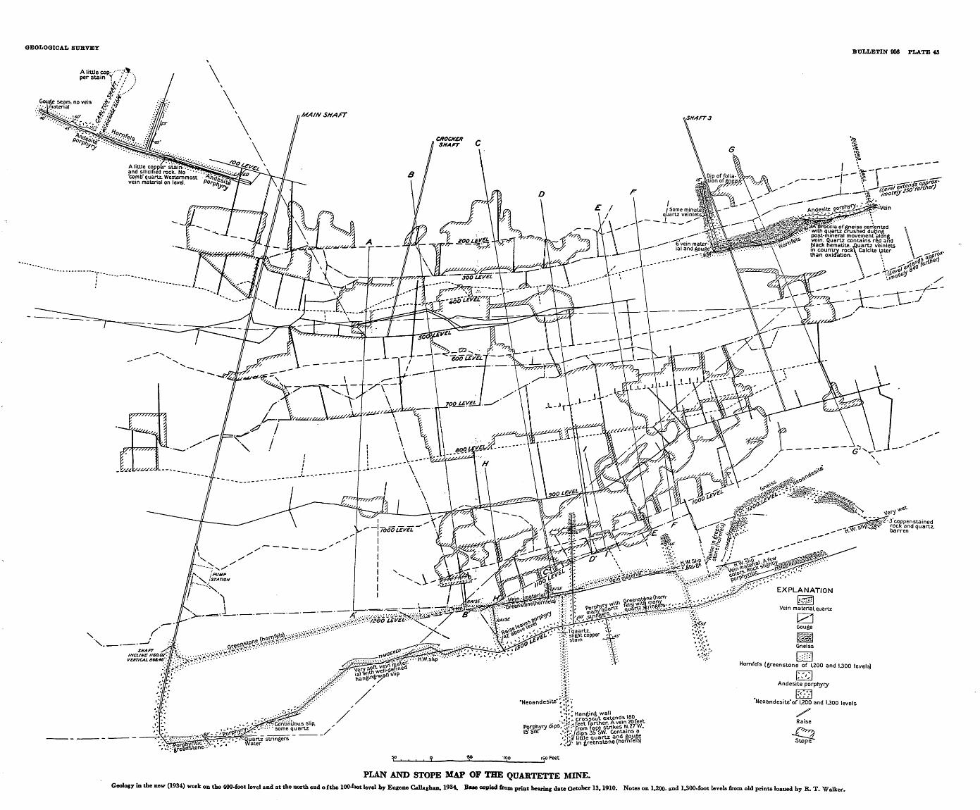
GEOLOGICAL STJBVETBULLETIN 906 PLATE 45
A liUJe cop-/ "?>-.. per stain 7 / < ' :
SHAFT3
ia of gneiss cerrfented with quartz crushed during post-mineral movement along vein. Quartz contains red and black hematite. .Quartz vein letsn country rock\ Calcite later
than oxidation.
EXPLANATION
Vein material.quartz
^LGouge
Gneiss
Homfels (greenstone of 1.200 and 1.300 levels)
Andesite porphyry
"Neoandesite"of 1.200 and 1.300 levels
/Raise
^rr
Stope
-f??:vCdntinilDus slip. ' some quartz
PLAN AND STOPE MAP OF THE QUARTETTE MINE.Geology in the new (1934) work on the 400-foot level and at the north end o fthe 100-foot level by Eugene Callaghan, 1934. Bue copied from print bearing date October 13, 1910. Notes on 1,200- and 1,300-foot levels from old prints loaned by R. T. Walker.
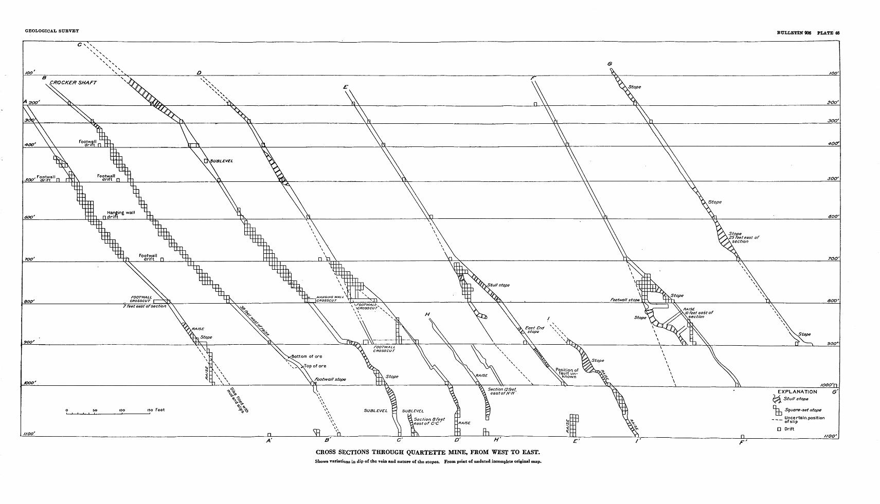
GEOLOGICAL SURVEY BULLETIN 006 PLATE 46
CROSS SECTIONS THROUGH QUARTETTE MINE, FROM WEST TO EAST.Shows variations in dip of the vein and nature of the slopes. From print of undated incomplete original map.
SEARCHLIGHT DISTRICT, CLARK. COUNTY, NEVADA 163
Ransome 34 describes the ore as follows:The ore is ordinarily a soft shattered mass of altered country rock intimately
mingled with the various ore minerals. It is generally oxidized, but a little chalco- cite is said to be occasionally found, and some residual kernels of galena were seen in the west drift of the eighth level. Good ore is nearly always associated with chrysocolla or with earthy cuprite and in some places carries from 10 to 12 percent copper. Small cupriferous bunches are sorted and shipped. Where galena or, more commonly, cerusite appears the ore ca.rries a larger proportion of silver than where copper is the dominant base metal. Wulfenite, the molybdate of lead, in characteristic square, tabular orange-colored crystals, is very common throughout the mine and does not necessarily indicate ore. It is apparently one of the later products of oxidation and occurs in little vugs and open fissures, implanted on the other minerals. Hematite is abundant but, like the wulfenite, does not seem to be particularly characteristic of good ore. Quartz is widely distributed through the lode but never forms large or solid masses. Its most typical occurrence is in small vugs and veinlets.
Jaggar and Palache in a private report state that the usual ore consisted of gold-bearing quartz more or less deeply stained with chrysocolla and in places containing large masses of lead carbonate. Their mineral list is given on page 153. Material collected by the writer from a dump near shaft 3 consisted of a porous aggregate of quartz stained mostly brown and containing chrysocolla and malachite, as well as radial aggregates of hemimorphite (calamine, hydrous sili cate of zinc), visible under the microscope. Specular hematite occurs in plates and sheafs in much of the quartz but is turned red in most of the material examined. The hydrous oxides of iron are present in most of the specimens.
According to available information postmineral faults offset the vein at various places, and the vein appears to be offset on the surface east of shaft 3. Postmineral movements have brecciated the primary ore and have facilitated the weathering of the vein down as far as operations extended and well below the present water level, which in December 1934 was between the 600 -and 700-foot levels, or about 400 feet vertically below the surface. Ransome states that water was struck originally 180 feet below the surface. According to Hewett,35 the reported water yield of the mine was 25,000 to 30,000 gallons a day.
The available information and maps indicate that a group of ore bodies extending chiefly from the 200-foot to the 1,100-foot level at the north end of the Quartette or Golden Treasure vein and attain ing widths as great as 50 feet were stoped. The value of the ore varied widely, and Ransome states that ore worth $25 to $40 a ton, at the old price of gold, was considered good ore, though some worth $400 a ton was being stoped in 1906. The cost of mining and milling
34 Ransome, F. L., op. cit., p. 71.35 Hewett, D. F., in Thompson, D. Q., The Mohave Desert region, California: U. S. Geol. Survey Water-
Supply Paper 578, p. 720, 1929.136973 39 3
164 CONTRIBUTIONS TO ECONOMIC GEOLOGY, 1938-39
was between $5 and $6 a ton before the completion of the railroad. Mining was carried on by the company until 1911, when extensive explorations failed to yield new ore bodies. The mine was operated under a leasing system from 1911 to 1921, and lessees since that time have produced a little ore from rock near the surface. The ground is reported to have been soft and required extensive timbering. Almost all the levels are closed, and any new exploration in a mine that was probably extensively explored over so long a period of productive history would be very costly, with little assurance of revealing suf ficiently large bodies to mine. Nothing is known to the writer of any successful development of ore shoots in the eastern or Eambler portion of the vein, nor is it known how extensive explorations in that area may have been. The vein is so long, however, that the possibility of an ore shoot in this area should be entertained.
GOOD HOPE (PHOENIX)
The Good Hope property adjoins the Quartette on the north and consists of four patented claims, one of which is a fraction. Three veins crop out on the Good Hope claim, and the middle vein has been explored by the workings shown in plate 47. The recorded produc tion is very small, but between 1906 and 1911 probably the mine pro duced some ore that was included with that of the Duplex. It is credited with production in 1913, 1921, and 1933, and lessees were reported to be active in 1934.
The vein has been explored by two shafts, one 210 feet deep and the other about 370 feet deep on the incline, together with 1,350 feet of drifts and 920 feet of crosscuts on four levels, shown in plate 47. Some small stopes have been opened on the 200-foot level, but most of the stoping has been in the vicinity of the air shaft between the 60-foot level and the surface. The strike of the vein is variable but averages N. 70° W. The dip also changes from place to place but is mostly 40°-50° SW. The most conspicuous feature is a nearly ver tical fault, which, if interpreted as a normal fault, indicates a drop on the west side of about 100 feet. (See pi. 48.) The country rock is chiefly hornfels, but dikes and masses of andesite porphyry are revealed on most of the levels.
The vein has been explored for a length of 340 feet underground, and pits on the surface indicate a length of 1,000 feet. The vein material near the surface in the vicinity of the air shaft consists of a zone 6 feet wide made up largely of altered rock but contains 26 inches of quartz-cemented breccia on the footwall and 6 inches on the hang ing wall. The vein material in the upper workings is stained with copper silicate and iron oxides, but both quartz and copper stain are largely wanting on the 300-foot level. No assays were available.
SEAECHLIGHT DISTRICT, CLARK COUNTY, NEVADA 165 '
According to Hewett, 36 the vertical depth to water is 225 feet, and the reported yield 5,000 gallons a day.
The fading out of the vein in the lower workings is not encouraging for prospecting at depth, and further production will probably be limited to small operations near the surface.
The two parallel veins, one on each side of the main vein, have been prospected by shafts, inaccessible in 1931, and open cuts. The dip of the southwesterly vein is 56° SW., and that of the southeasterly vein is 48° SW. Both are narrow quartz veins in hornfels and ande- site porphyry.
DUPLEX
The Duplex mine is on the hill south of Searchlight, and the six patented claims and a fraction constituting the property lie largely in the southwest corner of sec. 34, T. 28 S., K. 63 E. It is second only to the Quartette, both in production and in amount of develop ment work. According to an engineer's report, the property was located May 6, 1897, by G. F. Colton as the IXL copper mine, and some ore was shipped to a smelter at Pueblo, Colo. In 1903 it was one of three mines equipped with mills. From 1904 to 1907 it was included with the Good Hope mine as one operation under John Brockman. From 1911 to 1915 it was held by the Homestead Mining <fe Milling Co. The Duplex Mining Co. operated the property from 1915 to 1918, but subsequent intermittent operations were carried on by lessees until 1930, when the Searchlight Gold Corporation took over the property. This company erected a 100-ton flotation mill, which treated tailings from earlier operations, some ore from the dump, and ore from pillars and small stopes in the mine. Operations by the company ceased in 1931, and the mill was later dismantled. Lessees in 1934 extended level 8 northward to a raise connecting with workings on level 4 from the Searchlight shaft, and the Searchlight shaft was unwatered. No new ore was developed. The mine is credited with production in 1903, from 1906 to 1911, in 1913, and from 1915 to 1934. The total production probably exceeded $650,000 and was derived chiefly from gold, but a considerable yield of lead with silver and copper was obtained, particularly in the later leasing operations.
The underground workings of the mine are accessible from three shafts the New Years Gift, Fraction, and Searchlight. Jvlost of the later operations were carried on by way of the Fraction shaft. The distribution of the workings that were accessible in 1931 and 1934 is shown in plate 49, and a longitudinal section on the Fraction and New Years Gift veins is shown in figure 24. The Fraction shaft attains a
« Hewett, D. P., op. cit. (Water-Supply Paper 678), p. 720.
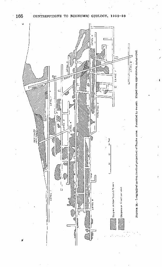
Slo
pes o
n N
ew Y
ears
Gift
ve
in
Slo
pes o
n F
ractio
n v
ein
Oi
O5
LE
VE
L 8
FIG
UR
E 2
4.
Lo
ng
itu
din
al s
ecti
on (
vert
ical
pro
ject
ion)
of
Dup
lex
min
e.
Fur
nish
ed b
y o
wne
rs.
Sto
ped
area
s ap
prox
imat
e, u
nsur
veye
d.
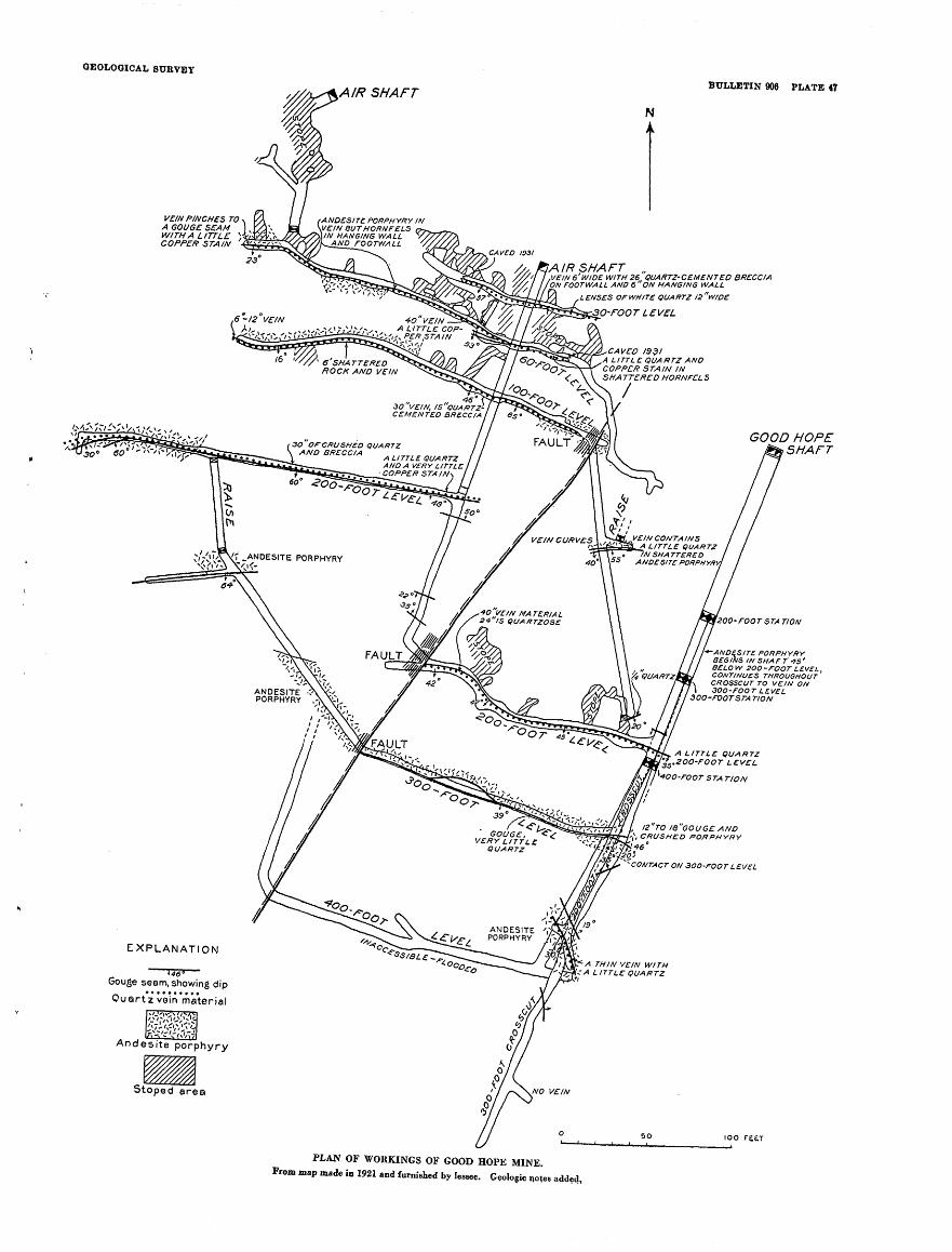
GEOLOGICAL SURVEY
BULLETIN 906 PLATE 47
VEIN PINCHES TO A GOUGE SEAM WITH A LITTLE } COPPER STAIN
1 AIR SHAFT ,VEIN 6' WIDE WITH 26 QUARTZ-CEMENTED BRECCIA ON FOOTWALL AND 6 ON HANGING WALL
ANDESITE PORPHYRY IN VEIN BUTHORNFELS IN HANGING WALL
AND FOOTWALL
LENSES OF WHITE QUARTZ !2w/DE
4O VEIN A LITTLE COP-
CAVED 1931 A LITTLE QUARTZ AND COPPER STAIN IN SHA TTERED HORNFEL S
30 'VEIN, IS"QUARTZ- CEMENT ED BRECCIA
3O OfCRUSHED QUARTZ AND BRECCIA A LITTL£ Q(JAKT2
AND A VERY LITTLE COPPER STAIN
A LITTLE QUARTZ
ANDESITE PORPHYRY
A LITTLE QUARTZ .ZOO-FOOT LEVEL
+00-FOOT STATION
12 TO i8"GouGE AND>, CRUSHED PORPHYRY
"-CONTACT ON 3OO-FOOTLEVEL
ANDESITE PORPHYRY
EXPLANATION
Gouge seam, showing dip
Quartz vein'm'aterial
Andesite porphyry
GOOD HOPE SHAFT
-rOOT STA TION
-ANDESITE PORPHYRY BEG INS IN SHA r T 45 ' BELO W 2OO-FOOT LEVEI CONTINUES THROUGHOUT CROSSCUT TO VEIN ON 3OO-FOOT LEVEL
30O-rOOTSTA TION
IOO re&T
PLAN OF WORKINGS OF GOOD HOPE MINE. From map made in 1921 and furnished by lessee. Geologic notes added,
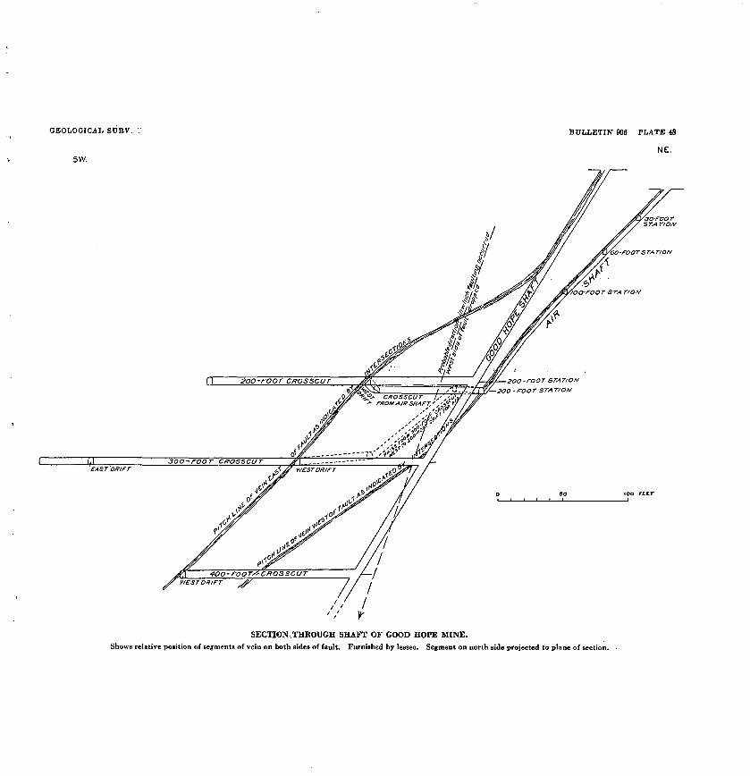
GEOLOGICAL SURV.
sw.
BULLETIN 906 PLATE 48
NE.
CKOSSCUT1, FKOM AIR SHAFT,'
SECTION.THROUGH SHAFT OF GOOD HOPE MINE.
Shows relative position of segments of vein on both sides of fault. Furnished by lessee. Segment on north side projected to plane of section.
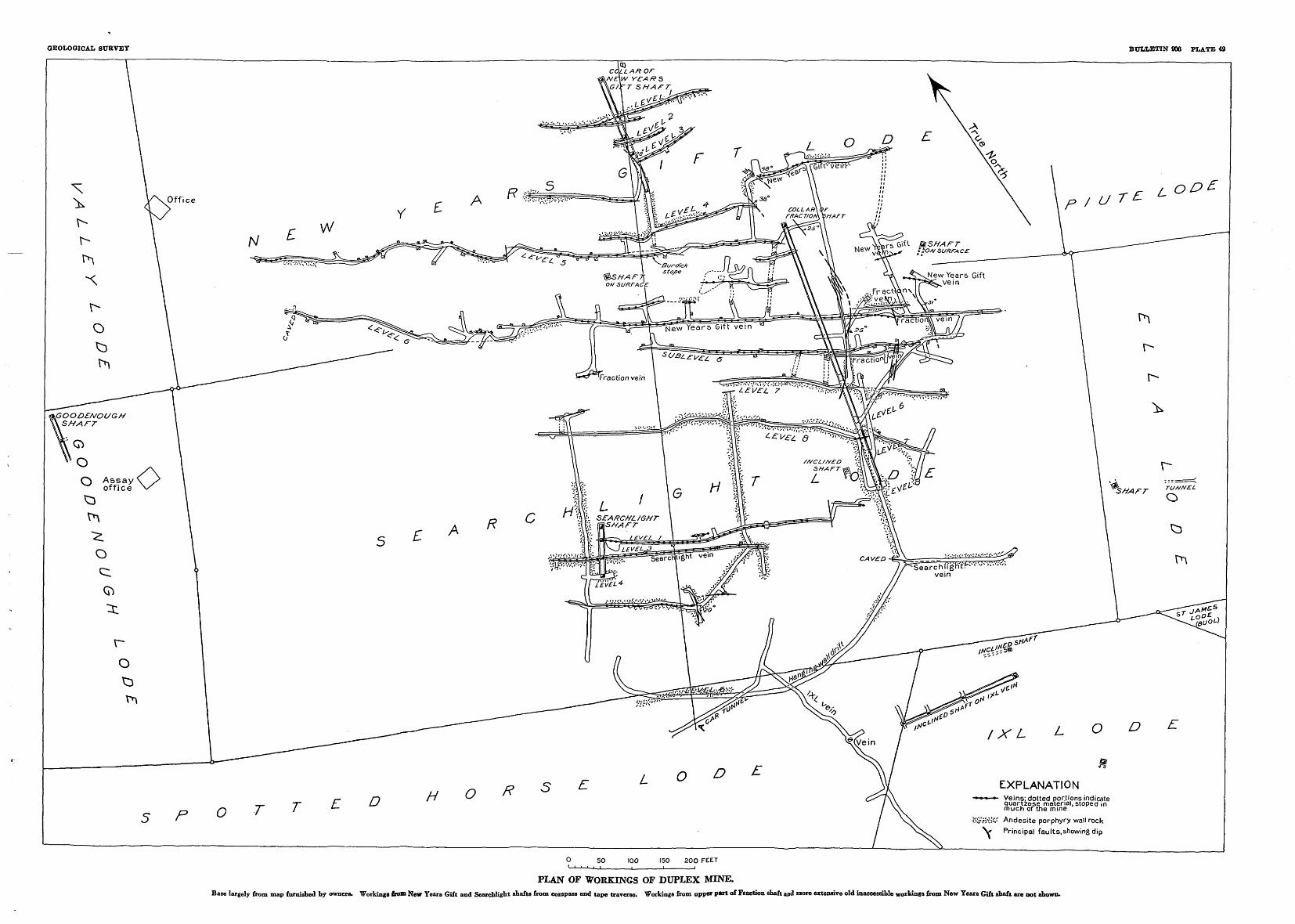
GEOLOGICAL SUBVEY BULLETIN 906 PLATE 49
GOODEMOUGH SHATT
Veins; dotted portions indicate quartzpse material, stoped in much of the mine
c'3'M'o1'".' Andesite porphyry wall rock
Principal faults,showing dip
0 5O 100 150 20O FEET ' ' ' i_i______i_ i i
PLAN OF WORKINGS OF DUPLEX MINE.Base largely from map furnished bv owners. Vorkinga from New Years Gift and Searchlight shafts from compass and tape traverse. Workings from upper par. of Fraction shaft and more extensive old inaccessible workings from New Years Gift abaft are no, shown.
SEARCHLIGHT DISTRICT, CLARK COUNTY, NEVADA 167
depth of 665 feet on the incline or 500 feet vertically below the collar to level 8. The New Years Gift shaft is 265 feet deep oh the incline, or 175 feet vertically below the collar, and level 4 from the Searchlight shaft is about 400 feet below the surface.
The country rock is chiefly hornfels, some of which reveals a frag- mental structure indicating that it was formerly a tuff or volcanic breccia. Both steeply dipping and gently dipping dikes and irregular masses of andesite porphyry appear in many places in the mine, and their location is indicated on the map (pi. 49). In places lenses of andesite porphyry, apparently fault horses, occur within the vein. The ground has stood up very well in the mine, though levels 7 and 8 from the Fraction shaft and level 4 from the Searchlight shaft are moist or under water, unless kept dry by pumping or bailing. Only occa sional bailing has been found necessary to keep the Fraction shaft free of water, but a much larger flow enters the Searchlight shaft.
Four veins, the New Years Gift, Fraction, Searchlight, and IXL, have been explored by the workings shown in plate 49. Of these the New Years Gift has been by far the most productive. Stopes on the Fraction and New Years Gift veins are shown in the longitudinal section (fig. 24). An ore. body was removed from the Searchlight vein, but the IXL does not appear to have been productive. The strikes of the veins are variable, but the average for the New Years Gift, as revealed on the longest drifts, is about N. 57° W., that for the Fraction nearly' the same, and the strike of the Searchlight vein is about N. 60° W. The IXL vein dips gently, so that its strike is highly variable, but as indicated in the drift in the car tunnel the strike is N. 8° W., and the dip is 10°-25° W. The gentle dip causes the out crop to curve around the hill as shown by the map (pi. 41). The section (fig. 25) shows the variations in dip, particularly of the New Years Gift vein, which averages about 32° W. through the productive part but steepens to 47° near its junction with the Fraction vein. On level 8 the New Years Gift vein dips 53° W. near the shaft and 70° W. at the north end of the drift. The Fraction vein has an average dip of about 60° W. but is nearly vertical near its junction with the New Years Gift vein. The dip of the Searchlight vein averages from 70°- 80° W.
Accessible workings from the Searchlight shaft reveal an ore shoot reaching from level 1 to level 3, which was stoped for a length of about 160 feet. The total vertical range is not known, but the stopes probably extend from the surface to and a short distance below level 3. The vein is not followed by the shaft all the way to level 4 and is probably offset by the fault exposed on that level southeast of the shaft. The stope widths are mostly about 3 feet. Pillars indicate at least 16 inches of quartzose vein material in the ore shoot, but on level 4 the vein consists of only narrow quartz stringers. Nodules of galena were
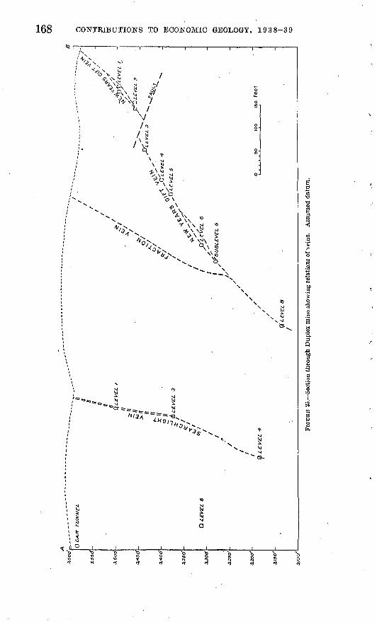
Ci
00
3.10
0"
3J30'
0 C
AR
T
UJV
ME
L.
Q iC
V£i
6
Q L
EV
EL I
\\
- X//
O
/,
^ f
a LE
VE
L
3
«*/
>* If I.
-<0
~ C
SL
EV
EL
5
' ,'£
\ C
fsU
BL
EV
SL
6
I/'
o so
10
0 [s
o Fe
et
FIO
UK
E 25
. Sec
tion
thro
ugh
Dup
lex
min
e sh
owin
g re
latio
ns o
f vei
ns.
Ass
umed
dat
um.
SEARCHLIGHT DISTRICT, CLARK COUNTY, NEVADA 169
obtained from a small ore shoot within the footwall of the vein on level 1.
The inclined shaft on the IXL vein reveals a little quartz-cemented breccia and copper stain, but no ore is known to have been mined from this vein.
The New Years Gift vein was productive from a point a short dis tance above its junction with the Fraction vein to the surface, but most of the stoping appears to have been done on a long, narrow ore body lying mostly between levels 5 and 6. The longitudinal section (fig. 24) indicates a pitch of about 10° E. for this ore body or group of ore bodies. The structure of the vein is complex, and workings reveal intersecting and splitting gouge seams that enclose lenses of country rock and vein matter as much as 15 or 20 feet thick. The ore appears to have occurred in lenses separated by gouge seams or by masses of rock or barren vein material. Some of the stopes are 10 feet or more wide, though the usual width is 4 or 5 feet. The vein material con sists of a breccia of country rock (pi. 44) cemented with quartz, which is generally, stained and partly replaced by copper minerals, chiefly chrysocolla, and iron oxides. Lumps of cerusite and some large bodies of cerusite occurred in this material. A few lumps of coarse galena, are preserved in the ore. All the lead carbonate was valuable ore, but by no, means all the siliceous vein matter was of value. The operators in 1931 stated that good ore, other than lead carbonate ore, could be distinguished by assay only. A thin section of greenish and brownish siliceous ore from a pillar at the Burdick stope, on level 5 revealed numerous minute flakes of gold in quartz or in small areas of limonite.
Weathering of vein material has been complete throughout the mine, except for chunks of galena, one of which was found within a few feet of the surface, in the New Years Gift shaft. A specimen of galena was found by the assayer at the Duplex mill to assay in gold and silver $16.94 a ton (at the old price), and the lead carbonate coating assayed $21.49 a ton. In another specimen the galena assayed $1.03 to the ton, whereas the lead carbonate assayed $69.04 to the ton. Zinc minerals other than films of mottramite were not observed in ore specimens from the Duplex mine, but the zinc reported in smelter returns was probably present in the form of the inconspicuous silicate, hemimorphite (calamine).
A table of smelter returns from photostats in an engineer's report is given below. The ore on which the returns are given was mostly handworked or "chlorided" by lessees. This table does not show the total production of the mine, as considerable ore was milled locally. The figures indicate that shipments containing over 20 percent of lead not only contained more gold than the average of all the shipments, but also a higher proportion of silver to gold and a much lower pro portion of copper.
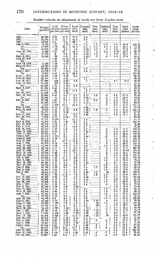
170 CONTRIBUTIONS TO ECONOMIC GEOLOGY, 1938-39
Smelter returns on shipments of crude ore from Duplex mine
Date
1907...............1907..... ..........1907...............July 6, 1915...
Do--.---..Do .........
Aug. 23, 1915 Do
Sept. 8, 1915. July22,1916 ....
Do... . ....... .Aup.29, 1916 ...May 19, 1917
Do... ...-..-June?, 1917. .... ..
Do June ,1917.June 29, 1917 ..July 18, 1917 ...Aug. 12, 1917... ...
Do............Sept. 6,1917
Do. ..Oct. 20,1917 ......Nov. 23, 1917
Do- Feb. 6, 1918. ......
Do ...... .Do ..... ...
Mar. 9, 1918 May 25, 1918... Do ...... . .July 17, 1918 Oct. 30, 1918 .
Do ..Nov. 0,1918 Dec. 23, 1918--. Feb. 4. 1919. Feb. 10.1920......Mar. 15, 1920. .May 11, 1920... June 2, 1920. _ ...June 18. 1920 July 12. 1920 Aug. 7, 1920. Aug. 13, 1920 ...Aug. 26, 1920... ...Aug. 27, 1920 Sept. 15, 1920 .-Sept. 26, 1920 Oct. 2, 1920..Nov. 6,1920 Nov. 18, 1920 Nov. 27, 1'920.Dec. 3, 1920.......Dec. 9, 1920...... Jan. 5, 1921 . .
Do. ......Jan. 17, 1921 Jan. 19, 1921. ..Jan. 28, 1921.....Feb. 1, 1921 .Feb. 9, 1921. ......Feb. 10, 1921___ Mar. 16, 1921......Apr. 7,1921 .
Do .... . Apr. 28, 1921......June4, 1921.-..-Junel7, 1921... Aug. 13, 1021 Sept. 28, 1921 Oct. 1, 1921. .......Nov. 1, 1921.......Nov. 17, 1921..... Dec. 28, 1921...... Feb. 3,1922.. ..Apr. 6, 1922.......JulyS. 1922...
Do July 19, 1922 Sept. 27, 1922 Oct. 26. 1922.......
Weight (pounds)
58, 783 32, 769 14,897 2,532
15, 380 57, 666 4,398
71.7F2 51, 600
3,960 18, 390 45, 658 15, 739 2,670
54, 356 69, 966 67, 866 70, 430 34, 559 34,304 45,011 65, 498 10,980 12, 280 38, 338 36, 292 5,540
89, 332 9,334
51.4F6 37, 946
3, 952 57 953 70J219 69, 539 35, 06862, 9P2 59, 270 60. 720 65, 668 68, 754 75, 836 60, 302 62, 594 68, 754 67, 760 62; 300, 59, 450 66, 936 64, 576> 64, 024 62, ?10 64. 576 63, 440 59, 616 67, 3? 2 68, 220 60, 298 76, 968 61,690 60, 784 87, 404 89, 984 74, 726 77, 722 65, 606 68, 488 60, 836 75. 724 74, 438 67, 724 75, 076 64, 870 69, 618 79, 618 74, 656 64, 044 22, 210 60, 348 81, 234 72. 897
Gold (ounces per ton)
2.31 1.75 2.4 .07
1.49 .54
2.87 .9 .98
1.97 1.31 1.32 1.64 1.94 1.9 3.07 1.48 1.74 .965 .685
1.04 2.45 .93
1.02 2.46
' .21 1.94 2.81 1.705 3.22 4.45 4.08 1.20 4.19 2.P05 5.96 3.38 2.02 4.33 4.68 6.0 5.375 6.19 9.3 6.18 6.49 6.17 5.74 5.68 4.32 7.23 3-35 3.11 4.41 3.35 3.26 6.22 7 58 6.25 4.12 3.56 3.13 3.28 4.14 2.96 5.08 3.43 6.5 3.22 7. 155 4.77 4.P55 4.49 4.205 5.625 3.39 2.96 3.25 2.69 3. 755 6.17 3. 145 1.82
Silver (ounces per ton)
11.8 11.7 6.4 4.31
22.1 4.8
30.7 4.9 6.9
14.43 5.49 6.51 4.3 5.9 5.34
13.33 2.56 2.81 3.66 2.86 2.36 3.41 4.62 2.98 8.6 4.7 2.8 4.1
15.9 5.553.70 3.20 4.5 4.08 6.1 7.07 4.8 7.3 6.0 5.4 6.1 6.4 7.3
10.0 6.8 8.8 7.3 9.3 8.5' 5.6
11.5 8.0 4.4 6.9 8.0 5.2 7.4
11.9 7.8 6.4 5.6 4.1 5.9 7.4 8.0 5.7 6.3 9.4 7.8 7.8 5.7 4.48 6.01 7.03 7.6 4.35 6.25 6.05 7.03 8.9 4.85 7.059 0
Lead (per cent)
27.2 21.6 2,9.7 5.0
35i9 7.5
39.4 8.6 9.6
24.4 5.6 5.0 7.4 5.4 5.6
26.8 6.6
9.8
1.2
II. 8
6.7 8.0 8.0 3.5
58.9
9.8
2.0 7.0
13.4 9'. 2 7.4
14.8 7.2 7.1 9.5 8.5 6.3
13.2 7.8 9.3 8.3
10.4 7.6 7.2 6.9 3.8 2.2 ft. 2 3.8 4.3 4.2 7.9 4.2 7.3 4.5 6.2 2.35 6.5 5.0 7.8 4.0 8.2 7.6 4.8 3.5 4.4 4.65 7.55
11.9 4.65 8.9 7.55 7.4
14.7 6.0 6.95 1.7
Copper (per cent)
2.0 2.4 .3
7.4 4.3 3.82 3.47 2.33 3.43 4.0 4.1 3.7
3.3 2.8
2 1
.7
2 1.6
9 1
5.77 2.23 1.15 2.57 .3
9 09
1.65
2.86
2.4 4.4 2 9 2! 7 2.8 3.35 3.0 3.45 2.7 4.4 3.8 4.3 2.7 4,37 5.5 3.4 6.4 5.0 3.75 4.7 5.0 3.9 5.95 5.5 4.45 2.15 2.4 2.4
2.6 2.9 2.0 3.3 3.0 3.84 2.4 2.3 1.79 3.88 4.23 2.69 3.4 3.47 3.97 3.96 3.89 2.79 3.03 1.7
Zinc (per cent)
1.5 1.2 1.2 .4
1.3 .5
1.8
2.4
1.8
1.5
1.0 1.8
1.05 .62 .55 .7
1.45 .65
1.65
.8
.8
.6
.4
.4
Sulphur (per cent)
0.6 2.8 .6
3.4 .4 .5
.4
.4
.8
.6
.2
.2
.4
.8
.6
.8
.6
.6
.8 1.0 .6 .6 .8 .6
1.0 1.0 .8
.1.0 1.0 1.0 .08
1.0 1.0 1.4 1.4 .6
1.2 1.0 1.0 .8
1.0 .4
1.2 .7.3.7.6 .55
.4
.4
.4
.8
.3
.4
Iron (per cent)
5.5 4.6 3.9 3.78 4.8 4.4
4.1
4.6 5.0 3.4 5.2 3.5 5 5 5.0 5.5 6.4
5.9 6.4 6.3 6.1 5.6 5.4 5.4 5.6 5.6 5.9 5.4 6.4 5.1 5.0 4.1 5.1 5.0 5.0 3.5 5.5 3.5 2.8 2.5 5.5 3.9 3.5 3.4 5.1 4.8 4.5 4.0 3.8 3.7 3.7 2.6 4.6 4.3 4.6 4.5 5.0 5.8 4.6 4.4 4.7 4.8
Insol uble
matter
69.8 38.2 72 2 32.3 69.5 67.8
72.5
67.9 69.4 70.4 76.9 12.4 75.4 67.2 76.5 77.1
71.6 70.0 69.9 69.0 71.7 63.9 69.5 67.6 71.7 58.34 63.5 70.8 65.8 72.2 76.6 39.2 72.2 73.6 68.0 64.8 74.6 70.8 69.8 72.8 70.2 70.8 74.8 73.2 74.0 70.8 71.5 76.8 78.7 79.0 75.2 71.1 66.6 76.4 71.5 71.6 70.0 62.6 74. 8 71.6 78.9
Gross value
per ton
$26. 76 77.29 27.73 98.72 29.11 34.61 77.26 42.71 43.77 41. 32 54.17 51.85
100. 80 36.58 38.88 32.69 15. 14 32.26 52.58 40.97 24.72 76. 24 19.86 47.27 62.55
101.14 73.96
100.15 87.07 35.27 89.22 61.11
140.67 76.89 57.38
102. 32 109. 56 137.30 123.89 136.62 2P9. 14 140. 10 150.93 137. 95 139. 07 136. 30 101. 41 169.12 79.41 67.39 98.70 80.69 71.67
132. 37 164. 14 131.64 89.39 76.76 67.94 72.34 90.70 68.42
169. 00 76.14
138. 90 76.38
147. 22 99.83 08.22 99.08 97.09
125. 57 76.82 70.71 77.22 67.62 96.76
132. 04 76.43 38.42
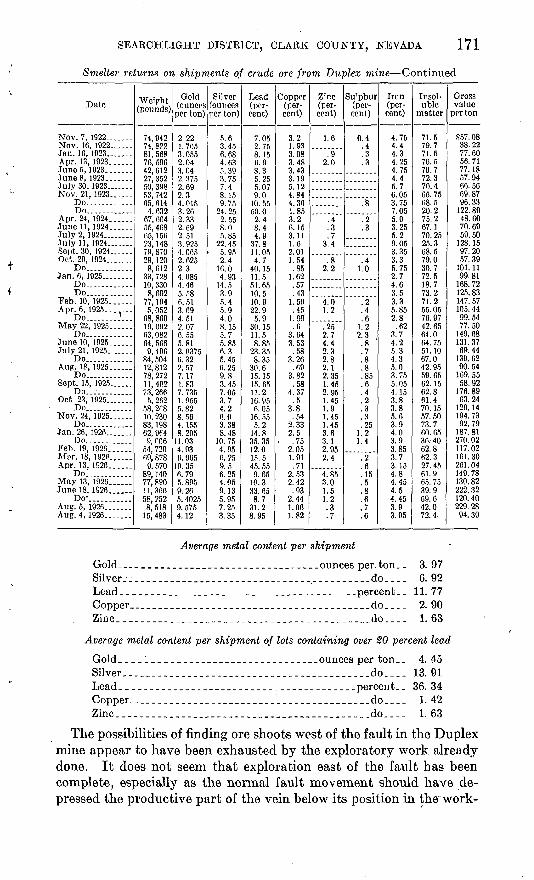
SEARCHLIGHT DISTRICT, CLARK COUNTY, NEVADA 171
Smelter returns on shipments of crude ore from Duplex mine Continued
Dale
Nov. 7,1922.......Nov. 16, 1922......Jan. 16, 1923.......Apr. 13,1923......JuneS, 1923.......JuneS, 1923... ....July 30, 1923.......Nov. 21, 1923......
Do............Do............
Apr. 24, 1924...... June 11, 1924......July 2, 1924........July 11,1924.......Sept. 30, 1924......Oct. 29, 1924.......
Do............Jan. 6, 1925........
Do............Do............
Feb. 10, 1925......Apr. 6, 1925.......
Do....... ?...Mav22, 1925......
Do............June 10, 1925......July 21, 1925.......
Do............ Aug. 18, 1925. ....
Do............Sept. 15, 1925......
Do............Oct 23, 1925.......
Do............Nov. 24, 1925......
Do............Jan. 26, 1926
Do............Feb. 19,1926... ..Mar. 18, 1926. .. Apr. 13, 1926......
Do........ ..May 13, 1926...... June 18, 1926
Do-......" ..Aug. 5, 1926 .Aug. 4, 1926.......
Weight (pounds)
74, 942
81,568
42,61227, 35250. 39853, 742C.K. fil A
4,63267, 664
65,15623,14879, 87029 120
8 H19
33, 72810, 3308, 692
77, 1945, 052
68, 860
64, 5669 dQfi
84, 504 12,8127Q 970
58, 2P8
83, 1S8
54, 72069, S78
9, 57089,14077, 890 11,366 58, 2528,518
15, 483
Gold (ouncos per ton)
2 22
3.0552.043.042. 3752.692.34.0153.262.33 2.692.513.9254.0652 A9S
2 T4.0854.465.586 513 694.512.07fi CC
5.81
6.32 2.577.171 K3
7. 7351.P55c 09
8.564. 1558 9fie
11.034.936.965
10.356.795. 895 9.26 5. 40259. 5754.12
Silver (ounces rer ton)
5.6
6. 684.635.393.757.4
9 7524.252.55
5.8522. 455.952.4
16. 0A QO
14.53 Q5.45 94.0tj 155.75.856.3£.45
9 83.457.053.74.26.03 OQ
8.48
4.956.25 9.56.254.05 9.13 5.957.253.35
Lead (per cent)
7 05
8 1 1\6.98.3
9.0
50.02.4 8.44.9
37.811.054.7
11.551.6510.510 922 9
n Q30.1511.58.85
23 358.35
15.1515.6511.2
6.0516.55
K 9
14.8OK OK
12.015. 5 45. 559.65
10.3 33.65 8.7
31.28 05
Coppor (per cent)
3 9
1.933 f\Q
3.483.433.195.124.84
1.853.2
3.111.62.011.54
OK
1.62.57.43
1.59
1 9<J.6
3 fi4
3.53CO
3.26 .69
3 9.9
.584.37
3.8
2.332.5
.752.051.91 .71
2.532.42 .93
2.441.061.82
Zinc (per cent)
1.6
.92.0
.4
.3
.73.4
2 O
4.01.2
9*9 7
4.42 0
2.8 2.12 OK
1.452 QK
1 451.91.451.453.61 i2.952.4
4.853.0 1.5 1.2.3.7
Sifphur (per cent)
0.4
.3
.20
1.0
.2
.6i 9
0 3
.8 '
.7
.8
.8OK
.6
.4
.2
OK
1.4
.2
.6
.15
.5
.8
.6
.7
.6
Iron (per cent)
4.754.44.34.254.754.45.76.053.757.055.0 3.255.29.053.353.3K. 75
2.74.63.53.35.852.8.62
3.74.25.34.3 5.03 7<i
5.054.153.83.85.63.94.03.93. 853.7 3.154.84.45 4.5 4.453.93.95
Insol uble
matter
71.579.771.570.570.772.370.465.7568.520.275.2 67.170. 2525.368.579.030.7
' 72.518.773.271.255.0576.9742. 6564.064. 7551.1067.0 42.9559.6562.1562.861.470.1557. 5073.760. 6536. 4062.862.3 27.4561.965. 75 39.9 69.642.072.4-
Gross value
per ton
$57. 0838.2277.6056.7177.1857.9466.5669. 8796.33
122. 8048.60 70.6959.50
128. 1597.2057. 39
101.1199.81
168. 72125, 83147. 57105. 4499, 5477.50
149. 68131.3769.44
139.62 90.54
169. 5558.92
176.8963. 24
129.14194.7392.79
187.81270. 02117.02161.30 261.04149.78130.82 222. 32 120. 40229. 2894.39
Average metal content per shipment
Gold________________________________ounces per.ton.. 3. 97Silver ..______________________________________do.__- 6. 92Lead___-_-_________-_____________-_-_---____percent__ 11. 77Copper___-.______.--.___-_.___.._-..____..__.do_.__ 2. 90Zinc..___.._..________._......._...._....___.__do.... 1. 63
Average metal content per shipment of lots containing over 20 percent lead
Gold___-______________________________ounces per ton.. 4. 45Silver __-__--.___.____-__._________-.___...__.__do. 13.91Lead._______________________________________percent__ 36. 34Copper_______________________________.________do.___ 1. 42Zinc_______________________________.___________do____ 1. 63
The possibilities of finding ore shoots west of the fault in the Duplex mine appear to have been exhausted by the exploratory work already done. It does not seem that exploration east of the fault has been complete, especially as the normal fault movement should have de pressed the productive part of the vein below its position in the work-
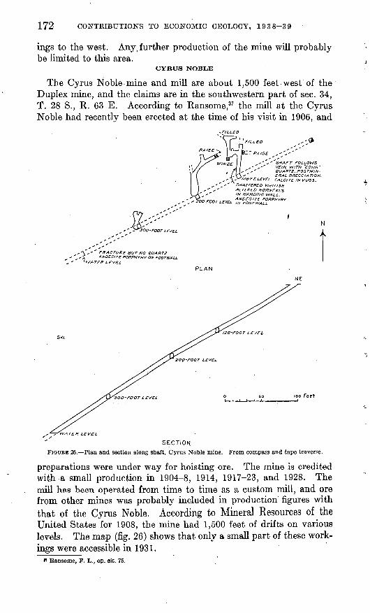
172 CONTRIBUTIONS TO ECONOMIC GEOLOGY, 1938-39
ings to the west. Any\ further production of the mine will probably be limited to this area.
CYRUS NOBLE
The Cyrus Noble mine and mill are about 1,500 feet west of the Duplex mine, and the claims are in the southwestern part of sec. 34, T. 28 S., R. 63 E. According to Ransome,37 the mill at the Cyrus Noble had recently been erected at the time of his visit in 1906, and
« " , ' SHAFT FOLLOWS ",'' VE//V, WITH ~COMB"
QUARTZ. fOSTMIN- , - ERAL BRECCIAT/ON.
'/2B-PT. LEVEL CALCITE/NVUSS.
"SHATTERED WH/T/SH ALTERED HOftfJFELS IN HANGMG WALL
n rnnr , r,,r, A "DESITE PORPHYRY 0-rOOT LEVEL ,H FOOTWALL.
N
A
s ' ' FRACTURE BUT NO QUARTZ, i ANOESITE PORPHYRY ON FOOTWALL \WATER LEVEL
PLAN
SECTION FIGURE 26. Plan and section along shaft, Cyrus Noble mine. From compass and tape traverse.
preparations were under way for hoisting ore. The mine is credited with a small production in 1904-8, 1914, 1917-23, and 1928. The mill has been operated from time to time as a custom mill, and ore from other mines was probably included in production figures with that of the Cyrus Noble. According to Mineral Resources of the United States for 1908, the mine had 1,500 feet of drifts on various levels. The map (fig. 26) shows that only a small part of these work ings were accessible in 1931.
n Ransome, F. L., op. cit. 75.
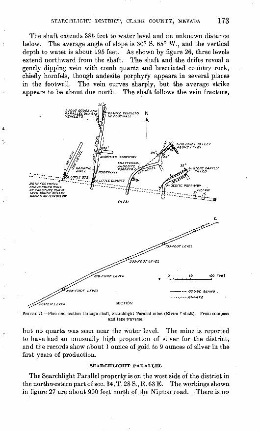
SEARCHLIGHT DISTRICT, CLARK COUNTY, NEVADA 173
The shaft extends 385 feet to water level and an unlmown distance below. The average angle of slope is 30° S. 65° W., and the vertical depth to water is about 195 feet. As shown by figure 26, three levels extend northward from the shaft. The shaft and the drifts reveal a gently dipping vein with comb quartz and brecciated country rock, chiefly hornfels, though andesite porphyry appears in several places in the footwall. The vein curves sharply, but the average strike appears to be about due north. The shaft follows the vein fracture,
~-~----~~~----flr* LITTLE QT2. 11~~~ ~t -f-.-V - - - -- -.. KrA LITTLE QUARTZ
\OTHFOOTWALL ~ ~ ~ ~-~-Jj2~~ ~ ~-~. ,NO HANDING WALL (j~ ~~ ~ ~ ~ ~-~~-~ ~
OF FRACTURE CURVE INTO SOUTH WALLOF SHAFT. NO VEIN BELOW
ANDESITE PORPHYI
'FOOTWALL
SHATi ANDE PORPI-
.NDESITE PORPHYRY
rILL co
PLAN
100 Feet
-- GOUGE: SEAMS
QUARTZ
SECTION
FIGURE 27! Plan and section through shaft, Searchlight Parallel mine (Elvira ? shaft). From compassand tape traverse.
but no quartz was seen near the water level. The mine is reported to have had an unusually high proportion of silver for the district, and the records show about 1 ounce of gold to 9 ounces of silver in the first years of production.
SEARCHLIGHT PARALLEL
The Searchlight Parallel property is on the west side of the district in the northwestern part of sec. 34, T. 28 S., R. 63 E. The workings shown, in figure 27 are about 900 feet north of the Nipton road. ..There is no
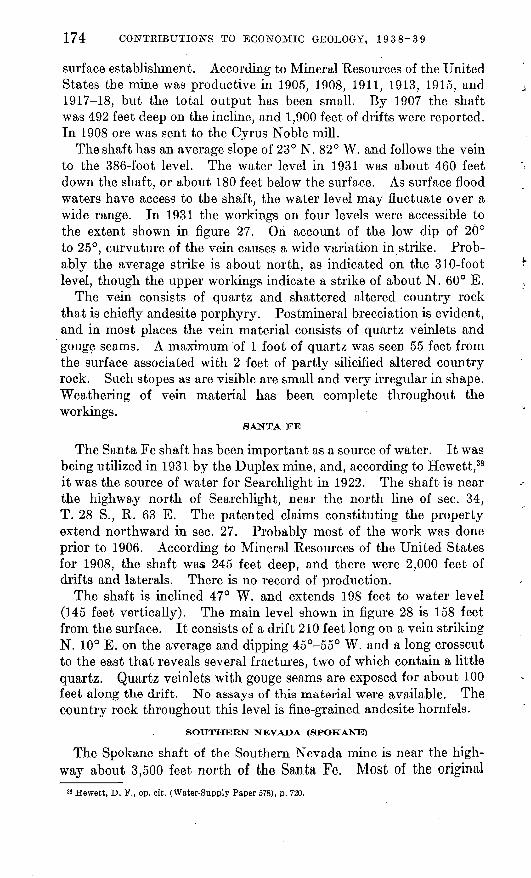
174: CONTRIBUTIONS TO ECONOMIC GEOLOGY, 1938-39
surface establishment. According to Mineral Resources of the United States the mine was productive in 1905, 1908, 1911, 1913, 1915, and 1917-18, but the total output has been small. By 1907 the shaft was 492 feet deep on the incline, and 1,900 feet of drifts were reported. In 1908 ore was sent to the Cyrus Noble mill.
The shaft has an average slope of 23° N. 82° W. and follows the vein to the 386-foot level. The water level in 1931 was about 460 feet down the shaft, or about 180 feet below the surface. As surface flood waters have access to the shaft, the water level may fluctuate over a wide range. In 1931 the workings on four levels were accessible to the extent shown in figure 27. On account of the low dip of 20° to 25°, curvature of the vein causes a wide variation in strike. Prob ably the average strike is about north, as indicated on the 310-foot level, though the upper workings indicate a strike of about N. 60° E.
The vein consists of quartz and shattered altered country rock that is chiefly andesite porphyry. Postmineral brecciation is evident, and in most places the vein material consists of quartz veinlets and gouge seams. A maximum of 1 foot of quartz was seen 55 feet from the surface associated with 2 feet of partly silicified altered country rock. Such stopes as are visible are small and very irregular in shape. Weathering of vein material has been complete throughout the workings.
SANTA FE
The Santa Fe shaft has been important as a source of water. It was being utilized in 1931 by the Duplex mine, and, according to Hewett, 38 it was the source of water for Searchlight in 1922. The shaft is near the highway north of Searchlight, near the north line of sec. 34, T. 28 S., R. 63 E. The patented claims constituting the property extend northward in sec. 27. Probably most of the work was done prior to 1906. According to Mineral Resources of the United States for 1908, the shaft was 245 feet deep, and there were 2,000 feet of drifts and laterals. There is no record of production.
The shaft is inclined 47° W. and extends 198 feet to water level (145 feet vertically). The main level shown in figure 28 is 158 feet from the surface. It consists of a drift 210 feet long on a vein striking N. 10° E. on the average and dipping 45°-55° W. and a long crosscut to the east that reveals several fractures, two of which contain a little quartz. Quartz veinlets with gouge seams are exposed for about 100 feet along the drift. No assays of this material were available. The country rock throughout this level is fine-grained andesite hornfels.
The Spokane shaft of the Southern Nevada mine is near the high way about 3,500 feet north of the Santa Fe. Most of the original
38 Hewett, D. F., op. cit. (Water-Supply Paper 578), p. 720.
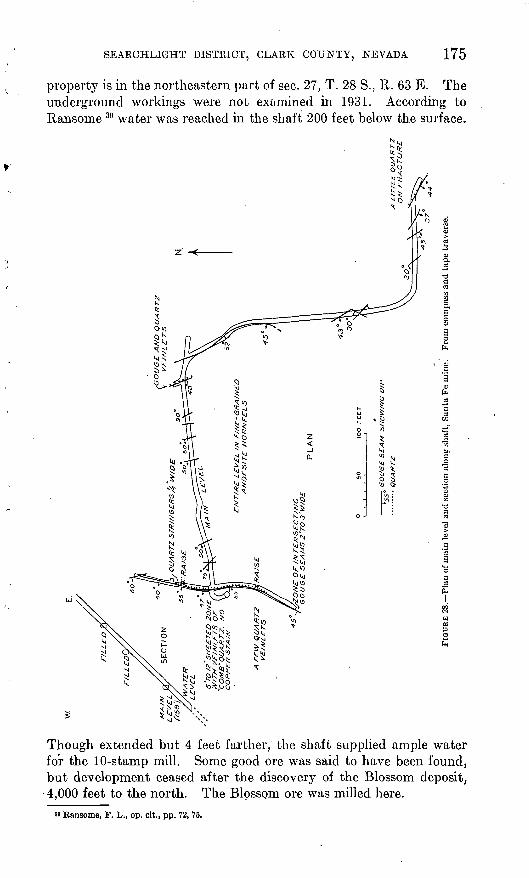
SEARCHLIGHT DISTRICT, CLARK COUNTY, NEVADA 175
property is in the northeastern part of sec. 27, T. 28 S., R. 63 E. The underground workings were not examined in 1931. According to Ransome 39 water was reached in the shaft 200 feet below the surface.
Though extended but 4 feet farther, the shaft supplied ample water for the 10-stamp mill. Some good ore was said to have been found, but development ceased after the discovery of the Blossom deposit, 4,000 feet to the north. The Blossom ore was milled here.
*» Ransome, F. L., op. cit., pp. 72, 75.
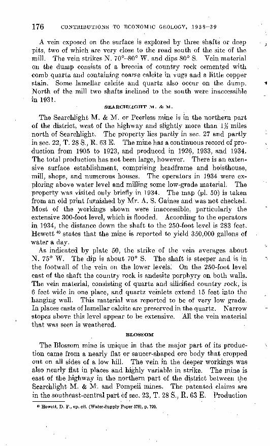
176 CONTEIBUTIOES TO ECONOMIC GEOLOGY, 1938-39
A vein exposed on the surface is explored by three shafts or deep pits, two of which are very close to the road south of the site of the mill. The vein strikes N. 70°-80° W. and dips 80° S. Vein material on the dump consists of a breccia of country rock cemented with comb quartz and containing coarse calcite in vugs and a little copper stain. Some lamellar calcite and quartz also occur on the dump. North of the mill two shafts inclined to the south were inaccessible in 1931.
SEARCHLIGHT M. <fe M.
The Searchlight M. & M. or Peerless mine is in the northern part of the district, west of the highway and slightly more than 1% miles north of Searchlight. The property lies partly in sec. 27 and partly in sec. 22, T. 28 S., R. 63 E. The mine has a continuous record of pro duction from 1905 to 1923, and produced in 1926, 1933, and 1934. The total production has not been large, however. There is an exten sive surface establishment, comprising headframe and hoisthouse, mill, shops, and numerous houses. The operators in 1934 were ex ploring above water level and milling some low-grade material. The property was visited only briefly in 1934. The map (pi. 50) is taken from an old print furnished by Mr. A. S. Gaines and was not checked. Most of the workings shown were inaccessible, particularly the extensive 300-foot level, which is flooded. According to the operators in 1934, the distance down the shaft to the 250-foot level is 283 feet. Hewett 40 states that the mine is reported to yield 350,000 gallons of water a day.
As indicated by plate 50, the strike of the vein averages about N. 75° W. The dip is about 70° S. The shaft is steeper and is in the footwall of the vein on the lower levels. On the 250-foot level east of the shaft the country rock is andesite porphyry on both walls. The vein material, consisting of quartz and silicified country rock, is 6 feet wide in one place, and quartz veinlets extend 15 feet into the hanging wall. This material was reported to be of very low grade. In places casts of lamellar calcite are preserved in the quartz. Narrow stopes above this level appear to be extensive. All the vein material that was seen is weathered.
BLiOSSOM
The Blossom mine is unique in that the major part of its produc tion came from a nearly flat or saucer-shaped ore body that cropped out on all sides of a low hill. The vein in the deeper workings was also nearly flat in places and highly variable in strike. The mine is east of the highway in the northern part of the district between the Searchlight M. & M. and Pompeii mines. The patented claims are in the southeast-central part of sec. 23, T. 28 S., R. 63 E. Production
« Hewett, D. F., op. cit. (Water-Supply Paper 678), p. 720.
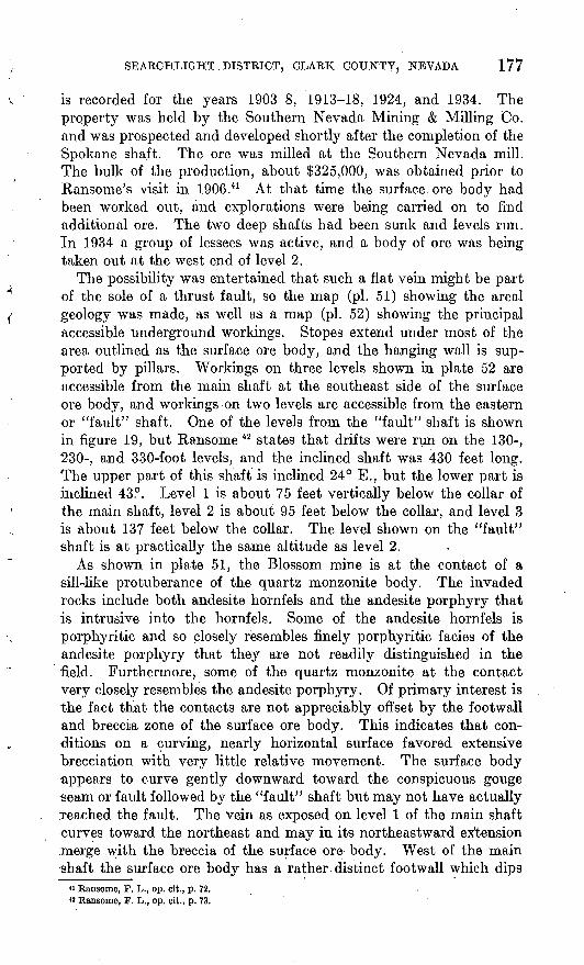
SEARCHLIGHT . DISTRICT, CLARK COUNTY, NEVADA 177
is recorded for the years 1903-8, 1913-18, 1924, and 1934. The property was held by the Southern Nevada Mining.& Milling Co. and was prospected and developed shortly after the completion of the Spokane shaft. The ore was milled at the Southern Nevada mill. The bulk of the production, about $325,000, was obtained prior to Ransome's visit in 1906.41 At that time the surface, ore body had been worked out, and explorations were being carried on to find additional ore. The two deep shafts had been sunk and levels run. In 1934 a group of lessees was active, and a body of ore was being taken out at the west end of level 2.
The possibility was entertained that such a flat vein might be part of the sole of a thrust fault, so the map (pi. 51) showing the areal geology was made, as well as a map (pi. 52) showing the principal accessible underground workings. Stopes extend under most of the area outlined as the surface ore body, and the hanging wall is sup ported by pillars. Workings on three levels shown in plate 52 are accessible from the mam shaft at the southeast side of the surface ore body, and workings on two levels are accessible from the eastern or "fault" shaft. One of the levels from the "fault" shaft is shown in figure 19, but Ransome 42 states that drifts were run on the 130-, 230-, and 330-foot levels, and the inclined shaft was 430 feet long. The upper part of this shaft is inclined 24° E., but the lower part is inclined 43°. Level 1 is about 75 feet vertically below the collar of the main shaft, level 2 is about 95 feet below the collar, and level 3 is about 137 feet below the collar. The level shown on the "fault" shaft is at practically the same altitude as level 2.
As shown in plate 51, the Blossom mine is at the contact of a sill-like protuberance of the quartz monzonite body. The invaded rocks include both andesite hornfels and the andesite porphyry that is intrusive into the hornfels. Some of the andesite hornfels is porphyritic and so closely resembles finely porphyritic facies of the andesite porphyry that they are not readily distinguished in the field. Furthermore, some of the quartz monzonite at the contact very closely resembles the andesite porphyry. Of primary interest is the fact that the contacts are not appreciably offset by the footwall and breccia zone of the surface ore body. This indicates that con ditions on a curving, nearly horizontal surface favored extensive hrecciation with very little relative movement. The surface body appears to curve gently downward toward the conspicuous gouge seam or fault followed by the "fault" shaft but may not have actually reached the fault. The vein as exposed on level 1 of the main shaft curves toward the northeast and may in its northeastward extension merge with the breccia of the surface ore body. West of the main shaft the surface ore body has a rather distinct footwall which dips
« Ransome, F. L., op. cit., p. 72. « Ransome, F. L., op. cit., p. 73.
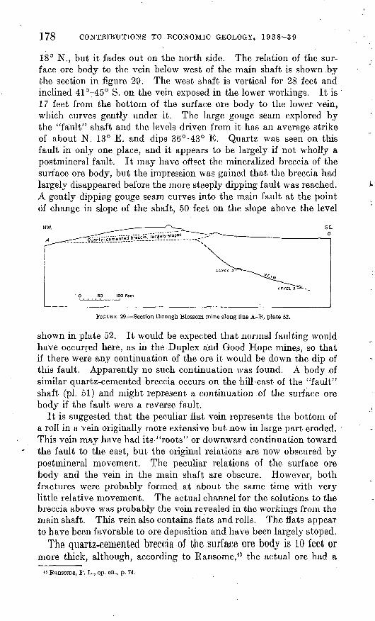
178 CONTRIBUTIONS TO ECONOMIC GEOLOGY, 1938-39
18° N., but it fades out on the north side. The relation of the sur face ore body to the vein below west of the main shaft is shown by the section in figure 29. The west shaft is vertical for 23 feet and inclined 41°-45° S. on the vein exposed in the lower workings. It is 17 feet from the bottom of the surface ore body to the lower vein, which curves gently under it. The large gouge seam explored by the "fault" shaft and the levels driven from it has an average strike of about N. 13° E. and dips 36°-43° E. Quartz was seen on this fault in only one place, and it appears to be largely if not wholly a postmineral fault. It may have offset the mineralized breccia of the surface ore body, but the impression was gained that the breccia had largely disappeared before the more steeply dipping fault was reached. A gently dipping gouge seam curves into the main fault at the point of change in slope of the shaft, 50 feet on the slope above the level
SEL
FIGURE 29. Section through Blossom mine along line A-B, plate 52.
shown in plate 52. It would be expected that normal faulting would have occurred here, as in the Duplex and Good Hope mines, so that if there were any continuation of the ore it would be down the dip of this fault. Apparently no such, continuation was found. A body of similar quartz-cemented breccia occurs on the hill east of the "fault" shaft (pi. 51) and might represent a continuation of the surface ore body if the fault were a reverse fault.
It is suggested that the peculiar fiat vein represents the bottom of a roll in a vein originally more extensive but now in large part eroded. This vein may have had its-'"roots" or downward continuation toward the fault to the east, but the original relations are now obscured by postmineral movement. The peculiar relations of the surface ore body and the vein in the main shaft are obscure. However, both fractures were probably formed at about the same time with very little relative movement. The actual channel for the solutions to the breccia above was probably the vein revealed in the workings from the main shaft. This vein also contains flats and rolls. The flats appear to have been favorable to ore deposition and have been largely stoped.
The quartz-cemented breccia of the .surface ore body is 10 feet or more thick, although, according to Ransome,43 the actual ore had a
« Ransome, F. L., op. cit., p. 74.
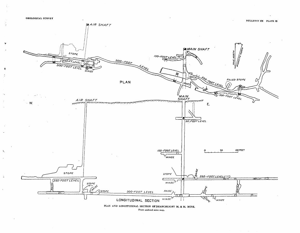
GEOLOGICAL SURVEY
SHAFTBULLETIN 906 PLATE 50
LONGITUD^NAL SECTION WINZE
PLAN AND LONGITUDINAL SECTION OF [SEARCHLIGHT M. & M. MINE.
From undated mine map.
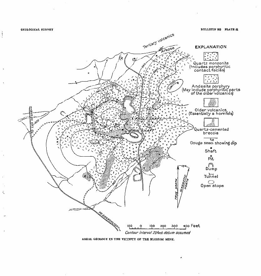
GEOLOGICAL SURVEY BULLETIN 006 PLATE 61
EXPLANATION
Andesite porphyry ii i i i «*y* ^yay include porphyritic parts
of the older volcamcs)
Older volcanics< (Essentially a hornfels)
Quartz-cemented breccia
Gouge seam showing dip
NORTH
&Jj>
fc
/(S-e^
4
Wjkv/^$* 37/
/
ShaftX
Pitf''*
Dump
Tunnel
O Open stope
200 300 400 Feet
Contour interval 30feet; datum assumed
AREAL GEOLOGY IN THE VICINITY OF THE BLOSSOM MINE.
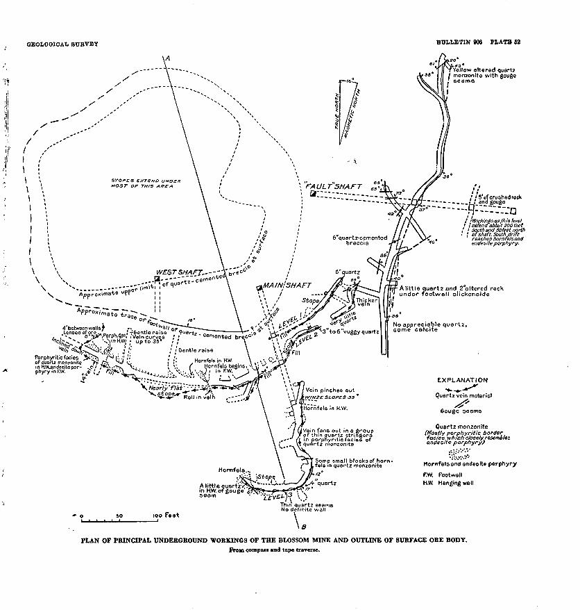
GEOLOGICAL SURVEY BULLETIN 906 PLATE) 62
Yellow altered quart; monzonite with gouge seams
MAIN; SHAFT
'£
,-V$ ^*3L *"<** »* U-VVx:^^»3"to6"vuggy quartz
cemented brec<>* J>^./^el 9' \\ f'^y
mH.W,andesitepor- .c ' phyryinF.W. ^
\ \: f Hornfels begins, v
'' flai' "i.Tit-J^
^Jg-*" "ROI| ; n vei'n ""J.'H
too Feet
Vein pinches outy.'f/£ SLOPES 3S '
Hornfels in H.W.
Vein fans out in a group of thin quartz stringers
'I m porphyritic facies ofj quartz monzonite
Some small blocks of horn- fels in quartz monzonite
! ' 5 of crushed rock ' and gouge
this leveli I eii'tena about SOO feet I < south and 50 feet north ! of shaft. South drift
reaches thornfe/sand endesite porphyry.
A little quartz and 2"altered rock under footwall slickenslde
No appreciable quartz, some calcite
EXPLANATION^ *"
Quartz vein materiel
6ouge seems
Quartz monzonite (Mostly porphyritic border facies which closely resembles andesite porphyry}
Hornfels end ende<* porphyry
F.W. Footwall H.W. Hanging wall
PLAN OF PRINCIPAL UNDERGROUND WORKINGS OF THE BLOSSOM MINE AND OUTLINE OF SURFACE ORE BODY.From compass and tape traverse.
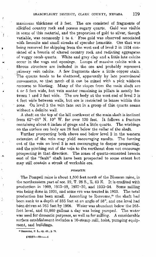
SEARCHLIGHT DISTRICT, CLARK COUNTY, NEVADA 179
maximum thickness of 3 feet. The ore consisted of fragments of silicified country rock and porous sugary quartz. Gold was visible in some of this material, and the proportion of gold to silver, though variable, was commonly 1 to 4. Free gold was observed associated with limonite and small streaks of specular hematite. Ore that was being removed for shipping from the west end of level 2 in 1934 con sisted of a breccia of altered country rock and radiating aggregates of Vuggy comb quartz. White and gray clay and a little late calcite occur in the vugs and openings. Lumps of massive calcite with a fibrous structure are included in the ore and probably represent primary vein calcite. A few fragments show a little copper stain. The quartz tends to be shattered, apparently by late postmineral movements, so that much of it can be mined with a pick without recourse to blasting. Many of the stopes from the main shaft are 4 or 5 feet wide, but vein matter remaining in pillars is mostly be tween 1 and 2 feet wide. The ore body at the west end of level 2 is 4 feet wide between walls, but ore is restricted to lenses within this zone. On level 3 the vein fans out in a group of thin quartz seams without a definite wall.
A shaft on the top of the hill northwest of the main shaft is inclined from 62°-66° N. 10° W. for over 120 feet. It follows a fracture containing about 6 inches of gouge and a little quartz. The Workings on the surface ore body are 28 feet below the collar of the shaft.
Further prospecting both above and below level 2 in the western extension of the vein may yield encouraging results. The fanning out of the vein on level 3 is not encouraging to deeper prospecting, and the pinching out of the vein to the northeast does not encourage prospecting in that direction. The zones of quartz-cemented breccia east of the "fault" shaft have been prospected to some extent but may still contain a streak of workable ore.
POMPEII
The Pompeii mine is about 1,500 feet north of the Blossom mine, in the northeastern part of sec. 22, T. 28 S., R. 63 E. It is credited with production in 1909, 1913-18, 1927-30, and 1933-34. Some milling was being done in 1931, and some ore was treated in 1933. The total production has been small. According to Raneome,44 the shaft had been sunk to a depth of 335 feet at an angle of 58°, and one level had been driven at 265 feet by 1906. Water was abundant below the 265- foot level, and 65,000 gallons a day was being pumped. The water was used for domestic purposes, as well as for milling. A considerable surface establishment includes a 10-stamp mill, hoist, pumping equip ment, and buildings.
44 Ransome, F. L., op. cit., p. 74.
136973 39 4
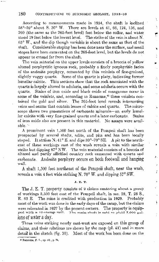
180 CONTRIBUTIONS TO ECONOMIC GEOLOGY, 1938-39
According to measurements made in 1934, the shaft is inclined 58°-59° about S. 30° W. There are levels at 41, 66, 124, 156, and 260 (the same as the 265-foot level) feet below the collar, and water stood 19 feet below the lowest level. The strike of the vein is about N. 65° W., and the dip though variable is about the same as that of the shaft. Considerable stoping has been done near the surface, and small stopes have been excavated on the 265-foot level, but the levels do not appear to extend far from the shaft.
The vein material on the upper levels consists of a breccia of yellow altered porphyritic igneous rock, probably a finely porphyritic facies of the andesite porphyry, cemented by thin veinlets of fine-grained, slightly vuggy quartz. Some of the quartz is platy, indicating former lamellar calcite. Thin sections show that the rock associated with the quartz is largely altered to adularia, and some adularia occurs with the quartz. Stains of iron oxide and black oxide of manganese occur in some of the veinlets, and, according to Ransome,45 these veinlets con tained the gold and silver. The 265-foot level reveals intersecting veins and seams that contain lenses of calcite and quartz. The micro scope shows two generations of carbonate minerals an early lamel lar calcite with very fine-grained quartz and a later carbonate. Stains of iron oxide also are present in this material. No assays were avail able. '
A prominent vein 1,50.0 feet north of the Pompeii shaft has been prospected by several shafts, adits, and pits and has been locally stoped. It strikes N. 41° E. and dips 30°-70° SE. A pit to the north east of these workings east of the wash reveals a vein with similar strike but dipping 87° NW. The vein material consists of a breccia of altered and partly silicified country rock cemented with quartz andcarbonate. Andesite porphyry occurs on both footwall and hangingwall.
A shaft 1,500 feet northeast of the Pompeii shaft, near the wash, reveals a vein 4 feet wide striking N. 70° W. and dipping 57° SW.
J. E. T.
The J. E. T. property consists of 9 claims centering about a group of workings 3,500 feet east of the Pompeii shaft, in sec. 28, T. 28 S., R. 63 E. The mine is credited with production in 1929. Probably most of the work was done in the early days of the camp, but the claimswere relocated in 1927 by the present owners. The property is equip ped. With, a lO-Stamp mill. Xlie main, slio/ft is said to yield 7,OOO gal-
Ions of water a day,Three veins striking nearly east-west are exposed on this group of
claims, and their relations are shown by the map (pi. 41) and in more detail in the sketch (fig. 30). Most of the work has been done on the
11 Ransome, F. L., op. cit., p. 74.
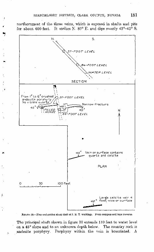
SEARCHLIGHT DISTRICT, CLARK COUNTY, NEVADA 181
northernmost of the three veins, which is exposed in shafts and pits for about 600 feet. It strikes N. 80° E. and dips mostly 43°-45° S-.
37-FOOT' LEVEL
Q4-FOOT LEVEL
WATER LEVEL
SECTION
From I "to 6"crushed andesite porphyry No visible quartz
\ \ \ \
37-FOOT .LEVEL
Narrow fracture
Vein on surface contains quartz and calcite
PLAN
50'100 Feet
Large calcite vein 4 feet wide on surface
FIGURE 30. Plan and section along shaft of J. E. T. workings. From compass and tape traverse.
The principal shaft shown in figure 30 extends 110 feet to water level on a 45° slope and to an unknown depth below. The country rock is andesite porphyry. Porphyry within the vein is brecciated. A
182 CONTRIBUTIONS TO ECONOMIC GEOLOGY, 1938-39
very little quartz and some calcite appear in the vein. Some small spots are reported to have yielded high assays, but most of the assays recorded are low (0.1-0.4 ounce of gold to the ton). According to an engineer's report, assays revealed no gold below a depth of 90 feet in the shaft.
Two carbonate veins dipping 40°-45° N. and striking nearly east lie 180 and 300 feet south of the main vein. The southern vein is particularly prominent and is exposed for 1,000 feet. The carbonate vein in many places is 4 feet wide and contains coarse calcite, greenish
Closely jointed quartz monzonite with open fractures.Some clear calcite. No visible ore minerals
A little vein matter, brecciated with the country rock
FiQUKE 31. Plan and section along shaft, Berlock workings. From compass and tape traverse.
or whitish clay, and very fine-grained quartz. Quartz in some of thematerial appears to have been brecciated and cemented with pinkish calcite. This material is reported to assay only a trace of gold.
It appears that the chief hope for production lies in the discovery of pockets or small bodies of gold ore sufficiently rich to mine, which maybe found on the southward-dipping vein.
OTHEB MINES AND PROSPECTS IN THE MAIN PART OF THEDISTRICT
A shaft known as the Berlock, 2,200 feet northeast of the Ramblerworkings, on the pediment slope east of the ridge, extends 83 feetdown to a level (fig. 31) which is close to the contact of the quartz
monzonite and a loose shattered breccia of andesite porphyry. Alittle quartz-vein material was found in the brecciated andesite
porphyry. No production is known to have been obtained.
SEARCHLIGHT DISTRICT, CLARK COUNTY, NEVADA -183
A shaft 1,400 feet east-northeast of the Good Hope shaft exposes a vertical vein 2 feet wide striking N. 15° E.
A vein 1,000 feet southeast of the Fraction shaft of the Duplex mine, as revealed by a shaft and pits, strikes N. 58° W. and dips 58° SW. at the shaft. No ore was found.
A group of shafts in quartz monzonite 1,400 feet east-northeast of the vein last described were sunk on stringers of quartz with a little copper stain trending nearly east-west and dipping 40°-70° S.
A shaft at the quartz monzonite contact 1,100 feet east-northeast of the Fraction shaft of the Duplex mine reveals a vein trending N. 80° E. and dipping 60° S. A little vuggy quartz occurs in both the quartz monzonite and the intruded hornfels.
Two nearly parallel breccia zones trending N. 78° W. and dipping 68° SW. are exposed by pits and an adit on the north side of the lull in the western part of Searchlight, near the highway.
A shaft 1,000 feet southeast of the Southern Nevada mine is inclined 75° S. 15° W. at the top. Material on the dump contains breccia with quartz veinlets and copper stain.
A shaft 1,000 feet west of the Searchlight M. & M. mine extends 173 feet to a crosscut and 40 feet farther to the bottom. The cross cut was driven 400 feet N. 14° E. in yellowish altered andesite por phyry. The Searchlight M. & M. vein, which it apparently was designed to intersect, was not found.' The depth from surface to bed rock in this shaft is 120 feet.
Another shaft 700 feet southwest of that last described is 205 feet deep and is in alluvium throughout. A drift 33 feet to the east cuts bedrock of andesite porphyry. The bedrock surface slopes steeply to the west. Shafts farther west show yellowish altered porphyritic andesite, and those farthest to the west expose red porphyritic andes ite, which probably belongs to the later group of volcanic rocks.
A shaft at the west side of the highway 1,000 feet north of the Searchlight M. & M. mine explores a vein containing as much as 8 inches of quartz which strikes N. 80° E. and dips 70° S. Another vein 400 feet southeast of this one strikes N. 80° E. and is explored by three vertical shafts and several.pits.
MINES AND PROSPECTS IN THE EASTERN PART OF THE DISTRICT
The mines and prospects in the eastern part of the Searchlight dis trict are not shown on plate 41 and were visited only briefly. The Boston mine in this area was not seen.
BOSTON
The Boston claims are about 1% miles northeast of Searchlight on the line between sees. 25 and 26, T. 18 S., R. 63 E., and were among
184- CONTRIBUTIONS TO ECONOMIC GEOLOGY, 1938-39
the earliest to be prospected in the district. The following descrip tion is quoted from Ransome's report: 46
The Boston group of the Quartette Mining Co. was extensively prospected some years ago, but the attempt to find workable ore bodies was unsuccessful. There are two shafts on the property, an incline about 300 feet deep and a well- constructed vertical shaft 400 feet deep. Both are now (1906) dismantled. The workings are close to the eastern border of the quartz monzonite, in much shat tered and greatly altered andesitic porphyry, which breaks readily into small dark- green or dark-red fragments and contains seams of epidote. The vein does not outcrop distinctly but apparently strikes nearly east and west. Some small bunches of good ore were found, consisting of chalcocite, malachite, azurite, chryso- colla, and cerusite, but an average value of about $6 per ton was the best that could be obtained for any considerable part of the deposit.
VIRGINIAN
The Virginian prospect is a short distance north of the Kingman Ferry road 2.1 miles east of Searchlight. A vein trending about N. 80° E. and dipping about 60° S. is prospected for a length of 400 feet by pits and shallow shafts. Some additional workings are offset from each end of the vein. The country rock is andesite porphyry. The vein material consists of quartz and fragments of country rock mostly less than 1 foot wide.
CHIEF OF THE HILLS
The Chief of the Hills mine is on a ridge known as Fourth of July Mountain, south the Kingman Ferry road 3 miles east of Searchlight. It was one of the properties of the Quartette Mining Co., and was oper ated for several years by lessees. Production is recorded for the years 1909-12; when ore was sent to the Cyrus Noble mill, 1917-19 and 1922-23, when it was operated by the Biverview Gold Mining & Milling Co. The total production has not been large. A mill and other buildings in apparent good condition stand on the west slope of the ridge.
The Vein Strikes about N. 85° W., or nearly at right angles to theridge, so that the vein has been developed by adits rather than shafts.The lower drift is reached by a crosscut at the mill level, which was not accessible to the writer in 1931. An upper adit 93 feet long followsthe vein, which has been stoped both above and below, it the nextlevel above a caved stope slopes 76° N. A vein diverging slightly
from the main vein on tie south interescts it on the top of the ridge.The country rock is all andesite porphyry, which is epidotized in a
broad zone paralleling the vein. The vein material as shown in one of the adits consists of brecciated andesite porphyry cemented with
vuggy comb quartz. Cavities are partly filled with gray calcite,which in some places has an orange cast. "Some manganese stain indicates that the calcite is manganiferous. No assays of this ma terial were available.
«Bansome, F. L., op. cit., p. 72.
SEAKCHLIGHT DISTRICT, CLAKK COUNTY, NEVADA 185
BIG CASINO
The Big Casino mine is south of the Kingman Ferry road about 3% miles east of Searchlight. Production is recorded for 1913, 1915- 16, 1918-21, and 1931-33. Copper and lead as well as gold and silver were produced. In 1931 the mine had been relocated as the Monte Carlo, and some work was being done on the surf ace north of the main shaft. Underground workings were wholly inaccessible. The main shaft is inclined 60° S. 40° W. in the upper part. The country rock is chiefly andesite porphyry. A cut south of the shaft exposed a vein containing quartz stringers trending due west and dipping 60° S. Another vein containing 1 foot of porous quartz strikes N. 65° W. and dips 40° SW. A vein near the cabin strikes N. 40° W. and dips 54° SW.
A pile of unweathered ore on the dump from the main shaft con tains fragments of partly silicified country rock with scattered grains of galena, chalcopyrite, and sphalerite in quartz. According to a statement by the operators,47 concentrates contained 4.2 ounces of gold and 12.1 ounces of silver to the ton, 17.9 percent of lead, 5.5 per cent of copper, and 19.4 percent of zinc.
NEW ERA
The six claims constituting the New Era property are near the King man Ferry road 5.2 miles east of Searchlight. A small production is recorded for 1922, 1925, and 1931-34. The north shaft exposed a vein in andesite porphyry trending N. 45° W. and dipping 65° SW. The vein material is thoroughly weathered and consists of brecciated country rock and quartz without well-defined walls. The main shaft is inclined 65° N. 65° E. and is said to be 240 feet feep, with water level 200 feet below the surface.
» Weed, W. H., Mines Handbook, vol. 15, p. 1145,1922.
INDEX
Page Abstract.... 135-136Accessibility of the district.. .. 139 Acknowledgments for aid_............... 136-137Andesite porphyry, age of.... .. - 141
character and occurrence of- - 143-144, pis. 41,42
Berlock shaft, features of..---------- -.-. 182Bibliography......... ... 137-139Big Casino mine, description of....__ 152,153,185Blossom mine, areal geology in vicinity of- pi. 51
description of..-------.-------.--. 176-179,pi. 52Boston mine, description of.- - 183-184
Chalcedony, occurrence of. ------------ ... 153Chalcocite, occurrence of _.... . 152,153Chalcopyrite, occurrence of. ------- _ - - 152,153,185Chief of the Bills mine, description of-... - 184 Climate of the district........1... ... 140Copper, production of. _.___ . _. 151-
152,153,154,161,165,170-171,185Copper King claim, outcrop on.... -.. _ ... 161Cuprite, occurrence of._.____---------- 153Cyrus Noble mine, description of___ 172-173
Dikes, character and occurrence of 145, pi. 41Duplex mine, description of... . 151,
154,160,165-172, pi. 44smelter returns on ore from._.- .__ 169-171 workings of-.---.----------.----- 165-167, pi. 49
Duplex Mining Co., operations by.---------- 165
Field work, account of_. . __.... 136 Fraction vein, strike and dip of- ____.... 167
Galena, occurrence of.. ...... 152,153,167,169,185Geography of the district.... ... 139-140Geologic history, summary of_.. _.. _. 147-149 Geology of the district.--.......-. 140-147, pis. 41,51Gneiss, age of-_..______ . 141
character and occurrence of....... 142, pis. 41,42Gold, production of-___ .-. .... 151-
152,153,161,165,170-171,173,182,185 Golden Treasure claim, outcrop on.....___ 161Good Hope mine, description of-------------- 161-
152,164-165, pis. 47,48
Hematite, occurrence of....... _. ... 153,179Homestead Mining & Milling Co., operations
by. 165Hornfels, character and occurrence of..__ 142-143,
pis. 43,44
IXL vein, strike and dip of... 167
J. E. T. mine, description of _ 180-182
PageLead, production of... _-....-...-...-.....- 151-152,
153,154,161,165,170-171,185Location of the district.. 137,139
Malachite, occurrence of___.-.....--... 153Metals, production of... ..........___ 150-153,
161,165,170-171,182,185 Mineral deposits, areal zones of.. ....._ 158-159
character of........_----- -... 151-154classification of-- ---_.............. 154-155See also individual mines.
Mines, miscellaneous, features of........... 182-183See also individual mines.
Mining, future of.__..__.__..._-... 159-161history of. _..._---------- 149-151
Mollin Investment Co., operations by____ 150 Monte Carlo mine. See Big Casino mine. Mottraraite, occurrence of__......_.. 153
New Era mine, features of..._..-__.._. 185New Years Gift vein, strike and dip of..._ 167
workings on........................ 165-166,169
Ore, classification of.. ___. _..... ___ 154-155minerals in........___________ 152-154production of_______....___._ . 151See also individual mines.
Outlook for the district.... __.... 159-161
Peerless mine, description of ..___. __ 176 Phoenix mine. See Good Hope mine. Pompeii mine, features of. __________ 179-180 Population of the district .. 139,150 Pre-Cambrian rocks, occurrence of __ 141,142 Precipitation in the district__......__.- 140Production, costs of-- _ 160,163-164
history of 136,149-151Prospects, miscellaneous, features of....._ 182-183
Quartette mine, description of.____ 150-151,152,153-154,160,161-164, pis. 45,46
Quartette Mining Co., operations by.__.. 150,184Quartz monzonite, age of._________. 141
character and occurrence of___ 144-145, pi. 41structure of__.______. ____ 146-147
Rambler claim, outcrop on.................... 161Rambler vein, features of___________ 155 Ransome, F. L., quoted.________..... 163Riverview Gold Mining & Milling Co., opera
tions by___....._.__..._ 184Rocks of the district, age of._..._ _.... 141
alteration of 157-158character and distribution of. 140-146, pis. 41-44 correlations of.. ___. _______.. 148-149
187
188 IlNDEX
Santa Fe shaft, features of------------------ 174,175Searchlight, population of-... __. _... _ 139,150 Searchlight Gold Corporation, operations by 150,165 Searchlight M. & M. mine, description of- 176, pi. 50 Searchlight Mercantile Co., operations by.... 150Searchlight Parallel mine, description of. 152,173-174 Searchlight vein, strike and dip of--------- _ 167Silver, production of....................... 151-152,
153,161,165,170-171,182,185Southern Nevada mine, description of-.--.. 174-176 Southern Nevada Mining & Milling Co.,
operations by_..........._..... 177Sphalerite, occurrence of_............. 152,153,185Spokane shaft. See Southern Nevada mine. Structure of the district..--..__....... 146-147
Page Tertiary rocks, occurrence of__.--... 141,148-149Topography of the district ...._.__... 139-140
Vanadinite, occurrence of_------------------ 153Vegetation in the district...-___......_. 140Veins, classification of---------------------- 154-155
minerals in..-_,........................ 151-154structure of .-.---..-...--....-.-.--.. 155-157
Virginia prospect, features of................. 184Volcanic rocks, aseof-.-_.........._ 141,148-149
character and distribution of........... 142-143,145-146, pis. 41,43,44
Water, availability of, for milling.-.-.-.-... 140,160 Wulfenite, occurrence of. ------------- _. -. 153,154
Temperature in the district___...__. 140 Zinc, occurrence of .._.-.-_-.-.-... 170-171,185
o