geology of the nyeri area - s3-eu-west-1.amazonaws.comof+the+nyeri+area+2.pdf · geology of the...
TRANSCRIPT

Report No. 12
MINISTRY OF ENVIRONMENT AND NATURAL RESOURCES
MINES AND GEOLOGICAL DEPARTMENT
GEOLOGY OF THE NYERI AREA (with colored geological map)
by
R.M. Shackleton, B.Sc. Ph.D., F.G.S. Geologist
First print 1945 Reprint 2007
Report No. 12
MINISTRY OF ENVIRONMENT AND NATURAL RESOURCES
MINES AND GEOLOGICAL DEPARTMENT
GEOLOGY OF THE NYERI AREA (with colored geological map)
by
R.M. Shackleton, B.Sc. Ph.D., F.G.S. Geologist
First print 1945 Reprint 2007
Report No. 12
MINISTRY OF ENVIRONMENT AND NATURAL RESOURCES
MINES AND GEOLOGICAL DEPARTMENT
GEOLOGY OF THE NYERI AREA(with colored geological map)
by
RM. Shackleton, B.Sc. Ph.D., F.G.S. Geologist
First print 1945Reprint 2007

GEOLOGY OF THE NYERI AREA (with colored geological map)
by
R.M. Shackleton, B.Sc. Ph.D., F.G.S. Geologist
First print 1945 Reprint 2007
GEOLOGY OF THE NYERI AREA (with colored geological map)
by
R.M. Shackleton, B.Sc. Ph.D., F.G.S. Geologist
First print 1945 Reprint 2007
GEOLOGY OF THE NYERI AREA(with colored geological map)
by
RM. Shackleton, B.Sc. Ph.D., F.G.S. Geologist
First print 1945Reprint 2007

‘ CONTENTS4 on
_.I
l‘JNTRODUCTlON . .ll—PREVIOUS GEOLOGICAL WORK ..
ill—SUMMARY OF THE GEOLOGICAL SUCCESSIONIV—CORRELATION WITH OTHER AREAS ..V—PHYSICAL AND GENERAL GEOLOGY
(I) The Kinangop Plateau(2) The CI Bolossat Plain(3) Kipipiri
_(_4_) The Sattima Fault Scarp'(5) The Northern Aberdare Ramp ..(6) Simbara(7) Gusiru . .(8) The AbeIdare Dip--slope ..(9) Southern Laikipia
Vl—PETROGRAPHYVII—STRUCTURE
VIII—ECONOMIC GEOLOGY
RAGE ' '
MO
OQ
VqflfiN
—h
h—
N___..
_I—
NW
NNfl—
W
lX—WATER SUPPLY GEOLOGY 0F TIIE AREA BETWEEN MT. l<ENYA AND THEABERDARE RANGE
X—REEERENCES
ILLUS'! RATIONsFig. l—Geological Sketch-map show ng Mt Kenya and the
Aberdare Range .. .Fig. 2——Geological Section from Sattima to Mt. Kenya.Pl. I——-(a) View northwards along the Sattima Fault Scarp. (b) Part
of the Sattima Scarp. showing the feature due to theeastern fault .. .
Pl. lI—A—(a) Flags of porphyrilic qIIIIrtz--Ir:Ichytc (Snttimzi Series) northoi Sattima. (b) View northwards up the Honi Valley toSattima, showing supposed solifluxion deposit
2326
Facing p. 2i 20
Facing p. 8
Facing p. 9Provisional Geological Map of the Nyeri District .. .. In end folder
GEOLOGY OF THE NYERI AREA ,I—INTRODUCTION
A rapid geological survey of the district around Nyeri was carried out early inI945, partly in order to determine whether the geological structure between Mt. Kenyaand the Aberdare Range was such (hat artesian water was likely to occur there. Thisreport deals with the geology of the Nyeri quarter-degree sheet, which was surveyed inmore detail than the surrounding areas: The limits of the sheet are the equator, 0° 30’ S.,36° 30’ E., and 37° 30’ E.; it has an area of a little less than l,200 square miles. Elevenweeks were spent in field work in this area; reconnaissance traverses were also made ofsurrounding areas to obtain a general idea of the structure of the areas where it hadbeen hoped to find artesian water
Maps.~The l: l25,000 Nyeri Sheet (Africa south A-37/A 11), published 1n 1909 bythe Geographical Section of the General Staff, was used as the topographic basis ofthe map of the Nyeri District. A large part of the area, covered by the Aberdareforests, is represented so inaccurately on the topographic map that no scruple wasfelt in altering lines to give a closer approximation to reality. No systematic topographicsurveying was carried out, but a plane—table sketch map was made of the parts of thenorthern Aberdares above the forests. In the settled areas. geological data were usuallyplotted on the l:62,500 cadastral sheets published by the Lands and Survey Depart-ment. A few heights have been re-determined by officers of the Survey Unit. EastAfrica Command: the new values have been incorporated in the map. 'lhe mostimportant is Sattima, the elevation of which, at a point a few feet from the summit, wasdetermined as l3,l04 feet.
Acknowledgment is gratefully made for hospitality and assistance received frommany people in the area Particular thanks are due to Mr. Raymond Hook of Nanyuki,who organized mule transport on the Aberdare Range and Mt. Kenya, and gaveme much useful information.
Il—PREVIOUS GEOLOGICAL WORKGregory crossed southern Laikipia on his 1893 expedition. He was forced to
hurry, but was able to see that the phonolites which he had traversed on his way fromLake Baringo passed beneath basalt sheets beyond the Ngobit River. He continuedover these basalts to the foot of “a high down-like hill, Songari", which, he wrote“consists of a coarse phonolite with large crystals of anorthoclase and nepheline andrare olivine; this rock belongs to the Kapitian phonolites of the Kapiti Plains, but is amore basic variety". (Gregory, 1921, p. 136.)
Other rapid traverses were made by Gregory in l9l9, from Naivasha to SongariHill. and from Nyeri along the old Meru road. From the combined observations ofthese traverses the following Laikipian succession was deduced (111121., p. 143):—
Nuivushun . . I’honoliboid kctiyt-e of Nyeri, etc.Laikipiuu . . Quartz t-racllyttv and rhyolite.
Phonolitic tracltytes.Bra-salts 11ml busatttitws and lower phonolitoid konytvu.
Nyasan . . . . Unconformity.Doinyan .. Kenya type of phonolito and kcnyto intrusions (Domo Arabel).
ltosaguta type of phonolibe.Kapit-ian . ( oarso prophylitic phonolite.Maufc also recorded details of a traverse across the area from Nyeri to Rumuruti.
Besides basalts, the only rocks mentioned were a tuff quarried at Nyeri for building,and a coarse agglomerate in the bottom of the Amboni valley, beneath the basalts.(Maufc, 1908, p. 39.)
The rocks collected by Gregory were classified by Miss Neilson (Gregory, l92l.Appendix IV). The classification of these and some other rocks was revised, with thesupport of more analyses, by Campbell Smith (1931). A rock from the Amboni valleynear Songari Hill was analysed and described as representing Neilson’s “phonolite of

2
Kapitian type”, but as it was recognized that this rock was petrographically identicalwith some of the rocks of Mount Kenya described as kenytes by Gregory, his distinction
between kenytes and the phonolites of Kapiti type seemed to have no petrographic
basis and to rest only on field evidence. A phonolite from a stream south of the Guaso
Lashau (Suguroi River) was shown to be typical of the Mount Hohnel (or Kenya) type.
The basaltic rocks were found to include fayalite-bearing phonolite (Nyeri Hill), fayalite-
bearing alkali-trachyte (Guru Bridge on the Nyeri—Naivasha track), nepheline-basanite
(south of the Ngobit River) and trachybasalts (Suta River south of Nyeri, and east of
the Amboni River on the old Nyeri—Meru road).
Ill—SUMMARY OF THE GEOLOGICAL SUCCESSION
The principal groups of rocks distinguished in the area are:—
(l) Simbara Series.(2) Sattima Series.
. (3) Thomson‘s Falls phonolites.(4) Kinangop trachytic tul‘fs and Nyeri tuff.
, (5) Laikipian basalts:(6) Rocks of the Laikipia vents.(7) Mt. Kenya Volcanic Suite.(8) Pleistocene and Recent superficial deposits.
A summary of their general features is given below. A more detailed description
of their occurrence and character in difl'erent parts of the area is given in Section V
and their age and correlation are discussed and tabulated in Section IV of the report.
( l) The Simbara Series
ln the northern Aberdares. on Kipipiri and in valleys near the south-eastern edgeof the area, the oldest exposed volcanic rocks are basaltic lavas and agglomerates of a,distinctive type. They are here referred to as the Simbara Series after the area where‘
they are best exposed. The principal centres of eruption of these basalts were nearSattima, and Kipipiri. Closely similar basalts were erupted. probably during the samevolcanic phase, at Niandarawa and Kijabe Hill. Denudation has long ago removed
any trace of the craters of these volcanoes and other lavas have been erupted on and
around them. -
Most of the lavas are of the Kijabe type basalt (see p. 16) with abundant parallelplagioclase phenocrysts. Some melanoeratic basalts associated with the Kijabe typebasalts have not been included in the Simbara Series on the map because their limits
were not defined and similar lavas occur at other horizons. In Simbara, innumerabledykes of Kijabe type basalt, quartz trachytc and phonolite, Cut the Simbara Series.Radial dykes converge towzgds a point a little south of Sattima and the lavas dipoutwards from this focus. it.
Away from the eruptive centre, agglomerates predominate over lava flows. Theblocks in these agglomerates are of Kijabc type basalt and melanocratic basalt with
olivine and augite crystals, and scarcer basalts of other types. These agglomeratic
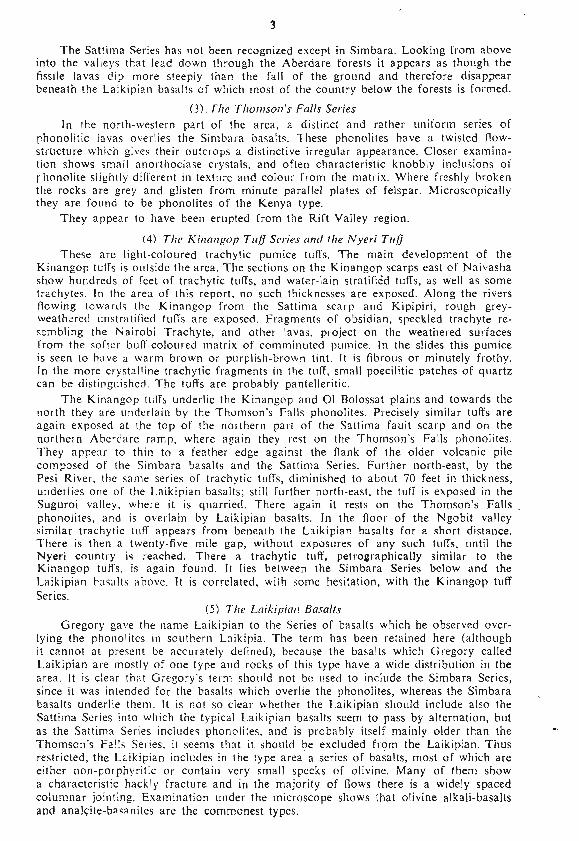
rocks are exposed by the Amboni and Chania rivers, and have been seen also furthersouth as far as Sabasaba and Makindi. (See Fig. l.)
(2) The Sattima Series
The Simbara basalts are overlain, on and around Simbara, by fissile pale-weatheringlavas, identified as phonolites, olivine alkali-trachytes, mugearites, and fissile basalts.
A sheet of porphyritic quartz trachyte, the “Dragon’s Teeth Trachyte”, is closelyassociated with the lavas of the Sattima Series but it is at least partly intrusive.
There was probably an interval between the eruptions of the Simbara basalts andthe lavas of the Sattima Series, as the contact between the two is everywhere sharp, andnot one of the many dykes traversing the Simbara Series was seen to enter the SattimaSeries. Nevertheless some of the dyke rocks closely resemble the Sattima Series lavas,
and may represent their feeders.

M\3‘. 5 UM“, \
I (x‘5"”, u r V.’I‘M-\~J ,‘J-TKI
(
IIl 3
I __-‘_’-
”I WW9 399" - A Kenybe 6- Kcnybz—agglcmerabe , Simbana Seeks (where disbingu'shed)
@ow vans. ELm'kipian Basalt: & Sabbima Series. _ Basement System.magpie 1w 5 Weekybc. Thomson‘s Fans mus. 0' an Borehorzs referred co in buy.
“ 1 FIG. 1Geological Sketch-map showing Mount Kenya and the Aberdare Range [To face p. 2
an“ *
3
The Sattima Series has not been recognized except in Simbara. Looking from abOVeinto the valleys that lead down through the Aberdare forests it appears as though thefiSSile lavas dip more steeply than the fall of the ground and therefore disappearbeneath the Laikipian basalts of which most of the country below the forests is formed.
(3)7718 Thomson's Falls SeriesIn the north—western part of the area. a distinct and rather uniform series of
phonolitic lavas overlies the Simbara basalts. These phonolites have a twisted flow-str'ucture which gives their outcrops a distinctive irregular appearance. Closer examina-tion shows small anorthoclase crystals. and often characteristic knobbly inclusions ofrhonolite slightly difl‘erent in texture and colour from the matrix. Where freshly brokenthe rocks are grey and glisten from minute parallel plates of felspar. Microscopicallythey are found to be phonolites of the Kenya type,
They appear to have been erupted from the Rift Valley region.
(4) The Kinmtgnp Tllfl Series and the Nyeri TuflThese are light-coloured trachytic pumiCe tufts. The main development of the
Kinangop tutfs is outside the area. The sections on the Kinangop scarps east of Naivashashow hundreds of feet of trachytic tufts, and water-lain stratified tufts, as well as sometrachytes. In the area of this report. no such thicknesses are exposed. Along the riversflowing towards the Kinangop from the Sattima scarp and Kipipiri, rough grey-weathered unstratitied tut are exposed. Fragments of obsidian, speckled trachyte re-sembling the Nairobi Trachyte, and other lavas, project on the weathered surfacesfrom the softer bull—coloured matrix of comminuted pumice. In the slides this pumiceis seen to have a warm brown or purplish-brown tint. It is fibrous or minutely frothy.in the more crystalline trachytic fragments in the tttlT, small poecilitic patches of quartzcan be distinguished. The tuffs are probably pantelleritic.
The Kinangop ttttls underlie the Kinangop and ()l Bolossat plains and towards thenorth they are underlain by the Thomson's Falls phonolites. Precisely similar tuffs areagain exposed at the top of the northern part of the Sattima fault scarp and on thenorthern Aberdare ramp, where again they rest on the Thomson‘s Falls phonolites.They appear to thin to a feather edge against the flank of the older volcanic pilecomposed of the Simbara basalts and the Sattima Series. Fttrther north-east, by thePesi River, the same series of trachytic tufts, diminished to about 70 feet in thickness,underlies one of the Laikipian basalts; still fttrther north-east. the tuft is exposed in theSuguroi valley, where it is quarried, There again it rests on the Thomson’s Falls,phonolites, and is overlain by Laikipian basalts, In the floor of the Ngobit valleysimilar trachytic tutl appears from beneath the Laikipian basalts for a short distance.There is then a twenty—five mile gap, without exposures of any such tufts~ until theNyeri country is reached. There a trachytic tuff. petrographically similar to theKinangop tufts. is again found. It lies between the Simbara Series below and theLaikipian basalts above, lt is correlated, with some hesitation, with the Kinangop tuftSeries.
(5) The Luikipimt BasaltsGregory gave the name Laikipian to the Series of basalts which he observed over-
lying the phonolites in sottthern Laikipia. The term has been retained here [althoughit cannot at present be accurately delinedl, because the basalts which Gregory calledLaikipian are mostly of one type and rocks of this type have a wide distribution in thearea. It is clear that Gregory's term should not be used to inclttde the Simbara Series,since it was intended for the basalts which overlie the phonolites, whereas the Simbarabasalts underlie them. It is not so clear whether the Laikipian shottld include also theSattima Series into which the typical Laikipian basalts seem to pass by alternation, btttas the Sattima Series includes phonolites. and is probably itself mainly older than theThomson's Falls Series. it seems that it shottld be excluded from the Laikipian. Thusrestricted, the Laikipian includes in the type area a series of basalts, most of which areeither non—porphyritic or contain very small specks of olivine. Many of them showa characteristic hackly fracture and in the majority of flows there is a widely spacedcolumnar jointing. Examination under the microscope shows that olivine alkalivbasaltsand analcite-basanites are the commonest types.
4
Most of the waterfalls in the district occur where columnar Laikipian basalts havebeen undercut. Examples are those on the Chania just above Nyeri, and others in theAberdare Forest; the Amboni Falls just below the Nyeri~Nanyuki road; and severalfalls on the Zuka Zuka and'Moyo rivers above their confluence.
The Laikipian basalts probably erupted from numerous small volcanoes, the stumpsof which are a conspicuous feature of southern Laikipia. Similar basalts, referred to thesame Series, occur high up on Simbara, eSpecially on the western flank.
The Laikipian basalts are mainly developed east of the Sattima fault, but there isalso a thick series of columnar non-porphyritic basalts of Laikipian type, exposed inthe Wainjohi gorge north-east of Kipipiri. and similar basalts occur in the intermediatefault strip between the two branches of the Sattima fault.
Typical Laikipian basalts are seen to overlie the Kinangop tufl Series near thePesi River, near the Mutara, and along the Suguroi. Their distribution suggests that theywere there erupted on to a surface which was tilted towards the east with the resultthat they did not spread over the surface of the Kinangop tutfs of the 01 Bolossat plains.
The main mass of the Laikipian basalts is believed, for reasons stated below, tooverlie the kenyte agglomerates of the Mount Kenya Suite, bttt the earliest of them areclearly seen to pass beneath the kenyte agglomerates in the Amboni valley. The kenyteswere therefore erupted early in Gregory‘s Laikipian stage. As the Mount Kenya rockswere the chief representative of his Doinyan Series, supposed to be earlier than theLaikipian, it is obvious that this part of his classification is confused. Furthermore,the kenyte of the Amboni valley was identified by Gregory as Kapiti phonolite and soreferred to his Kapitian stage.
(6) Rocks (If the Luikipiuu Von/xMany small isolated hills rise abruptly from the otherwise smoothly undulating
surface of southern Laikipia. These represent old volcanic vents, Few, if any, retainany trace of their original craters. Erosion acting on the scoriaceous lavas and pumiceoustufls of which they are chiefly built has destroyed their original form and only thestumps remain.
The rocks of most of these vents are basaltic. Some are hackly basalts, either non-porphyritic or with small brown altered olivines. Others are highly porphyritic withabundant olivines and augites. Reddish basaltic tutfs usually occur on and around thevents.
Nyeri Hill and Songari consist of trachytic rocks. The Nyeri Hill rock was identifiedby Campbell Smith (I931) as a fayalite-bearing phonolite. On the northern slopes ofSongari there are grey, fissile fine-grained trachytes, but near the triangulation pointthere is a very small outcrop of kenyte The higher southern summit was not traversedduring this survey, but Gregory who states that Songari Hill is kenyte probably refers tothe southern summit.
Rarely lragments of gneiss have been blown out of the vents, and a piece ofKijabe type basalt, indicating the presence of the Simbara Series below, was collectedfrom a tuff at the side of Ol Doinyo Narasha.
The date of the last eruption of one of the Laikipian vents may be known whensome fossils discovered in a basaltic tuff near the Moyo River have been identified (seep. l2). 1n the opinion of Dr. Leakey, they may be either Lower or Middle Pleistocene,but probably the former.
(7) The Alount Kenya SuiteThe north-eastern part of the area is a gently rolling plain, traversed by shallow
rather featureless valleys, along the sides of a few of which there are discontinuousexposures of agglomerates with blocks of kenyte and green lissile phonolite. Near theAmboni and one of its tributaries, kenyte lava is exposed. Fissile phonolites were seenby a stream about five miles north by west of Nyeri Station, and in a single outcropon the slope north of the Naromoru river. From such scattered outcrops, the extentof the area underlain by these various rocks can be approximately determined. Theonly place where their contact with the Laikipian basalts was actually seen was onthe north side of the Ambonl valley, where kenyte agglomerates and lava overlie a basalt

. 5
of Laikipian type. The whole of the western boundary shown on the map is conjectural.lt is draWn on the assumption that the Laikipian basalts which outcrop along a lowscarp, overlie the kenyte agglomerates of the low ground east of it.
The kenyte agglomerates and lavas, and the phonolitic lavas mentioned, are part ofa continuous field of such rocks which can be followed up the lower slopes of MountKenya. so that there is no doubt that they were erupted from the former Mount Kenyavolcano. Pieces of nepheline syenite like that of the central plug of Mount Kenyaare sometimes found in the agglomerate. '
The kenyte aggionierates by the Amboni River near the Nyeri—Rumuruti road.rest directly on agglomerates ol‘ the Simbara Series. Further down the Amboni, on theother hand, there are a series of basalt flows of Laikipian type between the Nyeri tuffbelow and the kenyte agglomerates above.
(8) Pleistocene and Recent Superficial DepositsThese are thin unconsolidated or semi-consolidated deposits which have accumulated
since the volcanic eruptions ceased. There is little evidence by which they can be dated.The deposits are classified into the following typeszi
(a) Naromoru ash.(Ii) Moraines.(c) Solifluxion deposits.(d) Red soils.(e) Red and pale lateritic earths.
, (f) Black soils.(g) Alluvium.
(a) The Nm-mnoru Ash—This is a thin deposit of greenish—grey tuffaceous materialoccurring in many parts of southern Laikipia, notably near Naromoru. Its mostcharacteristic feature is the constant presence of small flakes of biotite. It is uncertainwhether the deposit is pyroclastic.
in this area it is usually unstratified, out in the valleys, similar material (or thesame, re-deposited), is distinctly stratified and contains small gritty fragments of kenyteand other rocks derived from Mount Kenya. These stratified deposits are termed theUaso Nyiro Beds in’the Nanyuki area (Shackleton: Maralal Report).
The Naromoru ash is younger than a Lower or Middle Pleistocene basaltic tuff(see p. 12) and older than the Late Middle Pleistocene Kenya Fauresmith horizon (seeparagraph (6) below). It is exposed beneath black soil in many roadside pits. “Kunkar”concretions commonly occur both in the ash and in the lower part of the black soil.
(b) M0raineS. These are confined to the highest valleys on Simbara. They arebelieved. to 'be of the same age as those on Mount Kenya referred to the UpperPleistocene Gamblian Pluvial Period (see p. ll).
(c) Solifluxion Deposits—Material believed to have accumulated as a result ofsolifluxion occurs on Simbara (see p. 10).
The fact that the Honi has cut a channel 20 feet deep through one of the depositssuggests that its age is Pleistocene and not Recent.
((1') Red Soils—These are typically developed in the Nyeri area where they areoften ten or twenty feet thick. They are unstratified and homogeneous, and appearto result from rock decomposition under forest cover during a long period of time. Theyhave not yielded artefacts and it seems likely that the forests under which they formedwere uninhabited by prehistoric man.
(e) Red and Pale Lareritic Earths—At many places east of the limit of the area,erosion has exposed a series of red and pale lateritic earths. In the lowest of these, arich red earth, artefacts of the Kenya Fauresmith (Nanyukian) culture have been found.At Leakey‘s type locality for this culture (Leakey, 1931) by the road to the NanyukiForest Station, red earths in which the artefacts occur, rest unconformably on thebiotite-bearing Naromoru ash. Within the area of the map, artefacts of the KenyaFauresmith culture have only been found at a few places near the Pesi River. Theselocalities were discovered and shown to me by Mr. T. .P. O‘Brien. They are in eroded

6
patches and the sections show a foot or two of lateritic earths at or near the base.overlain by yellowish. brown to grey soils with “kttnkar” concretions. There are arte-i‘acts, mostly .unrolled, of Kenya Fauresmith, Levallois and other types. Some. withadhering laterite are obviously derived from the basal lateritic horizon, but none wereseen in situ.
0‘) Black Soils—These cover most of the flatter ground. With them are includedsome brown soils into which they pass on slightly more sloping ground. Both theblack and brown types have concretions ol~ “kunkar lime" at their base,
The distribution of the red and black soils depends on lpe, which controlsdrainage and consequently oxygenation, rather than on the nature of the bedrock. Bothred soils and black soils are typically developed on basalts, phonoiitcs and trachytictuffs in this area.
(g) A11uvium.~Ailuvium has been deposited during the sitting tip of Some of theflatter valleys such as the Moyo. Gravels are surprisingly scarce and insignificant.
lV—CORRELATION WITH OTHER AREASA provisional correlation of the principal volcanic rocks and superficial deposrts
is given in the table. Some of the evidence on which the table ts based is discussedbelow.
(1) Correlation 0f the Oil/(’I' Bum/lit ROCKYThe Samburu Series, the Simbara Series and the Ngong basalts are thought to be
approximately of the same age, principally on account 01' their pettogmphic similarities.Basalts of Kijabe type are characteristic of the Sttmbttru Series and the Simbara Series.Melanocratic basalts with olivine and allgllc phenocrysts occur in the Stunhuru Serieseast of Baringo, in the Simbara Series in Sinibara. and in the Ngong basalts. Basaiticrocks are known to occur low in the volcanic succession in western Kenya (Kent, W44,pp. 16—18), and in the Lake Rudolf Basin (Arantbourg, i935; Fuchs, 1939, pp. 230-246);the description of the Miocene basalts and tufl‘s of the Losidok Hills west of LakeRudolph tibial, p. 23!) indicates that they are very similar to the Samhuru Series of thenorth-western part of the Maralal area. In the Tambach—Kabarnet area at the westernside of the Kenya Rift Valley, Mr. J. Scott ol~ the Public Works Department determined(personal communication) the following succCSsion: ——
Kabarnet Trachytes.Stratified tufis, etc. (? Kamasian).
. Uasin Gishu Phonolite,
. Basalt.. Conglomerates, grits and green tufl' (? Miocene).. Gneiss (Basement System),_
.Nw
J-yi9
\
Thus here also basalt occurs at the base 01' the volcanic series.The presence of a flow of Kijabe type basalt between the Thomson's Fails Phono-
lites and the Rumuruti Phonolites, near the Post River (Shackleton, Maralal Report)suggests that the last of the basalts of the Simbaia Series were erupted later thanthe Rumuruti Phonolites.
(2) Correlation of the Kinangop 'l'ttfls, Nyeri 'l'ttfi and Stttrima SeriesThe Nycri turf is correlated with the Kinangop tuif on account of its similar
lithology, and because it lies in the same relation to the Laikipian basalts as thetrachyte turfs of Ngobit, Suguroi and Mutara, which undoubtedly belong to theKinangop tufis.
The Nyeri tui‘f contains cognate fragments of a quartz-trachyte which resemblesthe porphyritic quartz-trachyte of the Sattima Series, but their correlation is questionable.
(3) Relative Age 01‘ the Tracltytic Tufls and the Mount Kenya Volcanic SuiteIn View of the occurrence of trachytic tufis at many horizons in the Nairobi
sequence, the suggested correlation of the Kerichwa valley tutf with the Nyeri andKinangop tuffs is open to doubt. It is possible that the Kinangop tuf’fs and the Kerichwavalley tufis are in part younger than the Mount Kenya Volcanic Suite.

7
V——PHYSICAL AND GENERAL GEOLOGYThe area is one where the form of the ground clearly reflects the main geological
features. Most people familiar with the district are aware of differences in terrain, soil.rocks and drainage, between for example, the Kinangop plateau, the Aberdare farms.and the coffee growing areas around Nyeri. These depend on differences in the rocksand their structure. '
The chief physiographic units (see Fig. l) are:—— -(ll The Kinangop Plateau.(2)The OI Bolossat Plain.t3) Kipipiri.(4)The Sattima Fault Scarp.(SlThe Northern Aberdare Ramp (northern part of the Aberdare Range).toiSimbara (the mountains) (northern part of the Aberdare Range).(\7) Crusiru (the moorland) (northern part of the Aberdare Range).(8) The Aberdare Dip-slope.(9) Southern Laikipia .
(l) The Ki/urngop PlateauThis IS a platform about ten miles wide, with an elevation of 8.000 to 9.000 feet.
It extends westwards from the foot of the Aberdares to the upper Kinangop faultscarp. Only a small part of it. south and south-east of Kipipiri. is included in the areadealt with in this report.
The margin of the lx'inangop plateau is a distinct topographic feature whichcorresponds, within perhaps half a mile. with the geological boundary between thetrachytic tulls of the plateau and the basalts of Kipipiri and the Aberdares. It followsan irregular course round Kipipiri and southwards along the foot of the Aberdares.marking the unconformable contact between the Kinangop tuffs and the underlyingbasalts.
The surface of the Kinangop is conspicuously smooth. It is the marginal stripof a plain of accumulation which formerly extended from the foot of the Aberdaresand Kipipéri across the Rift Valley region. and probably also eastwards across thenorthern end of the Aberdares.
The trachytic tuffs of which the Kinangop is built are well exposed along theSasin river.
(2) 0] Bn/mmr Plain (Angata Pusl(Jeologically. this is a continuation of the Kinangop. It is formed of the same '
trachytic tufl's. built up to a similar even surface. The marsh of Cl Bolossat is thedwindling relic of a former lake, lts existence at the foot of the Sattima fault scarpindicates that when the faulting occurred, the rocks of the Cl Bolossat plain were tiltedeastwards. and a lake thus formed by the water impounded against the scarp. ltsdisappearance is doubtless due to silting up, as well as to the progressive desiccationof the country since the Upper Pleistocene (Gamblian) Pluvial phase.
(3) Kipipr'riThis enormous mound rises some 3.000 feet above the surrounding plains to
10,987 feet. lts sides are furrowed by radial valleys and covered with dense bush andforest. lt stands apart from the main Aberdare Range, from which it is separated by asaddle deeply trenched by the streams draining either side.
The rrofilc of Kipipiri is similar from each side and except for a spur extendingnorthwards, it is nearly round in plan, with a diameter of about seven miles. ltssymmetrical form suggests that it is an old volcano and outward dips in the lavas ofwhich it is formed confirm this. From the l:l25,000 map one might indeed supposethat traces of the original crater perhaps still exist, but from the summit it is obviousthat. this is not the case. Several of the higher points are connected by a curvedridge, with a flat area between them. but there are others nowhere near this ridge, whichhas been formed by erosion. Moreover the profile of the mountain is no longer that ofa simple cone. It is clear that it has been IOWered by erosion hundreds of feet below itsoriginal height. -‘ . >

8
Three groups of rocks were seen on Klpipiri. There is rt core of basalts of theKijabe type; many thin flows are exposed in dark elill‘s at the sides and head of theradial valleys, and similar rocks were seen in valleys along the western side of themountain. This series of basalts is overlain by trachytes which form the pale slabbyoutcrops of most of the highest points, and extend down the north ridge and nodoubt also down some of the other unexplored ridges. On the northern spur, and inthe saddle between Kipipiri and the Aberdares, there are llows of columnar non-porphyritic basalt. A small hill near the end of the northern sptrr may mark one ofthe vents from which these basalts erupted.
The volcanic succession on Kipipiri is so similar to that of the Aberdares thattheir correlation is not in doubt. The Simbara Series is represented by the older basaltsof Kipipiri, the Sattima Series by the tr'achytes, and the Laikipian Series by thecolumnar basalts of the saddle.
Kipipiri is thus as old as the Aber'dares. It is not, as has generally been supposed,a younger volcano located on the Sattima fault.
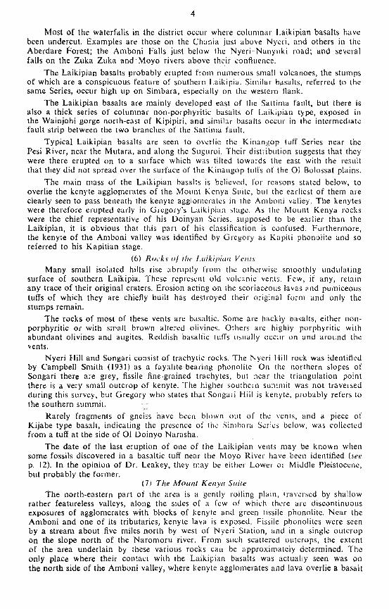
(4) 71w Sallima Fault Sc'urpThe Sattima scarp is a long straight and steep rock face (we Pl. 1 (all. It bounds
the northern Abetdare ramp, and the high part of the range itself, from Thomson‘sFalls to north Kinangop. a distance of about 4t) miles. The height of the scarp increasesgradually from Thomson's lalls southwards. and then again declines still further south.Although the fault lace is incised by sortie deep and pl‘ctflpilUUs-sitlctl valleys, notablythose of the several branches of the Melawa and the Wainjohi, the scarp betweenthese incisions is little affected by erosion. It has the appearance of a geologicallyyoung feature.
Along one 7-mile stretch the fault is split, and as explained in more detail later,the geometry of the outcrops of the outer (eastern) branch suggests that it is inclinedwestwards. If so, the fault would be normal, that is tensional. As it is one of theprincipal boundary faults of the Rift Valley, proof that it is ten.,ional would be hardto reconcile with any theory of the compressional origin of this Kilt Valley.
Another point of interest is that the Sattima faulting appears to have taken placeafter the deposition of the Kinangop tut‘fs; the continuation of the tutfs of the 01Bolossat plain is found at the top of the scarp.
(5) The NON/tent Abcrdm'c RampIn most parts of the Aber'dare range the present slope of the ground has been
determined both by the original siope ol‘ the volcanic rocks, away front their centreof eruption, and by subsequent tectonic tilt. There is, howet'er, an area at the northernend of the range where the original volcanic surface was nearly flat, and the presentslope is almost entirely the result of tilting. This area is described here as the northernAberdare ramp. To the north and north-east it merges into the tlatter plains and flatterstructures of Laikipia.
The rocks of the ramp are the Thomson‘s falls l’honolitcs and the Kinungoptrachytic tufl’s. They are exposed in section on the Sattima fault face. There it is seenthat the phonolites thin southwards to a feather edge on the Simbara basalts. Restingon the phonolites and extending to the very edge of the fault scarp are the Kiuangoptrachytic tutfs.
The river system of the ramp is interesting. The streams flow onto it from the oldSimbara cone where they have a radial pattern, but as they run out over the ramp,instead of continuing in their previous courses, they swerve to the right, away from theedge of the Sattima scarp towards Laikipia, and the Sattima scarp drains only a smallarea of the edge of the ramp. The courses of these rivers across the ramp is proof thatthe Aberdare Block, as it was uplifted, was gently tilted towards the east. There is nosign of any pre—tilt drainage pattern, from which it appears that the faulting andmovements followed very soon after the eruptions had ceased.

PLATE I
((UViCW northwards along the Suttima Fault Scurp. from a point two miles NE.of Kipipiri. This part of the scarp consists of basalts of the Simbara Series. The gentleslope in the middle is formed of talus. At the lel‘t is the OI Bolossat Plain. formed oftruchytic tulls.
(1)) Part of the §zittimzi scarp. showing the feature due to the eastern fault. The bush—covered slopes to the left of the fault feature are formed of nearly horizontal basalts ofthe Simbara Series. The smooth slopes below are formed by basalts of the LaikipianSeries, covered with talus The eastern edge of Kipipiri is seen across the end of the01 Bolossat Plain. at the right. The view is taken looking south-eastwards.
P/mlu. R.M.$. [To face I). 8
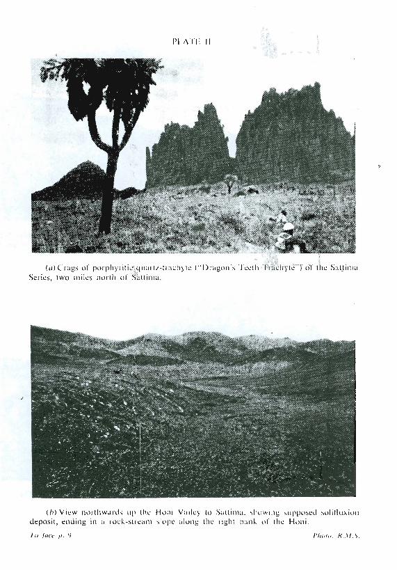
H A ll. ||
(ulClugs ol~ pmph):iliUqnzu‘lz-Imct (“|)l'21g0n\llccll1 'l rucll)‘lc"l(3l lhc SulllnmScrics, two ”11l IlUllh ol‘ Sullimu.
lb) Vicw northwards up (he lluni Valle) In Sullinm. slmwmg \npposcnl solllluxiondeposit, ending in u l'ock—slrcznn \Iopc along [11c right bank 01' the Honi,
'l’u java [1. 9 I’lmru. RAIN

9
(6) SimbaraSimbara is the name applied by the Kikuyu to the high mountainous part of the
northern Aberdares. The name Sattima, given to the highest point on the maps, isseldom familiar to them. Sattima is not an isolated peak, but the inconspicuousculmination of a considerable area of high ground. Simbara is uninhabited; most of thehills are unnamed and the streams have only the names of the rivers into which theyflow. Existing maps are misleading and inaccurate. Simbara in the sense used by thenatives corresponds roughly to the area occupied by the two older divisions of the localvolcanic rocks. These are the Simbara Series below, and the Sattima Series above;together they form the old volcanic core of the northern Aberdares.
The rocks of the Simbara Series, as shown on the map, are exposed in the valleysof Simbara and on some of the ridges. Some deeply incised valleys show over athousand feet of basaltic lavas and the base of the series is nowhere seen. The lavaflows are thin, vesicular and mostly of porphyritic basalt of the Kijabe type They arereadily weathered and often underlie grassy slopes with few outcrops. Sleeper androckier slopes show dark parallel outcrops of a great number of thin flows.
The Simbara basalts dip outwards from the central part of Simbara. They aretraversed by dozens of dykes, mostly of porphyritic basalt similar to the lavas. Someare of pale fissile trachyte and a few of phonolite and non-porphyritic basalt. Asshown on the map, many of the dykes belong to a radial system evidently centred onthe main eruptive focus. which is less closely defined by the dip of the lavas outwardsfrom it, Besides the radial dykes, there is a linear swarm (inadequately shown on themap) along the axis of the range, parallel to the Sattima fault. Most of the dykes of thisswarm, are nearly vertical.
Other dykes have no obvious regularity. Their direction often changes abruptly,and- some are branched. Few of the dykes are more than ten feet thick and many area foot or less. In the other areas where the Simbara Series is exposed, along theSattima scarp, in the Amboni valley, by the Chauia below Nyeri, and elsewhere, nodykes were seen and there certainly cannot be many, although an occasional one mayhave been overlooked. The dykes are apparently confined to the Simbara Series; nonewere seen in the overlying rocks.
Although it is evident that the Simbara basalts were erupted from a centre a mileor two south of Sattima, no plug or vent was discovered, nor any topographic featureto suggest one. Several small rock knobs were found to stand out where the basalticlavas were reinforced by dykes. Nor were any blocks or boulders of plutonie rocksfound anywhere in the northern Aberdares.* .
It is presumed therefore that the dykes, of which there are many more than couldbe shOWn on the map, mark the fissures from which the lavas were erupted.
The dominant lavas of the Simbara Series are Kijabe type basalts crowded withporphyritic felspar crystals. On the northern and southern flanks of Simbara, however,the prevailing type is a basalt with many visible crystals of olivine and augite. Invarious places they can be seen to overlie the other type of basalts; they are themselvestraversed by dykes, and overlain in at least one place by a trachyte of the SattimaSeries. They form the subordinate upper division of the Simbara Series.
The Sam'ma Series includes pale—weathering slahby and fissile rocks which, On thesummits of Simbara and on Kipipiri. overlie the Simbara basalts. They includeporphyritic quartz-trachytes, t'ayalite alkali—trachytes, alkali-trachytes, and phonolites.Of these, the porphyritic quartz trachytes are at least partly intrusive, as dykes and asheet, but the others appear to be lavas. They occur chiefly as isolated outliers.
The porphyritic quartz trachyte is the most striking and conspicuous rock in thewhole district. (Plate 11 ((1).) Down the western slope of Simbara it forms bizarreoutcrops, comb-like outliers on the ridges, vertically fluted and serrated crags, andfields of pronged and knobby rocks. In the field the rock was named the Dragon’s TeethTrachyte.
G in the foothills and on Laikipia, stones of nepheliue sycnite the size of a tennis ball or lessare sometimes found, but these are from Mount Kenya and were carried, and often shaped byprehistoric men for throwing-stones or bolas balls. The only plutonic rock yet known in theAberdares is a gabbro (? essexitic), of which many blocks were found in the Turasha River nearTulaga, west of Niandarawa. (Spec. 43/65.)
:fA
{>9

10
At first this formation was taken for a lava sheet. In most of its exposures itdirectly overlies the Sintbara basalts, but near the Melawa tributary tour miles south-west of Sattlma the sheet is overlain by other Simbara Series basalts, similar to thosebelow it. In some of the valleys which cut into the Sattima scarp the same quartztrachyte sheet could be seen from below to cttt transgressively through the great seriesof Simbara basalts. The sheet dips across the nearly fiat lavas at angles up to 15°, andis here clearly intrusive. Near Sattima a similar rock whtch overlies a non-porphyriticalkali-trachyte of the Sattima Series may be a lava. Its connexion with the other fissilelavas is in any case certainly close. There are many dykcs 01' similar rock.
The other rocks of the Sattima Series are apparently lavas.In Simbara, which is probably the centre from which they were erupted, the
Sattima Series is distinct, but on Gusiru, similar lavas are interdigated with basalts ofthe Laikipian Series, and it has not been found possible to show the limit of the SattimaSeries on the map. Low down on the western slope of Simbara, ltowe\ er, non-porphyriticbasalts of Laikipian type were mapped, clearly overlying the porphyt'itic trachyte and theSimbara basalts.
Glacialion of St'ntbara.——lt has been known for some time that there were at onetime glaciers on the Aberdares (Nilsson, 1940, p. 4). The ttiOst convincing evidence ofthis glaciation is to be seen at the heads of the two main branches ol‘ the Melawa NdogoRiver. In each of these, typical lateral moraines slant down the side ot the valley tothe lower end of an alluvial fiat which evidently covers a small rock basin, now silted up.The heads of the valleys, above these old lake basins, have the scooped—out appearanceand U~shaped cross-section typical of glaciated valleys, while immediately below thelips of the basins the valleys drop steeply and have the V-shaped ct‘oss»sccti()tis typicalof river erosion. in the northern Melawa valley there is another small moraine abovethe old lake bed. The glaciers in these valleys reached down to about l2,000 feet.
At the head of the Wainjohi there is also an area whose lorm suggests glaciation.No moraines or old lake beds were seen there, bttt there is a distinct lip where thesupposed glaciated part gives place to the V-shaped valley below, and this lip lies atabout the same elevation as those in the Melawa valleys. In the Ngobit, moraine ridgesconverge towards the lower end of a fiat-tloored area that was evidently glaciated;below this the valley is deeply cut.
The small glaciers in these valleys lay round the western and northern side of thehighest ridge of Simbara. The eastern side of this ridge drains into the Honi, aroundthe head of which the highest summits are grouped, Yet no evidence of glaciation wasseen at the head of the Honi streams, which rttti, on the contrary, iti deep V-shapedvalleys. Further down the narrow headstream valleys join and the valley becomes moreopen. There, for about a mile along the right batik ot‘ the Honi (Plate ll, fig. 2, opp.p. 9) there is a deposit of large and small blocks 01‘ the rocks from the ridges above, inan earth matrix. The deposit ends in a steep slope along the right batik of the Honi.There is no corresponding slope on the other side of the stream. The slope must be anoriginal feature and not the result of a stream erosion.
Away front the stream, the surface of the deposit slopes smoothly tip and mergesabove into the stony earth which covers the hillside as far as the rock outcrops near theridge. This cover, which is seen 011 most of the less steep hillsides ot' Simbara, isintricately and closely furrowed by a reticular pattetn of alleys. some of them severalfeet deep, running transversely to the slope of the ground. The whole ol' this furrowedcover is believed to move by solifiuxion, the embankment—like lower edge marking thelimit of its flow. The downstream limit of this deposit is indefinite. Three successivesmooth terraces which were at iii‘Sl interpreted as dril't, were found to be lava scarpspartly buried by detritus and soil.
Still further down, below these terraces, the stream. flowing east, plunges suddenlyinto a mass of loose rocks and earth, through which it has cut a narrow channel, abouttwenty feet deep. The deposit here is similar to the one upstream. it lies across themiddle of the valley, merges imperceptibly into the slopes on either side, and nonoticeable feature marks its lower limit, which is at an elevation of approximately10,700 feet. A similar deposit was seen in the Chania valley at about the same elevation.

11
These deposits, and the glaciatiOn of Simbara, deserve more study than was possibleduring hurried traverses. It is plausible to correlate the glaciation down to about12,000 feet with the glaciation down to about the same leVel on Mount Kenya. Thishas been regarded (Nilsson, 1940, p. 70) as marking the maximum of the GamblianPluvial Period. It might be suggested that the deposits here attributed to solifluxion are -denuded moraines of an earlier and greater glaciation, but the form of the deposits andof the valleys above them would then be difficult to understand.
(7) GusiruQuite distinct from Simbara is the plateau to the south, known to the Kikuyu as
Gusiru, the moorland. A long but inconspicuous spur from Simbara extends along itswestern side; it drains eastwards. Its eastern edge, coincident with the upper limit ofthe bamboo forest, is sharply defined, the ground falling away there in a steep andsudden slope.
Some of the rocks of Gusiru are basalts, non—porphyritic dark blue-black rockswith columnar jointing. Others are fissile rocks, paler weathered, bluish-grey withinand glistening on broken surfaces with minute felspar plates. These fissile rocks areprovisionally identified as mugearites and fayalite alkali-trachytes. Some of them seemto be identical with some of the lavas of the Sattima Series both to the eye and micro—scopically, nor could any distinction be drawn in the field. It is quite clear in the streamsections on Gusiru. such as those along the Gura and Chania rivers, that the columnarbasalts and the fissile lavas alternate and were being erupted at the same time. The-northern part of Gusiru seemed. so far as could be seen from the few exposuresnoticed on two traverses, to consist entirely of the fissile lavas.
The flatness of the plateau is in striking contrast to the steep slope down throughthe forest. The gentle slope is little greater than the gentle eastward dip of the sheetsof lava which build the plateau. Several low sinuously embayed lava scarps, facingeast, mark the edges of successive sheets. Near the eastern margin, there are severalisolated hills which are obviously old vents. The NyerireNaivasha track traverses theflank of one of these a mile east of the Gura bridge. Purplish basaltic tufts, agglomerates,and rubbly lavas confirm the proximity to a vent. The arrangement of these vents nearits edge may have protected the plateau from erosion while increasing the steepness ofthe slope to the east. The eastward dip of the lavas in the forest is probably steeperthan it is on the plateau and this would favour faster and deeper erosion. Possibly too,the plateau was protected by the relatively hard sheets of the fissile lavas. There isnothing to suggest faulting at its edge.
The several ponds, meres and marshes on Gusiru are said to be shallow. They maybe due to the unequal accumulation of silt trapped by rushes and other vegetation.Those seen were in flat peaty areas, on the broad shelves formed by the gently dippinglava sheets.
(8) The Aberdare Dip-slopeBetween Gusiru, Simbara and the ramp to the west, and Laikipia to the north-east,
is the Aberdare dip—slope. This, although deeply furrowed by valleys. slopes evenlywith an average gradient of about I in 15. Most of it is covered by the Aberdareforests, through which few traverses were made. Phbtographs of some waterfalls on theChania show columnar lavas, presumably basalts, and the pebbles in the streams aremostly of basalt and fissile lava. Below the forest boundary the deep valleys of theGura and Chania expose both columnar and fissile lavas, dipping at about the same angleas the general slope of the surrounding country. It appears that the dip-slope is largelyformed of lavas of the Laikipian Series, but whether some of the fissile lavas shouldbe included in the Sattima Series is uncertain.
At the eastern foot of the dip-slope, around Nyeri, other rocks emerge in thevalleys, from beneath the Laikipian basalts, as shown on the map. The oldest lavasand agglomerates of the Simbara Series, are well exposed in the cuttings along theNyeri—Nairobi road on both sides of the Amboni valley. Agglomerates alternate with

12
lavas. Otherigood exposttres of the Sitnbara Series can be seen on the steep slopes.above the confluence of the Chania and Amboni. Flows of melanocratic basalt withaugite and olivine phenocrysts occur here among agglomerates in which most of theblocks are of Kijabe type basalt,
The Simbara Series is overlain in this part of the area by the Nyeri tulf. a bed.of columnar trachytic tuff usually about 30 feet thick. This tul’f is used as a buildingstone and is well-exposed in numerous quarries and natural exposures. By the Chanialeast of Nyeri, feebly stratified tutfs were seen below the massive bttilding stone. Thecontact of the Nyeri tuff with the underlying Simbara Series was nowhere seen.
The surface of the Aberdare dip—slope is in general deeply weathered to a rich.red soil, and rock exposures are seldom seen except in the valleys with running streams.
(9) Southern LaikipiuThe southern part of the extensive grass-covered plateau of Laikipia is included
in the area dealt with in this report. lts limit is taken to be where the black soil of theplains gives way to the red soil of the Aberdarc dip-slope. This corresponds to theformer boundary between grassland and forest. The areas covered by black soil are dis—tinguished by stippling on the map. The change in soil depends chiefly on drainage andslow, and is very little influenced by the nature of the underlying rock.
Much of southern Laikipia is formed of basaltic lavas of Gregory's LaikipianSeries. These are well exposed in the Ngobit valley near the Nyeri—Rttmuruti road,and in many other places.
Small hills rising above the plains are the stumps of the many small volcanoes fromwhich the surrounding Laikipian basalts were erupted. Reddtsh basaltic tufi's are com-monly l'ound on and near the vents. Some of these tufi‘s have been used for buildingstone and in one of the trial holes on a farm north of the Moyo River some fossil boneswere discovered by the owner, Colonel Elliot. The tutf in which they were found lies ona gently sloping ridge. Other exposures on the side of the same ridge show similarbut less weathered tufi's, reddish in colour and typical of the lapilli tutt's discharged frommany of the Laikipian vents. These tutl's overlie Laikiptan basalts. The bones are un-rolled and apparently articulated in their original position. It is supposed that theyare the remains of animals buried in a sudden shower of “ash” and lapilli; if so, furtherfinds are not very probable. The fossils have not been finally identified, but Dr. L. S. B.Leakey, to whom they were sent, informs me that the fauna includes a baboon not sofar identified with any known species, but having affinities with a Lower Pleistoceneform from South Africa. He is of the opinion that the fauna is not younger than MiddlePleistocene and is more probably Lower Pleistocene in age.
In the pit where the fossils were found, the basaltic tutl’ containing them is overlainby a layer, less than a foot thick, of pale brownish ash with biotitc llakes. This is thoughtto represent the Naromoru Ash. The eastern part of southern Laikipia is underlain by therocks of the Mount Kenya Volcanic Suite, but over most of this part of the area, blacksoil conceals the underlying rocks, which are seldom exposed except along the sides ofthe principal valleys.
In many parts of Laikipia the black soil of the plains is underlain by the Naromoruash.
Vl—PETROGRAPH YA preliminary examination of about two hundred thin sections made from the
rocks collected shows that similar types occur in various parts of the sequence, althoughsome are locally restricted to a particular horizon or series. It appears from this firststudy of the slides that a continuous series can be traced from olivine basalts tophonolites and trachytes, and that any member of this series is liable to occur almostanywhere in the sequence. To avoid repetition, a sketch of the petrography of thechief types is given below without regard to their order or place of eruption. It shouldbe realized that the classification is tentative since no analyses are available for mostof the types, and hurried microscopic identification, espeCIally of the potash-bearingplagioclase felspars and the occult felspathoids, is uncertain.

13
The principal rock types distinguished are:—
Olivine basalt. .. .. .. ..()livino alkali-basalt, .Annlcite basnnite .. .. . . J’ B3 2 84 (06)Olivine trachybasalt . . . . . .Mugeaiitic basalt . . . . . . . . } f 2-80 (9)Mugcnrite . . . . . . B 2.75 (9)Olivine alkali- t1achyte . . . . } YT' 2‘70 (12)Alkali tracliyto .. .. .. 1 2-74 (4.)Quartz bracliyte . . ' . . . . — Tr 2-65Phonolite, non propliyritic fissile . , fPl) nmi kPh 2'87 (1 i)Pliouolite . . . . . , , . . .Ph2 2-60 (4)Kenyte . . . , . . . K 264 (2)Basalt, Kijabe type » I31 283 (8)Basalt; \\ ith olivine and uugite pint um I )sts Bp 3'08 (3)
The symbols are thOse used on the map, Figures on the right are mean specific gravities.the figures in brackets showing the number of specimens measured.
Other types of extrusive rocks noticed are picritic basalt and nepheline basanite (7);trachytic and basaltic tufls occur; a few other rocks are found as ejected blocks in someof the tuffs.
Olivine BasaltThese rocks are generally non-porphyritic, and have basaltic texture. They are seldom
vesicular. They consist essentially of olivine, augite, labradorite, and opaque ores.There is no obvious alkali tendency. Residual potash-felspar, analcite, and reaction-biotite are absent or insignificant. The pyroxene is augite, usually only faintly purplish,and non-pleochroic. Olivine is colourless in section, and optically positive. Apatite wasvery rarely noticed. Secondary minerals such as gtithite, iddingsite (7) and serpentine,derived from olivine, are not uncommon.
Rocks of this type mostly with columnar jointing, were found south of Nyeri, pon the Aberdares, near the Ngobit River, on ll Pejeta, north of Nyeri Station, westof Ndaragwa, by the Zuka Zuka River, and at many other places.
Qlivine Alkali—barn]!The basaltic rocks classified under this head are those which contain sufiicient'
biotite to indicate a definite alkali tendency, but which are without appreciable amountsof potash-felspar or analcite. The biotite is the variety usual in such rocks, pleochroicfrom pale golden brown to foxy brown. It forms ragged poecilitic plates, or small flecks.[t ‘has seldom grown on ore grains and seems to have crystallized directly from apotassic residuum rather than as a result of reaction between such a fluid and pre-viously crystallized ores. Apart from the presence of biotite, these rocks are similarto the olivine basalts. Some contain small phenocrysts of olivine. No feature was noticedby which they could be recognized in the field.
Rocks of this type were collected from the Gura Falls, a little way north of theNyeri~Naivasha track; from the west side of Simbara where they overlie the quartz-trachyte sheet; from the Sattima scarp, above Kijabe type basalts and from the upperPesi, Suguroi. and Segara river valleys in each of which they overlie trachytic tuffs. Onespecimen (43/157) from a 6 ft. dyke in Simbara is of this type.
Analcite BasaniteIn 19 of the slides of basaltic rocks, a colourless isotropic mineral with a low
refractive index, was determined as analcite. It is interstitial and residual but apparentlyprimary. The rocks are otherwise normal basalts with faintly purplish augite, colourlessolivine in many cases partly or wholly altered to an iddingsite-like mineral, specks andminute crystals of ore (often identified by its form as magnetite), and plagioclase laths.

14
The plagioclase is generally labradorite, though occasionally it appears to be less basic-The texture is usually basaltic. In one thin section the pyroxene is sub-ophitic, and inanother, the plates of labradorite are firrxionally arranged. Many of the rocks havephenocrysts or microphenocrysts of olivine,
About half of the specimens were of columnar basalts, all but one of which belongto the Laikipian Series. The exception (43/224). collected near the Uaso Nyiro clase tothe Aberdare forest boundary, is a basalt with phenocrysts of olivine and augite. Itprobably belongs to the upper division of the Simbara Series. Another rock with olivine-and augite phenocrysts, also from the Simbara Series, has interstitial zeolitic materialwhich may represent decomposed analcite.
Olivine TraclzybasallFive rocks to which this name was doubtfully given have basic plagioclase as the
chief felspar, but with it, a little alkali felspar which seems to be orthoclase. In otherrespects the five rocks ditfer; they are not a natural group. One (43/249) has trachytic-ally arranged felspar plates, the larger of which (about 0.5 mm. in length) are labradorite,Ab45 An“, and the smaller, oligoclase-andesine and orthoclase. There are granules offaintly yellowish ferriferous olivine, and pale greenish augite. Another rock (43/170)consists of fiuxionally arranged labradorite laths, clear olivine grains, pale greenishpyroxene, serpentine, and alkali feispar. Specimen 43/269 is a fissile lava with labra-dorite, faintly purplish augite in poecilitic patches, and magnetite; some orthoclase formsfringes on the plagioclase and some is interstitial. These three rocks are fissile. AnonAfissile basalt (43/289) which may belong here consists of labradorite (Ab,5 An“),olivine altering to iddingsite, greyish interstitial pyroxene, ore and scanty untwinnedalkali felspar presumed to be orthoclase.
Mugeurilic Basal!These are fissile lavas which, like the mugcarites and alkali trachytes, consist of
trachytically arranged felspar plates, with ferriferous olivrne grains, and subordinategreenish pyroxene, but with andesine instead of oligoclase or anorthoclase. The olivine,when fresh, is yellowish in section. In some of the rock; it is replaced by iddingsite ('2).
In several of the sections, scraps of biotite were noticed and in a few small apatiteprisms with minute inclusions. There are the usual ore specks.
Mugem‘ileAbout a dozen of the specimens are classified as mugearites. They are bluish-grey
fissile non-porphyritic rocks, in which minute glistening felspars are visible. In slides thetrachytically arranged felspars are seen to be mostly oligoclase but probably there isusually also some anorthoclase. The l‘elspars have refractive indices below that ofcanada balsam, even those whose extinction angles would be taken to indicate andesine.Probably they all contain a notable proportion of potash, Zoning and lamellar twinning.are generally faint but distinct.
Olivine is plentiful, occurring in minute granules, which are identified by theiryellowish colour and optically negative character as fayalite. l’yroxene, subordinate toolivine, is greenish diopside or aegirine-augite. Small prisms of apatite, dusted withinclusions, were seen in several slides. Ore specks are scattered much less thickly thanin the basalts. Late primary biotite is rare. Secondary iddingsite and serpentine arecommon.
Olivine Alkali-TraclryleIn texture and general appearance both to the eye and microscopically, these rocks
are very much like the mugearites, but their felspar is mostly anorthoclase. Olivine,as in the mugearites, is a yellowish, optically negatiVe fayalrtc. Pyroxene, of whichthere is normally less than olivine, is often an aegirine-augite with distinct pleochroism.It sometimes forms small pleochroic patches. Apatite with minute inclusions was noticednot infrequently and kataphorite is an occasional minor constituent. Magnetite, asminute specks and crystals, is thinly scattered in all the rocks.

13
The principal rock types distinguished are:——
Olivine basalt . . . . . . . .()livirlo alkali-basalt, . . . . . . BaAnalcite basanit-v 2 84 (56)Olivine trachybasalt, . . . . . . (IMugearitic basalt . . _. . . . . . } ft 2-80 (9)Vtugcmite . . . . . . . ’ 2-75 (9)Olivine allcali- tiaeliyte . . . . . . E YT' 270 (12)Alkali- trachy tea . . , 1 2-74 (4)Quartz trachyte . . . . . . V Tr 2'65Phonolite, non- propliyritic, fissile 1 . lPli 11nd 1‘Pl1 2-87 (ll)Plionolite . . . . . . . . . Ph2 260 (4)Kenyte . , . . . . . . K 2-54 (2)Basalt, Kijaho type » B] 283 (8)Basalt with olivine and uugite plu‘iiouxsts Bp 3-08 (3)
The symbols are those used on the map. Figures on the right are mean specific gravities,the figures in brackets showing the number of specimens measured.
Other types of extrusive rocks noticed are picritic basalt and nepheline basanite (7);trachytic and basaltic tuffs occur; a few other rocks are found as ejected blocks in someof the tufis.
Olivine Basal!These rocks are generally non-porphyritic, and have basaltic texture. They are seldom
vesicular. They consist essentially of olivine. augite, labradorite, and opaque ores.There is no obvious alkali tendency. Residual potash-felspar, analcite, and reaction-biotite are absent or insignificant. The pyroxene is augite, usually only faintly purplish,and non-pleochroic. Olivine is colourless in section, and optically positive. Apatite wasvery rarely noticed. Secondary minerals such as gothite, iddingsite t?) and serpentine,derived from olivine, are not uncommon.
Rocks of this type mostly with columnar jointing, were found south of Nyeri,on the Aberdares, near the Ngobit River, on ll Pejeta, north of Nyeri Station, west-of Ndaragwa. by the Zuka Zuka River, and at many other places.
Qlivine A Ikali-basa]!The basaltic rocks classified under this head are those which contain sufficient
biotite to indicate a definite alkali tendency, but which are without appreciable amountsof potash-felspar or analcite. The biotite is the variety usual in such rocks, pleoehroicfrom pale golden brown to foxy brown. It forms ragged poecilitic plates, or small flecks.It 'has seldom grown on ore grains and seems to have crystallized directly from apotassic residuum rather than as a result of reaction between such a fluid and pre-viously crystallized ores. Apart from the presence of biotite, these. rocks are similarto the olivine basalts. Some contain small phenocrysts of olivine. No feature was noticedby which they could be recognized in the field.
Rocks of this type were collected from the Gura Falls, a little way north of theNyeri—Naivasha track; from the west side of Simbara where they overlie the quartz-trachyte sheet; from the Sattima scarp, above Kijabe type basalts and from the upperPesi, Suguroi, and Segara river valleys in each of which they overlie trachytic tutfs. Onespecimen (43/157) from a 6 ft. dyke in Simbara is of this type.
Ana/cite BasaniteIn 19 of the slides of basaltic rocks, a colourless isotropic mineral with a low
refractive index, was determined as analcite. It is interstitial and residual but apparentlyprimary. The rocks are otherwise normal basalts with faintly purplish augite, colourlessolivine in many cases partly or wholly altered to an iddingsite-like mineral, specks andminute crystals of ore (often identified by its form as magnetite), and plagioclase laths.

15
- Alkali-TmchyteA few slides are of trachytic rocks, consisting chiefly of anorthoclase plates and
sodic pyroxene, with, so far as could be seen. neither Olivine, felspathoid nor quartz.Re-examination has shown that some rocks had been misplaced here, as they containolivine or felspathoid or both of these minerals. Closer scrutiny or microchemical testsmight show their presence in other rocks still retained in the group.
A rock from Sattima summit (43/179) has phenocrysts of a felspar that is thoughtto be potash-oligoclase and a few smaller phenocrysts of greenish pyroxene. The matrix,which varies in coarseness. consists of laths of anorthoclase and interstitial yellowish-green material.
Another rock (43/208) from the north summit of Songari Hill, is a fine-grainedgrey fissile lava. The slide shows thin flow-aligned plates of anorthoclase, small grainsand microphenocrysts of ore (magnetite?) apatite crystals full of black dust, andyellowish ferruginous alteration products which have perhaps formed from interstitialsodic pyroxene.
ttolite (fissile, nan-porpltyriric type)Phonolites closely related to the olivine-alkali trachytes occur in the Sattima Series.
They are fissile greenish—grey rocks, pale and slabby in outcrops. In slides, the mineralsusually seen are anorthoclase, aegirine-augite, fayalite, magnetite and nepheline oranalcite or both. Anorthoclase occurs in trachytically arranged plates. which in somerocks range in seriate gradation from l mm. in diameter down to very small ones. Inothersy they are thin and minute, and form a feathery mesh. Aegirine—augite formsprismatic tufts or irregular interstitial specks. In some specimens there is perhaps a littleaegirine. The fayalite has a distinct yellowish—brown colour. It forms either subhedralminute grains, or poecilitic patches enclosing anorthoclase. Magnetite specks areevenly scattered in all the slides.
The felspathoids are generally inconspicuous. Euhedral crystals of nepheline, about0.2 mm. in diameter, and outlined by aegirine—attgite growths, are evident in 43/192and interstitial clear analcite is plentiful in 43/151. in several of the other rocks closesearch is needed to see either of these minerals.
Ore-saturated green “ghosts" in two slides are relics of resorbed phenocrysts.Anorthoclase phenocrysts were seen in one rock (43/182) which was regarded as aphonolite only on account of its similarity to another (43/183) in which analcite wasdoubtfully identified, Cossyrite and kataphorite (7) were noticed in 43/192. One of thefissile phonolites (43/166) is a dyke rock from Simbara. It contains small euhedral—nephclines surrounded by mossy aegirine. with cossyrite, pale kataphorite, and slenderfelted alkali-felspar plates. ‘
Other fissile non-porphyritic phonOIites. petrographically like those of the SattimaSeries, occur in the Mount Kenya Volcanic Suite. They are greener in colour than theSattima rocks. A flow of this kind is exposed along the side of a ravine about a milewest of the railway, and five miles north of Nyeri station. Large blocks of similar lavaare common in the agglomerates, where they seem to be indiscriminately mixed withblocks of kcnyte. Microscope study shows that the fissile phonolites of the MountKenya Suite vary in texture and mineral composition. The lava mentioned above hasmicrop-henocrysts of anorthoclase in a dark base 01‘ mossy aegirine and cossyrite, clearerareas of alkali felspar. minute nephelines. and analcite, A block (43/207) from anagglomerate has ragged patches and sttbhedral granules of fayalite as well as the usualaegirine, cossyrite, anorthoclase, and nephcline. Another block (43/210) containstrachytic anorthoclase, flecks of arfvedsonite, some kataphorite and probably fayalite,aegirine, aegirine-augite and cossyrite. Some vaguely defined shapes seem to representaltered nephelines.
One fissile lava belonging to the Mount Kenya Suite is similar in appearance tothe p‘honolites but seems to be a fayalite alkali-trachyte or possibly a mugearite. Itoutcrops 0n the north slope of the Naromoru valley about two and a half miles east ofthe Uaso Nyiro. It contains phenocrysts probably potash-Oligoclase and microphenocrystsof fayalite in a trachytic base with interstitial aegirine.

16
Plionolite (Kenya type)The phonolites of the Thomson‘s Falls Series are petrographically uniform and
agree with Campbell Smith’s description of the Kenya type of phonolite (Smith, l93l,pp. 229w236). They are fissile dark grey lavas. almost always with small phenocrysts ot‘anorthoclase.
Thin sections show anorthoclase phenocrysts with marginal inclusions in a baseof anorthoclase, aegirine and aegirine-augite, cossyrite, usually a little kataphorite, alittle bluish arfvedsonite-like amphibole, and specks of magnetite.
Nepheline, usually cloudily altered, is conspicuous, as small euhedra about 0.1 mm.in diameter. Olivine is seen in some slides. but is never plentiful.
“Kelly/re"Gregory (1900, page 209), gave the name kenyte to the rocks which surround the
nepheline syenite in the plug of Mount Kenya. Unfortunately, as Campbell Smith(I935, pp. 242—250) found when he re-examined the type rocks, Gregory did not noticethe nepheline crystals in his kenytes, and so his definition of them does not apply tothe rocks for which it was intended. Further confusion has arisen because Gregoryalso mistook some rocks near Songari Hill for the Kapitian phonolite and CampbellSmith described one of them as an example of the Kapiti type of phonolitc. As hefound it to be essentially identical with Gregory’s kcnytc. he doubted whether therewas any significant dillerence between the kenyles and the Kapiti type of phonolite.Actually, this supposed Kapiti phonolite is a kenyte of the Mount Kenya Suite and hasno connexion with the Kattiti phonolites which are stratigraphically and petrographic—ally distinct from the kenytes.
The term kenyte is here used for rocks corresponding to Smith’s redescription ofGregory's types. The similarity between these and the kcnytes of the present area isso close that further re-description is superfluous.
The kenytes are distinguished in the field by their very abundant large anorthoclasccrystals, usually of the rhombic habit, and fewer greenish nephelines, in a dark greynon-fissile base. Weathering to very large tough maSses. round rather than angular, ishighly characteristic (and entirely difierent from the slabby outcrops of the fissileKapiti phonolite, or any other of the plateau phonolitesl. There are often smallirregularly shaped vesicles lined with zeolites.
Olivine Bum/I, A'ijube typeThe characteristic basalts ot' the Simbara Series are similar to the Kijabe basalts
described by Shand (1937. pp. 2654.67). His lucid description of the Kijabe rockapplies equally well to most of the rocks of Simbara, except that in the very muchgreater mass of lavas exposed there, there is naturally a greater range ot variation. whichis, however, only in non-essential particulars. As the type is now known to have awide distribution in Kenya, it is convenient to have a local name for it. and the nameKijabe type is proposed. The type rock is the one from Kijabe Hill described andanalysed by Shand. The type should include similar ()livrnc basalts characterized byabundant plagioclase phenoct’ysls'mlhc limiting proportion cannot be decided withoutquantitative analysis of the rocks to be incltrded——and an alkali residuum of eitherzeolite. analcite or orthoclase.
The plagioclase phenocrysts in most or the slides examined, are labradorite, thoughin tWo they are bytownite. There are usually some smaller phenocrysts ol' olivine, andsometimes augite also.
The groundmass consists of granular purplish augite, small laths of labradorite,olivine granules, and ore. together with prisms of apatite, and various interstitialminerals. The ore is in rough plates and skeletal crystals, or parallel rods with knobbygrowths and pagoda-like forms. These forms suggest ilmenite. Interstitial zeolite,analcite, orthoclase and dirty serpentinous material were seen. No nepheline wasidentified in any slide; a little biotite was seen in a few.

17
A number of the specimens sliced were from dykes. Both microscopically andmegascopically they are essentially the same as the lavas. The thickest dyke seen, about30 feet, is more coarsely crystallized than the other rocks.
The Kijabe type basalts are generally more vesicular than other basic lavas of thearea, although some thick flows are non-vesicular. No correlation was found betweenthe proportion of plagioclase phenocrysts and the vesicularity (cf. Shand, ibid., pp. 269and 270), In two dykes the phenocrysts were seen to be much smaller at the chilledmargins than in the middle. These phenocrysts must have crystallized in the rockswhere they now are: they were not concentrated there by gas-flotation. Moreover, theylie parallel to the walls of the dykes, without any bubbles underneath them. If theconcentration of plagioclase crystals is attributed to gas flotation, then it must besupposed that in this case the crystals first collected were dissolved in the magma, andthat others later crystallized from it.
It is, moreover. clear that in this area the crystals were not concentrated in thelavas after eruption, As the pressure would inhibit the separation of a gas phase indepth. the gas fiotatiOn mechanism suggested by Shand could only happen in a bodyof magma relatively near the surface. Such conditions are hardly likely to have beenfulfilled persistently enough to produce the enormous volume of these lavas seen inthe northern and southern Aberdares. and further north. As a general explanation ofthe abundance of plagioclase phenoerysts in the Kijabc type basalts, the gas flotationtheory is perhaps inadequate That it must have happened in some places is, however,shown by a specimen from Kijabe. In this. crowds of small bubbles are collected undereach of the thin plagioclase plates, which must obviously have been buoyed up.
Bum/I with Olivine am] augite plierzocrysrsHeavy melanocratic basalts, studded with many olivine and augite crystals are a
distinct type, easily recognized in the field. Of the eight such collected and sliced, fivewere classified as melanocratic basalts, two as picritic basalts, and one as picrite.
The molanou'alic- basalts have phenocrysts of augite and olivine in a base ofpyroxene, basic plagioclase, olivine and ore, with either flecks of biotite, or interstitialanalcite, or zeolite. The large augite crystals are very pale or colourless in section; theaugite granules and prisms in the base are usually purplish. Olivine is mostly fresh,but sometimes altered peripherally or wholly to an iddingsite—like mineral. The ore hasthe octahedral form of magnetite. Felspar, often subordinate, is a basic plagioclasedetermined in several of the rocks as labradorite.
The pyroxene phenocrysts in one slide (43/217) enclose small irregular patches ofplagioclase, ore and biotite, resembling the same minerals in the groundmass. It.isunlikely that the magma from which these inclusions crystallized, was enclosed in thecrystals at depth, and it is, therefore, supposed that phenocrysts crystallized from themagma during its eruption.
The two picritic basalts (43/238 and 43/293) are closely allied to the rocks describedabove, but plagioclase is scarcer. The large augite crystals in slide 43/293 are weaklypleochroic from very pale dirty green to a faintly purplish green. They are zoned, andcontain inclusions of felspar, serpentine and ore similar to the groundmass minerals. Inthe other rock (43/238). instead of augite phenocrysts, there are large ragged poeciliticcrystals of an amphibole of the kataphorite series, with pleochroism.
X—very pale brown.Y—purplish.Z—raw—sienna brown,
There is possibly some interstitial analcite.The picrite (43/240) has many large and small euhedral phenocrysts of olivine
and augite in a dense black base. The olivine is colourless in section. and the pyroxenefaintly green with a narrow feebly pleochroic titanil'erous rim. The base consists‘ofclosely packed granules and prisms of purplish augite, grains of ore, altered granules ofolivine and a small proportion of basic plagioclase, Small irregular clear pools areapparently of zeolite.

18
No distinction was made in the field between the above three types. All are in—cluded on the map under the symbol B“. The picrite was collected from the bed ol‘ theNairutia River west of Tanyai Hill: one of the picritic basalts (43/238) is from ahill south of ll Pejeta and the other l'i'om the Sattiina scarp east 01‘ Kipipiri. Rocks ot‘these three types occur at various horizons from the Sirnbzrrti Series upwards. Some ofthe lavrts erupted l‘roiii the ltiilripian \ents Were 01' this type.
i Other Rae/ts-A few rocks collected fall within none of the above groups. Those of interest are—
Tephrite'? (43/ l68) specific gravity 2.87.Nepheline basanite (43/237) specific gravity 2.97.Tinguaite‘.’ (43/227, 43 ,1295) specific gravity of 43/227, 2.75.Nepheline Sycnite (-13/2l4i.
Tap/wile? (43/l68): —The slide shOWs microphenocrysts of ore tmagnetite‘?), andgreenish-purple titaniferous augite. The dark base has a slaggy appearance owing tothe segregation in streaks and icnticles ol' colourless minerals, apparently both felsparand nepheline. The dark part of the base consists of yellowish-green pyroxene, ore, andan undetermined brown pleochroic mineral. There are some apatite prisms l'ull of blackdust.
Neplteliiie Btl.\‘(l!lilc (43/237).--—This was collected on a spur of II Pejeta. The slidesshow a few small and corroded microphenoerysts of greenish<hrown barkevikitic amphi-bole, and many small crystals of olivrne. ore. and pyroxene in a dense blackish base.The olivine has been replaced by a brown iddingsite-like mineral. The pyroxenes are paledirty greenish within, and purplish at the edges. There is a little biotite.
Felsie constituents are scanty. They are in small clear pockets, sharply definedfrom the rest of the rock. Both plagioclrise and nepheline were douhtt‘ttlly identified,
The above two rocks are interesting as the only basaltic lavas in the area inwhich nepheliiic was found.
_ 'I‘iiiguaile‘.’ (43/227, 43/2‘)5).—~The first ot' these rocks was collected near the southbank of the Ngobit River, east-south-east of ll Pejeta. It was taken t‘or'a basaltic lava.In the slide, there are microphenocrysts of a sodic titanatigite with peculiar pleochroismin purplish and brownish greens, and a high extinction angle. There are also some smallmicrophenocrysts of ore. The base consists of matted prisms o1~ dirty green pyroxene,small plates and larger poecilitic patches of anorthoclasc (‘2), grain-i ot“ ore, and de-composed nepheline crystals. A few apatite prisms tull 0t inclusions, and a little zeolite,were also seen. The texture is coarser than the lavas of the district and it is quite likelythe rock is intrusive. It ditt‘ers from the ordinary Larkipian basalts, though it hasaffinities with the previously described rock (43/237) from the same area.
The other rock, 43/295. is part of a boulder from a stream at the foot of theSattima scarp east of Kipipiri. There were many riiore boulders ot' the same type there.It is a striking rock, with black crystals of hornblende and pyroxene, and crystals ofnepheline, in a grey base. The slide shows that the amphibole is barkewkite, incrystals prominently edged with black dust. The augrte ol~ the phenocrysts is a pleochroictitaniferctzs and slightly sodic variety. There are also some sharply euhedral micro-phenocrysts of grey sphene. The nepheline crystals in the slide are microphenocrysts,but others in the rocks can be seen by eye. The groundmass is fine—grained, and consistsof simply twinned “orthoclase”, pale greenish augite. and ore specks, Apatite isaccessory.
This rock is unlike any of the lavas ot' the district and is probably intrusive, althoughits base is fine-grained.
Neplielr‘ne Syeni'te (43/214).—~A piece of nepheline syenite of the Mount Kenyatype was collected from the kenyte agglonierate near the Amboni River. The slide showsanorthoclase, nepheline, kataphorite, idiopside, aegirine, cossyrite, apatite and ore.Nepheline and anorthoclase are the major constituents and both crystallized early.

19
VII—STRUCTURE(l) The Sattima fault and related displacements
The Sattima fault is the most important structural feature of the area. It is one ofthe main eastern boundary faults of the Kenya Rift Valley. Near Thomson's Falls,north-west of the limit of the map. it forms an inconspicuous wooded scarp with anorth-west to south—east trend. Traced southwards, the fault scarp curves slightly andcontinues. in a south»south-e'asterly direction. as a long. straight and steep scarp,increasing gradt'ally in height, until opposite Kipipiri its face is over 2,000 feet in height.(See Pl. l tut.) Still further south it declines and seems to disappear as a topographicfeature, short of the North Kinangop Forest Station. Some features suggest that it maycontinue, across the western side of the peak of Niandarawa, and along the Western sideof the southern spur of the Aberdare range, almost as far as the Chania River. (SeeFig t) This possible southern extension of the fault has not however been provedThe knOWn length of the fault from Thomson 5 Falls, to a little north of the KinangopForest Station, is about 45 miles.
The increase in height of the fault face southwards from Thomson's Falls is dueto the increasing displacement towards the south. At Thomson‘s Falls. the ground onboth sides of the fault is underlain by phonolites of the Thomson‘s Falls Series.Southwards. on the downthrown side these phonolites soon pitch below the surface andare overlain by trachytic tuffs of the Kinangop Series. which underlie the plain belowthe scarp probably as far as the Wainjohi valley. While the rocks on the downthrownside pitch gently towards the south. those on the upthrown pitch in the oppositedirection. Consequently the Thomson‘s Falls Phonolite Series is seen gradually risingsouthwards up the face of the scarp. About l5 miles south of Thomson‘s Falls, theunderlying basalts appear at the foot of the scarp and four miles further, the phonoliteswedge out near the top of the scarp, about a thousand feet above the surface of theplains below. Beyond this, the lines of the basaltic lava flows can be followed by eye,still rising gradually southwards. The culmination of pitch on the upthrown block seemsto be about opposite Kipipiri, but the dips and structure south of this are obscured byforest. The greatest displacement on the Sattima fault may exceed 3,000 feet.
Only the middle section of the Sattima fault is included in the map (though morewas examined). In the section included, for about seven miles, there are two parallelfaults, about half a mile apart. The eastern is the main fault. it has produced a sharplydefined rock face. cleanly cut through the series of basalt flows. Against this rockyfault face lies the intermediate strip, in which the outcropping rocks are another seriesof basalts, correlated with thOSe at the top of the main scarp. These basalts weathermuch more smoothly than those on the adjacent fault face. (See Pl. I (b).) To some 'extent the smoother surface of the fault strip is due to a cover of talus fallen fromabove, and actual rock outcrops were not seen 0n the fault strip very close to the mainfault. None the less. the difference in the form of the ground on the two sides of theline is so distinct. and so regular, that a line can be drawn which, it is believed,accurately marks the position of the fault.
The fault scarp is furrowed by deep valleys. The line of outcrop of the faultplunges up and down across these valleys. Just above it, for several miles, runs asurveyed and cut line marking the forest reServe boundary. This line, straight in plan,runs across the valleys in the same way as the outcrop of a vertical: plane of the samestrike. The outcrop of the fault, just above this line, swings alternately towards it andaway, as it plunges into the deep valleys and climbs the intervening ridges. Therefore,the fault must be a surface dipping westwards, and since the downthrow is to the west,a normal fault. The inclination was judged. at a point north of the Melawa Ndogo, tobe slightly over 80°. Further south it appears to be less.
Along the seven-mile stretch where there are two fault scarps the upper one isstraight and continuous. The western one is also straight, but weaker and less con-tinuously exposed than the one above. It is impossible to regard either fault as dueto a landslide or to secondary superficial faulting developed on an earlier fault scarp.At the base of the lower fault is a flat plain, continuous from near Thomson’s Fallsto the Kinangop. Nothing that could be attributed to local landsliding breaks itssurface. The intermediate fault strip shows basalts which are correlated with others

20
lfx
.r
..c,w
r.5.8..
$0.4.
a»-.
w)?an?
toat
Av".7‘
0..(I
2%A,
.91IA
m>zu¥5:02
3«Ecumm
Eoccocoum
3032000
m.OHL
.$0.w
.motmm.m
mtnm
...
mutum.
]O
tnk.8
2:?
m....w
kuuwQ
S3333;
XL96a
229.43%E_.E,ww.wuxc«dt
Lur;S
‘En
md
nb
gL
ofifig
fl.F
.85
“BR
EW.r rm L.
.50?w
unuzdmam
m1
-12
2.“
9;
mIII
II‘IIII.
.0000a
OOWA\\l\\\\\,.\\\‘(\k
\\
\.
M\.\~
\\\H
.{\l.4\)\v\\
)fl1
:14.H
\\\A\).
\\i.\\y
\\\\vw
‘rd
IIn
tu
\.\
)\
\r
‘\
Jx
\\
\\
\n
,L/,
Jrw
.\.1.w
x,\\%
\W\,1
\w/D
1\\J
/,\.\.\\,J.,\._
J\J
\\F\\.H
,3
|0
\\..
|}J
\:\\h
IUIw
|\_m
5!‘IM
IIIHIII.M
IUIIA
I
I.o.
x\
\\\IIM
|\.|.l‘l
.|..|\.‘..‘.
,/
All
€05.80lam
IIIe
\\.
l.\\|
1Wm”
~a
_—_
,‘
,..Ta
..//_I
.V
.\\‘
\_
be
g};
t,,
...._.u
\\\
\\\
_N
D>C
NX
\_
.ZS
QL
N5
0—
g4
:
l‘
1Ill
0.\
\‘t
..\.
auxcwx__
xvic
vx
o\\
\xxi\
\\cofioum
uo9c:
_:
,I
.\
x\1
how35...
o_3095
EE
.In.
v.x
x\\
ESQ/ma
uEsmmmfl
:fldvmvmfimfiomfizomll
9\
I.
v\
\x/_
I.+
Sou3
3:2
o.
..9580:
.88.].
\\39.30
vvmoaaam3.8m
.m
ua
E354.
{swamuwumwz
uuxcsv.a
ag
nvco
dnym
flrw>>
.82
7!
NJ,Q>W
WEU
EQN
Z.
.W
xgvaOQOC
POO
LE.<>2m
¥r2
4....
p0
meo
«W.vc)T%..
(.
l,.
P0g,
,.
0%é.
‘ .r
.0.
<A.
x.o
..
.h.
r4a
..

21
at the top of the main scarp. lt is clear that the base of this intermediate slice, wereit a landslide, could not he less than a thousand feet or so below the level of theadjacent plain. it could only have reached such a position before the rocks forming theplain were in existence. But further north, above the main fault. the rocks capping thescarp are the same series of trachytic tuffs which underlie the Kinangop platform.They outcrop along the top of the fault face, and again at its foot. No lithologicalchange is noticed as they are traced westwards across the plateau towards the scarpedge, nor could any difference be seen between the tuffs at the top and those at the footof the scarp. Those at the base are free from admixed talus. It cannot be doubted,therefore, that. like the rest of the rocks exposed on the fault face, these tuffs wereactually displaced by the fault. Their situation cannot be explained by supposing thatthey were erupted on to a pre—existing fault scarp. These trachytic tuffs were, however,
'- almost the last beds to be deposited before the Kinangop faulting. It is clear, therefore,that the common belief that the Sattima fault belongs to an earlier phase than theKinangop faults is untenable. Nor does the form of the Sattima scarp suggest any greaterage: it is still very steep, clean and straight. The western margin of the Aberdare range,further south beyond the limit of the map, is indeed an irregular line, but this is in myopinion due not to prolonged erosion of an earlier fault scarp, but to the absence thereof any faulting whatever. Along the margin of the southern Aberdares the trachytitut can be moved at various exposures trom Tulaga in the north to the fhania in thsouth to rest directly anti unconlormably on thee Aberdaie basalts. Whether theregular westwa1ds slope of the basalt ridges there corresponds to the original dip of thelava flows or whether it indicates the presence of a monoclinal fiexure, is uncertain.
a7".
41-The dislocation and movement of which the Sattima fault is the most obvious effect 00
in the area, also resulted in tilting and warping of the crustal blocks on either side ofthe fault. The western block was tilted south-eastwards. lts southward pitch is shownby the disappearance of the Thomson‘s Falls Phonolitcs beneath the Kinangop tuffssouth of Thomson’s Falls, and its easterly tilt by the presence of the Cl Bolossat andother marshes at the foot of the scarp.
The vertical movements in the block east of the Sattima fault—that is in most ofthe area——must have been differential. Superimposed on the'general eastwards slopetowards the Indian Ocean, which affects all the country east of the Rift Valley, thereare local tilts correlated with the movements at the Sattima fault. They can be regardedas due to differential upward displacements of the Aberdare—Nyeri block. The amountof this displacement increases westwards to a maximum against the fault, while at thesame time it increased along the fault from zero north of Thomson's Falls to a maxi-mum, opposite Kipipiri or thereabouts, of about 3,000 feet.
The tilt of the crustal block east of the Sattima fault ts difficult to evaltiate. If thecorrelation of the Nyeri tufi with the Kinangop tufts is correct, and if the surface ofthese tuffs was originally nearly level from the Cl Bolossat area and the Aberdareramp to Nyeri, it can be used as a datum. lts present elevation north-east of Sattima isnearly 10,000 feet and at Nyeri about 5,700 feet, giving a difference of over 4,000 feetbetween points about 30 miles apart. This would imply a tilt of about 1 in 30 at rightangles to the fault. Consideration of the probable form and elevation of the surface ofthe Basement System suggests, however, that such a tilt would bring the BasementSystem surface to a minimum elevation of about 7,000 feet under the Sattima Searp.This allows for an original drop of 2,000 feet from the old gneiss hill now exposedat 5,700 feet, six and a half miles east of Nyeri, to the base-level elsewhere known asthe Sub-Miocene Peneplain (Shackleton, Maralal Report). As it seems doubtful whetherthe Basement System is actually so close beneath the surface under the Sattima scarp,it is thought that the estimated value of the tilt may be slightly too high.
(2) The Sim/mm DykesThe majority of dykes mapped on Simbara fall into a radial pattern, but there are
also many others, under-emphasized on the map, which together form a swarm parallelto the Sattima fault. These are evidently injected along fractures of tectonic origin.The quartz-trachytes north of Sattima are traversed by a close system of shear-jointsin the same direction. So far as could be seen, most of the linear dykes, and the shearing,are very nearly vertical, though two persistent dykes were seen to be inclined steeplywestwards.
I
“£3{ca
a
31.

‘22n
(3) Laiki/n'mr VennThe arrangement of the vents of southern Laikipia appears from the map to be
haphazard. Certain features suggest. however. that north-north—west to south-south—eastfractures parallel to the Sattinra tault, may. to some extent have controlled the positionof the vents. Dykes on ll l’efttit and on a hill ten miles north ol~ Sultana trend betweennorth-west to south-east and north to south. A north-north-west to south-south—eastalignment of adjacent vents of similar character, at 0| Doinyo Narasha. is apparentin the field where the form of the individual hills can be apprcc‘ated. and a similaralignment can be seen in the ll Pefeta group.
(-1) Relation between [lie trend of the Ri/I Valley [nu/15 um/ sir/Am inIllt‘ Browne/Ir Sin/rm
Along the eastern side of the Ritt Valley, both in this area (M‘L’ Hg. 1) and furthernorth (Shackleton, Maralal Report), the trend of the Rift Valley laults correspondsto the strike in the Basement System.
\’III-—ECONOMIC GEOLOGY(l) Building Stone
The most useful building stone in the area is the Nyeri tufl The main quarriesnow being worked are those near Nyeri Station, but local demand at Nyeri wouldprobably justify working, the outcrops nearer the township, Some of tlze houses inNyeri that ate built of the T\‘yeri tull are cracked, but this is the result of poorfoundations, and not faulty stone, It is possible that this is a rock which would be betterlaid with the original bedding fiat. Some reactioa between alkalies e\tt'aeted from therock by rain water, and cement used in pointing, would be expected. but it is unlikelyto he a;preciably harmful in practice.
Traehytie tull was formerly quarried in the Ngobit valley. The rock exposed thereis soft and crumbly but apparently the stone was not unsatisfactory for building.Harder traehytic tall, with columnar running, is quarried near the Suguroi, and is agood building stone. Trachytie tulls also outcrop on the northern Aberdare ramp.Their quality varies from one bed to another, but good stone should be obtainableover most of the mapped outcrop, except in the flatter areas.
On the slopes of many of the Laikipian vents. there are reddish basaltic lapilli tufts.and in various places attempts have been tirade to quarry them. Although they aremuch more intractable than the trachytic tulls, they yie'd a durable htnldtng stone andthe difficulty of quarrying and dressing is probably worth meeting, if competent stone~masons can be found.
(2) ROUr/ rue/Hf.Plenty of rocks suitable for road metal are available in most parts of the area.
except on the Naromoru plains. The basalts are usually easiest to work as under redsoils weathering often penetrates to a depth of ten feet and the weathered rock caneasily be quarried. The Thomson‘s Falls phonolites are seldom weathered so deeplyand when fresh are tough and ditllcult to work They should be avoided where possible.Most of the tulfs are too soft to be of use, The kenyte :tgglorrie1a1e is worked in alarge quarry by the railway, some distance north of Nyeri Station.
(3) DiulomilcA thin deposit of diatomite occurs near a tributary watercourse of the Ngobit,
three miles west-north-west of Tanyai Hill. Although apparently ol' good quality, thedeposit is too small to be of any commercial value. The thickness at the place wherethe bed is exposed is less than ten feet. l\o other outcrops are known, and it is unlikelythat a thicker deposit could be fcund in the vicinity, and in any case transport costswott‘d be prohibitive. except in the tznlikely event of a local demand arising,
(4) Brick Burt/ixBr’cks have been made on several farms in the district, with various results, but
there is no doubt that suitable subsoils or alluvial silts exist in many places. There hasperhaps been a tendency to use earths that are too plastic.

23
TX~WATER SUPPLY GEOLOGY OF THE AREA BETWEENNIT. KENYA AND THE ABERDARE RANGE
it has been suggested that there might be a possibility of artesian conditions inthe area between Mount Kenya and the Aber'dares. The argument. briefly, is thatboth Mount Kenya and thn .Abir-ziarcr-z were built up by volcant erupticns and consistof lavas and tufis which dip cutvards from the volcanic centres. It is assumed that someof the lavas are impermeable \:\hrle others, and probably most of the ltrll‘s, are per-meable. Water entering the permeable beds might be confined between impermeableones. under a considerable head owing to the great height at which it enters the rocks.If not completely confined. it might still be under pressure if the resistance to itspassage through the rocks were Cuffrcient. it is further argued that the underlying floorof relatively impermeable gneisses of the Basement System, sloping southwards fromabout 6,000 feet near Nanyuki to under 4,000 feet at the margin of the Tana plains,would prevent the subsurface water from escaping northwards to the Uaso Nyirocatchment, and thus increase the resistance to be overcome before the water escapedat the surface.
The geological aspect of this problem is discussed below and illustrated in Fig. Iand Fig. 2.
(l) The Baserrrcn! Syn/cm FloorThe sub-volcanic floor. formed of gneisses of the Basement System, is a highly
irregular surface. This irregularity is the result of erosion acting on a diversity. ofrocks. and not to the faulting or folding of a pre\iously peneplained surface. Theelevation of the surface is difficult to predict, as no peneplains have been recognizedin this area. although the surface beneath the Kapiti phonolite of the Tana plain maybe part of the sub-Miocene Peneplain, West of the Tana there is an almost continuousbarrier of gneiss hills. which disappears under the volcanic rocks near Tumu—tumu, re-appears as an inlier in the Chania east of Nyeri, and is doubtless represented by thegneiss penetrated by a borehole near .‘lanyuki (Sikes, I934. Pl. X, Fig. 4). Still furthernorth. this zone of gneiss hills merges into an elevated region which extends fromthe Loldaikas to the Karissia Hills, It is evident that on the pre-volcanic land surface,no rivers flowed eastwards from the Rift Valley region across this barrier to theIndian Ocean anywhere between I” S. and 1° 30’ N. The drainage west of the barriermay have been towards a depression in the area of the present Rift Valley. It is in anycase clear that so far as the Basement System fioor influences the subsurface flow. itseffect would be to turn the water in the rocks beneath Mount Kenya towards the southor south-east. and that beneath Laikipia, the Nycri area. and the Aberdares, towardsthe west or south-west. The Basement System floor appears from beneath the volcanicrocks south’of Mount Kenya and water diverted in that direction should emerge thereas springs. Springs are in fact reported at this surface. near the Nguka swamp, andothers were noticed during this survey south of Karatina on the side of the Saganavalley. West of the Zone of gneiss hills the Basement System is not again exposed eastof the Rift Valley.
It should perhaps be emphasized that subsurface water flows in the direction ofthe slope of its surface (the water-table), which may have no relation to the slope ofany subsurface floor.
(I) The Aberdare RangeThe structure and rock succession of the northern part of the Aberdare range have
been discussed in the report above, The southern part of the range is known to beformed of similar rocks. and the structure is doubtless also similar. A concentration ofdykes near Niandarawa shows that this mountain is near to a main focus of eruptioncomparable to the one near Sattima. As regards artesian water, the significant featuresof the Aberdare structure are—
(a) the oldest rocks are exposed around Sattima and Niandarawa in the highestparts of the range: ‘
(h) the same series of rocks emerge. much thinner and in an agglomeratic facies, atthe eastern edge of the basalt field, as near Nyeri in the Sagana and Marraguavalleys, and near Saba-saba and Makindi;

"“124
(c) the eastern slope is essentially a dissected dip sloge;(d) all the, rocks are basaltic;(e) the Laile’tpian basalts which cover the middle and lower slopes are trenched, in
. places to their base, by deep valleys.As the oldest rocks emerge again at the foot of the dip slope water permeating throughthem can escape freely. Furthermore the cover of Laikipian basalts, in which columnar
s. jointing is a conspicuous feature are likely to behave as aquifers. It is believed, therefore,Pf? ,that the subsurface water of the Aberdare dip-slopes will in general be found tow“- behave as a single system, the hydrostatic pressure at any point depending on its depth" below the water table. The slope of the water table will tend to reflect the general
slope of the ground and will determine the flow 01' the subsurface water.
(3) Mount KenyaOnly the north-western sector of Mount Kenya between Nanyuki and the peak,
and its periphery from Nanyuki to Enibu, were hurriedly examined during this survey.Gregory recorded details of his route up the south—western side of the mountain,(Gregory, 1900, pp. 215 and 216).
In the deep valleys radiating from the central peak, the rocks exposed are kenytelavas and tufts. Two thousand feet of these rocks are seen on Sendeyo, and their fullthickness must be very great. They dip outwards at angles diminishing from 20° nearthe plug to less than 10° five miles away, and still less further down the slope. Inprofile, the lower slopes show the upward steepening curve characteristic of a volcanosuch as Fujiyama, but the upper slopes lie below the imaginary continuation of thisline. It is evident that the upper part of the volcano has been lowered by erosion at least3,000 feet below its original height, while the lower slopes still reflect its original form.it follows from this interpretation that the lavas and tuffs exposed around the coreplunge beneath those of the lower slopes, and water can readily enter the permeablestrata, through which it will sink beneath the intermediate slopes of the mountain
At the periphery of the Mount Kenya volcanic area, however, the base of thekenyte series is exposed. The Series rests, around the western and southern sides ofthe mountain, on basaltic lavas. Therefore the immense thickness of kenyte lavas andtuffs of the main cone diminishes to a feather edge, which is freely exposed at theperiphery of the mountain. The water which enters the permeable parts of the Serieshigh on the mountain must either escape at the surface, or sink downwards throughthe underlying rocks to the water table and thereafter flow, according to the pressuregradient, within the ground-water system of the region.
Borehole DataFew boreholes have been drilled in the area that is being considered. Some in the
Nanyuki area were discussed by Sikes (1934, pp. 30—32).Samples from other more recent ones have been examined in connexion with the
- present work. The localities are shown on Fig. 2. Material from the samples wasmerely mounted in oil and inspected under the microscope, and the logs are to beregarded as provisional. Those of interest are given:~-
(a) Borehole C. 267 (Muringato Estate, Nye/'1').—Depth
Front Toft. ft.
0 . . 30 Red soil.30 .. 55 Gritty clay.55 .. 186 Olivine basalts (Laikipian Series),
186 .. 306(?) Gravel and trachytic tuti' (Nyeri tuff).306 . . 345 Gravel; stones are Kijabe type basalt (Simbara Series).345 440 Kijabe type basalt (Simbara Series)
Main water from the lowest basalts, below 386 ft. (37,032 gal /24 hrs) Rest level347 ft. Perched water table at about 148 ft.

25 4, ' 4:,(b) Bore/tale C. 286 (Farm 5175, Naromoru).-— %‘, 4'}
Depth ’ .From To «#0 CIt. fr. . 4,0 6%
0 .. 19 Grey soil, etc. + 6‘019 .. 244 Kenyte lavasatuff or weathered kenvte at two horizons? 4343 4,”
Main water at 225 ft. (20,400 gal./24 hrs.). Rest level 173 n. 4%(("l Borehole C 290 (Farm L.R. 2830/4, Nanyuki).—-
DepthFrom Toft. ft.
0 . . 28 Soil, etc.28 . . 80 (Gravel and boulders, according to drillers log.) Fragments of phonolite.80 . . 100 Tut‘faceous earth?
100 . . 110 Gravel (phonolite fragments).110 . . 125 Light-brownish clay.125 .. 150 Polygenetic gravel. A fragment of nepheline-syenite.150 .. 275 Kenyte?275 .. 419 Kenyte.
Water at 148 ft., 200 ft., 293 ft., 415 ft. (21,600 gal/24 hrs). Rest level 123 ft.
((1) Borehole C 291 (Farm 1232. Nrmyuki).—Dept/I
From Tofr. it.
0 .. 44 Black soil, murram, etc.44 l 10 Gravel (fragments of kenyte, nepheline syenite, etc).
110 .. 195 Kenyte.195 . . 208 Clay (bentonitic7).208 . . 320 (?)Kenyte.320 . . 354 Gravel and clay.354 . . 365 Kenyte.
Water at 105 ft., 180 it. and 290 ft. downwards (17,280 gal/24 hrs.). Rest level78 ft.
The first of these boreholes (C 267) penetrated about 100 feet into the SimbaraSeries, from which a good supply. was obtained, but there is no indication of artesianconditions.
The other three (C 286, C 290, C 291) all enter the Mount Kenya Volcanic Series.In these too, good supplies were obtained, but the water does not rise above the -.expected level of the water table. '
ConclusionsIn view of the evidence outlined above the chance of striking artesian water is
thought to be poor. Both the Simbara Basalt Series and the Kenyte Series of MountKenya outcrop so extensively at the periphery of their respective volcanic fields thatthe water which enters them on the higher areas can easily escape at their base. Bore-holes into both series have failed to show any artesian pressure and there appears tobe no reason why conditions deeper below the surface should in this respect differfrom conditions in similar lavas and tuffs of the same series at less depth. Over muchof the area, deep boreholes—1,000 feet has been mentioned—would in fact pass throughthese series either into the Basement System, or into other volcanic rocks unlikely toyield artesian water. It is possible that artesian conditions may prevail over smallareas, but it is doubtful whether, if so, they could be discovered by intensive geologicalor geophysical surveys.

' we” . M ‘V 26
' Although the chance of artesian water is thtl thought to be poor, the districtappears to be a favourable one for boreholes to normal depths. In particular, on theplains west of Naromoru, underlain by rocks of the Mount Kenya Volcanic Suite, thechances of getting water appear to be good. The water table in this area is unlikely tobe far below the level of the principal watercourses, and as the relief is low. depth towater should not be excessive in boreholes 0n the ridges. On the slopes formed by theLaikipian basalts the water table may be slightly deeper, since these rocks are open-iointed, and the gradient of the water table from the plains mentioned above, towardsthe Aberdares, is thus likely to be low. In the Ngobit gorge, which is cut deeply intothe Laikipian Basalt Series there are apparently no springs whatever. The water tablemust therefore be at or below the level of the Ngobit river, and boreholes in that areawhich stop short of this level can only obtain water from perched water tables.
XWREFERENCESArambourg, C. (I935).—“Esquisse géologique de la bordure occidentale du lat.
Rodolphe, Mission scientifique de l’Omo, 1932—33“. Bull. Mus. Hist. nat.y Paris, I, fasc. l.,Fuchs, V. E. (l939).—"’The Geological History of the Lake Rudolf Basin, Kenya
Colony”. Phil. Trans. Roy. Soc. London, Ser. B, No. 560, Vol. 229, pp. 219—274.* Gregory, J. W. (l896).—Tlte Great Rift Valley, London.Gregory, J. W. (l900).—“Contributions to the Geology of British East Africa—Pt. II.
The Geology of Mount Kenya". Quart. Juum. Geol. Sac. London, LXXXVlll,pp. 212—258.
Gregory, J. W. (l921).—'I'he Rift Valleys and Geology of East Africa. London.Kent, P. E. (l944).—“The Age and Tectonic Relationships of the East African Volcanic
Rocks”. Geol. Mag. LXXXI, No. 1, pp. 15—27.Leakey, L. .S. B. (l931).—The Stone Age Cultures of Kenya Colony. Cambridge.Maufe (Muff), H. B. (l908).—Report relating to the Geology of the East Africa Pro-
tectorate. Col. Rep. Misc. No. 45 (cd. 3828), London.
Nilsson, E. (1940).—“Ancient changes of Climate in British East Africa and Abyssinia”.' Geol. Arm. Arg., XXII, Haft 1—2, 1—79, Stockholm.Shackleton, R. M.—“The Geology of the Country between Nanyuki and Maralal".
Report No. 11, Mining and Geol. Dept., Nairobi. (Awaitiitg‘publication)Shand, S. J. (l937).—“The Rocks of the Kedong Scarp, Kenya Rift Valley". Geol. Mag.
XXIV, pp. 262-271.Sikes, H. L. (l934).—The Underground Waler Resources of Kenya Colony. Crown
Agents, London.Sikes, H. L. (l939).—“Notes on the Geology of the Country surrounding Nairobi“.
Mining and Geol. Dept.,-Nairobi.Smith, W. C. (l93l).—“A classification of some Rhyolites Trachytes, and Phonolites
from part'of Kenya Colony, with a note on some of the associated BasalticRocks". Quart. Journ. (ieol. Sou, London, LXXXVII, pp. 212—258 and PlatesXVllI and XIX.
Willis, B. (l936).—East African Plateaus and Rift Valleys. Carnegie Inst. of Washington.
LIRR A we